Article

A Study on the Sedimentary Environment and Facies Model of Triassic Carbonate Rocks in the Mangeshlak Basin

1
Oil and Gas Survey, China Geological Survey, Beijing 100083, China
2
State Key Laboratory of Continental Shale Oil, Beijing 100083, China
3
The Key Laboratory of Unconventional Petroleum Geology, China Geological Survey, Beijing 100083, China
4
Institute of Geomechanics, Chinese Academy of Geological Sciences, Beijing 100081, China
*
Author to whom correspondence should be addressed.
Appl. Sci. 2025, 15(14), 7788; https://doi.org/10.3390/app15147788
Submission received: 17 January 2025 / Revised: 21 April 2025 / Accepted: 17 June 2025 / Published: 11 July 2025

Abstract

Based on drilling, core and seismic data, combined with the regional tectonic sedimentary evolution background, the sedimentary environment of the Triassic carbonate rocks in the Mangeshlak Basin was studied. A sedimentary facies model of this set of carbonate rocks was established. Research has shown that the Mangeshlak Basin underwent a complete large-scale marine transgression–regression sedimentary evolution process during the Triassic. During the early to middle Triassic, seawater gradually invaded the northwest region of the basin from northwest to southeast and gradually regressed in the late Middle Triassic. In the lower part of the Triassic carbonate rocks, the primary components are developed granular limestone or dolomite with oolitic structures, interspersed with a small amount of thin mudstone, which is a good reservoir; the upper part of the Triassic is mainly composed of sedimentary mudstone and mudstone, which can form good sealings. The hill-shaped reflections of the platform edge facies, along with the high-frequency, strong-amplitude, and moderately continuous reflections within the restricted platform interior, are clearly visible on the seismic profile. These features are consistent with the sedimentary environment and lithofacies characteristics revealed by drilling data along the profile. Drilling and seismic data revealed that the sedimentary environment of the early and middle Triassic in the basin is mainly composed of shallow water platform edges and restricted platforms, as well as carbonate rock slopes and open non-marine shelves in deep water areas. A sedimentary facies model of the Triassic carbonate rock segment in the basin was established, comprising restricted platforms, platform edges, carbonate rock slopes, and non-marine shelves. Unlike the modified Wilson marginal carbonate rock platform model, the carbonate rock platform edge in the Mangeshlak Basin does not develop reef facies. Instead, it is mainly composed of oolitic beach (dam) sediments, making it the most favorable sedimentary facies zone for the Triassic reservoir development in the basin.

1. Regional Geological Background

1.1. Basin Location and Tectonic Unit Division

The Mangeshlak Basin is one of the sedimentary basins rich in oil and gas resources in Central Asia. It has remaining recoverable petroleum reserves of more than 2.5 billion barrels of oil equivalent and has great exploration potential. At present, the oil and gas discovered in the basin mainly come from three reservoirs: Triassic, Jurassic, and Cretaceous. Most of the reserves come from the Jurassic reservoir [1]. Typical discoveries such as the Zhetybay Oilfield, Uzen Oilfield, and Tenge Gas Field are mainly in the Jurassic reservoir, which has received much attention and research. However, there is little discussion and research on the Triassic reservoir, with great potential to develop in the basin. The Triassic reservoir in the basin is not only a major source of rocks but also of high-quality carbonate reservoirs. The development and distribution characteristics of the reservoir are among the main controlling factors affecting oil and gas accumulation. Therefore, it is of great significance to understand the sedimentary environment and sedimentary facies model of the Triassic carbonate strata for the potential of Triassic oil and gas exploration. Starting with the analysis of the basin’s geotectonic and sedimentary evolution, this work analyzed the Triassic carbonate sedimentary environment in the basin based on a variety of data such as drilling cores, rock thin sections, and logging and seismic data and explored the sedimentary facies model of this set of carbonate rocks to boost Triassic oil and gas exploration in the basin.
The Mangeshlak Basin is located along the eastern coast of the Caspian Sea, covering an area of about 20 × 104 km2. While most of the basin lies within Kazakhstan, it extends eastward and southward into Uzbekistan and Turkmenistan. Geotectonically, the basin developed within the Tethys tectonic domain in southern Eurasia. It is a Mesozoic and Cenozoic basin located in the western part of the new Turan Platform [2]. The development of the Mesozoic sedimentary cover is like that of the North Ustyurt Basin, Terek-Caspian Basin, and Amu Darya Basin on the same platform. The basin includes three secondary tectonic units: the Mangeshlak-Central Ustyurt Uplift Zone, the South Mangeshlak, and the Turkmen Platform Anticline. The Mangeshlak-Central Ustyurt Uplift Zone is bounded by the Agrahan-Atyrau fault in the west, disappears in the Kyzylkum massif in the east, strikes NWW-SEE, and includes a series of scattered goose-row bulges, such as the Gornyy Mangeshlak and the Kara Baur Uplift. The Southern Mangeshlak Sub-basin is connected to the Mangeshlak-Central Ustyurt Uplift Zone in the north and is bounded by the Turkmenia Anteclise Sub-basin in the south. A series of alternating depressions and local uplifts are developed in the interior. The southern Turkmenia Anteclise Sub-basin is mainly located in the Caspian Sea (Figure 1).

1.2. Regional Stratigraphic Development Characteristics

The Mangeshlak Basin is a craton depression basin developed on the basis of the Triassic rift. From bottom to top, the Triassic, Jurassic, Cretaceous, and Tertiary strata were mainly developed. The Middle and Lower Triassic were mainly formed in the shallow sea, shallow sea–lagoon, and lagoon sedimentary environments. In addition to shallow marine facies, the lacustrine facies and alluvial fan facies were also developed in the Upper Triassic. The Lower Jurassic is a non-marine clastic rock deposit of fluvial, lacustrine, and floodplain facies. In addition to fluvial facies, deltaic and coastal sandstones and siltstones were also developed in the Middle Jurassic. The Upper Jurassic is mainly shallow marine sediments. The early Lower Cretaceous was non-marine sediments, which changed to shallow marine sandstones, siltstones, and shales in the Aptian period of the Early Cretaceous. In addition to marine sediments, the Upper Cretaceous also had periodic non-marine sediments (Figure 2).

1.3. Regional Tectonic Evolution and Lithofacies’ Paleo-Geographic Characteristics

The structural and sedimentary development of the Mangeshlak Basin was influenced by the closure of the Paleo-Tethys Ocean from the Permian to the Late Triassic, the formation of the Neo-Tethys Ocean from the Jurassic to the Paleogene, and the Indo-Tibetan non-marine collision orogeny since the Paleogene [3]. It can be divided into four stages: basement formation, syn-rift, post-rift depression, and foreland basin.
The basement of the basin was formed in the Late Paleozoic (Hercynian), which was mainly composed of strongly folded and highly metamorphosed Late Paleozoic (Hercynian) granites, intermediate-basic volcanic rocks, and clastic rocks.
Late Permian rifting formed a large northwest-trending graben. Sedimentation began in a non-marine environment, with the predominantly clastic red beds deposited. With the continuation of subsidence, the early and middle Triassic transgression gradually established shallow sea conditions and deposited carbonate, clastic, and volcanic stratigraphic sequences [4] and deposited Permian and Triassic with a thickness of up to 10 km.
At the end of the Triassic, the basin was subjected to strong compression from south to north, which led to the inversion, folding, and erosion of the graben, forming the Mangeshlak-Middle Ustyurt uplift belt and causing an angular unconformity to contact between the Jurassic and Triassic [5,6] (Figure 3a).
Thermal subsidence of the post-rift depression occurred mainly in the Early Jurassic, and extensive marine transgression occurred in the basin. In the Middle Jurassic, a thick shallow marine clastic rock sequence was deposited in the basin [7]. From the Late Jurassic to the Early Cretaceous, the clastic rock sediments were replaced by carbonate and salt rock sediments. In the Late Cretaceous to Early Paleogene, partial marine regression in the area led to the widespread development of clastic rocks and oolitic limestones, calcareous sandstones, and conglomerates (Figure 3b).
The foreland stage can be further divided into the compressional tectonic stage and the depression stage. In the late Eocene, the basin was affected by the collision between the Arabian Plate and the Eurasian continent, and local uplift and early fault revival occurred [8]. The western part of the basin was uplifted and eroded, forming an unconformity above the Lower Cretaceous. In the northeast of the basin, the basin edge was uplifted by compression to form the Turkmentai anticline. In the early Miocene and middle Pliocene, continuous compression led to another tectonic uplift and deformation, forming the southern plateau of the Mangeshlak Basin, and the strata were eroded and karstified [9]. After the Pliocene, the offshore area of the basin continued to sink gently, causing the basin to collapse and tilt toward the sea to the west [10]. Under this tilting action, the land part of the southeastern basin gradually rose to the highland, forming strata dominated by non-marine sediments (Figure 3c).

2. Oil and Gas Geological Characteristics of the Basin

An oil and gas system mainly developed in the Mangeshlak Basin, namely, the Triassic-Jurassic oil and gas system. The basin mainly developed two sets of Triassic and Jurassic source rocks, among which the Triassic source rocks are the most important. The development includes a weathered Paleozoic basement and Triassic, Jurassic, and Cretaceous reservoirs. The regional caprocks are Middle and Upper Jurassic and Upper Cretaceous shales, and interlayer, localized, and semi-regional caprocks also developed in the Triassic-Lower Cretaceous strata (Figure 2).

2.1. Source Rock

Two sets of source rocks developed in the Lower and Middle Triassic and Lower and Middle Jurassic in the Mangeshlak Basin, among which the Lower and Middle Triassic developed sedimentary shales and calcareous mudstones in the reducing environments of lagoons, lagoons–shallow seas, and shallow seas (represented by the oil shale of the Lower Triassic Karagatik Formation). They are mainly distributed in the southern belt of the Zhetybay-Uzen step and the Karaodan graben, with a sedimentary thickness of 200 to 300 m; a maximum thickness in the southern part of the Zhetybay-Uzen step can reach 750 m. The shale organic matter type is mainly Type II (mixed) kerogen, and the total organic carbon content (TOC) is between 0.08 and 2.24%.
The Jurassic deposits in the basin can be divided into two sections: siltstones and mudstones of the Toarcian–Lower Bajocian, representing lake, river, floodplain, and lake–swamp phases, and siltstones and mudstones of the Bathonian–Callovian, representing shallow marine and coastal phases. The thickness is relatively large in the central part of the South Mangeshlak sub-basin. In the non-marine deposits of the Lower Jurassic, the organic matter type is mainly Type III (humic type), which gradually changes to Type II (mixed type) and Type I (sapropelic type) in the Middle Jurassic. The total organic carbon content (TOC) is between 0.6 and 6.0%, and the organic carbon content in the Bajoran stage can reach 15.7% in some places.

2.2. Reservoir

The discovered oil and gas reservoirs in the basin mainly include weathered Paleozoic basement, Triassic, Jurassic and Cretaceous, among which the Middle Jurassic is the most important reservoir. The Paleozoic reservoir is the weathered rock layer of the Lower Middle Paleozoic crystalline basement and granite intrusion. Taking the Oymasha Oilfield as an example, the granite oil-producing layer extends up to 300 m below the basement surface, and the tested production capacity is more than 2000 barrels/day [10].
Lower Triassic reservoirs comprise coastal marine and lagoonal carbonates and clastics of the Olenekian stage and the Normaul Formation. The best reservoir properties are found in the sandstones of Unit A of the Normaul Formation, where open porosity values range from 8 to 18% and permeabilities can reportedly reach 1000 mD. Olenekian limestones and dolomites have porosities averaging 10% and low permeabilities (max 12 mD).
Middle Triassic reservoirs are the most important in the Triassic section, with a burial depth range mainly between 3500 and 5000 m. They are represented by carbonates of the Aktas and Tenge formations, which were deposited in lagoonal–marine conditions. The Aktas Formation (Unit V) consists of oolitic and reef limestones, although, in the south, they are interbedded with dolomites and tuffs. Unit V has high hydrocarbon flow rates and the lower parts of the unit have the best reservoir properties in the area, with the vuggy-porous nature of the limestones giving average porosities of 12~13% and permeabilities between 49 and 58 mD. Reservoir quality deteriorates in the upper part of the unit and fracturing becomes more common, with open porosities of less than 16% and permeabilities less than 9 mD [11].
Upper Triassic reservoirs consist of a unit of coarse grain sandstones and conglomerates situated at the base of a sequence of variegated sandstones and siltstones of alluvial and lacustrine origin. The pay zone is relatively thin, with net thicknesses of 3 to 7 m. Porosities range from 9 to 16%, averaging 12%, and permeabilities are generally less than 50 mD.
Middle Jurassic reservoir is the most important reservoir in the basin, including sandstones and siltstones from the Alinian-Callovian fluvial–deltaic to coastal phases, mainly fine- to medium-grained composite sandstones, with poor roundness and sorting of particles, and containing mud and calcareous cements. This set of reservoirs is a series of accretive and sub-accretic quasi-sequences, corresponding to sedimentary environments including river channels and channel fills, swamps, diversion mouth bars, delta lobes, and coastal phases. The reservoirs show heterogeneity both laterally and vertically, and a total of 24 producing layers have been identified, with an average net thickness of 10 to 30 m per producing layer.
The sandstone and silty sandstone of the Hauterivian-Albian stage of the Lower Cretaceous are the products of shallow marine shelf sedimentation and can be divided into 7 reservoir units with an average porosity of 22% and a permeability of 90~970 mD. In addition, shallow marine sandstone reservoirs were developed in the Cenotremantian stage of the Upper Cretaceous, with an average porosity of 25% and an average permeability of 310 mD.

2.3. Cap Rocks

The Middle and Upper Jurassic (Callovian-Khinmoliian) are the most important regional cap rocks in the basin. In the deep part of the South Mangeshlak sub-basin, the thickness of this set of regional cap rocks can reach 500 m. However, it is as thin as 100~300 m in the Zhetybay-Uzen step area, which can effectively seal the oil and gas. In the Uzen Oilfield, the thickness of this set of cap rocks is less than 100 m but it seals the giant oil reservoir with an underlying oil column height of 300 m. The Upper Cretaceous (Cenomanian-Turonian) limestone and marl are another important set of regional cap rocks in the basin, providing an effective seal for the underlying Cretaceous reservoirs. In addition, multiple sets of local cap rocks and interlayer cap shales developed in the Triassic-Lower Cretaceous strata.

2.4. Traps

In the Lower Middle Jurassic, the main producing layer on the Zhetybay step of the basin are structural traps. These traps constitute three groups of long-axis anticline belts roughly parallel to the Mangeshlak fold belt. The length of a single anticline trap ranges from several kilometers to 45 km (Uzen Oilfield), and the closure height ranges from tens of meters to more than 300 m. The formation dip angle of the south wing of the anticline is significantly greater than that of the north wing, and the south wing is often cut by faults.

2.5. Oil and Gas Distribution Characteristics

As of October 2024, a total of 72 oil and gas fields were discovered in the Mangeshlak Basin, including 44 oil fields and 28 gas fields. The total proven recoverable reserves of oil and gas are 1.19 billion tons (8.7 billion barrels) of oil equivalent, of which oil is the main source, accounting for 60.3%. From the perspective of planar distribution, the main oil and gas fields discovered in the basin and most of the reserves are distributed on the Zhetybay step, which is a gentle south-dipping structural terrace located between the Bekbashkuduk anticline and the deep depression in the south of the Mangeshlak fold belt. Oil and gas were discovered in the basin from the Upper Paleozoic to the Upper Cretaceous. Nine reservoirs can be identified, namely, the Upper Paleozoic, Lower Triassic, Middle Triassic, Upper Triassic, Lower Jurassic, Middle Jurassic, Upper Jurassic, Lower Cretaceous, and Upper Cretaceous, which are divided into three sets of reservoir combinations: Triassic, Jurassic, and Cretaceous. The discovered oil and gas reserves of the Jurassic reservoir assemblage account for 92.2% of the entire basin, mainly distributed in the southern part of the Zhetybay-Uzen terrace. A total of 28 oil and gas fields have been discovered in the Middle Jurassic reservoirs, accounting for 89.8% of the discovered oil reserves in the entire basin, and the discovered natural gas reserves account for 34.7% of the entire basin (Figure 4). Although the Triassic reservoir assemblage has relatively few discovered reserves, it has a wide distribution, mainly located in the Karaki saddle in the northwest of the Zhetybay-Uzen terrace and the eastern part of the Shegendek sag. No large-scale oil and gas discoveries have been made, and the exploration prospects are good (Figure 5). Strengthening the understanding of the Triassic sedimentary development characteristics is of great significance for guiding oil and gas exploration.

3. Triassic Sedimentary Characteristics

3.1. Lower Triassic

The Lower Triassic strata are widely distributed in the southern part of the Mangeshlak Basin, and their thickness increases from south to north. The strata at the bottom are represented by lacustrine–fluvial facies’ sediments and are composed of sandstone and mudstone of different grain sizes in brick red, tan, and chocolate colors. The mineral composition is mainly mica, quartz, and feldspar, containing poorly sorted and rounded gravels, interspersed with tuffaceous materials. The mudstone is finely dispersed, broken, and crushed, containing a small amount of carbonate components (3% to 20%), and is easy to break. The middle and upper parts are mainly mudstone, interbedded with calcareous shale, tuffaceous siltstone, muddy dolomite, and marl from bottom to top, with occasional thin-layered siltstone.

3.2. Middle Triassic

The Middle Triassic strata are composed of shallow marine and coastal deposits, with two main lithological sections: the upper part is represented by sandy and muddy clastic rocks, and the lower part is represented by limestone and dolomite. The reservoirs are well developed, with a porosity of 8.5~13.8% and a permeability of 0.02~8.0 mD. They are the main oil and gas producing layers of the Triassic in the basin.
The upper strata are mainly composed of tuffaceous siltstone, sandstone, and mudstone. At the bottom of this section of strata, there is a layer of dense, dark gray tuff. At the top, there is a layer of gray, dense siltstone mudstone with a thickness of 70–90 m.
The lower strata are composed of thick limestone, gray dolomite, and thin tuff or mudstone interlayers. The limestone is white, brown-gray, fine-crystalline limestone, interlayered with a small amount of tuff, glassy tuff, and tuff rich in organic matter. The particle components are mainly oolites, which are spherical and ellipsoidal in shape, with a diameter of 0.1 to 0.5 mm. Some oolites are dissolved or filled with calcite. The cement between particles is fine-crystalline calcite (Figure 6a). The gray dolomite is a brown, fine-crystalline blocky structure, and the structural components are also mainly composed of spherical or ellipsoidal oolites, with a diameter of 0.1 to 0.3 mm. Some oolites are filled with calcite in the middle, and the cement is mainly fine-crystalline dolomite (Figure 6b).

3.3. Upper Triassic

The Upper Triassic strata are mainly represented by mudstone, siltstone, and sandstone. There are gravel interlayers in some areas, which are volcanic non-marine strata. The rocks are gray, dark gray, and black as the basic colors. Volcanic sediments are green-blue-gray. Mudstone is a thin layer, interbedded with sandstone and siltstone, and contains a large amount of organic debris.
At the bottom of the Upper Triassic is a set of strata composed of sandstone and tuffaceous sandstone of different grain sizes. Affected by the tectonic uplift and erosion at the end of the Late Triassic, the thickness of the Upper Triassic strata in the Mangeshlak Basin varies greatly. It is almost completely eroded near the structural height in the northwest of the basin. The thickness in the middle of the basin to the southwest can exceed 1000 m.

4. Triassic Sedimentary Evolution

From the perspective of the overall sedimentary evolution of the basin, the changes in the sedimentary environment in the basin are consistent with the sedimentary evolution background of the Tethys domain [12]. Overall, in the northwest direction of the basin is the sea, while in the southwest and east directions are land [13]. In the Triassic period, it experienced a complete cycle of transgression and regression.
In the Early Triassic, seawater gradually invaded southeastward along the rift. During this period, the western part of the Mangeshlak Basin was dominated by coastal floodplains with non-marine deposits, while the rift was occupied by seawater and dominated by marine deposits (Figure 7a). In the Middle Triassic, seawater invaded southeastward on a large scale, causing most areas of the basin to be covered by seawater. Due to the flat terrain and shallow seawater, this period was dominated by coastal shallow marine deposits, and non-marine deposits were dominant in the southern and western parts of the basin (Figure 7b). In the Late Triassic, seawater gradually retreated northwestward, and a small part of the northwest part of the basin was covered by seawater, which was a coastal shallow marine sedimentary environment. The central and southeast parts were non-marine deposits, dominated by floodplains (Figure 7c).

5. Sedimentary Facies’ Characteristics and Facies’ Patterns of Carbonate Rock Section

5.1. Sedimentary Facies’ Characterization of Carbonate Rocks

5.1.1. Single-Well Phase Characteristics

At the turn of the Permian and Triassic periods, especially after the biological extinction event, the development of oolite limestone reached its peak worldwide. Oolite carbonate rocks appeared in the Eastern Tethys Ocean, Western Tethys Ocean, Cimmerian Block, Neo-Tethys Ocean, the Arabian Platform near the east side of Gondwana, the seamounts in the middle of the Panthalassa Ocean, and the shallow water areas near the ancient land on the east side [14].
From the perspective of oolite development areas around the world, the Mangeshlak Basin was also the distribution area of oolite carbonate rocks during the Permian-Triassic period. From the drilling core data of the D2 well located in the northern part of the basin, it can be seen that a large number of oolitic deposits were found in the middle and lower part of the Middle Triassic, including not only oolitic limestone but also oolitic dolomite. As the main structural component of carbonate rocks, oolitic has important referential significance. According to previous studies on the genesis of oolites, the environment in which oolites are formed requires the following main factors: ① weak hydrodynamics; ② clear water with few impurities; and ③ high seawater supersaturation [15]. The turbulent high-energy environment mostly forms bright crystalline oolitic limestone with large average particle sizes and poor sorting. In a low-energy and stable environment, more well-sorted limestone with a small average particle size is formed [16]. The environment in which oolites develop is a high-energy environment near the wave base behind islands, reefs, or barrier sandbars [17].
From the thin core slices of the well, the carbonate rocks of the Middle Triassic are mainly granular carbonate rocks such as oolitic limestone and oolitic dolomite with an oolitic structure. Marl, muddy limestone, gray dolomite, etc. are also developed. From bottom to top, in terms of the rock types of the formations, the lower part is more dolomite or dolomite limestone, and the upper part is more marl, limestone, and dolomite limestone. In terms of structural components, the middle and lower strata have oolitic structures. In general, the particle size of oolitic particles tends to decrease from bottom to top. In the lower energy muddy sedimentary sections, there are also bioclasts, which are often replaced by calcite [18]. In the microscopic thin sections, although the bioclasts are replaced by calcite, their basic outlines are retained.
From the logging curve, the middle and lower part of the carbonate rock member is a stratum with a low gamma and high gamma interlayer, which is dominated by granular carbonate rock sedimentation. The curve is dominated by a “box shape”, reflecting the predominance of high-energy granular sedimentation on the platform [19]. The upper part is dominated by a set of high gamma gray marls, and the curves are dominated by high-frequency jagged edges, reflecting the predominance of low-energy, fine-grained sediments [20] (Figure 8).
The Early Triassic continued the sedimentary characteristics of the region in the Permian, and the seawater began to gradually expand into the basin. Therefore, in the early Triassic, the sedimentary clastic rocks near the source gradually transitioned to marl, quartz limestone, and limestone. Entering the Middle Triassic, seawater covered most of the basin, and the western half of the basin was submerged by seawater. However, due to the early “filling” sedimentation, the area showed a vast and flat terrain. Throughout the Middle Triassic, the western half of the basin was a platform–slope–shelf sedimentary environment with shallow water and weak wave action. Entering the late Middle Triassic, seawater continued to invade the southwest, resulting in the deposition of a set of slope zones mixed with bioclastic or a small amount of granular marl. In the Late Triassic, the seawater retreated to the northwest, depositing a set of interbedded sandstone and mudstone strata of the coastal phase.

5.1.2. Seismic Phase Characteristics

In the three-dimensional seismic data, seismic emission characteristics that can reflect sedimentary units such as open platforms, platform margins, and slopes can also be seen. On the cross-section of the convex part of the platform margin phase belt, a relatively obvious flat-bottomed convex hillock reflection shape can be seen. Above the hillock reflection shape, the strata on both sides overlap the convex part [21] (Figure 7). The inside of the hillock reflector shows the characteristics of high frequency, strong amplitude, and high continuity. The phase axis is sub-flat, reflecting that the hydrodynamics in this area are strong and the sediments are obviously multi-layered. These features are consistent with the hydrodynamic characteristics of the sedimentary environment of the platform margin [22]. The frequency and amplitude on both sides are significantly reduced, and the thickness is thinned, reflecting that the water body energy is weak and the sedimentary layering is poor. These features are consistent with the sedimentary environment characteristics of the carbonate slope phase transitioning from the platform margin to the shelf [23]. In addition, the drilling of Well D2 also confirmed that multiple sets of thick layers of oolitic limestone and oolitic dolomite were developed at the drilling location. The seismic reflection characteristics of this mound-like reflector are significantly different from those of bioherms [24] (Figure 9).
In the seismic profile perpendicular to the platform edge phase belt, after flattening the base of the carbonate layer, the seismic reflection characteristics of at least four facies belts are observed (Figure 10). From the appearance, the platform is higher from the D2 well to the southeast. It becomes thinner and extends into a wedge or sheet shape toward the northwest. From the internal reflection structure, the D2 well and its southeast direction show high-frequency, strong-amplitude, and high-continuity sub-parallel layered reflections. There is an obvious bulge near the D2 well, reflecting the sedimentary characteristics of the platform edge to the restricted platform (subtidal zone) in this area [25,26], while, to the west of the D2 well and near the DA1 well, the frequency is relatively weakened and the amplitude also becomes medium but the lateral continuity of the reflection axis is good. The overall shape is wedge-shaped or nearly sheet-shaped, with parallel reflections mainly inside, reflecting the environmental characteristics of the carbonate slope [27]; at the DA1 well position, the reflection frequency and amplitude are further reduced and the phase axis is reduced but the continuity is enhanced, showing a sheet-like reflection shape and reflecting the sedimentary environment characteristics of this area close to the open non-marine shelf [28] (Figure 10).
From the comparison profile of the connected wells in the region, granular carbonate rocks are mainly developed in the middle and lower parts of the Middle Triassic (T2B and T2C sections), mainly in the sedimentary environment of a carbonate oolitic beach. They show low gamma values and high resistivity values on the logging curve, with high gamma mudstone interlayers between the two sections. The sedimentary thickness of the Middle Triassic carbonate rocks is relatively stable, ranging from 90–160 m (T2B section thickness is 20~60 m, T2C section thickness is 70~100 m), and the sedimentary thickness gradually increases from west to east, reaching its maximum thickness in Well D2. The upper part of the Middle Triassic (T2A) is mainly composed of high gamma, gray mudstone, which is mainly developed in the sedimentary environment of carbonate slope. The thickness changes little, mainly between 60 and 85 m. Only in the K5 well area in the southeast did high-energy environment, low gamma, grain limestone with an oolitic structure appear, reflecting that the seawater in this area began to retreat northwestward in the late stage of carbonate rock sedimentation (Figure 11).

5.2. Carbonate Sedimentary Facies’ Model

Drilling and seismic data revealed and verified the presence of various sedimentary facies’ belts, indicating that the sedimentary environment in the basin during the Early and Middle Triassic primarily consisted of platform margins and restricted platforms in shallow water areas. They also showed carbonate slopes and open non-marine shelves in deep water areas [29] and favorable sedimentary facies’ belts such as oolite beaches (bars) developed on the platform margins. Referring to the revised Wilson standard facies’ model, the Triassic carbonate interval of the Mangeshlak Basin was established as a restricted platform: platform margin–carbonate slope–non-marine shelf sedimentary facies’ model [30,31] (Figure 12). At present, drilling and seismic data have basically revealed the development of the above-mentioned facies’ belts, but no bioherm development has been found. Therefore, unlike the revised Wilson rimmed carbonate platform model, the platform margin of the Triassic carbonate deposition period in the Mangeshlak Basin did not develop bioherm facies but was dominated by oolite beach (bar) deposition, which is the most favorable reservoir for the development of a sedimentary facies’ belt in the Triassic in the basin.

6. Conclusions

Combined with the tectonic sedimentary background, through a comprehensive analysis of drilling and seismic data, the following insights were gained regarding the Triassic carbonate sedimentary environment and its sedimentary facies’ model in the Mangeshlak Basin:
(1)
The Mangeshlak Basin experienced a complete large-scale transgressive–regressive sedimentary evolution process in the Triassic. In the Early and Middle Triassic, seawater gradually invaded the northwestern part of the basin from northwest to southeast. In the late Middle Triassic, the seawater gradually retreated.
(2)
The lower and middle parts of the Triassic carbonate rocks in the basin are mainly composed of granular limestone or dolomite with oolite structure, intercalated with a small amount of thin-layer marl, which is a good reservoir; the upper part of the Triassic is mainly composed of sedimentary mudstone and marl, which can form a good sealing condition.
(3)
The seismic profile clearly shows the hillock reflection characteristics of the platform margin phase belt, as well as the high-frequency, strong-amplitude, and medium-continuous reflection characteristics of the platform margin and the interior of the restricted platform, which are consistent with the sedimentary environment and lithofacies’ characteristics revealed by drilling.
(4)
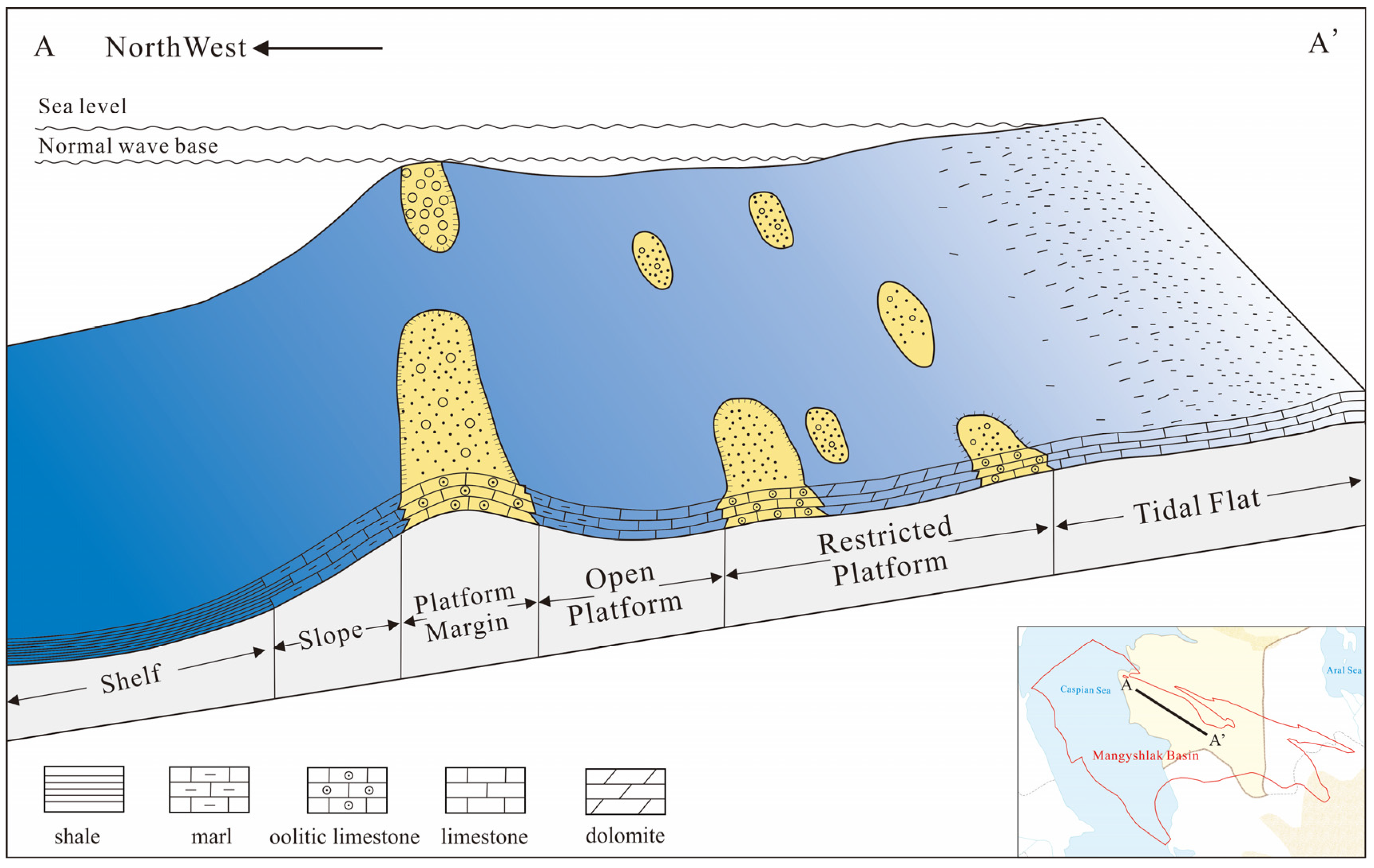
Drilling and seismic data revealed that the sedimentary environment in the basin during the Early and Middle Triassic was mainly platform margins and restricted platforms in shallow water areas and carbonate slopes and open non-marine shelves in deep water areas. A Triassic restricted platform, platform margin–carbonate slope–shelf carbonate sedimentary facies’ model, was established for the basin. Unlike the revised Wilson rimmed carbonate platform model, the carbonate platform margin facies in the Mangeshlak Basin did not develop bioherm facies but are dominated by oolite beach (bar) deposits, which is the most favorable Triassic reservoir for the development of a sedimentary facies belt in the basin.

Author Contributions

Conceptualization and writing—original draft preparation, F.M.; funding acquisition, K.Z.; Conceptualization, Z.H.; data curation, M.M.; project administration, F.W. All authors have read and agreed to the published version of the manuscript.

Funding

This research was funded by Basic Science Foundation of Institute of Geomechanics (No. DZLXJK202406), and the Geological Survey Project of China Geological Survey on International Cooperation in Oil and Gas Geological Survey of Key Global Areas (No. DD20240096), and Global Oil and Gas Exploration Situation and Industrial Cooperation Research (No. DD20243229).

Institutional Review Board Statement

Not applicable.

Informed Consent Statement

Not applicable.

Data Availability Statement

The original contributions presented in this study are included in the article. Further inquiries can be directed to the corresponding author.

Conflicts of Interest

The authors declare no conflict of interest.

References

  1. Hu, Y.; Shi, B.; Fan, Z.; Wan, L.; Wang, Z. Atlas of Global Oil and Gas Exploration, Development and Cooperation; Petroleum Industry Press: Beijing, China, 2020; pp. 66–82. [Google Scholar]
  2. Gan, K. Evolution and oil and gas distribution of the Tethys domain. Mar. Pet. Geol. 2000, 5, 21–29. [Google Scholar]
  3. Yang, S.; Jia, C.; Chen, H.; Wei, G.; Cheng, X.; Jia, D.; Xiao, A.; Guo, Z. Evolution of the Tethys tectonic belt, formation of the northern margin basin group and prospects for natural gas exploration in Tarim. Chin. Sci. Bull. 2002, 47, 36–39. [Google Scholar] [CrossRef]
  4. Wen, T. Study on the Main Controlling Factors of Oil and Gas Enrichment Differences in the Northern Margin Basins of the West Asian Section of the Tethys Domain. Master’s Thesis, China University of Petroleum, Beijing, China, May 2019. [Google Scholar]
  5. Tusken; Liu, B.; Shi, Y.; Zhang, Z.; Du, S. Key Study on Tectonic Evolution and Petroleum System of Mangyshlak Basin, Kazakhstan. Geol. Rev. 2018, 64, 509–520. [Google Scholar]
  6. Jia, C.; Yang, S.; Chen, H.; Wei, G. Structural Geology and Natural Gas of the Northern Tethys Basin Group; Petroleum Industry Press: Beijing, China, 2001; pp. 1–161. [Google Scholar]
  7. Zhumabekov, A.; Liu, Z.; Portnov, V.; Wei, X.; Chen, X. Integrating the geology, seismic attributes, and production of reservoirs to adjust interwell areas: A case from the Mangeshlak Basin of West Kazakhstan. Appl. Geophys. 2021, 18, 420–430. [Google Scholar]
  8. Zonenshain, L.P.; Kuzmin, M.I.; Natapov, L.M. Geology of the USSR: A Plate-Tectonic Synthesis, Geodynamics Series; American Geophysical Union: Washington, DC, USA, 1990; Volume 21, pp. 1–224. [Google Scholar]
  9. Pleshcheyev, I.A.; Schlezinger, A.Y. History of the formation of relief in Mangeshlak and its connection to major tectonic structures. Bull. La Soc. Nat. Moscou Sect. Geol. 1959, 34, 61–74. [Google Scholar]
  10. Ulmishek, G. Petroleum Geology and Resources of the Middle Caspian Basin [DB/OL]; US Geological Survey: Reston, VA, USA, 2001. Available online: http://geology.cr.usgs.gov/pub/bulletins/b2201-a (accessed on 17 June 2025).
  11. Rabbani, A.I.; Al-Hajri, S.; Hussain, K.S.; Blackbourn, G.; Qi, C.; Suboyin, A.; Ponnambathayil, J.A.; Rahman, M.M.; Haroun, M.; Gibrata, M.A.; et al. Reservoir Charaterization of the Pliocene Red Series, Lam Field and Surrounding Areas, Offshore Western Turkmenistan. J. Pet. Geol. 2023, 46, 77–102. [Google Scholar] [CrossRef]
  12. You, G.; Wang, Z.; Zheng, N.; Yue, L. Formation and evolution of sedimentary basins in Central Asia and adjacent areas and their hydrocarbon potential. Geol. China 2010, 37, 1175–1182. [Google Scholar]
  13. Tusken; Li, J.; Li, H.; Li, W.; Mao, X.; Wang, H. Tectonic evolution and hydrocarbon content of basins in Central Asia and adjacent areas. Mod. Geol. 2014, 28, 573–584. [Google Scholar]
  14. Li, F. Oolitic Structural Characteristics and Temporal and Spatial Distribution at the Permian-Triassic Transition: Indications for Paleo-Ocean Environments. Master’s Thesis, China University of Geosciences, Beijing, China, 2016. [Google Scholar]
  15. Zhang, H. Study on the Genesis Mechanism of Carbonate Concretions. Master’s Thesis, China University of Petroleum (East China), Qingdao, China, 2016. [Google Scholar]
  16. Guo, Q.; Jin, Z. Oolite grain size characteristics and their indicative significance: A case study of the Cambrian Zhangxia Formation section in Xiaweidian, Xishan, Beijing. Acta Sedimentol. Sin. 2020, 78, 737–746. [Google Scholar]
  17. Hou, E.; Gao, J.; Wang, G.; Wang, X.; Xu, T.; Qiao, B. Sedimentary characteristics and environmental significance of the oolitic beach limestone of the Upper Triassic Riganpeicuo Formation in the Geze area, Tibet. Mod. Geol. 2014, 33, 1067–1075. [Google Scholar]
  18. Li, K.; Xie, S.; Lei, L.; Bao, Z.; Wo, Y.; Zhang, D.; Zhang, H. Experimental study on microstructure characteristics of dissolution of oolitic carbonate rocks. Mar. Oil Gas Geol. 2018, 23, 61–70. [Google Scholar]
  19. Lin, X.; Zhang, B.; Xiao, H.; Cao, G.; Liu, R.; Cao, Q.; Wang, Y.; Zheng, Y.; Shi, Y.; Yang, K.; et al. Logging facies patterns of different combinations of dolomite and evaporite in Triassic in eastern Sichuan and their exploration significance. Comput. Technol. Geophys. Geochem. Explor. 2023, 45, 443–452. [Google Scholar]
  20. Liu, K.; Gao, F.; Chen, L.; Bu, X. Study on well logging facies based on core calibration of S group of carbonate reservoir in A oilfield, Iran. China Pet. Chem. Stand. Qual. 2019, 39, 108–109. [Google Scholar]
  21. Zhang, X.; Miao, S.; Liu, X.; Liu, W.; Chen, J. Sedimentary characteristics and main controlling factors of carbonate reefs in the United Arab Emirates. China Offshore Oil Gas 2022, 34, 87–93. [Google Scholar]
  22. Guo, K.; Fan, L.; Jin, S.; Cheng, X.; Sheng, S.; Wu, J. Identification and distribution characteristics of Carboniferous carbonate platform margin belt in the eastern margin of the Caspian Sea Basin. Pet. Geol. Eng. 2023, 37, 23–30. [Google Scholar]
  23. Zheng, H.; Tian, J.; Hu, Z.; Zhang, X.; Zhao, Y.; Meng, W. Lithofacies paleogeographic evolution and sedimentary model of the Ordovician in the Tarim Basin. Pet. Nat. Gas Geol. 2022, 43, 733–745. [Google Scholar]
  24. Zhao, Y.; Lu, H.; Liu, Z.; Huang, Y.; Gong, L. Seismic phase characteristics and reef formation patterns of typical bioherms in the X Basin. China Pet. Chem. Stand. Qual. 2024, 44, 143–145. [Google Scholar]
  25. Zuo, M.; Hu, Z.; Yang, W.; Zhang, C.; Hu, M.; Mo, W. Characteristics of subsalt structure—sedimentary response of Majiagou Formation in the central and eastern part of Ordos Basin. Mar. Pet. Geol. 2021, 26, 141–149. [Google Scholar]
  26. Wang, Z.; Wang, H.; Yang, L.; Zhang, Y.; Li, D.; Guo, Y.; Liu, Y.; Pang, X. Paleogeomorphological restoration technology and application of carbonate strata under salt in S oilfield, Santos Basin, Brazil. Comput. Tech. Geophys. Geochem. Explor. 2020, 42, 629–635. [Google Scholar]
  27. Ni, X.; Chen, Y.; Wang, Y.; Xiong, R.; Zhu, Y.; Zhu, Y.; Zhang, T.; Yu, G.; Huang, L. New understanding of the deep Cambrian platform margin belt and subsalt exploration zone in Lunnan area, Tarim Basin: New evidence based on petrology, isotope correlation and seismic facies. Mar. Pet. Geol. 2020, 25, 289–302. [Google Scholar]
  28. Jiang, L.; Luan, X.; Li, Z.; Xiao, F.; Jin, L.; Xue, Y. Characteristics and controlling factors of deep-water slope sedimentation: A case study of the Roebuck Basin in Australia. Mar. Geol. Front. 2024, 40, 45–55. [Google Scholar]
  29. Yang, Y.; Jin, Z.; Bai, W.; Qiao, D.; Diao, L.; Meng, F.; Yuan, M.; Zhang, C. Sedimentary facies model and evolution characteristics of thin lacustrine carbonate rocks in the Qibei slope area of Huanghua Depression. J. Jilin Univ. (Earth Sci. Ed.) 2013, 43, 1330–1340. [Google Scholar]
  30. Jin, Z.; Shi, L.; Gao, B.; Yu, K. Sedimentary facies and facies models of carbonate rocks. Acta Sedimentol. Sin. 2013, 31, 965–979. [Google Scholar]
  31. Zhang, Y.; Li, Q.; Zheng, X.; Li, Y.; Shen, A.; Zhu, M.; Xiong, R.; Zhu, K.; Wang, X.; Qi, J.; et al. Cambrian-Ordovician platform types, evolutionary processes and favorable reservoir facies in the Gucheng-Xiaotang area in the eastern Tarim Basin. Acta Pet. Sin. 2021, 42, 447–465. [Google Scholar]
Figure 1. Structural outline map of Mangeshlak Basin (revised according to IHS).
Applsci 15 07788 g001
Figure 2. Comprehensive stratigraphic column chart of Mangeshlak Basin (revised according to IHS).
Applsci 15 07788 g002
Figure 3. Tectonic-lithofacies map of the northern margin of the West Asian section of the Tethys Realm during critical periods (revised according to [4]).
Applsci 15 07788 g003aApplsci 15 07788 g003b
Figure 4. Distribution map of discovered reserves in different layers of the Mangeshlak Basin (according to IHS, 2024).
Applsci 15 07788 g004
Figure 5. Distribution map of oil and gas fields and reservoir formation combinations in the Mangeshlak Basin.
Applsci 15 07788 g005
Figure 6. Microscopic characteristics of thin sections of oolitic limestone and oolitic dolomite in the middle and lower parts of the Middle Triassic.
Applsci 15 07788 g006
Figure 7. Sedimentary facies map of the Early, Middle, and Late Triassic Mangeshlak Basin.
Applsci 15 07788 g007aApplsci 15 07788 g007b
Figure 8. Comprehensive bar chart of sedimentary facies in the Triassic carbonate rock section of Well D2.
Applsci 15 07788 g008
Figure 9. Seismic reflection characteristics’ profile of the slope facies at the edge of the transverse platform (flattened bottom of carbonate strata).
Applsci 15 07788 g009
Figure 10. Seismic reflection characteristics’ profile of vertical platform edge facies (flattened bottom of carbonate strata).
Applsci 15 07788 g010
Figure 11. Sedimentary facies’ profile map of connected wells (bottom flattening of carbonate section).
Applsci 15 07788 g011
Figure 12. Sedimentary facies’ model of Triassic carbonate rocks in Mangeshlak Basin.
Applsci 15 07788 g012
Disclaimer/Publisher’s Note: The statements, opinions and data contained in all publications are solely those of the individual author(s) and contributor(s) and not of MDPI and/or the editor(s). MDPI and/or the editor(s) disclaim responsibility for any injury to people or property resulting from any ideas, methods, instructions or products referred to in the content.

