Featured Application
This research lays the groundwork for implementing dynamic lane assignment (DLA) in urban corridors with variable directional traffic demand. The microsimulation approach enables a validated model for optimizing traffic performance ahead of the planned real-world deployment of lane assignment within Zagreb’s urban traffic network.
Abstract
Traffic congestion in urban areas presents significant challenges to mobility, road safety, and the overall quality of the urban traffic network. This study presents a simulation-based modeling framework for dynamic lane assignment (DLA) systems designed to optimize traffic flow on Vukovar Street in Zagreb, Croatia, which is an urban corridor where the existing infrastructure fails to meet capacity demands during peak morning and afternoon hours. Using real-time traffic data and the PTV VISSIM environment, an adaptive DLA model responsive to current traffic conditions was developed and evaluated. The proposed model improves traffic flow efficiency with minimal physical infrastructure changes, focusing on maximizing capacity within existing corridor constraints. The results of this research indicate that the proposed model reduces average vehicle delay by 21.4% and shortens queue lengths by 19%. The effectiveness of the DLA approach is evaluated through comparative analysis with traditional static traffic configurations, demonstrating significant improvements in traffic efficiency, reduced travel times, and enhanced network performance. While this study is limited to a simulation environment, it provides a strong foundation for future real-world applications and offers a practical approach to improving traffic network efficiency.
1. Introduction
Urban traffic congestion remains a major challenge to maintaining efficient mobility, road safety, and the overall quality of the transport network in the cities. As the population grows, urbanization intensifies, and traffic demand exceeds the capacity of existing infrastructure, especially during peak hours. This imbalance leads to increased travel times, reduced network performance, and the inability to utilize the maximal capacity of the network [1]. Additionally, this issue is not only a constraint on mobility but also affects economic productivity and environmental health, where the decrease in the energy efficiency of the transport network directly affects fuel consumption, the emission of harmful gases, and noise levels [2,3]. Also, the research in [4] suggests that congestion may reduce urban productivity significantly, with cumulative economic impacts seen globally.
The traditional approach with “static” and non-responsive infrastructure is insufficient to meet the stochastic nature of modern urban traffic flows. Traffic management authorities explore adaptive and intelligent control systems that can respond to real-time traffic [5]. These systems and services are typically implemented in corridors where physical infrastructure expansion is limited and where the real-time control of traffic capacity variations can maximize the quality of the traffic network. Adaptive signal control, variable lane usage, and the integration of other Intelligent Transport Systems (ITS) services are being applied in urban areas, supporting both efficiency and sustainability goals. The following chapter provides a detailed review of these approaches, including international examples of their effectiveness.
Within the framework of the ITS concept, dynamic lane assignment (DLA) was introduced for its potential to reallocate traffic infrastructure in response to demand variations. DLA is defined as the dynamic redefinition of lane directions based on real-time data, enabling flexible responses to directional traffic demands [6,7,8,9]. Specific lanes can be reassigned during peak periods to match the dominant flow, while during off-peak periods, lane usage is returned to balanced (original) configurations. Unlike fixed systems, DLA responds to ongoing changes and can be integrated with other ITS services, contributing to an increase in traffic network quality in high-demand, spatially limited urban areas [10,11]. Recent studies have demonstrated the value of DLA in improving traffic efficiency and reducing congestion, especially at signalized intersections and corridors with time-dependent directional flows [12,13]. Also, adaptive control strategies combined with machine learning models and algorithms show good potential for further refining DLA performance by combining historical and real-time traffic data [14]. The authors in [15] developed a Roadrunner framework that integrates DLA with autonomous intersection control, showing an increase of over 11% in intersection capacity and reduced travel delay (under high traffic volume of over 6376 CAVs/h) by 5%. Also, the PEARL (Predictive Empowered Assignment for Reversible Lanes) system was tested on several congested expressway segments in the U.S., demonstrating that a notable improvement in traffic throughout and a reduction in travel times of over 9% can be achieved [16]. The authors in [17] evaluated a DLA-based Traffic Change system developed to improve traffic flow during roadworks on German highways. This system enables the DLA in the direction with higher demands, which can lead to a 10–15% increase in capacity in the direction of the construction site and a significant reduction in queue length. Another study on the Tsukamoto merge area of the Hanshin Area evaluated a DLA for CAVs, and it demonstrated that the system significantly reduced travel times and improved traffic flow efficiency [18]. Implementing the DLA concept in this context is designed to offer operational benefits with minimal infrastructural changes. This concept has the potential to significantly reduce congestion, improve travel times, and enhance overall network performance. Minimizing changes to existing infrastructure makes DLA a cost-effective and sustainable solution for cities facing similar challenges [19].
Our study is based on the presented research methodologies of applying a real-world microsimulation of DLA in an urban corridor with significant directional traffic variation. Vukovar Street in Zagreb was selected as a known critical corridor due to its spatial limitations and observed peak-hour congestion, making it a relevant setting for DLA development and testing. Using real-time collected traffic data, the PTV VISSIM simulation tool, and a Python environment, we created the first phase of a DLA model tailored to this corridor.
This paper contributes to the field of advanced urban traffic control strategies and provides a practical framework for planners and engineers. After the Introduction, Section 2 presents a targeted review of the relevant literature and applications of advanced traffic control and DLA. Section 3 presents the methodology and model development process, while Section 4 presents the results gathered from the simulation models. Section 5 discusses the outcomes and results, and the paper concludes with key insights and future work opportunities.
2. Literature Review
2.1. Urban Traffic Congestion and Control Strategies
Urban traffic congestion remains a critical problem that directly impacts mobility, sustainability, and productivity in rapidly expanding areas. Traditional infrastructure and fixed-time signal control cannot fulfill the needs of increasing traffic demand. This has led to the development and implementation of real-time, traffic-actuated management systems capable of adaptation to stochastic traffic conditions in urban areas. The challenges of traffic control on urban networks have encouraged innovative actuated traffic control and management systems that use real-time data to enhance and improve traffic flow quality [20]. The implementation and usage of Artificial Intelligence (AI), the Internet of Things (IoT) concept, and big and open data analytics have sped up the development of traffic control strategies. The authors in [21] proposed an integrated ITS-AI framework that dynamically adjusts signal plans using real-time sensors and collected traffic data, obtaining a nearly 15% improvement in traffic flow efficiency and an almost 20% reduction in average travel times. Another approach is the use of machine learning systems using video feeds from urban traffic networks that achieve over 93% accuracy in identifying and responding to congestion patterns, optimizing traffic on Indian streets [22]. The inability to adapt existing traffic infrastructure to new traffic situations led to the development of new solutions for traffic-dependent strategies, with the usage of modern technologies, to enable a more harmonized and efficient traffic flow [23,24]. With the focus on the implementation of the urban mobility concept, adaptive traffic control is one stable trend where real-time data collection and processing allow quick responses to variations in traffic situations. In the research presented in [25], proactive and reactive behavior for sharing traffic condition information is considered, where vehicles monitor the road traffic condition and proactively share this information when needed, considering adaptive multi-hop communication. Even though some researchers consider the main problem of traffic congestion to be that of inadequate intersection traffic control, the research in [26] developed an identification method to define the impact of both road infrastructure and traffic signal control. Another approach is the use of big data applications, which enable real-time predictive traffic management. The study in [27] introduces a traffic prediction framework based on multimodal data using machine learning techniques and validated with large datasets, making it a practical solution for real-time traffic management.
2.2. Dynamic Lane Assignment in Urban Traffic Management
In the urban traffic environment where physical infrastructure expansion is not possible, a real-time vehicle-actuated traffic control approach that can be implemented is dynamic lane assignment (DLA). DLA can contribute to optimizing urban traffic flow, particularly in physically limited traffic environments. The authors in the research [28,29] defined the concept of DLA as a novel optimal control of assigning the right-of-way of road space (infrastructure) as needed for the current traffic situation. For example, in peak traffic congestion periods, certain traffic lanes are assigned to directions with higher traffic demand, while non-peak periods allow for previously defined fixed traffic structures. Unlike static, predefined lane configurations, DLA is responsive to a real situation on the traffic network and can be integrated with other Intelligent Transport Systems (ITS services such as traveler information systems, incident control, etc.), making it suitable for high-demand urban areas that experience occasionally expected bursts of traffic [30,31]. Previous studies have demonstrated that DLA can significantly improve traffic efficiency and reduce congestion in urban areas. For example, in signalized intersections, DLA strategies were found to reduce average intersection delay by up to 14.7% compared to fixed lane assignment configurations [32], and adaptive lane configurations have proven effective in real-time management scenarios, with a reduction in average vehicle delay by up to 21.4% [33]. In the research in [34], a model combining DLA and adaptive signal control reduced total intersection delays by 1.91% and decreased the frequency of lane changing by 13.8%. This research proved that the combination of DLA systems with adaptive traffic control enables better allocation in situations with asymmetric traffic flow demands. The analysis showed that it reduced the capacity losses caused by frequent lane changes by 17.8%. Another approach is the reversible lane network design problem (RL-NDP), where DLA implementation impacted total travel time, which decreased by up to 9%; congested roads were reduced by up to 36%; and traffic delays fell by 22% [35]. A pilot implementation of reversible lanes and adaptive lane reassignment was introduced in France (in the Paris and Grenoble metropolitan areas) to enhance corridor performance [36]. In the Paris region where the research was conducted, the lane capacity increased by 7.5%, and the overall reduction in congestion volume was 15%.
This research focuses on the real-world implementation of DLA in the city of Zagreb, Croatia, at Vukovar Street, which is an excellent representation of an urban corridor with high congestion levels throughout the day. The selected corridor provides a relevant case study due to its heavy traffic flow, directional volume surges during peak times, and physical constraints that limit expansion options. A DLA model tailored to the specific needs of Vukovar Street was developed by utilizing real-time traffic data and simulation tools. The model dynamically assigns lanes based on live traffic data, adjusting lane configurations to maximize capacity within existing spatial limitations [37]. In this paper, the effectiveness of DLA in reducing congestion, improving travel times, and enhancing the overall quality of the urban traffic network will be explored with a description of the real implementation of the concept on a corridor in the city of Zagreb, Croatia. The implementation of DLA is expected to offer several advantages by focusing on real-time lane assignments. This approach can help alleviate congestion without requiring extensive physical infrastructure changes, making it a cost-effective solution for urban traffic optimization [38]. Moreover, DLA’s adaptability to fluctuating traffic patterns allows it to efficiently meet peak demands, thereby enhancing the mobility and sustainability of the urban traffic network. This paper presents a methodology and a real-time implementation of DLA on a specific part of the urban traffic network where static lane configurations cannot effectively manage and control traffic demand. Also, it provides practical insights for urban planners and policymakers aiming to optimize existing road infrastructures in similarly congested urban areas.
While DLA produced positive outcomes in the presented international contexts, applications in mid-sized European cities like Zagreb remain unexplored. This study aims to present a microsimulation-based DLA model in an urban corridor with limited expansion capacity.
3. Research Methodology and Model Development
After examining the traffic demand and fluctuations of citizens in the city of Zagreb, a suitable corridor for the testing and real-world implementation of DLA was selected. The corridor is located in the mid-western part of the city, near the Trešnjevka market zone, and is an extension of a major road connecting the eastern and western parts of the city. In this chapter, the study area (the selected corridor) and the simulation model’s development are presented with all the phases needed to implement and test DLA.
3.1. Study Area and Scope
As previously mentioned, based on the traffic analysis in the city of Zagreb, a suitable corridor for DLA implementation was selected. This corridor is located in the mid-western part of the city and forms part of the major traffic flow connecting the east with the west of Zagreb. The macro situation of the selected corridor is presented in Figure 1.
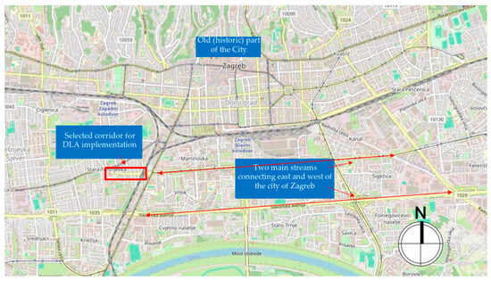
Figure 1.
The macro location of the selected corridor.
The corridor is approximately 500 m long and, based on its traffic and structural characteristics, it functions as a roadway with the main direction of movement east–west and vice versa. It consists of three traffic lanes, each between 3 and 3.5 m wide—one lane is designated for eastbound traffic, while the remaining two are designated for westbound traffic.
The corridor experiences high demand with pronounced congestion at peak hours, which the existing infrastructure and traffic control cannot manage efficiently. It includes four critical signalized intersections:
- (a)
- Vukovar Street–Trakošćanska Street–Ozaljska Street;
- (b)
- Vukovar Street–Nova Cesta Street;
- (c)
- Vukovar Street–Florijana Andrašeca Street;
- (d)
- signalized pedestrian crossing at Cernička Street.
These are presented in Figure 2.
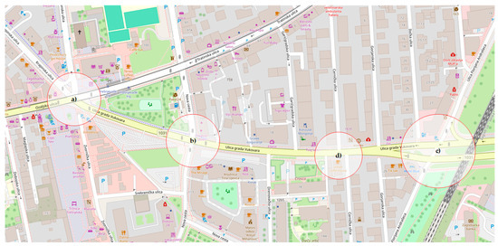
Figure 2.
The micro situation of the signalized intersections on the selected corridor.
On the selected corridor, the existing traffic cannot cope with the ability to satisfy and provide optimal traffic flow during morning and afternoon peak hours. Even though the corridor itself consists of four signalized intersections, the DLA was observed and tested on the section from intersections (b) to (c) with the inclusion of a signalized pedestrian crossing (d). To develop a reliable and calibrated simulation model, relevant traffic data needed to be collected and analyzed, which is described in the next chapter.
3.2. Data Collection and Traffic Demand Analysis
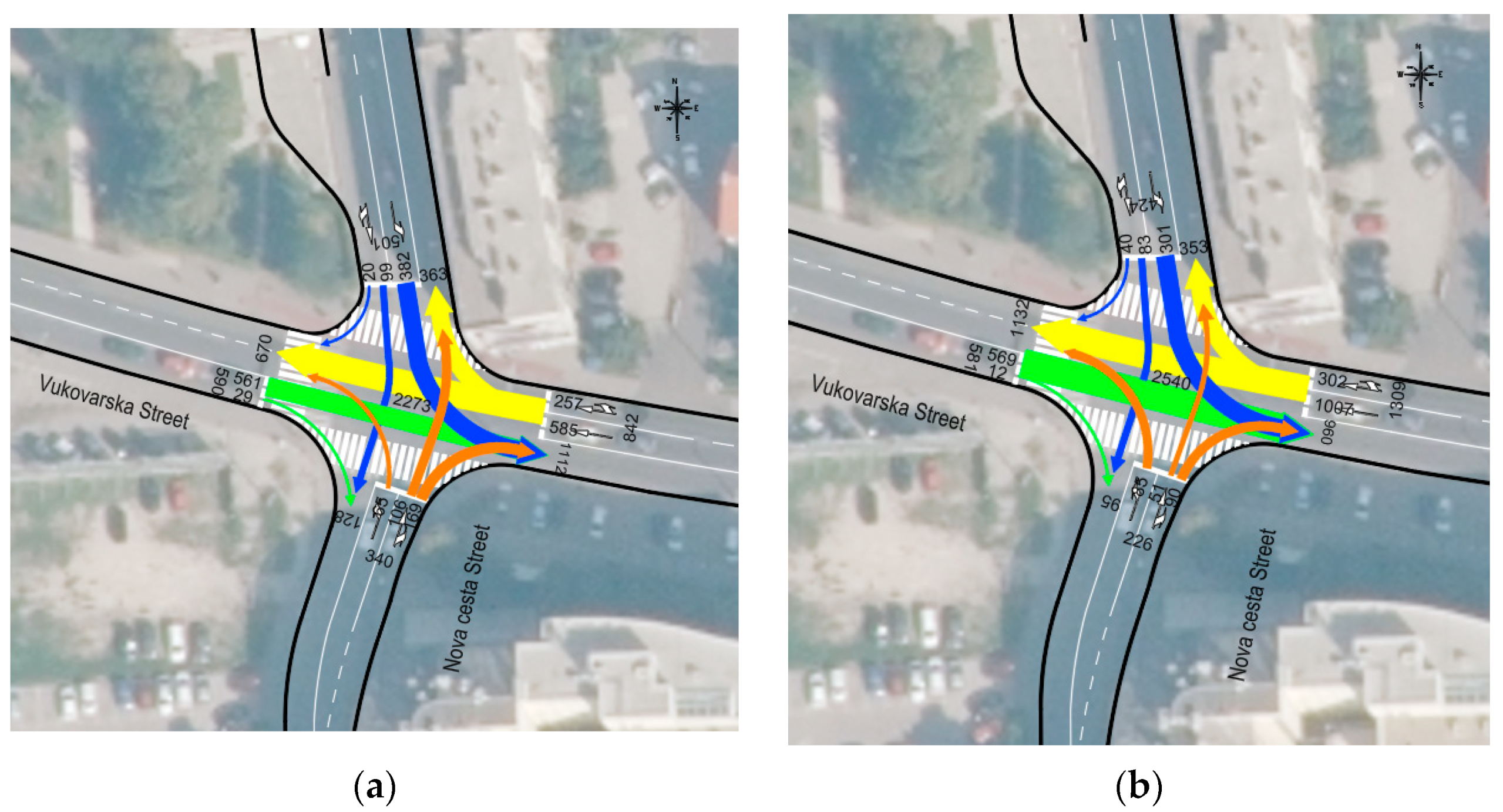
Relevant traffic data (vehicle counting) were collected in 15 min intervals over seven days (Saturday to Friday). Figure 3 presents an example of collected vehicle data, both in total (summarized) and by a group of lanes. The collection of pedestrian and bicycle traffic was carried out at signalized intersections and pedestrian crossings. As shown in Figure 3, different movement directions are represented by various colors: traffic coming from the west is marked in green, traffic from the southeast is marked in orange, traffic from the east is marked in yellow, and traffic from the north and northwest is marked in blue. Additionally, the thickness of the arrows visually represents the load in each direction of movement.
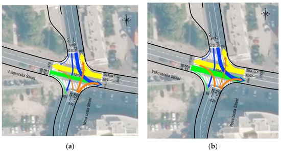
Figure 3.
Example of data collection by intersection (a) Vukovar Street–Nova Cesta Street.
Based on the traffic load illustrated in Figure 3, it is evident that the primary directions of movement during both the morning and afternoon peak hours are east–west and west–east. In contrast, the northbound and southbound directions represent secondary flows. This distribution highlights the dominant role of the east–west corridor in accommodating peak-hour traffic demand, while movements toward the north and south remain significantly less pronounced. Differences in the traffic demand in the morning (Figure 3a) and the afternoon peak hours (Figure 3b) are presented, and it can be seen that the exit flow of the west approach during the afternoon peak hour is almost 70% higher than during the morning peak hour. This information was a trigger for a scheduled DLA implementation according to the traffic demand on the entire corridor. The trend and vehicle demand variations are the same at other intersections along the selected corridor, respectively.
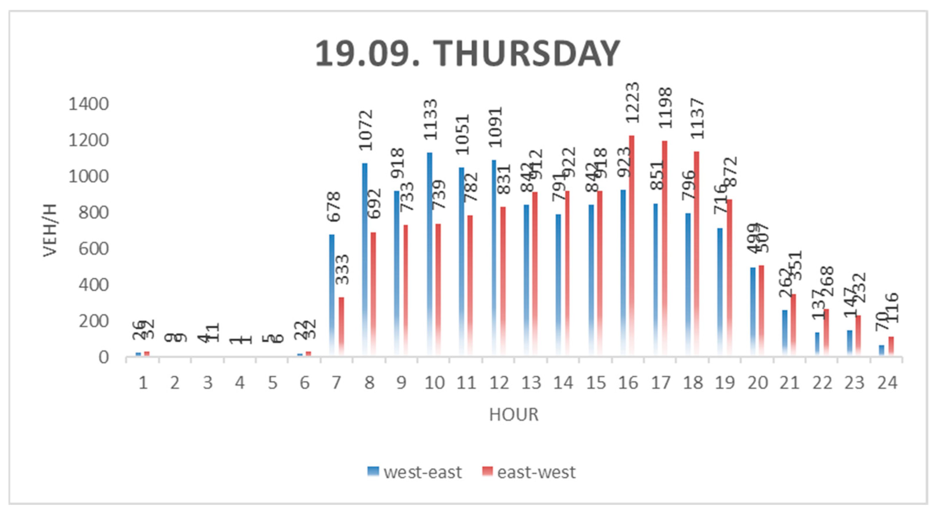
The variation in traffic load ratios between morning and afternoon peak hours is observable across all three Figure 4, Figure 5 and Figure 6. This trend highlights the dynamic nature of traffic flows and, when considering the geometry of the traffic network, underscores the potential significance of DLA implementation. Such an implementation could substantially enhance the overall functionality and quality of the traffic network.
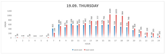
Figure 4.
Vehicle count at the intersection (a) Vukovar Street–Trakošćanska Street–Ozaljska Street on the heaviest load day.
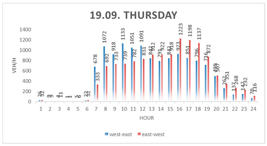
Figure 5.
Vehicle count at the intersection (b) Vukovar Street–Nova Cesta Street on the heaviest load day.
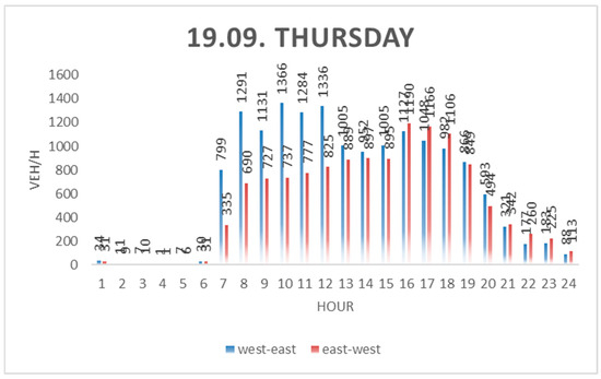
Figure 6.
Vehicle count at the intersection (c) Vukovar Street–Florijana Andrašeca Street on the heaviest load day.
Although the analysis included three intersections, a fourth signalized vehicle crossing was not graphically represented, as its traffic load primarily reflects flows from the west and east directions and does not introduce notable variation.
In addition to enhancing network efficiency and operational performance, the implementation of DLA can also play a significant role in improving traffic safety, which is discussed in more detail in the following chapter.
3.3. Safety Analysis
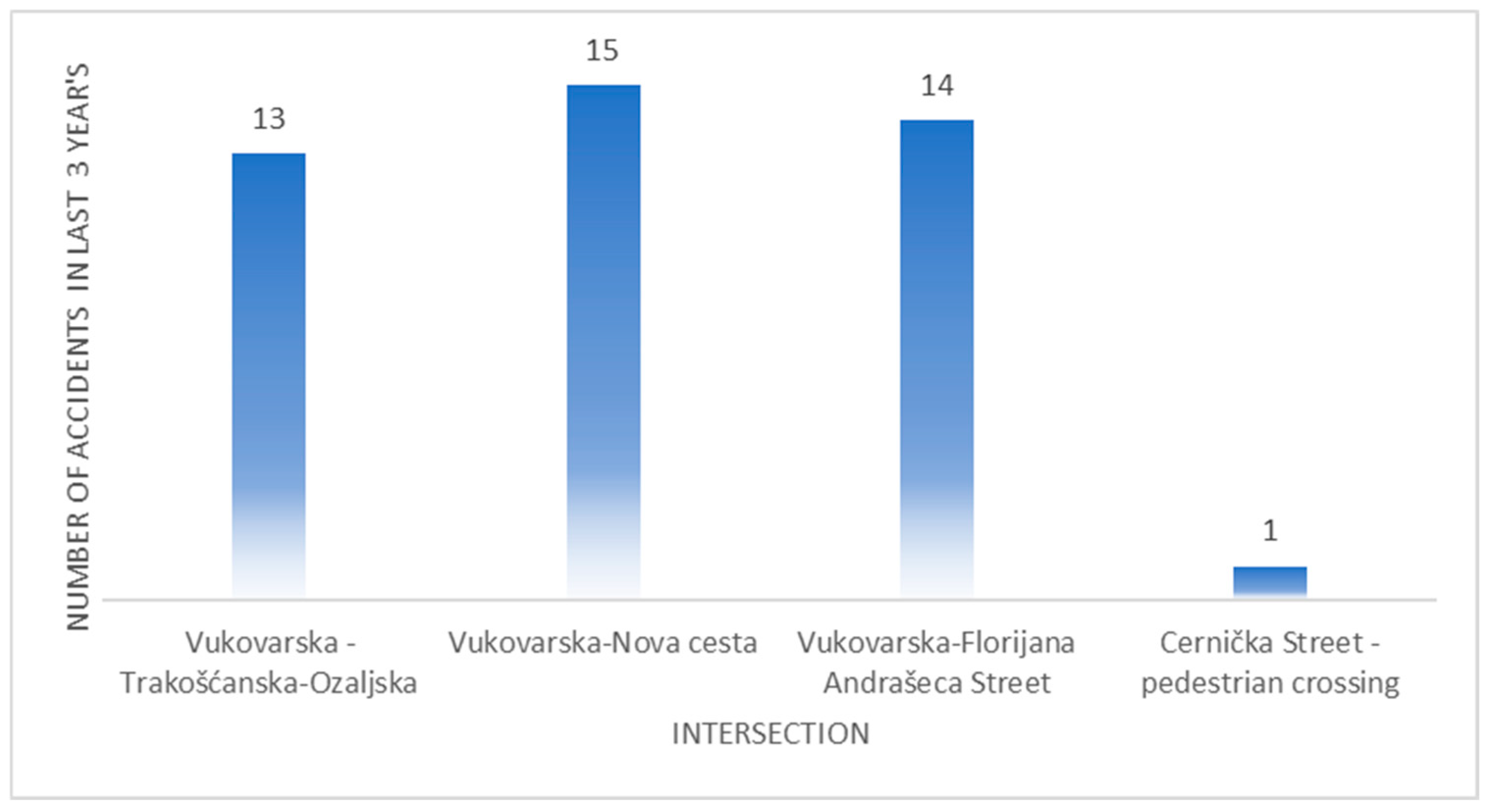
The safety analysis of the selected corridor was prepared based on statistical data on the number of accidents in the last three years (from January 2021 to July 2024). The data were obtained by the Zagreb Police Department and contain data on the number and type of traffic accidents. Figure 7 represents the number of accidents for every intersection of the selected corridor for the period of the last three years.
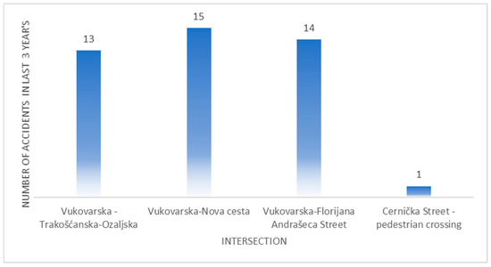
Figure 7.
Presentation of accidents at the intersections of the selected corridor.
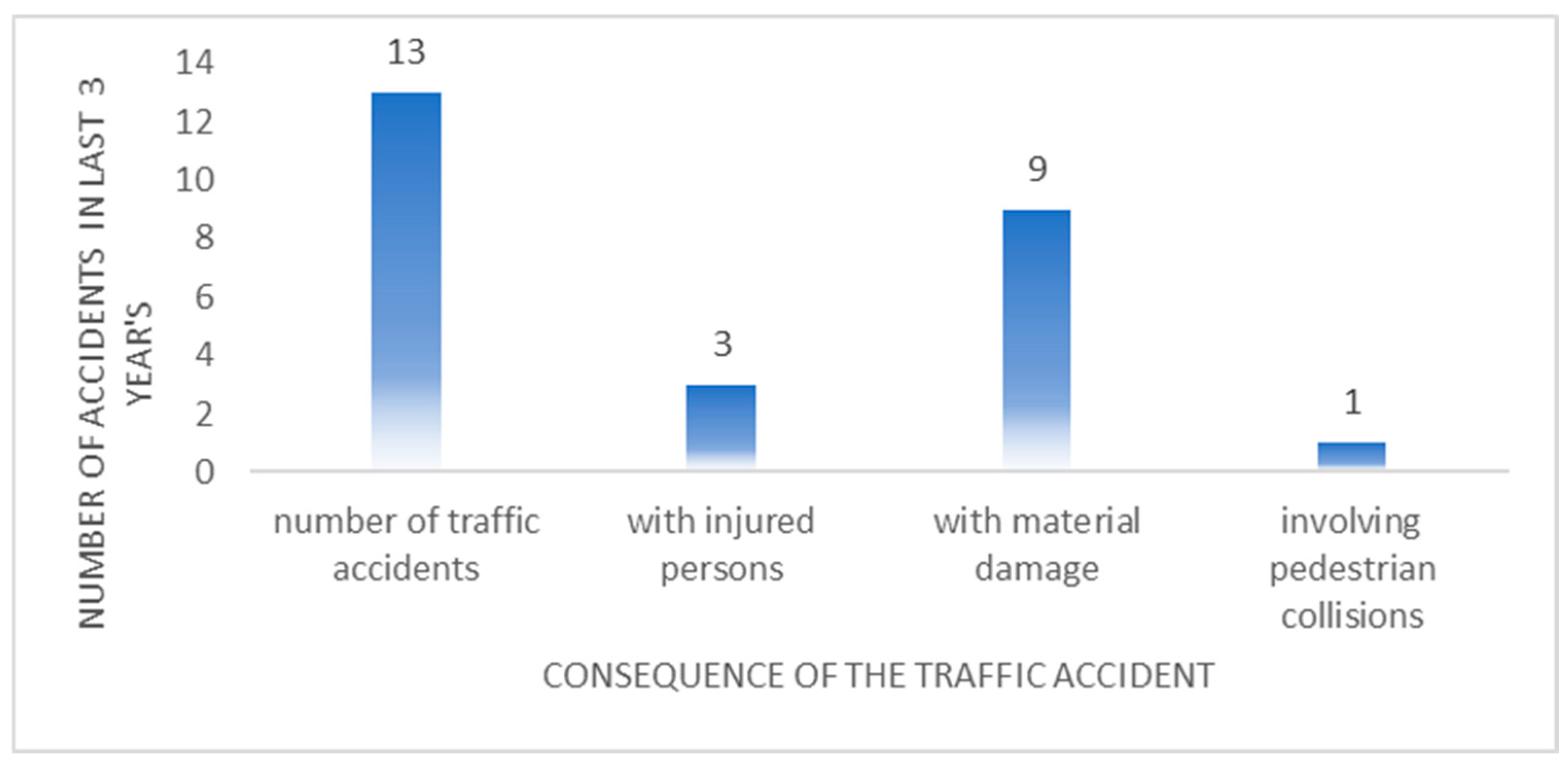
According to Figure 7, the most unsafe intersection is (b) Vukovar Street–Nova Cesta Street, with 15 recorded accidents, while at the signalized pedestrian crossing, there was only one accident in the past three years. Due to the relatively large number of accidents in the selected corridor, it is notable that there is a possibility of improvement of safety parameters through the implementation of DLA. The following graphs represent the structure (type) of the accidents at every intersection along the corridor.
As shown in previous Figure 8, Figure 9 and Figure 10, the accidents along the selected corridors are divided into accidents with injured people and accidents with material damage (with no fatalities), which points to the need for better horizontal markings of pedestrian crossings and closer considerations of traffic safety aspects, especially for pedestrians. According to papers [39,40,41], DLA implementation can significantly impact the traffic safety of a part of the network. Firstly, the traffic flow can be harmonized, reducing congestion and vehicle interactions (with the minimization of stop-and-go actions). Secondly, DLA reduces the number of lane-switching needs and actions that directly reduce the possibility of sideswipes and merging accidents. Even though drivers can be confused during the first period after DLA implementation, on a longer scale with proper signalization, it improves driver awareness and minimizes hesitation and erratic driver behavior [42].
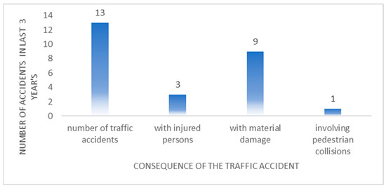
Figure 8.
Types of accidents at the intersection (a) Vukovar Street–Trakošćanska Street–Ozaljska Street.
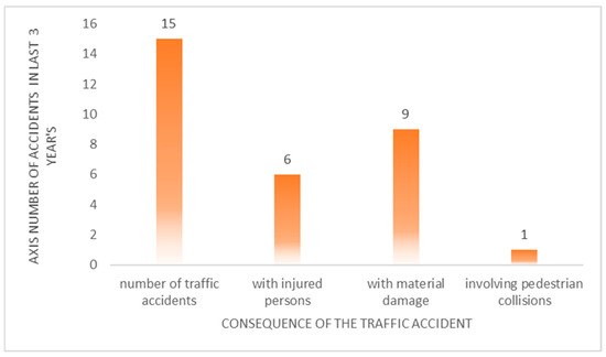
Figure 9.
Types of accidents at the intersection (b) Vukovar Street–Nova Cesta Street.
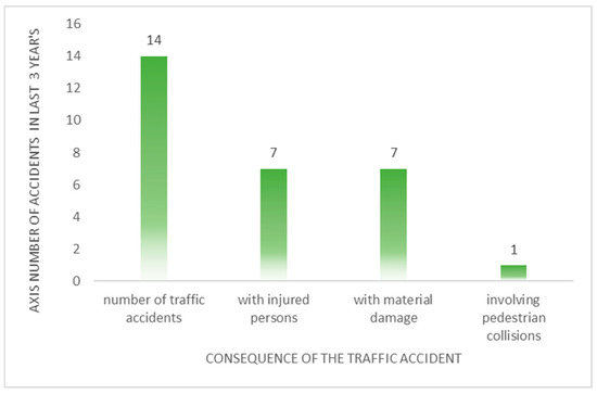
Figure 10.
Types of accidents at the intersection (c) Vukovar Street–Florijana Andrašeca Street.
3.4. Design Framework and DLA Development
After a thorough analysis of the collected traffic data (the number of vehicles, vehicle categorization, etc.) and complete traffic demand analysis, it was determined that the selected corridor has great potential for implementing the DLA concept. Existing traffic control cannot meet peak traffic demand during morning and afternoon hours, and the full capacity of traffic network elements is not used. The new traffic regulation on the selected corridor consists of a DLA implementation designed to optimize lane utilization during peak hours and reallocate lane designation based on historically collected and analyzed traffic data. It is necessary to emphasize that this is the first implementation of dynamic traffic control in Croatia’s traffic network.
According to the presented simulation model, the existing situation consists of one eastbound lane and two westbound lanes. In the DLA scenario, two phases are defined:
- The detection of increased traffic volume in westbound lanes;
- The dynamic reallocation of the center (middle) lane to operate bidirectionally, increasing capacity in the peak direction.
A transitional phase between the normal operation and DLA change ensures safe lane reconfiguration. This phase includes the following:
- Temporary closing of the center lane to empty it of vehicles already in the lane;
- Detecting the eventual presence of any remaining vehicles;
- The controlled reopening of the lane in the new direction once the transition is complete.
This DLA concept depends on real-time traffic demands, particularly during peak periods, through controlled transitions of the central lane direction.
3.4.1. Interface Configuration and Technical Setup
For the development of the simulation model, the PTV VISSIM microsimulation model (version 2024) was used and connected to the Python programming language (version 3.11.9) via the COM (Component Object Model) interface. This connection enables bidirectional communication between the simulation software and the programming environment, allowing for automated simulation control and the advanced analysis of results. In this setup, PTV VISSIM executes the actual traffic simulation, including vehicle generation, movement control, and interaction modeling within the network. Python, on the other hand, manages the simulation process—it loads the model, sets parameters, starts and stops the simulation, and retrieves and analyzes the output data. Communication between the two systems is established using the win32com.client library, which provides access to all COM objects within PTV VISSIM. This integration enables the flexible execution of multiple simulation scenarios, the optimization of input conditions, and more efficient processing of traffic data.
3.4.2. Model Structure
The traffic model is based on the integration of the PTV VISSIM microsimulation environment with an external Python-based control logic using the COM API interface. This setup enables the implementation of DLA on the middle lane, triggered by predetermined traffic conditions. The model structure is presented in Figure 11.
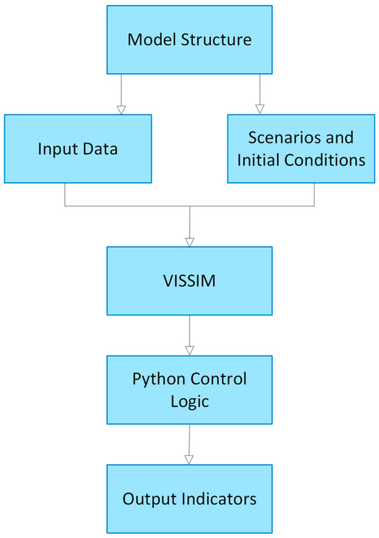
Figure 11.
The structure of the developed DLA model.
The model relies on three core components: input data, scenario design, and control logic integration within the PTV VISSIM simulation environment. Input data included geometric parameters (segment length, lane width, and signalized intersections), traffic characteristics (hourly volumes, peak/off-peak loads, and vehicle composition), and driver behavior settings (desired speed, headway, reaction time, acceleration, and deceleration profiles, with predefined values within the model for desired speed ranging from 40 to 60 km/h). The Python-based control logic, integrated via the COM API, monitors traffic flow in real time, manages the activation of DLA conditions, and orchestrates the transition between DLA scenarios to reflect realistic adaptation dynamics. To assess the model’s operational impact, node-based indicators were extracted from all signalized intersections along the corridor for each movement direction. These included total vehicle throughput (Vehs(All) [vehicles/hour]), cumulative delay (VehDelay(All) [seconds]), the average queue length per lane (Qlen [meters]), numerical level of service (LOSVal(All)), and carbon monoxide emissions (EmissionsCO [grams]). Together, these indicators provide a multidimensional evaluation of system performance, combining traffic efficiency, service quality, and environmental impact across all tested configurations.
3.4.3. DLA Modeling
The DLA concept was developed through the Python–VISSIM interface to enable dynamic lane direction changes in response to varying traffic conditions. This process incorporated parameter tuning, stochastic variability, and iterative scenario testing to refine model behavior and validate simulation outputs.
To assess DLA performance under high-demand conditions, the morning peak hour was selected as the primary use case. Emphasis was placed on addressing the imbalance in lane allocation: the corridor currently provides one lane for west-to-east traffic and two lanes for the opposite direction despite significantly increased eastbound volumes during the morning rush period. This asymmetry results in operational inefficiencies under the static lane arrangement.
Accordingly, three simulation scenarios were introduced: a calibrated baseline without DLA (Scenario 1), an active DLA configuration during the morning peak (Scenario 2), and a transitional setup (Scenario 3) capturing the effects of real-time directional switching between morning and afternoon flow patterns.
In the DLA-enabled scenarios, the central lane dynamically accommodates eastbound traffic when predefined congestion thresholds are exceeded. This logic (Figure 12) also incorporates a temporary closure period during lane reversal to ensure vehicle clearance and maintain operational safety. This dynamic configuration highlights the adaptability of the DLA system in managing directional traffic imbalances and improving overall corridor performance.
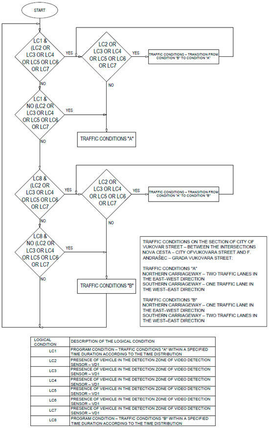
Figure 12.
The logic of DLA modeling according to traffic conditions.
4. Results
After relevant traffic data were collected, the existing traffic model was developed and calibrated in the PTV VISSIM simulation tool. The existing traffic model enables precise calibration, verification, and validation of selected evaluation parameters. Also, the main purpose of the calibrated existing traffic model (with defined evaluation parameters) is to ensure a basis for the evaluation of newly proposed scenarios and their benefits. After the traffic model of the existing traffic situation was developed and calibrated in the PTV VISSIM tool, the DLA concept was developed and then implemented as an upgrade of the existing model.
4.1. Calibration and Validation of Microsimulation Model
The calibration of the model was performed with GEH statistics [43], which is defined by the following equation:
where
M—hourly traffic from the simulation model;
C—real-world hourly traffic collected from the field.
GEH statistics facilitate a comparison between two traffic volume sets: real-world volumes and simulation-derived volumes. A GEH value below five indicates a suitable calibration of the simulation model, ensuring that traffic parameters closely reflect real-world conditions. With that, at least 85% of the total traffic volume should have a GEH value lower than five to confirm the model’s reliability. On the other hand, if the GEH value exceeds 10, the model is classified as inaccurate, indicating that it does not accurately represent the actual traffic conditions. In this research, GEH values for all approaches of the simulation model were below five, indicating that the model is adequately defined and calibrated. As mentioned earlier, the simulation models were developed using the PTV VISSIM 2024 software, with a duration of 4500 [s]. The first 900 [s] were excluded from the evaluation due to the model’s “warm-up” period. Additionally, based on the collected and analyzed traffic data, the period from 7:00 to 12:00 a.m. was selected for DLA implementation.
To ensure the reliability of the simulation results, the model was validated using the empirical data on average travel times collected during a representative weekday that matched the conditions used for demand input. Validation focused on the total time spent on the network by vehicles traveling in both east-to-west and west-to-east directions. For each direction, three controlled field runs were conducted, and the recorded average travel times were compared with the average total time spent (TTS) obtained from ten simulation runs under the baseline (non-DLA) scenario. The TTS indicator served as the key metric for verifying the model’s temporal accuracy. In cases where notable deviations were observed, driver behavior parameters such as desired speed, headway, and acceleration profiles were iteratively adjusted to improve alignment with real-world conditions. Additionally, traffic signal plans from the field were analyzed and verified against the modeled settings to ensure consistency in phase sequences, cycle lengths, and coordination. This comprehensive validation process confirmed that the model accurately replicates observed traffic dynamics and provides a reliable foundation for evaluating the impact of dynamic lane assignment strategies.
4.2. Evaluation Parameters and Results
The defined evaluation parameters were extracted from the node evaluation option in PTV VISSIM, which are relevant for the representation of the DLA impact. The evaluation parameters are the following:
- Vehs(All)—the number of vehicles [n/h];
- VehDelay(All)—the delay of all vehicles on the observed intersection [s];
- Qlen—the queue length per lane on the observed intersection [m];
- LOSVal(All)—the level of service as a numerical value;
- EmissionsCO—emissions of carbon monoxide [g].
Each of the evaluation parameters was recorded for all movement directions at three signalized intersections of the observed corridor (excluding the pedestrian crossing/intersection). Below are the results of the existing situation simulation and the proposed DLA implementation scenario for the morning peak hour (7:00–8:00 a.m.). The analysis of the results is presented in the Discussion section. The results are presented separately for each intersection within the traffic model (three signalized intersections). For each location, the previously defined evaluation parameters are presented for the existing situation and the proposed DLA implementation scenario during the morning peak hour.
Table 1 presents the simulation results for the intersection of Vukovar Street–Trakošćanska Street–Ozaljska Street. The same evaluation parameters are presented for the remaining signalized intersections in Table 2 and Table 3.

Table 1.
The results of the simulation for the existing situation and DLA situation of Vukovar Street–Trakošćanska Street–Ozaljska Street.
Table 2.
The results of the simulation for the existing situation and DLA situation of Vukovar Street–Nova Cesta Street.
Table 3.
The results of the simulation for the existing situation and DLA situation of Vukovar Street–Florijana Andrašeca Street.
These simulation results provide the basis for evaluating the effectiveness of DLA implementation. A detailed comparison and analysis of the observed differences is presented in the Discussion chapter. All the results (approach detailed) are available from the authors but are not presented due to paper length limitations.
5. Discussion
After the development of the existing traffic model and the implementation of the DLA concept in the upgraded model, the results were collected and presented in the previous chapter. The main objective is to evaluate the effectiveness of DLA in improving traffic flow and to secondarily observe its environmental performance. As mentioned before, the defined evaluation parameters are the number of vehicles, vehicle delay, the average queue length, level of service, and the emission of CO, which will all be separately considered.
5.1. Number of Vehicles, Vehicle Delay, and Level of Service
The total number of vehicles passing through the simulation model was slightly higher in the DLA scenario (0.02%, 0.05%, and 0.03%), which indicates that DLA implementation increased the intersection flow by reallocating lanes to match directional demand during peak hours. Overall, more vehicles were processed per hour, followed by a significant reduction in the average vehicle delay. The results of the DLA implementation were most notable at the middle-signalized intersection (Vukovar Street–Nova Cesta Street), where vehicle delay was reduced by 58.05%. At the edge intersections of the simulation model, the situation was slightly different because DLA did not have a direct impact on the traffic situation. On the Vukovar Street–Trakošćanska Street–Ozaljska Street intersection, the vehicle delay increased by 16.97%, and on the Vukovar Street–Florijana Andrašeca Street intersection, the vehicle delay was reduced by 5.73%.
As for the level of service values, it must be noted that the values in the tables represent the internal PTV VISSIM performance score, which is not based solely on the average delay but also on the volume-to-capacity ratio, signal plan complexity, and other parameters. Nevertheless, the values follow the number of vehicles and vehicle delay trend, so at the middle intersection, the LoS is increased from D to C, suggesting that DLA has a positive effect on operational performance. At the first intersection (eastbound direction), the LoS was slightly decreased from B to C following the same explanation as the vehicle delay, and at the last intersection, the LoS was increased from the value C to B. It can be noted that with the implementation of DLA, the capacity in the eastbound direction is increased, following smoother traffic flow and better lane utilization.
5.2. Queue Length Analysis
Queue length serves as an indicator of congestion at signalized intersections, and the ability of the control and optimization techniques to process the arriving vehicles is determined. Again, as with the previous indicators, the greatest queue length decrease is at the middle intersection under the DLA scenario by approximately 19.3%. The first intersection of the model experiences some increase in the queue length by 28.49% (from 11.61 m to 14.92 m). Also, as expected, at the last intersection of the model (Vukovar Street–Florijana Andrašeca Street), the queue length decreased by 28.22%, or from 14.19 m to 10.19 m. It can be noted that with the dominant eastbound direction with active DLA, traffic can clear more effectively during each signal cycle. This is particularly important in dense urban corridors where physical limitations and intersection spacing exist.
5.3. Environmental Impact—CO Emissions
The carbon monoxide (CO) emissions were analyzed as part of the evaluation to assess the environmental implications of DLA implementation. According to the results, the difference in CO emissions before and after the DLA implementation is not noticeable, with the only reduction being at the Vukovar Street–Nova Cesta Street intersection. The major decrease was from 4028.97 g to 2183.96 g, which represents 45.77%. Again, the main reason for such a large decrease in CO emissions is the implementation of the DLA concept, which impacts the harmonization of the traffic flow. As expected, on the edge intersections, there is an increase in CO emissions (15.22% at the Vukovar Street–Trakošćanska Street–Ozaljska Street intersection and 2.17% at the Vukovar Street–Florijana Andrašeca Street intersection).
Even though this research focuses on the isolated implementation of DLA on Vukovar Street, the selected corridor is an integral part of an urban traffic network. The presence of pedestrians and public transport services influences the effectiveness of signal control strategies, and this was considered during the development of the simulation model. Also, the intergreen matrices for pedestrians were calculated and included in the signal timings. The implementation of DLA will be taken into account when analyzing the impact and interactions with adjacent corridors, coordinated signal control, and overall network performance. Also, this study did not incorporate surrogate safety measures (such as Time-to-Collision (TTC)), but their importance in evaluating traffic safety is notable. Indicators like TTC show the real nature of vehicle conflicts and the safety implications of lane assignment strategies. However, due to the defined scope of this research, the current study focused on performance metrics and traffic network parameter improvements. In the next phases of this research, we will integrate surrogate safety analysis using tools like the surrogate safety assessment model (SSAM) or similar to assess the impact of DLA on traffic safety.
5.4. Limitations
While the findings of this study offer promising insights into the potential benefits of dynamic lane assignment (DLA) in urban traffic corridors, several limitations should be acknowledged. First, the analysis was conducted using a single case study—Vukovar Street in Zagreb—which, although representative of directional congestion in urban settings, may limit the generalizability of the results to cities with different geometric, regulatory, or traffic flow characteristics.
Second, the model assumes the reliable and timely availability of traffic data to trigger lane direction changes. In practice, the effectiveness of a DLA system would depend heavily on the accuracy and responsiveness of real-time data collection infrastructure, such as traffic detectors, sensors, and communication systems. Third, driver behavior in the model does not fully account for behavioral adaptation to dynamic lane changes, especially in the early phases of implementation when unfamiliarity with the system may affect compliance and performance.
Finally, the implementation of DLA systems requires significant technological, institutional, and operational readiness, including dynamic signage, signal control integration, and traffic management protocols. These factors were not explicitly modeled but would play a crucial role in real-world deployment. Despite these limitations, the study provides a robust framework for evaluating core operational benefits under controlled conditions and can serve as a foundation for future, more complex investigations.
6. Conclusions
In this research, the modeling and possible real-world implementation of a dynamic lane assignment (DLA) system on one of the most congested corridors in the city of Zagreb–Vukovar Street was explored. The first phase of a DLA concept was developed through the integration of collected real-time traffic data, detailed demand analysis, and microsimulation using the PTV VISSIM tool with Python to address uneven peak-hour traffic demand. The main goal is to optimize traffic flow without physical infrastructure expansion.
The simulation model was calibrated, and the model with the proposed DLA concept was developed. In the first phase, the middle lane acts as a dynamic lane, adjusting the direction according to traffic demand. The simulation results confirmed that DLA can significantly improve the performance of the traffic network when applied at targeted corridors. The most notable improvements in evaluation parameters were achieved at the middle intersection of the corridor where the DLA concept was implemented (Vukovar Street–Nova Cesta Street). Vehicle delay was reduced by over 58%, queue length was decreased by 19%, and CO emissions dropped by 46%, respectively. These results demonstrate that DLA can reallocate the capacity in traffic networks to match variable traffic demand.
On the other hand, the DLA implementation had a direct impact on the edge intersections and delay, and emissions slightly increased due to downstream prioritization. Network-wide coordination and careful scenario planning to avoid displacing the congestion are essential.
Future research will focus on expanding the scope of DLA implementation but also on implementing the DLA variable in smaller time frames and with greater frequency. Also, this first phase of DLA implementation is planned for real-world implementation at the observed corridor, and the impacts on real traffic will be observed and analyzed. Additionally, simulations will be extended to cover full-day traffic variations and multi-peak scenarios.
Overall, this research offers valuable insights for urban traffic planners and policymakers who focus on improving traffic efficiency and sustainability in dense urban environments using Intelligent Transport System services.
Author Contributions
Conceptualization, M.V. and L.D.; Methodology, M.V. and L.D.; Formal analysis, L.D. and M.M.; Investigation, M.V. and L.D.; Resources, M.V.; Data curation, L.D. and M.M.; Writing—Original draft, M.V.; Writing—Review and editing, M.V. and L.D. All authors have read and agreed to the published version of the manuscript.
Funding
This research received no external funding.
Institutional Review Board Statement
Not applicable.
Informed Consent Statement
Not applicable.
Data Availability Statement
The collected and analyzed data for the current research are available from the corresponding author upon reasonable request.
Conflicts of Interest
The author Luka Dedić was employed by the company Prometis Ltd. The remaining authors declare that the research was conducted in the absence of any commercial or financial relationships that could be construed as potential conflicts of interest.
References
- Grigore, M. Congestion in Large Urban Agglomerations and Solutions to Reduce It. Ann. Acad. Rom. Sci. Ser. Eng. Sci. 2023, 15, 31–41. [Google Scholar] [CrossRef]
- Bechlioulis, C.; Kyriakopoulos, K. Neuro-Adaptive Traffic Congestion Control for Urban Road Networks. In Proceedings of the European Control Conference (ECC), Limassol, Cyprus, 12–15 June 2018; pp. 1685–1690. [Google Scholar] [CrossRef]
- Vilke, S.; Tadić, F. Review of Good Practices in the Introduction of Traffic Management Systems and Urban Mobility. J. Marit. Transp. Sci. 2020, 59, 95–113. [Google Scholar] [CrossRef]
- Hounsell, N.; Shrestha, B.; Piao, J.; McDonald, M. Review of Urban Traffic Management and the Impacts of New Vehicle Technologies. IET Intell. Transp. Syst. 2009, 3, 419–428. [Google Scholar] [CrossRef]
- Jing, P.; Huang, H.; Chen, L. An Adaptive Traffic Signal Control in a Connected Vehicle Environment: A Systematic Review. Information 2017, 8, 101. [Google Scholar] [CrossRef]
- Xia, X.; Ma, X.; Wang, J. Control Method for Signalized Intersection with Integrated Waiting Area. Appl. Sci. 2019, 9, 968. [Google Scholar] [CrossRef]
- Li, W.; Li, J.; Han, D. Dynamic Lane Reversal Strategy in Intelligent Transportation Systems in Smart Cities. Sensors 2023, 23, 7402. [Google Scholar] [CrossRef]
- Cai, B.; Feng, Y.; Wang, X.; Quddus, M. Highly Accurate Deep Learning Models for Estimating Traffic Characteristics from Video Data. Appl. Sci. 2024, 14, 8664. [Google Scholar] [CrossRef]
- Liu, H.; Song, X.; Liu, B.; Liu, J.; Gao, H.; Liang, Y. A Dynamic Lane-Changing Driving Strategy for CAV in Diverging Areas Based on MPC System. Sensors 2023, 23, 559. [Google Scholar] [CrossRef]
- Gunarathna, U.; Xie, H.; Tanin, E. Real-time Road Network Optimization with Coordinated Reinforcement Learning. ACM Trans. Intell. Syst. Technol. 2023, 14, 1–30. [Google Scholar] [CrossRef]
- Cardellini, M.; Dodaro, C.; Maratea, M.; Vallati, M. Optimising Dynamic Traffic Distribution for Urban Networks with Answer Set Programming. Theory Pract. Log. Program. 2024, 24, 825–843. [Google Scholar] [CrossRef]
- Zheng, Y.; Hua, X.; Wang, W.; Xiao, J.; Li, D. Analysis of a Signalized Intersection with Dynamic Use of the Left-Turn Lane for Opposite through Traffic. Sustainability 2020, 12, 7530. [Google Scholar] [CrossRef]
- Zhu, Z.; Zhu, M.; Liu, M.; Li, P.; Tang, R.; Zhang, X. A Cooperative Optimization Model for Variable Approach Lanes at Signaled Intersections Based on Real-Time Flow. Sensors 2024, 24, 5701. [Google Scholar] [CrossRef] [PubMed]
- Rastin, Z.; Söffker, D. Multi-Level Feature Extraction and Classification for Lane Changing Behavior Prediction and POD-Based Evaluation. Automation 2024, 5, 310–323. [Google Scholar] [CrossRef]
- Wang, M.I.-C.; Wang, J.; Wen, C.H.-P.; Chao, H.J. Roadrunner: Autonomous Intersection Management with Dynamic Lane Assignment. In Proceedings of the 2020 IEEE 23rd International Conference on Intelligent Transportation Systems (ITSC), Rhodes, Greece, 20–23 September 2020; pp. 1–7. [Google Scholar] [CrossRef]
- Liu, C.; Yang, H.; Ke, R.; Wang, Y. Toward a Dynamic Reversible Lane Management Strategy by Empowering Learning-Based Predictive Assignment Scheme. IEEE Trans. Intell. Transp. Syst. 2022, 23, 23311–23323. [Google Scholar] [CrossRef]
- Schwietering, C.; Feldges, M. Improving Traffic Flow at Long-Term Roadworks. Transp. Res. Procedia 2016, 15, 267–282. [Google Scholar] [CrossRef]
- Hattori, Y.; Shiomi, Y.; Sano, M.; Matsunaga, H. Evaluation of a Dynamic Lane Assignment on Urban Freeways by Using a Microscopic Traffic Flow Simulation. Transp. Res. Rec. 2023, 2678, 77–87. [Google Scholar] [CrossRef]
- Cai, J.; Li, Z.; Xiao, Y.; Zhou, Z.; Long, Q.; Yu, J.; Zhang, J.; Zhang, L. Reversible Lane Optimization of the Urban Road Network Considering Adjustment Time Constraints. Sustainability 2023, 15, 1381. [Google Scholar] [CrossRef]
- Li, D.; Schutter, B. Distributed Model-Free Adaptive Predictive Control for Urban Traffic Networks. IEEE Trans. Control Syst. Technol. 2021, 30, 180–192. [Google Scholar] [CrossRef]
- Santhiya, P.; Jebadurai, I.J.; Paulraj, G.J.L.; Karan, S.K. ITS-AI Integration: Enhanced Strategies for Mitigating Urban Traffic Congestion. In Proceedings of the 5th International Conference on Recent Trends in Computer Science and Technology (ICRTCST), Jamshedpur, India, 9–10 April 2024; pp. 376–381. [Google Scholar] [CrossRef]
- Chaudhary, A.; Meenakshi, M.; Rahman, M.; Srinivasan, S.; Sharma, S. Enhancing Urban Mobility: Machine Learning-Powered Fusion Approach for Intelligent Traffic Congestion Control in Smart Cities. Int. J. Syst. Assur. Eng. Manag. 2025. [Google Scholar] [CrossRef]
- Wang, S.; Djahel, S.; McManis, J. A Multi-Agent Based Vehicles Re-Routing System for Unexpected Traffic Congestion Avoidance. In Proceedings of the 17th International IEEE Conference on Intelligent Transportation Systems (ITSC), Qingdao, China, 8–11 October 2014; pp. 2541–2548. [Google Scholar] [CrossRef]
- Vujić, M.; Gregurić, M.; Dedić, L.; Nečoska, D.K. The Impact of Unconditional Priority for Escorted Vehicles in Traffic Networks on Sustainable Urban Mobility. Sustainability 2024, 16, 151. [Google Scholar] [CrossRef]
- Gomides, T.; Grande, R.; Souza, F.; Guidoni, D. RIDER: Proactive and Reactive Approach for Urban Traffic Management in Vehicular Networks. In Proceedings of the 16th International Conference on Distributed Computing in Sensor Systems (DCOSS), Marina del Rey, CA, USA, 25–27 May 2020; pp. 51–58. [Google Scholar] [CrossRef]
- Yue, W.; Li, C.; Chen, Y.; Duan, P.; Mao, G. What is the Root Cause of Congestion in Urban Traffic Networks: Road Infrastructure or Signal Control? IEEE Trans. Intell. Transp. Syst. 2022, 23, 8662–8679. [Google Scholar] [CrossRef]
- Qiu, J.; Zhao, Y. Traffic Prediction with Data Fusion and Machine Learning. Analytics 2025, 4, 12. [Google Scholar] [CrossRef]
- Ye, Q.; Feng, Y.; Candela, E.; Escribano Macias, J.; Stettler, M.; Angeloudis, P. Spatial-Temporal Flows-Adaptive Street Layout Control Using Reinforcement Learning. Sustainability 2022, 14, 107. [Google Scholar] [CrossRef]
- Kou, W.; Zhang, S.; Liu, F.; Pang, L. Dynamic Optimization of Exclusive Bus Lane Location Considering Reliability: A Case Study of Beijing. Appl. Sci. 2024, 14, 9777. [Google Scholar] [CrossRef]
- Vishwakarma, S.; Goliya, D.; Mehar, D. Intelligent Transportation Systems and its Tools as a Solution for Urban Traffic Congestion: A Review. J. Emerg. Technol. Innov. Res. 2020, 7, 85–93. [Google Scholar]
- Rivadeneira, A.M.; Benavente, J.; Monzon, A. Efficient Operation of Metropolitan Corridors: Pivotal Role of Lane Management Strategies. Future Transp. 2024, 4, 1100–1120. [Google Scholar] [CrossRef]
- Alhajyaseen, W.; Najjar, M.; Ratrout, N.; Assi, K. The Effectiveness of Applying Dynamic Lane Assignment at all Approaches of Signalized Intersection. Case Stud. Transp. Policy 2017, 5, 224–232. [Google Scholar] [CrossRef]
- Assi, K.; Ratrout, N. Proposed Quick Method for Applying Dynamic Lane Assignment at Signalized Intersections. IATSS Res. 2017, 42, 1–7. [Google Scholar] [CrossRef]
- Wang, J.; Feng, Y.; Zhao, J.; Zhang, C.; Chen, Y. Dynamic Lane Assignment and Signal-Timing Collaborative Optimization Considering the Effect of Lane Switching. Transp. Res. Rec. 2024, 2678, 673–692. [Google Scholar] [CrossRef]
- Conceicao, L.; Correia, G.; Tavares, J. The Reversible Lane Network Design Problem (RL-NDP) for Smart Cities with Automated Traffic. Sustainability 2020, 12, 1226. [Google Scholar] [CrossRef]
- Desnouailles, C.; Boillon, P.; Cohen, S.; Nouvier, J. Variable Lane Assignment: Two French Projects for Minimizing Congestion on Urban Motorways. In Proceedings of the 23rd PIARRC World Road Congress: Choice for Sustainable Development, Paris, France, 17–21 September 2007. [Google Scholar]
- Zhang, K.; Rong, J.; Gao, Y.; Chen, Y. Effects of Lane Imbalance on Capacity Drop and Emission in Expressway Merging Areas: A Simulation Analysis. Sustainability 2024, 16, 10388. [Google Scholar] [CrossRef]
- Vasirani, M.; Ossowski, S. A Market-Inspired Approach for Intersection Management in Urban Road Traffic Networks. J. Artif. Intell. Res. 2014, 43, 621–659. [Google Scholar] [CrossRef]
- Żochowska, R.; Pamuła, T. Impact of Traffic Flow Rate on the Accuracy of Short-Term Prediction of Origin-Destination Matrix in Urban Transportation Networks. Remote Sens. 2024, 16, 1202. [Google Scholar] [CrossRef]
- Cafiso, S.; Di Graziano, A.; Giuffrè, T.; Pappalardo, G.; Severino, A. Managed Lane as Strategy for Traffic Flow and Safety: A Case Study of Catania Ring Road. Sustainability 2022, 14, 2915. [Google Scholar] [CrossRef]
- Marcano, M.; Tango, F.; Sarabia, J.; Castellano, A.; Pérez, J.; Irigoyen, E.; Díaz, S. From the Concept of Being “The Boss” to the Idea of Being “A Team”: The Adaptive Co-pilot as the Enabler for a New Cooperative Framework. Appl. Sci. 2021, 11, 6950. [Google Scholar] [CrossRef]
- Nagatani, T.; Yonekura, S. Multiple-Vehicle Collision Induced by Lane Changing in Traffic Flow. Phys. A Stat. Mech. Its Appl. 2014, 404, 171–179. [Google Scholar] [CrossRef]
- Feldman, O. The GEH Measure and Quality of the Highway Assignment Models; Association for European Transport and Contributors: London, UK, 2012; pp. 1–18. Available online: https://aetransport.org/public/downloads/V7AGa/5664-5218a2370407f.pdf (accessed on 16 January 2025).


Disclaimer/Publisher’s Note: The statements, opinions and data contained in all publications are solely those of the individual author(s) and contributor(s) and not of MDPI and/or the editor(s). MDPI and/or the editor(s) disclaim responsibility for any injury to people or property resulting from any ideas, methods, instructions or products referred to in the content. |
© 2025 by the authors. Licensee MDPI, Basel, Switzerland. This article is an open access article distributed under the terms and conditions of the Creative Commons Attribution (CC BY) license (https://creativecommons.org/licenses/by/4.0/).