Article

Effects of Coal Mining Subsidence on Loess Slope Morphology and Soil Erosion in the Middle Reaches of the Yellow River

1
College of Geology and Environment, Xi’an University of Science and Technology, Xi’an 710054, China
2
Research Institute of Coal Green Mining Geology, Xi’an University of Science and Technology, Xi’an 710054, China
3
Key Laboratory of Geological Guarantee for Coal Green Development of Shaanxi Province, Xi’an 710054, China
4
Shanxi Satellite Application Technology Center for Natural Resources, Xi’an 710002, China
5
Ningxia Hui Autonomous Region Land and Resources Investigation and Monitoring Institute, Yinchuan 750002, China
*
Author to whom correspondence should be addressed.
Appl. Sci. 2025, 15(10), 5684; https://doi.org/10.3390/app15105684
Submission received: 28 February 2025 / Revised: 5 April 2025 / Accepted: 10 April 2025 / Published: 19 May 2025
(This article belongs to the Topic Innovative Strategies to Mitigate the Impact of Mining)

Abstract

How to solve the contradiction between coal mining and soil and water conservation is a key scientific issue in the achievement of high-quality development in the middle reaches of the Yellow River. In this paper, the northern Shaanxi mining area in the middle reaches of the Yellow River is taken as the research area, and the surface loess micro-topography is taken as the entry point. The numerical simulation test and soil loss model calculation are used to reveal the different types of loess natural slope morphology (straight slope, concave slope, convex slope, and composite slope) and the natural slopes (5°, 15°, 25°, 35°, 45°). The influence characteristics and laws of the same mining on the surface loess slope morphology in the coal mining subsidence area are analyzed, and the soil erosion effect on the slope scale is analyzed. The results show that: (1) Coal mining subsidence will lead to an increase in the slope of the loess slope, and the smaller the natural slope, the greater the increase in slope. Among them, the influence of coal mining subsidence on the ‘concave loess slope with natural slope of 15°’ is the most significant, and the natural slope of 15° is the key dividing point for the transformation of the sensitive slope shape of the loess slope in the coal mining subsidence area of northern Shaanxi. (2) Coal mining subsidence will lead to the decrease in slope length of a loess natural slope, and the smaller the natural slope, the greater the decrease in slope length. Among them, coal mining subsidence has the most significant impact on the ‘concave loess slope with a natural slope of 25°’. The natural slope of 25° is the key point of the sudden change rate of the slope length of the loess slope in the coal mining subsidence area of northern Shaanxi. (3) Coal mining subsidence will lead to the increase in the soil erosion modulus on the surface loess slope under the scale of ‘annual erosion rainfall’ and ‘typical field erosion rainfall’, and the smaller the natural slope, the greater the increase in the soil erosion modulus. The natural slopes of 15° and 25° are the key points of the abrupt change in soil erosion intensity on the loess slope in the coal mining subsidence area of northern Shaanxi under the scales of ‘annual erosion rainfall’ and ‘typical erosion rainfall’, respectively. Under the scale of annual erosion rainfall, the increment of the 15° slope was 1.65 times, 1.12 times, 1.11 times, and 1.02 times that of the 5°, 25°, 35°, and 45° slopes, respectively. Under the typical erosion rainfall scale, the increment of the 25° slope was 4.22 times, 1.32 times, 1.04 times, and 1.15 times that of the 5°, 15°, 35°, and 45° slopes, respectively. (4) For the loess subsidence slope with any slope shape, the increase in slope gradient is the main factor for the increase in the soil erosion modulus. Under the annual erosion rainfall scale, the contribution of slope increase was 92.9%. Under the typical erosion rainfall scale, the contribution of slope increase was 79.1%. The research results can provide scientific guidance for soil erosion and control in the northern Shaanxi mining area in the middle reaches of the Yellow River Basin.

1. Introduction

As an important basic energy in China, coal plays the role of ballast and stabilizer in ensuring national energy security and supporting economic development [1]. In 2024, China’s total raw coal production reached 4.78 billion tons, an increase of 1.2% [2]. Driven by the strategy of “carbon peak, carbon neutrality”, the proportion of coal in China’s primary energy consumption has entered a downward channel. It is predicted that the proportion of coal consumption will be reduced to 42.51% in 2030 [3]. The status of coal will change from being the dominant energy source to one of the major energy sources, but it will still provide a guarantee for national energy security [4]. As the main producing area of coal resources in China, the Yellow River Basin is densely distributed with large coal bases planned and constructed by nine countries [5]. As of 2023, the coal production in the Yellow River Basin has reached 3.76 billion tons, accounting for 79.1% of the total coal production in the country. Among them, the coal production in the middle reaches of the Yellow River has exceeded 1.89 billion tons, accounting for about 40% of the total coal production in the country [6]. The coal mining area in northern Shaanxi has large resource reserves, good coal quality, and superior mining conditions. It plays an important role in coal production in the middle reaches of the Yellow River and in national energy supply [7]. However, due to the constraints of geological occurrence conditions and the ecological environment quality, large-scale coal mining has caused serious coal mining subsidence and derivative soil erosion problems in the coal mining area of northern Shaanxi. More importantly, the coal mining area in northern Shaanxi is spatially highly overlapped with the Yellow River sediment-laden coarse sand national soil and water loss key control area [8]. This phenomenon aggravates the conflict between coal mining and soil and water conservation needs, especially in the loess gully landform area [9]. Therefore, how to scientifically prevent and control the soil erosion effect of coal mining subsidence in the loess mining area has become one of the key points of ecological environment protection and high-quality development in the northern Shaanxi coal mining area and even the middle reaches of the Yellow River [10].
As the direct embodiment of the complex terrain in the loess gully region, the natural form (slope) of the loess layer on the surface is not only an important geological factor affecting the coal mining subsidence, but also an important topographic basis for shaping the final shape of the surface after the subsidence, so that there is an obvious mutual feedback effect between the ‘shape and deformation of the loess slope’ and the ‘characteristics and laws of coal mining subsidence’. That is, the loess layer affects the occurrence and development of coal mining subsidence. At the same time, coal mining subsidence will also significantly change the shape of the loess layer on the surface. At present, the relevant research results at home and abroad mainly focus on the aspect of ‘loess layer affecting coal mining subsidence’. Shijie Song [11] and Wang X [12] studied the influence of the thickness of the loess layer on the subsidence coefficient; Lian X [13] analyzed the influence of the mechanical properties of loess joints on the development law of coal mining subsidence. Marek Drewnik [14] studied the effect of chemical properties of loess soil on the surface morphology. Tang Fuquan [15], Yao Y [16], Wang L [17], Vanapalli S [18], and Smalley [19] studied the effect of the collapsibility of the loess layer on the surface movement and damage effect. However, there are few reports on the research results of ‘coal mining subsidence affecting loess layer’ [20,21]. The essence of the influence of coal mining subsidence on the shape of the loess slope is that with the high-intensity coal mining, after a large area of goaf is formed underground, the upper rock layer loses its support, and the original stress balance is destroyed. This stress change is transmitted to the loess layer on the surface through the overlying rock layer, which significantly changes the original terrain (the shape of the surface slope) [22]. Through numerical simulation, He L [23] found that the stress change in the goaf caused the roof to break and transmit to the surface, resulting in the movement and deformation of the surface. AN C [24] showed that the vertical extrusion and horizontal stretching caused by coal mining have a significant effect on slope deformation. As we all know, coal mining subsidence often has the distinct characteristics of short duration from occurrence to stability, and soil erosion factors such as precipitation [25], soil [26], vegetation [27], and water conservation measures [28] generally do not change significantly in such a short period of time, so that the topographic factors (i.e., loess slope morphology) that have changed significantly in coal mining subsidence have become the main controlling factors of soil erosion intensity in coal mining subsidence areas [8]. Therefore, the lack of research on the influence of coal mining subsidence on the surface morphology of the loess layer restricts the scientific understanding of the soil erosion effect derived from coal mining subsidence [20].
In view of this, this paper takes the typical loess coal mining area in northern Shaanxi as the research area and takes the overlying strata of the 2−2 main coal seam in the area as the geological prototype. Based on the numerical simulation test method, the influence of coal mining subsidence on the surface loess slope morphology (slope, slope length) under the same mining and geological conditions is studied and revealed. On this basis, the soil erosion effect of surface loess slope deformation is calculated and analyzed by using different scale soil erosion models, in order to enrich and deepen the study of the soil and water loss law in coal mining subsidence areas and to provide a scientific basis for soil and water conservation in coal mining subsidence areas in northern Shaanxi and ecological protection and high-quality development in the middle reaches of the Yellow River.

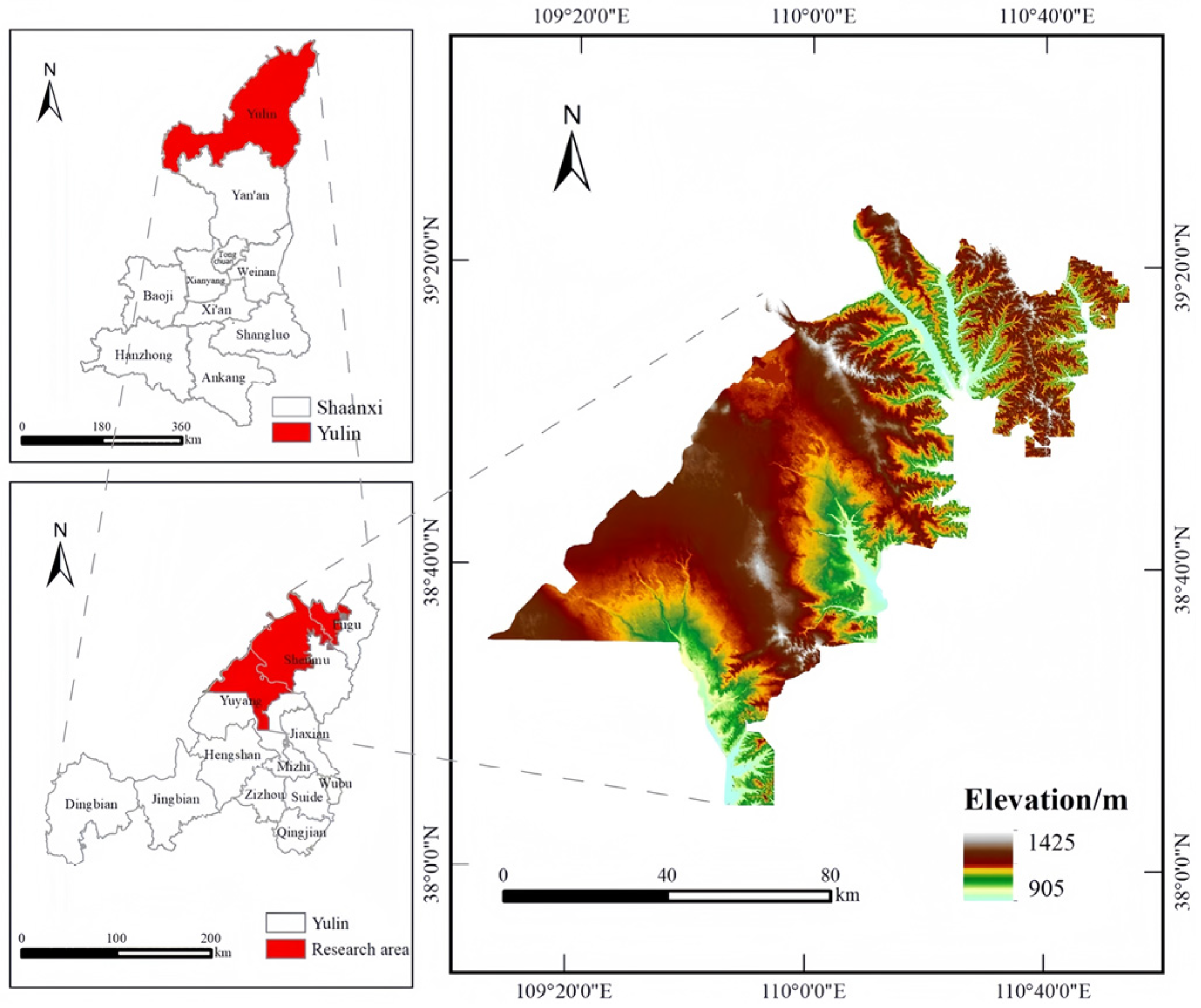
2. Overview of the Study Area

The study area is located in the loess hilly and gully area in Yulin City, northern Shaanxi Province. The ridges and hills are undulating, and the valleys are vertical and horizontal [29]. The slope gradient on both sides of the valley is generally within 5°~45° (Figure 1). The region belongs to the semi-arid continental climate, with perennial drought and little rain. The rainfall is concentrated from July to September, and the annual rainfall is between 194.7 mm and 531.6 mm. The ecological environment in the study area is fragile, the vegetation type is single, mainly drought-tolerant sand plants and shrubs, and the anti-interference ability is poor. The soil erosion in the area is serious, and the soil erosion modulus exceeds 4000 t·km−2·a−1 [30]. The strata in the study area from old to new are the Upper Triassic Yongping Formation (T3y), the Lower Jurassic Fuxian Formation (J1f), the Middle Jurassic Yan’an Formation (J2y), the Zhiluo Formation (J2z), the Anding Formation (J2a), and the Tertiary and Quaternary periods. Among them, the 2−2 coal seam in the Yan’an Formation is the main mineable coal seam in the area, with a thickness of 3~10 m, generally buried at a depth of 0~300 m [31]. The overlying bedrock is characterized by sand–mudstone interbedding. Among them, there are many layers of sandstone, generally 12 layers; the thickness of single-layer sandstone is about 14 m, and the sand/mud ratio is about 80%. The mining method of the main coal seam is long-wall comprehensive mechanized mining, and the mining thickness is generally about 5 m.

3. Research Method and Process

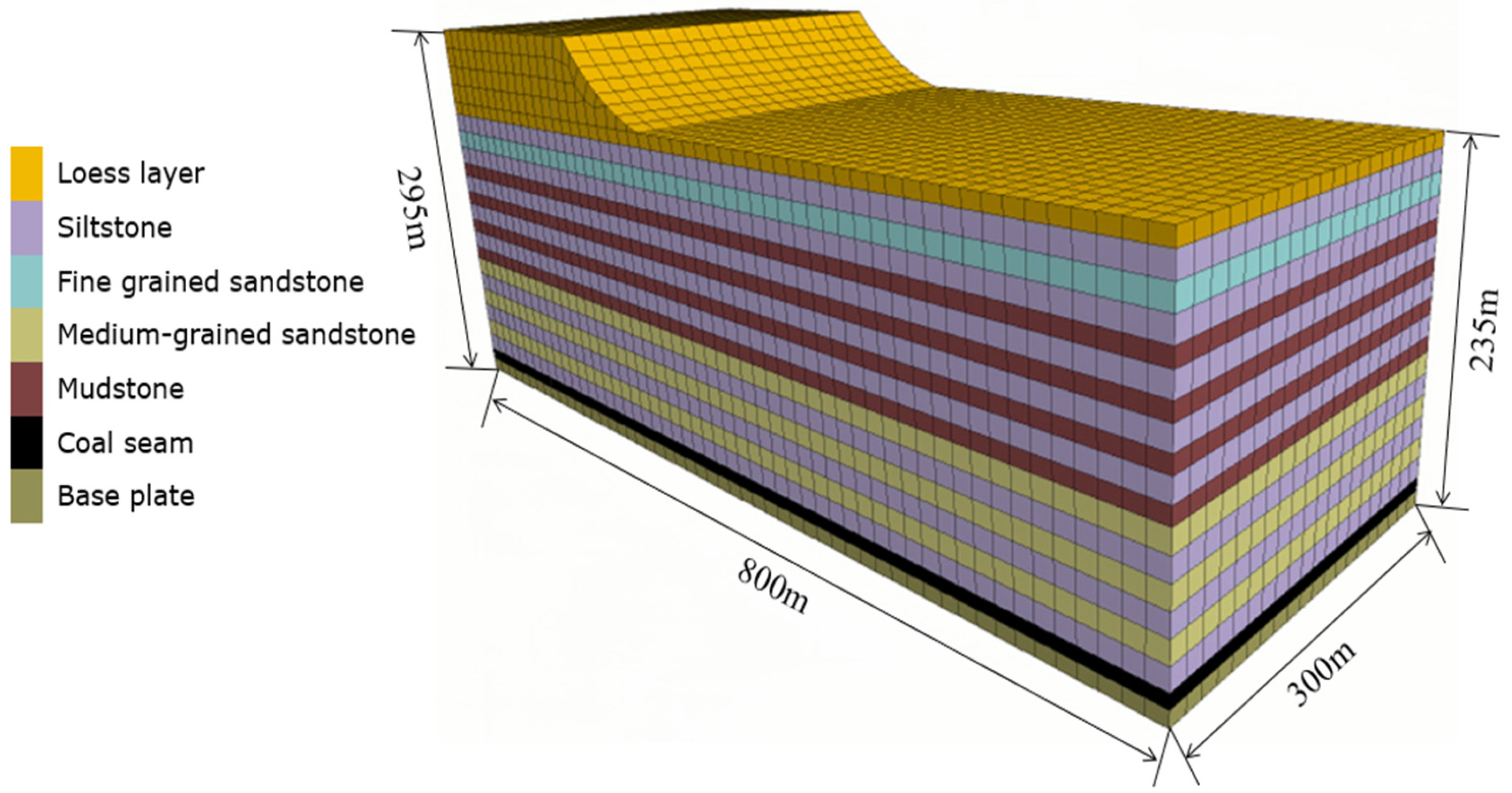
3.1. Numerical Model Construction and Experiment

In this study, FLAC3D version 6.0 was selected as the numerical simulation software, mainly because of its powerful three-dimensional geological modeling and geotechnical mechanics simulation capabilities. FLAC3D (Fast Lagrangian Analysis of Continua in 3 Dimensions) adopts the explicit finite difference method, which can effectively simulate the progressive failure and instability process of geological materials and is especially suitable for simulating the surface deformation caused by coal mining subsidence. It shows good adaptability in the dynamic simulation of surface displacement and related geological response caused by coal mining subsidence and can accurately reveal the change law of slope morphology and its relationship with coal mining subsidence. In addition, FLAC3D supports dynamic adjustment of local material parameters and can flexibly simulate different engineering processes according to specific geological conditions and mining conditions. Its efficient three-dimensional modeling, flexible parameter modification and powerful post-processing function can extract displacement, stress, and strain data in real time and generate an intuitive and clear displacement field and stress distribution chart, which provides strong support for the study of the slope deformation law. As a widely recognized numerical simulation tool for geotechnical engineering at home and abroad, FLAC3D has achieved remarkable results in a number of studies on coal mining subsidence and surface deformation [32,33]. However, the material model assumption of FLAC3D is relatively simplified, which may not fully reflect the complex nonlinear deformation behavior of a loess layer. Further experimental verification and model adjustment are needed to optimize the simulation results.

3.1.1. Model Framework

According to the morphological characteristics of the loess slope in the study area and the burial structure of the 2−2 main coal seam from the bottom to the top ‘floor-coal seam-bedrock layer-loess layer’, a three-dimensional geological numerical model was constructed. The natural slope shape of the loess slope in the model is set to four types: linear, concave, convex, and compound. These types are based on the classification criteria of slope shape and cover all kinds of slope shapes in the study area. The natural slopes of the loess slope are set to 5°, 15°, 25°, 35°, 45°, and 5 other gradients [34], which can cover the slope range in the study area. The model is set to be 800 m long, 300 m wide, and 295 m high at the top of the slope, and 235 m high at the foot of the slope. Among them, the thickness of the coal seam is 5 m, the thickness of the floor is 10 m, the thickness of the bedrock is 210 m, and the thickness of the loess layer is 70 m (including 10 m of loess layer in the horizontal section of the slope toe). The overlying bedrock of the coal seam is mainly sandstone and mudstone, and the thickness of the sandstone and mudstone is generally 80% and 20%. The upper part of the bedrock is siltstone and fine sandstone, the middle part is siltstone and mudstone, and the lower part is the interbedded structure of the medium sandstone and siltstone. Among them, there are 12 layers of sandstone with an average thickness of 14 m, and 4 layers of mudstone with an average thickness of 10.5 m. The typical three-dimensional geological model based on FLAC3D software is shown in Figure 2.

3.1.2. Model Type Division

Different types of numerical models are constructed with the natural slope shape and slope of the surface loess slope as variables. In order to ensure that the relative position of the surface loess slope and the underground goaf in all the models is consistent, the slope length under the coupling of different slope shapes and slopes is set to different lengths. Based on the above variables, a total of 20 different types of numerical models were constructed under the same mining and geological conditions (Table 1).

3.1.3. Simulation Test Process

First, according to the physical and mechanical test data of the rock and soil layers of representative geological boreholes in the study area, the parameters of each numerical model are assigned (Table 2); second, the boundary conditions of each numerical model are set in the FLAC3D version 6.0 software. The front, rear, left, and right interfaces of the model are unidirectional constrained boundaries; the lower boundary is a fully constrained boundary, and the upper interface is a free boundary. Third, the initial equilibrium of each numerical model is achieved by running the calculation; fourth, the gradual excavation test is carried out for each numerical model, and 20 m is excavated at each step until full mining is achieved. Fifth, the amount of subsidence and horizontal movement of the model surface slope that reaches the full mining state is extracted.

3.2. Calculation and Data Processing Method

3.2.1. Calculation of Morphological Parameters of Subsidence Slope

The equivalent substitution method is used to transform the subsidence and horizontal movement of the subsidence slope in the model into the slope shape, and the slope gradient and slope length are calculated [35].

3.2.2. Calculation of Soil Erosion Modulus

(1) Under the annual erosion rainfall scale
The Chinese General Soil Loss Equation (CSLE) proposed by Liu et al. [36,37] is adopted. The equation is based on the USLE (Universal Soil Loss Equation) and RUSLE (Revised Universal Soil Loss Equation) models in the United States and is combined with the characteristics of soil erosion and soil slope characteristics in China. It is suitable for predicting and calculating soil erosion intensity in China. Since the calculation results of the CSLE model are more in line with the actual situation in China, it has been adopted by the ‘Soil Erosion Classification and Grading Standard’ (SL190-2007) and has become a recommended method for calculating the soil water erosion modulus at the annual erosion rainfall scale. Therefore, many scholars at home and abroad [38,39] have carried out research on soil erosion in different types of regions based on this equation, including coal mining areas in the northwest. For example, Wang et al. [40] studied the dynamic changes in soil erosion in the Shendong mining area using this model. In view of this, the CSLE equation is more suitable for the study of soil erosion characteristics and the change rules in the loess coal mining subsidence area in northern Shaanxi. In the CSLE model formula, the rainfall erosivity factor was based on that of Hu Lin et al. [41], and the R in northern Shaanxi was 1471.4 MJ·mm·hm−2h−1a−1. The soil erodibility factor is combined with the calculation method proposed by Williams et al. [42] and the study of Song et al. [43] on the soil erodibility of the loess slope in northern Shaanxi. The soil erodibility K value is 0.306 t·hm2·h·(MJ·hm2·mm)−1; the slope length and slope factor (L, S) were calculated by the formula proposed by Desme et al. [44] and McCool D K et al. [45,46]. The vegetation coverage and biological measures factor B was obtained by the vegetation coverage equation proposed by Cai Chongfa et al. [47]. The factor E of soil and water conservation engineering measures was selected as 0.9, and the factor T of tillage measures was set as 1.
(2) Typical erosion rainfall scale
The empirical formula of Wu et al. [48] is based on the long-term rainfall erosion characteristics, slope morphology, and soil erosion dynamics in the Loess Plateau. After many field verifications, it is widely used in soil erosion analysis in the Loess Plateau and other erosion sensitive areas. The formula can effectively predict soil loss under different rainfall conditions by quantifying the interaction between rainfall, slope, slope length, and soil erosion. In this paper, three typical rainfall conditions (16.6 mm, 26.9 mm, 39.7 mm) in the empirical formula of Wu et al. were selected, and the soil erosion modulus was calculated by combining slope and slope length, as shown in Table 3. In the analysis of the model, It is understood that the main erosive rainfall in the Loess Plateau of northern Shaanxi is concentrated within the range of 15 to 45 mm. Rainfall within this range occurs frequently, accounting for 50-65% of the annual precipitation events, and the runoff generated from this rainfall contributes to 81.7% of the total runoff. It is proved that the application of the formula under this rainfall condition is reasonable, and it has good applicability to the typical erosive rainfall area of the Loess Plateau in northern Shaanxi. It should be noted that Wu’s empirical formula is widely used in the Loess Plateau, but the model is mainly based on empirical data, which may not fully capture soil erosion under complex terrain or extreme weather conditions. Therefore, when applied in other regions, it may be necessary to make appropriate adjustments to the model.
(3) Calculation of the contribution of slope factor and slope length factor in soil erosion modulus
The contribution of slope factor and slope length factor to the soil erosion modulus was quantitatively analyzed by using the coefficients of each variable in the multivariate linear regression equation. The size and positive and negative values of the coefficient reflect the positive or negative effects of each factor on the soil erosion modulus, so as to clarify its importance in the process of soil erosion.

4. Results

Based on the numerical simulation test and data calculation, the slope, slope length, and soil erosion modulus of the surface loess slope of the 20 models before and after mining were obtained, respectively, as shown in Table 4.

4.1. The Influence of Coal Mining Subsidence on the Slope of Loess Slope

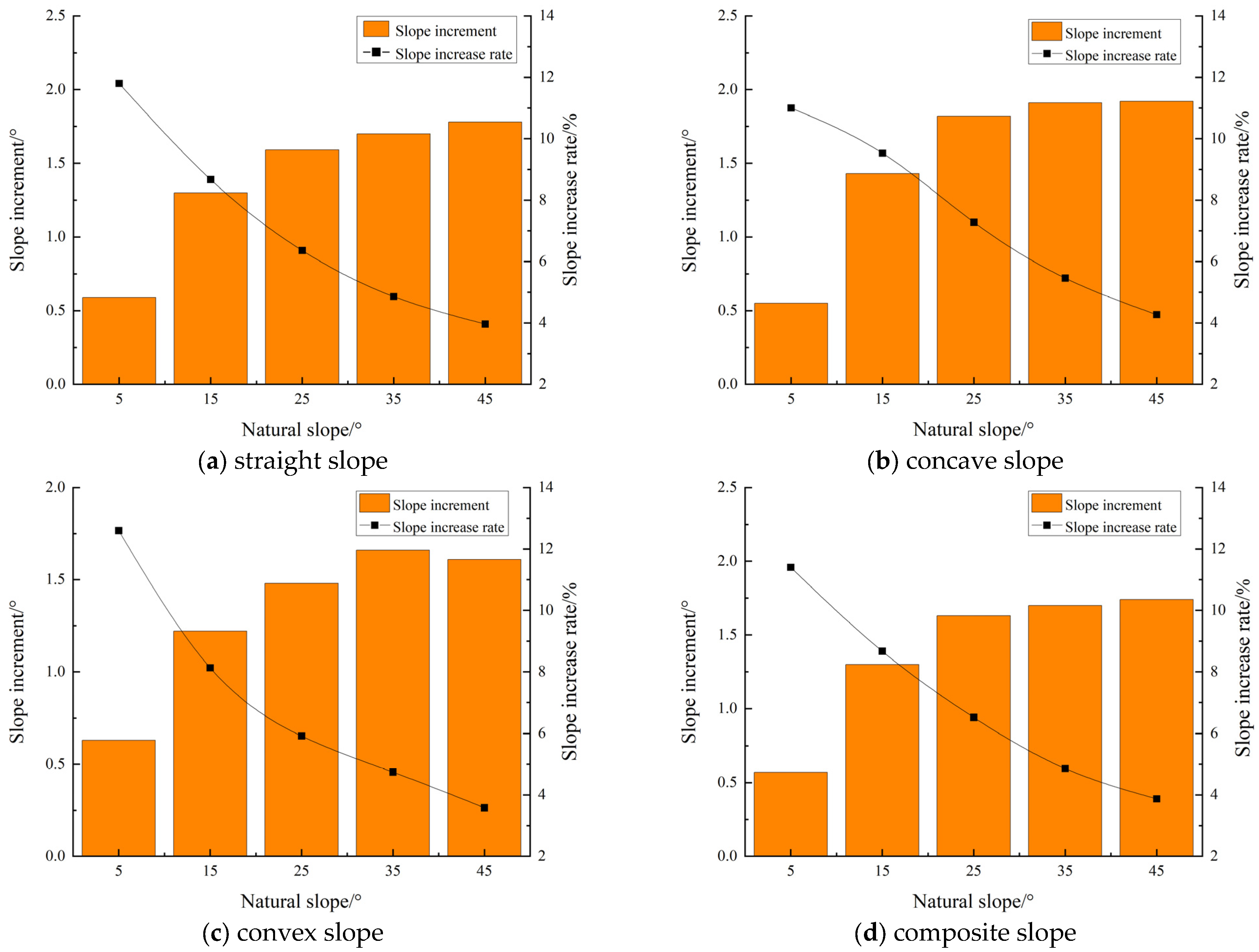
4.1.1. Slope Variation Characteristics of Subsidence Slope Under the Same Natural Slope Shape

According to Table 4, the contrast diagram of the increment of and increase in the slope of the loess slope after coal mining subsidence under the same natural slope condition is drawn; this is shown in Figure 3.
First, under the condition of full mining, when the natural slope is [5°, 25°], the slope increments of the linear, concave, convex, and complex loess slopes increase with the increase in the slope. Among them, the concave loess slope has the largest slope increment when the natural slope is 25°, which is 1.27 times, 1.49 times, and 1.20 times that of the linear, convex, and complex slopes. When the natural slope is (25°, 45°], the change range of the slope increments of these four loess slopes is small, and the change value of the increments is within 0.1°. In general, coal mining subsidence will lead to the slope increments of linear, concave, convex, and complex loess slopes increasing first and then tending to be stable with the increase in natural slope. Secondly, under the condition of full mining, when the natural slope is [5°, 15°), the average increase in the slope gradient of the linear, concave, convex, and composite loess slopes is more than 10%, and the increase in the slope gradient of the convex loess slope is the largest when the natural slope is 5°, with an increase of more than 12%. When the natural slope is (15°, 25°], the average increase in the slope gradient of the linear, concave, convex, and composite loess slopes is 7.51%, 8.41%, 7.03%, and 7.59%, respectively. When the natural slope is (25°, 45°], the average increase in the slope of the linear, concave, convex, and composite loess slopes is 5.01%, 5.62%, 4.75%, and 5.03%, respectively. Among them, the slope of the three loess slopes of the linear, convex, and composite shapes is increased by less than 4% when the natural slope is 45°. It can be seen that coal mining subsidence will lead to the increase in the slope of the four slope shapes, which decreases with the increase in the natural slope. When the natural slope is 5°, the increase in the slope of the four slope shapes is the largest, and the change trend is highly consistent with the exponential function, as shown in Equations (1)–(4).
Slope   increase   equation   of   straight   slope :   C i = 13.159 e 0.028 i             R 2 = 0.9938
Slope   increase   equation   of   concave   slope :   C i = 13.064 e 0.025 i             R 2 = 0.9894
Slope   increase   equation   of   convex   slope :   C i = 13.650 e 0.031 i             R 2 = 0.9844
Slope   increase   equation   of   complex   slope :   C i = 13.016 e 0.027 i             R 2 = 0.9985
In the equation: i —The natural slope of four kinds of slope shape loess slope, °; C i —Slope increase, %.

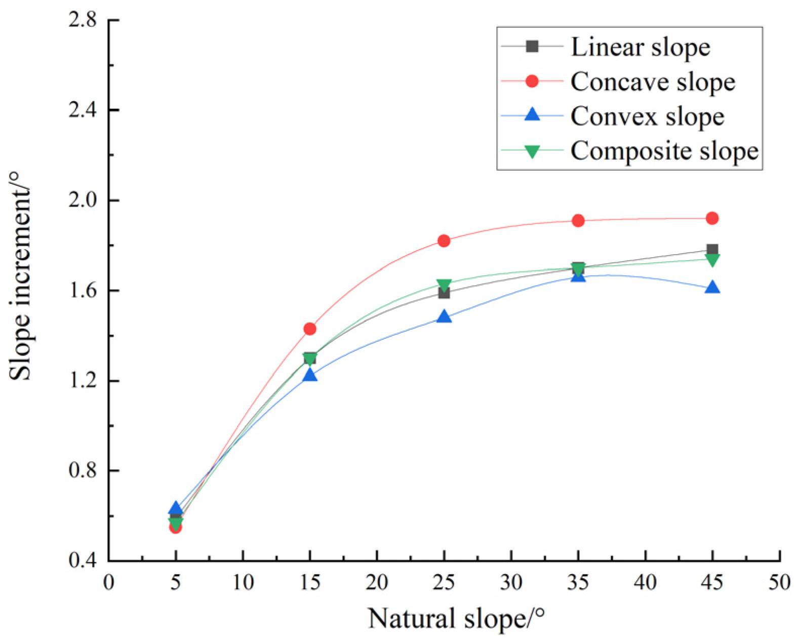
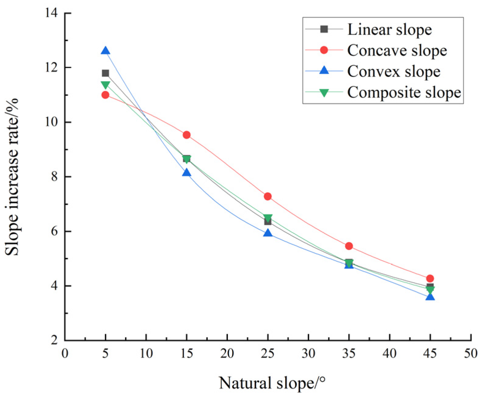
4.1.2. Slope Variation Characteristics of Subsidence Slope Under the Same Natural Slope

According to Table 4, the curve of the slope gradient increment of and increase in the loess slope with the linear, concave, convex, and compound shapes after coal mining subsidence under the same natural slope condition is drawn; this is shown in Figure 4 and Figure 5.
It can be seen from Figure 4 and Figure 5 that under the same natural slope, the influence of coal mining subsidence on the slope of linear, concave, convex, and complex loess slopes is different. Specifically:
Firstly, under the condition of full mining, when the natural slope is [5°, 15°), the slope increments of the linear, concave, convex, and composite loess slopes are all below 0.7°, and there is no significant difference. When the natural slope is [15°, 45°], the slope increment of these four loess slopes is between 1.2° and 2°. Among them, the slope increment of the concave loess slope is always the largest, which is 11.11%, 11.86%, and 11.11% higher than that of the linear, convex, and composite slopes, respectively. It can be seen that the influence of coal mining subsidence on the slope of the concave loess slope is the most significant. Secondly, under the condition of full mining, when the natural slope is [5°, 15°), the slope increase of the linear, concave, convex, and composite loess slopes is the largest, which is more than 10%. The order of the slope increase of the loess slopes with different slope shapes caused by coal mining subsidence is convex slope > linear slope > composite slope > concave slope. When the natural slope is [15°, 45°], the order of the slope increase of the loess slope under different slope shapes caused by coal mining subsidence is concave slope > straight slope ≈ composite slope > convex slope. The slope increase of the concave loess slope is 11.32%, 18.61%, and 10.99% higher than that of the straight, convex, and composite slopes, respectively.
It can be seen, firstly, that the convex loess slope with a natural slope of less than 15° and the concave loess slope with a natural slope of greater than 15° are the most sensitive to coal mining subsidence. Second, the natural slope of 15° is the key demarcation point for the transformation of the sensitive slope shape of the loess slope in the coal mining subsidence area of northern Shaanxi.

4.2. The Influence of Coal Mining Subsidence on Slope Length of Loess Slope

4.2.1. The Variation Characteristics of Slope Length of Subsidence Slope Under the Same Natural Slope Shape

According to Table 4, the comparison chart of the reduction and the change in the slope length of the loess slope after the mining subsidence under the same natural slope condition is drawn; this is shown in Figure 6.
It can be seen from Figure 6 that no matter what kind of slope shape, coal mining subsidence will lead to the decrease in the slope length of the loess natural slope, and the smaller the natural slope, the greater the decrease in slope length. Specifically:
Firstly, under the condition of full mining, when the natural slope is [5°, 15°), the average decrease in the slope length of the linear, concave, convex, and composite loess slopes is 3.44%, 5.09%, 2.82%, and 4.75%, respectively. When the natural slope was [15°, 25°), the average decrease in the slope length of the four loess slopes was 3.10%, 4.72%, 2.62%, and 4.18%, respectively. When the natural slope was [25°, 35°), the average decrease in the slope length of the four loess slopes was 2.86%, 3.84%, 2.27%, and 3.50%, respectively. When the natural slope is [35°, 45°], the average decrease in the slope length of these four loess slopes is 2.06%, 2.44%, 1.51%, and 2.11%, respectively. It can be seen that coal mining subsidence will lead to the decrease in the slope length of the loess slope with the increase in the natural slope. Secondly, under the condition of full mining, the slope length of the linear, concave, convex, and composite loess slopes with a natural slope of 5° has the largest decrease, which is 1.44 times, 1.47 times, 1.43 times, and 1.63 times that of the average decrease in the slope length of the four slopes with a natural slope of 15°, 25°, 35°, and 45°. It can be seen that the influence of coal mining subsidence on the slope length of the loess slope is the most obvious when the natural slope is 5°, and its change trend conforms to the characteristics of a quadratic polynomial function, as shown in Equations (5)–(8).
The   slope   length   reduction   amplitude   equation   of   straight   slope :   L i = 0.0011 i 2 + 0.0048 i + 3.597             R 2 = 0.9394
The   slope   length   reduction   amplitude   equation   of   concave   slope :   L i = 0.0022 i 2 + 0.023 i + 5.1784               R 2 = 0.9929
The   slope   length   reduction   amplitude   equation   of   convex   slope :   L i = 0.0013 i 2 + 0.0196 i + 2.8265               R 2 = 0.9873
The   slope   length   reduction   equation   of   composite   slope :   L i = 0.0019 i 2 + 0.0025 i + 5.0356               R 2 = 0.9836
In the equation: i —The natural slope of four kinds of slope shape of loess slope, °; L i —Reduction in slope length, %.

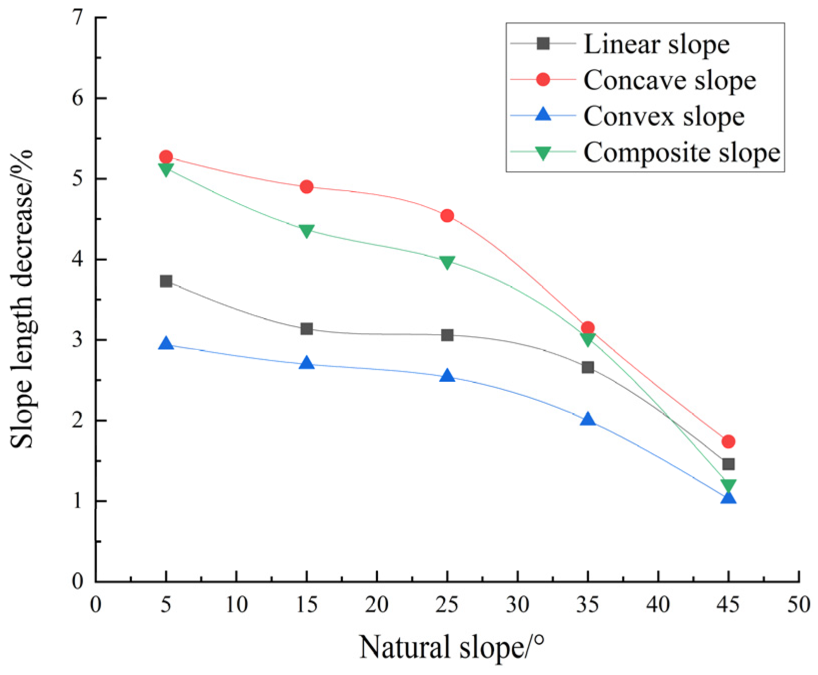
4.2.2. The Variation Characteristics of Slope Length of Subsidence Slope Under the Same Natural Slope

According to Table 4, under the same natural slope conditions, the curves of the decrease and decrease in the slope length of the loess slope after mining subsidence are drawn and are straight, concave, convex, and composite. See Figure 7 and Figure 8.
It can be seen from Figure 7 and Figure 8 that under the same natural slope, the influence of coal mining subsidence on the slope length of the linear, concave, convex, and composite loess slopes is different. Specifically:
Firstly, under the condition of full mining, when the natural slope is [5°, 25°], the average decrease in the slope length of the linear, concave, convex, and compound loess slopes caused by mining subsidence is 3.31%, 4.90%, 2.73%, and 4.49%, respectively. The order of the slope length decrease of the loess slope under different slope shapes is concave slope > compound slope > linear slope > convex slope. Among them, the decrease in the slope length of the concave loess slope is always the largest, which is 1.48 times, 1.80 times, and 1.09 times that of the average decrease in the slope length of the linear, convex, and compound loess slopes. When the natural slope is (25°, 45°], the order of the slope length reduction of the loess slope under the different slope shapes caused by coal mining subsidence is concave slope > composite slope ≈ straight slope > convex slope. It can be seen that the influence of coal mining subsidence on the slope length of the concave loess slope is the most significant.
Second, under the condition of full mining, when the natural slope is [5°, 25°], the slope length of the three loess slopes of the linear, concave, and convex slopes is relatively stable, and the variation range is below 0.8%. When the natural slope is (25°, 45°], the slope length of the linear, concave, convex, and composite loess slopes changes significantly, and the slope length of these four loess slopes with a natural slope of 25° is 2.10 times, 2.61 times, 2.47 times, and 3.28 times that of 45°. It can be seen, firstly, that the decrease in the slope length of the loess subsidence slope under different slope shapes shows a decreasing trend with the increase in natural slope. Second, the natural slope of 25° is the key point of the sudden change rate of the slope length of the loess slope in the coal mining subsidence area of northern Shaanxi.

4.3. Analysis of Soil Erosion Effect of Slope Deformation

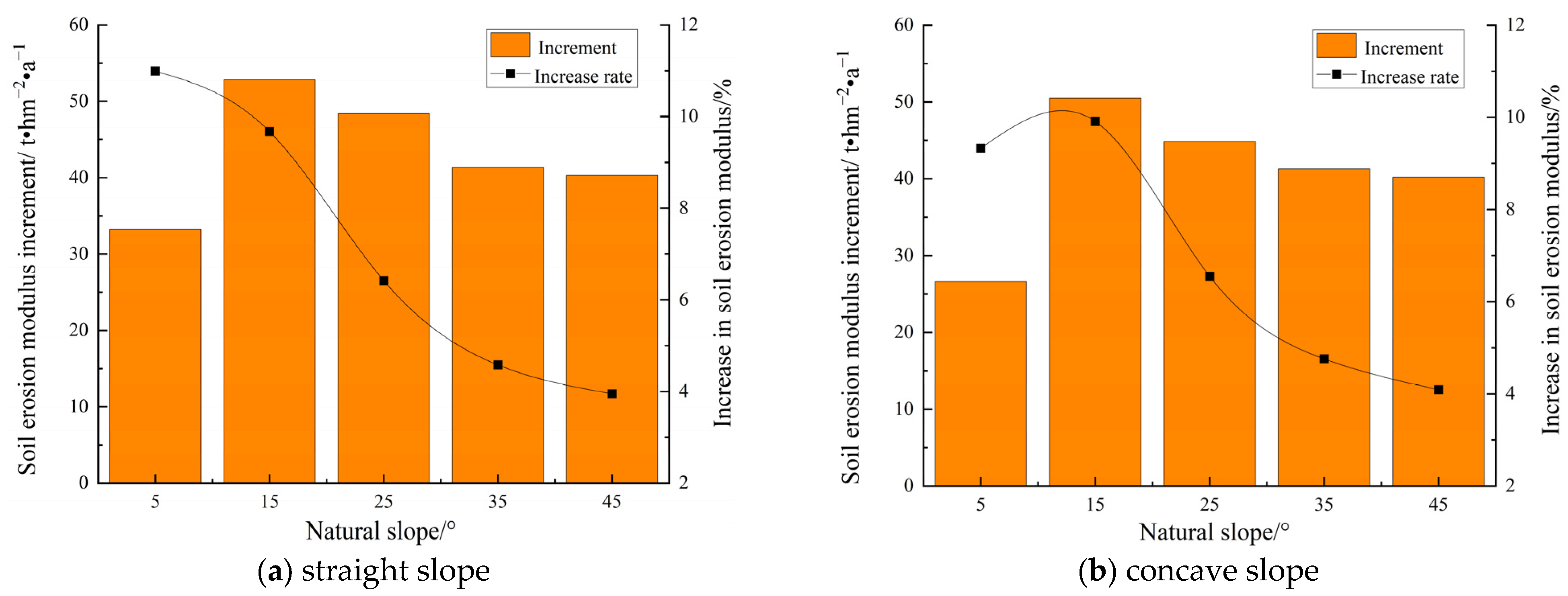
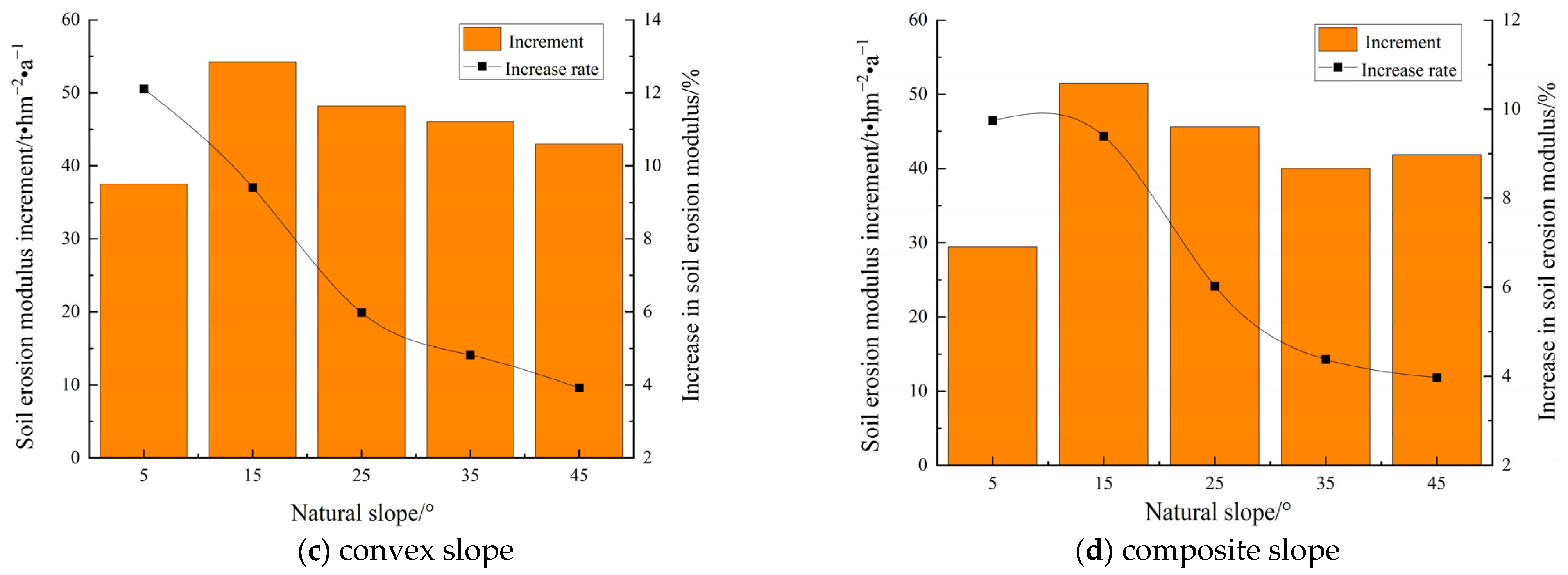
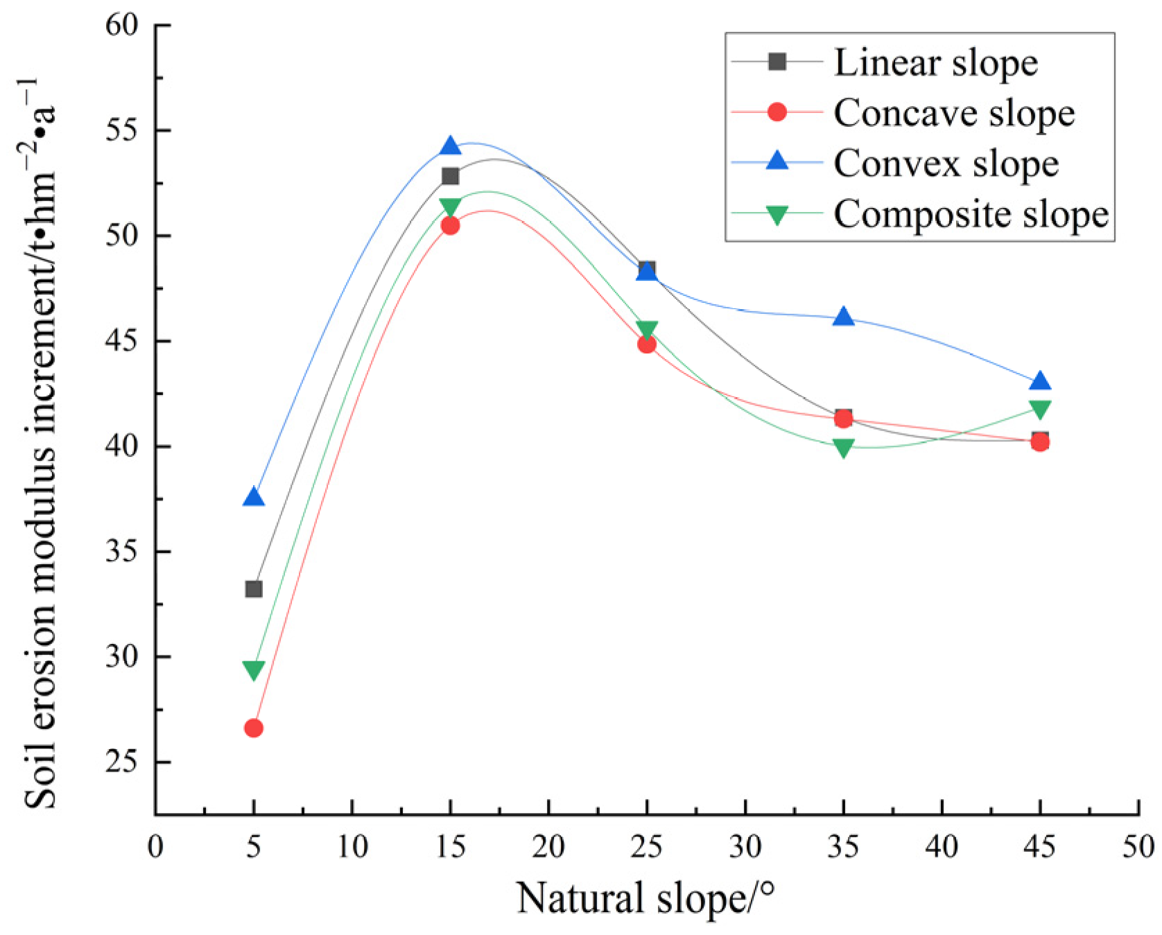
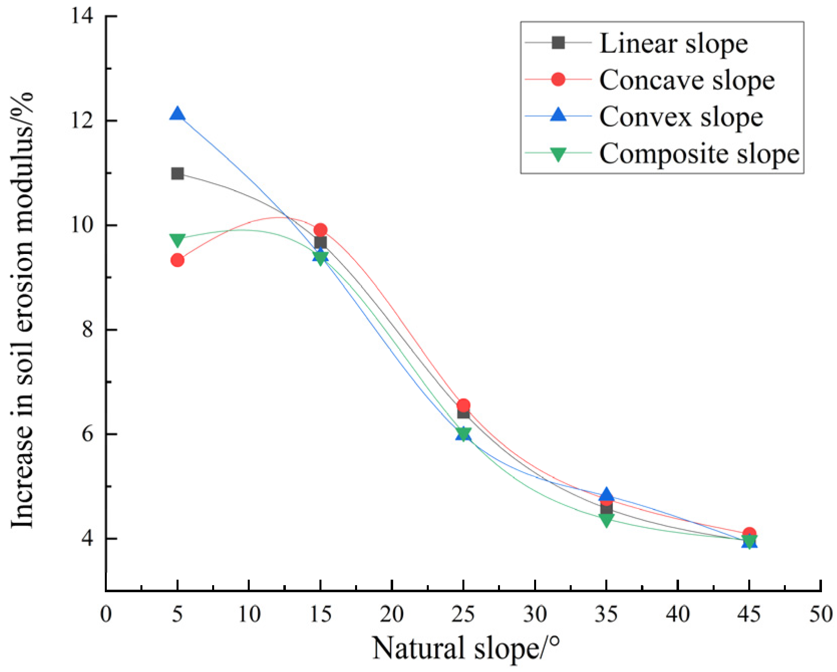
4.3.1. Soil Erosion Effect Under Annual Erosion Rainfall Scale

(1) The variation characteristics of soil erosion modulus under the same natural slope shape
According to Table 4, the contrast diagram of the increment of and increase in the soil erosion modulus of the loess slope with the same natural slope shape after coal mining subsidence under the annual erosion rainfall scale is drawn; this is shown in Figure 9.
From Figure 9, it can be seen that no matter what the slope shape, coal mining subsidence will lead to an increase in the soil erosion modulus on the loess slope. Specifically:
First, under the condition of full mining, when the natural slope is [5°, 15°], the average increase in the soil erosion modulus of the linear, concave, convex, and composite loess slopes is 10.33%, 9.62%, 10.76%, and 9.56%, respectively. When the natural slope is (15°, 25°), the average increase in the soil erosion modulus of these four loess slopes is 6.42%, 6.55%, 5.98%, and 6.03%, respectively. When the natural slope was (25°, 45°], the average increase in the soil erosion modulus of the four loess slopes was 4.26%, 4.43%, 4.37%, and 4.18%, respectively. In addition, the increment of the soil erosion modulus of the linear, concave, convex, and complex loess slopes with a natural slope of 15° is the largest, which is 1.67 times, 1.12 times, 1.24 times, and 1.26 times that of the average increment of the soil erosion modulus of the four slopes with natural slopes of 5°, 25°, 35°, and 45°.
Second, according to the data of the slope increase, slope length decrease, and soil erosion modulus increase of the loess slope in different models, the quantitative relationship between the soil erosion modulus increase ( R M 1 ) and slope increase ( R s ) and slope length decrease ( R l ) under the annual erosion rainfall scale was constructed by using a multiple linear fitting method, as shown in Equation (9).
R M 1 = 1.007 R s 0.279 R l + 0.644             R 2 = 0.9325
In the formula: R M 1 —The increase in soil erosion modulus under the scale of one-year erosion rainfall, %; R s —slope gradient increase, %; R l —slope length decrease, %.
It can be seen, firstly, that under the scale of annual erosion rainfall, the increase in the soil erosion modulus of the loess subsidence slope with any slope shape shows a decreasing trend with the increase in natural slope. Secondly, the natural slope of 15° is the key point of the abrupt change in soil erosion intensity on the loess slope of the coal mining subsidence area in northern Shaanxi under the annual erosion rainfall scale. Thirdly, under the scale of annual erosion rainfall, the increase in the slope gradient has a positive effect on the increase in the soil erosion modulus, and the decrease in the slope length has a negative effect on the increase in the soil erosion modulus. The contribution of the slope increase was 92.9%, and the contribution of the slope length decrease was 7.1%. Therefore, the increase in the slope is the main factor of the increase in the soil erosion modulus.
(2) The variation characteristics of soil erosion modulus under the same natural slope angle According to Table 4, the curve of the soil erosion modulus increment of and the increase in the linear, concave, convex, and composite loess slopes with the same natural slope after coal mining subsidence under the annual erosion rainfall scale is drawn; this is shown in Figure 10 and Figure 11.
It can be seen from Figure 10 and Figure 11 that under the same natural slope, the influence of coal mining subsidence on the soil erosion modulus of the linear, concave, convex, and complex loess slopes is different. Specifically:
First, under the condition of full mining, when the natural slope is [5°, 15°), the average increase in the soil erosion modulus of the linear, concave, convex, and composite loess slopes is 10.99%, 9.33%, 12.11%, and 9.74%, respectively. Among them, the increase in the soil erosion modulus of the convex loess slope is the largest, which is 1.10 times, 1.30 times, and 1.24 times of that of the linear, concave, and composite loess slopes. When the natural slope is [15°, 45°], the average increase in the soil erosion modulus of the linear, concave, convex, and composite loess slopes is 9.60%, 6.25%, 4.64%, and 3.98%, respectively. Under the same slope condition, there is no significant difference in the increase in the soil erosion modulus among the four slopes. It can be seen that under the annual erosion rainfall scale, coal mining subsidence has the most significant effect on the increase in the soil erosion modulus of the convex loess slope with slope < 15°.

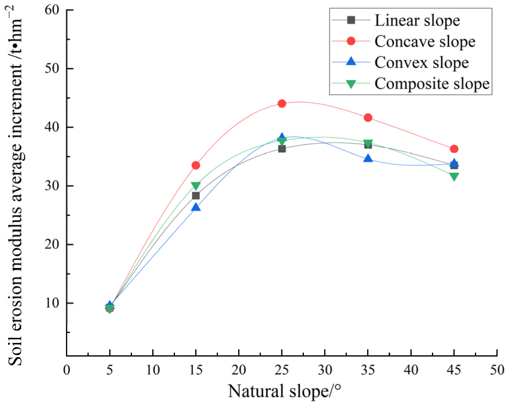
4.3.2. Soil Erosion Effect Under Typical Field Erosion Rainfall Scale

(1) The variation characteristics of soil erosion modulus under the same natural slope shape
According to Table 4, the average increment of and average increase in the soil erosion modulus of the loess slope with the same natural slope shape after coal mining subsidence were compared under the typical rainfall scale of erosion, as shown in Figure 12.
From Figure 12, it can be seen that coal mining subsidence will lead to an increase in soil erosion modulus on loess slopes under all slope shape and rainfall conditions, and the smaller the natural slope, the greater the increase in soil erosion modulus. Specifically:
Firstly, under the condition of full mining, when the natural slope is [5°, 25°], the average increase in the soil erosion modulus of the linear, concave, convex, and composite loess slopes under three typical erosive rainfall conditions is 8.80%, 9.60%, 8.88%, and 9.11%, respectively, and the increase in the soil erosion modulus is the largest when the natural slope is 25°, which is 3.93 times, 4.85 times, 4.00 times, and 4.13 times that of the increase in the soil erosion modulus when the natural slope is 5°. When the natural slope is (25°, 35°], the average increase in the soil erosion modulus of the linear, concave, convex, and composite loess slopes under three typical erosive rainfall conditions is 5.44%, 6.28%, 5.52%, and 5.64%, respectively. The average increment of the soil erosion modulus of the loess slopes with any slope shape in this natural slope range is not much different from that of the natural slope of 25°, and the average increment is not more than 1.5 t·hm−2. When the natural slope is (35°, 45°], the average increase in the soil erosion modulus of the linear, concave, convex, and composite loess slopes under three typical erosive rainfall conditions is 3.82%, 4.19%, 3.73%, and 3.79%, respectively. In this natural slope range, the average increase in the soil erosion modulus of the loess slope with any slope shape is slightly lower than that of the natural slope of 35°, and the average decrease is not more than 3.9 t·hm−2.
Secondly, according to the data of the slope increase, slope length decrease, and soil erosion modulus increase of the loess slope in the different models, the quantitative relationship between the soil erosion modulus increase ( R M 2 ) and slope increase ( R s ) and slope length decrease ( R l ) under a typical erosion rainfall scale was constructed by using the multiple linear fitting method, as shown in Equation (10).
R M 1 = 1.007 R s 0.279 R l + 0.644 R 2 = 0.9325
In the formula: R M 2 —The increase in soil erosion modulus under typical field erosion rainfall scale, %; R s —Slope gradient increase, %; R l —Slope length decrease, %.
It can be seen, firstly, that under the typical rainfall scale of erosion, the increment of the soil erosion modulus of the loess subsidence slope with an arbitrary slope shape increases first and then decreases with the increase in the natural slope. Secondly, the natural slope of 25° is the key point of the abrupt change in soil erosion intensity on the loess slope in the coal mining subsidence area of northern Shaanxi under the typical erosion rainfall scale. Thirdly, under the typical rainfall scale of erosion, the increase in slope and the decrease in slope length have a positive effect on the increase in the soil erosion modulus. The contribution of the slope increase is 79.1%, and the contribution of the slope length decrease is 20.9%. Therefore, the increase in the slope is the main factor of the increase in the soil erosion modulus.
(2) The variation characteristics of soil erosion modulus under the same natural slope angle
According to Table 4, the curves of the average increment of and average increase in the soil erosion modulus of the linear, concave, convex, and compound loess slopes with the same natural slope after coal mining subsidence under a typical rainfall scale are drawn, as shown in Figure 13 and Figure 14.
It can be seen from Figure 13 and Figure 14 that under the same natural slope and three typical rainfall conditions, the influence of coal mining subsidence on the soil erosion modulus of the linear, concave, convex, and complex loess slopes is different. Specifically:
First, under the condition of full mining, when the natural slope is [5°, 15°), the average increase in the soil erosion modulus of the linear, concave, convex. and composite loess slopes under three typical rainfall conditions is 10.01%, 10.63%, 9.92%, and 10.33%, respectively. In this slope range, the average increase in the soil erosion modulus of the concave and composite loess slopes did not change significantly, and the increase value was below 0.8%. When the natural slope is [15°, 45°], the average increase in the soil erosion modulus of the linear, concave, convex, and composite loess slopes under three typical rainfall conditions is 9.63%, 6.85%, 4.59%, and 3.18%, respectively. In this slope range, the average increase in the soil erosion modulus of the loess slopes under different slope shapes is concave slope > composite slope ≈ linear slope ≈ convex slope. It can be seen that under the typical rainfall scale of erosion, the influence of coal mining subsidence on the average increase in the soil erosion modulus on the concave loess slope is the most obvious.

5. Discussion

5.1. Effects of Slope Gradient on Stability and Deformation of Loess Slope

Slope gradient is closely related to slope stability, and it is generally believed that the greater the slope, the worse the stability of the slope. Kokutse et al. [49] pointed out that the effect of the slope on slope stability is primarily achieved by altering the cohesion of the soil, and that different slopes play a crucial role in the variation in the safety factor. Zhang et al. [50] found that the slope gradient is closely related to stability. The unstable slope gradient is mostly concentrated above 35°, and the increase in slope gradient will change the stress distribution and reduce the slope safety factor. Zhu Boliang et al. [51] quantitatively calculated 76 loess slope models through the geotechnical slope stability analysis system. The results show that the increase in slope significantly reduces the stability coefficient of the loess slope, especially when the slope is less than 55°, the slope stability coefficient decreases sharply. Katz et al. [52] studied the negative effects of slope on slope stability and deformation from the perspective of numerical simulation and verified that the larger the slope, the larger the slope movement size, which in turn leads to the worse slope stability. Haijun Qiu et al. [53] used a combination of remote sensing images and field surveys. This study revealed the complex relationship between slope and slope movement size and further explained the influence of slope on loess slope deformation. Xi et al. [54] extracted the slope information of a coal mining subsidence area by using the digital image and multi-period digital elevation model (DEM) obtained by UAV and found that coal mining subsidence would lead to the overall increase in surface slope. Based on the law and model of mining subsidence, Huang et al. [55] studied the change in loess slope in a coal mining subsidence area through digital elevation model analysis and remote sensing image processing technology and found that coal mining subsidence led to the shortening of the surface slope length factor. This finding and the results of this study show that coal mining subsidence not only leads to the increase in surface slope, but also causes the shortening of slope length, which affects the change in slope morphology. In addition, this study also found that with the increase in the natural slope of the loess slope, the increase in the slope of the slope after the subsidence also increases, while the decrease in the slope length is relatively reduced, which provides a new research direction for the in-depth study of the law of slope movement and deformation in the subsidence area after coal mining.

5.2. Influence of Slope Shape on the Stability and Deformation Characteristics of Loess Slopes

The influence of slope shape on slope stability is still controversial in academia. Tang et al. [56] deeply explored the influence of different slope shapes on the stability of soil slopes through seismic simulation shaking table tests. The results show that the slope shape has a significant effect on the stability and deformation of the slope. The PGA (peak ground acceleration) amplification coefficient of the concave slope at the turning point of the slope is significantly higher than that of the convex slope and the straight slope, which makes the concave slope more prone to damage and deformation. Huang et al. [57] further confirmed the importance of slope shape to the stability and deformation of the loess slope through the combination of a small shaking table test and FLAC3Dnumerical simulation. Their study found that under dynamic loading, convex slopes are more prone to instability, while concave slopes show stronger stability. In addition, Sharma et al. [58] revealed the phenomenon whereby the pore water pressure of the concave slope increased under the action of precipitation through three-dimensional numerical simulation, which led to a significant increase in slope deformation and an increase in landslide risk, once again highlighting the important influence of slope shape on slope stability. On the other hand, Gao J et al. [59] found that the concave slope with a medium height and steep slope is more likely to move and deform by using the method of remote sensing interpretation, which provides new evidence for the influence of slope shape on slope stability. This study reveals the close relationship between slope shape and slope under the special dynamic load of coal mining subsidence. Specifically, under the influence of the same coal mining subsidence, when the natural slope does not exceed 5°, the convex slope shows the largest movement deformation; when the natural slope exceeds 5°, the deformation of the concave slope becomes the most significant. This finding provides a new perspective for understanding the stability and deformation characteristics of the surface loess slope in the coal mining subsidence area.

5.3. Influence of Coal Mining Subsidence on Soil Erosion

The surface movement and deformation caused by coal mining subsidence will significantly change the original topography of the region, where the change in slope shape (slope gradient and slope length) is the most prominent. Slope and slope length characteristics are the key topographic factors affecting slope soil erosion, which has been the general consensus in the field of soil and water conservation [60]. Slope gradient has been repeatedly studied and confirmed as a key topographic factor affecting slope runoff and soil erosion. Farhan Y [61] studied the correlation between soil erosion and the topographic unit and slope in a watershed in northern Jordan. It was found that the soil erosion intensity on the slope was highly correlated with the slope, especially in the slope of 15–25°. The intensity of soil erosion on the slope was significantly enhanced; Xu Zhenjian et al. [62] carried out indoor experiments on loessial soil in the Loess Plateau and adjusted the experimental soil bin to three slopes of 5°, 10°, and 20°. The study found that the slope can affect the total runoff and soil erosion by affecting the runoff. Under the condition of rainfall intensity of 1.5 mm min−1, the total erosion amount of the slope reached the maximum when the slope was 10°; Huang Jun et al. [63] conducted rainfall experiments on the typical red soil hilly area in the upper reaches of the Hanjiang River in the Pearl River Basin and used the PI10 index algorithm to calculate the rainfall erosion of each rainfall event. The study found that the soil erosion modulus variable and the slope under the condition of rainfall increased first and then decreased, and the critical slope value was about 10.75°. By selecting the typical small watershed of Qilong Bay in the middle and upper reaches of the Yellow River Basin as the research area, and based on the observation data of 10 runoff plots from 2008 to 2016, Wang Min et al. [64] analyzed that the amount of soil erosion increased with the increase in slope, and the amount of soil erosion was the largest when the slope was 30°. The above research results are highly consistent with the results of the study on the increase in slope gradient caused by coal mining subsidence under the scale of annual erosion rainfall and the scale of typical field erosion rainfall, which leads to the increase in the slope soil erosion modulus. It can be seen that no matter what the slope shape is, the greater the influence of the same coal mining subsidence on the loess slope with larger natural slope, the more obvious the change in slope after subsidence and the resulting change in soil erosion intensity on the slope.
As another important topographic factor, the effect of slope length on soil erosion is controversial. Liu Ran et al. [65] took the loess slope of Ansai in the loess hilly and gully region as the research object and studied the law of runoff and sediment yield on the loess slope under the two slope lengths of 5 m and 10 m through the indoor artificial simulated rainfall test. The results show that the increase in slope length will increase the rain-bearing area of the slope, resulting in an increase in the runoff rate per unit width and a corresponding increase in the total sediment yield. Therefore, the slope length and the slope erosion amount show a significant positive correlation. Based on the runoff and sediment yield data of eight runoff plots in Longfengling Soil and Water Conservation Science and Technology Demonstration Park in Mentougou District of Beijing from 2005 to 2009, Liu Dong et al. [66] concluded that slope length had a significant effect on runoff and sediment yield per unit area in a small runoff area and that the amount of soil erosion would increase with the increase in slope length. However, Kinnell [67] found that the slope length below 1 m has the effect of increasing soil erosion intensity through the rainfall erosion test of the plot below 10 m and the WEPP rill erosion model. However, with the increase in slope length, the energy of slope flow decreases, which leads to a decrease in soil erosion intensity. Based on the data of soil and water conservation monitoring points in Shiqiao small watershed, Gao et al. [68] studied the effect of slope length on soil erosion in karst slope farmland. The study showed that the soil erosion modulus increased with the increase in slope length when the rainfall was greater than 30 mm, and the soil erosion modulus increased sharply and then decreased with the increase in slope length when the rainfall was less than 30 mm. Gu Zhijia et al. [69] quantitatively analyzed the soil erosion status of Baiquan County by using the Chinese soil loss equation CSLE. The study found that with the increase in slope length, the soil erosion modulus generally showed a trend of increasing first and then decreasing, and the slope length of 100~200 m contributed the most to erosion. The above research results are basically consistent with the research results in this paper, which show that the decrease in the slope length of the surface loess slope caused by coal mining subsidence affects the increase in the slope soil erosion modulus. More interestingly, the effect of slope length reduction caused by coal mining subsidence on soil erosion under the annual erosive rainfall scale and the typical field erosive rainfall scale is manifested as a mitigation effect and an aggravation effect, respectively, and these two effects are mainly concentrated on the loess slope with a natural slope of 15–25°. This enriches and deepens the scientific understanding of the soil erosion effect caused by the change in slope length of the surface loess slope in the coal mining subsidence area.
Although this study provides valuable insights into the effects of coal mining subsidence on loess slope morphology and soil erosion, there are still some aspects worthy of further exploration in the future. First of all, this study focuses on the law of action in the process of mining subsidence and fails to obtain sufficient measured data for verification. In the future, the research will strengthen the collection of field data, especially in the field survey and soil erosion monitoring in the mining subsidence area, to further verify the prediction results of the model. Secondly, the numerical model used in the study is based on certain assumptions, such as soil uniformity and linear physical properties. However, the actual soil may have complex nonlinear and heterogeneous characteristics, which may affect the simulation results. Future studies can consider using more complex models and incorporating more changes in geological and soil properties to improve the accuracy and reliability of simulations. Finally, this study mainly focuses on the immediate or short-term impact of coal mining subsidence. This is based on the fact that high-intensity underground coal mining can cause a large-scale rock movement in the subsidence area in a short period of time and spread to the surface, significantly changing the original topography (the shape of the surface slope), which in turn has a profound impact on the characteristics and basic laws of soil erosion on the slope of the subsidence area. The coal mining subsidence in the Yellow River Basin generally takes 3–6 months from occurrence to basic stability, and it can reach complete stability in about 12 months. In such a short period of time, soil erosion factors such as precipitation and soil and water conservation measures will not change significantly. Although soil erosion factors such as soil and vegetation will deteriorate to a certain extent under the significant change in topographic factors, the impact on soil erosion will take a long time to appear. In view of this, the significant change in loess slope morphology caused by coal mining subsidence in the short term has become the main controlling factor of soil erosion intensity, which is also the focus of the study. However, long-term effects (such as vegetation regeneration, soil compaction, and climate change) are indeed important factors after coal mining subsidence. Future research can further explore these long-term effects and assess their role in the longer term after coal mining subsidence.

6. Conclusions

(1) Coal mining subsidence will lead to the increase in the slope of the loess slope, and the smaller the natural slope, the greater the increase in slope. Under the same natural slope, ‘concave loess slope with natural slope of 15°’ is the most sensitive to coal mining subsidence. It can be said that the natural slope of 15° is the key dividing point for the transformation of the sensitive slope shape of the loess slope in the coal mining subsidence area of northern Shaanxi.
(2) Coal mining subsidence will lead to the decrease in slope length of the loess natural slope, and the smaller the natural slope, the greater the decrease in slope length. Under the same natural slope, the slope length of the concave loess slope is always the largest, and the influence of coal mining subsidence on the slope length of the concave loess slope is the most significant. In addition, the natural slope of 25° is the key point of the sudden change rate of the slope length of the loess slope in the coal mining subsidence area of northern Shaanxi.
(3) Coal mining subsidence will lead to the increase in soil erosion modulus on the loess slope, and the smaller the natural slope, the greater the increase in the soil erosion modulus. In addition, when further analyzing the soil erosion intensity of the loess slope in the coal mining subsidence area of northern Shaanxi, we found two key natural slope thresholds. Under the scale of annual erosion rainfall, the 15° slope became the boundary point for the significant change in soil erosion intensity. Under the typical erosion rainfall scale, the slope of 25° is the key point of the abrupt change in soil erosion intensity.
(4) For the loess subsidence slope with any slope shape, the increase in slope gradient is the main factor of the increase in the soil erosion modulus. Under the annual erosion rainfall scale, the increase in slope had a significant positive effect on the increase in the soil erosion modulus, and the contribution rate was as high as 92.9%, while the decrease in slope length showed a weak negative effect. Under the typical erosion rainfall scale, the increase in slope and the decrease in slope length have a positive effect on the increase in the soil erosion modulus, but the increase in slope is still the dominant factor.

7. Recommendations and Future Actions

This study focused on the northern Shaanxi mining area in the middle reaches of the Yellow River. Considering the unique geological structure, climatic conditions, and coal mining practices in this area, the study revealed the impact of coal mining subsidence on loess slope morphology (such as slope and slope length) and the soil erosion modulus, which provided valuable basic data for further understanding the soil erosion process in coal mining subsidence areas. Although the conclusions of this study are mainly based on the specific conditions of the mining area in northern Shaanxi, the research results can be popularized by appropriately adjusting the model parameters, which can provide a reference for the study of coal mining subsidence in other areas. Future research should further verify the applicability of these conclusions in different regions and explore how to optimize the model according to the differences in geological, climatic, and mining conditions, so that it can be widely used in other mining areas. However, there are still some key factors that have not been explored, and future research can be further studied via the following aspects:
(1) The influence of coal mining subsidence on other geomorphological features.
Although this study focuses on the changes in slope gradient and slope length after coal mining subsidence, future research can consider the influence of coal mining subsidence on slope aspect, curvature, and surface roughness. These factors have a potential impact on the change in slope morphology and soil erosion, especially in coal mining subsidence areas, where the change in surface morphology may be more complex. Therefore, future research can combine remote sensing technology, GIS tools, and field surveys to further analyze the impact of these geomorphological factors on soil erosion, thereby providing a more comprehensive scientific basis for soil and water conservation measures in coal mining subsidence areas.
(2) Soil erosion characteristics of slope after coal mining subsidence under different conditions
Although this study analyzed multiple slopes (5°, 15°, 25°, 35°, 45°) through numerical simulation and obtained 15° and 25° slope angles as key critical points for soil erosion and slope stability, different slope angles may have different performances under different conditions. Especially in some specific precipitation patterns, geological conditions, or climatic conditions, the influence of slope on soil erosion may show different trends. The steeper slope may lead to higher soil erosion when the precipitation intensity is greater, while the gentler slope may have a significant effect on soil erosion under other conditions. Therefore, future research should further explore the influence characteristics of different slope angles under changing climate, precipitation, and soil conditions and identify other possible critical values or turning points, so as to provide a more comprehensive scientific basis for the optimization of soil and water conservation measures.
(3) Soil erosion characteristics of slope after coal mining subsidence under long-term effects
Long-term effects (such as vegetation regeneration, soil compaction, climate change, etc.) are undoubtedly important factors affecting coal mining subsidence. Over time, factors such as vegetation restoration, soil compaction, and climate change will change surface morphology, further exacerbating slope stability and soil erosion rates. Especially in the process of vegetation restoration, if the recovery speed is slow or the climate change is intensified, the slope stability may be further reduced, and the soil erosion problem may be more serious. Therefore, future research can further explore these long-term effects, assess their role in the longer term after coal mining subsidence, and consider how to take effective soil and water conservation measures on a long-term scale to mitigate these effects.

Author Contributions

S.S.: conceptualization, methodology, and writing—review and editing. R.N.: methodology, software drawing, data curation, writing—original draft, and experiment. S.Y.: investigation, methodology. X.C.: investigation, software drawing, and experiment. H.R.: investigation and writing—review and editing. B.C.: writing—review and editing. Y.L.: investigation and writing—review and editing; L.T.: investigation and writing—review and editing. All the authors reviewed the manuscript. All authors have read and agreed to the published version of the manuscript.

Funding

This paper has obtained the following: State Key Laboratory for Safe Mining of Deep Coal Resources and Environment Protection, Huainan Mining (Group) Co., Ltd., 232000 China (HNKY2024YB402); the Key Research and Development Program of Xianyang City (L2024-ZDYF-ZDYF-SF-0069); the Key Research and Development Program of Ningxia Hui Autonomous Region (2024BEG02005); Shaanxi Province Public Welfare Geological Survey Project (Project Number: 202412).

Institutional Review Board Statement

Not applicable.

Informed Consent Statement

Not applicable.

Data Availability Statement

The original contributions presented in the study are included in the article; further inquiries can be directed to the corresponding author.

Conflicts of Interest

The authors declare no conflicts of interest.

References

  1. Huo, C.; Liu, T.; Fan, B.; Zhao, Y.; Wang, D.; Zhang, J.; Zheng, C. Study on national coal resources exploration and exploitation layout under carbon neutrality and emission peak settings. Geol. Rev. 2022, 68, 938–944. [Google Scholar]
  2. National Bureau of Statistics of China. 2024 National Economic and Social Development Statistical Bulletin. Available online: https://www.stats.gov.cn/xxgk/sjfb/zxfb2020/202502/t20250228_1958817.html (accessed on 28 February 2025).
  3. Xie, H.; Ren, S.; Xie, Y.; Jiao, X. Development opportunities of the coal industry towards the goal of carbon neutrality. J. China Coal Soc. 2021, 46, 2197–2211. [Google Scholar]
  4. Wang, S.; Shen, Y.; Song, S.; Liu, L.; Gu, L.; Wei, J. Change of coal energy status and green and low-carbon development under the “dual carbon” goal. J. China Coal Soc. 2023, 48, 2599–2612. [Google Scholar]
  5. Peng, S.; Bi, Y. Strategic consideration and core technology about environmental ecological restoration in coal mine areas in the Yellow River basin of China. J. China Coal Soc. 2020, 45, 1211–1221. [Google Scholar]
  6. Wu, Q. One line and one game of chess boost the high-quality development of the Yellow River Basin. Sci. Technol. Ind. China 2023, 4, 1–2. [Google Scholar]
  7. Wang, S.; Wei, J.; Song, S.; Wang, S.; Sun, T. Influence of thick sandstone on development of overburden mining fissures in northern Shaanxi coal mining area of Yellow River Basin and suggestions on water-preserved coal mining. Coal Geol. Explor. 2022, 50, 1–11. [Google Scholar]
  8. Song, S.; Sun, T.; Zheng, B.; Niu, R.; Ruan, H.; Cheng, X. Effect of coal mining subsidence on loess slope morphology and soil erosion in loess gully region of Northern Shaanxi. Coal Sci. Technol. 2023, 51, 422–435. [Google Scholar]
  9. Xu, X.; Sun, X. River Basin Green Quality Development and Its Environmental Law Guarantee—Reflections from the “Yellow River Basin Development Conference”. J. Henan Univ. Soc. Sci. Ed. 2022, 62, 35–41+153. [Google Scholar]
  10. Outline of the Yellow River Basin Ecological Protection and High-Quality Development Plan. Available online: http://www.gov.cn/gongbao/content/2021/content_5647346.htm (accessed on 17 February 2025).
  11. Song, S.; Zhao, X.; Wang, S.; Zhang, Y. Analysis and numerical simulation on the influence of the overlying strata’s rock-soil ratio on the mining subsidence. China Coal 2015, 41, 63–67. [Google Scholar]
  12. Wang, X.; Zhu, Y.; Huang, X. Field tests on deformation property of self-weight collapsible loess with large thickness. Int. J. Geomech. 2014, 14, 04014001. [Google Scholar] [CrossRef]
  13. Lian, X.; Zhang, Y.; Yuan, H.; Wang, C.; Guo, J.; Liu, J. Law of movement of discontinuous deformation of strata and ground with a thick loess layer and thin bedrock in long wall mining. Appl. Sci. 2020, 10, 2874. [Google Scholar] [CrossRef]
  14. Drewnik, M.; Skiba, M.; Szymański, W.; Żyła, M. Mineral composition vs. soil forming processes in loess soils—A case study from Kraków (Southern Poland). Catena 2014, 119, 166–173. [Google Scholar] [CrossRef]
  15. Tang, F.; Qiao, D.; Zhang, J. Influence of Collapsible Loess Layer on Mining Subsidence in Loess Covered Mining Area. Coal Eng. 2015, 47, 88–90+94. [Google Scholar]
  16. Yao, Y.; Zhang, Y.; Gao, X.; Huang, H.; Liu, D.; Hui, X. Study on permeability and collapsibility characteristics of sandy loess in northern Loess Plateau, China. J. Hydrol. 2021, 603, 126883. [Google Scholar] [CrossRef]
  17. Wang, L.; Li, X.A.; Li, L.C.; Hong, B.; Yao, W.; Lei, H.N.; Zhang, C. Characterization of the collapsible mechanisms of Malan loess on the Chinese Loess Plateau and their effects on eroded loess landforms. Hum. Ecol. Risk Assess. 2020, 26, 2541–2566. [Google Scholar] [CrossRef]
  18. Li, P.; Vanapalli, S.; Li, T. Review of collapse triggering mechanism of collapsible soils due to wetting. J. Rock Mech. Geotech. Eng. 2016, 8, 256–274. [Google Scholar] [CrossRef]
  19. Smalley, I.J.; Marković, S.B. Loessification and hydroconsolidation: There is a connection. Catena 2014, 117, 94–99. [Google Scholar] [CrossRef]
  20. Song, S.; Feng, Z.; Sun, T.; Zheng, B.; Wei, J. Loess slope deformation and soil erosion effect in coal mining subsidence area of northern Shaanxi. J. Xi’an Univ. Sci. Technol. 2023, 43, 301–311. [Google Scholar]
  21. Liu, N.; Zhao, X.; Zhou, W.; Yuan, Z. Effect of underground coal mining on slope morphology and erosion. Coal Eng. 2020, 52, 122–126. [Google Scholar]
  22. Fan, Z.; Guo, Y.; Yang, K. Routinized Studying Mode on Land Surface Movement and Deformation Law of Mining Subsidence in Coal Mine. Coal Sci. Technol. 2014, 42, 252–255. [Google Scholar]
  23. He, L.; Wu, D.; Ma, L. Numerical Simulation and Verification of Goaf Morphology Evolution and Surface Subsidence in a Mine. Eng. Fail. Anal. 2023, 144, 106918. [Google Scholar] [CrossRef]
  24. An, C.; Long, J.; Hu, H.; Li, X.; Li, M.; Li, J. Study on Influence of Coal Mining under Ancient Building on Deformation Disturbance of Overlying Accumulation Layer on Slope. Coal Sci. Technol. 2024, 52, 169–180. [Google Scholar]
  25. Wang, B.; Steiner, J.; Zheng, F.; Gowda, P. Impact of rainfall pattern on interrill erosion process. Earth Surf. Process. Landf. 2017, 42, 1833–1846. [Google Scholar] [CrossRef]
  26. Babur, E.; Uslu, Ö.S.; Battaglia, M.L.; Diatta, A.; Fahad, S.; Datta, R.; Zafar-ul-Hye, M.; Hussain, G.S.; Danish, S. Studying soil erosion by evaluating changes in physico-chemical properties of soils under different land-use types. J. Saudi Soc. Agric. Sci. 2021, 20, 190–197. [Google Scholar] [CrossRef]
  27. Zhou, P.; Luukkanen, O.; Tokola, T.; Nieminen, J. Effect of vegetation cover on soil erosion in a mountainous watershed. Catena 2008, 75, 319–325. [Google Scholar] [CrossRef]
  28. Diyabalanage, S.; Samarakoon, K.K.; Adikari, S.B.; Hewawasam, T. Impact of soil and water conservation measures on soil erosion rate and sediment yields in a tropical watershed in the Central Highlands of Sri Lanka. Appl. Geogr. 2017, 79, 103–114. [Google Scholar] [CrossRef]
  29. Wang, S.; Wei, J.; Song, S.; Sun, Q.; Yang, T. Experiment and numerical simulation of overburden and surface damage law in shallow coal seam mining under the gully. Bull. Eng. Geol. Environ. 2022, 81, 207. [Google Scholar]
  30. Wang, S.; Du, L.; Song, S. Influence of mining ground fissures on soil erodibility in Northern Shaanxi coal mining area of Yellow River Basin. J. China Coal Soc. 2021, 46, 3027–3038. [Google Scholar]
  31. Zhao, C.; Jin, D.; Li, Z.; Shen, X.; Wang, H.; Wang, S.; Xu, F.; Wang, Q. Analysis of overlying aquifer water inrush above mining seam in Yushen mining area. J. China Coal Soc. 2021, 46, 523–533. [Google Scholar]
  32. Lokhande, R.D.; Murthy, V.M.S.R.; Singh, K.B.; Verma, C.P.; Verma, A.K. Numerical Modeling of Pot-Hole Subsidence Due to Shallow Underground Coal Mining in Structurally Disturbed Ground. J. Inst. Eng. India Ser. D 2018, 99, 93–101. [Google Scholar] [CrossRef]
  33. Behera, B.; Yadav, A.; Singh, P.S.G.; Sharma, S.K. Numerical Modeling Study of the Geo-mechanical Response of Strata in Longwall Operations with Particular Reference to Indian Geo-mining Conditions. Rock Mech. Rock Eng. 2019, 53, 1827–1856. [Google Scholar] [CrossRef]
  34. Zheng, B.; Song, S.; Cheng, X.; Niu, R.; Cheng, X.; Ruan, H.; Li, G. The influence of coal mining subsidence on the movement and deformation of loess slope in the loess gully area of Northern Shaanxi. Front. Earth Sci. 2023, 11, 1273389. [Google Scholar] [CrossRef]
  35. Song, S.J.; Zhang, Y.J.; Zhang, Y.; Du, H.D.; Liu, N. Influence of Coal Mining Subsidence on Surface Slope Morphology and Its Soil and Water Loss Effect in Typical Coal Mining Areas in the Middle Reaches of the Yellow River; Geological Publishing House: Beijing, China, 2020. [Google Scholar]
  36. Liu, B.; Guo, S.; Li, Z.; Xie, Y.; Zhang, K.; Liu, X. Sampling survey of water erosion in China. Soil Water Conserv. China 2013, 10, 26–34. [Google Scholar]
  37. Liu, B.Y.; Zhang, K.L.; Xie, Y. An empirical soil loss equation. In Proceedings of ISCO Pot; Tsinghua Press: Beijing, China, 2022; pp. 139–143. [Google Scholar]
  38. Zhang, H.; Zhang, R.; Qi, F.; Liu, X.; Niu, Y.; Fan, Z.; Zhang, Q.; Li, J.; Yuan, L.; Yang, S.; et al. The CSLE Model Based Soil Erosion Prediction: Comparisons of Sampling Density and Extrapolation Method at the County Level. Catena 2018, 165, 465–472. [Google Scholar] [CrossRef]
  39. Budeba, M.D.; Joubert, J.W.; Webber-Youngman, R.; Shafiee, S. Predicting the Efficiency of a Surface Coal Mine for Competitiveness. Int. J. Min. Reclam. Environ. 2017, 31, 187–204. [Google Scholar] [CrossRef]
  40. Wang, X.; Wang, L.; Ma, N. Temporal and Spatial Dynamic Analysis of Soil Erosion in Shendong Mining Area. Yellow River 2022, 44, 124–127. [Google Scholar]
  41. Hu, L.; Su, J.; Sang, Y.Z.; Zhang, W.J.; Wang, Q. Spatial and temporal characteristics of rainfall erosivity in Shaanxi Province. Arid Land Geogr. 2014, 37, 1101–1107. [Google Scholar]
  42. Wischmeier, W.H.; Smith, D.D. Predicting Rainfall-Erosion Losses from Cropland East of the Rocky Mountains: Guide for Selection of Practices for Soil and Water Conservation; Agricultural Research Service, US Department of Agriculture: Washington, DC, USA, 1965.
  43. Song, S.; Wang, S.; Sun, T. Variation of soil erodibility on loess slope under various subsidence years in coal mining subsidence area located in Northern Shaanxi. Coal Sci. Technol. 2022, 50, 289–299. [Google Scholar]
  44. Desmet, P.J.J.; Govers, G. A GIS procedure for automatically calculating the USLE LS factor on topographically complex landscape units. J. Soil Water Conserv. 1996, 51, 427–433. [Google Scholar]
  45. McCool, D.K.; Foster, G.R.; Weesies, G.A. Slope length and steepness factors (LS). In Predicting Soil Erosion by Water: A Guide to Conservation Planning with the Revised Universal Soil Loss Equation (RUSLE); United States Government Printing: Washington, DC, USA, 1997; pp. 101–141. [Google Scholar]
  46. Liu, B.Y.; Nearing, M.A.; Risse, L.M. Slope gradient effects on soil loss for steep slopes. Trans. ASAE 1994, 37, 1835–1840. [Google Scholar] [CrossRef]
  47. Cai, C.; Ding, S.; Shi, Z.; Huang, L.; Zhang, G. Study of applying USLE and geographical information system IDRISI to predict soil erosion in small watershed. J. Soil Water Conserv. 2000, 2000, 19–24. [Google Scholar]
  48. Wu, F.; Zhao, X.; Liu, B. Analysis of Erosion Environment and Dynamic Mechanism of Gentle Slope Cultivated Land; Shaanxi Science Press: Xi’an, China, 2000. [Google Scholar]
  49. Kokutse, N.K.; Temgoua, A.G.T.; Kavazović, Z. Slope stability and vegetation: Conceptual and numerical investigation of mechanical effects. Ecol. Eng. 2016, 86, 146–153. [Google Scholar] [CrossRef]
  50. Zhang, M.; Sun, C.; Xiao, P. A demonstration project for detailed geo-hazard survey in the Baota district, Yan’an. Northwest Geol 2007, 40, 29–55. [Google Scholar]
  51. Zhu, B.; Wang, Y.; Wang, J. The variation law of stability factor of loess slopes with different slopes. Soil Water Conserv. China 2020, 08, 42–43. [Google Scholar]
  52. Katz, O.; Morgan, J.K.; Aharonov, E.; Dugan, B. Controls on the size and geometry of landslides: Insights from discrete element numerical simulations. Geomorphology 2014, 220, 104–113. [Google Scholar] [CrossRef]
  53. Qiu, H.; Cui, P.; Regmi, A.D.; Hu, S.; Wang, X.; Zhang, Y. The effects of slope length and slope gradient on the size distributions of loess slides: Field observations and simulations. Geomorphology 2018, 300, 69–76. [Google Scholar] [CrossRef]
  54. Xi, B.; Gao, Y.; Yang, B.; Li, L.; Kong, W. Analysis of terrain change characteristics and disaster causing points under mining disturbance in western mountainous area. Metal Mine 2021, 7, 172–178. [Google Scholar]
  55. Huang, Y.; Wang, Y.; Wang, M.; Tian, F.; Ao, J. Effect of mining subsidence on soil erosion in mountainous area of the Loess Plateau. Trans. Chin. Soc. Agric. Eng. 2014, 30, 228–235. [Google Scholar]
  56. Tang, W.; Ma, S.; Liu, X.; Zhao, X. Influence of topographic and geomorphic conditions on the dynamic response of slope acceleration. J. Yangtze River Sci. Res. Inst. 2019, 36, 98. [Google Scholar]
  57. Huang, Z.W. Stability Analysis of Concave and Convex Slopes Under Earthquake Action. Master’s Thesis, Chongqing University, Chongqing, China, 2017. [Google Scholar]
  58. Sharma, R.H. Evaluating the effect of slope curvature on slope stability by a numerical analysis. Aust. J. Earth Sci. 2013, 60, 283–290. [Google Scholar] [CrossRef]
  59. Gao, J. Identification of topographic settings conducive to landsliding from DEM in Nelson County, Virginia, USA. Earth Surf. Process. Landf. 1993, 18, 579–591. [Google Scholar] [CrossRef]
  60. Sun, C.-J.; Lin, R.-J.; Zheng, Z.-J.; Wang, J.-R.; Sun, J.-L. Characteristic analysis of soil and water loss in typical small watersheds of the Middle Yellow River based on RUSLE model. Southwest China J. Agric. Sci. 2022, 35, 200–208. [Google Scholar]
  61. Farhan, Y.; Zreqat, D.; Nawaysa, S. Assessing the influence of physical factors on spatial soil erosion risk in northern Jordan. J. Am. Sci. 2014, 10, 9–29. [Google Scholar]
  62. Xu, Z.; Quan, X.; Shi, H.; He, J.; Cai, Q.; Sun, L. Erosion process and spatial distribution characteristics of erosion-deposition on the loess slope. J. Shaanxi Norm. Univ. Nat. Sci. Ed. 2021, 49, 98–105. [Google Scholar]
  63. Huang, J.; Jin, P.; Jiang, X.; Lin, L.; Kou, X.; Xu, Z.; Lin, B.; Fang, Z. Model construction and verification of vegetation cover and management factor in southern red soil region of China. Trans. Chin. Soc. Agric. Eng. 2020, 36, 106–114. [Google Scholar]
  64. Wang, M.; Jin, H.; Gao, Z.; He, Y.; Zhang, W.; Song, X.; Zhang, R. Analysis of the influencing factors of soil erosion in Qilong Bay. Water Saving Irrig. 2023, 8, 17–25. [Google Scholar]
  65. Liu, R.; Yu, X.; Cai, Q.; Sun, L.; Fang, H.; Jia, G.; He, J. Erosion process of loess slope and influencing factors in the loess hilly-gully region, China. Chin. J. Appl. Ecol. 2021, 32, 2886–2894. [Google Scholar]
  66. Liu, D. Benefits of runoff and sediment reductions of different soil and water conservation measures in Mentougou area of Beijing City. Bull. Soil. Water Conserv. 2015, 35, 107–110. [Google Scholar]
  67. Kinnell, P.I.A. A review of the design and operation of runoff and soil loss plots. Catena 2016, 145, 257–265. [Google Scholar] [CrossRef]
  68. Gao, R.; Gao, H.; Song, J.; Li, H. Influence of slope length on soil erosion in yellow sloping farmland of karst. Res. Soil Water Conserv. 2018, 25, 53–57. [Google Scholar]
  69. Gu, Z.; Xie, Y.; Li, A.; Liu, G.; Shi, Y. Assessment of soil erosion in rolling hilly region of Northeast China using Chinese Soil Loss Equation (CSLE) model. Trans. Chin. Soc. Agric. Eng. 2020, 36, 49–56. [Google Scholar]
Figure 1. Location diagram of study area.
Applsci 15 05684 g001
Figure 2. Three-dimensional numerical model of convex slope with slope of 25°.
Applsci 15 05684 g002
Figure 3. Under the same natural slope shape, the slope increment and increase after full mining.
Applsci 15 05684 g003
Figure 4. Slope increment after full mining on the same slope.
Applsci 15 05684 g004
Figure 5. Slope increase after full mining on the same slope.
Applsci 15 05684 g005
Figure 6. Under the same natural slope shape, the comparison chart of slope length reduction and decrease after full mining.
Applsci 15 05684 g006
Figure 7. The change curve of slope length reduction after full mining under the same slope.
Applsci 15 05684 g007
Figure 8. The change curve of slope length after full mining under the same slope.
Applsci 15 05684 g008
Figure 9. Comparison of soil erosion modulus increment and increase after full mining under CSLE model.
Applsci 15 05684 g009aApplsci 15 05684 g009b
Figure 10. The curve of soil erosion modulus increment after full mining under CSLE model.
Applsci 15 05684 g010
Figure 11. The curve of soil erosion modulus increase after full mining under CSLE model.
Applsci 15 05684 g011
Figure 12. Under three typical rainfall conditions, the average increment of and average increase in soil erosion modulus after full mining are compared.
Applsci 15 05684 g012
Figure 13. Under three typical rainfall conditions, the average increment curve of soil erosion modulus.
Applsci 15 05684 g013
Figure 14. Under three typical rainfall conditions, the average increase curve of soil erosion modulus.
Applsci 15 05684 g014
Table 1. The model types for the numerical simulation.
Model TypesSlope ShapeNatural Slope/(°)Natural Slope Length/(m)
A1straight slope5688.45
A215231.82
A325141.97
A435104.61
A54584.85
B1concave slope5613.05
B215201.40
B325117.15
B43596.14
B54578.88
C1convex slope5722.56
C215257.37
C325162.34
C435116.97
C54598.15
D1composite slope5688.78
D215233.27
D325143.33
D435106.57
D54590.51
Table 2. Physical and mechanical parameters of each rock layer.
Lithologic
Characters
Elastic Modulus/(MPa)Tensile Strength/(MPa)Volumetric Weight/(KN·m−3)The Angle of
Internal Friction/(°)
Poisson
Ratio
Cohesive Forces/(MPa)
Loess layer107.00.2018.6037.20.300.60
Fine-grained sandstone32703.7924.1140.00.280.15
Mudstone34502.2024.3037.00.361.16
Medium-grained sandstone47201.2025.2837.00.384.06
Siltstone44301.3124.5040.00.443.20
Coal seam25700.2413.6038.50.360.61
Base plate47201.8623.8137.70.353.60
Table 3. Comprehensive factors of rainfall and soil erosion in Loess Plateau relationship.
Rain Fall
/(mm)
Rainfall Intensity
/(mm·h−1)
Raindrop Kinetic Energy
/(J·m−2)
Quantization of S, L, and MsCorrelation Index R
16.612.73255.64 M s = 39.727 S 0.741 L 0.577 0.970
26.9122.28766.11 M s = 213.955 S 0.992 L 0.310 0.997
39.714.44634.80 M s = 40.333 S 0.847 L 0.432 0.990
Table 4. The change in slope gradient, slope length, and soil erosion modulus of the surface loess slope of each model after full mining.
Slope ShapeNatural Slope/°Slope After MiningSlope Length After MiningUnder the Scale of Annual Erosion RainfallSoil Erosion Modulus Under Typical Field Erosion Rainfall Scale
16.6 mm26.9 mm39.7 mm
Variable Quantity
Rate of Change
/%
Variable Quantity
/m
Rate of Change
/%
Variable Quantity
/t·hm−2·a−1
Rate of Change
/%
Variable Quantity
/t·hm−2
Rate of Change
/%
Variable Quantity
/t·hm−2
Rate of Change
/%
Variable Quantity
/t·hm−2
Rate of Change
/%
straight50.5911.8025.673.7333.2310.991.939.6422.9312.122.8910.61
151.308.677.293.1452.849.675.248.2471.6210.368.189.07
251.596.364.353.0648.396.426.465.8092.377.0610.176.27
351.704.862.782.6641.384.586.474.1494.344.9310.194.43
451.783.961.241.4640.303.955.582.8585.963.488.993.09
concave50.5511.0032.315.2726.629.331.989.5822.3911.622.8910.34
151.439.539.874.9050.499.916.449.7384.2811.939.8210.56
251.827.285.324.5444.856.558.206.97111.388.2612.557.43
351.915.463.033.1541.304.767.414.63105.935.4611.544.93
451.924.271.371.7440.204.096.153.0892.943.729.813.32
convex50.6312.6021.282.9437.5012.111.959.8723.7412.642.9610.98
151.228.136.942.7054.199.414.767.7266.479.777.538.53
251.485.924.132.5448.205.986.546.1097.417.6010.526.69
351.664.742.342.0046.074.825.833.8688.524.719.394.18
451.613.581.011.0343.013.925.382.8787.073.618.913.16
composite50.5711.4035.345.1329.459.741.969.7822.5711.932.8810.59
151.308.6710.204.3751.459.395.688.9475.9511.008.769.73
251.636.525.703.9845.626.036.856.1695.667.3210.646.58
351.704.863.213.0240.024.386.604.2595.204.9910.344.51
451.743.871.101.2141.863.975.192.7081.573.348.462.95
Disclaimer/Publisher’s Note: The statements, opinions and data contained in all publications are solely those of the individual author(s) and contributor(s) and not of MDPI and/or the editor(s). MDPI and/or the editor(s) disclaim responsibility for any injury to people or property resulting from any ideas, methods, instructions or products referred to in the content.

