Article

Sustainable Parking Space Management Using Machine Learning and Swarm Theory—The SPARK System

by
Artur Janowski
1,*,
Mustafa Hüsrevoğlu
2 and
Malgorzata Renigier-Bilozor
3
1
Institute of Geodesy and Construction, University of Warmia and Mazury in Olsztyn, 10-720 Olsztyn, Poland
2
Department of Geomatics Engineering, Faculty of Engineering, Niğde Ömer Halisdemir University, Niğde 51240, Türkiye
3
Institute of Spatial Management and Geography, University of Warmia and Mazury in Olsztyn, 10-720 Olsztyn, Poland
*
Author to whom correspondence should be addressed.
Appl. Sci. 2024, 14(24), 12076; https://doi.org/10.3390/app142412076
Submission received: 30 October 2024 / Revised: 11 December 2024 / Accepted: 12 December 2024 / Published: 23 December 2024

Abstract

:
The utilization of contemporary technology enhances the efficiency of parking resource management, contributing to more liveable and sustainable cities. In response to the growing challenges of urbanization, intelligent parking systems have emerged as a crucial solution for optimizing parking management, reducing traffic congestion, and minimizing pollution. The primary aim of this study is to present the concept of the developed web application that supports finding available parking spaces, embodied in the SPARK system (Smart Parking Assistance and Resource Knowledge). The integration of the YOLOv9 (You Only Look Once) segmentation algorithm with Artificial Bee Colony (ABC) optimization, combined with the use of crowdsourced data and deep learning for image analysis, significantly enhances the SPARK system’s operational efficiency. It enables rapid and precise detection of available parking spaces while ensuring robustness and continuous improvement. The accuracy of detecting available parking spaces in the presented system, estimated at 87.33%, is satisfactory compared to similar studies worldwide.

1. Introduction

In recent years, with the acceleration of urbanization worldwide, cities have entered a new era of development. As cars have become a ubiquitous mode of transportation, they are now found in the majority of urban households. However, the increasing number of vehicles has led to significant traffic jams and parking difficulties, creating a bottleneck in urban development. For large cities, achieving a dynamic balance between road infrastructure and automobile resources, providing adequate parking spaces, and effectively solving traffic and parking issues are crucial. These measures not only facilitate the rapid development of urban areas but also enhance the convenience of travel for residents. By strengthening the planning and management of urban parking lots and allocating parking resources efficiently, cities can improve operational efficiency and quality of life for their inhabitants.
Parking difficulties are multifaceted and extend beyond insufficient parking availability. Fuel consumption and emissions increase as drivers search for parking spaces, contributing to pollution and exacerbating environmental challenges. Illegal parking practices add to congestion, blocking essential roadways and impeding emergency services. Seasonal factors, such as snow or heavy rainfall, can further reduce access to parking areas, creating temporary but significant obstacles. The time of year also influences parking demand, with school terms, holidays, and peak vacation periods altering traffic patterns. Additionally, technological shifts, such as the rise of hybrid and electric vehicles, require the inclusion of charging infrastructure in parking facilities. Urban politics and real estate policies, often driven by economic priorities, can either limit or expand parking spaces in residential and commercial developments, complicating the planning process further.
Implementing intelligent parking systems within the broader context of smart city frameworks is a promising solution to these challenges. Such systems leverage advanced technologies, including real-time data analytics, machine learning, and optimization algorithms, to maximize parking efficiency and reduce congestion.
Optimizing parking systems presents complex computational challenges, primarily due to the need for real-time processing of large-scale, dynamic, and heterogeneous data. Parking optimization is classified as an NP-hard (non-deterministic polynomial-time hard) problem, which implies that identifying exact solutions within a feasible timeframe becomes impractical as urban systems grow in size and complexity. This computational difficulty stems from the combinatorial nature of aligning limited parking spaces with variable demand, shaped by spatial, temporal, and contextual factors [1].
Managing diverse data sources adds another layer of complexity, as datasets often come in various formats and update at different frequencies. These datasets require extensive preprocessing and standardization to facilitate effective optimization. For example, dynamically assigning parking spaces demands continual recalibration to reflect real-time changes in occupancy and user preferences [2]. The integration of real-time data from IoT (Internet of Things) devices, such as sensors and cameras, further amplifies these challenges, necessitating algorithms capable of efficiently processing large-scale information streams while ensuring scalability and precision [3].
Urban parking optimization models must dynamically respond to unpredictable factors, including traffic congestion and user behavior, making computational efficiency an essential aspect of their design [4]. The diverse nature of data sources further complicates this process, requiring robust preprocessing and harmonization techniques to enable effective integration and optimization [5]. Traditional heuristic methods, such as genetic algorithms and simulated annealing, often fall short when addressing the performance demands of dynamic urban systems due to their computational intensity and iterative characteristics [6].
Emerging methodologies, such as swarm intelligence and deep learning, present promising solutions to the limitations inherent in traditional heuristic approaches within dynamic urban systems. The implementation of deep neural networks and parallel computing architectures has notably enhanced the scalability and adaptability of intelligent urban parking systems. In the study titled “Deep Reinforcement Learning Approach Towards a Smart Parking Architecture” [7], the authors propose a real-time parking management system leveraging deep reinforcement learning. This system integrates cameras, fog nodes, and cloud servers to facilitate intelligent allocation of parking spaces and vehicle classification. The findings indicate that this approach improves detection accuracy and reduces processing time compared to traditional methods.
Another investigation, ‘Future of Smart Parking: Automated Valet Parking Using Deep Q-Learning’ [8], introduces an automated parking system based on the Deep Q-Learning algorithm. This system optimizes parking space utilization while minimizing fuel consumption and emissions. The application of deep reinforcement learning enables dynamic adaptation to evolving urban conditions, rendering it more efficient than conventional heuristic methods. Furthermore, the review ‘Swarm Intelligence and IoT-Based Smart Cities: A Review’ [9] examines the application of swarm intelligence algorithms within the context of IoT-enabled smart cities. The authors analyze how decentralized, self-organizing systems can effectively manage complex and dynamic urban environments, offering flexible and scalable solutions to challenges such as traffic management and resource allocation. The integration of swarm intelligence and deep learning into urban systems facilitates the development of more adaptive and efficient solutions, surpassing traditional heuristic methods in terms of scalability and precision within dynamic environments.
Parking optimization is further complicated in areas without clearly defined parking lines, where vehicles can park at varying angles or in parallel arrangements. Unlike traditional parking areas with marked slots dictating specific parking positions, these irregular spaces require more advanced methods to identify empty spaces and optimize vehicle arrangements. This study addresses this unique challenge by utilizing YOLO-based (You Only Look Once) image segmentation and the Artificial Bee Colony (ABC) optimization algorithm to determine the most efficient use of such spaces. This approach is critical for managing parking in urban areas where predefined slots are unavailable, highlighting the necessity for innovative computational solutions tailored to irregular environments.
This article will explore the challenges and potential of intelligent parking systems, drawing on examples from various cities to illustrate best practices and innovative solutions. By addressing these issues, the authors aim to provide a comprehensive understanding of how intelligent parking systems can transform urban mobility and contribute to the smart city paradigm. The main objective of this article is to present a proof-of-concept of a web application, SPARK (Smart Parking Assistance and Resource Knowledge), that supports finding available parking spaces using a crowdsourcing approach, based on deep learning image object segmentation and an optimization algorithm utilizing swarm theory. The system is designed to address the challenge of locating parking spaces in urban areas, a problem exacerbated by the growing number of vehicles and urban congestion. To substantiate this, the following thesis was established: a system based on crowdsourcing, deep learning with image segmentation, and swarm optimization theory enables automatic and economical detection of free parking spaces from user-provided images, effectively addressing the issue of increasing vehicle numbers and congestion through high temporal source data resolution.
The structure of this paper is organized into the following sections. The first chapter provides a literature review, highlighting the motivation for this research in response to growing urban challenges. The next chapter outlines the methodology, describing the concept and design of the web application developed to facilitate the discovery of available parking spaces. Following this, this paper presents the conducted experiment and a demonstration of the web-mobile proof-of-concept in the next chapter. The final section offers a discussion and conclusions drawn from this study.

2. Literature Review

2.1. Parking Spaces: A Growing Urban Challenge

The main issue addressed in this study is the escalating problem of vehicle congestion and the shortage of parking spaces in large cities and densely populated urban areas. The problem of insufficient parking spaces in these areas has become increasingly critical due to rapid urbanization, rising vehicle ownership, and limited land availability.
This shortage exacerbates several significant global problems:
  • Increasing pollution: fuel is wasted as drivers search for available parking spots, contributing to higher emissions. This also applies to other environmental pollutants related to vehicle usage.
  • Growing congestion: illegal parking practices further clog streets, exacerbating traffic congestion.
  • Time consumption: drivers spend excessive time looking for parking spaces, leading to frustration and reduced productivity.
  • Business losses: the lack of adequate parking spaces can deter customers, resulting in economic losses for local businesses.
Due to this fact, many studies have been conducted to describe and try to find solutions for this growing problem that every human is affected by. In the literature review, two main approaches to this topic can be found. The first involves designing parking spaces in city areas or increasing the efficiency of finding parking spaces. In the study, ‘Modelling of the Movement of Designed Vehicles on Parking Space for Designing Parking’ [10], the authors claim that the pace of addressing the lack of parking spaces is several times slower than the rate of transport growth among citizens. Consequently, the authors aim to determine the optimal size of parking spaces for designing parking areas, which are an integral part of the road infrastructure. A study on Banja Luka’s city center in Bosnia and Herzegovina highlights the problem caused by infrastructure expansion, resulting in the loss of 442 public parking spaces. The proposed solution involves converting certain streets into new street parking spaces, adding 220 spots to alleviate the deficit [11]. In Paris, a policy to curb the influx of high-emission vehicles through escalated parking fees for non-residents aims to reduce urban pollution and encourage sustainable urban mobility, contributing to a healthier urban environment [12]. Meanwhile, a study in China proposes a tiered pricing strategy for Park and Ride facilities based on subway ride distances, promoting efficient use of parking resources and reducing congestion [13].
Additionally, the development of a Vehicle Parking Management System (VPMS) demonstrates how smart city solutions can enhance urban mobility and reduce environmental impacts [14]. These studies collectively emphasize the need for innovative policies and technological advancements to address parking shortages and promote sustainable urban development. In line with these findings, the study by Yang and Huang [15] addresses the urban parking challenges in Hangzhou, China, due to increasing vehicle numbers. It identifies key issues such as parking shortages, inefficient car park usage, and inadequate management structures. The authors propose solutions including enhanced urban parking planning, better management mechanisms, and increased involvement of social forces in car park development and management.
One approach to mitigating vehicle congestion is the implementation of a solution called SlotFinder. SlotFinder is an innovative car parking system designed to tackle the issue of parking shortages in densely populated urban areas. By leveraging advanced spatio-temporal analysis and machine learning techniques, SlotFinder aims to optimize the utilization of available parking spaces, thereby reducing the time and fuel wasted in searching for vacant spots. The system collects data from various locations and employs sophisticated algorithms to predict parking availability, significantly enhancing overall urban traffic management and efficiency. SlotFinder stands out by offering more accurate and reliable solutions compared to traditional parking systems, making it an invaluable tool for modern cities grappling with increasing vehicle numbers and limited parking infrastructures. A representation of the efficiency and usefulness of this system can be seen in the example presented by Fateha, et al. [16] in one of the most congested places in the world. The article SlotFinder: A Spatio-temporal based Car Parking System [16] addresses the issue of parking shortages in congested cities such as Dhaka, Bangladesh. The authors introduce SlotFinder, a system that optimizes the use of available parking spaces through spatio-temporal analysis. The system leverages data collected from 408 buildings and employs a Long Short-Term Memory (LSTM) model to accurately predict parking space availability. SlotFinder outperforms previous methods, as demonstrated by its lower RMSE (root mean square error) and MAE (mean absolute error) values, which confirm the system’s efficiency and usefulness in real-world applications. Additionally, research by Fateha, Mukta, Hossain, Al Islam, and Islam [16] showcases SlotFinder’s effectiveness in managing parking in crowded cities such as Dhaka by using LSTM models to predict vacant spaces, achieving lower RMSE and MAE values compared to traditional methods. Further comparative studies by Lucchese, et al. [17] highlight the superior performance of gradient-boosted and deep learning models in predicting parking availability by incorporating spatial and temporal features. The study by Errousso, et al. [18] introduces a clustering approach to predict real-time parking availability, demonstrating efficient parking management through typical day profiles. Additionally, research by Sairam, et al. [19] applies deep learning for real-time slot detection, achieving high accuracy in identifying vacant slots for both cars and two-wheelers. SlotFinder stands out as a robust solution for modern urban challenges, offering precise and reliable parking predictions that traditional systems lack, thus significantly contributing to improved urban traffic management. Another significant contribution in this field is by Biswal [20], who presents a hybrid machine learning model to predict parking slot availability, enhancing the efficiency and accuracy of parking management systems.

2.2. Innovative Parking Solutions for Optimizing Parking Placement

The effective management of urban traffic increasingly demands innovative strategies to address the growing demand for parking in densely populated areas. Ad hoc parking zones, designed to serve both private and shared vehicles, present a promising solution to alleviate congestion and streamline traffic flow. These dynamic parking areas offer flexibility in adapting to varying urban needs, particularly during peak hours or special events. Optimally locating such zones is critical not only to improve accessibility but also to minimize the environmental and social impacts of prolonged parking searches and traffic bottlenecks.
Several studies highlight the importance of optimizing parking placement to balance the spatial demands of urban mobility systems. For instance, the use of mathematical and heuristic models to strategically allocate parking slots for shared vehicles has demonstrated significant potential in enhancing urban mobility efficiency [21]. The study focuses on a Binary Linear Programming model integrated with a genetic-based metaheuristic to optimize parking slot allocation for car-sharing services. The research highlights the crucial role of parking policies in promoting shared mobility and addresses the need for territorial equity in parking slot distribution, particularly using realistic data from Rome. Similarly, parking zones designed for electric vehicles, when aligned with smart grid systems, can improve grid stability while providing convenient charging options, showcasing the broader infrastructural benefits of optimized parking solutions [22]. The authors comprehensively examine the integration of electric vehicle parking lots into smart grids, focusing on two key problems: the optimal placement of parking lots and the impact on distribution networks. Using a combination of the Cuckoo Optimization Algorithm and Bayesian neural networks, the authors optimize parking placement while accounting for probabilistic load models and energy distribution. Their results emphasize the importance of precise parking placement to minimize power losses and enhance voltage stability within the grid, making the study highly relevant to ad hoc parking zones and their interplay with urban transport systems.
Additionally, Carrese, et al. [23] investigate parking management strategies for shared mobility using simulation and mixed-integer programming techniques. Their research focuses on optimizing the spatial distribution of parking slots to reduce relocation costs and improve service accessibility, demonstrating how strategically placed parking zones can alleviate congestion and support the efficient operation of shared vehicles. Building on this, Sayarshad [24] explores parking choices for shared autonomous vehicles (SAVs), emphasizing the importance of integrating parking management systems with public transit networks. Their study employs optimization models to determine the ideal placement of parking zones, highlighting their role in enhancing multimodal connectivity and improving traffic flow within urban environments.
Furthermore, advanced algorithmic approaches, such as the Firefly Algorithm and neural networks, have shown the capability to reduce parking search times and improve traffic flow, underscoring the technological dimension of this challenge [25]. This study addresses the persistent problem of parking space shortages and the inefficiency of traditional parking mechanisms. The authors propose a novel metaheuristic-based approach combining the Firefly Algorithm and a Feed-Forward Back Propagation Neural Network to optimize parking space allocation and reduce search times. Their results demonstrate significant improvements in parking efficiency and reduced congestion through the proposed system, particularly in densely packed urban areas or during peak traffic scenarios.
Illegal and wild parking pose significant challenges to urban mobility and governance, disrupting traffic flow and reducing the effectiveness of urban infrastructure. Addressing these issues requires innovative approaches that leverage mathematical optimization and artificial intelligence (AI) to enhance enforcement and promote adherence to parking regulations. By incorporating advanced algorithms and game-theoretic models, these methods can optimize parking enforcement strategies while influencing driver behavior.
For instance, Carrese, et al. [26] introduced a novel integer linear programming approach to manage e-scooter repositioning, highlighting the broader implications of optimizing resource placement for urban decorum and traffic efficiency. Similarly, Lei, et al. [27] examined the interplay between parking enforcement patrols and driver payment behavior using game-theoretic models. Their work demonstrates how the strategic scheduling of enforcement activities can enhance compliance and reduce instances of illegal parking. Assemi, et al. [28] further advanced the field by developing a metaheuristic optimization algorithm that integrates on-street parking occupancy data with payment transactions. By employing logistic regression and machine learning models, their approach improves occupancy prediction accuracy, enabling more effective enforcement policies and reducing illegal parking instances with an impressive predictive accuracy of over 94%.
Additionally, Chu, et al. [29] addressed the challenge of improper parking in dockless e-scooter systems by proposing a mixed-integer programming model for dynamic repositioning. Their method ensures a balanced distribution of scooters while reducing urban clutter and enhancing traffic management. Tested in real-world scenarios, the study underscores the potential of AI-based optimization to maintain urban decorum and streamline mobility systems.
The presented studies underscore the critical role of optimization and AI in addressing the multifaceted issue of illegal parking, not only by streamlining enforcement but also by fostering behavioral change among urban commuters. Integrating these approaches within broader urban mobility frameworks offers significant potential to mitigate the adverse effects of wild parking and improve overall traffic management.

2.3. Data Quality and Sensitivity in Crowdsourcing-Based Parking Solutions

One of the crucial aspects of the presented phenomena is related to the quality of source data and the sensitivity and confidentiality of data related to crowdsourcing. The quality and sensitivity of source data are crucial considerations in the development and deployment of a crowdsourcing-based system for identifying available parking spaces. The effectiveness of such a system relies heavily on the accuracy, reliability, and confidentiality of the collected data. High-quality data are essential to ensure that the system provides accurate and timely information about available parking spaces. According to the literature, the main factors affecting data quality in crowdsourcing applications include data accuracy, completeness, consistency, and timeliness [30]. Data accuracy refers to the correctness of the data points, completeness pertains to the extent to which all necessary data are collected, consistency ensures that the data do not contain contradictions, and timeliness is about the data being up-to-date. To achieve high data quality, several techniques can be employed, such as:
  • Validation and Verification: Implementing mechanisms to verify the data provided by users can significantly enhance data accuracy. For instance, combining user-reported data with data from sensors or other automated systems can help cross-verify the information [31].
  • Reputation Systems: using reputation systems where users earn trust scores based on the accuracy of their previous reports can incentivize the submission of reliable data [32].
  • Data Cleaning: regular data cleaning processes to identify and correct errors or inconsistencies in the data.
Crowdsourcing applications often deal with sensitive and potentially confidential data, especially when they involve tracking and reporting the location of vehicles and users. Ensuring the privacy and security of these data is paramount. The General Data Protection Regulation (GDPR) and other data protection laws provide frameworks for handling personal data responsibly [33]. In Türkiye, which is the study area of this research, the Law on the Protection of Personal Data (KVKK) [34] also sets forth key principles to safeguard personal data and ensure confidentiality. Key measures to protect data sensitivity and confidentiality include:
  • Anonymization and pseudonymization: techniques to anonymize or pseudonymize data can protect user identities while still allowing the system to function effectively [35].
  • Data Encryption: encrypting data both in transit and at rest ensures that unauthorized parties cannot access sensitive information [36].
  • Access Controls: implementing strict access controls to ensure that only authorized personnel can access sensitive data.
  • Short storage time of the source data, and handling processed, anonymized data, i.e., not allowing the possibility of reconstructing the source data with any sensitive elements.
Recent studies highlight the importance of data quality and sensitivity in crowdsourcing systems. For instance, Ranard, et al. [37] discuss the potential and pitfalls of crowdsourcing in various domains, emphasizing the need for robust data management practices. Similarly, Zhang, et al. [38] explore methods to enhance data quality in crowdsourcing through algorithmic interventions and user incentives. Additionally, a study by Kokolakis [39] reviews privacy concerns in the context of smart cities, underlining the need for comprehensive data protection strategies.
Ensuring high data quality and protecting data sensitivity are essential to the success of a crowdsourcing-based system for locating parking spaces. By implementing rigorous data validation, employing reputation systems, and adhering to data protection regulations, such a system can achieve its goals effectively and responsibly.

3. Methodology Concept

The research methodology is directly related to the aim of the proposed article, which is to present a concept for a web application, SPARK, designed to facilitate the finding of available parking spaces. This system leverages crowdsourcing, image object segmentation using deep learning, and an optimization algorithm based on swarm theory. The developed solution and the introduction of advanced technologies break traditional boundaries and offer significant potential within smart city systems. The following sections will provide a detailed description of the employed technologies and their impact on the efficiency and functionality of the proposed solution.

3.1. Advanced Computer Vision and Real-Time Parking Space Detection

In real-time parking space detection, sensor-based approaches and computer vision-based methodologies are commonly employed [40]. For instance, Alam, et al. [41] developed a distributed architecture integrating magnetic sensors and smart cameras for real-time parking management in Intelligent Transportation Systems (ITS). Chen and Chang [42] introduced a Wireless Sensor Network (WSN)-based system using ultrasonic sensors and a tree topology to guide drivers to available parking spaces. Sifuentes, et al. [43] designed a low-power wireless sensor node combining optical and magnetic sensors for vehicle detection, suitable for parking management applications. Zhang, et al. [44] proposed an anisotropic magneto-resistive (AMR) sensor-based algorithm to detect parking occupancy. Although sensor-based approaches such as these have been widely utilized, computer vision approaches have become increasingly significant due to cost and maintenance considerations [45].
Advances in deep learning have significantly enhanced computer vision’s ability to detect or segment occupied parking spaces by identifying vehicles. Li, et al. [46] employed a Deep Convolutional Neural Network (DCNN) model to detect parking slot corners and classify occupancy. Zinelli, et al. [47] applied a Faster Region-based Convolutional Neural Network (Faster R-CNN) to identify parking slots in surround-view images. Thakur, et al. [48] utilized a Residual Network (ResNet50) and a Visual Geometry Group Network (VGG16) for occupancy detection. These studies exemplify the potential of deep learning methods in parking detection, although challenges such as real-time applicability remain. Other approaches, such as Mask Region-based Convolutional Neural Networks (Mask R-CNNs) [19], have been utilized to classify parking spaces into occupied, empty, and partially occupied categories. Semantic segmentation combined with vertical grid approaches [49] and evidence filters for enhancing Around View Monitoring (AVM)-based systems [50] also demonstrate the potential for parking space detection innovation.
Among the deep learning methods, Convolutional Neural Network (CNN)-based techniques are particularly popular, with single-stage models such as YOLO, Single Shot MultiBox Detector (SSD), Faster R-CNN, and RetinaNet being especially notable for their speed and efficiency in real-time applications [51]. The YOLO algorithm is widely recognized for its superior performance in real-time image-based tasks. Numerous studies have consistently demonstrated its advantages over other methods, particularly in terms of speed and real-time efficacy. For example, Ammar, et al. [52] and Benjdira, et al. [53] compared YOLOv3 with Faster R-CNN for vehicle detection in Unmanned Aerial Vehicle (UAV) imagery, concluding that YOLOv3 offers superior processing speeds while maintaining competitive accuracy. Yusro, et al. [54] highlighted YOLOv5′s efficiency in overlapping object detection, outperforming Faster R-CNNs in both speed and precision. Affes, et al. [55] comprehensively analyzed YOLO versions (v5 through v8), identifying YOLOv8 as the optimal balance of speed and accuracy for video surveillance.
Numerous studies have specifically employed YOLO for parking space detection, achieving outstanding results. Rafique, et al. [56] utilized YOLOv5 for real-time parking management. Panthakkan, et al. [57] applied YOLOv5 for UAV-based vehicle detection, illustrating its scalability for large-scale applications. Matsuda, et al. [58] leveraged YOLO to detect street parking from dashboard camera videos, showcasing its adaptability across varied data sources. Yildirim, et al. [59] demonstrated YOLOv7′s efficiency in UAV orthomosaics. Nithya, et al. [60] combined a Faster R-CNN with YOLOv3 to enhance detection precision and speed in IoT-enabled systems. Zhao, et al. [61] proposed Criss-cross and Multi-spectral Channel Attention (CMCA)-YOLO, integrating attention mechanisms to improve the detection of small and overlapping objects. Zhou, et al. [62] introduced YOLO-CIR (YOLO and ConvNext for infrared), a novel combination of YOLO and ConvNeXt for infrared object detection, achieving robust performance in low-visibility environments. Grbić and Koch [45] presented the Automated Parking Space Detection and Occupancy Classification (APSD-OC) algorithm, combining YOLOv5 for vehicle detection with ResNet34 for parking slot occupancy classification.
Recent developments have seen the use of various YOLO versions to tackle specific challenges in vehicle segmentation and parking space identification. For instance, YOLOv3 has been employed by Nithya, Priya, Sathiya Kumar, Dheeba, and Chandraprabha [60], YOLOv5 by Rafique, Gul, Jan, and Khan [56], and YOLOv7 by Yildirim, Sefercik, and Kavzoglu [59]. Each version brings unique benefits, such as improved accuracy, faster processing times, and better handling of complex scenes. In this study, YOLOv9, the latest version with segmentation capabilities, was employed, offering significant enhancements in performance and accuracy. Using the most up-to-date version is important for achieving the highest accuracy rates and speeds [55].
In this study, due to the aforementioned reasons, YOLOv9e-seg was employed for vehicle segmentation. Object segmentation was performed, rather than object detection, to accurately determine the precise locations of available parking spaces. While object detection focuses on identifying and locating individual objects within an image, segmentation takes this a step further by classifying each pixel in an image, enabling the system to distinguish between multiple regions within the same frame. In the context of parking space detection, segmentation allows for more precise identification of occupied and empty spaces by analyzing the boundaries of vehicles. This approach enabled the precise delineation of the boundaries of occupied parking spaces by segmenting the detected vehicles.
A wide range of image sources can be utilized for YOLO-based segmentation, including Internet Protocol (IP) cameras [40,63], dashboard camera videos [58], UAV imagery [57,59,64], satellite images [65], and bird’s-eye view wide-angle images [66]. In this study, real-time footage from outdoor cameras provided by volunteers was used for parking space detection.

3.2. Optimization Algorithms in Parking Management

Heuristic algorithms have been extensively applied to address complex optimization challenges in various fields, such as deployment and parking management, each focusing on different objectives and methodologies. For example, Zhu, et al. [67] employed an advanced ABC algorithm to enhance the deployment of wireless sensor networks, optimizing coverage efficiency. On the other hand, studies related to parking spaces, such as Chen, et al. [68], introduced the EO-DPSA (Enhanced Optimization Dynamic Parking Space Allocation) strategy for dynamically allocating urban parking spaces, adjusting space assignments in real-time to maximize the overall utilization of facilities. In another study, Duan, et al. [69] applied the Improved Fire Hawks Optimization algorithm to identify optimal placements for electric parking lots within power grids, reducing energy losses and improving network stability. Dong, et al. [70] proposed a Chaotic Particle Swarm Optimization algorithm to optimize routing within parking facilities, leading to improved navigation efficiency and reduced congestion. Additionally, Jamaludin, et al. [71] utilized genetic algorithms to design basement parking layouts, optimizing aisle networks and column positions to maximize parking capacity while considering structural constraints. Rajyalakshmi and Lakshmanna [72] applied a Hybrid Deep DenseNet Optimization approach to forecast parking spot availability in smart cities, integrating machine learning with sensor data for real-time resource management. Ji, et al. [73] optimized shared parking layouts by balancing walking time and parking fees, aiming to reduce costs and minimize congestion.

3.3. Applied Algorithms and Technologies in This Study

Among the various methods used to solve optimization problems, the ABC algorithm is employed in this study to address the problem at hand. First introduced by Karaboga [74], the ABC algorithm stands out as a bio-inspired optimization method modeled on the foraging behavior of honey bees. This algorithm belongs to a broader class of nature-inspired techniques, such as ant colony optimization and particle swarm optimization, which are widely applied to complex optimization challenges. In general, the ABC algorithm operates through a series of iterative steps, as illustrated in Figure 1, based on the theoretical flow detailed by Karaboga [75], continuously improve potential solutions. This visual representation clarifies its operational steps, as each bio-inspired method utilizes a different strategy.
The population of the ABC algorithm is structured as a colony of bees, which includes three main types: employed bees, onlooker bees, and scout bees. Each employed bee is responsible for a specific food source, continuously searching for better solutions in the nearby region, while onlooker bees evaluate and choose the best food sources based on their quality or fitness. If an employed bee can no longer improve its food source, it transitions into a scout bee, randomly searching for a new food source. The algorithm begins by randomly initializing the population, where each food source represents a potential solution to the optimization problem. This initial step allows for a broad exploration of the problem space, increasing the likelihood of finding optimal solutions. Employed bees then begin searching for improved solutions by generating new food sources in the vicinity of current ones, and if a new solution proves superior, it replaces the existing one. This process ensures continuous refinement of the solutions through local searches. Onlooker bees play a key role in the decision-making process. They select food sources for further exploration based on a probabilistic model, favoring higher-quality solutions. This approach helps improve the efficiency of the search by directing attention to the most promising solutions. At times, if no improvement can be made after several attempts, the associated bee becomes a scout, abandoning the current food source and searching randomly for a new one. This mechanism is essential for maintaining the algorithm’s global search capabilities, preventing it from getting stuck in local optima. The algorithm terminates when a predefined number of iterations is reached, or when an acceptable solution has been found. These parameters can be customized depending on the complexity of the problem at hand [74,75,76]. In summary, the ABC algorithm represents a metaheuristic approach inspired by the behavior of bee colonies, where potential solutions to an optimization problem are modeled as food sources. The bees, acting as employed, onlooker, and scout bees, coordinate the processes of local exploitation and global exploration of the solution space. The primary goal of the algorithm is to achieve optimization through the continuous improvement of existing solutions and the introduction of new ones, where the “quality of the food” corresponds to the objective function value, and the exploration mechanisms prevent convergence to local minima. For further details, refer to the foundational studies by Karaboga [74,76].
In this work, image segmentation plays a crucial role, enabling precise analysis of parking scenes by identifying and separating individual objects within the image. Segmentation is the process of dividing an image into semantically meaningful regions, allowing for the accurate determination of the shape and position of objects such as vehicles or available parking spaces. Unlike object detection, which merely localizes objects and defines their general position through bounding boxes, segmentation provides detailed information about each pixel belonging to a given object, which is crucial for the precise management of parking spaces. The result of segmentation is a set of polygons describing the location of objects of various classes within the pixel coordinate system, precisely defining the shape and boundaries of each object, allowing for detailed spatial analysis and object classification within the image.
For the efficient segmentation of parking images, YOLO models dedicated to segmentation, such as YOLOv5 and its extensions with segmentation capabilities, as well as more advanced versions such as YOLOv9 Seg, were employed. These models combine the advantages of rapid detection, characteristic of the YOLO algorithm family, with the precision of semantic segmentation [77]. YOLOv9 Seg offers even greater segmentation accuracy due to its improved neural network architecture and optimized image processing algorithms, making it ideal for analyzing complex parking scenes where object recognition precision is paramount. Compared to other segmentation methods, such as Mask R-CNNs or DeepLab, YOLO models offer significantly higher computational efficiency with comparable segmentation accuracy, which is essential in the context of parking monitoring systems [78,79]. The use of YOLOv9 Seg further enhances object recognition accuracy and operational stability, making it one of the most effective solutions available on the market today.
Unlike previous studies that focused primarily on object detection through bounding boxes or static image analysis, our approach leverages segmentation to obtain more detailed scene information. Examples of such studies can be found in works that employed BBox (Bounding Box) detection for monitoring [61,80]. Segmentation provides the necessary data for dynamic and flexible parking space management, representing a significant advancement in the field of intelligent parking systems. The use of YOLO models dedicated to segmentation enables the integration of precise image analysis with efficient resource management, which distinguishes this research from previous studies in this domain.

3.3.1. Study Area

The study area is situated in Kayseri, Türkiye, specifically within the Alpaslan neighbourhood along Bahar Street. This location experiences significant parking congestion, particularly during school hours, as it includes several educational institutions (elementary, middle, and high schools), contributing to a high population density. The selected area presents realistic challenges for parking space management, as residents often struggle to find available parking, especially during peak traffic times.
The defined area accommodates approximately 70 families, owning around 90 vehicles in total. This results in a daily parking demand that far exceeds the available capacity. The total parking capacity within the study area ranges from 70 to 75 spaces, including 23 spaces designated within the private parking areas of two buildings and unmarked roadside parking spaces that can accommodate 45 to 55 vehicles. These roadside spaces allow parking at various angles, such as parallel, diagonal, or perpendicular, adding complexity to managing parking efficiently. This capacity is frequently inadequate due to the high demand generated by local residents, school-related traffic, and visitors to a popular café located within the study area.
The congestion intensifies during school pick-up and drop-off times, as families park up to six times per day to escort their children to and from the schools. This creates an additional demand for at least 100 parking spaces during peak hours. Consequently, the study area is well-known for its intense parking activity, making it an ideal location to test and demonstrate the effectiveness of parking management systems that utilize advanced segmentation and optimization techniques.
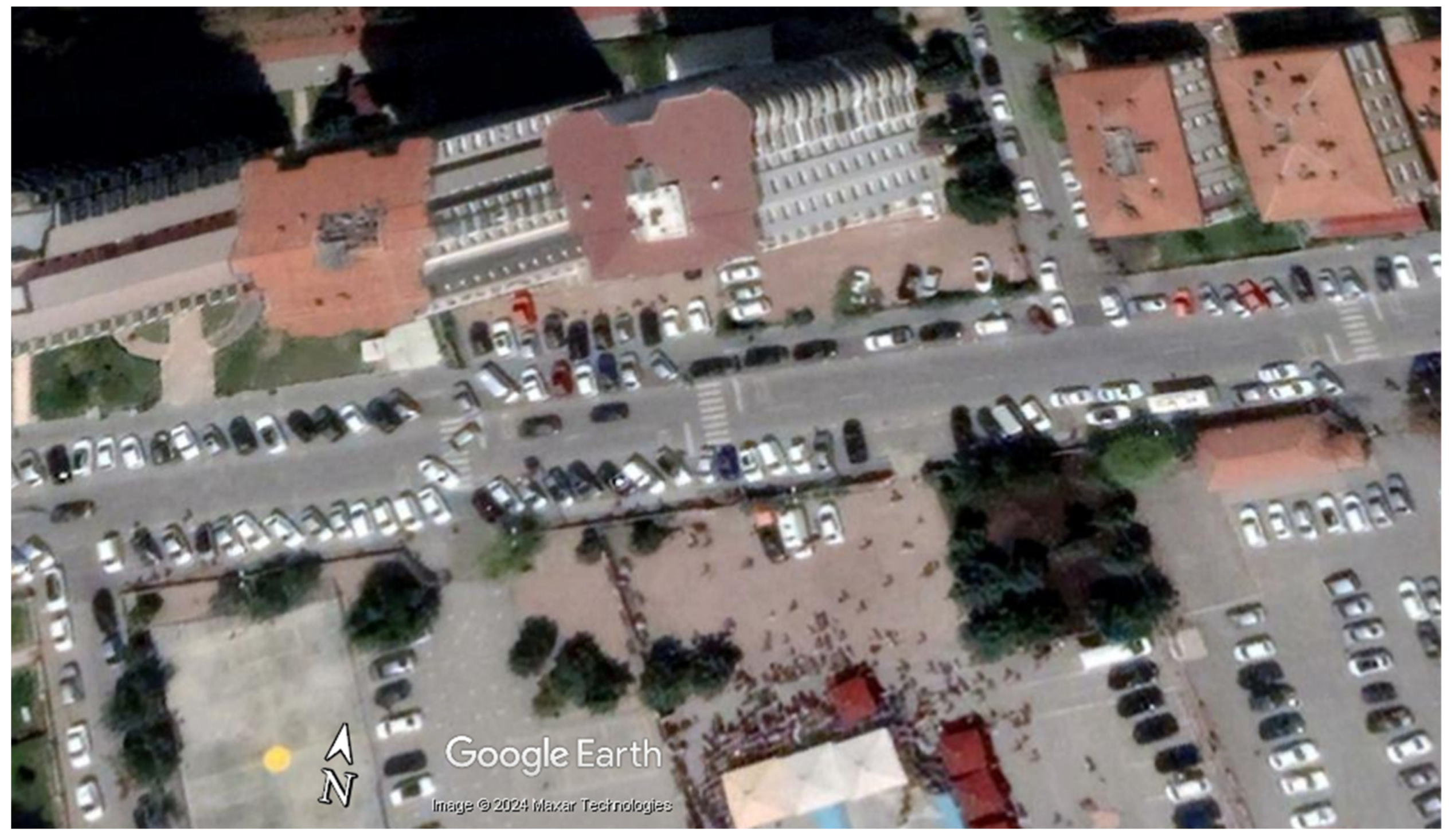
A unique feature of the study area is the absence of defined parking lines along the street, allowing vehicles to park in parallel or at various angles. In contrast to areas with marked parking spaces, where the simple distinction of “occupied” or “vacant” is sufficient, this irregularity complicates the detection of available spaces. To optimize the number of vehicles that can be accommodated, both the parking angle and position must be considered for optimization. This complexity necessitates advanced segmentation and optimization techniques to manage parking more effectively in such unique locations. Therefore, the study area was selected as an appropriate and distinctive setting to demonstrate how a framework integrating advanced segmentation and swarm optimization methods can be utilized to solve this particular problem. Figure 2 shows a satellite image captured in 2022 and obtained from Google Earth (© 2024 Maxar Technologies), that illustrates the parking challenges and high traffic density in the region.
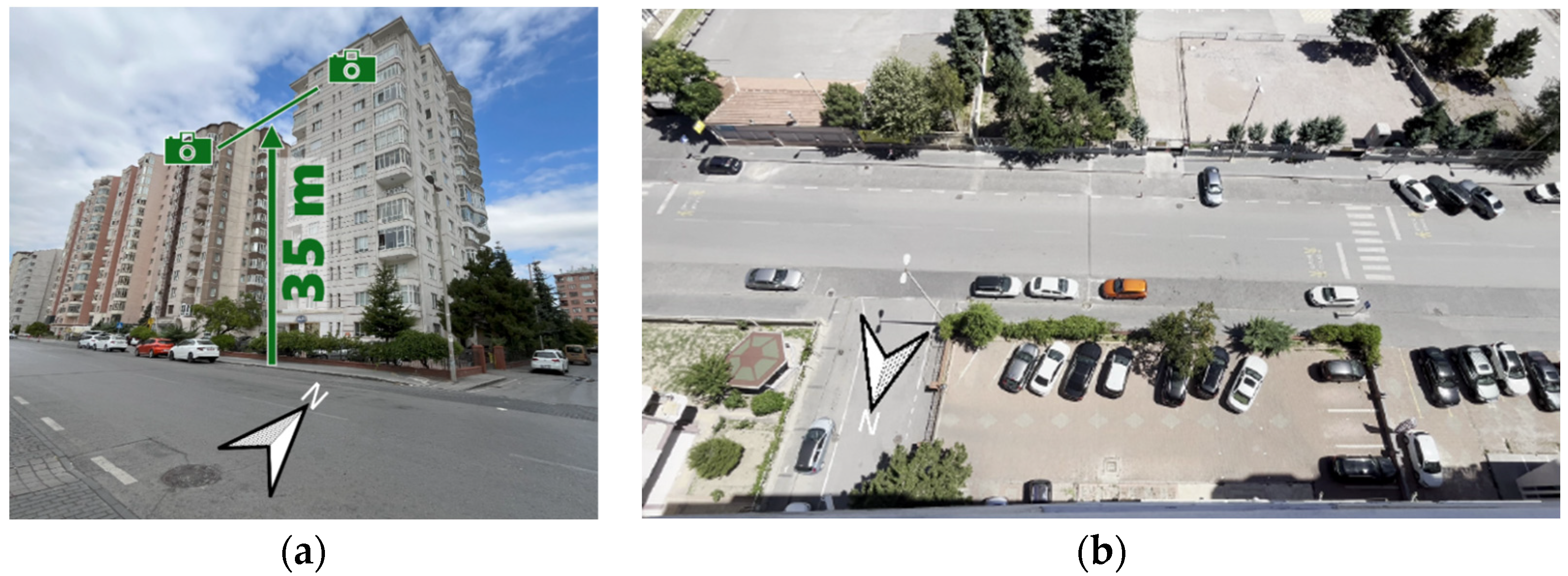
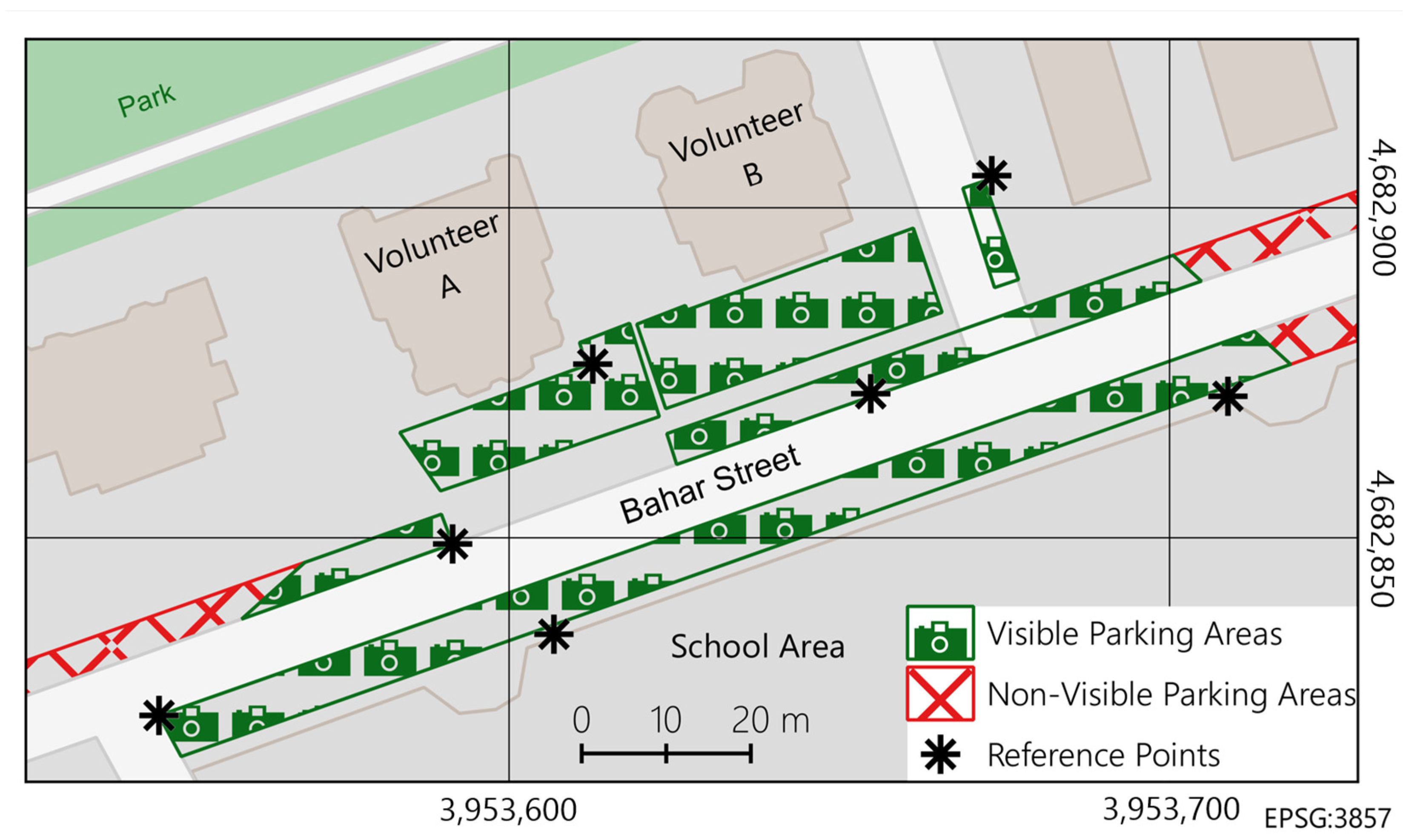
To monitor the area, two volunteers residing in adjacent buildings on the 11th floor provided continuous camera footage. These cameras were strategically positioned to capture the most congested parking spots, offering a comprehensive view that covered approximately 3200 m2, of which about 1710 m2 comprised parking spaces. The parking areas included both roadside parking spaces and private parking areas belonging to the two buildings. The cameras captured live video at a resolution of 1920 × 1080 pixels and 30 frames per second, with the feed continuously streamed to a web server for real-time processing by the YOLO algorithm. The Imou Bullet 2E cameras, equipped with a 2 MP (Mega Pixel) sensor and a fixed 2.8 mm lens providing a 102° horizontal and 54° vertical field of view, were installed at a 12-degree downward angle. Their night vision capability of up to 30 m and IP67 weatherproof rating made them suitable for outdoor use. Figure 3 illustrates the volunteers’ buildings where the cameras were installed and provides an example image captured by the cameras. Figure 4 presents the map of the study area, showing the extent of parking coverage and the reference points used for the transformations.
As mentioned in the current experiment, data were collected from two stationary cameras installed on neighbouring buildings. This approach allowed for the verification of the effectiveness and feasibility of the proposed solution under controlled conditions. The cameras, mounted at an approximate height of 35 m, provided high-resolution images (1920 × 1080 pixels), enabling precise segmentation of vehicles and analysis of available parking spaces.
The introduction of crowdsourcing enables the dynamic expansion of the system’s scope, supported by users who provide data on available parking spaces through their privately owned cameras shared on a voluntary basis. Through crowdsourcing, the system is given the ability to better adapt to changing urban conditions and extend its functional coverage, enhancing its usability in real-world applications.
In the future, we plan to integrate crowdsourced data as a key element of the system’s development. These data will originate from users reporting parking space availability through a mobile application or other means. To ensure its reliability, validation mechanisms such as comparison with data from stationary cameras and automated quality assessment algorithms will be implemented. The inclusion of crowdsourcing will enable dynamic expansion of the system’s coverage, better adaptation to changing urban conditions, and enhanced usability in real-world applications.

3.3.2. Transformation Process

To accurately transform each segmented vehicle boundary into real-world spatial polygons, a projective transformation method was employed, utilizing seven common reference points with known coordinates in both the image coordinate system and the EPSG:3857 (Web Mercator with WGS84 datum) system, as shown in Figure 4. This transformation enabled the identification of unoccupied spaces by subtracting the areas of occupied vehicles from predefined parking zones, which were stored as vector geometries in the database.
This two-dimensional projective transformation maps points from one coordinate system to another by using eight parameters, allowing for the precise calculation of new point positions based on the reference coordinates. Given the oblique angles in the camera images, this method was chosen over simpler alternatives, such as Affine or Helmert transformations, to achieve higher accuracy. For a detailed explanation of the methodology, see Ghilani [81]. The achieved root mean square error (RMSE) was 0.57 m, ensuring a high level of mapping precision.
The transformation was performed once for each camera using a single frame from the video to calculate the transformation parameters. These parameters were then applied consistently to all subsequent frames, as the camera positions remained unchanged throughout the video sequence. This approach eliminated the need for recalculating the parameters for each frame, ensuring that the vehicle coordinates could be accurately mapped to real-world coordinates for the entire video.
This transformation is essential for providing real-time parking availability to users via mobile applications. The process operates seamlessly in the background, continuously updating parking information without requiring users to understand or engage with the underlying technical details.

3.3.3. The You Only Look Once (YOLO) Algorithm for Object Segmentation in Images

In this study, a pre-trained YOLO v9e segmentation model was fine-tuned to perform precise segmentation of a single object class: cars. By leveraging this pre-trained model, training time and computational resources were minimized while enhancing segmentation accuracy for the specific class. A custom dataset comprising images prominently featuring cars was assembled.
The dataset included 1129 images with pixel-level annotations for the car class. Images were sourced from Ermak [82], ensuring diversity in backgrounds, lighting conditions, and perspectives, supplemented with custom car image registration originating from the study area.
To align the images with the model’s input requirements, images were resized to a resolution of 640 × 640 pixels and normalized.
Normalization involved scaling pixel values from the range of 0–255 to 0–1 by dividing each value by 255. Additionally, for each color channel (Red, Green, and Blue), we calculated the mean and standard deviation across the entire training dataset; each pixel value then had the corresponding channel mean subtracted and was divided by the channel’s standard deviation. This standardization ensured that each channel had a mean of zero and a standard deviation of one, facilitating model convergence during training.
Data augmentation techniques were applied to enhance model robustness and prevent overfitting. Horizontal flipping reflected images to simulate different orientations, random cropping introduced variability in object positioning, color jittering adjusted brightness and contrast to mimic different lighting conditions, and Gaussian noise was added to improve resilience to image imperfections. Each original image underwent four augmentations, with each augmentation randomly selected from the aforementioned techniques, resulting in an expanded dataset of 4516 images. The augmented dataset was split into training, validation, and test sets with a ratio of 70:15:15.
This study examined the adaptation of the YOLO v9e architecture for advanced segmentation of the “car” class. The YOLOv9-seg e-model was pre-trained on the MS COCO (Microsoft Common Objects in Context) dataset, which includes 80 object classes, including “car”. By restructuring the neural network’s final layers, it was possible to generate precise segmentation masks exclusively for cars, allowing their isolation while maintaining high prediction accuracy.
To tailor the model for exclusive vehicle detection, transfer learning was employed by freezing the weights of the backbone layers responsible for extracting general visual features (such as points, edges, and textures). This allowed the training process to focus on the final network layers, which were adjusted to the specific task of vehicle detection. The output layer was modified to reduce the number of classification neurons to a single class, “vehicle”. Binary Cross-Entropy was used as the loss function, enabling effective training in the context of binary classification: “vehicle” vs. “non-vehicle”.
To maximize accuracy and efficiency, the segmentation mask decoding module underwent extensive optimization. Dynamic learning rate adjustment was employed using the StepLR schedule, reducing the rate by a factor of 0.1 every 20 epochs. Additionally, an early stopping mechanism was implemented to prevent overfitting, halting training if no significant improvement in validation loss occurred over five consecutive epochs. Training was conducted using the PyTorch framework on an NVIDIA 3090 GPU (Graphics Processing Unit) with 24 GB of memory and finished after 87 epochs, based on the analysis of loss function values for both the training and validation datasets (Figure 5). No signs of overfitting were observed, indicating an effective balance between model precision and generalization. The achieved accuracy was 0.942, with the loss function stabilizing around 0.17, reflecting high-quality segmentation and a robust training process.
By fine-tuning a pre-trained YOLO v9e model with a custom dataset of car images, high-precision segmentation of vehicles was achieved. The model was subsequently applied to detect car polygons in camera images transformed into the EPSG:3857 coordinate system. This alignment with the database of organized city parking space polygons facilitated the implementation of the ABC algorithm to detect potential free parking spots.

3.3.4. The Artificial Bee Colony (ABC) Algorithm for Parking Space Optimization

This study applies the ABC optimization algorithm to optimize the placement of parking spaces in unoccupied areas, based on predefined dimensions. The algorithm aims to maximize the number of vehicles accommodated by identifying the most efficient positions and orientations for parking spaces. To enhance efficiency, ABC optimization is applied separately to each parking zone, rather than the entire area. This approach allows for real-time data updates and integration with a database, ensuring responsive and accurate suggestions for available parking.
The optimization model is built upon three fundamental components: variables, constraints, and the cost function (or objective function). The variables represent the predefined parking space slots that are iteratively optimized to fit the maximum number of vehicles within the handled area. For each slot, random x i and y i coordinates and a rotation angle β i are assigned within the boundaries of the parking area. The algorithm then seeks the optimal configuration of these variables ( x i , y i , and β i for each slot i ) across all N parking spaces, effectively forming a solution space of N × 3 variables.
The constraints, as the second key component, ensure the feasibility of the solution by imposing the following conditions:
  • Parking slots must remain within the designated parking area.
  • Slots must not overlap with existing occupied spaces.
  • Newly allocated slots must not overlap with one another.
These constraints are enforced using geometric operations, such as inside-outside checks and intersection area calculations, leveraging vector geometry during the optimization process.
The cost function is a critical component for evaluating the quality of a given solution in the optimization process. In this study, the optimization model minimizes a cost function specifically designed to evaluate vehicle placement. Each vehicle randomly positioned by the algorithm incurs penalties based on its location: 5000 points if placed outside the designated area, penalties proportional to overlap with occupied areas, and additional penalties for overlapping with other newly placed vehicles. The objective is to minimize this cost function iteratively, achieving an optimal configuration where the cost is zero. The choice of 5000 as the penalty for vehicles placed outside the parking area reflects the need to strongly discourage such placements, as external locations should be entirely avoided by the algorithm. A smaller penalty of 300 is applied for overlaps between occupied and newly placed vehicles, ensuring that the algorithm prioritizes minimizing overlap within the parking area without incentivizing external placements. While these values are arbitrarily chosen, they can be adjusted as needed to achieve the same strategy, as long as the balance between penalties effectively guides the optimization process. Within 20 s, the algorithm successfully identified the optimal parking locations, which were then mapped to real-world coordinates.
Let C represent the total cost for a given solution. The cost function C can be expressed as:
C = i = 1 N   P out   I out , i + i = 1 N   P occupied     OP   occupied , i + i = 1 N   j = 1 i 1   P new     OP new , i j
where:
  • N is number of vehicles.
  • P out   = 5000 is the penalty for a vehicle placed outside the designated parking area.
  • I o u t , i is an indicator function that equals 1 if the i -th vehicle is outside the parking area, and 0 otherwise.
  • P occupied   = 300 is the penalty per percentage of overlap with an already occupied space.
  • OP   occupied , i is the percentage overlap of the i -th vehicle with an occupied area.
  • P new   = 300 is the penalty per percentage of overlap with another new vehicle.
  • OP   new , i j is the percentage overlap between the i -th and j -th vehicles.
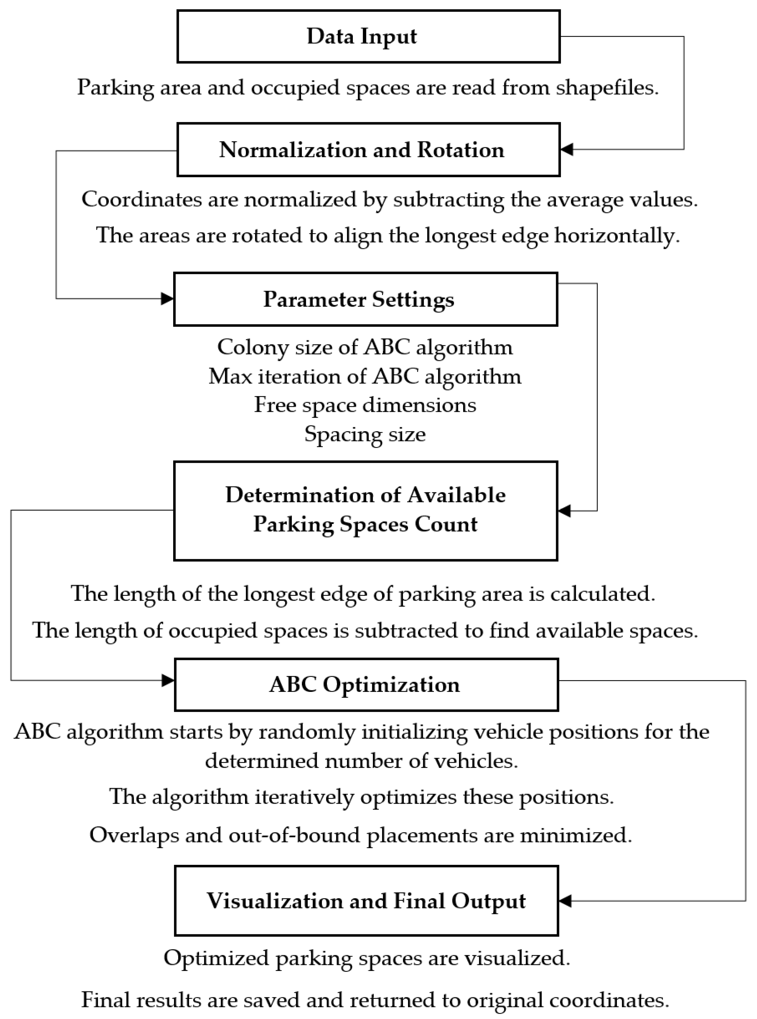
As shown in Figure 6, the ABC optimization process for this study is as follows:
The process of finding the optimal parking configuration begins with data input and pre-processing. Initially, information regarding the parking area and occupied spaces is imported in shapefile format, allowing for the extraction and structuring of the geometric shapes for analysis. Following the data preparation, the coordinates of the parking area and the occupied spaces are normalized by subtracting the average values, resulting in more manageable numbers. To streamline the search process, the longest edge of the parking area is aligned with the x-axis, significantly reducing the search space for the ABC algorithm and improving the efficiency of the optimization. Next, the dimensions of the parking area, along with the desired spacing, are specified. The total length of the parking area along the x-axis is calculated, and the length of the occupied regions is subtracted to determine the available space for parking. The optimization then proceeds with the application of the ABC algorithm, which simulates the foraging behavior of bee colonies. The algorithm generates random configurations of parking spaces and iteratively searches for the optimal positions along the x-axis. A fitness function is used to assess each configuration, accounting for penalties related to overlaps and boundary violations. The search continues until the algorithm reaches the minimum cost or a specified number of iterations.
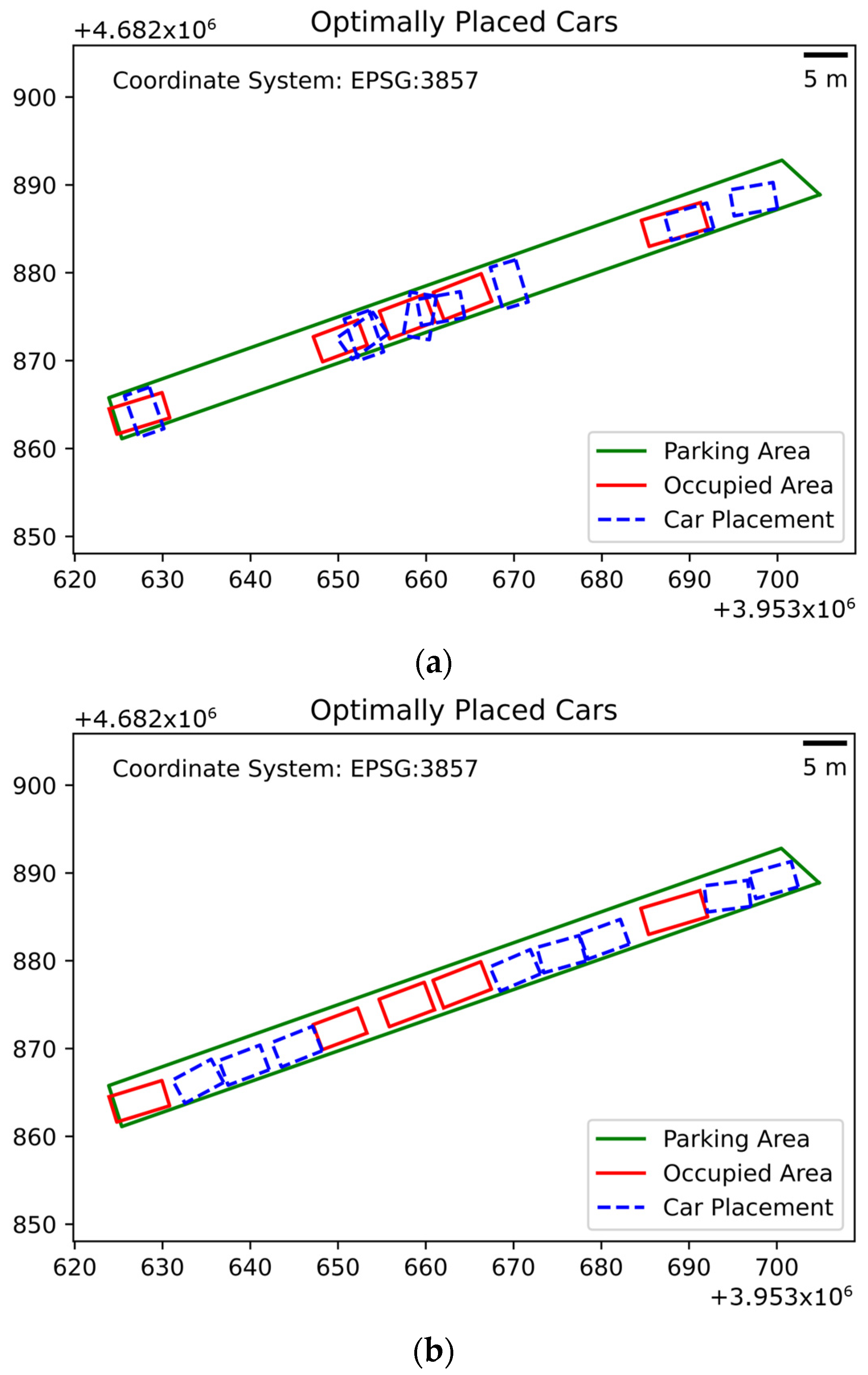
Finally, after determining the optimal parking arrangement, the coordinates are reverted to their original scale. The optimized configuration is then visualized, and the results are saved in a shapefile format, enabling the layout to be displayed on a map for users. Figure 7 presents the results from the ABC optimization process, illustrating the placement of vehicles after different iteration counts.
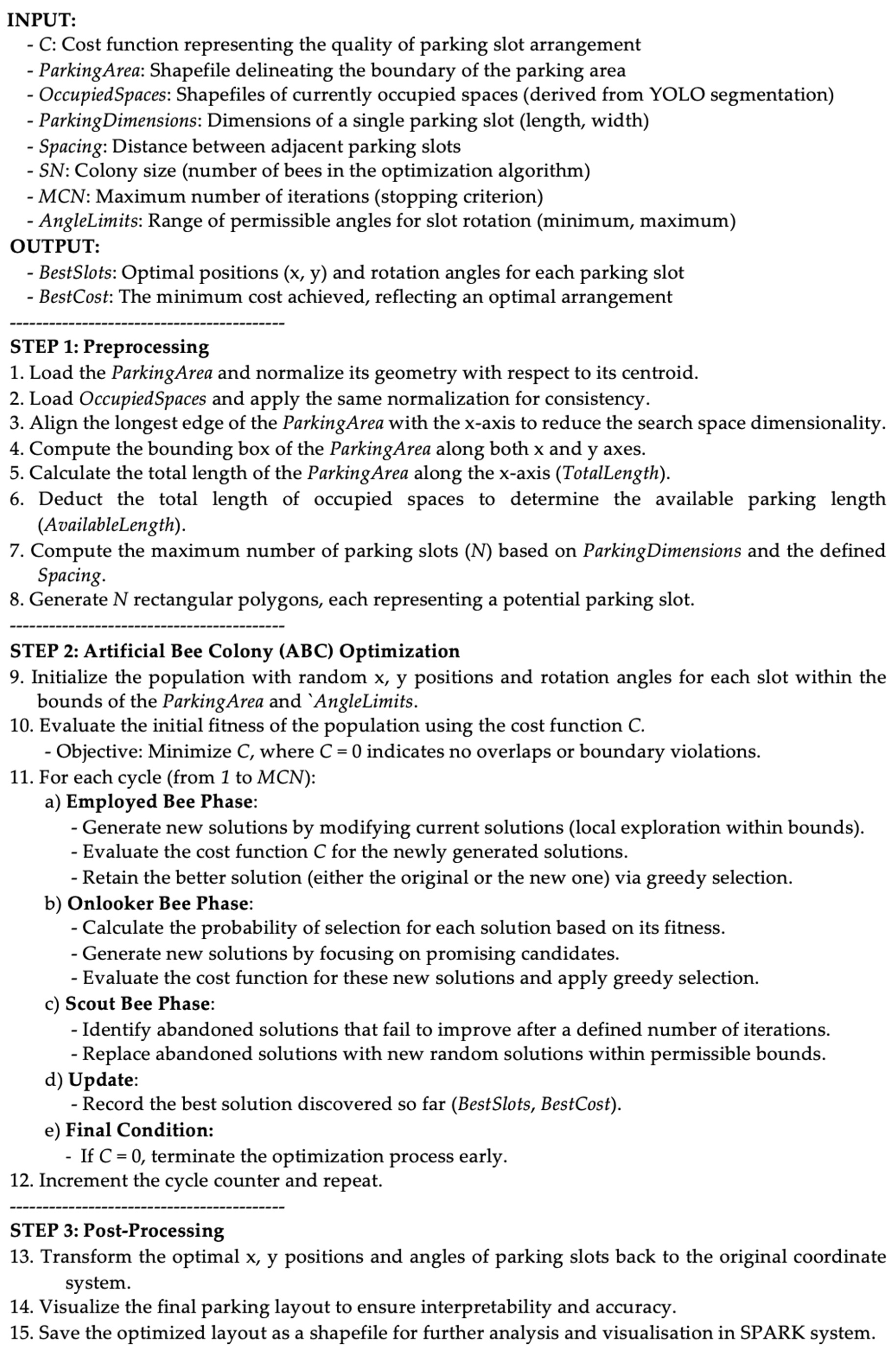
Figure 8 presents the pseudo-code of the proposed optimization approach. The variation of the cost function value over iterations and elapsed time is presented in Figure 9, which also illustrates the optimization performance for a sample application.

3.3.5. Application Architecture and Data Workflow

For practical verification of the feasibility study, the system consists of functional and structural components, as shown in Figure 10:
  • Cameras: Image capture.
  • Server (SFTP (Secure File Transfer Protocol), Watchdog, Redis (Remote Dictionary Server), YOLO, ABC, PostgreSQL, Nginx, and Django):
    • SFTP (server): Transmission of images from the cameras.
    • Watchdog (library): Monitoring the appearance of new image files.
    • Redis Queue (server): Processing queue.
    • YOLO Segmentation (module): Car image segmentation.
    • ABC Module: Optimization of parking spaces.
    • PostgreSQL (database): Storage of results.
    • Nginx (server): HTTPS handling, redirection to Django.
    • Django (application server): Data processing.
  • User (Browser, GPS (Global Positioning System), and Google Maps):
    • Browser: System communication and visualization.
    • GPS (module): Location data.
  • Google Maps (service): Map visualization.
Stationary cameras are installed on building facades at elevated heights, allowing for coverage of the largest possible parking area. Each camera is stabilized to ensure that its spatial orientation relative to the parking spaces remains constant, enabling continuous monitoring without frequent recalibration, even under external factors such as vibrations or weather conditions.
Projective transformation techniques are employed to ensure the geometric accuracy of vehicle boundary predictions in the images. These transformations accurately convert the camera’s image into a form suitable for detecting available parking spaces. The fixed orientation of the cameras, combined with the precision of the projective transformation, enables high accuracy in vehicle position analysis, generally within a sub-meter range depending on camera parameters and the monitored area.
The collected camera images are analyzed in real-time on the local server, without requiring user intervention for manual uploads, significantly accelerating and automating the detection of available parking spaces. All image data are processed locally on the server, minimizing delays and maximizing system performance.
The system uses a specifically trained YOLOv9 module for detecting vehicles as a single class. As mentioned earlier, this model was developed using transfer learning from the publicly available YOLOv9e Seg model, focusing exclusively on vehicle detection. This approach optimized the system’s performance and increased its accuracy under the specific conditions encountered in parking areas.
The ABC algorithm is used to optimize the selection of the best parking spot based on multiple criteria, including minimizing distance, maximizing availability, and reducing the time needed to park. The data, representing parking areas as polygons and detected vehicles within those polygons, are passed to the ABC algorithm. Each polygon corresponds to a potential parking spot, and the ABC algorithm efficiently allocates vehicles to available spaces. Currently, the time required to optimize vehicle placement is a system bottleneck, requiring further optimization to enhance performance. The authors are actively investigating strategies to improve the system’s speed and efficiency.
The system operates on a server with Nginx as the HTTP server, handling HTTPS (Hypertext Transfer Protocol Secure) traffic through an SSL (Secure Sockets Layer) certificate provided by Let’s Encrypt. Nginx functions as the front-end server, directing traffic to the Django-based application backend and ensuring secure, encrypted communication. The server also runs an SFTP (Secure File Transfer Protocol) server on Alpine Linux, with each camera having a dedicated directory for storing images. The presence of a new image triggers subsequent processing steps. The system monitors changes in the directories using the Watchdog utility, which detects new files and triggers the image analysis process, utilizing geometric data (projective transformation parameters) specific to each camera. This automation ensures immediate data processing without manual intervention. Each image processing task is added to a task queue managed by Redis, which handles asynchronous processing of large numbers of tasks, ensuring efficient load management. Detection results (e.g., object boundaries) are then mapped to spatial coordinates using projective transformation parameters specific to each camera, allowing precise mapping of detected objects to the overall system’s spatial map.
The system’s client component, presented in Figure 11, is a web application accessible through modern web browsers, compatible with nearly all contemporary hardware platforms, including desktop (Windows, macOS, and Linux) and mobile devices (smartphones and tablets running iOS or Android). The application is fully responsive, dynamically adjusting its interface to the device’s screen size. It displays real-time data on available parking spaces and periodically checks for changes in the monitored area. A predefined interval is set for regular server requests, which verify whether new images have been processed and if any changes in parking space status have been registered. When changes are detected, the application automatically retrieves updated data from the server, providing real-time updates without requiring manual page refreshes. The client interface integrates Google Maps as the base layer, allowing users to easily navigate and visualize available parking spaces, with automatic updates for any changes.
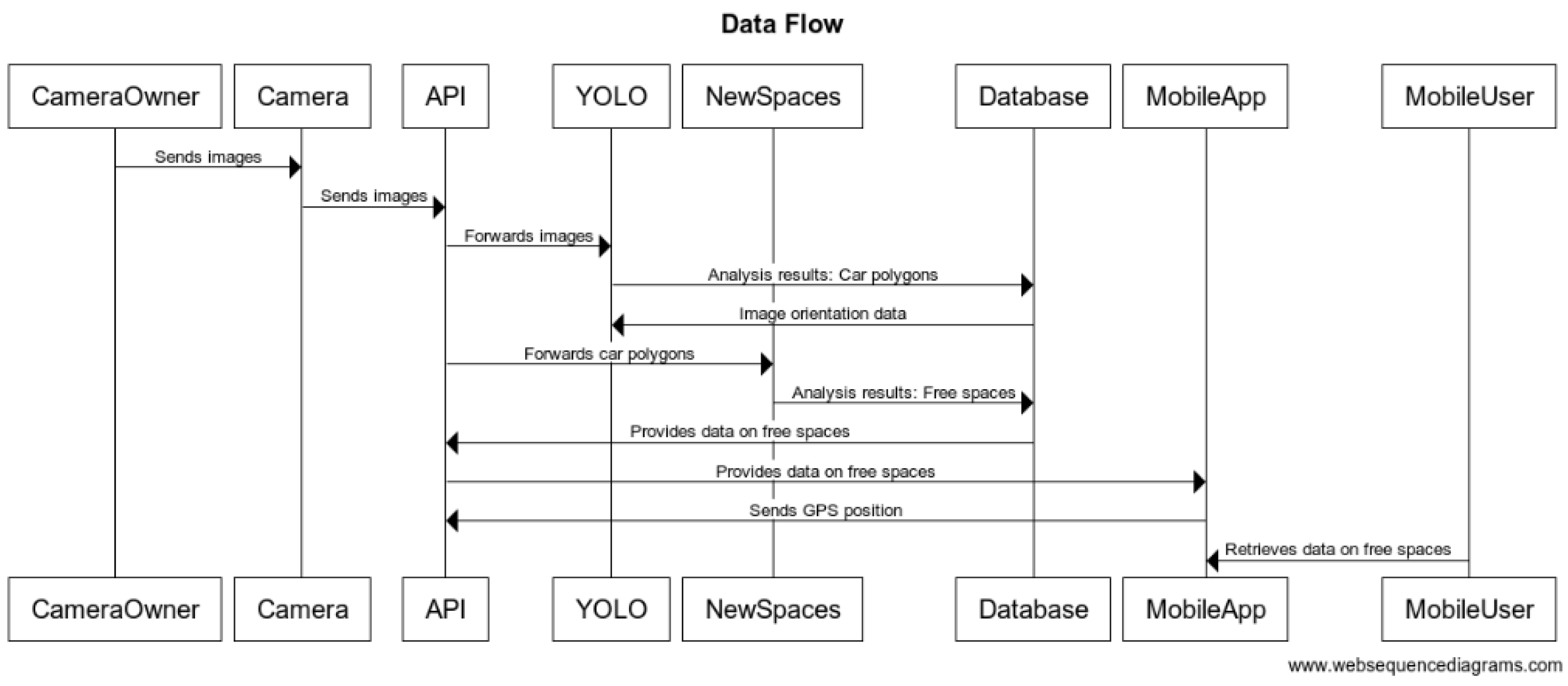
The system is designed to fully respect privacy regulations. Image capture is strictly limited to public areas, and the elevated positioning of the cameras ensures that private details, such as vehicle interiors, faces, or license plates, are not recorded, effectively preventing the identification of individuals or vehicles. Once the images have been analyzed by the YOLO algorithm, the data are immediately deleted from the server, eliminating the need for storage and minimizing privacy risks and operational costs. By combining these measures, the system ensures a high level of privacy protection while optimizing resource efficiency. The data flow diagram summarizing the business logic of the application is presented below in Figure 12.

4. Results

The goal of this study is to evaluate the performance of the SPARK system in detecting both vehicles and available parking spaces within an urban environment. The system integrates advanced image detection algorithms and optimization techniques to provide a reliable solution to parking management in increasingly congested areas. This section presents the results obtained from a detailed analysis of the devices used, followed by a discussion on the implications of these findings. The key performance indicators assessed include precision, recall, and accuracy, which reflect the system’s effectiveness in identifying vehicles and parking spots. A comparative analysis between the YOLOv9e Seg car detection model and the SPARK system’s parking detection capability is also provided.
This analysis was conducted on 120 pairs of images (from two cameras) selected every two hours. Below is a summary of the key metrics for YOLOv9e Seg car detection (with an optimal threshold of 0.72) and SPARK parking detection.
The effectiveness of SPARK was evaluated using three metrics:
Precision: This measures how well the model avoids false positives. The higher the precision, the fewer errors the model makes in predicting positive cases. The formula considers true positives (TP) and false positives (FP).
P r e c i s i o n = T P T P + F P
Recall: Also referred to as sensitivity, it assesses how well the model identifies all positive cases. A higher recall means the model misses fewer true positives. The formula takes into account true positives (TP) and false negatives (FN).
Recall = T P T P + F N
Accuracy: This is a general measure of how well the model classifies both positive and negative cases. It considers true positives (TP), true negatives (TN), false positives (FP), and false negatives (FN), indicating the overall correctness of the model’s predictions.
Accuracy = T P + T N T P + T N + F P + F N
where:
  • TP (True Positives): The number of instances where the model correctly predicted a positive outcome.
  • FP (False Positives): The number of instances where the model predicted a positive outcome, but the actual reality was negative.
  • FN (False Negatives): The number of instances where the model predicted a negative outcome, but the actual reality was positive.
  • TN (True Negatives): The number of cases where both the model and reality correctly identified a negative outcome.
Table 1 presents a summary of the average values of the parameters calculated for 120 pairs of test images.
Regarding Table 1, the obtained results were interpreted as follows. Vehicle detection (YOLOv9e Seg) within the SPARK system for the test space in Kayseri city, with a threshold set at 0.72, achieved an average precision of 0.928, indicating excellent avoidance of false positives, with a low standard deviation (0.016). The model also performed well in detecting positive cases (average recall of 0.884), though some variability was observed (standard deviation of 0.064), suggesting occasional vehicle omissions in more complex scenarios. The overall accuracy of the model was 0.825. In terms of parking space detection, the system achieved a precision of 0.891, demonstrating that in most instances, available spaces were correctly classified. The recall (0.863) shows that the system detected the majority of available spaces, though some were missed in isolated cases (standard deviation of 0.122). The overall accuracy of the system averaged 0.833, with variability primarily arising in scenarios of low parking space density, which introduced greater uncertainty in feature extraction and classification processes.
The obtained results, encompassing effective detection of vehicles and parking spaces while maintaining high accuracy and near-real-time processing, are particularly significant in the context of rapidly advancing urbanization and the growing need for efficient management of municipal resources. In relation to solutions based on artificial intelligence and machine learning [83,84], the proposed approach presents an attractive alternative to traditional systems founded on fixed markings and constrained vehicle orientation rules [85,86].
This flexibility is achieved through an image segmentation methodology employing cameras positioned at elevated vantage points (e.g., atop high-rise buildings), thereby affording a comprehensive field of view and expeditious detection of both occupied and unoccupied parking areas. The YOLOv9 semantic segmentation framework facilitates the precise identification of available and occupied regions. Subsequently, the ABC optimization algorithm ensures the maximal utilization of these polygonal spaces by optimally fitting rectangular representations of vehicles. A key advantage of this approach lies in its ability to position these rectangles at arbitrary angles, thus enhancing adaptability to heterogeneous urban environments where formalized parking guidelines are limited or altogether absent.
A salient consideration is the computational complexity of the proposed solution. YOLOv9-based segmentation can be optimized for near-real-time performance. On the employed hardware configuration (featuring an NVIDIA RTX 3090 GPU with 24 GB of memory), the mean segmentation time per image was approximately 0.62 s. Although ABC-based optimization is computationally more demanding, its performance can be significantly improved through heuristic strategies, search space reduction methods, and parallelized implementations [87]. In the tested non-optimized Python environment (without parallel computing), the processing of polygons obtained from the segmentation phase for a single image required an average of 0.44 s. Overall, managing a single image within the proposed framework required less than 1.3 s. Comparable challenges relating to scalability and computational efficiency have been documented in other research, including the modeling and forecasting of transport flows and the utilization of extensive urban datasets [83,84], underscoring the universality of these issues.
The presented system, currently in its developmental stage and early implementation phase, has achieved accuracy comparable to other global solutions while maintaining near-real-time performance on mid-range home PC hardware. This level of accuracy offers a promising outlook for the system’s development, providing a solid foundation for creating a cost-effective and efficient solution that can be successfully replicated to manage parking spaces within the communities of large urban agglomerations.

5. Discussion and Conclusions

The results indicate a high level of performance from both the vehicle detection and parking detection subsystems. However, while vehicle detection achieved consistent performance across metrics, parking space detection exhibited more variability. This variability is likely due to the inherent complexity of parking spaces, which often require more nuanced interpretation compared to the clearer and more distinct vehicle outlines. A significant challenge encountered in parking detection involves fitting predefined polygons to match real-world parking spaces using the ABC algorithm. This task becomes more complicated when parking spaces are irregularly shaped or constrained, leading to errors in correctly identifying available spaces. Additionally, relying on fixed camera positions, currently lacking verification of the invariability of this parameter, and predefined parking polygons may fail to account for dynamic changes in parking layouts or unexpected obstructions, limiting the scalability of the system.
Given the growing demand for efficient parking management in urban areas, the technical innovations provided by the SPARK system represent a notable contribution to addressing the parking availability problem. The integration of advanced deep learning algorithms, such as the YOLOv9e Seg, along with swarm optimization techniques, allows the system to operate effectively under various conditions. In the SPARK system, the YOLOv9e Seg algorithm identifies vehicles, and the ABC algorithm uses this information to determine optimal vacant parking spaces. This dual approach, combining image recognition with optimization techniques, strengthens the system’s ability to provide accurate, real-time information on parking availability. Moreover, the use of crowdsourced data can enhance the system’s ability to adapt and improve over time by generating larger training datasets, leading to continuous improvements in detection and optimization. However, the system also faces challenges that need to be addressed. For instance, maintaining data quality and ensuring user privacy, especially with the use of crowdsourced data, are significant concerns. Crowdsourced data introduce variabilities in quality, requiring robust validation mechanisms and reputation-based scoring systems to ensure reliability. Furthermore, the system’s performance can be affected by environmental factors, such as weather conditions, varying lighting conditions, or complex parking scenarios, which could compromise the accuracy of parking space detection. Tests conducted under different conditions—day and night—indicated that street lighting in the test area helped maintain consistent segmentation performance for vehicles, although parking space detection remained susceptible to environmental influences. One key observation from the results is the discrepancy in recall and precision between the YOLOv9e Seg model and the SPARK system. The vehicle detection subsystem displays stable performance across all metrics, whereas parking detection shows higher variability. This could be attributed to the more subtle visual indicators required for identifying available spaces. Scenarios with lower parking space density, in particular, tend to generate more inaccuracies in detection, likely due to overlapping objects or unconventional parking arrangements. Moreover, the ABC algorithm’s reliance on predefined penalty parameters limits its ability to adapt to diverse parking scenarios, suggesting the need for dynamic real-time parameter tuning or the preparation of multiple models, which could be alternately activated within the system depending on specific conditions affecting the system’s performance. These cases challenge the robustness of both the YOLOv9e Seg model and the ABC algorithm, indicating the need for more adaptive techniques that can account for occlusions or partial detections in complex environments. In such challenging cases, alternative approaches—such as fusing data from various sensor types—may be necessary to maintain high levels of accuracy. For example, in more advanced versions of the system, combining image data with ultrasonic or infrared sensors could enhance the system’s robustness under varying environmental conditions. Despite these challenges, the SPARK system has significant potential for improving urban mobility by reducing traffic congestion, lowering emissions, and enhancing user convenience. Its potential integration with other urban infrastructure systems provides opportunities to develop more comprehensive smart city solutions. Future research should explore ways to further enhance detection algorithms, increase system integration with navigation frameworks, and expand functionalities, such as enabling parking reservations. Moreover, the ongoing development of technologies such as the IoT and AI holds great promise for advancing parking management systems such as SPARK, making them more reliable, scalable, and capable of adapting to a wider range of real-world conditions.
In conclusion, the SPARK system has demonstrated strong potential in solving parking management issues in urban areas by using advanced technologies such as the YOLOv9e Seg model for vehicle detection and the ABC algorithm for optimizing parking space allocation. Although some variability was noted in parking space detection, the system overall provides an effective and scalable solution for managing parking in congested cities.
Moving forward, further improvements should focus on making the system more resilient to environmental factors and ensuring high data quality and privacy, especially when using crowdsourced data. These improvements may include the mentioned integration of adaptive learning models for dynamic tuning of detection algorithms, as well as the incorporation of additional external sensors to enhance the system’s functionality. These enhancements will be important to increase the system’s accuracy and reliability. Looking ahead, the SPARK system could become a key component of smart city infrastructures. By integrating emerging technologies such as the IoT and AI, the system can evolve into a broader urban mobility solution that not only improves parking management but also contributes to making cities smarter and more sustainable.
Expanding testing to diverse locations and varying environmental conditions will also be a priority, enabling an evaluation of the system’s scalability and reliability in broader contexts. Furthermore, the integration of publicly available datasets is planned, which will not only facilitate cross-study comparisons but also contribute to a more thorough validation of the proposed approach.

Author Contributions

Conceptualization, A.J., M.H. and M.R.-B.; methodology, A.J., M.H. and M.R.-B.; software, A.J., M.H. and M.R.-B.; validation, A.J., M.H. and M.R.-B.; formal analysis, A.J., M.H. and M.R.-B.; investigation, A.J., M.H. and M.R.-B.; resources, A.J., M.H. and M.R.-B.; data curation, A.J., M.H. and M.R.-B.; writing—original draft preparation, A.J., M.H. and M.R.-B.; writing—review and editing, A.J., M.H. and M.R.-B.; visualization, A.J., M.H. and M.R.-B.; supervision, A.J., M.H. and M.R.-B.; project administration, A.J., M.H. and M.R.-B.; funding acquisition, A.J., M.H. and M.R.-B. All authors have read and agreed to the published version of the manuscript.

Funding

This research received no external funding.

Data Availability Statement

The data presented in this study are available in the Orion Cars dataset at https://universe.roboflow.com/denis-ermak/orion_cars (accessed on 10 December 2024). These data were derived from the following resource available in the public domain: RoboFlow Universe (https://universe.roboflow.com (accessed on 10 December 2024)). The dataset was created by Denis Ermak and is used under the terms of the Creative Commons Attribution 4.0 International License (CC BY 4.0).

Conflicts of Interest

The authors declare no conflicts of interest.

References

  1. Gary, M.R.; Johnson, D.S. Computers and Intractability: A Guide to the Theory of NP-Completeness; W. H. Freeman: New York, NY, USA, 1979. [Google Scholar]
  2. Shoup, D. The High Cost of Free Parking. J. Plan. Educ. Res. 1997, 17, 3–20. [Google Scholar] [CrossRef]
  3. Krishnamurthi, R.; Kumar, A.; Gopinathan, D.; Nayyar, A.; Qureshi, B. An Overview of IOT Sensor Data Processing, Fusion, and Analysis Techniques. Sensors 2020, 20, 6076. [Google Scholar] [CrossRef]
  4. Corrado, A.; Barba, S.; Carozzo, I.; Nardi, S. Smart Passenger Center: Real-Time Optimization of Urban Public Transport. In The International FLAIRS Conference Proceedings; Florida Artificial Intelligence Research Society: Orlando, FL, USA, 2023. [Google Scholar]
  5. Kumar, G.; Basri, S.; Imam, A.A.; Khowaja, S.A.; Capretz, L.F.; Balogun, A.O. Data Harmonization for Heterogeneous Datasets: A Systematic Literature Review. Appl. Sci. 2021, 11, 8275. [Google Scholar] [CrossRef]
  6. Rodriguez, A.; Gutierrez, A.; Rivera, L.; Ramirez, L. RWA: Comparison of Genetic Algorithms and Simulated Annealing in Dynamic Traffic. In Advanced Computer and Communication Engineering Technology, Proceedings of the 1st International Conference on Communication and Computer Engineering, Rajshahi, Bangladesh, 26–27 November 2015; Springer: Cham, Switzerland, 2015; pp. 3–14. [Google Scholar]
  7. Awaisi, K.S.; Abbas, A.; Khattak, H.A.; Ahmad, A.; Ali, M.; Khalid, A. Deep Reinforcement Learning Approach Towards A Smart Parking Architecture. Clust. Comput. 2023, 26, 255–266. [Google Scholar] [CrossRef]
  8. Shoeibi, N.; Shoeibi, N. Future of smart parking: Automated valet parking using deep Q-learning. In Distributed Computing and Artificial Intelligence, 16th International Conference, Special Sessions; Springer: Cham, Switzerland, 2020; pp. 177–182. [Google Scholar]
  9. Zedadra, O.; Guerrieri, A.; Jouandeau, N.; Spezzano, G.; Seridi, H.; Fortino, G. Swarm Intelligence and IoT-Based Smart Cities: A Review. In The Internet of Things for Smart Urban Ecosystems; Cicirelli, F., Guerrieri, A., Mastroianni, C., Spezzano, G., Vinci, A., Eds.; Springer International Publishing: Cham, Switzerland, 2019; pp. 177–200. [Google Scholar]
  10. Mikusova, M.; Abdunazarov, J.; Zukowska, J. Modelling of The Movement of Designed Vehicles on Parking Space for Designing Parking. In Development of Transport by Telematics, Proceedings of the 19th International Conference on Transport System Telematics, TST 2019, Jaworze, Poland, 27 February–2 March 2019; Springer: Cham, Switzerland, 2019; pp. 188–201. [Google Scholar]
  11. Mihaljčić, G.; Mihaljčić, B.; Marić, B. Analysis of the current situation and a proposal to solve the parking problem in the center of the city of Banja Luka by introducing new street parking spaces. J. Road Traffic Eng. 2024, 70, 61–66. [Google Scholar] [CrossRef]
  12. Allam, Z.; Nieuwenhuijsen, M.; Allam, Z. Paris’s parking policy for healthier cities. Lancet Planet. Health 2024, 8, e343–e344. [Google Scholar] [CrossRef] [PubMed]
  13. Miao, H.; Guan, H.; Han, Y.; Wang, H. Research of park and ride parking spaces tiered pricing methodology based on subway ride distance. Appl. Sci. 2024, 14, 3550. [Google Scholar] [CrossRef]
  14. Shrivastava, S. Smart Cities, Smarter Parking: Developing and Implementing Vehicle Parking Management System. Int. J. Multidiscip. Res. 2024, 6, 1–10. [Google Scholar] [CrossRef]
  15. Yang, S.; Huang, L. Research on planning and management of urban parking lot—Taking Hangzhou as an example. Curr. Urban Stud. 2017, 5, 379–386. [Google Scholar] [CrossRef]
  16. Fateha, M.R.; Mukta, M.S.H.; Hossain, M.A.; Al Islam, M.; Islam, S. SlotFinder: A Spatio-Temporal Based Car Parking System. In Proceedings of the 25th International Conference on Computer and Information Technology (ICCIT), Cox’s Bazar, Bangladesh, 17–19 December 2022; pp. 114–119. [Google Scholar]
  17. Lucchese, C.; Callegher, G.; Modenese, M.; Dassiè, S. A Comparison of Spatio-Temporal Prediction Methods: A Parking Availability Case Study. In Proceedings of the 37th ACM/SIGAPP Symposium on Applied Computing, Virtual, 25–29 April 2022; pp. 1013–1020. [Google Scholar]
  18. Errousso, H.; Filali, Y.; Aghbalou, N.; Alaoui, E.A.A.; Benhadou, S. Spatio-Temporal Clustering For Optimal Real-Time Parking Availability Estimation. In Proceedings of the International Conference on Smart City Applications, Paris, France, 4–6 October 2023; pp. 199–214. [Google Scholar]
  19. Sairam, B.; Agrawal, A.; Krishna, G.; Sahu, S.P. Automated Vehicle Parking Slot Detection System Using Deep Learning. In Proceedings of the Fourth International Conference on Computing Methodologies and Communication (ICCMC), Erode, India, 11–13 March 2020; pp. 750–755. [Google Scholar]
  20. Biswal, M. Predicting free parking slot availability using hybrid machine learning model. Int. J. Adv. Res. Interdiscip. Sci. Endeav. 2024, 1, 15–21. [Google Scholar]
  21. Carrese, S.; d’Andreagiovanni, F.; Giacchetti, T.; Nardin, A.; Zamberlan, L. An Optimization Model and Genetic-Based Matheuristic for Parking Slot Rent Optimization to Carsharing. Res. Transp. Econ. 2021, 85, 100962. [Google Scholar] [CrossRef]
  22. Bai, Y.; Qian, Q. Optimal Placement of Parking of Electric Vehicles in Smart Grids, Considering their Active Capacity. Electr. Power Syst. Res. 2023, 220, 109238. [Google Scholar] [CrossRef]
  23. Carrese, S.; d’Andreagiovanni, F.; Giacchetti, T.; Nardin, A.; Zamberlan, L. An Optimization Model for Renting Public Parking Slots to Carsharing Services. Transp. Res. Procedia 2020, 45, 499–506. [Google Scholar] [CrossRef]
  24. Sayarshad, H. Designing Intelligent Public Parking Locations for Autonomous Vehicles. Expert Syst. Appl. 2023, 222, 119810. [Google Scholar] [CrossRef]
  25. Singh, R.; Dutta, C.; Singhal, N.; Choudhury, T. An Improved Vehicle Parking Mechanism to Reduce Parking Space Searching Time Using Firefly Algorithm and Feed Forward Back Propagation Method. Procedia Comput. Sci. 2020, 167, 952–961. [Google Scholar] [CrossRef]
  26. Carrese, S.; d’Andreagiovanni, F.; Giacchetti, T.; Nardin, A.; Zamberlan, L. A Beautiful Fleet: Optimal Repositioning in e-Scooter Sharing Systems for Urban Decorum. Transp. Res. Procedia 2021, 52, 581–588. [Google Scholar] [CrossRef]
  27. Lei, C.; Zhang, Q.; Ouyang, Y. Planning of Parking Enforcement Patrol Considering Drivers’ Parking Payment Behavior. Transp. Res. Part B Methodol. 2017, 106, 375–392. [Google Scholar] [CrossRef]
  28. Assemi, B.; Paz, A.; Baker, D. On-Street Parking Occupancy Inference Based on Payment Transactions. IEEE Trans. Intell. Transp. Syst. 2021, 23, 10680–10691. [Google Scholar] [CrossRef]
  29. Chu, J.C.; Lin, H.-C.; Liao, F.-Y.; Yu, Y.-H. Dynamic Repositioning Problem of Dockless Electric Scooter Sharing Systems. Transp. Lett. 2023, 15, 1066–1082. [Google Scholar] [CrossRef]
  30. Kittur, A.; Chi, E.H.; Suh, B. Crowdsourcing User Studies with Mechanical Turk. In Proceedings of the SIGCHI Conference on Human Factors in Computing Systems, Florence, Italy, 5–10 April 2008; pp. 453–456. [Google Scholar]
  31. Ipeirotis, P.G.; Provost, F.; Wang, J. Quality Management on Amazon Mechanical Turk. In Proceedings of the ACM SIGKDD Workshop on Human Computation, Washington, DC, USA, 25 July 2010; pp. 64–67. [Google Scholar]
  32. Rafiei, D.; Javanmard, A. Enhancing data quality in crowdsourcing systems with trust and reputation management. J. Comput. Soc. Sci. 2020, 3, 43–56. [Google Scholar]
  33. Voigt, P.; Von dem Bussche, A. The EU General Data Protection Regulation (GDPR); Springer International Publishing AG: Cham, Switzerland, 2017; Volume 10, p. 10-5555. [Google Scholar]
  34. Turkish Grand National Assembly—TBMM. Law on the Protection of Personal Data. 2016. Available online: https://www.mevzuat.gov.tr/mevzuat?MevzuatNo=6698&MevzuatTur=1&MevzuatTertip=5 (accessed on 19 October 2024).
  35. Zhou, X.; Liang, W.; Xu, D. Anonymity and pseudonymity in cyberspace: A survey on identity management techniques and protocols. J. Netw. Comput. Appl. 2018, 102, 58–77. [Google Scholar]
  36. Zissis, D.; Lekkas, D. Addressing cloud computing security issues. Future Gener. Comput. Syst. 2012, 28, 583–592. [Google Scholar] [CrossRef]
  37. Ranard, B.L.; Ha, Y.P.; Meisel, Z.F.; Asch, D.A.; Hill, S.S.; Becker, L.B.; Seymour, A.K.; Merchant, R.M. Crowdsourcing—Harnessing the masses to advance health and medicine, a systematic review. J. Gen. Intern. Med. 2014, 29, 187–203. [Google Scholar] [CrossRef]
  38. Zhang, H.; He, J.; Wang, Z. Quality assurance in crowdsourcing using optimization and machine learning: A survey. J. Artif. Intell. Res. 2016, 59, 183–221. [Google Scholar]
  39. Kokolakis, S. Privacy attitudes and privacy behaviour: A review of current research on the privacy paradox phenomenon. Comput. Secur. 2017, 64, 122–134. [Google Scholar] [CrossRef]
  40. Singh, T.; Khan, S.S.; Chadokar, S. A Review on Automatic Parking Space Occupancy Detection. In Proceedings of the International Conference on Advanced Computation and Telecommunication (ICACAT), Bhopal, India, 28–29 December 2018; pp. 1–5. [Google Scholar]
  41. Alam, M.; Moroni, D.; Pieri, G.; Tampucci, M.; Gomes, M.; Fonseca, J.; Ferreira, J.; Leone, G.R. Real-time smart parking systems integration in distributed its for smart cities. J. Adv. Transp. 2018, 2018, 1485652. [Google Scholar] [CrossRef]
  42. Chen, M.; Chang, T. A Parking Guidance and Information System Based on Wireless Sensor Network. In Proceedings of the IEEE International Conference on Information and Automation, Shenzhen, China, 6–8 June 2011; pp. 601–605. [Google Scholar]
  43. Sifuentes, E.; Casas, O.; Pallas-Areny, R. Wireless magnetic sensor node for vehicle detection with optical wake-up. IEEE Sens. J. 2011, 11, 1669–1676. [Google Scholar] [CrossRef]
  44. Zhang, Z.; Tao, M.; Yuan, H. A parking occupancy detection algorithm based on AMR sensor. IEEE Sens. J. 2014, 15, 1261–1269. [Google Scholar] [CrossRef]
  45. Grbić, R.; Koch, B. Automatic vision-based parking slot detection and occupancy classification. Expert Syst. Appl. 2023, 225, 120147. [Google Scholar] [CrossRef]
  46. Li, W.; Cao, L.; Yan, L.; Li, C.; Feng, X.; Zhao, P. Vacant parking slot detection in the around view image based on deep learning. Sensors 2020, 20, 2138. [Google Scholar] [CrossRef] [PubMed]
  47. Zinelli, A.; Musto, L.; Pizzati, F. A Deep-Learning Approach for Parking Slot Detection on Surround-View Images. In Proceedings of the IEEE Intelligent Vehicles Symposium (IV), Paris, France, 9–12 June 2019; pp. 683–688. [Google Scholar]
  48. Thakur, N.; Bhattacharjee, E.; Jain, R.; Acharya, B.; Hu, Y.-C. Deep Learning-Based Parking Occupancy Detection Framework Using ResNet and VGG-16. Multimed. Tools Appl. 2024, 83, 1941–1964. [Google Scholar] [CrossRef]
  49. Jang, C.; Sunwoo, M. Semantic Segmentation-Based Parking Space Detection with Standalone Around View Monitoring System. Mach. Vis. Appl. 2019, 30, 309–319. [Google Scholar] [CrossRef]
  50. Kim, C.; Cho, S.; Jang, C.; Sunwoo, M.; Jo, K. Evidence Filter of Semantic Segmented Image from Around View Monitor in Automated Parking System. IEEE Access 2019, 7, 92791–92804. [Google Scholar] [CrossRef]
  51. Anggawijaya, Y.M.; Weng, T.-H.; Herawati, R. Energy Aware Parking Lot Availability Detection Using Yolo on Tx2. In Proceedings of the 3rd International Conference on Informatics and Computational Sciences (ICICoS), Semarang, Indonesia, 29–30 October 2019; pp. 1–5. [Google Scholar]
  52. Ammar, A.; Koubaa, A.; Ahmed, M.; Saad, A.; Benjdira, B. Vehicle detection from aerial images using deep learning: A comparative study. Electronics 2021, 10, 820. [Google Scholar] [CrossRef]
  53. Benjdira, B.; Khursheed, T.; Koubaa, A.; Ammar, A.; Ouni, K. Car Detection Using Unmanned Aerial Vehicles: Comparison Between Faster R-CNN and YOLOv3. In Proceedings of the 1st International Conference on Unmanned Vehicle Systems-Oman (UVS), Muscat, Oman, 5–7 February 2019; pp. 1–6. [Google Scholar]
  54. Yusro, M.M.; Ali, R.; Hitam, M.S. Comparison of faster R-CNN and YOLOv5 for overlapping objects recognition. Baghdad Sci. J. 2023, 20, 0893. [Google Scholar] [CrossRef]
  55. Affes, N.; Ktari, J.; Ben Amor, N.; Frikha, T.; Hamam, H. Comparison of YOLOV5, YOLOV6, YOLOV7 and YOLOV8 for intelligent video surveillance. J. Inf. Assur. Secur. 2023, 18, 147. [Google Scholar]
  56. Rafique, S.; Gul, S.; Jan, K.; Khan, G.M. Optimized real-time parking management framework using deep learning. Expert Syst. Appl. 2023, 220, 119686. [Google Scholar] [CrossRef]
  57. Panthakkan, A.; Valappil, N.; Al-Mansoori, S.; Al-Ahmad, H. AI Based Automatic Vehicle Detection From Unmanned Aerial Vehicles (Uav) Using YOLOv5 Model. In Proceedings of the IEEE 5th International Conference on Image Processing Applications and Systems (IPAS), Genova, Italy, 5–7 December 2022; pp. 1–5. [Google Scholar]
  58. Matsuda, A.; Matsui, T.; Matsuda, Y.; Suwa, H.; Yasumoto, K. A method for detecting street parking using dashboard camera videos. Sens. Mater. 2021, 33, 17. [Google Scholar] [CrossRef]
  59. Yildirim, E.; Sefercik, U.G.; Kavzoglu, T. Automated identification of vehicles in very high-resolution UAV orthomosaics using YOLOv7 deep learning model. Turk. J. Electr. Eng. Comput. Sci. 2024, 32, 144–165. [Google Scholar] [CrossRef]
  60. Nithya, R.; Priya, V.; Sathiya Kumar, C.; Dheeba, J.; Chandraprabha, K. A smart parking system: An IoT based computer vision approach for free parking spot detection using faster R-CNN with YOLOv3 method. Wirel. Pers. Commun. 2022, 125, 3205–3225. [Google Scholar] [CrossRef]
  61. Zhao, N.; Wang, K.; Yang, J.; Luan, F.; Yuan, L.; Zhang, H. CMCA-YOLO: A study on a real-time object detection model for parking lot surveillance imagery. Electronics 2024, 13, 1557. [Google Scholar] [CrossRef]
  62. Zhou, J.; Zhang, B.; Yuan, X.; Lian, C.; Ji, L.; Zhang, Q.; Yue, J. YOLO-CIR: The network based on YOLO and ConvNeXt for infrared object detection. Infrared Phys. Technol. 2023, 131, 104703. [Google Scholar] [CrossRef]
  63. Tschentscher, M.; Neuhausen, M. Video-Based Parking Space Detection. In Proceedings of the Forum Bauinformatik, Bochum, Germany, 26–28 September 2012; pp. 159–166. [Google Scholar]
  64. Tysiac, P.; Janowski, A.; Walacik, M. UAV Measurements and AI-Driven Algorithms Fusion for Real Estate Good Governance Principles Support. Int. J. Appl. Earth Obs. Geoinf. 2024, 134, 104229. [Google Scholar] [CrossRef]
  65. Wong, G.S.; Goh, K.O.M.; Tee, C.; Md. Sabri, A.Q. Review of vision-based deep learning parking slot detection on surround view images. Sensors 2023, 23, 6869. [Google Scholar] [CrossRef]
  66. Wang, C.; Zhang, H.; Yang, M.; Wang, X.; Ye, L.; Guo, C. Automatic parking based on a bird’s eye view vision system. Adv. Mech. Eng. 2014, 6, 847406. [Google Scholar] [CrossRef]
  67. Zhu, J.; Rong, J.; Gong, Z.; Liu, Y.; Li, W.; Alqahtani, F.; Tolba, A.; Hu, J. Deployment optimization in wireless sensor networks using advanced artificial bee colony algorithm. Peer-to-Peer Netw. Appl. 2024, 17, 3571–3582. [Google Scholar] [CrossRef]
  68. Chen, Y.; Wang, T.; Yan, X.; Wang, C. An ensemble optimization strategy for dynamic parking-space allocation. IEEE Intell. Transp. Syst. Mag. 2022, 15, 347–362. [Google Scholar] [CrossRef]
  69. Duan, F.; Eslami, M.; Khajehzadeh, M.; Alkhayer, A.G.; Palani, S. An improved meta-heuristic method for optimal optimization of electric parking lots in distribution network. Sci. Rep. 2024, 14, 20363. [Google Scholar] [CrossRef] [PubMed]
  70. Dong, N.; Fang, X.; Wu, A.-g. A novel chaotic particle swarm optimization algorithm for parking space guidance. Math. Probl. Eng. 2016, 2016, 5126808. [Google Scholar] [CrossRef]
  71. Jamaludin, M.H.B.; Zhou, Y.; Yeoh, J.K. Automated basement car park design: Impact of design factors on static capacity. J. Archit. Eng. 2024, 30, 04024013. [Google Scholar] [CrossRef]
  72. Rajyalakshmi, V.; Lakshmanna, K. Detection of car parking space by using Hybrid Deep DenseNet Optimization algorithm. Int. J. Netw. Manag. 2024, 34, e2228. [Google Scholar] [CrossRef]
  73. Ji, Y.; Lu, X.; Jiang, H.; Zhu, X.; Wang, J. Layout optimization for shared parking spaces considering shared parking walking time and parking fee. Sustainability 2022, 14, 5635. [Google Scholar] [CrossRef]
  74. Karaboga, D. An Idea Based on Honey Bee Swarm for Numerical Optimization: Technical Report-Tr06; Computer Engineering Department, Engineering Faculty, Erciyes University: Kayseri, Türkiye, 2005; pp. 1–10. [Google Scholar]
  75. Karaboga, D. Yapay Zekâ Optimizasyon Algoritmaları, 6th ed.; Nobel Akademi Yayınları: Çankaya, Türkiye, 2018. [Google Scholar]
  76. Karaboga, D.; Basturk, B. A powerful and efficient algorithm for numerical function optimization: Artificial bee colony (ABC) algorithm. J. Glob. Optim. 2007, 39, 459–471. [Google Scholar] [CrossRef]
  77. Jocher, G.; Chaurasia, A.; Stoken, A.; Borovec, J.; Kwon, Y.; Michael, K.; Fang, J.; Yifu, Z.; Wong, C.; Montes, D. YOLOv5 SOTA Realtime Instance Segmentation. 2022. Available online: https://zenodo.org/records/7347926 (accessed on 29 May 2024).
  78. Chen, L.-C.; Zhu, Y.; Papandreou, G.; Schroff, F.; Adam, H. Encoder-Decoder with Atrous Separable Convolution for Semantic Image Segmentation. In Proceedings of the European Conference on Computer Vision (ECCV), Munich, Germany, 8–14 September 2018; pp. 801–818. [Google Scholar]
  79. He, K.; Gkioxari, G.; Dollár, P.; Girshick, R. Mask R-CNN. In Proceedings of the IEEE International Conference on Computer Vision, Venice, Italy, 22–29 October 2017; pp. 2961–2969. [Google Scholar]
  80. Hasan Yusuf, F.; A Mangoud, M. Real-time car parking detection with deep learning in different lighting scenarios. Int. J. Comput. Digit. Syst. 2024, 17, 1–9. [Google Scholar]
  81. Ghilani, C.D. Adjustment Computations: Spatial Data Analysis; John Wiley & Sons: Hoboken, NJ, USA, 2010. [Google Scholar]
  82. Ermak, D. Orion_cars Dataset. 2023. Available online: https://universe.roboflow.com/denis-ermak/orion_cars (accessed on 29 May 2024).
  83. Dong, L.; Wang, D. The Universality in Urban Commuting Across and within Cities. arXiv 2022, arXiv:2204.12865. [Google Scholar]
  84. Gao, Q.-L.; Li, Q.-Q.; Zhuang, Y.; Yue, Y.; Liu, Z.-Z.; Li, S.-Q.; Sui, D. Urban Commuting Dynamics in Response to Public Transit Upgrades: A Big Data Approach. PLoS ONE 2019, 14, e0223650. [Google Scholar] [CrossRef]
  85. Geng, Y.; Cassandras, C.G. A New “Smart Parking” System Infrastructure and Implementation. Procedia Soc. Behav. Sci. 2013, 54, 1278–1287. [Google Scholar] [CrossRef]
  86. Idris, M.I.; Leng, Y.; Tamil, E.; Noor, N.; Razak, Z. Car Park System: A Review of Smart Parking System and Its Technology. Inf. Technol. J. 2009, 8, 101–113. [Google Scholar] [CrossRef]
  87. Jin, L.; Zhang, Y. Continuous and Discrete Zhang Dynamics for Real-Time Varying Nonlinear Optimization. Numer. Algorithms 2016, 73, 115–140. [Google Scholar] [CrossRef]
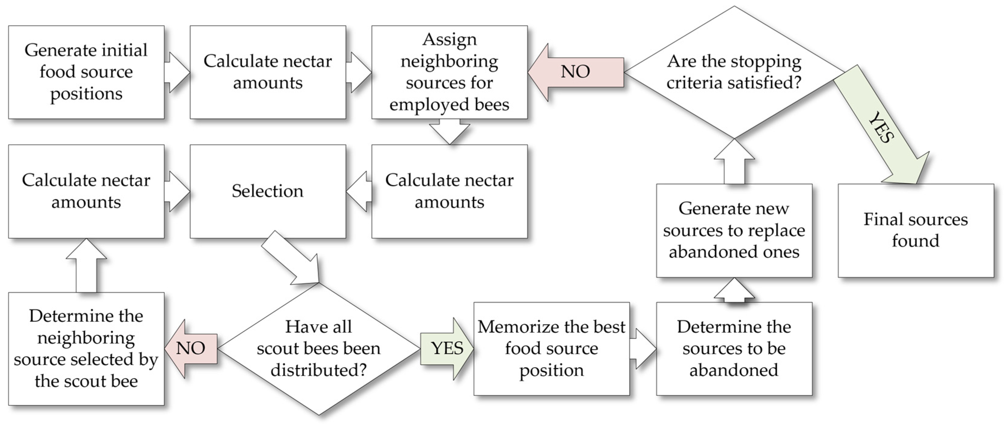
Figure 1. Theoretical workflow of the ABC algorithm (Source: Author’s own elaboration based on Karaboga [75]).
Applsci 14 12076 g001
Figure 2. 2022 satellite image of the study area, illustrating parking challenges and high traffic density. (Source: Google Earth (© 2024 Maxar Technologies)).
Applsci 14 12076 g002
Figure 3. Overview of the volunteers’ buildings and the monitored area: (a) The buildings where the cameras were installed, showing their strategic positioning for monitoring the parking area; (b) An example image captured by the cameras, depicting the monitored area and parking conditions (Source: Author’s own elaboration).
Applsci 14 12076 g003
Figure 4. Map of the study area, showing the extent of parking coverage captured by the cameras and the reference points used for transformations. (Source: Author’s own elaboration).
Applsci 14 12076 g004
Figure 5. Training and validation loss and precision trends across 120 epochs. Early stopping at epoch 87 ensures optimal precision and prevents overfitting (Source: Author’s own elaboration).
Applsci 14 12076 g005
Figure 6. Flowchart depicting the process for identifying optimal parking spaces using the ABC algorithm (Source: Author’s own elaboration).
Applsci 14 12076 g006
Figure 7. Optimally placed cars using the ABC algorithm for different iteration counts: (a) Displays the result after 5 iterations, showing the initial optimal car placements; (b) Shows the result after 500 iterations, representing the final optimal car placements (Source: Author’s own elaboration).
Applsci 14 12076 g007
Figure 8. Pseudo-code of the proposed optimization approach (Source: Author’s own elaboration).
Applsci 14 12076 g008
Figure 9. Optimization performance for a sample application (Source: Author’s own elaboration).
Applsci 14 12076 g009
Figure 10. System architecture for parking monitoring and management: diagram of dependencies between components (Source: Author’s own elaboration).
Applsci 14 12076 g010
Figure 11. The SPARK mobile user interface (Source: Author’s own elaboration).
Applsci 14 12076 g011
Figure 12. Data flow diagram for the parking management system (Source: Author’s own elaboration).
Applsci 14 12076 g012
Table 1. Summary of average performance metrics for YOLOv9e Seg car detection and SPARK parking spot detection, calculated for 120 pairs of test images (Source: Author’s own elaboration).
Detection MethodMetricRangeMeanStandard Deviation
YOLO9eseg (car)Precision *1(0.923, 1.000)0.9280.016
Recall(0.667, 1.000)0.8840.064
Accuracy(0.632, 1.000)0.8950.069
SPARK (Parking Spot)Precision *2(0.667, 1.000)0.8910.053
Recall *3(0.000, 1.000)0.8830.122
Accuracy(0.000, 1.000)0.8730.133
*1 Precision = 1 consistently when there are no false positives; *2 Precision = 1 when all detected spots were correct with no false positives; *3 Recall = 0 when there were 4 manual parking spots but no automated spots.
Disclaimer/Publisher’s Note: The statements, opinions and data contained in all publications are solely those of the individual author(s) and contributor(s) and not of MDPI and/or the editor(s). MDPI and/or the editor(s) disclaim responsibility for any injury to people or property resulting from any ideas, methods, instructions or products referred to in the content.