Abstract
Laizhou Bay Sag is a typical continental rift lake basin, which is affected by strike–slip activity, salt rock activity, volcanic activity, and paleoclimate change in the Tanlu fault zone, where three major lithologies—volcanic rock, clastic rock, and evaporite—mainly develop. In order to determine the sequence correspondence between the different lithologies in the study area based on drilling, logging data, and seismic data, it is determined that the fourth member of the Shahejie Formation in the southern Laizhou Bay mainly develops three types of sequences: clastic rock type sequences, salt lake type sequences, and volcanic rock/clastic rock type sequences. Two second-order sequence boundaries (SBs3L, SBs4L) and one third-order sequence boundary (SBs4U) were identified, and the principle of three divisions of system tracts (LST, TST, HST) and sedimentary processes in different types of sequences were determined by analyzing the stacking patterns of different sequences. Compared with the previous research results, this study provides a more detailed analysis of the sequence boundary definition of different blocks and different lithologic strata, and it improves the previous general sequence stratigraphic division method. Based on the study of distinct types of sequences, a unified stratigraphic framework is established in the whole zone, and the stratum thickness distribution of the fourth member of Shahejie Formation is smaller in the southwest and larger in the northeast. The study area is generally filled with pyroclastic rocks–evaporite–clastic rocks, changing from fan delta–saline lake filling to braided river delta–freshwater lake–fan delta filling from bottom to top. A sequence stratigraphic model for the comparison of steep slope–gentle slope differences is established to provide guidance for future oil and gas field exploration and development.
1. Introduction
Volcanic rocks, evaporites, and clastic rocks deposited in the same stratum indicate information about climatic conditions, marine environment, topography, and geomorphology during the sedimentary period of the stratum. It is an important rock combination for global oil and gas exploration. At the same time, sequence research on different rocks developed in the same stratum has been a research hotspot in recent years [1,2]. The southern part of Laizhou Bay, located in the Laizhou Bay Sag in the southern Bohai Sea, is a typical continental rift lake basin [3] and is a symbiotic sedimentary area of volcanic rock, evaporite, and clastic rock [4,5,6]. The Shahejie Formation is a key stratum of oil and gas exploration [7]. In recent years, more than 20 wells have been drilled in this zone, and many large oil fields have been discovered one after another, further showing that the southern part of Laizhou Bay still has great exploration potential [8]; therefore, predecessors have conducted much research on the Laizhou Bay Sag.
Feng B. identified and divided the isochronous sequence stratigraphic interface of the Paleogene Shahejie Formation, established the sequence stratigraphic framework, and then constructed a sedimentary model of “paleogeomorphology–fault–salt structure–sedimentary body–sand control [9]”. Based on the sequence division of the Laizhou Bay Sag and the exploration of the fault system in the study area, Zheng Y. L. determined that the strike–slip fault zones controlled the formation of sedimentary facies and the injection of eastern provenance [10]. By studying the structural characteristics and genetic mechanism of the slope belt in the Laizhou Bay Sag, Zhao D. J. et al. summarized the evolution model of the slope belt with the “frequent transformation of slope uplift and tilting of strata [11]”. Niu C. M.’s research showed that the Paleogene high-quality reservoirs in the southern Bohai Sea greatly differ under the influence of multistage volcanic activities [12]. Tian L. X. et al. confirmed the existence of volcanic activity in this area through their study on the siliceous clastic rocks of the Shahejie Formation in the Laizhou Bay Sag [13]. The previous research results reveal that most of the studies are aimed at local areas or a certain interval, and no unified sequence division and correlation scheme have been formed in the whole area. The development intervals and areas of different sequence types have not been carefully defined, which restricts the establishment of a unified sequence stratigraphic framework in the whole area and the summary of the filling evolution law in sequence strata. At present, the primary research difficulties are that the joint influence of the strike–slip activity, salt rock activity, and volcanic activity of the Tanlu fault zone has a large degree of stratum deformation and denudation thickness, and the sequence development of different structural units is varied. Frequent structural activities and less drilling data hinder stratigraphic correlation. The identification standard of the key sequence interfaces of the Shahejie Formation has not been unified, and the development characteristics of the sequence strata are not clear.
The sequence stratigraphy study of the volcanic rock–evaporite–clastic rock symbiotic system is more complicated mainly because the particularity of sedimentation principle and the diversity of the superposition relationship affect the definition of the sequence boundary [14,15]. In the continuous sedimentary strata, the conversion surface of the progradation–degradation stacking mode of the parasequence set in the vertical direction and its corresponding sedimentary discontinuity surface in the paleo uplift edge area in the horizontal direction are some of the main bases for the identification of the sequence interface [16,17,18]. In this paper, the fourth member of the Shahejie Formation in the south of the Laizhou Bay Sag was taken as the study object considering the theoretical guidance of the sequence stratigraphy, structural geology, classical sedimentology, and seismic sedimentology; the structural evolution law and sedimentary strata development characteristics in the study area; and the core, drilling, logging, and seismic data, according to the different lithology of sediments in different areas as the principle of dividing the study area. The sequence types in the study area were divided by the principles of zoning research and overall correlation. Next, the sequence boundaries were identified, the sequence stratigraphic superposition patterns and system tract changes were summarized, a unified well–seismic isochronous stratigraphic framework was established, the temporal and spatial distribution range of diverse types of sequences was determined, the unique sequence stratigraphic development model in the study area was established, and the strata depositional evolution was analyzed. This study helps to clarify the sequence characteristics in the southern part of Laizhou Bay, deepen the understanding of the stratigraphic development law, and provide reference for future oil and gas exploration in the Shahejie Formation in the southern part of Laizhou Bay.
2. Geological Conditions of the Study Area
Located in the south of the Bohai Sea, the Laizhou Bay Sag is sandwiched by the east and west branches of the Tanlu strike–slip fault and is a Cenozoic sag developed on the Mesozoic basement. Adjoining the Huanghekou Sag, the Qingdong Sag, and the Miaoxi Sag, this sag extends to the Ludong Uplift in the east, the Weibei Uplift in the south, the Kendong Uplift in the west, and the Laibei Low Uplift in the north, with a total area of about 1780 km2 [19,20]. The study area is located in the south of the Laizhou Bay Sag, with an area of about 920 km2. The sag mainly includes five secondary structural units: the eastern strike–slip zone, the northern depression, the central structural zone, the southern subdepression, and the southern gentle slope belt (Figure 1).
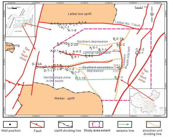
Figure 1.
Study area geographical location.
The basin-controlling faults developing in the south of the Laizhou Bay Sag mainly include the fault system composed of the east branch of the Tanlu strike–slip fault and its branches, the Laibei Number 1 main fault zone with a steep slope in the north, and the Laibei low uplift fault on the west side of the northern depression. The basin-controlling faults in the south of the Laizhou Bay Sag are mainly composed of secondary faults and tertiary secondary faults, which form the Lainan fault system (Figure 2) [21,22]. These faults are mainly characterized by high activity intensity and long activity time, which greatly affects the internal pattern of the whole sag. The Mesozoic, Paleogene Kongdian Formation (Ek), the Shahejie Formation (Es), the Dongying Formation (Ed), the Neogene Guantao Formation (Ng), the Minghuazhen Formation (Nm) and the Quaternary Plain Formation (Qp) are successively developed from bottom to top in the Bohai Bay Basin. Among them, the Shahejie Formation can be divided into four sections, the Dongying Formation can be divided into three sections, and the Guantao Formation and the Minghuazhen Formation can be divided into upper and lower sections. There are volcanic rocks in the Paleogene of Dongying Sag, the Huimin Sag and the Liaoxi Sag in the Bohai Bay Basin. A large number of volcanic rocks were found in the Cenozoic of Bozhong area of the Huanghekou Sag and the D structure area of the Laizhou Bay Sag. Compared with the Qingdong Sag and the Miaoxi Sag, the distribution range of the Shahejie formation in the Laizhouwan Sag is large and the thickness is thick, which is in unconformity contact with the underlying Kongdian Formation. The development range of the second member of Kongdian Formation is small, and the fourth member, the third member, the second member and the first member of Shahejie Formation are successively developed from bottom to top. According to the drilling and seismic reflection characteristics, the fourth member of Shahejie Formation is divided into two parts: the upper sub-member and the lower sub-member. The fourth member of the Shahejie Formation (E2s4) is a set of alluvial fans to saline lake and shallow lake deposits. Coarse clastic rocks with mudstone and blue-gray mudstone are developed. Gray-white salt rock and gypsum layers are mainly intercalated with dark gray argillaceous dolomite and a small amount of gray and purple mudstone. Gray, dark gray, and brown-gray mudstone are mainly intercalated with sandstone and oil shale of carbonate rocks. The mudstone strata in the middle and upper parts are regionally stable source rocks. The third member of the Shahe Formation (E2s3) is a set of deep lake and semi-deep lake to shore-shallow lake delta deposits; a large set of dark mudstone, oil shale with a small amount of sandstone, and the upper sand and mudstone are interbedded, which makes a good reservoir. The third member of the Shahe Formation and the underlying strata are cut unconformably at the slope. The second member of the Shahe Formation (E2s2) is a set of shore-shallow lake delta and river marsh facies deposits. This section develops sandstone with mudstone, gray-green and gray-brown mudstone, and medium-coarse sandstone interbedded. The sandstone layer is a good reservoir. The first member of the Shahe Formation (E2s1) is shallow lacustrine mudstone, fine sandstone and carbonate rock, and the bottom is bioclastic limestone. The thickness is relatively stable, and it is a good cap rock development section (Figure 2) [23,24,25].
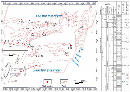
Figure 2.
Fault plane distribution in the southern part of Laizhou Bay (Modified by [23]) and a comprehensive stratigraphic histogram of Laizhou Bay (modified from [24]). The red box is to highlight the focus of this paper on sequence stratigraphy.
3. Data and Methods
This study is based on 3D seismic interpretation data and well logging. The logging data are derived from 23 wells in the study area, which are mainly distributed in the five structural units of the eastern strike-slip zone, the northern depression, the central structural zone, the southern sub-depression, and the southern gentle slope belt. Logging data include natural gamma ray (GR), spontaneous potential (SP), shallow investigate double-lateral resistivity log (RS), deep investigate double-lateral resistivity log (RD), and lithology information, using the LAS file format. The 3D seismic data mainly covers 560 km2 and uses the SGY format with a seismic resolution of 10 m.
The main research methods of this paper are divided into three parts. The first part analyzes the sequence stratigraphy, mainly to interpret the seismic data. The typical seismic lines (line No. 3151, No. 3251, No. 3611) passing through the southern sub-depression and the northern depression are selected for fine seismic interpretation and seismic reflection characteristics identification. Combined with logging information, a well-seismic combination is carried out. The sequence boundaries of the different types of sequences are identified by seismic reflection termination, logging curve shape change, and lithology transformation. The fourth member of the Shahejie Formation is divided into one second-order sequence, and two third-order sequences are divided into the upper fourth member (SQS4U) and the lower fourth member (SQS4L). Through the division of system tracts and the analysis of the stratigraphic sedimentary processes through the sequence stratigraphic superposition patterns of different types of sequences, a unified third-order sequence stratigraphic framework is finally established and the stratigraphic distribution law is analyzed in combination with the stratigraphic thickness map. The second part establishes the sequence development model and discusses the sedimentary evolution process of the strata through the comprehensive analysis of the stratigraphic superposition pattern, paleoclimate change, volcanic activity and paleogeomorphological characteristics. The third part, on the basis of the first two steps of analysis combined with seismic reflection characteristics and structural characteristics, predicts favorable reservoir targets in the study area and deepens the practical significance of this study.
4. Sequence Stratigraphic Analysis of Volcanic Rock–Evaporite–Clastic Rock Symbiotic Zone
According to different sequence classification standards, the sequence types are quite different. Chen Xianliang [26], Ji Youliang [27], Huang Jinding [28], Liu Chang [29] and so on have divided the sequence types of continental basins. In this study, through the characteristics of stratigraphic superposition pattern, seismic reflection structure, provenance supply, paleoclimate change, and tectonic activity, three sequence types of clastic rock sequence, salt lake sequence, and volcanic rock-clastic rock sequence were divided in the study area.
4.1. Clastic Rock Sequence
The clastic rock sequence is mainly developed in the strike–slip zone in the eastern part of the lake basin in the lower sub-member of the fourth member of the Shahejie Formation and the marginal area of the lake basin in the upper sub-member. The development background of the clastic rock type sequence is that the contrast intensity of the basin landform is weakened, the source supply outside the basin is enhanced, and the sediment transport distance is increased.
4.1.1. Sequence Interface Identification of Clastic Rock Types
The Bottom Sequence Interface of the Shahejie Formation
The second-order sequence interface SBS4L corresponds to the stratigraphic interface between the fourth member of the Shahejie Formation and the Kongdian Formation. The lower sub-member sequence of the fourth member of the Shahejie Formation is not drilled in the study area but is drilled in the center of the lake basin. Its development range in the study area is small, and it is mainly deposited in the southern and northern depressions. SBS4L is a continuous seismic reflection with strong amplitude–moderate difference on the seismic profile. According to the seismic reflection characteristics, the SBS4L interface has an obvious truncation phenomenon to the lower Kongdian Formation, and the upper Shahejie Formation overlaps on the interface downward (Figure 3).
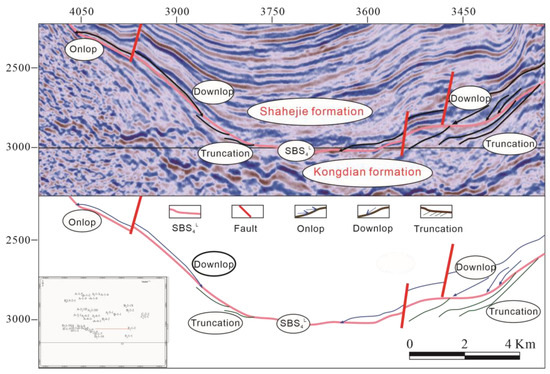
Figure 3.
SBS4L seismic sequence interface identification (3251).
SBS4U Sequence Interface
SBS4U corresponds to the third-order sequence interface of the stratigraphic interface between the upper and lower sub-members of the fourth member of the Shahejie Formation. The sequence interface is identified by logging data. Under the interface is yellow sandstone with a thin mudstone deposition, and the natural gamma curve is serrated. Above the interface, thick mudstone is deposited with thin sandstone, the natural gamma curve is box–finger–micro tooth-shaped, and the overall characteristics change from strong progradation to retrogradation, reflecting the water depth shift from shallow to deep. The interface corresponds to the abrupt change of the lithology and logging curve response (Figure 4). The SBS4U seismic profile shows strong amplitude–good continuous seismic emission, with evident upper super-reflection characteristics above the interface of the southwest gentle slope belt, and the truncation contact with the lower sub-member of the fourth member of the Shahejie Formation can be observed below the interface of the eastern steep slope belt (Figure 5).
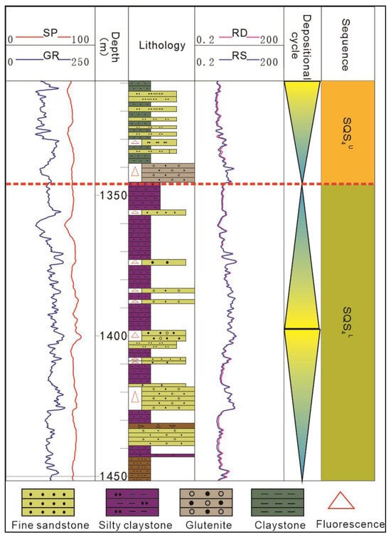
Figure 4.
SBS4U drilling sequence interface identification (D-1-8).
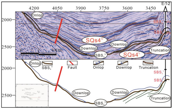
Figure 5.
SBS4U seismic sequence interface identification (3151).
SBS3L Sequence Interface
The second-order sequence interface SBS3L corresponds to the stratigraphic interface between the third and fourth members of the Shahejie Formation. Below the interface of the eastern strike–slip structural belt, the sheet sand sedimentation of brown-gray mudstone mixed with thin sandstone in the upper sub-member of the fourth member of Shahejie Formation is observed. The logging curve is zigzag overall. Above the interface, brown-gray mudstone sedimentation of the lower sub-member of the fourth member of the Shahejie Formation can be seen; the overall logging curve shows a box shape, presenting a depth change of water from deep to shallow; and the transition of the sedimentary environment is embodied above and under the interface (Figure 6). On the seismic profile SBS3L, strong vibration amplitude–good continuous seismic reflection is manifested, the whole zone develops completely, the truncated reflection evidently terminates near the interface in the upper sub-member of the fourth member of the Shahejie Formation under the interface at the center of the lake basin, and lower super-reflection characteristics appear in the lake basin center and steep slope belt above the interface. In addition, upper super-reflection characteristics are presented near the interface in the lower sub-member of the third member in the gentle slope belt, reflecting a large plane of unconformity of the third and fourth members of the Shahejie Formation (Figure 7).
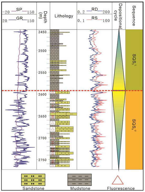
Figure 6.
SBS3L drilling sequence interface identification (E-1-2).
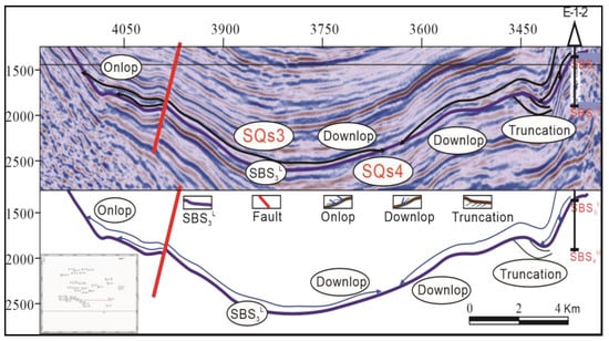
Figure 7.
SBS3L seismic sequence interface identification (3151).
4.1.2. Stratigraphic Superposition Pattern of Clastic Rock Sequence
By studying the specific superposition patterns of quasi-sequence strata in the gentle slope–steep slope differential clastic sequence, the correlation between the quasi-sequence strata was analyzed, and then the division criteria for three subsystem tracts in the sequence were determined, namely, the lowstand system tract (LST), the lake transgressive system tract (TST), and the highstand system tract (HST).
In the fourth member of the Shahejie Formation, the characteristics of the stratigraphic parasequence sets in the gentle slope zone are retrogressive, and the bottom-up stratigraphic superposition pattern is the underwater distributary, channel-distributary, channel-shore shallow lake of the braided river delta front, which is located in the braided river delta front-shore shallow lake zone. (Figure 8). During the LST, the lake level was low, and the water body was shallow and was mainly composed of tuffaceous glutenite sedimentation. During the TST, the lake level rose, the water body deepened, a large set of oxidized mudstone and siltstone was deposited, and the particle size became finer. During the HST, the lake level shrank, evaporated, and became shallow again, showing weak progradation with the development of argillaceous limestone, and the sedimentary environment changed from the front of the braided river delta to the shallow lake, presenting an overall clastic (delta–lake) stratigraphic superposition pattern.
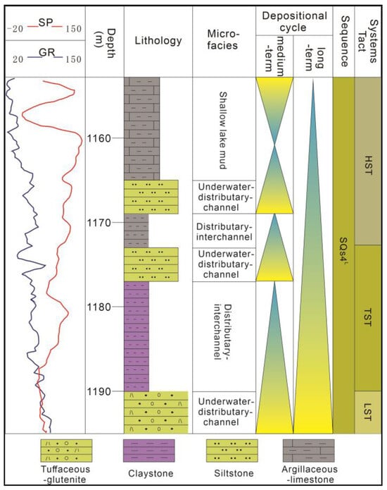
Figure 8.
Clastic stratigraphic overlay pattern (de-united) (D-1-8).
4.2. Volcanic–Clastic Sequence
The volcanic rock–clastic rock sequence is a set of sedimentary strata developing in the early stage of basin extension, with gradually enhanced geomorphologic contrast, less supply of materials outside the basin, and dry climate conditions. It is characterized by multistage, intermittent volcanic eruption, mainly developing in the volcanic activity area in the southwest gentle slope belt of the lower sub-member of the fourth member of the Shahejie Formation. The volcanic activity in the early LST was intense, which made pyroclastic rocks the dominant material source in this period, and the material source supply was sufficient. However, the sedimentary accommodation space and lake area were small, which resulted in the development of the fan delta sedimentary system. During the period of lake TST, the lake level rose, the water body deepened, volcanic eruption was intermittent, and normal sedimentation developed. During HST, the volcano erupted again, developing alternately with the proximal caving phase and the thermal debris flow phase.
4.2.1. Identification of the Volcanic–Clastic Sequence Interface
The gentle slope belt in the south of the Laizhou Bay Sag penetrated the bottom interface of the lower sub-member of the fourth member of the Shahejie Formation. Because of the serious stratum erosion and the inconspicuous seismic reflection characteristics in the southern gentle slope belt, the sequence interface between volcanic rocks and clastic rocks was identified according to the rock–electricity change characteristics. SBS4L serves as the interface between the volcanic–clastic sequence of the lower sub-member of the fourth member of the Shahejie Formation and the underlying strata. The basement below the sequence interface is gray andesite tuff, and reddish-brown mudstone appears above the interface. SBS4U is the interface between the pyroclastic sequence of the lower sub-member of the fourth member of the Shahejie Formation and the normal sedimentary clastic sequence of the upper sub-member. The lithology of the lower sub-member of the fourth member of the Shahejie Formation is brown tuffaceous glutenite under the sequence interface and yellow argillaceous medium sandstone above the interface. The response value of the natural gamma curve suddenly changes from high to low, accompanied by clear sequence interface characteristics (Figure 9).
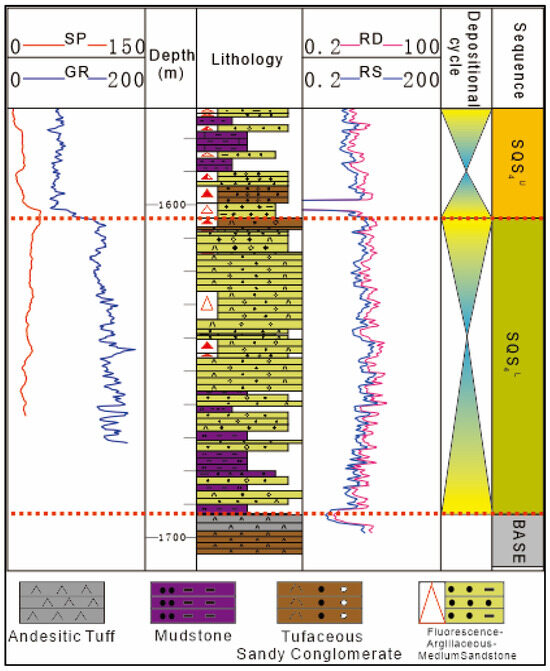
Figure 9.
Volcano-clastic drilling sequence interface identification mark (D-1-9).
4.2.2. Volcanic Rock–Clastic Rock Superposition Pattern
The volcanic rock–clastic rock sequence mainly developed in the volcanic activity area in the southwest gentle slope belt of the Laizhou Bay Sag. During the LST, the early volcanic activity energy was strong, the volcanic debris flow in the explosive phase was dominant, and the lithology changed from tuffaceous sandstone to silty mudstone and tuffaceous volcanic breccia–tuffaceous sandstone. The stratigraphic superposition pattern can reflect the sedimentary process of strata under volcanic activity and then reflect the volcanic activity from strong to weak, and the whole is dominated by the volcanic debris flow of explosive facies. The lacustrine TST was in the volcanic intermission, volcanic activity stopped, and normal sediments developed. The lithology of gravelly fine sandstone–silty mudstone–gravelly fine sandstone changed, and the grain size of the sediments shifted from coarse to fine and to coarse again, reflecting the fact that water body was gradually deepened and then deepened once again. During the period of HST, the volcanic activity continued, including the coarsening to refining of tuffaceous conglomerate–tuffaceous sandstone and the volcanic change from proximal caving to thermal debris flow, proving that the volcanic activity experienced three complete periods at this time, and the logging curve had no evident response during the volcanic activity. Based on the analysis of the pyroclastic sequence stratigraphic superposition pattern, the volcanic activity in the southwest gentle slope belt of the Laizhou Bay Sag can be divided into five periods, in which the LST contains one volcanic activity period, the lake TST is a volcanic intermittent period, and three volcanic activity periods develop in the HST. Overall, this sequence shows a proximal caving–pyroclastic flow superposition pattern (Figure 10).
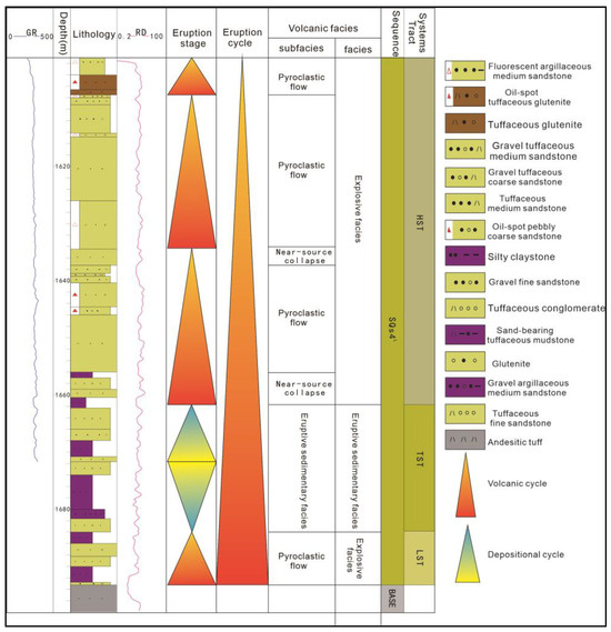
Figure 10.
Volcano-clastic drilling sequence interface identification mark (D-1-4).
4.3. Saline Lake Sequence
The saline lake sequence mainly developed in the period of intense stretching of the lake basin, the large-scale tilting of the basement, the flattening of the stratum in the sag, and an arid climate background, during which the lake area was small and the water depth was shallow. The saline lake sequence mainly exists in the fourth member of the Shahejie Formation in the lake basin. According to the different stratigraphic superposition patterns and seismic reflection types in the sequence, it can be divided into two types: the gypsum saline lake sequence in the lower sub-member of the fourth member of the Shahejie Formation and the carbonate lake sequence in the upper sub-member.
4.3.1. Identification of Saline Lake Sequence Interface
SBS4L is the interface between the saline lake sequence in the center of the lake basin and the underlying strata. In the seismic profile, a medium amplitude–medium continuous seismic reflection is reflected, chaotic reflection characteristics are observed below the interface, and a medium continuous–weak seismic reflection appears above the interface. The seismic reflection characteristics above and below the interface are quite different, the underlying strata are truncated near the interface, and the lower super-reflection characteristics can be seen in the transition zone from the gentle slope belt above the interface to the center of the lake basin (Figure 11).
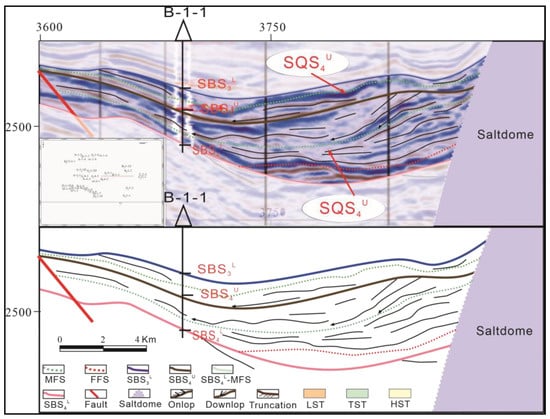
Figure 11.
Salt lake sequence seismic interface identification and internal reflection structure characteristics.
SBS4U is the interface between the carbonate lake sequence in the upper sub-member of the Shahejie Formation within the saline lake sequence and the gypsum saline lake sequence in the lower sub-member of the fourth member of the Shahejie Formation. Below the interface, gypsum salt sedimentation of white gypsum rock is found with box-shaped natural gamma curves, while above the interface, deep lake mud sedimentation of white mudstone is observed, with zigzag natural gamma curves. The upper and lower resistivities of the interface suddenly change from low to high and the sediments are gradually refined, reflecting the water deepening. The sequence interface corresponds to the lithologic abrupt change surface of drilling (Figure 12a). On the seismic profile, SBS4U is a medium-strong amplitude–good continuous seismic reflection, and above the interface, it is characterized by medium-strong amplitude–good continuous parallel and subparallel seismic reflection. The sequence interface in the center of the lake basin experiences evident erosion on the lower gypsum saline lake formation, the lower super-reflection characteristics can be seen above the interface, and evident upper super-reflection is found in the lower sub-member of the third member of the Shahejie Formation above the interface of the gentle slope belt (Figure 11).
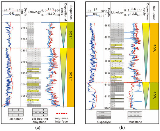
Figure 12.
Identification of the salt lake rock–electrostrata–sequence interface (B-1-1): (a) SBS4U drilling sequence interface identification mark; (b) SBS3L drilling sequence interface identification mark.
SBS3L is the second-order sequence interface between the saline lake sequence of the fourth member of the Shahejie Formation and the freshwater clastic sequence strata of the third member of the Shahejie Formation. Under the sequence interface, carbonate beach sedimentation of white limestone is found, and above the interface, lacustrine mud sedimentation of white mudstone is seen. The natural gamma curve changes from low to high, and the resistivity presents the opposite trend. The lithologic conversion above and below the interface is evident, the sudden change features of the logging curve response are apparent, and the sequence interface is clear (Figure 12b). The seismic profile shows that SBS3L is a medium-weak amplitude–good continuous seismic reflection axis, and the strata above the interface are characterized by medium-weak amplitude–good continuous-parallel blank reflections. Above the sequence interface, the central part of the lake basin is characterized by a lower super-reflection, while the gentle slope belt exhibits an evident upper super-reflection, and no apparent truncated reflection is below the sequence interface, indicating that the saline lake sequence in the center of the lake basin is in integrated contact with the freshwater lake sequence (Figure 11).
4.3.2. Saline Lake Sequence Stratigraphic Superposition Patterns
The saline lake sequence mainly developed in the center of the southern lake basin in the Laizhou Bay Sag, which was formed mainly due to the paleoclimatic influence. During the period from the lower sub-member of the fourth member of the Shahejie Formation to the upper sub-member, the climate changed from drought to semi-drought, forming two sets of different stratigraphic superposition patterns.
A sulfate lake superposition pattern of progradation-accretion saline lake salt rock–saline lake mud mixed-sedimentation developed in the lower sub-member of the fourth member of the Shahejie Formation. This superposition pattern mainly developed in the center of the northern depression. In the early stage of the LST, the sedimentation of saline lake mud, salt rock, and sandy beach bar was discovered, showing weak progradation overall. Affected by the dry climate, the lake level dropped, the water body became shallow, and the accretion was strong. Dark gray mudstone and thick gypsum rock were superposed in multiple periods. Thick mudstone developed in the lake TST. During the period of HST, large sets of gypsum developed. The sedimentary lithology was gypsum–mudstone–gypsum rock. The sedimentary microfacies of gypsum salt beach–sulfate lake mud–gypsum salt beach reflected the change of the water body from shallow to deep and then to shallow, as well as the change of the LST–lake TST–HST (Figure 13a).
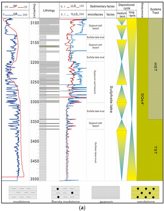
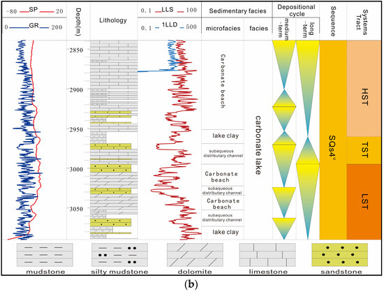
Figure 13.
Salt lake sequence stratigraphic overlay pattern: (a) the paste salt lake sequence stacking style; (b) the carbonate lake sequence stacking style.
A progradation–retrogression type carbonate rock–clastic rock mixed-sedimentary type superposition pattern developed in the upper sub-member of the fourth member of the Shahejie Formation, which formed under the sedimentary environment of carbonate lake in the center of semiarid lake basin. In the early stage of the LST, lake mud and an underwater distributary channel developed and showed progradation characteristics; in the lake TST, the water body became shallower with the lake level descending; mudstone and carbonate rocks began to develop in the late stage of the LST; and sandstone, mudstone, and carbonate rocks were deposited alternately. During the period of the lake TST, the lithology changed from the limestone of the underwater distributary channel to mudstone, and the sediments in the underwater distributary channel turned into lake mud, which reflected the rising water body. During the HST, the lake level dropped again. Carbonate beach and thick limestone sedimentation developed, changing from percarbonate beach bar–underwater distributary channel progradation to carbonate beach bar–lake mud retrogradation, and later to lake mud–carbonate beach bar progradation. The lithological changes of limestone–mudstone–limestone under the shallow lake–carbonate lake mud–carbonate beach bar stratigraphic stacking and superposition pattern reflected the shallowing of the lake level and the change of the LST–lake TST–HST (Figure 13b).
4.4. Sequence Stratigraphic Framework
Based on the analysis of the different types of sequences in different blocks, the sequence interpretation of key survey lines was determined by selecting representative cross-well sections that ran through the whole zone to clarify the sequence correlation of the work area further, determine the well-seismic correlation relationship of the sequence, and establish a unified sequence stratigraphic framework of the volcanic rock–evaporite–clastic rock symbiotic zone. The third-order sequence interface was identified in the fourth member of the Shahejie Formation through well-seismic integration, the stratigraphic superposition pattern, and rock–electric response characteristics, and then two third-order sequences and six system tracts were divided (Figure 14) and combined with the thickness map of the fourth member of the Shahejie Formation in the south of Laizhou Bay, the stratigraphic distribution law in the stratigraphic framework is analyzed (Figure 15).
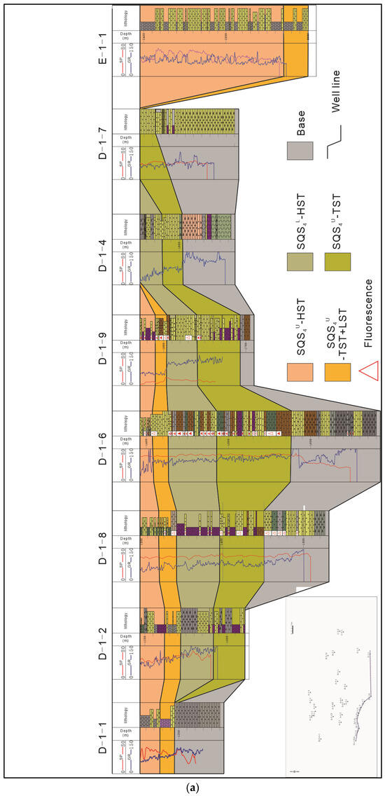
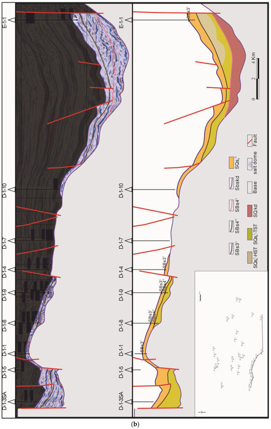
Figure 14.
The isochronous sequence stratigraphic framework of the study area: (a) southern slope zone–southern sub-depression-eastern slip zone connected well profile; (b) seismic interpretation profile of the southern slope zone–southern sub-depression-eastern slip zone.
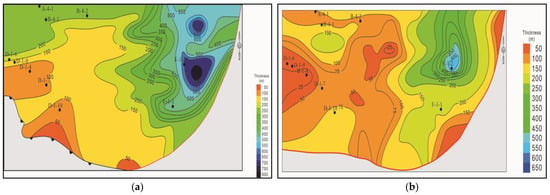
Figure 15.
The stratigraphic distribution map of the study area: (a) thickness map of the SQS4L formation in the southern Laizhou Bay depression; (b) thickness map of the SQS4U formation in the southern Laizhou Bay depression).
During the SQS4L sequence period, influenced by volcanic activities, the sequence developed in the southern gentle slope belt in a small range, belonging to a composite sequence composed of volcanic rocks and sedimentary rocks. Volcanic rocks were deposited near the strike–slip zone in the west, which were far from volcanic sources and were less affected by volcanic activities. Due to shallow water bodies, sedimentary strata were exposed from the water surface and subjected to denudation, thus developing incompletely, and the eastern strike–slip zone was dominated by clastic rock sedimentation. The seismic profile revealed thick saline lake sequence stratigraphic sedimentation in the southern subdepression, presenting poorly continuous–weak amplitude seismic reflection characteristics. The lake TST in this well profile was relatively thin, but its thickness was stable. Mudstone sedimentation played a dominant role, intermingled with a small amount of thin sandstone; the lake level rose; and the water body deepened. The thickness of the HST increased gradually from west to east, and it was denudated around Well 4 in D structural belt.
Compared with SQS4L, the SQS4U sequence is thinner overall, but the formation thickness is stable, with good east–west connectivity and strong comparability. On the gentle slope belt, the strata in the denudation area at the elevated position are generally thin. The strike–slip zone in the east is close to the sedimentary center, the stratum is thick and proximal with a short sediment transport distance, and thick sandstone and mudstone are interbedded. Overall, the stratum in the east is thick, the onlap phenomenon is pinched out on the slope belt, the stratum in the west is supplied by distal sources, and it is thin in the higher terrain area. The system tract is underdeveloped; the HST is denudated in the elevated position, namely, at Well 4 in the D structural belt; and the TST stratum is thin. Thick carbonate lake sequence stratigraphic sedimentation is found in the center of the southern subdepression, and the TST stratigraphic thickness in other areas is thickened. The thickness of the HST formation is the largest. The phenomenon of onlap pinch-out can be seen on the gentle slope, and the eastern strike–slip zone is dominated by clastic rock sedimentation.
5. Sequence Development Model and Depositional Evolution
5.1. Sequence Development Model
Under the control of different basin structures, the sequence stratigraphic development models are quite different [30]. Based on the comprehensive analysis of the structural evolution, slope break zone identification, lake basin structural characteristics, sequence types, and sequence stratigraphic development and evolution process characteristics of the southern Laizhou Bay Sag, a sequence stratigraphic development pattern for the comparison of steep slope–gentle slope differences in the volcanic rock–evaporite–clastic rock symbiotic zone of the Shahejie Formation in the southern Laizhou Bay Sag was established (Figure 16). The terrain gradient in the southwest gentle slope belt in the south of the Laizhou Bay Sag was slow, and the range of the slope break belt was wide. Influenced by the tectonic activities of faults, different ancient landforms with steep slopes and gentle slopes were formed in different regions, thus controlling the development of the sedimentary facies zones in different regions, mainly including fan delta, braided river delta, and lake facies sedimentation. In this paper, according to the corresponding relationship between the lacustrine facies, seismic data, and logging data, it can be divided into shore-shallow lacustrine facies and semi-deep lacustrine-deep lacustrine facies. The shore-shallow lacustrine facies is mostly located in the open zone, which is mainly located at the edge of the basin in the study area. The semi-deep lacustrine-deep lacustrine facies is mainly located in the center of the lake basin in the study area. The semi-deep lacustrine-deep lacustrine is in a deep hydrostatic environment; the fan delta facies is formed in the steep slope zone in the eastern part of the study area. The overall continuity is good, the internal amplitude has good continuous progradation reflection characteristics, and the external geometry is a high angle progradation body. The braided river delta facies is mainly developed in the southwest gentle slope zone of the upper part of the fourth member of the sand. It is characterized by an S-type oblique progradation reflection and a low-angle oblique progradation reflection, and the external geometry is a low-angle ‘triangle.‘ The gentle slope part of the sequence development model was mainly in the structural uplift belt in the southern part on the western margin of the Shahejie Formation basin in the Laizhou Bay Sag. In the gentle slope break belt, multistage step-broken characteristics were presented. The sequence stratigraphic model in this area was mainly characterized as follows: In the lower sub-member of the fourth member of the Shahejie Formation, the tectonic subsidence speed was slower than the sediment supply speed, which led to the rapid forward movement and accumulation of sediments, and a delta was formed on the slope break belt; during the advance to the interior part of the lake basin, the sedimentary system characterized by eruption–proximal sedimentation–distal clastic sedimentation developed in the middle-stand system tract and LST, while the lake TST was characterized by muddy sedimentation of semi-deep lake-deep lake facies. During the HST, braided river delta sedimentation developed as the main feature, with the following specific characteristics:
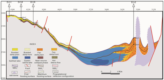
Figure 16.
Steep-slope–gentle slope differential contrast sequence stratigraphic model.
① On the side of the gentle slope belt, many faults with different inclination directions developed.
② During the sedimentary period of the LST of the lower sub-member of the fourth member of the Shahejie Formation, the stratum was denudated seriously and only existed in the low part of local sedimentation, which was manifested by the thin stratigraphic sedimentation, and river channel filling dominated.
③ The lake TST was dominated by shore–shallow lake–deep lake facies argillaceous sedimentation, and the stratigraphic sedimentary thickness gradually increased from the gentle slope break belt to the interior of the basin.
④ The HST presented shallow lake and delta sandstone sedimentation within the slope break belt and shallow lake–semi-deep lake facies argillaceous sedimentation within the slope break belt.
A steep slope controlled by the east branch of the Tanlu strike–slip fault formed in the east side of the Laizhou Bay Sag. The sequence stratigraphic model is described as follows: In the initial development period of each sequence, the tectonic subsidence was faster than the lake level decline, and the LST in the sequence developed well, mainly manifesting as fan delta sedimentation, while in the TST, semi-deep lake–deep lake facies gray mudstone sedimentation dominated, the basin–edge fan delta sedimentation range receded, and the sedimentation thickness decreased. The HST was mainly characterized by fan delta sedimentation. The sequence stratigraphic development model of this steep slope is mainly located in the east of the Laizhou Bay Sag, along the east branch of the Tanlu strike–slip fault, presenting a nearly north–south distribution. The characteristics are depicted as follows:
① Controlled by the east branch of the Tanlu strike–slip fault, the slope of the east basin margin was high and the inclination angle was large. The system tracts in the basin developed fully, reflected by the development of the LST, the lake TST, and the HST in all intervals.
② The fan delta sedimentation dominated in the LST and HST. The sedimentary thickness was small in the LST but large in the HST. The formation thickness gradually declined from the basin edge to the basin center.
③ In the lake TST, the lake facies semideep lake–deep lake facies sedimentation played a dominant role, the main lithologies were mudstone and sandy mudstone, and fan deltas developed at the edge of the basin, but the sedimentary range was small.
④ Salt–rock activities slightly influenced the sequence development during the sedimentary period of the fourth member of the Shahejie Formation, and the distribution range of fan deltas was large.
5.2. Depositional Evolution
Influenced by basin-controlling faults and the tectonic paleogeomorphology background, the sequence filling model of the continental rift lake basin is controlled by factors such as the characteristics of the sediment source region, the sediment supply channel, the lake level, the basin water body properties, and the basin hydrodynamic types [31,32], showing evident regional differences. Based on the sequence stratigraphic analysis of the study area, the filling evolution law in this zone is discussed.
During the sedimentary period of the fourth member of the Shahejie Formation, the tectonic paleogeomorphology in the southern part of Laizhou Bay exhibited a convex–concave alternating pattern, the western paleogeomorphology displayed a gentle slope, and the southern slope gradually became gentle from east to west, while the eastern edge of the sag was controlled by the north–south Tanlu strike–slip fault and its associated faults, showing a stepped topographic steep slope [33,34]. Influenced by the paleoclimate and tectonic activities during sedimentation, clear differences were observed in the properties of ancient lakes in different periods. During the sedimentary period of the lower sub-member of the fourth member of the Shahejie Formation, the lake water had high salinity and belonged to a saline lake. During the sedimentary period of the upper sub-member of the fourth member of the Shahejie Formation, the saline lake was desalinated due to the semiarid climate. During the development period of diverse types of lakes, the sequence filling of their basins differed. In the development period of the saline lakes deposited in the lower sub-member of the fourth member of the Shahejie Formation, due to the lack of surface runoff supply, the edge of the lake basin was filled with a temporary fan–delta sedimentary system, and the scale of the sedimentary bodies was generally small. Therefore, volcanic activities were frequent in the southwest gentle slope belt of the lake basin, and pyroclastic rocks served as the main source of this area, while most lake areas were mainly filled with evaporite. During the development period of the desalinated saline lake deposited in the upper sub-member of the fourth member of the Shahejie Formation, due to the increase of humid rainfall, the surface runoff increased the recharge of the lake, the erosion of the surface by the water network system developed on land increased, and a large amount of debris eroded on land was brought into the lake, resulting in the sedimentation filling of the large distant braided river delta and the fan delta in the lake. Most of the lake areas were dominated by mudstone sedimentation. Generally, the strata in the study area presented a pyroclastic rock–evaporite–clastic rock sequence mixed sedimentation filling mode (Figure 16).
5.3. Reservoir Properties and Prediction Discussion
Based on the analysis of the sequence stratigraphic characteristics, the establishment of a sequence development model and the discussion of a sequence stratigraphic sedimentary process, combined with the characteristics of seismic reflection, it is found that during the period of the upper high system tract of the fourth member of the Shahejie Formation in the B structural belt, the fan delta in the area received the supply of the eastern source. At this time, the salt rock activity did not affect the formation development. The salt structure pierced the stratum, which blocked the salt rock in the east side of the salt uplift, thickened the lithologic sand body to the east, and over-pinched out in the west. The overall distribution was fan-shaped, and the mudstone–salt rock cap rock combination was formed in the contact area between the fan delta front and the salt lake (Figure 17a). The volcanic activity in the lower part of the fourth member of the D structural belt caused the uplift of the southern gentle slope to form a good volcanic rock block. During the period of the low-stand system tract in the upper sub-member of the fourth member, the braided river delta was formed due to the influence of the western provenance. The lithologic sand bodies were accumulated in the east, and the lithologic bodies were superimposed in a large range in the longitudinal direction. The braided river delta front and the shallow lake mudstone were deposited alternately, forming a good reservoir-cap combination (Figure 17b). The salt rock did not pierce the strata when the fan deltas of the upper high system tract and the low system tract of the fourth member of the Shahejie Formation (Figure 17c) and the lower high system tract and the low system tract of the fourth member of the Shahejie Formation (Figure 17d) in the E structural belt were developed. Its development was affected by the supply of the eastern provenance and the southern provenance at the same time. The later salt rock activity caused the salt rock to pierce the strata and form a salt dome to block and seal, the lithologic sand body was wedged downward and pinched out to the west, and the upper part of the sand body was covered by mudstone. The sand body and the lacustrine mudstone and salt rock form a good source-reservoir-cap configuration. The three structural belts all developed and formed a favorable lithology body, which is expected to achieve better oil and gas discovery.
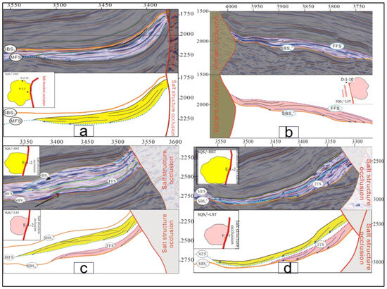
Figure 17.
Favorable trap seismic profile and plane distribution map: (a) B structural belt favorable lithology and plane distribution; (b)D structural belt favorable lithology and plane distribution; (c) the upper high system tract and the low system tract of the fourth member of the Shahejie Formation of E structural belt favorable lithology and plane distribution; (d) the lower high system tract and the low system tract of the fourth member of the Shahejie Formation of E structural belt favorable lithology and plane distribution.
6. Conclusions
Based on the analysis of the sequence stratigraphic superposition patterns, seismic reflection structures, paleoclimate changes, and tectonic activities, the study area was divided into three sequence types: clastic sequence, saline lake sequence, and volcanic–clastic sequence.
According to the different drilling data and seismic reflection characteristics, two second-order sequence interfaces and one third-order sequence interface in the fourth member of the Shahejie Formation were identified in the volcanic–evaporite–clastic symbiotic zone and divided into one second-order sequence, two third-order sequences, and six system tracts. According to the different findings of lithofacies combination, a clastic (delta–lake) stratigraphic superposition pattern developed in the clastic sequence strata. Influenced by volcanic activities, volcanic–clastic sequences mainly developed in the southwest gentle slope belt of the lower sub-member of the fourth member of the Shahejie Formation in the south of Laizhou Bay. According to the change in the lithofacies combination, the proximal caving–thermal clastic flow stratigraphic superposition pattern mainly developed in the volcanic–clastic sequence. According to the energy change and lithologic characteristics, volcanic activities could be divided into five periods, in which the LST was volcanic phase 1, and the lake TST was the volcanic-intermittent period, with normal clastic sedimentation, and three periods of volcanic activities were in the HST. The saline lake sequence mainly developed in the center of the lake basin in the fourth member of the Shahejie Formation, and it was subdivided into the gypsum saline lake sequence in the lower sub-member of the fourth member of the Shahejie Formation and the carbonate lake sequence in the upper sub-member according to different salinization degrees. The sulfate lake superposition pattern of progradation–accretion saline lake salt rock–saline lake mud mixed-sedimentation and the progradation–retrogression carbonate rock–clastic rock mixed-sedimentation type stratigraphic superposition pattern developed.
Based on the study of several types of sequence strata in different blocks, a unified sequence stratigraphic framework was established, and the stratigraphic distribution characteristics were examined under the sequence stratigraphic framework. According to the distribution and evolution of the sequence stratigraphy in the Lainan subdepression, the sequence thickness of the fourth member of the Shahejie Formation in the study area was generally thinner in the southwest, south, and east, and thickest in the middle and northeast. The reflected provenance included three directions: west, south, and east.
Based on the analysis of the sequence stratigraphy, the evolution law of sequence filling was discussed and a unique sequence development model in the study area was established. Generally, the strata in the study area presented a pyroclastic rock–evaporite–clastic rock mixed-sedimentation type filling pattern. Moreover, a sequence stratigraphic model for the comparison of steep slope–gentle slope differences was constructed.
Based on the analysis of sequence stratigraphic characteristics, the filling evolution law, and the establishment of the sequence development model combined with the characteristics of seismic emission, the high-stand system tract of the fourth member of the Shahejie Formation in the B structural belt is found in the study area. The low system tract of the fourth member of the Shahejie Formation in the D structural belt is found in the study area; the high-stand system tract and the low-stand system tract of the upper fourth member of the Shahejie Formation and the high-stand system tract and the low-stand system tract of the lower fourth member of the Shahejie Formation in the E structural belt have well-developed lithological bodies, which can be used as key potential targets for future oil and gas exploration.
Author Contributions
Conceptualization, investigation, writing—original draft, and data curation: C.Z.; methodology, and validation: Y.W.; funding acquisition and formal analysis, S.Z. All authors have read and agreed to the published version of the manuscript.
Funding
This research received no external funding.
Institutional Review Board Statement
Not applicable.
Informed Consent Statement
Not applicable.
Data Availability Statement
All data and materials are available on request from the corresponding author. The data are not publicly available due to ongoing research that is using a part of the data.
Conflicts of Interest
Author Chunhui Zhao was employed by the company China National Offshore Oil Corporation. The remaining authors declare that the re-search was conducted in the absence of any commercial or financial relationships that could be construed as a potential conflict of interest.
References
- Zhang, T.; Zhang, Y.; Jin, X.; Zhou, Y.; Zhang, J.; Gu, N.; Zhang, W.; Wang, R.; Lu, K. Sequence stratigraphy models of carbonate-evaporite successions and their controls on source rocks and reservoirs in the Ordovician Majiagou Formation, Ordos Basin. Oil Gas Geol. 2023, 44, 110–124. [Google Scholar]
- Jamar, B.; Jack, P.; Conn, W. Depositional and stratigraphic architecture of a mixed carbonate–siliciclastic depositional system in the Mississippian (Lower Carboniferous) of the Southern Midcontinent, Oklahoma, USA. Facies 2022, 68, 18. [Google Scholar]
- Qin, Y.; Zhu, X.-M.; Wang, T.; Guo, C.; Xie, S. Forced regression and its sedimentary response to continental lacustrine rift basin: A case of the Member 3 of Shahejie Formation in Laizhouwan sag, Bohai Bay Basin. J. Palaeogeogr. 2020, 22, 457–468. [Google Scholar]
- Abdullah, A.M.; Philippe, R. Sequence stratigraphy and facies analysis of the NE Gondwana Middle Jurassic inner-platform mixed carbonate-siliciclastic succession, Saudi Arabia. Arab. J. Geosci. 2022, 15, 820. [Google Scholar]
- Wallrich, B.M.; Miller, C.F.; Gualda, G.A.R.; Miller, J.S.; Hinz, N.H.; Faulds, J.E. Volcano-pluton connection: Perspectives on material and process linkages, Searchlight pluton and Highland Range volcanic sequence, Nevada, USA. Earth-Sci. Rev. 2023, 238, 104361. [Google Scholar] [CrossRef]
- Meng, F.W.; Zhang, Z.L.; Yan, X.Q.; Ni, P.; Liu, W.H.; Fan, F.; Xie, G.W. Stromatolites in Middle Ordovician carbonate–evaporite sequences and their carbon and sulfur isotopes stratigraphy, Ordos Basin, northwestern China. Carbonates Evaporites 2019, 34, 11–20. [Google Scholar] [CrossRef]
- Zhang, L. Petroleum geological characteristics and hydrocarbon accumulation models of the Kenli A Oilfield, Bohai Bay Basin. Mar. Geol. Front. 2022, 38, 63–70. [Google Scholar]
- Xue, Y.; Yang, H.; Wang, H.; Xu, C.; Sun, X.; An, J. Discovery and significance of KL10-2 Neogene large oilfield in deep subsag zone of Laizhouwan sag, Bohai sea. China Offshore Oil Gas 2022, 34, 17–26. [Google Scholar]
- Feng, B. Study on Sedimentary System of Paleogene Shahejie Formation in Southern Laizhou Bay. Master’s Thesis, Yangtze University, Jingzhou, China, 2019. [Google Scholar]
- Zheng, Y. The Characteristics of Cenozoic Fault System in the Eastern Bonan and Its Control on Sedimentation; China University of Geosciences: Beijing, China, 2020. [Google Scholar]
- Zhao, D.; Yang, H.; Wang, H.; Zhao, Y.; Tu, X. Characteristics of strike slip-extensional complex slope zone andhydrocarbon accumulation in Laizhouwan Sag, Bohai Sea, China. J. Chengdu Univ. Technol. 2022, 49, 272–283. [Google Scholar]
- Niu, C.; Guo, T.; Yang, B.; Liu, Q.; Yang, H. Control of Cenozoic magmatic activity on Paleogene high qualityreservoirs in southern Bohai sea. China Offshore Oil Gas 2019, 31, 11–19. [Google Scholar]
- Tian, L.; Wang, Q.; Liu, X.; Hao, Y. Geological features and their participation in the formation of silicified clastic reservoirs in the Shahejie Formation of Laizhouwan Sag, Bohai Sea. Oil Gas Geol. 2020, 41, 1073–1082. [Google Scholar]
- Qiao, X.; Ding, L.; Rui, Z.; Sheng, G.; Ping, X.; Zhao, X.; Xiao, L. Sequence stratigraphic model of carbonate—Clastic rock symbiosis area of Zhujiang Formation in eastern Pearl River Mouth basin. China Offshore Oil Gas 2021, 33, 47–55. [Google Scholar]
- Wang, M.; Lu, J.; Zuo, Z.; Wang, B.; Li, H.; Zhang, Y. Sequence stratigraphic research of volcanic and clastic sediment basins: A case study of Changling Fault Depression in Songliao Basin. Pet. Geol. Exp. 2016, 38, 796–802. [Google Scholar]
- Salman, A.M. Diagenetic characteristics and sequence stratigraphy on carbonate deposits: A case study from Wadi El Dakhl, West Gulf of Suez, Egypt. Arab. J. Geosci. 2021, 14, 1133. [Google Scholar] [CrossRef]
- Elhossainy, M.M.; Salman, A.M.; Sarhan, M.A.; Al-Areeq, N.M.; Alrefaee, H.A. Sequence stratigraphic analysis and depositional evolution of the Upper Cretaceous deposits in Ras Budran oil field, Gulf of Suez, Egypt. Arab. J. Geosci. 2021, 14, 1104. [Google Scholar] [CrossRef]
- Olayiwola, M.A. Sequence stratigraphy and depositional systems of late Miocene to early Pliocene deep offshore Niger Delta, southeastern Nigeria. Arab. J. Geosci. 2021, 14, 979. [Google Scholar] [CrossRef]
- Zhang, J.; Qin, Y.; Guo, C.; Cui, L.; Li, Z.; Jin, L.; Wang, X. Geological and Geophysical Characterization of the Sedimentary Features on Braided River Delta in the Upper Member 3 of the Shahejie Formation, Kenli Oilfield, Laizhouwan Sag. Geol. J. China Univ. 2021, 27, 515–525. [Google Scholar]
- Liu, C.; Li, W.; Wu, Z.; Zhang, X.; Chen, X.; Li, C. Development Characteristics of the Cenozoic Fault System and Basin Evolution of Bonan Area in Bohai Sea. Geol. J. China Univ. 2016, 22, 317–326. [Google Scholar]
- Shi, W.; Niu, C.; Yang, B.; Wang, L.; Deng, H.; Wang, H.; Zhang, D. Mechanism of “strike-slip-extensional” composite faults-controlled hydrocarbon accumulation in the northeastern Laizhouwan Sag, and its enlightenment for exploration. Oil Gas Geol. 2019, 40, 1056–1064. [Google Scholar]
- Deng, Y.; Liu, C.; Wang, J.; Zhang, D. The activity and post-reformation of Cenozoic Tan-Lu Fault in Laizhou Bay area. Acta Petrol. Sin. 2016, 32, 1197–1205. [Google Scholar]
- Su, S. Study on Reservoir of Paleogene Shahejie Formation in Southern Laizhouwan Sag. Master’s Thesis, Yangtze University, Jingzhou, China, 2019. [Google Scholar]
- Liu, X.; Wang, Q.; Dai, L.; Hao, Y. Relationship between lithofacies characteristics and reservoirs of Mesozoic volcanic rocks in Laizhouwan sag. Pet. Geol. Eng. 2018, 32, 1–6. [Google Scholar]
- Deng, M.; Wang, N.; Li, X.; Chen, R.; Liu, Y.; Xu, Y. Geochemical characteristics and sedimentary environment of source rocks of the third member of Paleogene Shahejie Formation in central Laizhouwan Sag, Bohai Sea. Lithol. Reserv. 2023, 35, 49–62. [Google Scholar]
- Chen, X.; Ji, Y.; Fan, T.; Wang, H.; Yan, N.; Chen, X. Sequence stratigraphic types and models in Lishu rift, Songliao basin. J. Cent. South Univ. 2014, 45, 1151–1162. [Google Scholar]
- Ji, Y.; Zhou, Y.; Wang, G.; Lu, L. Sequence stratigraphic models and reservoir prediction of the Paleozoic marine carbonates in the Lower Yangtze area. Oil Gas Geol. 2011, 32, 724–732, 786. [Google Scholar]
- Huang, J.; Ji, Y. Study on development model of third-order sequence and characteristics of sedimentary system of a representative continental lacustrine subbasin. Shanghai Geol. 2008, 01, 32–36+65. [Google Scholar]
- Liu, C.; Zhang, Q.; Xie, Y.-F.; Qiao, L.; Sun, J.; Mei, X. Sequence Stratigraphic Framework and Development Model of the Cretaceous in Northeast Block, Oriente Basin, Ecuador. Acta Sedimentol. Sin. 2014, 32, 1123–1131. [Google Scholar]
- Cheng, D.; Zhang, Z.; Hong, H.; Zhang, S.; Qin, C.; Yuan, X.; Zhang, B.; Zhou, C.; Deng, Q. Sequence structure, sedimentary evolution and their controlling factors of the Jurassic Lianggaoshan Formation in the East Sichuan Basin, SW China. Pet. Explor. Dev. 2023, 50, 262–272. [Google Scholar] [CrossRef]
- Tan, X.-F.; Tian, J.-C.; Bai, J.-P.; Wang, Y.-B.; Qiu, G.-Q.; Zhang, S.-P. Depositional response and filling process of the steep slope rift belt in the terrestrial fault basin: A case study of Paleogene in Dongying terrestrial fault basin. Geol. China 2010, 37, 298–310, (In Chinese with English abstract). [Google Scholar]
- Jiang, D.; Du, X.; Li, K.; Zhou, F. Distribution of sedimentary system multi-controlled by palaeo-geomorphology, water system and break during the deposition of Pinghu Formation, Baochu slope belt, Xihu Sag, East China Sea Shelf Basin. Pet. Geol. Exp. 2022, 44, 771–779. [Google Scholar]
- Wu, S.; Yu, C.; Zou, D.; Zhang, H. Structural features and Cenozoic evolution of the tan-lu fault zone in the Lai-zhouwan bay, Bohai sea. Mar. Geol. Quat. Geol. 2006, 26, 101–110. [Google Scholar]
- Zhou, Q.; Liu, Y.; Wang, D.; Guan, Q.; Wang, G.; Wang, Y.; Li, Z.; Li, S. Mesozoic-Cenozoic tectonic evolution and buried hill formation in central Bohai Bay. Earth Sci. Front. 2022, 29, 147–160. [Google Scholar]
Disclaimer/Publisher’s Note: The statements, opinions and data contained in all publications are solely those of the individual author(s) and contributor(s) and not of MDPI and/or the editor(s). MDPI and/or the editor(s) disclaim responsibility for any injury to people or property resulting from any ideas, methods, instructions or products referred to in the content. |
© 2024 by the authors. Licensee MDPI, Basel, Switzerland. This article is an open access article distributed under the terms and conditions of the Creative Commons Attribution (CC BY) license (https://creativecommons.org/licenses/by/4.0/).