


Lithological Discrimination of Khyber Range Using Remote Sensing and Machine Learning Algorithms


Abstract
1. Introduction
2. Regional Geology and Tectonics
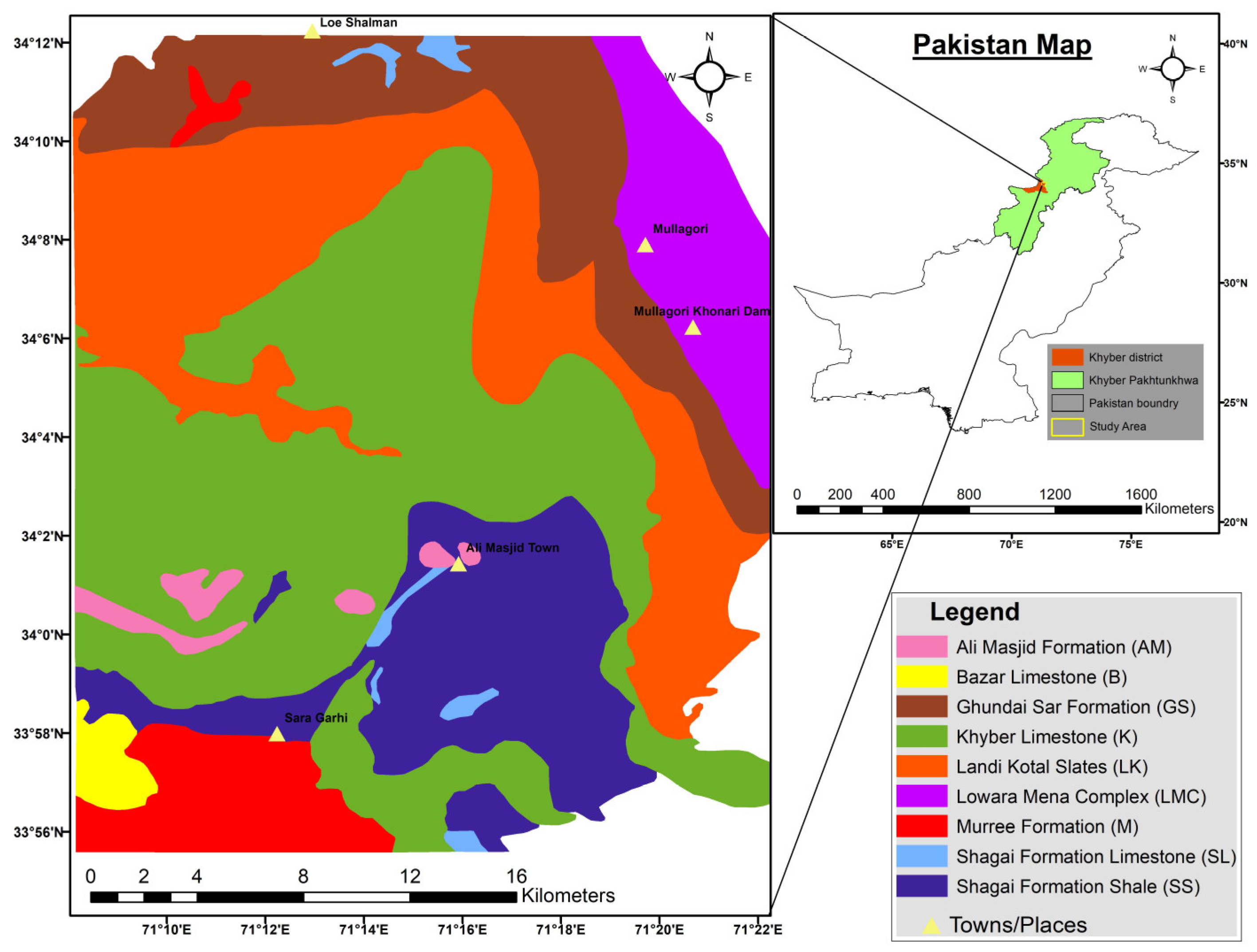
2.1. Study Area
2.2. Geological and Tectonic Framework
2.3. Stratigraphic Setup of Khyber Area
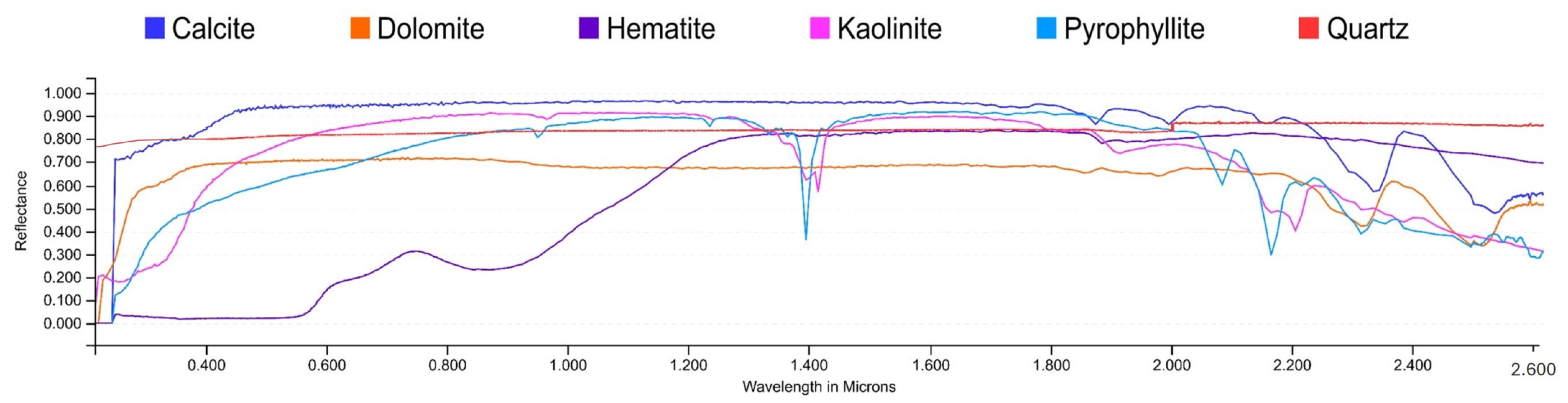
2.4. Mineral Potential
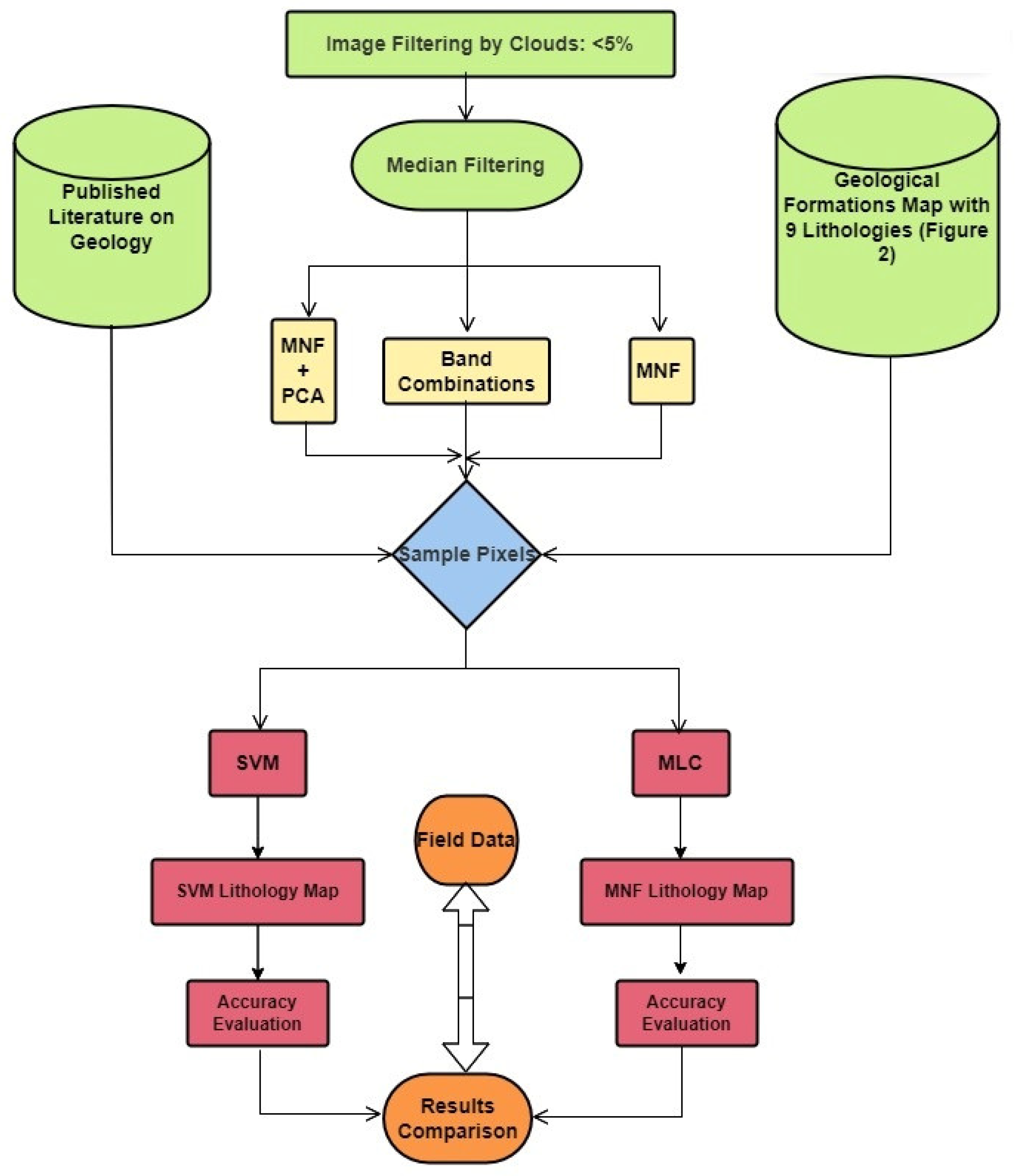
3. Materials and Methods
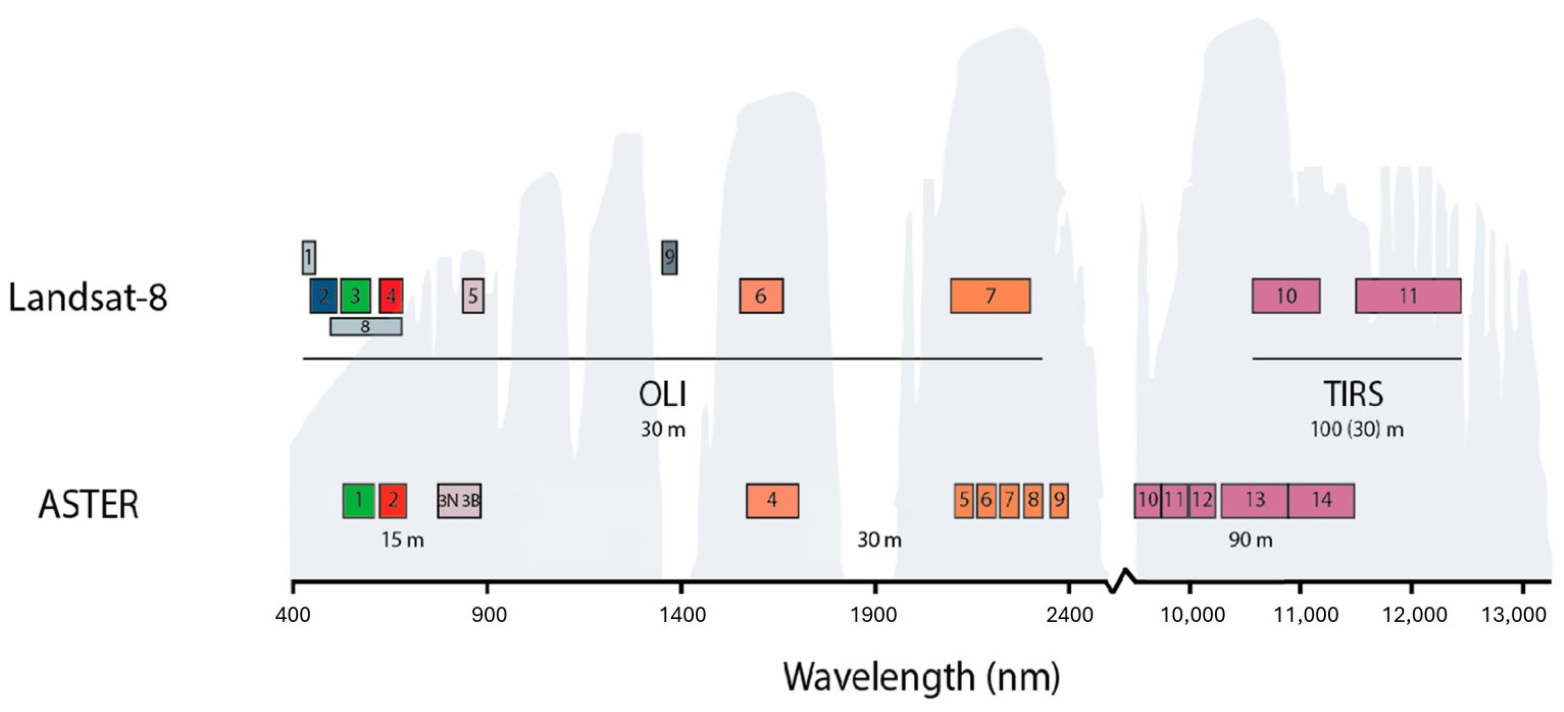
3.1. Datasets
3.2. Data Preprocessing
3.3. Minimum Noise Fraction (MNF)
3.4. Principal Component Analysis (PCA)
3.5. ASTER and OLI Band Combinations
3.6. Spectral Band Ratioing
3.7. Machine Learning and Deep Learning-Based Techniques
3.7.1. Training and Testing Samples
3.7.2. Supervised Classification Algorithms
3.7.3. Maximum Likelihood Classifier
3.7.4. Support Vector Machine (SVM)
3.7.5. Accuracy Measures
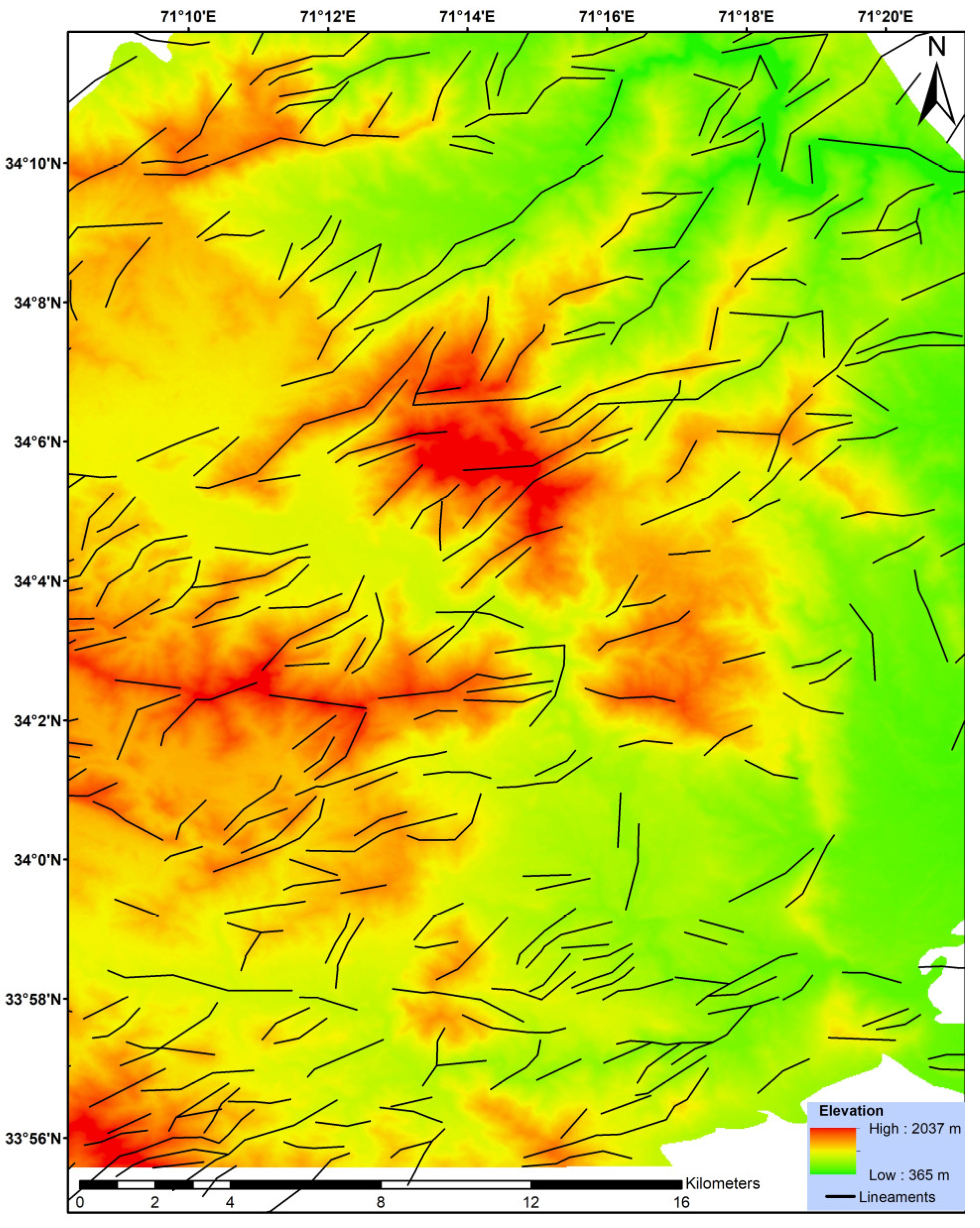
3.8. Lineament Mapping
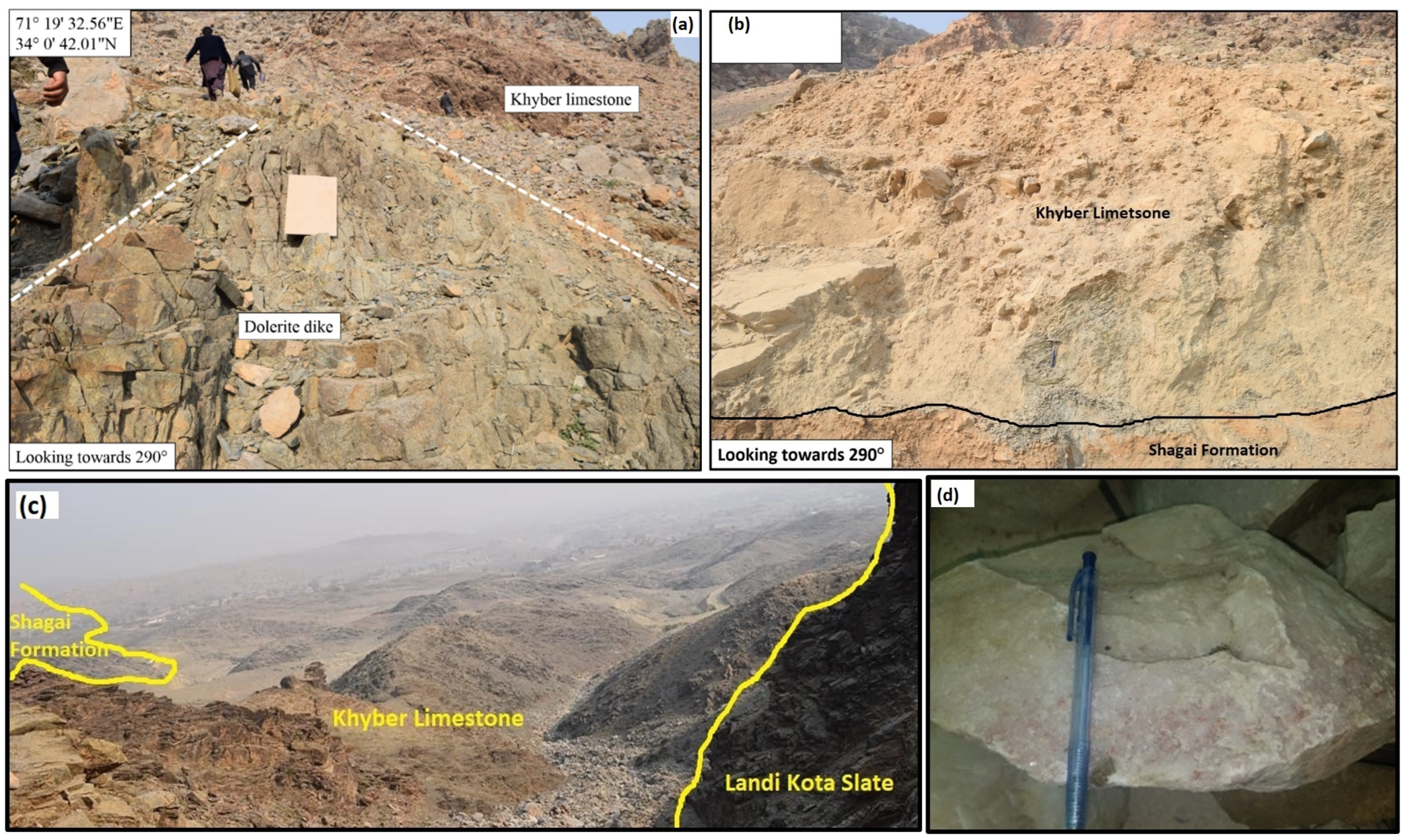
3.9. Field Data Validation
4. Results
4.1. Minimum Noise Fraction (MNF) Transformation
4.2. Principal Component Analysis (PCA)
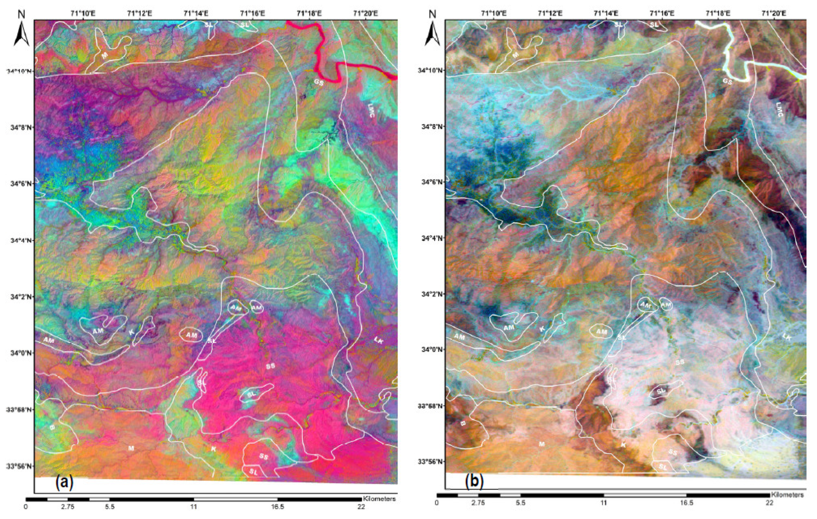
4.3. Color Composite
4.4. Band Ratios
4.5. SVM and MLC Classification Results
5. Discussion
5.1. Principal Component Analysis (PCA)
5.2. Color Composites
5.3. Band Ratios
5.4. Machine Learning Algorithms (MLAs)
5.5. MLA Classification Accuracy
5.6. Discriminating Capability of ASTER and OLI
5.7. Comparison with Existing Maps
6. Conclusions
- (1)
- ASTER has better results than OLI for using remote sensing and MLC and SVM machine learning techniques for the lithological discrimination of the Khyber range.
- (2)
- In semi-arid and dry regions like the Khyber range, SVM outperforms MLC in lithological classification.
Author Contributions
Funding
Institutional Review Board Statement
Informed Consent Statement
Data Availability Statement
Conflicts of Interest
References
- Bachri, I.; Hakdaoui, M.; Raji, M.; Teodoro, A.C.; Benbouziane, A.; Cl, A. Machine Learning Algorithms for Automatic Lithological Mapping Using Remote Sensing Data: A Case Study from Souk Arbaa Sahel, Sidi Ifni Inlier, Western Anti-Atlas, Morocco. ISPRS Int. J. Geo-Inf. 2019, 8, 248. [Google Scholar] [CrossRef]
- Hamimi, Z.; Hagag, W.; Kamh, S.; El-Araby, A.M.A. Application of remote-sensing techniques in geological and structural mapping of Atalla Shear Zone and Environs, Central Eastern Desert, Egypt. Arab. J. Geosci. 2020, 13, 414. [Google Scholar] [CrossRef]
- Khan, M.F.A.; Muhammad, K.; Bashir, S.; Ud Din, S.; Hanif, M. Mapping Allochemical Limestone Formations in Hazara, Pakistan Using Google Cloud Architecture: Application of Machine-Learning Algorithms on Multispectral Data. ISPRS Int. J. Geo-Inf. 2021, 10, 58. [Google Scholar] [CrossRef]
- Köhler, M.; Hanelli, D.; Schaefer, S.; Barth, A.; Knobloch, A.; Hielscher, P.; Cardoso-Fernandes, J.; Lima, A.; Teodoro, A.C. Lithium potential mapping using artificial neural networks: A case study from central portugal. Minerals 2021, 11, 1046. [Google Scholar] [CrossRef]
- Merembayev, T.; Kurmangaliyev, D.; Bekbauov, B.; Amanbek, Y. A Comparison of Machine Learning Algorithms in Predicting Lithofacies: Case Studies from Norway and Kazakhstan. Energies 2021, 14, 1896. [Google Scholar] [CrossRef]
- Öztan, N.S.; Süzen, M.L. Mapping evaporate minerals by ASTER. Int. J. Remote Sens. 2011, 32, 1651–1673. [Google Scholar] [CrossRef]
- Sekandari, M.; Aminpour, S.M.; Masoumi, I.; Pour, A.B.; Muslim, A.M.; Rahmani, O.; Hashim, M.; Zoheir, B.; Pradhan, B.; Misra, A. Application of Landsat-8, Sentinel-2, ASTER and WorldView-3 Spectral Imagery for Exploration of Carbonate-Hosted Pb-Zn Deposits in the Central Iranian Terrane (CIT). Remote Sens. 2020, 12, 1239. [Google Scholar] [CrossRef]
- Zhang, X.; Li, P. Lithological mapping from hyperspectral data by improved use of spectral angle mapper. Int. J. Appl. Earth Obs. Geoinf. 2014, 31, 95–109. [Google Scholar] [CrossRef]
- Masoumi, F.; Eslamkish, T.; Honarmand, M.; Abkar, A.A. A comparative study of Landsat-7 and Landsat-8 data using image processing methods for hydrothermal alteration mapping. Resour. Geol. 2017, 67, 72–88. [Google Scholar] [CrossRef]
- Gad, S.; Kusky, T. Lithological mapping in the eastern desert of Egypt, the barramiya area, using Landsat Thematic Mapper (TM). J. Afr. Earth Sci. 2006, 44, 196–202. [Google Scholar] [CrossRef]
- Gad, S.; Kusky, T. ASTER spectral ratioing for lithological mapping in the Arabian–Nubian shield, the Neoproterozoic wadi kid area, Sinai, Egypt. Gondwana Res. 2007, 11, 326–335. [Google Scholar] [CrossRef]
- Gupta, R.P. Spectra of Minerals and Rocks. In Remote Sensing Geology; Springer: Berlin/Heidelberg, Germany, 2003; pp. 33–52. ISBN 978-3-662-05283-9. [Google Scholar]
- Van der Meer, F.D.; van der Werff, H.M.A.; van Ruitenbeek, F.J.A. Potential of ESA’s Sentinel-2 for geological applications. Remote Sens. Environ. 2014, 148, 124–133. [Google Scholar] [CrossRef]
- Van der Meer, F.D.; van der Werff, H.M.A.; van Ruitenbeek, F.J.A.; Hecker, C.A.; Bakker, W.H.; Noomen, M.F.; van der Meijde, M.; Carranza, E.J.M.; de Smeth, J.B.; Woldai, T.; et al. Multi- and hyperspectral geologic remote sensing: A review. Int. J. Appl. Earth Obs. Geoinf. 2012, 14, 112–128. [Google Scholar] [CrossRef]
- Yamaguchi, Y.; Kahle, A.B.; Tsu, H.; Kawakami, T.; Pniel, M. Overview of advanced spaceborne thermal emission and reflection radiometer (ASTER). IEEE Trans. Geosci. Remote Sens. 1998, 36, 1062–1071. [Google Scholar] [CrossRef]
- Mshiu, E.E. Landsat remote sensing data as an alternative approach for geological mapping in Tanzania: A case study in the Rungwe volcanic province, South-Western Tanzania. Tanz. J. Sci. 2011, 37, 26–36. [Google Scholar]
- Hewson, R.D.; Cudahy, T.J.; Mizuhiko, S.; Ueda, K.; Mauger, A.J. Seamless geological map generation using ASTER in the Broken Hill-Curnamona province of Australia. Remote Sens. Environ. 2005, 99, 159–172. [Google Scholar] [CrossRef]
- Graettinger, A.H.; Ellis, M.K.; Skilling, I.P.; Reath, K.; Ramsey, M.S.; Lee, R.J.; Hughes, C.G.; McGarvie, D.W. Remote sensing and geologic mapping of glaciovolcanic deposits in the region surrounding Askja (Dyngjufjöll) volcano, Iceland. Int. J. Remote Sens. 2013, 34, 7178–7198. [Google Scholar] [CrossRef]
- Asl, R.A.; Afzal, P.; Adib, A.; Yasrebi, A.B. Application of multifractal modeling for the identification of alteration zones and major faults based on ETM+ multispectral data. Arab. J. Geosci. 2015, 8, 2997–3006. [Google Scholar] [CrossRef]
- Pournamdari, M.; Hashim, M.; Pour, A.B. Application of ASTER and Landsat TM data for geological mapping of Esfandagheh ophiolite complex, southern Iran. Resour. Geol. 2014, 64, 233–246. [Google Scholar] [CrossRef]
- Masoumi, F.; Eslamkish, T.; Abkar, A.A.; Honarmand, M.; Harris, J.R. Integration of spectral, thermal, and textural features of ASTER data using random forests classification for lithological mapping. J. Afr. Earth Sci. 2017, 129, 445–457. [Google Scholar] [CrossRef]
- Crosta, A.; De Souza Filho, C.; Azevedo, F.; Brodie, C. Targeting key alteration minerals in epithermal deposits in Patagonia, Argentina, using ASTER imagery and principal component analysis. Int. J. Remote Sens. 2003, 24, 4233–4240. [Google Scholar] [CrossRef]
- Rowan, L.C.; Mars, J.C.; Simpson, C.J. Lithologic mapping of the Mordor, NT, Australia ultramafic complex by using the Advanced Spaceborne Thermal Emission and Reflection Radiometer (ASTER). Remote Sens. Environ. 2005, 99, 105–126. [Google Scholar] [CrossRef]
- Tangestani, M.H.; Jaffari, L.; Vincent, R.K.; Sridhar, B.M. Spectral characterization and ASTER-based lithological mapping of an ophiolite complex: A case study from Neyriz ophiolite, SW Iran. Remote Sens. Environ. 2011, 115, 2243–2254. [Google Scholar] [CrossRef]
- Tangestani, M.H.; Shayeganpour, S. Mapping a lithologically complex terrain using Sentinel-2A data: A case study of Suriyan area, southwestern Iran. Int. J. Remote Sens. 2020, 41, 3558–3574. [Google Scholar] [CrossRef]
- El Atillah, A.; El Morjani, Z.E.A.; Souhassou, M. Use of the Sentinel-2A Multispectral Image for Litho-Structural and Alteration Mapping in Al Glo’a Map Sheet (1/50,000) (Bou Azzer-El Graara Inlier, Central Anti-Atlas, Morocco). Artif. Satell. 2019, 54, 73–96. [Google Scholar] [CrossRef]
- Tripathi, M.K. Lithological Mapping using Digital Image Processing Techniques on Landsat 8 OLI Remote Sensing Data in Jahajpur, Bhilwara, Rajasthan. In Proceedings of the 2nd International Conference on Intelligent Communication and Computational Techniques (ICCT), Jaipur, India, 28–29 September 2019; pp. 43–48. [Google Scholar]
- Salehi, S.; Mielke, C.; Brogaard Pedersen, C.; Dalsenni Olsen, S. Comparison of ASTER and sentinel-2 spaceborne datasets for geological mapping: A case study from North-East Greenland. Geol. Surv. Denmark Greenl. Bull. 2019, 43, e2019430205. [Google Scholar] [CrossRef]
- Chollet, F. Deep Learning with Python, 1st ed.; Manning Publications Co.: Shelter Island, NY, USA, 2017; ISBN 1617294438. [Google Scholar]
- Othman, A.A.; Gloaguen, R. Integration of spectral, spatial and morphometric data into lithological mapping: A comparison of different Machine Learning Algorithms in the Kurdistan Region, NE Iraq. J. Asian Earth Sci. 2017, 146, 90–102. [Google Scholar] [CrossRef]
- Kabolizadeh, M.; Rangzan, K.; Mousavi, S.S.; Azhdari, E. Applying optimum fusion method to improve lithological mapping of sedimentary rocks using sentinel-2 and ASTER satellite images. Earth Sci. Inform. 2022, 15, 1765–1778. [Google Scholar] [CrossRef]
- Janati, M.H.; Soulaimani, A.; Admou, H.; Youbi, N.; Hafid, A.; Hefferan, K.P. Application of ASTER remote sensing data to geological mapping of basement domains in arid regions: A case study from the Central Anti-Atlas, Iguerda inlier, Morocco. Arab. J. Geosci. 2013, 7, 2407–2422. [Google Scholar] [CrossRef]
- Fal, S.; Maanan, M.; Baidder, L.; Rhinane, H. The contribution of Sentinel-2 satellite images for geological mapping in the south of Tafilalet basin (Eastern Anti-Atlas, Morocco). In Proceedings of the 5th International Conference on Geoinformation Science—GeoAdvances, Casablanca, Morocco, 10–11 October 2018; The International Archives of the Photogrammetry, Remote Sensing and Spatial Information Sciences: Casablanca, Morrocco, 2019; Volume XLII-4/W12, pp. 75–82. [Google Scholar]
- Cheng, G.; Zhang, H.; Li, H.; Deng, X.; Elatikpo, S.M.; Li, J.; Hu, Z.; Li, G. Quantitative inversion of REEs in ion-adsorbed rare earth ores from the Liutang area (South China), based on measured hyperspectral data. J. Earth Sci. 2023, 34, 1068–1082. [Google Scholar] [CrossRef]
- Li, S.; Song, W.; Fang, L.; Chen, Y.; Ghamisi, P.; Benediktsson, J.A. Deep Learning for Hyperspectral Image Classification: An Overview. IEEE Trans. Geosci. Remote Sens. 2019, 57, 6690–6709. [Google Scholar] [CrossRef]
- Yokoya, N.; Chan, J.; Segl, K. Potential of resolution-enhanced hyperspectral data for mineral mapping using simulated EnMAP and Sentinel-2 images. Remote Sens. 2016, 8, 172. [Google Scholar] [CrossRef]
- USGS Spectral Characteristic Viewer. Available online: https://landsat.usgs.gov/spectral-characteristics-viewer (accessed on 20 February 2024).
- Shah, M.M.; Afridi, S.; Khan, E.U.; Rahim, H.U.; Mustafa, M.R. Diagenetic modifications and reservoir heterogeneity associated with magmatic intrusions in the Devonian Khyber Limestone, Peshawar Basin, NW Pakistan. Geofluids 2021, 2021, 8816465. [Google Scholar] [CrossRef]
- Treloar, P.J.; Broughten, R.D.; Coward, M.P.; Williams, M.P.; Windley, B.F. Deformation, Metamorphism and Imbrication of the Indian Plate South of MMT, North Pakistan. J. Metamorph. Geol. 1989, 7, 111–127. [Google Scholar] [CrossRef]
- Kazmi, A.H.; Jan, M.Q. Geology and Tectonics of Pakistan; Graphic Publishers: Karachi, Pakistan, 1997. [Google Scholar]
- Tahirkheli, R.K.; Mattauer, M.; Proust, F.; Tapponnier, P. The India-Eurasia suture zone in northern Pakistan: Synthesis and interpretation of recent data at plate scale. In Geodynamics of Pakistan; Farah, A., Jong, K.A., Eds.; Geological Survey of Pakistan: Quetta, Pakistan, 1979; pp. 125–130. [Google Scholar]
- DiPietro, J.A.; Pogue, K.R. Tectonostratigraphic Subdivisions of the Himalaya: A View from the West. Tectonics 2004, 23, TC5001. [Google Scholar] [CrossRef]
- Zhu, D.; Meng, Q.; Jin, Z.; Liu, Q.; Hu, W. Formation mechanism of deep Cambrian dolomite reservoirs in the Tarim basin, northwestern China. Mar. Pet. Geol. 2015, 59, 232–244. [Google Scholar] [CrossRef]
- Calkin, J.A.; Offield, T.W.; Abdullah, S.K.; Ali, S.T. Geology of the Southern Himalaya in Hazara, Pakistan, and Adjacent Areas; U.S. Geological Survey Professional Paper 716-C; United States Government Printing Office: Washington, DC, USA, 1975. [Google Scholar]
- Shah, S.M.I.; Siddiqui, R.A.; Talent, J.A. Geology of the Eastern Khyber Agency, North Western Frontier Province, Pakistan; Geological Survey of Pakistan: Quetta, Pakistan, 1980; Volume 44. [Google Scholar]
- Ali, A.; Ali, S.; Akbar, S.; Azad, A.; Danish, A.; Ahmad, R.; Ali, L. Lead Mineralization in Carbonate Rocks Jamrud, District Khyber, Pakistan. In Proceedings of the International Conference on Mediterranean Geosciences Union, Istanbul, Turkey, 25–28 November 2021; Springer Nature: Cham, Switzerland, 2021; pp. 117–122. [Google Scholar]
- Fujisada, H.; Iwasaki, A.; Hara, S. In ASTER stereo system performance. Proc. SPIE 2001, 4540, 39–49. [Google Scholar]
- Duda, K.; Daucsavage, J.; Siemonsma, D.; Brooks, B.; Oleson, R.; Meyer, D.; Doescher, C. Advanced Spaceborne Thermal Emission and Reflection Radiometer (ASTER) Level 1 Precision Terrain Corrected Registered At-Sensor Radiance Product (AST_L1T): AST_L1T Product User’s Guide, Version 1.1; USGS: Reston, VA, USA, 2020. [Google Scholar]
- United States Geological Survey (USGS). Landsat 8 Band Designations. Available online: https://www.usgs.gov/media/images/landsat-8-band-designations (accessed on 16 January 2020).
- USGS Landsat Program. Comparison of #Landsat 7, 8, #Sentinel 2, #ASTER & #MODIS Bands. View Band Designations for All #Landsat Sensors. Available online: https://twitter.com/usgslandsat/status/837696716417687553 (accessed on 22 December 2017).
- Crosta, A.P.; Rabelo, A. Assessing Landsat TM for hydrothermal alteration mapping in central-western Brazil. In Proceedings of the 9th Thematic Conference on Geologic Remote Sensing, Pasadena, CA, USA, 8–11 February 1993; Environmental Research Institute of Michigan: Pasadena, CA, USA, 1993; pp. 1053–1061. [Google Scholar]
- Hastie, T.; Tibshirani, R.; Friedman, J. The Elements of Statistical Learning: Data Mining, Inference, and Prediction, 2nd ed.; Springer Series in Statistics; Springer: New York, NY, USA, 2009; ISBN 9780387848587. [Google Scholar]
- Crowley, J.K.; Brickey, D.W.; Rowan, L.C. Airborne imaging spectrometer data of the Ruby Mountains, Montana: Mineral discrimination using relative absorption band-depth images. Remote Sens. Environ. 1989, 29, 121–134. [Google Scholar] [CrossRef]
- Sabins, F.F. Remote sensing for mineral exploration. Ore Geol. Rev. 1999, 14, 157–183. [Google Scholar] [CrossRef]
- Son, Y.S.; Kim, K.E.; Yoon, W.J.; Cho, S.J. Regional mineral mapping of island arc terranes in southeastern Mongolia using multispectral remote sensing data. Ore Geol. Rev. 2019, 113, 103106. [Google Scholar] [CrossRef]
- Son, Y.S.; You, B.W.; Bang, E.S.; Cho, S.J.; Kim, K.E.; Baik, H.; Nam, H.T. Mapping alteration mineralogy in eastern Tsogttsetsii, Mongolia, based on the WorldView-3 and field shortwave-infrared spectroscopy analyses. Remote Sens. 2021, 13, 914. [Google Scholar] [CrossRef]
- Shibata, Y. Application of ASTER Data to Mineral Exploration for Cyprus-Type Massive Sulphide Deposits of Oman Ophiolite. In ASTER Science Project Report; NASA: Washington, DC, USA, 2002. [Google Scholar]
- Smith, R.B. Hyperspectral Imaging. Getting Started with TNT Mips Software; Microimages PLC: Lincoln, NE, USA, 2001. [Google Scholar]
- Ninomiya, Y.; Fu, B.; Cudahy, T.J. Detecting lithology with Advanced Spaceborne Thermal Emission and Reflection Radiometer (ASTER) multispectral thermal infrared “radiance-at-sensor” data. Remote Sens. Environ. 2002, 84, 127–139. [Google Scholar] [CrossRef]
- Rowan, L.C.; Kahle, A.B. Evaluation of 0.46 to 2.36 µm Multispectral Scanner images of the East Tintic Mining District, Utah, for mapping hydrothermally altered rocks. Econ. Geol. J. 1982, 77, 441–452. [Google Scholar] [CrossRef]
- Mather, P.M. Computer Processing of Remotely Sensed Images. An Introduction; John Wiley & Sons, Ltd.: Hoboken, NJ, USA, 2001. [Google Scholar]
- Meng, Z.; Li, L.; Jiao, L.; Feng, Z.; Tang, X.; Liang, M. Fully Dense Multiscale Fusion Network for Hyperspectral Image Classification. Remote Sens. 2019, 11, 2718. [Google Scholar] [CrossRef]
- Tran, D.; Bourdev, L.; Fergus, R.; Torresani, L.; Paluri, M. Learning spatiotemporal features with 3d convolutional networks. In Proceedings of the IEEE International Conference on Computer Vision, Santiago, Chile, 13–16 December 2015; pp. 4489–4497. [Google Scholar]
- Zhou, B.; Lapedriza, A.; Xiao, J.; Torralba, A.; Oliva, A. Learning deep features for scene recognition using places database. In Advances in Neural Information Processing Systems 27 (NIPS 2014), Proceedings of the Annual Conference on Neural Information Processing Systems 2014, Montreal, QC, Canada, 8–13 December 2014; MIT Press: Cambridge, MA, USA, 2014; pp. 487–495. [Google Scholar]
- Chen, Y.; Wu, W.; Zhao, Q. A Bat-Optimized One-Class Support Vector Machine for Mineral Prospectivity Mapping. Minerals 2019, 9, 317. [Google Scholar] [CrossRef]
- Gislason, P.O.; Benediktsson, J.A.; Sveinsson, J.R. Random forests for land cover classification. Pattern Recognit. Lett. 2006, 27, 294–300. [Google Scholar] [CrossRef]
- Rodriguez-Galiano, V.F.; Ghimire, B.; Rogan, J.; Chica-Olmo, M.; Rigol-Sanchez, J.P. An assessment of the effectiveness of a random forest classifier for land-cover classification. ISPRS J. Photogramm. Remote Sens. 2012, 67, 93–104. [Google Scholar] [CrossRef]
- Othman, A.; Gloaguen, R. Improving lithological mapping by SVM classification of spectral and morphological features: The discovery of a new chromite body in the Mawat ophiolite complex (Kurdistan, NE Iraq). Remote Sens. 2014, 6, 6867–6896. [Google Scholar] [CrossRef]
- Jaakkola, T.; Haussler, D. Exploiting generative models in discriminative classifiers. In Advances in Neural Information Processing Systems 11 (NIPS 1998), Proceedings of the Annual Conference on Neural Information Processing Systems 1998, Denver, CO, USA, 1–3 December 1998; MIT Press: Cambridge, MA, USA, 1998; pp. 487–493. [Google Scholar]
- Melgani, F.; Bruzzone, L. Classification of hyperspectral remote sensing images with support vector machines. IEEE Trans. Geosci. Remote Sens. 2004, 42, 1778–1790. [Google Scholar] [CrossRef]
- Li, N.; Huang, X.; Zhao, H.; Qiu, X.; Deng, K.; Jia, G.; Gong, X. A Combined Quantitative Evaluation Model for the Capability of Hyperspectral Imagery for Mineral Mapping. Sensors 2019, 19, 328. [Google Scholar] [CrossRef]
- Clark, R.N. Chapter 1–8: Spectroscopy of Rocks and Minerals, and Principles of Spectroscopy. In Manual of Remote Sensing, Remote Sensing for the Earth Sciences; John Wiley and Sons: New York, NY, USA, 1999; Volume 3, pp. 3–58. [Google Scholar]
- Rowan, L.C.; Mars, J.C. Lithologic mapping in the Mountain Pass, California area using Advanced Spaceborne Thermal Emission and Reflection Radiometer (ASTER) data. Remote Sens. Environ. 2003, 84, 350–366. [Google Scholar] [CrossRef]
- Nasir, S.; Rajendran, S. ASTER Spectral Sensitivity of carbonate rocks—Study in Sultanate of Oman. Adv. Sp. Res. 2014, 53, 656–673. [Google Scholar]
- Chen, X.; Warner, T.A.; Campagna, D.J. Integrating visible, near infrared and short-wave infrared hyperspectral and multispectral thermal imagery for geological mapping at Cuprite, Nevada. Remote Sens. Environ. 2007, 110, 344–356. [Google Scholar] [CrossRef]
- Mondal, A.; Kundu, S.; Chandniha, S.K.; Shukla, R.; Mishra, P. Comparison of support vector machine and maximum likelihood classification technique using satellite imagery. Int. J. Remote Sens. GIS 2012, 1, 116–123. [Google Scholar]
- Zhang, X.; Pazner, M.; Duke, N. Lithologic and mineral information extraction for gold exploration using ASTER data in the south chocolate mountains (California). ISPRS J. Photogramm. Remote Sens. 2007, 62, 271–282. [Google Scholar]
- Scott, A.J.; Symons, M.J. Clustering methods based on likelihood ratio criteria. Biometrics 1971, 27, 387–397. [Google Scholar] [CrossRef]
- Cracknell, M.J.; Reading, A.M. Geological mapping using remote sensing data: A comparison of five machine learning algorithms, their response to variations in the spatial distribution of training data and the use of explicit spatial information. Comput. Geosci. 2014, 63, 22–33. [Google Scholar] [CrossRef]
- Din, S.U.; Muhammad, K.; Khan, M.F.A.; Bashir, S.; Sajid, M.; Khan, A. A fusion of feature-oriented principal components of multispectral data to map granite exposures of Pakistan. Appl. Sci. 2021, 11, 11486. [Google Scholar] [CrossRef]
- Vapnik, V. The support vector method of function estimation. In Nonlinear Modeling; Suykens, J.A.K., Vandewalle, J., Eds.; Springer: Boston, MA, USA, 1998; pp. 55–85. [Google Scholar]
- Hsu, C.W.; Chang, C.C.; Lin, C.J. A Practical Guide to Support Vector Classification; Department of Computer Science, National Taiwan University, Taipei 106: Taiwan, China, 2010; pp. 1–16. [Google Scholar]
- Gu, J.; Wang, L.; Wang, H.; Wang, S. A novel approach to intrusion detection using SVM ensemble with feature augmentation. Comput. Secur. 2019, 86, 53–62. [Google Scholar] [CrossRef]
- Story, M.; Congalton, R.G. Accuracy Assessment: A User’s Perspective. Photogramm. Eng. Remote Sens. 1986, 52, 397–399. [Google Scholar]
- Brown, D.G.; Lusch, D.P.; Duda, K.A. Supervised classification of types of glaciated landscapes using digital elevation data. Geomorphology 1998, 21, 233–250. [Google Scholar] [CrossRef]
- Moradpour, H.; Rostami Paydar, G.; Pour, A.B.; Valizadeh Kamran, K.; Feizizadeh, B.; Muslim, A.M.; Hossain, M.S. Landsat-7 and ASTER remote sensing satellite imagery for identification of iron skarn mineralization in metamorphic regions. Geocarto Int. 2022, 37, 1971–1998. [Google Scholar] [CrossRef]
- Jensen, J.R. Introductory Digital Image Processing; Person Prentice Hall: Upper Saddle River, NJ, USA, 2005. [Google Scholar]
- Rasouli Beirami, M.; Tangestani, M.H. A new band ratio approach for discriminating calcite and dolomite by ASTER imagery in arid and semiarid regions. Nat. Resour. Res. 2020, 29, 2949–2965. [Google Scholar] [CrossRef]
- Rockwell Barnaby, W.; Hofstra, A.H. Identification of quartz and carbonate minerals across northern Nevada using ASTER thermal infrared emissivity data—Implications for geologic mapping and mineral resource investigations in well-studied and frontier areas. Geosphere 2008, 4, 218–246. [Google Scholar] [CrossRef]
- Nemmour-Zekiri, D.; Oulebsir, F. Application of remote sensing techniques in lithologic mapping of Djanet Region, Eastern Hoggar Shield, Algeria. Arab. J. Geosci. 2020, 13, 632. [Google Scholar] [CrossRef]
- Rajendran, S.; Nasir, S. Mapping of manganese potential areas using ASTER satellite data in parts of Sultanate of Oman. Int. J. Geosci. 2013, 1, 92–101. [Google Scholar]
- Rajendran, S.; Nasir, S. Mapping of hydrothermal alteration in the upper mantle-lower crust transition zone of the Tayin Massif, Sultanate of Oman using remote sensing technique. J. Afr. Earth Sci. 2019, 150, 722–743. [Google Scholar] [CrossRef]
- Rajendran, S.; Nasir, S. ASTER capability in mapping of mineral resources of arid region: A review on mapping of mineral resources of the Sultanate of Oman. Ore Geol. Rev. 2019, 108, 33–53. [Google Scholar] [CrossRef]
- Xi, Y.; Mohamed Taha, A.M.; Hu, A.; Liu, X. Accuracy comparison of various remote sensing data in lithological classification based on random forest algorithm. Geocarto Int. 2022, 37, 14451–14479. [Google Scholar] [CrossRef]
- Kruse, F.A. Geologic mapping using combined analysis of Airborne Visible/Infrared Imaging Spectrometer (AVIRIS) and SIR-C/X-SAR data. Imaging Spectrom. II 1996, 2819, 24–35. [Google Scholar]
- Mansour, S.A.; Guangdao, H. Using remote sensing data to improve geological interpretation mapping in Heqing Area, Northwestern Yunnan Province. China. J. Inf. Technol. 2007, 6, 495–501. [Google Scholar]
- Khan, S.D.; Mahmood, K.; Casey, J.F. Mapping of Muslim Bagh ophiolite complex (Pakistan) using new remote sensing, and field data. J. Asian Earth Sci. 2007, 30, 333–343. [Google Scholar] [CrossRef]
- Rajesh, H.M. Mapping Proterozoic unconformity-related uranium deposits in the Rockhole area, Northern Territory, Australia using landsat ETM+. Ore Geol. Rev. 2008, 33, 382–396. [Google Scholar] [CrossRef]
- Van der Werff, H.M.A.; Van der Meer, F.D. Shape-based classification of spectrally identical objects. ISPRS J. Photogramm. Remote Sens. 2008, 63, 251–258. [Google Scholar] [CrossRef]
- Bishta, A.Z. Lithologic discrimination using selective image processing technique of Landsat 7 data, Um Bogma Environs Westcentral Sinai, Egypt. Earth Sci. 2009, 20, 193–213. [Google Scholar] [CrossRef]
- Bishta, A.Z. Assessing utilization of multi-resolution satellite imageries in geological mapping, a case study of Jabal Bani Malik area, eastern Jeddah city, Kingdom of Saudi Arabia. JKAU Earth Sci. 2010, 21, 27–52. [Google Scholar] [CrossRef]
- Bajwa, R.S.; Ahsan, N.; Ahmad, S.R. A review of Landsat false color composite images for lithological mapping of pre-Cambrian to recent rocks: A case study of Pail/Padhrar Area in Punjab Province, Pakistan. J. Indian Soc. Remote Sens. 2020, 48, 721–728. [Google Scholar] [CrossRef]
- Cohen, J. A coefficient of agreement for nominal scales. Educ. Psychol. Meas. 1960, 20, 37–46. [Google Scholar] [CrossRef]
- Yu, L.; Porwal, A.; Holden, E.J.; Dentith, M.C. Towards automatic lithological classification from remote sensing data using support vector machines. Comput. Geosci. 2012, 45, 229–239. [Google Scholar] [CrossRef]
- Rowan, L.C.; Mars, J.C.; Simpson, C.J. Discrimination of hydrothermally altered and unaltered rocks in visible and near infrared multispectral images. Geophysics 1977, 42, 522–535. [Google Scholar] [CrossRef]
- Podwysocki, M.H.; Segal, D.B.; Abrams, M.J. Use of selective absorption bands for lithologic mapping of silicate rocks by remote sensing. J. Geophys. Res. Solid Earth 1984, 89, 6329–6340. [Google Scholar]
- Sultan, M.; Sturchio, N.; Hassan, F.A.; Hamdan, M.A.; Mahmood, A.M.; Alfy, Z.E.; Stein, T. Mapping of gold mineralization in the Eastern Desert of Egypt using Landsat thematic mapper data. Geology 1987, 15, 1022–1025. [Google Scholar] [CrossRef]
- Knepper, D.H., Jr.; Simpson, S.L. Remote sensing and geologic mapping of hydrothermal alteration in the Colorado Mineral Belt. In Proceedings of the Thirteenth Annual ESRI User Conference; Environmental Systems Research Institute: Redlands, CA, USA, 1992. [Google Scholar]
- Spatz, D.M.; Wilson, S.A. Remote sensing for environmental site assessment: A case study in hydrothermal alteration zone mapping. Photogramm. Eng. Remote Sens. 1994, 60, 1011–1017. [Google Scholar]
- Sabine, C. Remote sensing strategies for mineral exploration. In Proceedings of the Exploration 97: Fourth Decennial International Conference on Mineral Exploration, Toronto, ON, Canada, 14–18 September 1997; pp. 877–892. [Google Scholar]
- Perry, S.L. Spaceborneand airborne remote sensing systems for mineral exploration-case histories using infrared spectroscopy. In Infrared Spectroscopy in Geochemistry, Exploration Geochemistry, and Remote Sensing; King, P.L., Ramsey, M.S., Swayze, G.A., Eds.; Mineralogic Association of Canada: London, ON, Canada, 2004; pp. 227–240. [Google Scholar]
- Mars, J.C.; Rowan, L.C. Spectral assessment of new ASTER SWIR surface reflectance data products for spectroscopic mapping of rocks and minerals. Remote Sens. Environ. 2010, 114, 2011–2025. [Google Scholar] [CrossRef]
- Özkan, M.; Çelik, Ö.F.; Özyavaş, A. Lithological discrimination of accretionary complex (Sivas, northern Turkey) using novel hybrid color composites and field data. J. Afr. Earth Sci. 2018, 138, 75–85. [Google Scholar] [CrossRef]
- Rezaei, A.; Hassani, H.; Moarefvand, P.; Golmohammadi, A. Lithological mapping in Sangan region in Northeast Iran using ASTER satellite data and image processing methods. Geol. Ecol. Landsc. 2020, 4, 59–70. [Google Scholar] [CrossRef]
- Muhammad, N.; Muhammad, H.; Saleem, U.; Muhammad, S. Evaluating ASTER data and field spectrometry for lithological discrimination in semi-arid region, Northeast Kohat Plateau, Pakistan. Environ. Earth Sci. 2024, 83, 254. [Google Scholar]
- Phani, P.R.C.; Jayaram, T.; Jayalakshmi, G. An analysis of lineaments and mineral occurrences of Veligallu Schist Belt and surroundings, Eastern Dharwar Craton, India using Remote Sensing & GIS. J. Multidiscip. Eng. Sci. Technol. 2014, 1, 198–204. [Google Scholar]
- Gupta, R.P. Remote Sensing Geology, 3rd ed.; Springer: Berlin/Heidelberg, Germany, 2017; pp. 180–190. [Google Scholar]
- Ahmed, W.; Muhammad, K.; Glass, H.J.; Chatterjee, S.; Khan, A.; Hussain, A. Novel MLR-RF-Based Geospatial Techniques: A Comparison with OK. ISPRS Int. J. Geo-Inf. 2022, 11, 371. [Google Scholar] [CrossRef]
- Hushko, S.; Botelho, J.M.; Maksymova, I.; Slusarenko, K.; Kulishov, V. Sustainable development of global mineral resources market in Industry 4.0 context. In Proceedings of the IOP Conference Series: Earth and Environmental Science, 8th International Scientific Conference on Sustainability in Energy and Environmental Science, Ivano-Frankivsk, Ukraine, 21–22 October 2020; Volume 628, p. 012025. [Google Scholar]
- Jimenez, J.R.C.; Zhao, P.; Mansourian, A.; Brovelli, M.A. Geospatial Blockchain: Review of decentralized geospatial data sharing systems. Agil. GIScience Ser. 2022, 3, 1–6. [Google Scholar] [CrossRef]
- Aziz, A.; Schelén, O.; Bodin, U. A Study on Industrial IoT for the Mining Industry: Synthesized Architecture and Open Research Directions. IoT 2020, 1, 529–550. [Google Scholar] [CrossRef]
- Liu, Y.; Dhakal, S. Internet of Things technology in mineral remote sensing monitoring. Int. J. Circuit Theory Appl. 2020, 48, 2065–2077. [Google Scholar] [CrossRef]
- Molaei, F.; Rahimi, E.; Siavoshi, H.; Afrouz, S.G.; Tenorio, V. A Comprehensive Review on Internet of Things (IoT) and its Implications in the Mining Industry. Am. J. Eng. Appl. Sci. 2020, 13, 499–515. [Google Scholar] [CrossRef]
- Rajesh, H.M. Application of remote sensing and GIS in mineral resource mapping—An overview. J. Miner. Petrol. Sci. 2004, 99, 83–103. [Google Scholar] [CrossRef]


| Formations | M | B | K | SL | SS | AM | LK | GS | LMC | Producer Accuracy (%) | User Accuracy (%) |
|---|---|---|---|---|---|---|---|---|---|---|---|
| Murree Formation (M) | 1195 | 12 | 101 | 0 | 0 | 0 | 0 | 0 | 0 | 88.52 | 80.96 |
| Bazar Limestone (B) | 1 | 54 | 6 | 1 | 2 | 0 | 0 | 0 | 0 | 44.26 | 84.38 |
| Khyber Limestone (K) | 72 | 53 | 1345 | 8 | 133 | 23 | 160 | 45 | 0 | 79.82 | 73.14 |
| Shagai Formation Limestone (SL) | 0 | 0 | 2 | 89 | 21 | 3 | 2 | 0 | 2 | 40.09 | 74.79 |
| Shagai Formation Shale (SS) | 46 | 3 | 95 | 116 | 656 | 48 | 15 | 9 | 18 | 65.73 | 65.21 |
| Ali Masjid Formation (AM) | 0 | 0 | 36 | 0 | 17 | 169 | 5 | 2 | 2 | 62.83 | 73.16 |
| Landi Kotal Slates (LK) | 36 | 0 | 79 | 1 | 5 | 13 | 421 | 69 | 9 | 56.43 | 66.51 |
| Ghundai Sar Formation (GS) | 0 | 0 | 18 | 0 | 29 | 0 | 107 | 813 | 52 | 83.13 | 79.78 |
| Lowara Mena Complex (LMC) | 0 | 0 | 3 | 7 | 3 | 0 | 15 | 38 | 291 | 77.81 | 81.51 |
| Total | 1350 | 122 | 1685 | 222 | 998 | 269 | 746 | 978 | 374 |
| Formations | M | B | K | SL | SS | AM | LK | GS | LMC | Producer Accuracy (%) | User Accuracy (%) |
|---|---|---|---|---|---|---|---|---|---|---|---|
| Murree Formation (M) | 1104 | 0 | 31 | 0 | 79 | 0 | 3 | 0 | 0 | 81.78 | 90.71 |
| Bazar Limestone (B) | 34 | 112 | 20 | 0 | 10 | 0 | 0 | 0 | 0 | 91.8 | 63.64 |
| Khyber Limestone (K) | 26 | 0 | 1149 | 0 | 71 | 0 | 82 | 37 | 0 | 68.19 | 84.18 |
| Shagai Formation Limestone (SL) | 8 | 0 | 5 | 199 | 142 | 0 | 3 | 0 | 0 | 89.64 | 55.74 |
| Shagai Formation Shale (SS) | 49 | 0 | 129 | 16 | 504 | 16 | 9 | 3 | 6 | 50.5 | 68.85 |
| Ali Masjid Formation (AM) | 0 | 0 | 24 | 0 | 69 | 225 | 4 | 0 | 0 | 83.64 | 69.88 |
| Landi Kotal Slates (LK) | 30 | 0 | 121 | 0 | 2 | 4 | 507 | 94 | 6 | 67.96 | 66.36 |
| Ghundai Sar Formation (GS) | 1 | 0 | 35 | 0 | 20 | 0 | 52 | 728 | 4 | 74.44 | 86.67 |
| Lowara Mena Complex (LMC) | 0 | 0 | 2 | 0 | 4 | 0 | 27 | 30 | 326 | 87.17 | 83.8 |
| Total | 1350 | 122 | 1685 | 222 | 998 | 269 | 746 | 978 | 374 |
| Formations | M | B | K | SL | SS | AM | LK | GS | LMC | Producer Accuracy (%) | User Accuracy (%) |
|---|---|---|---|---|---|---|---|---|---|---|---|
| Murree Formation (M) | 302 | 23 | 65 | 3 | 49 | 7 | 3 | 6 | 0 | 73.3 | 65.94 |
| Bazar Limestone (B) | 6 | 23 | 12 | 7 | 0 | 0 | 0 | 1 | 0 | 50 | 46.94 |
| Khyber Limestone (K) | 67 | 0 | 408 | 0 | 42 | 0 | 60 | 12 | 0 | 70.59 | 69.27 |
| Shagai Formation Limestone (SL) | 0 | 0 | 2 | 24 | 13 | 1 | 1 | 1 | 0 | 27.27 | 57.14 |
| Shagai Formation Shale (SS) | 34 | 0 | 30 | 46 | 163 | 48 | 69 | 35 | 6 | 46.18 | 37.82 |
| Ali Masjid Formation (AM) | 0 | 0 | 1 | 0 | 6 | 33 | 2 | 1 | 1 | 33.67 | 75 |
| Landi Kotal Slates (LK) | 3 | 0 | 40 | 0 | 28 | 0 | 90 | 44 | 0 | 35.71 | 43.9 |
| Ghundai Sar Formation (GS) | 0 | 0 | 19 | 8 | 40 | 5 | 26 | 225 | 45 | 62.85 | 61.14 |
| Lowara Mena Complex (LMC) | 0 | 0 | 1 | 0 | 12 | 4 | 1 | 33 | 75 | 59.06 | 59.52 |
| Total | 412 | 46 | 578 | 88 | 353 | 98 | 252 | 358 | 127 |
| Formations | M | B | K | SL | SS | AM | LK | GS | LMC | Producer Accuracy (%) | User Accuracy (%) |
|---|---|---|---|---|---|---|---|---|---|---|---|
| Murree Formation (M) | 273 | 1 | 39 | 0 | 57 | 0 | 3 | 5 | 0 | 66.26 | 72.22 |
| Bazar Limestone (B) | 64 | 45 | 16 | 1 | 0 | 0 | 0 | 0 | 0 | 97.83 | 35.71 |
| Khyber Limestone (K) | 43 | 0 | 361 | 0 | 13 | 0 | 12 | 21 | 0 | 62.46 | 80.22 |
| Shagai Formation Limestone (SL) | 0 | 0 | 5 | 68 | 40 | 12 | 5 | 3 | 7 | 77.27 | 48.57 |
| Shagai Formation Shale (SS) | 15 | 0 | 32 | 3 | 113 | 4 | 18 | 10 | 4 | 32.01 | 56.78 |
| Ali Masjid Formation (AM) | 3 | 0 | 0 | 9 | 40 | 73 | 18 | 6 | 0 | 74.49 | 48.99 |
| Landi Kotal Slates (LK) | 2 | 0 | 83 | 0 | 47 | 1 | 171 | 54 | 0 | 67.86 | 47.77 |
| Ghundai Sar Formation (GS) | 0 | 0 | 13 | 2 | 9 | 3 | 19 | 189 | 1 | 52.79 | 80.08 |
| Lowara Mena Complex (LMC) | 0 | 0 | 0 | 0 | 10 | 0 | 1 | 47 | 92 | 86.79 | 61.33 |
| Total | 412 | 46 | 578 | 88 | 353 | 98 | 252 | 358 | 106 |
| Class | ASTER SVM Total Ground Truth Pixels | ASTER MLC Total Ground Truth Pixels | OLI SVM Total Ground Truth Pixels | OLI MLC Total Ground Truth Pixels |
|---|---|---|---|---|
| Murree Formation (M) | 1476 | 1217 | 458 | 378 |
| Bazar Limestone (B) | 64 | 176 | 49 | 126 |
| Khyber Limestone (K) | 1839 | 1365 | 589 | 450 |
| Shagai Formation Limestone (SL) | 119 | 357 | 42 | 140 |
| Shagai Formation Shale (SS) | 1006 | 732 | 431 | 199 |
| Ali Masjid Formation (AM) | 231 | 322 | 44 | 149 |
| Landi Kotal Slates (LK) | 633 | 764 | 205 | 358 |
| Ghundai Sar Formation (GS) | 1019 | 840 | 368 | 236 |
| Lowara Mena Complex (LMC) | 357 | 389 | 125 | 150 |
| Total | 6744 | 6162 | 2334 | 2186 |
| Eigenvectors | Band 1 | Band 2 | Band 3 | Band 4 | Band 5 | Band 6 | Band 7 | Band 8 | Band 9 | Eigenvalues |
|---|---|---|---|---|---|---|---|---|---|---|
| PC1 | −0.3069 | −0.317 | −0.2935 | −0.3387 | −0.3494 | −0.3491 | −0.3502 | −0.3506 | −0.339 | 0.9813 |
| PC2 | −0.6513 | −0.5828 | 0.0871 | 0.3374 | 0.1866 | 0.2215 | 0.1312 | 0.0706 | 0.0931 | 0.5986 |
| PC3 | −0.0177 | 0.0343 | −0.9214 | −0.0771 | 0.1762 | 0.137 | 0.1927 | 0.198 | 0.1321 | 0.3776 |
| PC4 | 0.1369 | 0.0404 | −0.0732 | 0.3061 | 0.2298 | 0.1811 | 0.1761 | −0.1423 | −0.8624 | 0.1179 |
| PC5 | −0.0149 | −0.2161 | 0.2 | −0.6225 | −0.0066 | −0.0429 | 0.4178 | 0.529 | −0.2632 | 0.0508 |
| PC6 | −0.646 | 0.685 | 0.024 | 0.0601 | −0.114 | −0.1117 | −0.0119 | 0.2484 | −0.1485 | 0.0197 |
| PC7 | −0.201 | 0.1887 | 0.1042 | −0.5265 | 0.463 | 0.4255 | −0.038 | −0.4844 | 0.0661 | 0.0135 |
| PC8 | 0.0149 | 0.0161 | −0.0224 | −0.0294 | −0.6907 | 0.7207 | 0.0271 | −0.0065 | −0.0315 | 0.0105 |
| PC9 | 0.0666 | −0.0726 | 0.0032 | −0.0506 | 0.234 | 0.2505 | −0.7843 | 0.4863 | −0.1365 | 0.0101 |
| Eigenvectors | Band 1 | Band 2 | Band 3 | Band 4 | Band 5 | Band 6 | Band 7 | Eigenvalues |
|---|---|---|---|---|---|---|---|---|
| PC1 | −0.3733 | −0.3856 | −0.3966 | −0.396 | −0.336 | −0.3722 | −0.3826 | 0.9429 |
| PC2 | −0.432 | −0.3733 | −0.2315 | −0.1587 | 0.5635 | 0.4568 | 0.2627 | 0.6768 |
| PC3 | 0.2586 | 0.1392 | 0.0233 | −0.2248 | 0.7028 | −0.2594 | −0.549 | 0.205 |
| PC4 | 0.5289 | 0.1785 | −0.4088 | −0.6192 | −0.1317 | 0.2448 | 0.2462 | 0.0605 |
| PC5 | −0.0177 | −0.0194 | −0.0204 | −0.0826 | 0.2248 | −0.7219 | 0.6484 | 0.0079 |
| PC6 | 0.2269 | −0.044 | −0.7473 | 0.6118 | 0.0856 | −0.0672 | −0.0452 | 0.005 |
| PC7 | −0.525 | 0.8114 | −0.2501 | −0.0552 | 0.018 | 0.003 | −0.0079 | 0.002 |
Disclaimer/Publisher’s Note: The statements, opinions and data contained in all publications are solely those of the individual author(s) and contributor(s) and not of MDPI and/or the editor(s). MDPI and/or the editor(s) disclaim responsibility for any injury to people or property resulting from any ideas, methods, instructions or products referred to in the content. |
© 2024 by the authors. Licensee MDPI, Basel, Switzerland. This article is an open access article distributed under the terms and conditions of the Creative Commons Attribution (CC BY) license (https://creativecommons.org/licenses/by/4.0/).
Share and Cite
Ali, S.; Li, H.; Ali, A.; Hassan, J.I. Lithological Discrimination of Khyber Range Using Remote Sensing and Machine Learning Algorithms. Appl. Sci. 2024, 14, 5064. https://doi.org/10.3390/app14125064
Ali S, Li H, Ali A, Hassan JI. Lithological Discrimination of Khyber Range Using Remote Sensing and Machine Learning Algorithms. Applied Sciences. 2024; 14(12):5064. https://doi.org/10.3390/app14125064
Chicago/Turabian StyleAli, Sajid, Huan Li, Asghar Ali, and Jubril Izge Hassan. 2024. "Lithological Discrimination of Khyber Range Using Remote Sensing and Machine Learning Algorithms" Applied Sciences 14, no. 12: 5064. https://doi.org/10.3390/app14125064
APA StyleAli, S., Li, H., Ali, A., & Hassan, J. I. (2024). Lithological Discrimination of Khyber Range Using Remote Sensing and Machine Learning Algorithms. Applied Sciences, 14(12), 5064. https://doi.org/10.3390/app14125064