Article

A Methodological Framework for Bridge Surveillance

Department of Civil Engineering, University of Salerno, Via Giovanni Paolo II, 84084 Fisciano, SA, Italy
*
Author to whom correspondence should be addressed.
Appl. Sci. 2023, 13(8), 4975; https://doi.org/10.3390/app13084975
Submission received: 22 March 2023 / Revised: 12 April 2023 / Accepted: 14 April 2023 / Published: 15 April 2023
(This article belongs to the Special Issue Existing Bridges: From Inspection to Structural Rehabilitation)

Abstract

:
The Italian “Guidelines for risk classification and management, security assessment and monitoring of existing bridges”, published in 2020 after the collapse of the Polcevera viaduct in Northern Italy, present a multilevel methodology that involves on-site operators and universities/research centers carrying out and validating a management process from on-site survey to the bridges’ condition assessment. The main goals of this process are to acquire appropriate knowledge of the current state and its evolution over time of the overall buildings that compose the infrastructures, with the aim to support the managing companies in a decision-making process and the purpose of guaranteeing service in full safety. In particular, the guidelines propose the use of engineered software platforms for data digitalization of the structures with the aim to create a Building Management System (BMS) in which the main historical and current state information is collected and can then be uploaded continually. In 2020, the CUGRI (Inter-University Research Center for the Prediction and Prevention of Major Hazards) and the SAM (Southern Highways Company) launched an innovative surveillance management model established on a multidisciplinary approach based on Geography Markup Language (GML), BIM tools, on-site interdisciplinary inspections, and multi-hazard analysis. The experimented methodology provides the on-site training of inspectors, the elaboration of suitable BIM models according to the above guidelines, and AINOP (National Archive of Public Infrastructures) requirements, and an expert judgement process for preliminary bridge assessment and data validation to support the maintenance managing process. The study presents an innovative operative model for the surveillance process, which integrates on-site expeditious inspections and multidisciplinary expert judgements by using an appropriate digitalization of the bridges with BIM and GIS technologies. The paper illustrates the experimental methodology performed on the A3 highway, which connects Naples to Salerno in Southern Italy, highlighting issues and opportunities, moreover in a first interdisciplinary contribution of object-oriented landslide mapping modelling.

1. Introduction

Economic and social development is strictly related to the services that a country can offer to its users, and one of these is undoubtedly the road networks. Today more than ever, an absence or an inadequate connection between the urban agglomerations presents a very important issue, firstly in terms of safety for the people that benefit from the infrastructures and secondly in terms of continuity of service in order to guarantee a functional socio-economic network. From this point of view, the weak points of the network are undoubtedly presented by infrastructures such as bridges, viaducts, and tunnels. As such, a stretch of tens of kilometers can be threatened by problems associated with a single overpass.
The Italian roads are a highly articulated and complex network due to the country’s morphology and extend over 180,000 km, of which approximately 6700 km are highways, 19,800 km state roads, and up to 100,000 km are managed by the provinces. It is possible to estimate [1,2] the following assets:
  • 3 international tunnels (25.4 km), 566 tunnels (516 km), 1718 bridges and viaducts (681 km) along the tool highway;
  • Approximately 1200 tunnels and 11,000 bridges and viaducts along the network managed by ANAS (motorways and state roads);
  • Approximately 30,000 bridges, viaducts, and tunnels along the road managed by the provinces.
The most flourishing time in the construction of Italian roads was that of the period following the Second World War, with 52% of the bridges built before the 1980s (Figure 1).
Each road has been designed and built according to the particular environmental conditions of the crossed areas and the rules of construction at that time. Bridge typologies, even if on the same route, can present relevant differences concerning the materials, the geometric dimensions, the static schemes, and the construction details. Moreover, the oldest structures are characterized by a general absence of design documents. This situation presents a possible difficulty in developing an efficient standard Bridge Management System (BMS).
The main Italian rules relating to road infrastructures can be summarized as follows:
  • Circular of the Ministry of Public Works of 19 July 1967 No. 6736/61/AI [3], in which the importance of an assiduous, agile, and systematic surveillance of the road asset is highlighted for the essential purposes of public safety, without excluding the economic aspects of the good conservation;
  • Circular of the Ministry of Public Works No. 34233 of 25 February 1991-law No. 64 of 2 February 1974-art. 1 Ministerial Decree 4 May 1990 [4], instructions relating to the technical regulation of road bridges defining new technical standards for the design, execution, and testing of bridges were issued. In particular, for the existing bridges, it was proposed to manage the roads at various existing levels and to acquire full knowledge of the bridges’ current state ensuring the following fundamental topics: supervision, inspection, maintenance (ordinary and extraordinary), and static interventions (restoration, adaptation, and restructuring);
  • Ministerial Decree of 17 January 2018, Update of the New Technical Standards for Construction (NTC2018) [5] and Ministerial Circular of 21 January 2019, Instructions for the application of the Update of the “Technical Standards for Construction” referred to in the Ministerial Decree of 17 January 2018 [6], where, related to all type of Existing Construction, the aspects concerning safety assessment, classification of interventions, and definition of the reference model for analysis are defined;
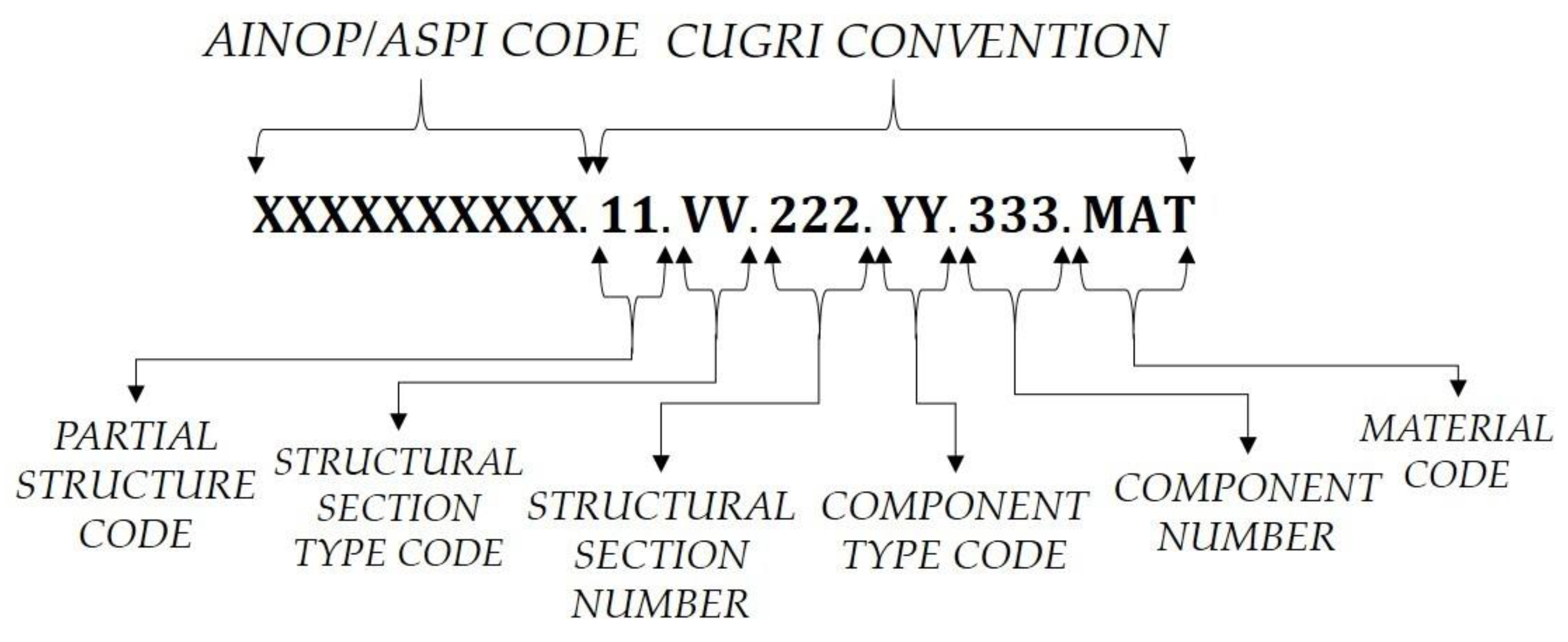
  • Law Decree No. 109 of 28 September 2018, which contains urgent measures for the city of Genoa, the safety of the national infrastructure and transport network, the seismic events of 2016 and 2017, work and other emergencies [7]. Among the requirements law there was the creation of the National Information Archive of Public Structures (AINOP—Archivio Informativo delle Opere Pubbliche), listed in Art. 13 of the aforementioned decree;
  • Guidelines for the Risk Classification and Management, Safety Assessment and Monitoring of Existing Bridges–Annexed to the opinion of the Superior Council of Public Works No. 88/2019 [8], referred as LG20 in the following, adopted through the Ministerial decree number 578 of 17 December 2020 [9]. These guidelines, defined by a commission of experts, aim to define and standardize the criteria for monitoring, assessing structural safety, and classifying the risk of existing bridges.
The evolution of the latter main rules follow tragic events: the Circular of the Ministry of Public Works of 19 July 1967 No. 6736/61/AI was published after the partial collapse of the Ariccia Bridge (18 January 1967); the LG20 was published after the tragic collapse of the Polcevera Viaduct (14 August 2018), located in Genova (Northern Italy) on the A10 highway.
The AINOP should provide:
  • Administrative data with regard to the managing corporation, roads location, relevance and use, costs incurred and to be incurred;
  • Original design and maintenance process documents;
  • Historical evolution of the constructions and the sites;
  • Safety conditions and efficiency degree of the assets, including surveillance, monitoring, and instrumental checks data.
Each asset component (bridges, tunnels, etc.) is identified by an IOP code, the public asset ID that is expected to remain unique for its entire life [10].
The LG20 aims to guarantee acceptable levels of risk, through the implementation of a multilevel knowledge process to support the maintenance management of existing bridges. The guidelines can be considered a specialized standard, in agreement with the provisions of the NTC2018, conceived to take into account the bridge vulnerability, the environmental hazards (seismic, landslide, flooding, etc.), and the exposure (traffic loads, etc.) to evaluate the infrastructural risk. The guidelines look at a quick identification of the road infrastructure to prioritize for intervention to be performed, thus ensuring savings in terms of human, economic, and time resources. For this purpose, a bridge management system (BMS) should be considered by means of a Building Information Modelling (BIM) tool.
Currently, some study cases related to the LG20 are in development [11,12,13]. The research generally highlights that the results of this approach cannot be considered as a real bridge risk classification, considering that the method assumes basic information and often the environmental conditions outweigh significantly the inspection’s results. Therefore, the LG20 could lead to a difficult definition of priority to manage in an economically sustainability way the in-depth analysis and maintenance process. Published research shows that the LG20 methodology seems to be too restrictive, due to the relevance of bridge age and environmental risk conditions in the overall Class of Attention (CdA) evaluation. This should imply detailed checks, which can lead to possible use restrictions. However, the real economic resources available and the time required to develop a full assessment of the bridges would not be compatible with the immediate service requirements.
With regard to the international context, general studies have been performed [14,15,16,17,18,19].
The Inter-University Research Center for the Prediction and Prevention of Major Hazards (CUGRI) started an activity of Applied Research with the Southern Highways Company (SAM) in 2020, in hopes of developing an innovative methodology to support the management of infrastructures located in multi-hazard and complex areas. The main goals of the deal, shared also by the current managing corporation, the Naples-Pompeii-Salerno S.p.A company, subject to management and coordination by the “Stable Consortium SIS Scpa” (SIS-SPN), are:
  • The development of an asset catalogue consistent with the representations required by the standards (Geological and geothematic cartography developed by ISPRA [20], a BIM model of the public infrastructures according to Ministerial Decree 560/2017 of 1 December 2017 [21]—which actively implemented the statement of Article 23, Comma 13, of Legislative Decree No. 50 of 18 April 2016—also known as Codice degli Appalti) and with the regulations related to the hazards that the crossed territories are interested in: seismic (NTC2018), hydrogeological (Flood Risk Management Plan (PGRA), introduced by the Community Directive 2007/60/CE [22], which contains the management framework for the areas subject to risk identified in the districts and for the areas where there may be a significant potential floods hazard and where that may be generated in the future, as well as the coastal areas subject to erosion), and volcano;
  • The creation of a multidisciplinary inspection model consistent with the ASPI manual [23] in use, with the results and the AINOP vision, and compatible with the studies and activities already in place for the LG20. In particular, maintaining the speed of the inspections, the model aims to integrate the state of deterioration recognition with a qualified analysis of the deterioration effects on the safety conditions and formal and scientific validation of the results;
  • The training of young engineers to carry out inspection activities and maintenance process management;
  • The support in the managing corporation’s management processes with risk analyses based on multidisciplinary approaches, also through further agreements with the corporations and other managers present in the area. In this context of infrastructural risk analysis and management, among the important initiatives supported by the CUGRI, the CUR_CIS2020 project was developed: “Methodologies for the punctual assessment of hydrogeological risk in highly anthropized areas and tools for regional development strategies”. Thanks to regional funding, this project saw the involvement of all Campanian universities and main infrastructure management corporations present in the regional “Strategic Infrastructure Corridor” (CIS), providing those “methodologies” of an interdisciplinary nature to be used in trans-disciplinary terms with the infrastructure management corporations [24].
This study describes a new methodology to support surveillance activities according to the LG20, which takes into account advanced/integrated BIM and GIS representations and qualified assessment of bridge safety conditions. The discussed model has been tested on the A3 highway, which connects Naples to Salerno in Southern Italy.

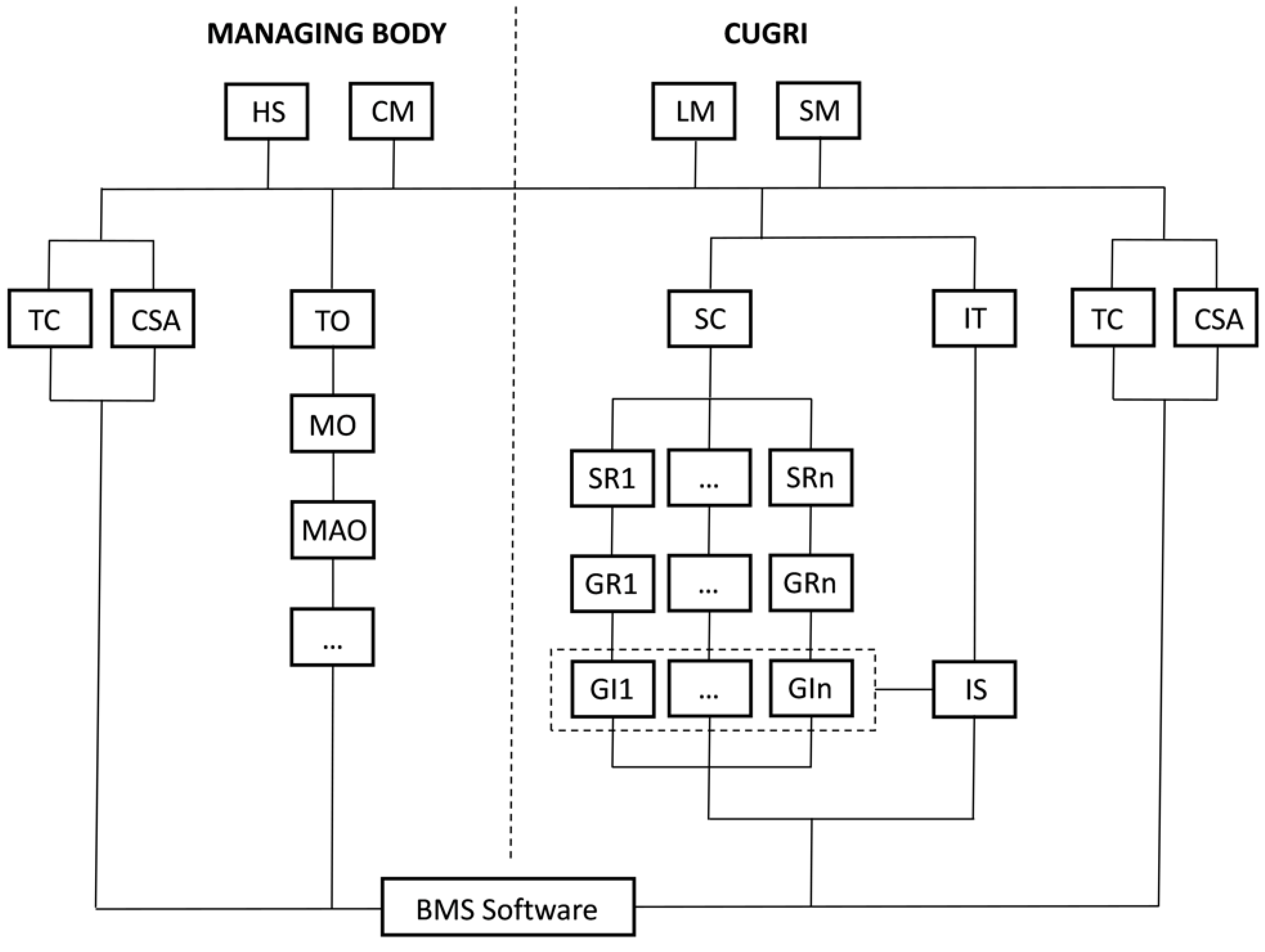
2. The Methodological Framework Proposed for Bridge Surveillance

The A3 highway is part of the European route E45 and connects the A1 “Autostrada del Sole” (northern Italy) with the A2 “Autostrada del Mediterraneo” (Southern Italy), and its extension is 52 km. Management is currently entrusted to SIS-SPN, which recently took over from SAM. The A3 highway is the public road that changed the economic development of the Campania region (Italy) after the Second World War. The highway includes 368 bridges, tunnels, and minor constructions, of which 207 bridges should be supervised according to the LG20 (Figure 2).
The bridges are characterized by different features in terms of material, age of construction, structural typology, dimensions, etc. The following figure (Figure 3) shows the material construction and the AINOP classifications.
The A3 highway plays a relevant socio-economic role and is a cultural landscape (historical panorama) for the crossed areas, such as the case of Salerno’s city (Figure 4), an access point for the UNESCO site of the Amalfi Coast.
The CUGRI and the SIS-SPN have recently launched a “Change management program”, in an effort to regulate the transition phases from surveillance methodologies based on the provisions of the Circular of the Ministry LL.PP. No. 6736/61 of 1967 and s.m.i., to the census, classification, and risk-management procedures provided by the ministerial guidelines (Ministerial Decree No. 204 of 7 January 2022 [25] and Ministerial Decree No. 247 of 8 January 2022 [26]).
For the implementation of this program, the infrastructures present on the A3 motorway section have been classified into the following macro-groups:
  • Macro Group 1 (MG1): manholes with width up to 6 m, for which the ordinary inspections will be performed on an annual basis in agreement with the “Assessment Manual-2020” developed by the CUGRI;
  • Macro Group 2 (MG2): bridges and viaducts with length up to 6 m, in which case the ordinary inspections will be conducted according to the “Assessment Manual-2020” and the Circular of the Ministry LL.PP. No. 6736/61 of 1967 on a quarterly basis;
  • Macro Group 3 (MG3): structures with length over 6 m, for which the inspections will be performed following the new LG20 and, therefore, subject to the application of the same within the terms indicated;
  • Macro Group 4 (MG4): tunnels, for which the same considerations of macro group 3 are valid;
  • Plants and Signage (P&S): services structure, for which the ordinary inspections will be performed on an annual basis according to the “Assessment Manual-2020”.
In the following table (Table 1), the quantities for each asset are summarized.
The surveillance activities are implemented through two different activities: (A) Scientific Support and Applied Research; (B) Surveillance and Inspection Activities. Activity A provides multidisciplinary activities and experimentations that involve many experts in several scientific-disciplinary sectors belonging to the CUGRI, with the scope of applying the LG20 multilevel approach, up to Level 2. In particular, the plan’s main goals are:
  • The training of the managing staff, or other group companies, who are responsible for the verification and management processes;
  • The development of a BMS platform to support the LG20 application;
  • Research for new criteria to implement the Guidelines Level 3 aims, through innovative monitoring methodologies to classify the priorities in a sustainable way;
  • The comparison of the results obtained with the LG20 (L1,L2) and the previous approach;
  • The revision of the “Manual of Surveillance Management for the A3 highway Naples-Pompeii-Salerno”.
Activity B, instead, involves the surveillance itself, in compliance with the mandatory regulatory context for the Assets that make up the infrastructure assets. In particular, the main goals of this plan are:
  • Inspections according to the new LG20 for all the infrastructure of MG3 (implementation of L1) within June 2023;
  • Attention Class assessment for all the infrastructures of MG3 (implementation of L2) within June 2023;
  • On-site inspections of the assets, conducted by specialized inspectors formed and coordinated by the CUGRI.
The inspection and monitoring activities are implemented through an integrated operational model (Figure 5) aimed at guaranteeing the dynamic quality control of the inspection process, the congruence of the surveillance results’ description, and the correctness and homogeneity of the interpretation related to the degradation phenomena observed.
In particular, as regards the managing corporation, the involved resources are the Head of Surveillance (HS), the Contract Manager (CM), the Internal Inspectors (IT), and the Internal Staff offices (traffic-TO, mobility-MO, maintenance-MAO, etc.). As regards the CUGRI, the involved resources are the Legal Manager (LM), the Scientific Manager (SM), the Technical Contact (TC), the Scientific Contact (SC), the Inspectors (I), and the Contact person for safety aspects (CSA). The on-site activities are performed by four groups of inspectors (GI), each one composed of at least two to three inspectors and a group leader (GR), coordinated and reviewed by a group scientific manager (SR). The inspection activities are planned for each quarter, specified every two weeks by the scientific coordinator (CS). The overall process is subject to internal AUDIT activities shared by a Scientific Committee, made up of professors at the associated universities, with specific expertise in the field, and the managers of the managing corporation.
All the results of the surveillance activities are managed by a BMS platform in order to allow the managing corporation to consult the state of conservation of the entire network in real-time. The BMS platform is part of the Information System (IS) of the CUGRI and is managed by a specialized technician (IT). The IS is also capable of collecting and representing monitoring data for the management of bridges and viaducts characterized by medium and medium-high Overall CdA. Figure 6 shows some screenshots of the CUGRI IS, in cloud format (right) and APP format, available for different types of devices.
Each bridge is georeferenced in a GIS platform and modeled in BIM, where each main component is represented in order to uniquely distinguish it. The BIM models of the bridges were developed with Autodesk REVIT software through a systematized procedure configured as an algorithm designed to simplify the entire process, called Scan-to-BIM [27]. It is a reverse-engineering methodology that employs a point cloud as the basis for the parametric modelling of the architectural asset. It can be organized into six sequential steps:
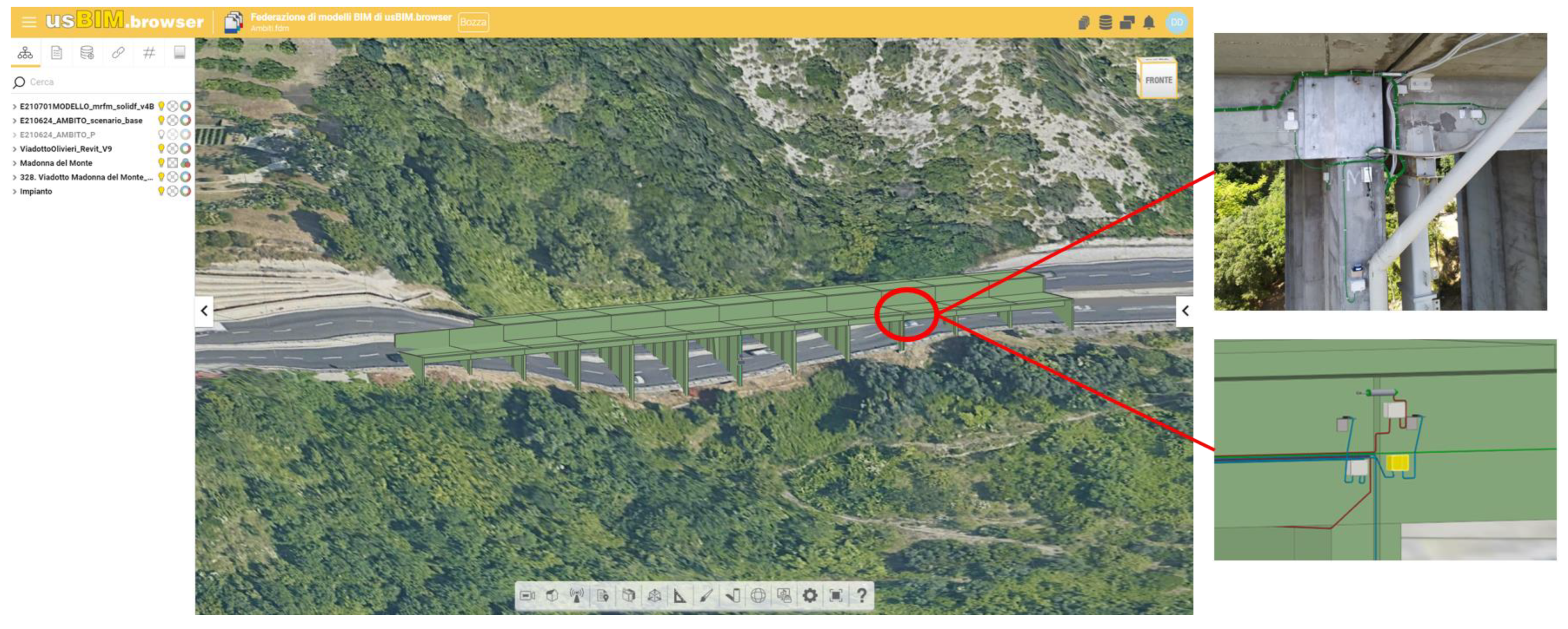
  • Three-dimensional survey (3DS), consisting of an integrated Laser Scanning–Photogrammetric survey;
  • Georeferencing (GEO);
  • Federate modelling and Shared Coordinates setting (FSC), which represents the step when several sub-models are linked by georeferencing in a unified real-world coordinate system. This step lays the foundation for effective integration of BIM and tridimensional GIS systems;
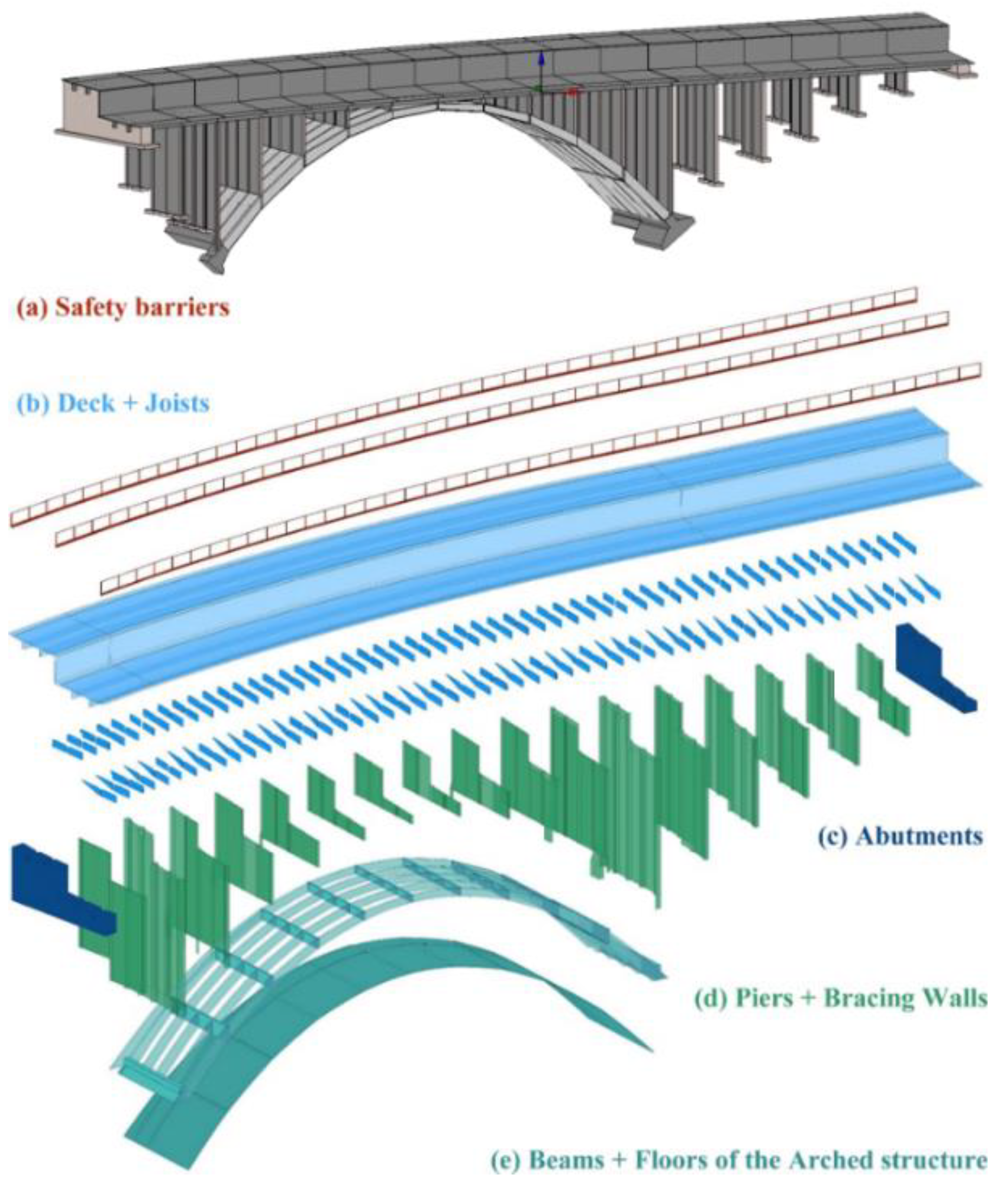
  • Structural modelling (STR), which consists of an accurate architectural and/or mechanical modelling of the structure;
  • Level of Information enhancement (LOI), which together with the Level of Geometric Detail (LOG) defines the general concept of Level of Development (LOD). The LOI may include a vast amount of data in the form of parameters, which contribute to describing different aspects of a smart object. For the study’s goal, it has been considered LOD C [28] / LOD 300 [29];
  • Open BIM Models Exportation (IFC).
When the original design drawings or in general the geometric information are known, the procedure can start directly from the second step (GEO).
The BMS platform development also involves the participation of “Acca software S.p.a” [30], through the cloud service usBIM.platform [31], which is a digital collaborative software, BIM-based, designed to rationalize all the activities related to the construction field, starting from the design, up to the construction and subsequent management. The main strong point of the service is the possibility to assemble different models in a unique geographic vision, which is necessary to develop a multidisciplinary approach. Other strong points are:
  • The use of open formats files, such as the IFC standard [32];
  • It can be accessed every time and everywhere directly from the web, through appropriate credentials;
  • It is possible to see all the BIM models shared on the database in real time;
  • The files can be modified by authorized users, through specific editing services.
Figure 7 shows a screenshot of the BMS platform where it is possible to see a BIM model located on a map, for which real-time instrumental monitoring activities are in progress, with the scope of bridge surveillance.
Figure 8 describes an example of a BIM model hierarchy.
Each bridge component is identified by an alphanumeric code (ID) (Figure 9) that uniquely links the component to its inspection sheets, according to Annex B of the Guidelines [8].

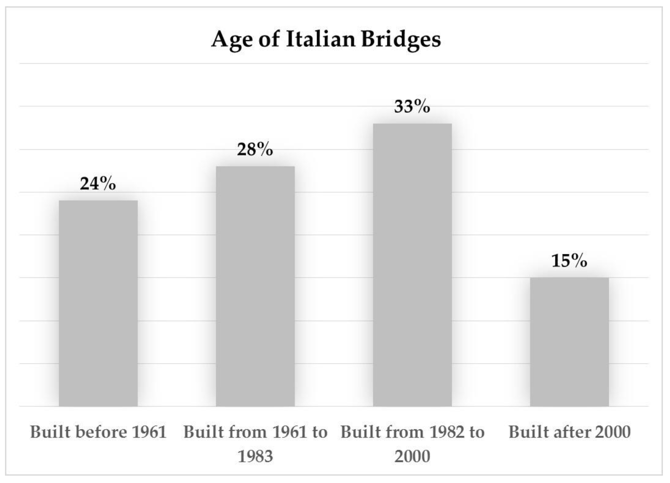
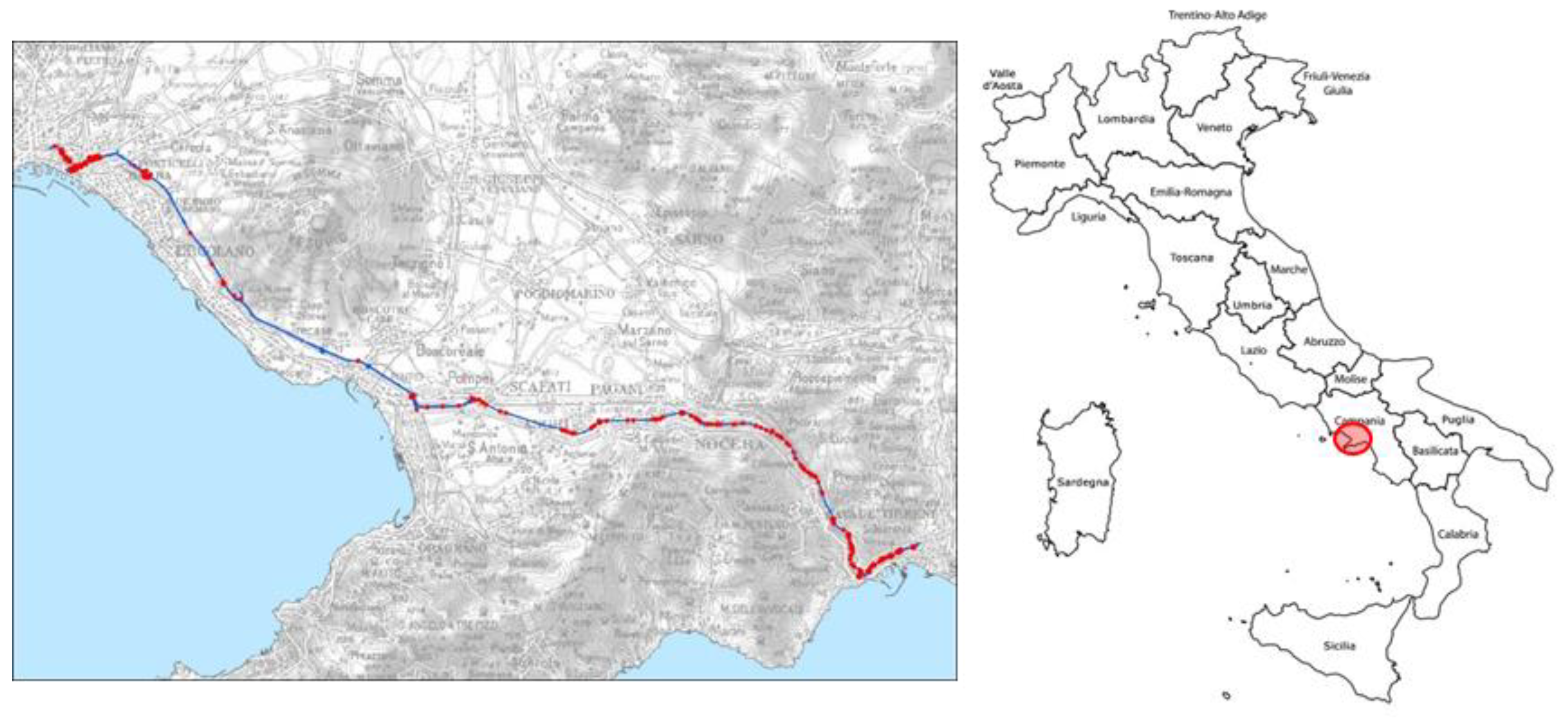
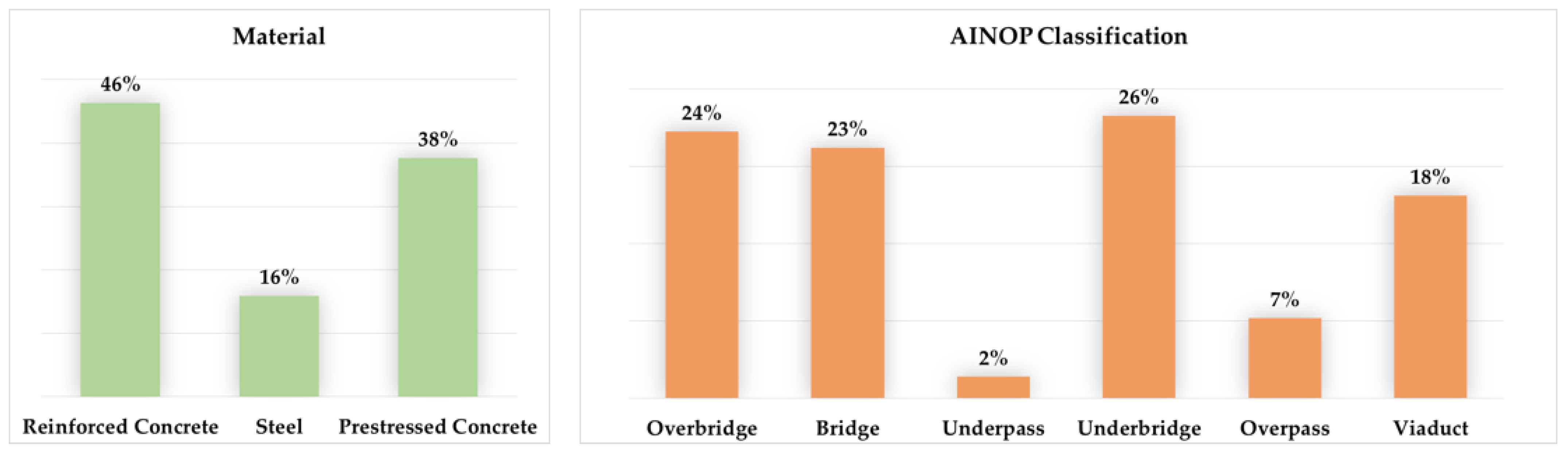
3. Preliminary Results and Considerations

The CUGRI has been involved in Surveillance activities since 2020, during which a large amount of data were collected for both ordinary inspections and the LG20 requirements.
The adopted methodology for the ordinary inspections leads to evaluating the bridge priority index. Such an index considers a degradation score, assigned to each type of defect in the range 10 (the defect will not evolve into another defect) to 70 (immediate interventions), the defect extension (punctual DP–widespread DD), and the evolution rate (slow EL–fast ER). The bridge priority indices (low priority A–high priority E) are evaluated as in the following matrix (Table 2).
In particular, the CUGRI methodology for ordinary inspections takes into account the degradation score defined in the guideline adopted by ASPI (Italian highway main management corporation) in 2015 [33] and a qualified assessment of the local and overall safety conditions. The priority indices matrix has been instead elaborated by CUGRI taking into account the available historical inspection data.
The results (Figure 10) of 2022 ordinary inspections highlight that most of the MG3 bridges (62%) are characterized by a degradation score between 43 and 50, while 4% of the bridges result in high priority (E) and 22% in medium-high and medium (D-C). The obtained priority indices seem to describe quite well the real safety conditions checked by an overall expert judgement in the case of the A3 highway. Moreover, the latter indices are consistent with detailed structural checks performed by independent organisms for the worst cases.
Figure 11 describes the Structural and Foundational CdA and a preliminary forecast of the Overall CdA in terms of the percentage of MG3 bridges in the case of the LG20 rules. The results highlight that 73% of bridges are characterized by a medium-to-high CdA, while 99% of the bridges present an overall CdA from medium to high, with a peak of 45% of high overall CdA. The approach to assess Level 2 will be complemented in 2023 by interdisciplinary contributions such as geological, geomorphological, and geotechnical knowledge.
A large amount of data related to the ordinary inspection are currently available, while the LG20 approach is only at the beginning. Considering that the managing body needs to assure a homogeneous maintenance policy with finite economic and time resources also in this transient period, it is relevant to have the possibility to supply the absence of the LG20 data with ordinary inspections. Moreover, with regard to the LG20 experimental period, it is relevant to assess the effectiveness of the single steps considered in the LG20.
The comparison between the results obtained by the ordinary inspection and the LG20 ones highlights similar values in terms of degradation score and structural and foundational CdA, in a range from medium-to-high classes. However, the overall CdA seems to be too penalizing due to the relevance of local hazards in the evaluation of the process using the class and logical operator approach. Thus, the LG20 approach, unlike ordinary inspections, facilitates a more detailed defect identification of the single structural components.

4. Conclusions

This paper has focused on the application of the LG20 Guide Lines in terms of surveillance activity by describing a new methodology on the A3 highway (Southern Italy) thanks to a joint applied research project between the CUGRI and the managing corporations (SAM and SIS-SPN).
The project developed a multidisciplinary-based model capable of dynamically managing a bridged database to support risk assessment activities, according to the current standard requirements. Within this, an innovative surveillance process was tested to assure robust evaluations through expert judgments and the training of young specialists. The surveillance model considers a BMS capable of integrating GIS, BIM, and Risk representations within the CUGRI Information System.
The comparison of the results obtained by the ordinary and LG20 inspection methodologies leads to the following preliminary considerations:
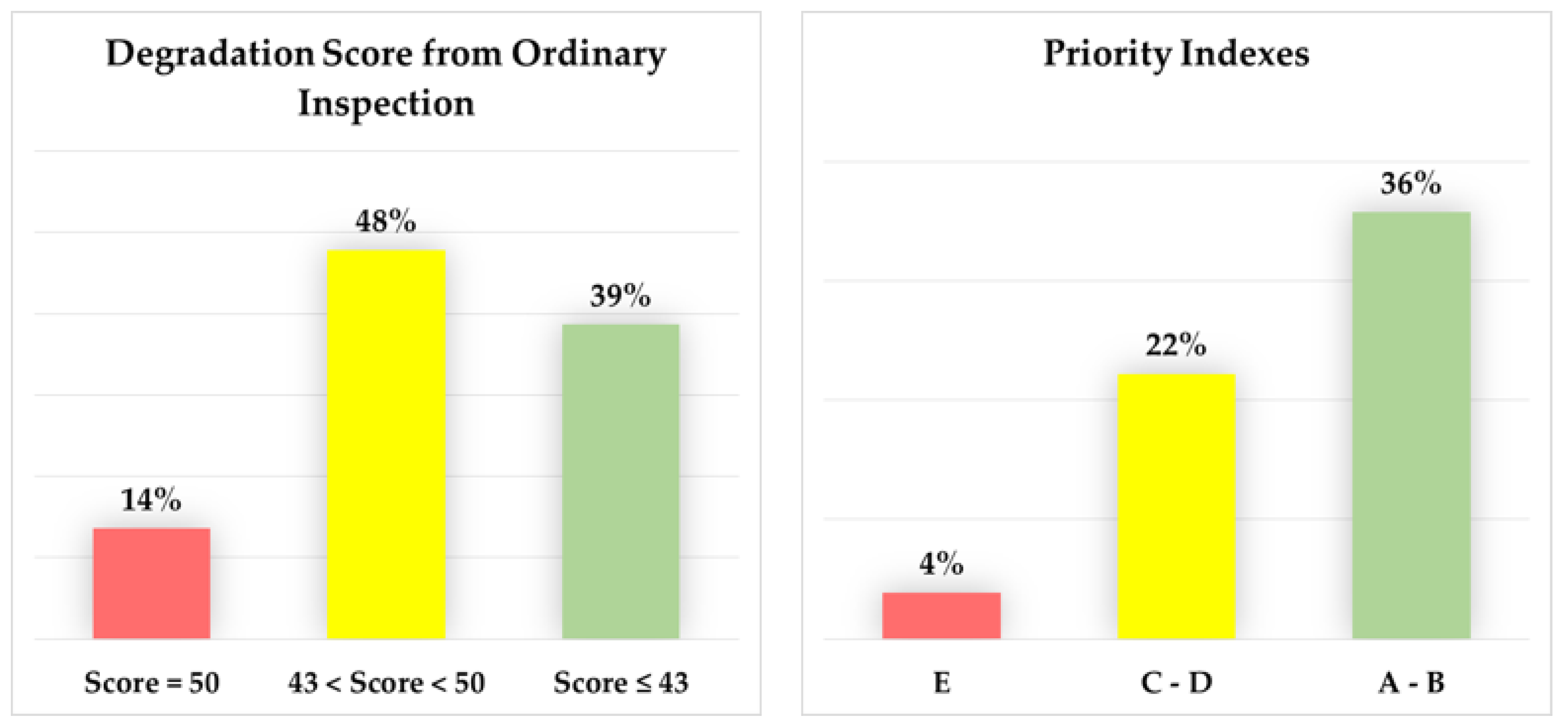
  • The methodologies based on the LG20 and the CUGRI ordinary inspections led to similar results in terms of Structural and Foundational CdA, i.e., defect indices, even if with different efforts both for time and economic resource requirements;
  • The definition of the priority index through the CUGRI ordinary inspection method seems to be consistent with the experts’ judgment results and with the punctual check, made by third parties, of infrastructure in worse condition;
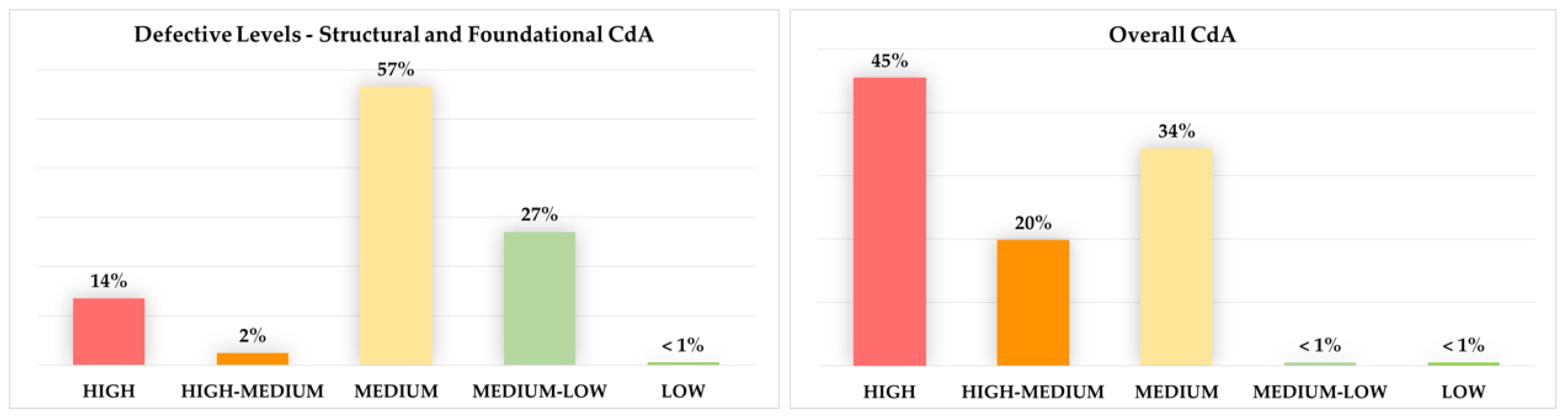
  • In the case of the LG20, the local Hazard conditions were the most relevant in the overall CdA evaluation compared to the structural and foundational CdA;
  • The LG20 methodology led to a more detailed defect identification of the single structural components, compared to the ordinary inspections.
The experimentation that was carried out highlight the need of developing more insights studies in order to calibrate the LG20 model better, based on the approach for class and logical operators, to evaluate the overall CdA. Moreover, it is necessary to consider the effects that the application of the LG20 methodology could have on the local managing corporations, which generally are not equipped to implement high surveillance and manage the obtained results.

Author Contributions

Methodology and supervision, L.P.; investigation L.P., C.L. and C.M.D.G.; software C.M.D.G. All authors have read and agreed to the published version of the manuscript.

Funding

CUGRI (Inter-University Research Center for the Prediction and Prevention of Major Hazards).

Data Availability Statement

BIM models and software should be considered classified materials and property of SIS-SPN. Interested Researchers can ask CUGRI ([email protected]) about the possibility to participate in the project.

Acknowledgments

The research was conducted thanks to the willingness to develop innovative surveillance processes and young specialists to allow fruitful maintenance process of road infrastructures in complex areas by the A3 managing corporations (SAM and SIS-SPN). The activities were conducted and led by the CUGRI.

Conflicts of Interest

The authors declare no conflict of interest.

References

  1. Ministry of Infrastructure and Transport. Operational Plan for Infrastructure Development and Cohesion Fund 2014–2020 (Law n. 190 of 23 December 2014, c. 703–Deliberate CIPE n. 25 of 10/08/2016); Ministry of Infrastructure and Transport: Rome, Italy, 2019. [Google Scholar]
  2. Pierluigi, B. Dossier UPI, Bridges: The Results of the Monitoring of the Provinces. 2019. Available online: https://www.provinceditalia.it/wp-content/uploads/2019/08/Dossier-Province-monitoraggio-ponti-2-.pdf (accessed on 1 February 2023).
  3. Ministry of Public Works. Circular of the Ministry of Public Works 19 July 1967 N° 6736/61/A1. Checking of the Stability Conditions of Road Structures; Ministry of Public Works: Roma, Italy, 1967. [Google Scholar]
  4. Ministry of Public Works. Circular of the Ministry of Public Works 25 February 1991 n. 34233, Law 2 February 1974, n. 64, Art. 1, Ministerial Decree 4 May 1990. Instructions Relating to the Technical Regulations of Road Bridges; Ministry of Public Works: Roma, Italy, 1991. [Google Scholar]
  5. Ministry of Infrastructure and Transport. DM 17/01/2018, Updating of the “Technical Standards for Buildings (NTC2018)”; Ministry of Infrastructure and Transport: Rome, Italy, 2018. [Google Scholar]
  6. Ministry of Infrastructure and Transport. Circular of the Ministry of Public Works 21 January 2019 N° 7 C.S.LL.PP. Instructions for the application of the «Update of the “Technical Standards for Constructions”» Referred to the Ministerial Decree 17 January 2018; Ministry of Infrastructure and Transport: Rome, Italy, 2019. [Google Scholar]
  7. Ministry of Education, University and Research. Law Decree 109/2018, Urgent Provisions for the City of Genoa, the Security of the National Infrastructure and Transport Network, the Seismic Events of 2016 and 2017, Work and Other Emergencies (18G00137); Ministry of Education, University and Research: Rome, Italy, 2018. [Google Scholar]
  8. Ministry of Infrastructure and Transport, Superior Council for Public Works. Guidelines for Risk Classification and Management, Safety Assessment and Monitoring of Existing Bridges; Ministry of Infrastructure and Transport, Superior Council for Public Works: Rome, Italy, 2020. [Google Scholar]
  9. Ministry of Infrastructure and Transport. Ministerial Decree 578/2020, Adoption of Guidelines for Risk Management of Existing Bridges and for the Definition of Requirements and Indications relating to the Dynamic Monitoring System; Ministry of Infrastructure and Transport: Rome, Italy, 2020. [Google Scholar]
  10. The National Information Archive of Public Structures—AINOP. Available online: https://ainop-coll.mit.gov.it/portale/#/ (accessed on 1 February 2023).
  11. Santarsiero, G.; Masi, A.; Picciano, V.; Digrisolo, A. The Italian Guidelines on Risk Classification and Management of Bridges: Applications and Remarks on Large Scale Risk Assessments. Infrastructures 2021, 6, 111. [Google Scholar] [CrossRef]
  12. Buratti, G.; Celati, S.; Cosentino, A.; Gaudioso, D.; Mazzatura, I.; Morelli, F. The New Guidelines of Italian Ministry of Infrastructures for the Structural Risk Classification of Existing Bridges: Genesis, Examples of Application and Practical Considerations. In Proceedings of the 1st Conference of the European Association on Quality Control of Bridges and Structures (EUROSTRUCT 2021), Padua, Italy, 29 August–1 September 2021; Springer: Cham, Switzerland, 2022; Volume 200, pp. 835–844. [Google Scholar] [CrossRef]
  13. Capogna, M.; Salvatore, W.; Renzi, E.; Tamasi, G. Guidelines for the classification and management of risk, for the evaluation of safety and the monitoring of existing bridges” An automatic calculation model of the seismic attention class optimized for the use of cloud computing services. Procedia Struct. Integr. 2023, 44, 705–712. [Google Scholar] [CrossRef]
  14. Gul, W. State of the Art Health Monitoring Systems of Bridges. SSRN 2019. [Google Scholar] [CrossRef]
  15. Abdallah, A.M.; Atadero, R.A.; Ozbek, M.E. A state-of-the-art review of bridge inspection planning: Current situation and future needs. J. Bridge Eng. 2022, 27, 1–20. [Google Scholar] [CrossRef]
  16. Jin, X. Design of bridge health monitoring system based on B/S mode and SOA architecture. Int. J. Biom. 2022, 14, 199–207. [Google Scholar] [CrossRef]
  17. Mufti, A.; Raeisi, F.; Khalid, H.; Horosko, A.; Bakht, B. A case for adding an inspection level related to structural health monitoring (SHM) for bridge evaluation. Can. J. Civ. Eng. 2021, 48, 443–446. [Google Scholar] [CrossRef]
  18. Wang, Q.A.; Zhang, C.; Ma, Z.G.; Ni, Y.Q. Modelling and forecasting of SHM strain measurement for a large-scale suspension bridge during typhoon events using variational heteroscedastic Gaussian process. Eng. Struct. 2022, 251, 113554. [Google Scholar] [CrossRef]
  19. Wang, Q.A.; Wang, C.B.; Ma, Z.G.; Chen, W.; Ni, Y.Q.; Wang, C.F.; Yan, B.G.; Guan, P.X. Bayesian dynamic linear model framework for structural health monitoring data forecasting and missing data imputation during typhoon events. Struct. Health Monit. 2022, 21, 2933–2950. [Google Scholar] [CrossRef]
  20. CARG Project. Italian Geological and Geothematic Cartography. ISPRA. Available online: https://www.isprambiente.gov.it/it/progetti/cartella-progetti-in-corso/suolo-e-territorio-1/progetto-carg-cartografia-geologica-e-geotematica (accessed on 1 February 2023).
  21. Ministry of Infrastructure and Transport. Ministerial Decree 560/2017, Modality and Timings of the Progressive Introduction of Methods and Electronic Modeling Tools for Buildings and Infrastructures (BIM Decree); Ministry of Infrastructure and Transport: Rome, Italy, 2017. [Google Scholar]
  22. PGRA—Italian Flood Risk Management Plan, Appennino Meridionale District. Available online: https://www.distrettoappenninomeridionale.it/index.php/pdg-alluvioni-menu (accessed on 1 February 2023).
  23. ASPI Autostrade per l’Italia. Surveillance Manual for Major Assets, Visual Inspection (Draft); ASPI Autostrade per l’Italia: Rome, Italy, 2020. [Google Scholar]
  24. Petti, L.; Nuccio, F.; Caliendo, C.; Ferlisi, S.; Guida, D. Methodologies for the Punctual Assessment of Hydrogeological Risk in Heavily Anthropized Areas and Tools for Regional Development Strategies; Application to the case study of the “strategic infrastructural corridor” (CIS), at a regional level of Salerno-Cava de’ Tirreni motorway section (Naples—Salerno A3) and other road infrastructures downstream of the same; UniorPress: Naples, Italy, 2021. [Google Scholar]
  25. Ministry of Infrastructure and Transport. Ministerial Decree 204/2022, Adoption of the Guidelines for the Risk Management of Existing Bridges and of the Operating Instructions for the Application of the Guidelines Themselves; Ministry of Infrastructure and Transport: Rome, Italy, 2022. [Google Scholar]
  26. Ministry of Infrastructure and Transport. Ministerial Decree 247/2022, Approval of the Guidelines for Risk Classification and Management, Safety Assessment and Monitoring of Existing Tunnels; Ministry of Infrastructure and Transport: Rome, Italy, 2022. [Google Scholar]
  27. Sanseverino, A.; Messina, B.; Limongiello, M.; Guida, C.G. An HBIM Methodology for the Accurate and Georeferenced Reconstruction of Urban Contexts Surveyed by UAV: The Case of the Castle of Charles V. Remote Sens. 2022, 14, 3688. [Google Scholar] [CrossRef]
  28. UNI 11337-ITA; Italian Regulations for the BIM Methodology. Italian National Unification Body: Rome, Italy, 2017. Available online: https://uni.com/index.php (accessed on 1 February 2023).
  29. AIA G202-2013; Project Building Information Modeling Protocol Form. The American Institute of Architets: Washington, DC, USA, 2013. Available online: https://www.aia.org/ (accessed on 1 February 2023).
  30. Acca Software, S.p.a. Available online: https://www.acca.it/ (accessed on 1 February 2023).
  31. Acca Software, S.p.a. BIM Management System usBIM. Available online: https://www.acca.it/bim-management-system (accessed on 1 February 2023).
  32. UNI EN ISO 16379-1; Industry Foundation Classes (IFC) for Data Sharing in the Construction and Facility Management Industries. Italian National Unification Body: Rome, Italy, 2020. Available online: https://uni.com/index.php (accessed on 1 February 2023).
  33. ASPI Autostrade Per L’Italia. Surveillance Manual: The Scheduled Maintenance of the Road Assets; SPEA Engineering: Milan, Italy, 2015. [Google Scholar]
Figure 1. Age of Italian bridges.
Applsci 13 04975 g001
Figure 2. Bridges and viaducts (red circle) on the A3 highway (blue line).
Applsci 13 04975 g002
Figure 3. Statistics on the material (left) and AINOP classification (right) of A3 bridges and viaducts.
Applsci 13 04975 g003
Figure 4. Arch bridge located near Salerno (Southern Italy).
Applsci 13 04975 g004
Figure 5. Operating model flow chart (for codes see text).
Applsci 13 04975 g005
Figure 6. CUGRI Information System (IS), cloud (left), and APP (right) format.
Applsci 13 04975 g006
Figure 7. BMS platform.
Applsci 13 04975 g007
Figure 8. Example of BIM model–Olivieri Bridge.
Applsci 13 04975 g008
Figure 9. Bridge single element ID code.
Applsci 13 04975 g009
Figure 10. Degradation Score and Priority Index evaluated by Ordinary Inspection Method.
Applsci 13 04975 g010
Figure 11. Structural and Foundational CdA and Overall CdA forecast by LG20 approach.
Applsci 13 04975 g011
Table 1. Summary of classification, description, and quantity of the A3 highway assets for each macro group.
Macro GroupsClassificationDescriptionQuantity
1Manholes and Tunnels (L < 6 m)Manholes27
2Bridges, Overpasses and Underpasses (L < 6 m)Bridge and Underpass120
3Bridges and Viaducts (L > 6 m)Bridge and Viaduct207
4Tunnels (L > 6 m)Tunnels14
Table 2. Priority indices matrix, according to CUGRI methodology.
EXTENTSCORE
40–435060
ELERELERELER
DPABCDDE
DDBCDEEE
Disclaimer/Publisher’s Note: The statements, opinions and data contained in all publications are solely those of the individual author(s) and contributor(s) and not of MDPI and/or the editor(s). MDPI and/or the editor(s) disclaim responsibility for any injury to people or property resulting from any ideas, methods, instructions or products referred to in the content.

