Article

Exhumation of the Higher Himalaya: Insights from Detrital Zircon U–Pb Ages of the Oligocene–Miocene Chitarwatta Formation, Sulaiman Fold–Thrust Belt, Pakistan

1
State Key Laboratory of Tibetan Plateau Earth System, Resources and Environment, Institute of Tibetan Plateau Research, Chinese Academy of Sciences, Beijing 100101, China
2
University of Chinese Academy of Sciences, Beijing 101408, China
3
Department of Earth Sciences, COMSATS University Islamabad, Abbottabad Campus, Abbottabad 22010, Pakistan
4
Department of Earth Sciences, Abbottabad University of Science and Techology, Abbottabad 22500, Pakistan
5
Department of Earth Sciences, University of Haripur, Haripur 22620, Pakistan
6
Department of Earth Sciences, Karakoram International University, Gilgit 15100, Pakistan
*
Authors to whom correspondence should be addressed.
Appl. Sci. 2023, 13(6), 3418; https://doi.org/10.3390/app13063418
Submission received: 20 February 2023 / Revised: 3 March 2023 / Accepted: 4 March 2023 / Published: 8 March 2023
(This article belongs to the Section Earth Sciences)

Abstract

:
This study reports the detrital zircon U–Pb ages of the post collisional Chitarwatta Formation, exposed along the western margin of the Indian plate at the Sulaiman fold–thrust belt (SFB), Pakistan. The Chitarwatta Formation overlies the shallow marine carbonate sequence of the Kirthar Formation and represents an Oligocene–Miocene transitional marine sequence. The sequence consists of sandstone, siltstone, and mudstone. The sandstone consists predominantly (79–82%) of quartz grains. The framework grains are sub-angular to sub-rounded and show recycled orogenic provenance. The detrital zircon U–Pb age data show the dominant population between 390 Ma and ~1100 Ma, which is ~70% of the total population. In addition to this, a significant percentage of the younger detrital ages exist between ~40 Ma and ~120 Ma. This younger age cluster indicates the northern sources, including the Kohistan–Ladakh arc (KLA) and Karakoram block (KB), whereas the provenance for the 390–1100 Ma detrital zircon is likely the Higher Himalaya (HH), with contribution from Tethyan Himalaya (TH). This post-collisional scenario suggests that the Chitarwatta Formation received detritus from the northern sources through a drainage system, named as the Indus drainage system. A comparison with the coeval units in the north (Murree Formation, Dagshai Formation, and Dumre Formation) suggests that the sediments may have been delivered through the same drainage system that shares similar detritus. Relying on the contribution of the HH detritus, we propose that the HH uplifted during the Oligocene–Miocene along the Main Central Thrust (MCT) and provided detritus to the foreland basin.

1. Introduction

The collision of the Indian and Eurasian plates can be observed physically from the development of the Himalayas and subsequent formation of the foreland basin [1]. The tectonic history of the processes occurring in the past, during the mountain building and erosion, are likely stored by the detrital sediments of the foreland basin. The reconstruction of the paleo-tectonic processes of the fold–thrust belts and foreland basins can be determined by the detailed study of the detrital sediments in the foreland [1,2,3]. The detrital sediments can be helpful in finding the origin of the sedimentary rocks, rise and fall of sea level, and history of the orogeny and tectonic basins [4,5,6,7]. Modern techniques (i.e., U–Pb geochronology) have been extensively used to investigate the sedimentary records of foreland basins [8,9,10,11,12,13,14,15,16,17], in order to confine their provenance and find out the maximum ages of deposition. Geochronology of detrital zircons is a very powerful tool in finding the absolute record of provenance of sediments. This provenance can be further used to construct the paleogeography of blocks in geological time [18].
The Himalayan foreland basin sediments have attracted enormous attention, for constraining the timing of the India–Eurasia collision and the exhumation history [1,19,20]. This collision was followed by the evolution of the mountain belts, due to the propagation of the thrust sheets. Sedimentary geochronology has been performed to find out the source of the Chitarwatta Formation and eventually the exhumation history of the Himalayan blocks and its foreland. Structurally, our study area is located in the eastern Sulaiman fold–thrust belt, which occupies a position along the western margin of the Indian plate (Figure 1A,B).
The Sulaiman fold–thrust belt consists of Permian to Eocene sediments, which are overlain by the Oligocene to Miocene molasses of the Himalaya (Figure 1B,C). The area has been studied in detail with respect to geochemistry, petrography, structure and tectonics, paleontology, and sedimentology [23,24,25]. However, in terms of modern detrital geochronology, the data are very limited [26]. Therefore, in this study, we adopted the modern U–Pb geochronology to study the Chitarwatta Formation, to provide an insight to the exhumation of the Higher Himalayan slab.

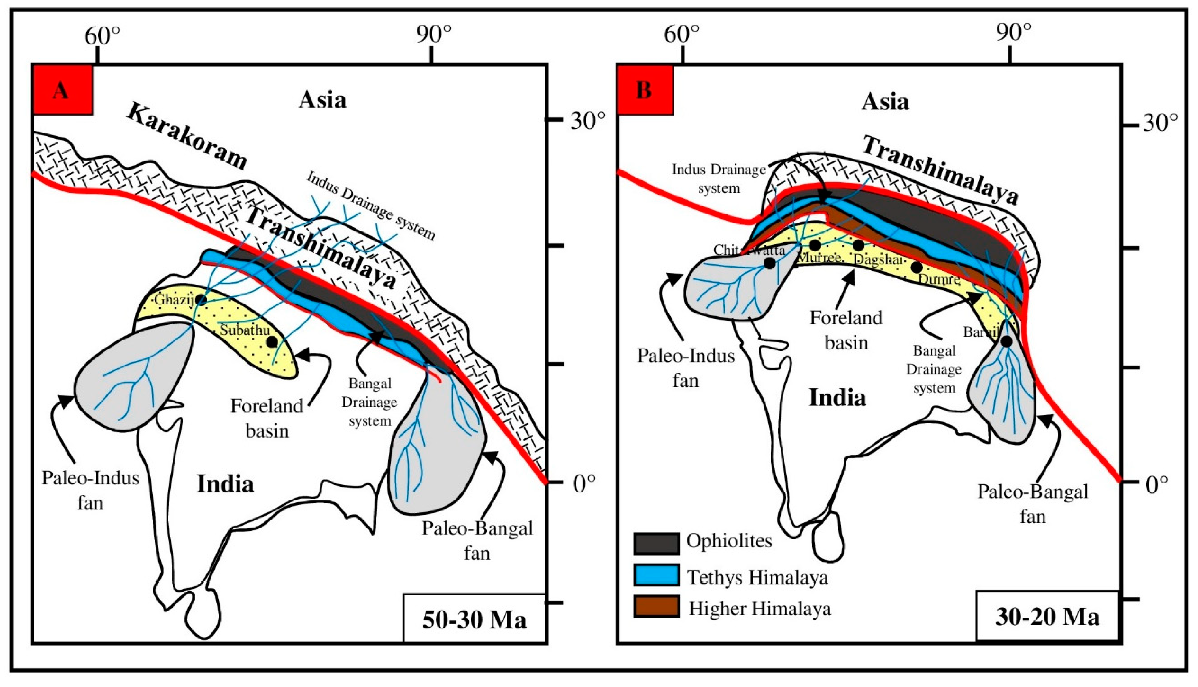
2. Geological Setting

In the Cenozoic, head-on and oblique collisions between the Indian and Eurasian plates, resulted in the rise of the Himalayas in the north and western margins of the Indian plate [1]. Following the closure of the Tethys Ocean between them, these plates came into contact via the Main Mantle Thrust (MMT) in the northwest and the Chaman transform fault in the west. As a result, the foreland basin in the MMT’s footwall was created [3]. Since the collision, the direction of sediment transport reversed from south to north, and sediments from the Indian and Eurasian Plates began migrating in that direction. Owing to the exhumation of the Himalayas, they were eroded, transported, and deposited in the foreland basin [27].
The Sulaiman fold–thrust belt (Figure 1), which extends from the NW Himalayas southward, delineates the western limit of the Indian plate in Pakistan [28]. It is an active tectonic zone, with a width of more than 300 km, having a lobate shape, and covering an area of over 200,000 km2 [28,29,30]. After the two plates made an oblique collision, a strike slip motion caused this section of the Himalayas to develop [31,32]. The thrusting and southern movement of these thrust sheets, which are confined by the tear-faults along the basal decollement, resulted in the lobe-like structure in the Sulaiman range [33,34]. In contrast to the main convergent zone, connected to the Salt Ranges and Potwar Basin, this Himalayan zone is distinct, due to the combined action of translational movement and compressional stresses [33].
The Muslim Bagh Ophiolites were obducted during the Cretaceous [35] or Eocene period [36], marking the earliest collision event. The collision of India and Asia resulted in the formation of a foredeep basin to the east of the Sulaiman range [33]. The Himalayan thrust system is in the north, the Kirthar Ranges are in the south, the Indus foredeep and Sulaiman basin are in the east, and the left lateral Chaman transform boundary is in the west, making the Sulaiman fold belt a prime location [37]. The deformation pattern in the Sulaiman fold belt is thought to be related to passive roof duplex, fault propagation, fault bending folds, and stacked anticlines [25,38]. In contrast, some researchers consider it to be associated with a positive flower structure, and thick-skinned deformation [37,39,40]. Due to two decollement surfaces that were provided by salt from the Eocene and shale from the Precambrian respectively, the Sulaiman fold–thrust belt has a peculiar and severe deformation style. The Eo-Cambrian Salt provides a single decollement surface in the Potwar Basin and Salt Ranges, making it relatively less intense [41].
There are four major local faults in the Mughalkot segment (Figure 1C). The Takht-e-Sulaiman fault, which is left lateral and trends north-south, is found in the westernmost point of this segment and cuts through rocks from the upper and lower Cretaceous. Rocks from the Ghazij group are thrown over the Kirthar group by the western Domanda fault, which is to its east. The Pleistocene–Oligocene Siwaliks and the Eocene Kirthar group are divided by the third significant local fault, known as the eastern Domanda fault, which is further to the east. The fourth fault, which separates the Siwaliks and recent alluvium, is located towards the eastern Sulaiman Basin. Due to extensive deformation, these faults are accompanied by anticlines and synclines [22].

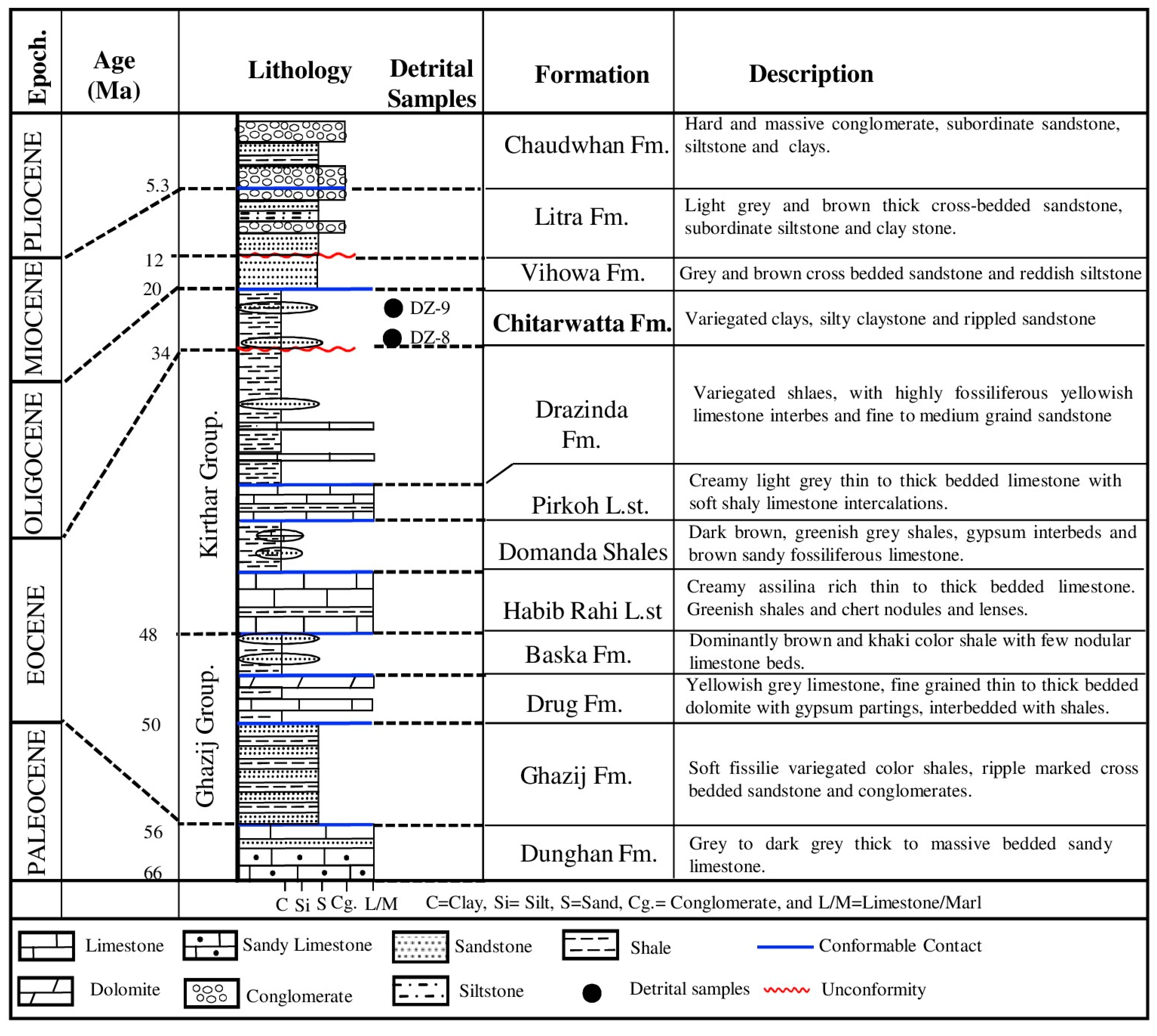
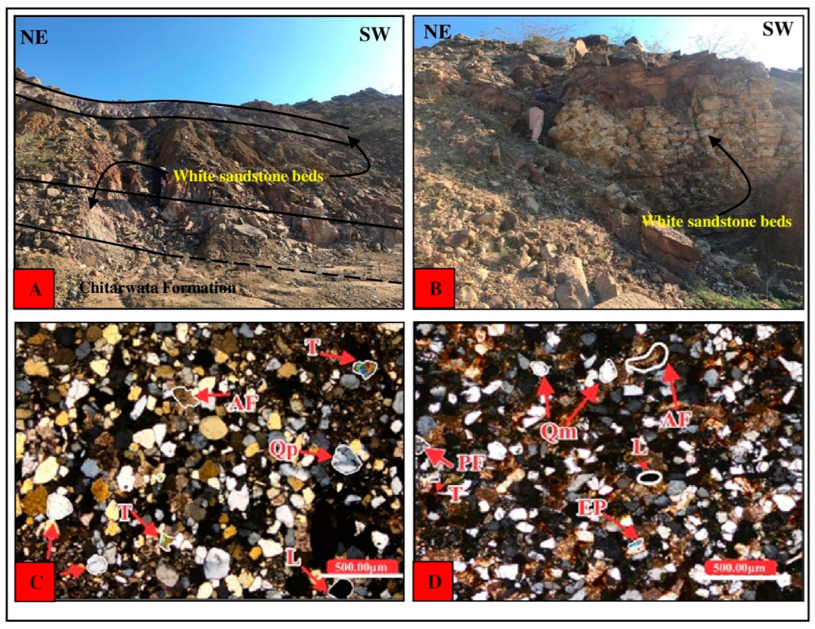
3. Stratigraphy and Petrography

The Chitarwatta Formation overlies the Eocene Kirthar Group in the Mughalkot section and is overlain by the Vihowa Formation (Figure 2). Lithologically, the Chitarwatta Formation consists of sandstones, siltstones, and mudstones. The flaser bedded sandstone is observed in the lower part, which is whitish, orange, and maroon (Figure 3A,B). The sandstone beds are internally ripple laminated. The sandstone is fine- to coarse-grained. Up-section the sandstones and mudstones are observed as interbedded. The sandstone intercalations are thin bedded, with an average thickness of 5–10 cm. The sandstone and clay intercalations are overlain by the parallel laminated sandstones. The whitish color of the sandstone is prominent. In its upper part, the Chitarwatta Formation is dominantly comprised of mudstones, which are approximately 180 m thick. The mudstones are varied in color, including greenish, brown, and red.
The samples DZ-8 and DZ-9 are representative sandstones collected from the Chitarwatta Formation. The average composition of the framework grains is: quartz (~79–82%), feldspar (~6.42–11.8%), and lithics (8.79–11.56%) (Table 1). The quartz grains are monocrystalline. The feldspar grains are mainly alkali feldspar (Figure 3C,D). Plagioclase feldspar grains are also observed. The lithics are mainly sedimentary in nature. The accessory minerals observed in the thin sections are epidote and tourmaline (Figure 3C,D). The matrix is mainly composed of calcite (~10–15%) and clay (~3%). The grains are sub-angular to sub-rounded, with low–medium sphericity (Table 2). The fabric is mainly grain supported, with planar-pointed contacts. The grains are texturally and mineralogically mature and well sorted. The percentage of the framework grains plotted on the QFL ternary diagram shows recycled orogen provenance (Figure 4).

4. U–Pb Geochronology

Sampling and Methods

Two samples were collected from the Chitarwatta Formation exposed in the Mughalkot section of the Sulaiman fold belt, for further processing in the lab for geochronology. These samples were taken into the lab for crushing, and consequently treating with heavy liquids. After this traditional treatment, a magnetic separator was used to separate the detrital grain of zircon from the samples. Double glue tap was used to mount these grains. To prepare the grains for polishing and analysis, epoxy resin was filled in a closed container. After this, pure alcohol and dilute nitric acid was used to remove the dust and dirt from their surface. Before spot selection for laser ablation, images were recorded by cathode luminescence (CL), to avoid the complex structure. This imaging is important to identify the internal structure [43]. The final stage of this procedure was to load the samples into the laser ablation system (LAS), after passing them through the above described stages. The LAS is a part of an induced coupled plasma mass spectrometer (ICP-MS). The outer portion of the complex core and rim internal structure of the grains was selected, for spot analysis. This whole lab procedure was conducted at the Institute of Tibetan Plateau Research, located at the University of Chinese Academy of Sciences (UCAS), China. In order to know the ages of the grains, and for calibration, glass standard 610, Plesovice Zircon, and 91500 were used as standards. The mean age of the standard Zircon is already known, i.e., 337 ± 0.37 Ma for Plesovice [44] and mean age of 91500 is 1064 ± 0.6 Ma. For standardizing and reduction, the Glitter software (version 4.0) was used to process the raw data. The final analysis of the zircons included ages with a discordance of less than 10%. The zircons with ages less than 1000 Ma were assigned on the basis of 206Pb/238U. Similarly, those grains having ages greater than 1000 Ma were assigned on the basis of 207Pb/206Pb. Probability density plots (PDP) were used to represent the final ages on the density plotter software.

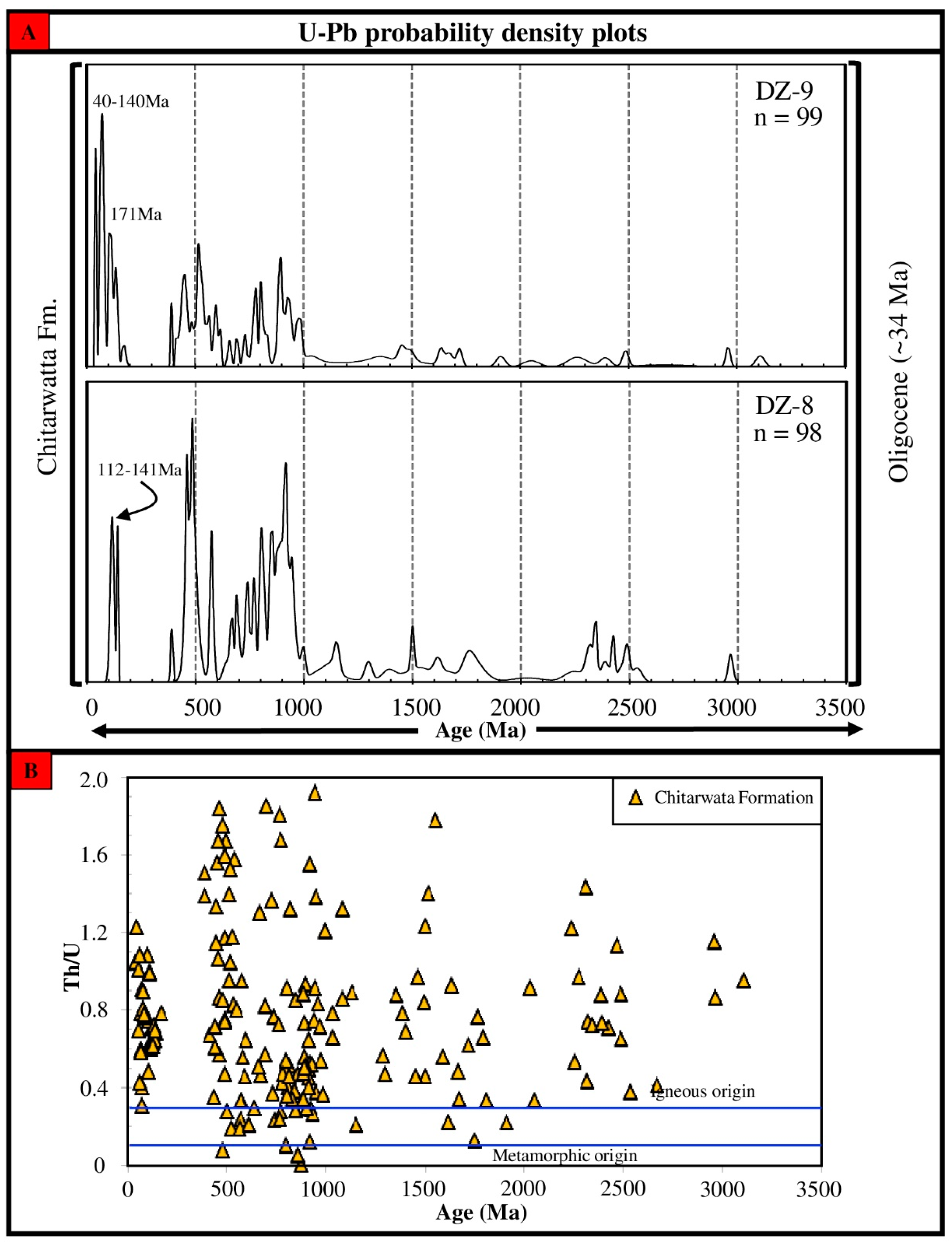
5. U–Pb Geochronology Results

Chitarwatta Formation (Age~34 Ma)

The sample DZ-8 was collected from the lower contact zone (Figure 2). One hundred detrital zircons were analyzed, which yielded 98 usable concordant ages. The PDP shows that the major population (~70%) is clustered between ~391 Ma and ~1150 Ma. The peak ages in this range are present at ~459 Ma, ~485 Ma, ~574 Ma, ~688 Ma, ~741 Ma, ~803 Ma, ~856 Ma, and ~918 Ma (Figure 5A). A minor age cluster (~12%) is present between the ages ~1498 Ma and ~1808 Ma, with peaks at ~1500 Ma and ~1775 Ma (Figure 5A). Another minor population of ages exists between ~2237 Ma and ~2535 Ma. A few zircons yielded younger ages, in a range between ~110 Ma and 130 Ma (Figure 5).
The sample DZ-9 is representative of the upper portion of the Chitarwatta Formation. One hundred analyses yielded 93 concordant ages. A significant younger age cluster (~30%) exists between the ages ~40 Ma and ~170 Ma, with age peaks at ~60 Ma, ~63 Ma, and ~83 Ma (Figure 5A). The major cluster (~57%) is present between the ages ~390 Ma and ~1100 Ma (Figure 5A). A minor age population exists between the ages ~1285 Ma and ~1720 Ma (Figure 5A). In addition, a few scattered ages exist between ~1900 Ma and ~3100 Ma (Figure 5A).

6. Internal Zoning Pattern and Th/U Ratio

Different patterns of zoning obtained through CL imaging show the origin of zircons to be either metamorphic, igneous or sedimentary [17,43,45]. The grain sizes obtained from the collected samples were in between the range of ~50–150 micrometer. These grains were separated from medium-coarse grained samples of sandstone. The zircons of igneous source mostly showed oscillatory zoning. While the grains showing a metamorphic origin had a younger rim with core. A few zircons with xenocryst cores, with sectoral zoning, without a zoning pattern, and showing a plane texture were also seen.
The ratio of Th/U obtained from the analysis was used to distinguish the origin as being metamorphic or igneous [13,46]. The ratio of zircon representing a metamorphic origin is usually less than 0.3, while it is greater than 0.3 for igneous grains [46].
In this study, the binary plot of the detrital ages and Th/U ratio reflects that the major age population, between ~500 Ma and ~1200 Ma, has mixed igneous and metamorphic origins (Figure 5B). This mixed source likely reflects derivation from the igneous and metamorphic rocks widely exposed in the Indian craton. This event is mostly associated with the Pan-African orogeny, which has been identified well in the northwestern Himalayas [11]. Similarly, the early Proterozoic–Archean (~1300–3500 Ma) zircons predominantly reflect an igneous origin, with very few metamorphic origin zircons. Early Proterozoic–Archean age granites are common in the Indian craton and higher and lesser Himalayan zones, which might have been possibly reworked and deposited on the northern margin. These detrital zircons, with ages between Archean and Paleozoic, were most likely derived from the Higher Himalayan zone. However, the significant younger zircons, with ages <100 Ma, are completely consistent with an igneous origin (Figure 5B). This younger age population is representative of the Kohistan–Ladakh arc, marking the onset of the India–Asia collision.

7. Discussion

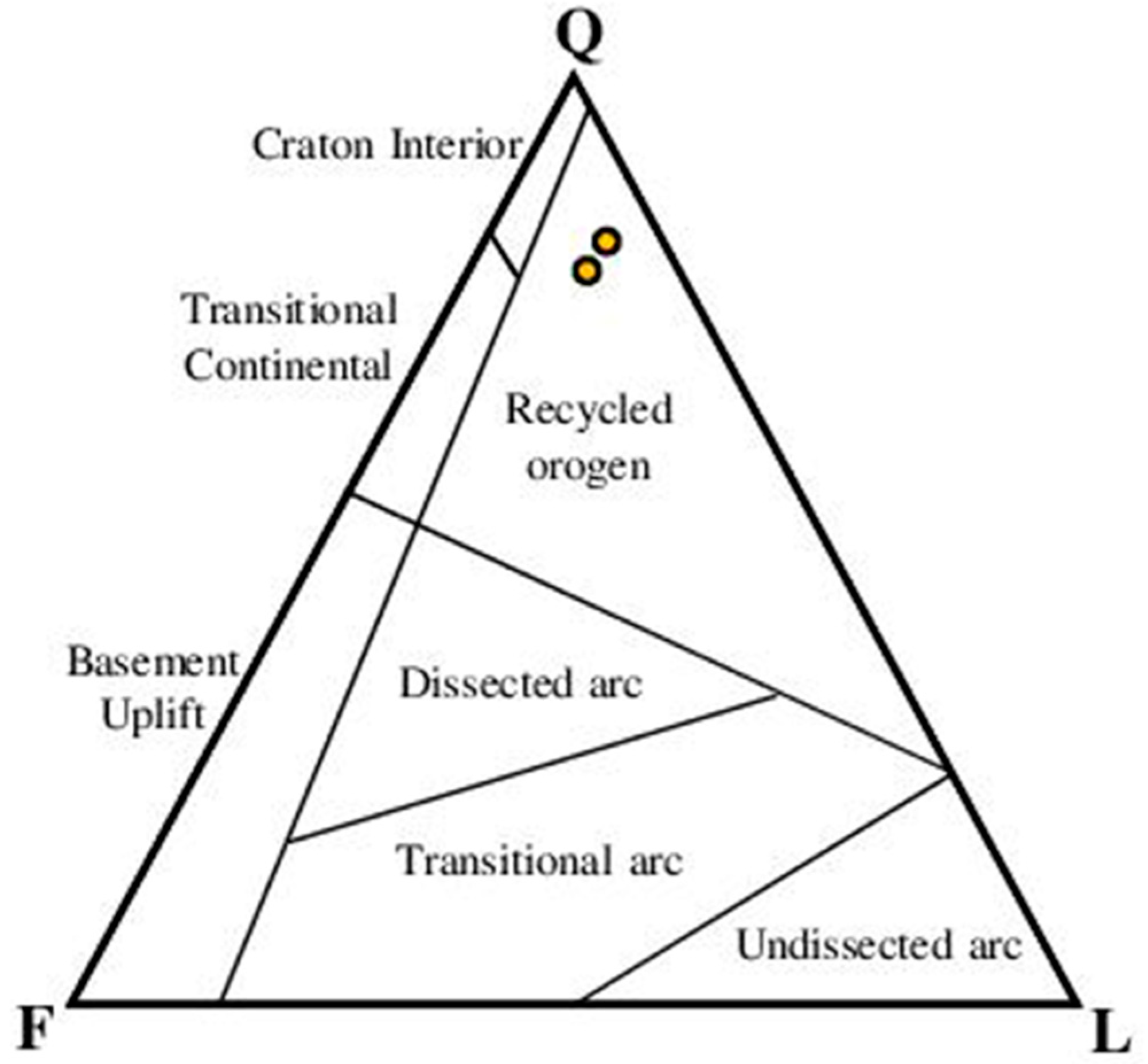
7.1. Ages of the Source Terranes

The sediments of the Chitarwatta Formation exposed in the Mughalkot section, could have been sourced from either Asian or Indian terrain. We have combined their distinguishing ages together for a better comparison and interpretation. The Asian sources includes the Karakoram block (KB), Lhasa block (LB), and Kohistan–Ladakh Arc (KLA), whereas, the Indian/Himalayan source consists of the Lesser Himalaya (LH), Greater Himalaya (GH)/Higher Himalaya (HH), and Tethyan Himalaya (TH) [4,47,48]. The detrital zircons from the Asian source are mostly younger, having a distinctive age pattern ranging from ~20 to ~120 Ma, representing the plutons related to the magmatic process of collision. If they are observed in the detritus, it would indicate their involvement in the tectonic evolution. On the other hand, the Himalayan terrane-sourced sediments also have zircons with a distinct age pattern. For the LH, the age clusters are in the range of ~1700 to 1900 Ma, with a minor group of ~2400–2600 Ma. In HH, the age cluster is observable in between ~900 and 1100 Ma, with minors at ~540–750 Ma, ~800–1200 Ma, ~1600–1900 Ma, and~2400–2600 Ma [3,47]. The age cluster of zircons of TH has a similar pattern to HH except the prominent cluster of ~480 to 570 Ma, as compared to the less prominent ones at ~2430 to 2560 Ma and ~700–1200 Ma. There is also the presence of younger ages from volcanics of India, in the age range of ~110 Ma and ~140 Ma [3,20,49,50].

7.2. Detrital Zircon Provenance of Chitarwatta Formation

The composite PDP of the U–Pb ages of the Chitarwatta Formation shows that the major age clusters are around ~390–1150 Ma, ~1200–1800 Ma, and ~2237–2535 Ma (Figure 6). The age cluster ~390–1100 Ma matches well with the TH age pattern, whereas the ~1200–1800 Ma and ~2237–2535 Ma match with the LH and HH age patterns, respectively. Furthermore, the younger age cluster (~40–170 Ma) is representative of Eurasian sources (Figure 6). However, the few younger ages, between ~120–170 Ma, match with the TH volcanic rocks and the ophiolitic sources [51].
The younger age pattern, with detrital ages between ~60 Ma and ~90 Ma, are representative of the Kohistan–Ladakh arc. This younger pattern suggests an increased input from Eurasian sources. However, the major population yielded Proterozoic to Cambrian ages, which is ~70% of the total ages. This suggests an increased input from the Higher Himalaya, where Proterozoic–Cambrian granites are widely exposed [3,47]. In addition, the Sr–Nd isotopic data of the Chitarwatta Formation yielded values that resembled the Higher Himalaya [56]. In addition, metamorphic minerals were observed in the sediments of the Chitarwatta Formation, which indicates derivation from the metamorphic rocks of the Higher Himalaya [56]. The Th/U ratio and internal zoning pattern also suggested mainly derivation from igneous sources that are closed exposed in the Higher Himalaya. The detritus of the Chitarwatta Formation evidenced post-collisional (India–Asia) sources [26]. Considering this evidence and our detrital zircon U–Pb age dataset, it can be suggested that during the deposition of the Chitarwatta Formation, the Indus drainage system fed the basin in the Sulaiman fold–thrust belt (Figure 7A,B). The inputs of the Higher Himalayan source suggest the uplifting of the Higher Himalaya since the Oligocene.
The detrital record of the Chitarwatta Formation is compared with the coeval Murree Formation (Hazara–Kashmir syntaxial region), Dagshai Formation (India), Dumre Formation (Nepal), and Barail Formation (Bengal Basin) [1,8,11,54,55]. The coeval Murree Formation and Dagshai Formation (Subathu Basin) are exposed in the western Himalaya, the Dumre Formation represents the central Himalaya, and the Barail Formation represents the eastern Himalaya. The detrital record shows strong similarity to the Murree, Dagshai and Barail formations, whereas the detrital record of the Dumre Formation shows comparatively less similarity. This suggests that the major drainage system developed towards the west and east, while the central segment of the Himalaya was uplifted and did not receive the detritus.

7.3. Implications for Exhumation

Up-section, the deposition of the Kirthar group and Chitarwatta Formation occurred during the Eocene–Oligocene, in a marine environment [5], which later changed to a continental environment during the Miocene–Pliocene Siwaliks deposition [57]. The Oligocene Chitarwatta Formation has a major increase in input of detrital grains from the younger source (< 120 Ma) of KLA and KB of the Eurasian plate. This indicates increased erosion from the collided block. The collision in the SFB has been reported in earlier studies to be at ~50 Ma [26], based on the integrated isotopic and detrital zircon U–Pb studies. The earlier sediments, including the Ghazij Formation are considered to have a pre-collisional detrital source, while the post-collisional detritus has been reported to be from the Kirthar and Chitarwatta formations [26,56]. Our data also indicate a similar post collisional provenance for the Chitarwatta Formation (Figure 7A,B). This provenance explains the exhumation of the Himalayan litho-tectonic terranes in response to the continuous India–Asia collision. Initially, following the collision, the foreland basin developed in the footwall of the Indus suture zone. This foreland basin received detritus from the KB, KLA, and ophiolitic sources. This detritus was deposited in the form of the Ghazij, Subathu, and Amile formations [26,58]. As the collision continued, the fold–thrust belt propagated southward, and another fault (MCT), south of the Indus suture zone, was activated, which caused uplifting of the Higher Himalayan block (Figure 7B). With this uplifting, the central part of the Himalaya attained a higher elevation, causing the development of the two major drainage systems that feed the foreland basin to the west and east. These drainage systems are the Indus drainage system and the Bengal drainage system. The Indus drainage system delivered the detritus from the uplifted Higher Himalayan block to the western part of the foreland basin, in the form of deposition of the Chitarwatta Formation and its coeval units (Murree Formation, Dagshai Formation, and Dumre Formation) (Figure 7B). Similarly, the Barail Formation received detritus through the Bengal drainage system, which shows strongly similar detritus [55]. The coeval Dumre Formation detrital age spectrum shows its deposition in the distal part of the basin, which is comparatively far from the major drainage system. Following the model of Ding, et al. [59], the India–Eurasia collision occurred in the central segment that uplifted the central part earlier than the west and east. The Indian margin gradually closed towards the west and east, with the development of the Indus drainage system in the west and Bengal drainage system towards the east. The detrital record suggests that the Higher Himalaya were exhumed during the Oligocene–Miocene, and provided the Higher Himalayan detritus to the Chitarwatta Formation through the Indus drainage system. The strong similarity of the detrital record with the coeval Barail Formation (eastern Himalaya) suggests a similar source, which is delivered through the Bengal drainage system, developed to the east during the Oligocene–Miocene time.

8. Conclusions

This study calls on the post-collisional process of the India–Asia collision and explains the possible exhumation of the litho-tectonic terranes present south of the Indus suture zone. The detrital record of the Chitarwatta Formation suggests that the detritus is mainly derived from post-collisional sources, including the Higher Himalaya, with contributions from TH. In addition, the younger detrital zircon ages suggest the contribution of Eurasian sources, including the Kohistan–Ladakh arc and Karkoram block. The Th/U ratios of the detrital zircons suggest that the major source of the zircons were igneous rocks. Granitic rocks aged 400–1100 Ma are widely exposed in the HH, which is the nearest possible source for the foreland basin sediments after the collision. Thus, comparing the detrital record of the Chitarwatta Formation and its coeval units, we propose that the sediment detritus is mainly delivered from the northern provenance (as reflected by the U–Pb detrital ages) including KLA, KB, and the HH. The detritus from this source is mainly delivered by the same drainage system that fed the coeval units, which is likely the Indus drainage system. The HH detritus, as a post-collisional source, suggests the uplifting of the HH block during the Oligocene–Miocene.

Author Contributions

Conceptualization, M.Q. and L.D.; methodology, software, validation and formal analysis, O.T. and J.A.; investigation, M.Q.; resources, L.D.; data curation, O.T.; Writing—original draft preparation, M.Q. and O.T.; Writing—review & editing, J.I.T., Z.I.B., M.U., H.K. and I.A.K.J.; visualization, M.Q.; supervision, M.Q. and L.D.; project administration, M.Q. and L.D.; Funding acquisition, L.D. All authors have read and agreed to the published version of the manuscript.

Funding

This work was financially supported by the Second Tibetan Plateau Scientific Expedition and Research Program (STEP; Grant No. 2019QZKK0708), NRPU research grant (20-14573/NRPU/R&D/HEC/20212021), the Strategic Priority Research Program of the Chinese Academy of Sciences (XDA20070301), the National Natural Science Foundation of China BSCTPES project (Grant No. 41988101) and International Partnership Program of Chinese Academy of Sciences (131551KYSB20200021).

Institutional Review Board Statement

Not applicable.

Informed Consent Statement

Not applicable.

Data Availability Statement

Data can be provided on request.

Acknowledgments

This is part of the PIFI postdoc research and MS thesis at the Department of Earth Sciences, CUI, Abbottabad Campus, Pakistan.

Conflicts of Interest

The authors declare no conflict of interest.

References

  1. Ding, L.; Qasim, M.; Jadoon, I.A.; Khan, M.A.; Xu, Q.; Cai, F.; Wang, H.; Baral, U.; Yue, Y. The India–Asia collision in north Pakistan: Insight from the U–Pb detrital zircon provenance of Cenozoic foreland basin. Earth Planet. Sci. Lett. 2016, 455, 49–61. [Google Scholar] [CrossRef] [Green Version]
  2. DeCelles, P.G.; Giles, K.A. Foreland basin systems. Basin Res. 1996, 8, 105–123. [Google Scholar] [CrossRef]
  3. DeCelles, P.; Kapp, P.; Gehrels, G.; Ding, L. Paleocene-Eocene foreland basin evolution in the Himalaya of southern Tibet and Nepal: Implications for the age of initial India-Asia collision. Tectonics 2014, 33, 824–849. [Google Scholar] [CrossRef]
  4. Najman, Y. The detrital record of orogenesis: A review of approaches and techniques used in the Himalayan sedimentary basins. Earth-Sci. Rev. 2006, 74, 1–72. [Google Scholar] [CrossRef]
  5. Khan, I.H.; Clyde, W.C. Lower Paleogene Tectonostratigraphy of Balochistan: Evidence for Time-Transgressive Late Paleocene-Early Eocene Uplift. Geosciences 2013, 3, 466–501. [Google Scholar] [CrossRef] [Green Version]
  6. Myrow, P.; Hughes, N.; Paulsen, T.; Williams, I.; Parcha, S.; Thompson, K.; Bowring, S.; Peng, S.-C.; Ahluwalia, A. Integrated tectonostratigraphic analysis of the Himalaya and implications for its tectonic reconstruction. Earth Planet. Sci. Lett. 2003, 212, 433–441. [Google Scholar] [CrossRef]
  7. Najman, Y.; Garzanti, E.; Pringle, M.; Bickle, M.; Stix, J.; Khan, I. Early-Middle Miocene paleodrainage and tectonics in the Pakistan Himalaya. Geol. Soc. Am. Bull. 2003, 115, 1265–1277. [Google Scholar] [CrossRef] [Green Version]
  8. Awais, M.; Qasim, M.; Tanoli, J.I.; Ding, L.; Sattar, M.; Baig, M.S.; Pervaiz, S. Detrital Zircon Provenance of the Cenozoic Sequence, Kotli, Northwestern Himalaya, Pakistan; Implications for India–Asia Collision. Minerals 2021, 11, 1399. [Google Scholar] [CrossRef]
  9. Qasim, M.; Ahmad, J.; Ding, L.; Tanoli, J.I.; Sattar, M.; Rehman, Q.U.; Awais, M.; Umar, M.; Baral, U.; Khan, H. Integrated provenance and tectonic implications of the Cretaceous–Palaeocene clastic sequence, Changla Gali, Lesser Himalaya, Pakistan. Geol. J. 2021, 56, 4747–4759. [Google Scholar] [CrossRef]
  10. Qasim, M.; Ding, L.; Khan, M.A.; Baral, U.; Jadoon, I.A.; Umar, M.; Imran, M. Provenance of the Hangu Formation, Lesser Himalaya, Pakistan: Insight from the detrital zircon U-Pb dating and spinel geochemistry. Palaeoworld 2020, 29, 729–743. [Google Scholar] [CrossRef]
  11. Qasim, M.; Ding, L.; Khan, M.A.; Jadoon, I.A.; Haneef, M.; Baral, U.; Cai, F.; Wang, H.; Yue, Y. Tectonic implications of detrital zircon ages from lesser Himalayan Mesozoic-Cenozoic strata, Pakistan. Geochem. Geophys. Geosystems 2018, 19, 1636–1659. [Google Scholar] [CrossRef]
  12. Chen, Y.; Ding, L.; Li, Z.; Laskowski, A.K.; Li, J.; Baral, U.; Qasim, M.; Yue, Y. Provenance analysis of Cretaceous peripheral foreland basin in central Tibet: Implications to precise timing on the initial Lhasa-Qiangtang collision. Tectonophysics 2020, 775, 228311. [Google Scholar] [CrossRef]
  13. Armstrong-Altrin, J.S. Detrital zircon U–Pb geochronology and geochemistry of the Riachuelos and Palma Sola beach sediments, Veracruz State, Gulf of Mexico: A new insight on palaeoenvironment. J. Palaeogeogr. 2020, 9, 28. [Google Scholar] [CrossRef]
  14. Armstrong-Altrin, J.S.; Lee, Y.I.; Kasper-Zubillaga, J.J.; Carranza-Edwards, A.; Garcia, D.; Eby, G.N.; Balaram, V.; Cruz-Ortiz, N.L. Geochemistry of beach sands along the western Gulf of Mexico, Mexico: Implication for provenance. Geochemistry 2012, 72, 345–362. [Google Scholar] [CrossRef]
  15. Armstrong-Altrin, J.S.; Ramos-Vázquez, M.A.; Hermenegildo-Ruiz, N.Y.; Madhavaraju, J. Microtexture and U–Pb geochronology of detrital zircon grains in the Chachalacas beach, Veracruz State, Gulf of Mexico. Geol. J. 2021, 56, 2418–2438. [Google Scholar] [CrossRef]
  16. Fornelli, A.; Festa, V.; Micheletti, F.; Spiess, R.; Tursi, F. Building an Orogen: Review of U-Pb Zircon Ages from the Calabria–Peloritani Terrane to Constrain the Timing of the Southern Variscan Belt. Minerals 2020, 10, 944. [Google Scholar] [CrossRef]
  17. Fornelli, A.; Gallicchio, S.; Micheletti, F.; Langone, A. U–Pb detrital zircon ages from Gorgoglione Flysch sandstones in Southern Apennines (Italy) as provenance indicators. Geol. Mag. 2021, 158, 859–874. [Google Scholar] [CrossRef]
  18. Dew, R.E.; Collins, A.S.; Morley, C.K.; King, R.C.; Evans, N.J.; Glorie, S. Coupled detrital zircon U–Pb and Hf analysis of the Sibumasu Terrane: From Gondwana to northwest Thailand. J. Asian Earth Sci. 2021, 211, 104709. [Google Scholar] [CrossRef]
  19. Baral, U.; Lin, D.; Chamlagain, D. Detrital zircon U–Pb geochronology of the Siwalik Group of the Nepal Himalaya: Implications for provenance analysis. Int. J. Earth Sci. 2016, 105, 921–939. [Google Scholar] [CrossRef]
  20. DeCelles, P.; Gehrels, G.; Najman, Y.; Martin, A.; Carter, A.; Garzanti, E. Detrital geochronology and geochemistry of Cretaceous–Early Miocene strata of Nepal: Implications for timing and diachroneity of initial Himalayan orogenesis. Earth Planet. Sci. Lett. 2004, 227, 313–330. [Google Scholar] [CrossRef]
  21. Nazeer, A.; Solangi, S.H.; Brohi, I.A.; Usmani, P.; Napar, L.D.; Jahangir, M.; Hameed, S.; Ali, S.M. Hydrocarbon Potential Of Zinda Pir Anticline, Eastern Sulaiman Fold Belt, Middle Indus Basin, Pakistan. Pakista J. Hydrocarb. Res. 2013, 23, 73–84. [Google Scholar]
  22. Jadoon, I.; Zaib, M. Tectonic Map of Sulaiman Fold Belt: 1:500,000 Scale. In COMSATS; University Islamabad: Abbottabad, Pakistan, 2018. [Google Scholar]
  23. Ahmad, N. Palaeoenvironments, Diagenesis, and Geochemical Studies of the Dungan Formation (Palaeocene), Eastern Sulaiman Range, Pakistan; University of Leicester: Leicester, UK, 1996. [Google Scholar]
  24. Özcan, E.; Ali, N.; Hanif, M.; Hashmi, S.I.; Khan, A.; Yücel, A.O.; Abbasi, İ.A. A new Priabonian Heterostegina from the Eastern Tethys (Sulaiman Fold Belt, West Pakistan): Implications for the development of Eastern Tethyan heterostegines and their paleobiogeography. J. Foraminifer. Res. 2016, 46, 393–408. [Google Scholar] [CrossRef]
  25. Jadoon, I.A.; Lawrence, R.D.; Lillie3, R.J. Seismic data, geometry, evolution, and shortening in the active Sulaiman fold-and-thrust belt of Pakistan, southwest of the Himalayas. AAPG Bull. 1994, 78, 758–774. [Google Scholar]
  26. Zhuang, G.; Najman, Y.; Guillot, S.; Roddaz, M.; Antoine, P.-O.; Métais, G.; Carter, A.; Marivaux, L.; Solangi, S.H. Constraints on the collision and the pre-collision tectonic configuration between India and Asia from detrital geochronology, thermochronology, and geochemistry studies in the lower Indus basin, Pakistan. Earth Planet. Sci. Lett. 2015, 432, 363–373. [Google Scholar] [CrossRef]
  27. Jagoutz, O.; Schmidt, M.W. The formation and bulk composition of modern juvenile continental crust: The Kohistan arc. Chem. Geol. 2012, 298, 79–96. [Google Scholar] [CrossRef]
  28. Schelling, D.D. Frontal structural geometries and detachment tectonics of the. Himalaya Tibet. Mt. Roots Mt. Tops 1999, 328, 287. [Google Scholar]
  29. Klootwijk, C.; Conaghan, P.; Powell, C.M. The Himalayan Arc: Large-scale continental subduction, oroclinal bending and back-arc spreading. Earth Planet. Sci. Lett. 1985, 75, 167–183. [Google Scholar] [CrossRef]
  30. Saif-Ur-Rehman, K.J.; Ding, L.; Jadoon, I.A.; Baral, U.; Qasim, M.; Idrees, M. Interpretation of the Eastern Sulaiman fold-and-thrust belt, Pakistan: A passive roof duplex. J. Struct. Geol. 2019, 126, 231–244. [Google Scholar]
  31. Jadoon, I.A.; Khurshid, A. Gravity and tectonic model across the Sulaiman fold belt and the Chaman fault zone in western Pakistan and eastern Afghanistan. Tectonophysics 1996, 254, 89–109. [Google Scholar] [CrossRef]
  32. Lawrence, R.; Yeats, R.; Khan, S.; Farah, A.; DeJong, K. Thrust and strike slip fault interaction along the Chaman transform zone, Pakistan. Geol. Soc. Lond. Spec. Publ. 1981, 9, 363–370. [Google Scholar] [CrossRef]
  33. Jadoon, I.A.K. Thin-Skinned Tectonics on Continent/Ocean Transitional Crust, Sulaiman Range, Pakistan. Ph.D. Thesis, Oregon State University, Corvallis, OR, USA, 1991. [Google Scholar]
  34. Sarwar, G. Arcs, oroclines, syntaxis, the curvatures of mountain belts in Pakistan. Geodyn. Pak. 1979, 341–349. [Google Scholar]
  35. Gnos, E.; Immenhauser, A.; Peters, T. Late Cretaceous/early Tertiary convergence between the Indian and Arabian plates recorded in ophiolites and related sediments. Tectonophysics 1997, 271, 1–19. [Google Scholar] [CrossRef]
  36. Allemann, F. Time of emplacement of the Zhob Valley ophiolites and Bela ophiolites, Baluchistan (preliminary report). In Geodynamics of Pakistan; Geological Survey of Pakistan: Quetta, Pakistan, 1979; pp. 215–242. [Google Scholar]
  37. Iqbal, M.; Khan, M.R. Impact of Indo-Pakistan and Eurasian Plates Collision in the Sulaiman Fold Belt, Pakistan; Search and Discovery Article 50575; Datapage Inc.: Arleta, CA, USA, 2012. [Google Scholar]
  38. Humayon, M.; Lillie, R.J.; Lawrence, R.D. Structural interpretation of the eastern Sulaiman foldbelt and foredeep, Pakistan. Tectonics 1991, 10, 299–324. [Google Scholar] [CrossRef]
  39. Iqbal, M.; Helmcke, D. Geological interpretation of earthquakes data of Zindapir Anticlinorium, Sulaiman foldbelt, Pakistan. Pak. J. Hydrocarb. Res. 2004, 14, 41–47. [Google Scholar]
  40. Peresson, H.; Daud, F. Integrating Structural Geology and GIS: Wrench tectonics and exploration potential in the eastern Sulaiman fold belt. In Proceedings of the Pakistan Association of Petroleum Geoscientists (PAPG)/Society of Petroleum Engineers (SPE), Annual Technical Conference, Islamabad, Pakistan, 17–18 November 2009. [Google Scholar]
  41. Raza, H.A.; Ahmed, R.; Ali, S.M.; Ahmad, J. Petroleum prospects: Sulaiman sub-basin, Pakistan. Pak. J. Hydrocarb. Res. 1989, 1, 21–56. [Google Scholar]
  42. Dickinson, W.R. Interpreting provenance relations from detrital modes of sandstones. In Provenance of Arenites; Springer: Berlin/Heidelberg, Germany, 1985; pp. 333–361. [Google Scholar]
  43. Corfu, F.; Hanchar, J.M.; Hoskin, P.W.; Kinny, P. Atlas of zircon textures. Rev. Mineral. Geochem. 2003, 53, 469–500. [Google Scholar] [CrossRef]
  44. Sláma, J.; Košler, J.; Condon, D.J.; Crowley, J.L.; Gerdes, A.; Hanchar, J.M.; Horstwood, M.S.; Morris, G.A.; Nasdala, L.; Norberg, N. Plešovice zircon—A new natural reference material for U–Pb and Hf isotopic microanalysis. Chem. Geol. 2008, 249, 1–35. [Google Scholar] [CrossRef]
  45. Rubatto, D. Zircon: The metamorphic mineral. Rev. Mineral. Geochem. 2017, 83, 261–295. [Google Scholar] [CrossRef]
  46. Rubatto, D. Zircon trace element geochemistry: Partitioning with garnet and the link between U–Pb ages and metamorphism. Chem. Geol. 2002, 184, 123–138. [Google Scholar] [CrossRef]
  47. Gehrels, G.; Kapp, P.; DeCelles, P.; Pullen, A.; Blakey, R.; Weislogel, A.; Ding, L.; Guynn, J.; Martin, A.; McQuarrie, N. Detrital zircon geochronology of pre-Tertiary strata in the Tibetan-Himalayan orogen. Tectonics 2011, 30. [Google Scholar] [CrossRef]
  48. Ravikant, V.; Wu, F.-Y.; Ji, W.-Q. U–Pb age and Hf isotopic constraints of detrital zircons from the Himalayan foreland Subathu sub-basin on the Tertiary palaeogeography of the Himalaya. Earth Planet. Sci. Lett. 2011, 304, 356–368. [Google Scholar] [CrossRef]
  49. Cai, F.; Ding, L.; Yue, Y. Provenance analysis of upper Cretaceous strata in the Tethys Himalaya, southern Tibet: Implications for timing of India–Asia collision. Earth Planet. Sci. Lett. 2011, 305, 195–206. [Google Scholar]
  50. Hu, X.; Wang, J.; BouDagher-Fadel, M.; Garzanti, E.; An, W. New insights into the timing of the India–Asia collision from the Paleogene Quxia and Jialazi formations of the Xigaze forearc basin, South Tibet. Gondwana Res. 2016, 32, 76–92. [Google Scholar] [CrossRef]
  51. Qasim, M.; Tanoli, J.I.; Ahmad, L.; Ding, L.; Rehman, Q.U.; Umber, U. First U-Pb Detrital Zircon Ages from Kamlial Formation (Kashmir, Pakistan): Tectonic Implications for Himalayan Exhumation. Minerals 2022, 12, 298. [Google Scholar] [CrossRef]
  52. Ji, W.-Q.; Wu, F.-Y.; Chung, S.-L.; Li, J.-X.; Liu, C.-Z. Zircon U–Pb geochronology and Hf isotopic constraints on petrogenesis of the Gangdese batholith, southern Tibet. Chem. Geol. 2009, 262, 229–245. [Google Scholar] [CrossRef]
  53. Ravikant, V.; Wu, F.-Y.; Ji, W.-Q. Zircon U–Pb and Hf isotopic constraints on petrogenesis of the Cretaceous–Tertiary granites in eastern Karakoram and Ladakh, India. Lithos 2009, 110, 153–166. [Google Scholar] [CrossRef]
  54. Colleps, C.L.; McKenzie, N.R.; Horton, B.K.; Webb, A.A.G.; Ng, Y.W.; Singh, B.P. Sediment provenance of pre- and post-collisional Cretaceous–Paleogene strata from the frontal Himalaya of northwest India. Earth Planet. Sci. Lett. 2020, 534, 116079. [Google Scholar] [CrossRef]
  55. Najman, Y.; Bickle, M.; BouDagher-Fadel, M.; Carter, A.; Garzanti, E.; Paul, M.; Wijbrans, J.; Willett, E.; Oliver, G.; Parrish, R.; et al. The Paleogene record of Himalayan erosion: Bengal Basin, Bangladesh. Earth Planet. Sci. Lett. 2008, 273, 1–14. [Google Scholar] [CrossRef]
  56. Roddaz, M.; Said, A.; Guillot, S.; Antoine, P.-O.; Montel, J.-M.; Martin, F.; Darrozes, J. Provenance of Cenozoic sedimentary rocks from the Sulaiman fold and thrust belt, Pakistan: Implications for the palaeogeography of the Indus drainage system. J. Geol. Soc. 2011, 168, 499–516. [Google Scholar] [CrossRef]
  57. Shah, S.I. Stratigraphy of Pakistan; Government of Pakistan Ministry of Petroleum & Natural Resorces Geological Survey of Pakistan: Islamabad, Pakistan, 2009.
  58. Sabins, F.F. Remote sensing for mineral exploration. Ore Geol. Rev. 1999, 14, 157–183. [Google Scholar] [CrossRef]
  59. Ding, L.; Kapp, P.; Wan, X. Paleocene-Eocene record of ophiolite obduction and initial India-Asia collision, south central Tibet. Tectonics 2005, 24. [Google Scholar] [CrossRef] [Green Version]
Figure 1. (A) Simplified map showing regional tectonic features. The blue rectangle shows the location of the Sulaiman fold–thrust belt (SFB), and the red rectangle shows the Hazara–Kashmir syntaxial bend (after [11]). (B) The simplified geological map of SFB, showing the location of the studied section (after [21]). (C) Geological map of the study area, showing major geological units [22]. The solid black line represents the location of the Mughalkot section.
Applsci 13 03418 g001
Figure 2. Generalized lithostratigraphic column of the Mughalkot section, Sulaiman fold–thrust belt showing lithologies of the various stratigraphic units and stratigraphic position of the collected samples [21].
Applsci 13 03418 g002
Figure 3. (A,B) Field photographs showing sandstone and shales of the Chitarwatta Formation. (C,D) Photomicrographs of the sandstone of the Chitarwatta Formation, showing major framework grains and accessory minerals. Where, Qm—monocrystalline quartz, Qp—polycrystalline quartz, AF—alkali feldspar, PF—plagioclase feldspar, L—lithics, Ep—epidote, and T—tourmaline.
Applsci 13 03418 g003
Figure 4. Ternary diagram showing tectonic discrimination of the studied sandstone samples [42]. Where Q—total quartz, F—feldspar, and L—lithics.
Applsci 13 03418 g004
Figure 5. (A) Probability density plots of the U–Pb ages of detrital zircon samples representing the Cenozoic sequence, Mughalkot section, Sulaiman fold–thrust belt. (B) The binary plot showing the U–Pb detrital zircon ages and Th/U ratio, reflecting igneous and metamorphic zircons.
Applsci 13 03418 g005
Figure 6. Comparison of the composite PDPs of the studied detrital zircon samples with the adjacent source regions [3,47,52,53], and coeval sedimentary units exposed along the strike [8,54,55]. Where TH—Tethyan Himalaya, HH—Higher Himalaya, LH—Lesser Himalaya, KB—Karakoram block, LB—Lhasa block, and KLA—Kohistan–Ladakh arc.
Applsci 13 03418 g006
Figure 7. Tectonic model showing the paleogeographic reconstruction of the Indian plate (modified after [56]. (A) The Indian margin received detritus from Eurasian sources and ophiolitic sources exposed in the collision zone, 50–30 Ma. (B) When the deposition of the Chitarwatta Formation and its coeval units (Murree, Dagshai, Dumre, and Barail Formations) occurred in the foreland basin and exhumation of the Higher Himalaya occurred, 30–20 Ma.
Applsci 13 03418 g007
Table 1. Petrographic data of studied samples and percentage compositions of the framework grains. Where, Qm—monocrystalline quartz, Qp—quartz polycrystalline, Pf—plagioclase feldspar, Af—alkali feldspar, F—total feldspar, Ls—sedimentary lithics, Lm—metamorphic lithics, Li—igneous lithics, L—total lithics, and Q—total quartz.
Formation NameSample No.QuartzFeldsparLithicsMatrix/CementAccessory MineralsBioclastPercentage Composition Framework Grains
QmQpQPfAfFLsLmLiClayCalciteEpidoteTourmaline Q F L Qm F L
Chitarwata FormationDZ-8319-3191242545--3%10%38- 82 6 12 82 6 12
DZ-931513161464735--3%15%11- 79 12 9 79 12 9
Table 2. The petrographic properties of the grains observed in thin sections.
Formation NameSample No.Grain ShapeFabric Support/ContactsSortingMaturity
RoundnessSphericityTextural Mineralogical
Chitarwata FormationDZ-8Sub angular-Sub roundedLow-MediumGrain supported, Planar-Pointed contactsWell sortedMatureMature
DZ-9Sub angular-Sub roundedLow-MediumGrain supported, Planar-Pointed contactsWell sortedMatureMature
Disclaimer/Publisher’s Note: The statements, opinions and data contained in all publications are solely those of the individual author(s) and contributor(s) and not of MDPI and/or the editor(s). MDPI and/or the editor(s) disclaim responsibility for any injury to people or property resulting from any ideas, methods, instructions or products referred to in the content.

