
A Systematic Literature Review on Urban Resilience Enabled with Asset and Disaster Risk Management Approaches and GIS-Based Decision Support Tools


Abstract
Featured Application
Abstract
1. Introduction
2. Background Knowledge
2.1. Asset and Disaster Risk Management
2.2. Resilience and Sustainability of Urban Infrastructure and Buildings
2.3. Decision Science Support Mechanism and/or Tools
3. Methodology
3.1. Rationale
3.2. Protocol and Registration
3.3. Eligibility Criteria
3.4. Information Sources
3.5. Search
3.6. Study Selection
3.7. Data Collection Process
3.8. Risk of Bias
4. Bibliometric Analysis Results
4.1. Natural Language Processing of the Word Trend
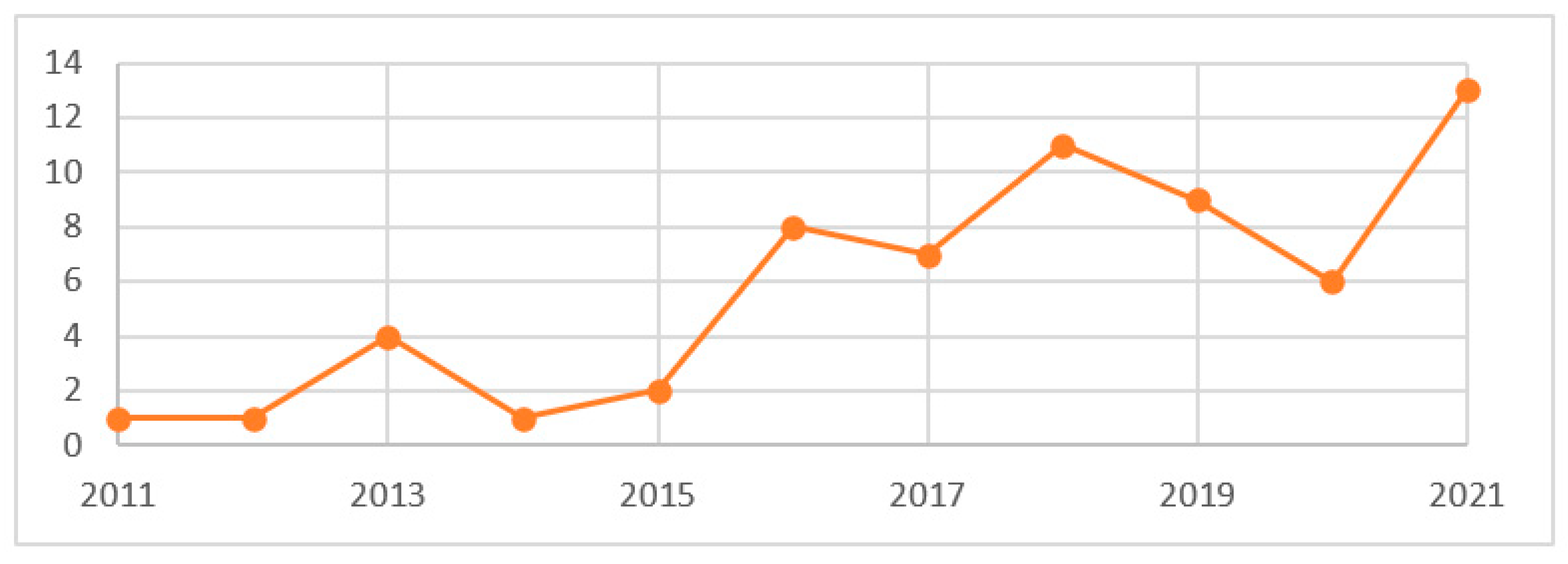
4.2. Annual Publications
4.3. Subject Areas and Resource Type
5. Discussion
5.1. Major Areas of Discussion in UR Publications
5.1.1. Climate Change
5.1.2. Disaster Risk Assessment and Treatment
5.1.3. Geographic Information System (GIS)
5.1.4. Urban and Transportation Infrastructure
5.1.5. Decision Making and Disaster Management
5.1.6. Community and Disaster Resilience
5.1.7. Green Infrastructure and Sustainable Development
5.2. Knowledge Gaps and Future Study Opportunities on UR and Decision Science
5.2.1. Resilience Definition and Multidisciplinary Analysis
5.2.2. Unified Scalable and Adoptable UR Model
5.2.3. Geographic Information System (GIS) UR Multidimensional Tools
5.2.4. Stochastic Analysis of Virtual Cities
5.2.5. Scenario-Based Decision Making Mechanism for UR
6. Conclusions
Author Contributions
Funding
Institutional Review Board Statement
Conflicts of Interest
Appendix A

| Title | Reference | Research GAP/Motivation | Objective/Purpose | Result/Output |
|---|---|---|---|---|
| Network-based Assessment of Metro Infrastructure with a Spatial–temporal Resilience Cycle Framework | [133] | The topology of the network was emphasized in current network-based resilience assessment methods, but the effects of flow pattern temporal fluctuation and system geographic distribution, which offer unique human-centered insights into resilience, were seldom considered. | utilized a framework for resilience that consists of the four life-cycle stages that are connected with disruptive events: readiness, robustness, recoverability, and adaptability. The system and user resilience are captured by the suggested flow-weighted and geographical analysis. | The network’s resilience to random failures is strongly impacted negatively by the average flow trip distance. The node homogeneity that arises from the readiness stage may also be used to explain why the network is susceptible to random failures. If the shared dangers for the neighboring stations are kept to a minimum, densely constructed metro stations are shown to be particularly beneficial during the recovery period. For all relevant stakeholders, the resilience cycle framework offers insights that may be put to use. |
| Multidimensional hazards, vulnerabilities, and perceived risks regarding climate change and COVID-19 at the city level: An empirical study from Haifa, Israel | [134] | multidimensional hazards, vulnerabilities, and resilience | studied Haifa, a socially diverse Coastal city, for its many risks, vulnerabilities, and resilience. By utilizing land use, welfare, and digital elevation model data, geographic information systems geoprocessing algorithms created spatial metrics of heatwaves, flooding, wildfires, and social fragility. Residents were given access to an online survey measuring perceived risk, sensation of danger, and community resilience. | The city’s many climatic vulnerabilities and hazards reflect its physical and socioeconomic features: lower sections are more vulnerable to heat and floods, while higher districts are more vulnerable to wildfires. All geographic areas and demographic groups face some risk, but the distribution of climatic risks and vulnerabilities is uneven and varied, with some areas of the country being more vulnerable than others. Although the downtown neighborhood has more social vulnerabilities than uptown, where wildfires are the major threat and aging is the main risk, its people are perceived as being more resilient. Implications for urban climate policy: By investing in appropriate infrastructure and promoting community resilience, local stresses should be reduced at the neighborhood level. |
| Predictive resilience of interdependent water and transportation infrastructures: A sociotechnical approach | [119] | considered physical, spatial, and social dimensions simultaneously | an approach for evaluating resilience for interconnected water and transportation systems. The approach includes a sociotechnical resilience evaluation that considers the physical network of these facilities, social vulnerability indicators, and predictive analytics. It allows us to gauge the effects of arbitrary failures brought on by deteriorating infrastructure, natural calamities, and the cascade failures they cause. | A coordinated infrastructure resilience evaluation and planning process should include the interdependence of the infrastructure as well as the effects of cascade failures. For a more thorough and fair resilience planning process, socioeconomic elements and land use characteristics should also be included in the interdependent resilience assessment. |
| Assessment of NBS Impact on Pluvial Flood Regulation Within Urban Areas: A Case Study in Coimbra, Portugal | [135] | To deal with the rising flood risk brought on by urbanization and climate change, nature-based solutions (NBS) deployment may be essential. lack of research Assessing the effects of NBS | evaluates the effects of a Green Infrastructure (GI) that serves as an NBS for runoff control and flood hazard reduction in Coimbra, Portugal. | Nature-Based Solutions (NBS) adopted can absorb runoff produced by a 20 year storm, lowering the flood peak and danger in downstream metropolitan areas. This efficiency is reached by integrating blue, green, and grey components, and it has proven effective in improving urban resilience. The NBS’s green and blue aspects provide additional ecosystem services, including as environmental, social, and economic advantages (co-benefits), which are important for human well-being in metropolitan environments. |
| Resiliency assessment of road networks during mega sport events: The case of FIFA world cup Qatar 2022 | [136] | High density concentrates the workload on host cities’ infrastructures, which must maintain a reasonable degree of operation despite any potential disruption; | a multidimensional evaluation method that emphasizes the performance of essential trips and network cohesiveness under a variety of disruption scenarios, such as incidents, deliberate attacks, and natural disasters. Given that Doha will serve as the host city for the FIFA World Cup in Qatar in 2022 and because it demonstrated a high level of resilience against purposeful threats and event scenarios, the framework was applied to the Doha Road network. | The network suffered from substantial fragmentation during the flooding natural hazard scenario, indicating low resilience and emphasizing the need for better storm management strategies. Future studies might look into ways to improve accuracy by using weighted graphs or by including other assessment methods into the framework. |
| Building resilience to natural hazards at a local level in Germany—research note on dealing with tensions at the interface of science and practice | [137] | Building resilience is defined by conflicts and the integration of a variety of techniques to cope with disturbances. | Implements a strategic spatial planning viewpoint and introduces the organizational and management study concept of “motors of change” to emphasize three ways to coping with tensions disruption: building a strategic focus of knowledge integration, defining priorities to increase resilience as a pro-active capacity of Disaster Risk Reduction (DRR), and compromise in the trade-offs management, including those among resilience dimensions. | Building resilience at the local level in Germany, coping with heat stress in urban areas, reducing the danger of major flood occurrences, and studying the resilience of new infrastructure solutions are all evident. |
| Governance of urban green infrastructure in informal settlements of windhoek, Namibia | [138] | Current governance institutions are frequently inadequately equipped to provide the level of design–build. The incorporation of UGI into municipal objectives, spatial planning, and specialized planning processes is restricted. | Using Windhoek, Namibia as a case study, we investigated established regulatory concept by using individual interviews, focus groups, and participating member survey results. | Five green infrastructure initiatives were used to deconstruct governance complexities, and different prospects for effective cooperation efforts that leverage creative governance methods were discovered. Namibia’s urgent need for climate resilience provides a policy and practice opportunity for adopting context-specific approaches to multidimensional level. |
| An evaluation of urban resilience to flooding | [139] | The capacity to measure a city’s resilience to floods is critical since it would serve to enhance resilience while also directing planning and development. | To evaluate and analyze the specified evaluation indicators, an interpretative structure and network analysis technique (ISM-ANP) model is utilized. | Which indicator is more significant in which city |
| Effective environment indicators on improving the resilience of Mashhad neighborhood | [140] | Resilience is a multifaceted and complicated term, and any attempt to assess it must consider its social, economic, physical, and environmental elements. | Assess the ability of urban resilience by providing numerous indicators that enhance resilience. This research is divided into two parts: resilience dimensions and resilience criteria. To quantify resilience capability, this study combined three domains of resilience: social, cultural, physical, environmental, and economic, with four characteristics of a resilient city: resistance, adaptive capacity, redundancy, and recovery. | In chosen areas, urban resilience is significantly linked to social variables such as citizens’ knowledge and awareness, the level of public involvement, economic indicators such as income and employment, and physical–environmental status in terms of urban and health infrastructure. |
| How to tackle complexity in urban climate resilience? Negotiating climate science, adaptation, and multi-level governance in India | [141] | The complexity and considerable ambiguity make it difficult to establish urban resilience metrics in a methodical way. The complexity results from the interaction of several unique factors in climate sciences (method, priority, level of intervention), urban governance (precipitation and temperature anomalies at various sites, RCPs, timeframe), and adaptation solutions (functional mandate, institutional capacity, and plans or policies). | In order to locate, ground, and operationalize resilience in cities, research looks at how divergent and complex knowledge and information in various inter-disciplines may be integrated for systematic “negotiation.” Suggests incorporating appropriate adaptation strategies for the following five important urban sectors: water, infrastructure (including energy), construction, urban planning, and health. | A set of climate resilience-building initiatives for policy implementation through national/state policies, municipal urban planning, and the creation of city resilience strategies, as well as an advancement in the study of “negotiated resilience” in urban areas. |
| The next big earthquake may inflict a multi-hazard crisis–Insights from COVID-19, extreme weather, and resilience in peripheral cities of Israel | [116] | Remote areas of the world may find it difficult to deal with an earthquake’s aftermath while also dealing with an epidemic or severe weather that may be occurring at the same time. | Specifically note the impact of overlapping catastrophes and seasonal pressures. It is anticipated that the sporadic visitor population in these outlying cities would strain local emergency services. To illustrate how seasonal tourist and weather conditions exacerbate the suffering and danger in a multi-hazard environment, a seasonal over burden parameter is proposed. | Shows the necessity of multi-hazard temporal and spatial scales analysis for enhancing resilience and emergency planning in outlying cities and towns exposed to severe seasonal weather. |
| Rethinking disaster resilience in high-density cities: Towards an urban resilience knowledge system | [122] | Considering crowded built environment, high-density cities (HDCs) must promote greater disasters resilience assessments. | It provides an example of an HDC-specific spatial disaster resilience profiling methodology. The indicator set is utilized to determine the spatially varying patterns of neighborhood catastrophe resilience. It is offered for resilience evaluation. A spatially relative catastrophe resilience index is created using building-level data for 24 indicators and infrastructure data. The Analysis of Variance technique is used to examine the distribution of resilience in order to provide planners with information on discrepancies between various resilience components. Multiple geo-information models are used in the spatial evaluations to determine the regions of importance for intervention. | It offers a road map for developing an urban resilience knowledge system, enabling practitioners, decision-makers, and local authorities to create action plans for future vigilance decreasing the deteriorating consequences of hazards on cities. |
| Memorial parking trees: Resilient modular design with nature-based solutions in vulnerable urban areas | [142] | The application of GIS mapping and technique can aid in create a safer environment region. | It used the following three indicators to underpin risk evaluations for London, Rio de Janeiro, and Los Angeles: extreme temperature, quality of air, and flood-prone locations. | The indicators that would enable to select these regions for a faster and more effective decision-making strategy are income and the neighborhood’s accessibility to healthcare. |
| Operationalizing urban resilience to floods in island territories—application in Punaauia, French Polynesia | [117] | Small Island Developing States are more susceptible to natural disasters due to climate change and growing population. The idea of spatial resilience offers potential as a solution to urban flood challenges in response to urbanization in vulnerable regions. | The goal is to create a spatial decision-support tool based on a cooperative geographical resilience assessment technique. The proposed approach includes three resilience evaluation methods and use of revisualization techniques, including the use of GIS for data processing, assessment, visualization, mapping, and model processing. Through collaborating and the use of a visual tool, this technique combines the territory’s technical, urban, and social components while highlighting the numerous mechanisms available to increase regional resilience. | The outcomes show that these techniques for evaluating resilience may be reproduced. They emphasize the possibility of a cooperative strategy to identify crucial infrastructures and produce prospective decision support to enhance the territory’s capacity to function in spite of a disruption and to rebuild after this interruption. |
| Natural Hazards and Landslide Risk Management in Ukraine | [143] | Landslides are frequent natural hazards in Ukraine. They are frequently brought on by certain geological features, rainfall, and human activity. The increase in human activity on landslide-prone slopes is the primary cause of the growth in the number of landslides. | It deals with resilience, sustainable cities and communities, short-term environmental shock response, and long-term environmental change. Evaluation of landslide threats and management of landslide risk rely on two primary methods. The first method is based on mapping, geographic information systems (GIS), remote sensing data, and statistical analysis of geo-environmental factors associated with the incidence of landslides. The second method describes the on-the-ground monitoring, modeling, and landslide activity for the regional forecasts. | It serves as a foundation for the secure and efficient operation of infrastructure facilities, the reduction of socioeconomic and financial risks, and the development of effective prevention and mitigation measures. It introduces the relevant data to assist educate policy choices about the relative importance of hazards in terms of preserving lives and safeguarding livelihoods in Ukraine. |
| Assessment of Urban Infrastructures Exposed to Flood Using Susceptibility Map and Google Earth Engine | [144] | Extreme hydrological natural disasters, like floods, not only endanger life and property but also seriously harm vital facilities that must continue to function even in difficult circumstances. Therefore, it is important to identify flood-prone locations in order to comprehend how important infrastructure is susceptible to catastrophic floods. | By use of Sentinel 3 satellite pictures in Google Earth Engine, flood-prone regions and their vulnerability are mapped using machine learning approaches such as boosted regression tree (BRT) and generalized linear model (GLM). | In Shiraz District, the capital of Fars Province, the assessment of flood risk on critical infrastructures, including hospitals, pharmacies, banks, fire stations, automated teller machines, fuel stations, speed cameras, and mosques, revealed that these buildings were at high and very high risk of flooding. The study of the flood risk on the nine most populous cities in Fars Province was also conducted, and the results showed that Shiraz had the highest proportion of schools at extremely elevated risk (92.98%). |
| Assessing the Impact of Transportation Diversity on Post disaster Intraurban Mobility | [145] | Diversity is considered as a crucial component of transportation infrastructure resilience, although there is little empirical research connecting the two. | The effect of transportation variety on mobility in New York City during Hurricane Sandy is studied in this work. A recently developed method using GIS data from the transportation system measures transportation variety, which is the availability and distribution of modes in a community. | The findings demonstrate that transportation variety affects individual post-disaster mobility and reveal an empirical relationship between transportation diversity and intraurban mobility following natural disasters such as Hurricane Sandy. The findings further expand our understanding of the fundamental causes of changes in human mobility after catastrophic events, which adds to the mobility resilience literature. The selected strategy also encourages identifying regions with minimal transportation variety, which might allow for more specialized management of infrastructure and urban resilience. |
| Mapping resilience of Houston freeway network during Hurricane Harvey using extreme travel time metrics | [146] | Assessing how traffic behaved during such disasters, including changes in volume and speed, might help determine how resilient the road system is. Additionally, determining which road linkages and corridors are most impacted by natural disasters and determining the impact on traffic are essential elements in developing traffic management measures for reducing potential dangers. The absence of data on the state of the roads and traffic after natural disasters is a major obstacle to achieving the aforementioned goals. | By examining the features of extreme journey time data, a different approach to recognizing the traffic fluctuations brought on by a natural disaster (Hurricane Harvey) over an urban traffic network is described that uses algorithms for anomaly identification and time series decomposition to examine the geographical impacts of the hurricane on the traffic conditions. | It suggests that by accounting for both the initial damage and recovery, the measures created are efficient in estimating the resilience of traffic networks against natural disasters. |
| A GIS approach to analysing the spatial pattern of baseline resilience indicators for community (BRIC) | [124] | Baseline Resilience Indicators for Community (BRIC) in northeaster Taiwan | Through the Baseline Resilience Indicators for Community (BRIC) in northeaster Taiwan, it examines the baseline resilience to natural hazards that somewhat adjusted the BRIC based on the unique circumstances of our research location. Because of the connection between some of the subcomponents, this problem is solved using Principal Component Analysis (PCA). As a result, it slightly altered the subcomponent categorization and combined socioeconomic community resilience with social resilience and community capital resilience. The outcome of Geographically Weighted Regression (GWR) demonstrates that the BRIC that was constructed is still valid, despite the fact that indicators changed. | The urban neighborhood in plain regions is the group of high resilience locations, according to spatial autocorrelation study. On the other hand, a substantial portion of the mountainous regions constitutes a group of low resilience zones. The most significant element influencing this distribution is terrain. Plain locations have advantageous traits that can spur growth and produce highly socioeconomic resilient communities. On the other hand, mountainous places lack these benefits. |
| Benchmarking Community Disaster Resilience in Nepal | [147] | Nepal offers a special opportunity for examining disaster resilience in the context of the developing world because of its vulnerability to a variety of risks and its recent experience with a significant earthquake in 2015. There has not yet been research that looks at community resilience to disaster throughout the whole nation of Nepal. | This study uses mostly census data to quantify disaster resilience at the village level in Nepal. A total of 22 variables were chosen as indicators of social, economic, community, infrastructural, and environmental resilience under the Disaster Resilience of Place (DROP) model. Using a main component analysis, community resilience was evaluated for 3971 municipalities and Village Development Communities (VDCs). A cluster analysis was also conducted to identify resilient geographical patterns. | Analyses show that there are regional differences in community catastrophe resilience. The western and far western Hill regions, as well as the capital city of Kathmandu, have very robust communities. However, compared to the rest of the country, the whole Tarai area, which is home to the majority of Nepal’s people, has just moderate levels of resilience. The findings of this research give empirical information that might enable decision-makers in allocating financial resources to boost local resilience. |
| Mapping of green infrastructure in Sakura City, central Japan focusing on local climate mitigation | [128] | Interrelated systems of green areas can help to preserve the values and functions of natural ecosystems while also delivering numerous advantages to human populations, such as increased resilience. As a result, Green Infrastructure is a fundamental ecological framework required for environmental, social, and economic sustainability. Green infrastructures, on the other hand, vary greatly from area to region, making precise maps of data vital for enabling spatial planning, such as risk reduction measures and habitat evaluations. | This research aims to produce a municipal-scale green infrastructure map, which is the fundamental level of geographic planning and administration. | The study indicate that the advantages of climate mitigation were greatest in the area surrounding Lake Infauna, as well as in dense forests. Neighborhood parks and street trees boosted the advantages in residential areas. Paddy fields have also been proven to be particularly efficient in reducing local climate, which is especially relevant in agricultural grounds border residential areas. |
| Evolving concept of resilience: soft measures of flood risk management in Japan | [148] | The idea of resilience is changing to reflect changes in climate, socioeconomics, technology, and so on. Throughout its history, Japan has dealt with natural calamities and succeeded in limiting flood damage. For the previous half-century, the government has invested in flood protection infrastructure at a rate of one percent of national income, allowing it to safeguard large cities against floods caused by major rivers. While big rivers are effectively protected, danger regions near small rivers and hill areas remain vulnerable to floods. Since the 2000s, the nation has expanded soft measures to protect people’s lives, such as danger mapping, early warning, and evacuation promotion. | This article examines aspects impacting resilience by evaluating flood risk management policy changes, particularly soft measures, in Japan. The paper investigates the changing processes of soft measures by evaluating the amendment of flood control legislation. | It was discovered that the idea of resilience in soft measures is developing in response to many developments, such as budgetary constraints, decreased infrastructure investment, an aging population, urbanization, technological advancement, and climate change. Based on lessons learned from the expanding idea of resilience, the author suggests that developing nations create soft measures that consider numerous changes in socioeconomic and ecological situations, as well as invest in infrastructure. |
| Citizen-centric driven approach on disaster resilience priority needs through text mining | [149] | Natural disasters such as floods, earthquakes, and volcanic eruptions are common in the Philippines. Legazpi City is now investing in disaster resilience as its top priority program of action, among others. | The study included stratified random sampling, Key Informant Interviews (KII), and Topic Modeling using Latent Dirichlet Algorithm (LDA), resulting in 649 unique instances that were chosen for thematic analysis from 662 data sets after filtering and cleaning. | The findings of text mining revealed that the majority of vulnerable groups, including youth, regardless of hazard type, recommended that in case of disaster, emergency items such as canned goods, water, cell phone, portable radio, first aid kit, flashlight, medicines, hygiene kit, important documents, slippers, extra clothing, match and lighter, and money should be in their get-go bags. |
| Adaptation as an indicator of measuring low-impact-development effectiveness in urban flooding risk mitigation | [150] | To augment traditional drainage facilities, frequent and intense urban flooding necessitates widespread use of low-impact development (LID). | It characterizes the resilient infrastructure framework with a focus on adaptation, which is the ability of a social-ecological system to react to varied natural hazards and absorb negative consequences. We contend that adaptation is a measure of LID success. | However, spatial inequality and accumulation of various levels of adaptation are evident. This outcome is due to a relatively low absorption capacity because most areas will have a relatively high recovery capacity but retain a low absorption capacity with the construction of LID projects. A relatively mild increase in absorption capacity is due to the quality of man-made infrastructural development conflicting across different areas of Gongming; for example, some infrastructures are constructed by the government, whereas others by developers and villagers. In addition, the topographical factor makes some areas in Gongming lower lying than others and is therefore increasingly vulnerable to urban flooding during rainstorms given the difficulty of discharging the surface runoff, thereby limiting the effectiveness of LID projects. Furthermore, the spatial inequality of adaptation improvement where LID projects cannot be evenly distributed within the research area leads to the unequal distribution of adaptation. These findings can confirm that the government can practically use adaptation as an indicator in evaluating LID effectiveness and identifying the problematic stages of drainage resilience in urban flooding risk mitigation. |
| Good urban governance and city resilience: An afrocentric approach to sustainable development | [109] | Cities suffer a variety of adversities and concerns, including unsustainable resource usage, a lack of housing and infrastructure, the predominance of poverty, fast urbanization, crime, catastrophes, and the consequences of climate change. City resilience is an integrative term that contributes to a city’s ability to manage unexpected and foreseeable risk-related occurrences in a sustainable manner. | It seeks to investigate the significance of urban management governance in Africa, as well as the link between strong urban governance and city resilience by document analysis. | African nations have had some triumphs, but there are still numerous obstacles in terms of “good” and “sustainable” urban government. According to the findings, the concept of “excellent urban governance” is required for African countries to successfully plan and implement sustainable development efforts. |
| Are Arab cities prepared to face disaster risks? Challenges and opportunities | [112] | Many Arab communities are vulnerable to natural disasters, resulting in economic, social, and environmental damages. | It investigates the preparedness of Arab cities. | Due to inadequate capacity and funding, planning did not lead to implementation. Arab cities must alter their institutional frameworks in order to foster a culture of Disaster Risk Reduction (DRR) and collect and distribute knowledge for sound decision-making. Invest in early warning systems; create risk assessments and vulnerability maps by obtaining financing for social services and infrastructures; develop and enforce land use policies to reduce hazards and regulate construction rules for safer human settlements. |
| Energy self-sufficiency: An ambition or a condition for urban resilience? | [151] | Energy self-sufficiency appears to be one of the most important resilience factors for territories during and after a crisis. | It investigates the resilience–self-sufficiency duo in order to overcome the seeming simplicity of their connection, which tends to make self-sufficiency the horizon of territorial resilience. It examines urban technological systems using two resilience approaches: “functional” and “spatial”. | Self-sufficiency is dependent on the ability to assure the reliability of the service. Providing services from the most critical infrastructures is a type of functional resilience that relates to “the capacity of the system to satisfactorily modify its functioning following a catastrophic event”. The spatial resilience method enabled by meta-systems and smart shelters is aimed at creating a self-sufficient region capable of dealing with natural disasters. |
| Landslides-oriented urban disaster resilience assessment—A case study in ShenZhen, China | [152] | Urban disaster resilience research contributes to a better knowledge of disaster preventive and mitigation capabilities, as well as helpful benchmarks for robust city development. | Physical and social resilience were conceptualized as elements of urban catastrophe resistance to rainfall-induced landslides. In 2016, a Support Vector Machine (SVM) model was used to assess physical resilience, while a Delphi Analytic Hierarchy Process (Delphi-AHP) model was utilized to assess social resilience on a sub-district scale. | When physical resilience and social resilience were compared, physical resilience outperformed social resilience, demonstrating that the government should enhance urban management of social services and physical infrastructural development to boost social resiliency of urban disasters. |
| FLIAT, an object-relational GIS tool for flood impact assessment in Flanders, Belgium | [153] | Floods’ socioeconomic, ecological, and cultural impacts must be examined, as well as the potential disruption of a society in terms of priority adaptation guidelines, measures, and policy suggestions. | a cross-platform Flood Impact Assessment Tool (FLIAT) was designed utilizing open-source software languages that can do parallel computing and a vector method coupled to a relational database | FLIAT can manage several comprehensive datasets with no loss of geometrical information and outlines the tool’s development and performance. |
| Hindcasting Community-Level Damage to the Interdependent Buildings and Electric Power Network after the 2011 Joplin, Missouri, Tornado | [154] | Tornado-prone populations’ resilience can be increased by using risk-informed decision-making methods. These tools can give critical information to community decision-makers, allowing them to explore a variety of mitigation and/or recovery methods for relevant sectors in a community, such as physical infrastructure, social and economic sectors. | A comprehensive spatial data set derived from the electric power company, along with a geographical wind speed model, component fragilities, and numerous other factors, such as the category of the power poles, age, and urban growth rate, were considered in this evaluation to identify the extent of the tornado’s losses to the city’s Electric Power Network (EPN). | A study has calculated the probabilities of power loss for each building in a city based on damage to electric poles and transmission lines. Decision-makers can use this information to increase community resilience. A structured cellular automata technique was used to determine the service area of substations and the route the electric power must take to reach demand nodes. |
| Measuring the Impact of Transportation Diversity on Disaster Resilience in Urban Communities: Case Study of Hurricane Harvey in Houston, TX | [121] | There have not been many quantitative studies that examine how physical infrastructure designs, and more especially transportation variety, affect urban connection and mobility in the setting of actual disasters. | It tries to analyze how the availability and distribution of transportation infrastructure might affect the disaster resilience of human-infrastructure systems in metropolitan settings since disaster resilience is viewed as a dynamic process before, during, and after catastrophe in different communities. It analyzed the hurricane Harvey resilience of several Houston neighborhoods and discovered that areas with more transportation diversity showed greater resilience in terms of their mobility both during and after the storm. | The findings can enhance urban planning and transportation design, particularly in light of climate change and other natural disasters. |
| Cyberpark, a New Medium of Human Associations, a Component of Urban Resilience | [155] | Resilience places a high focus on disaster preparedness and prevention, and infrastructure and information are two key connected industries. Public and free areas play a significant role in preventative infrastructure in cities. | This main focus is on how to incorporate the cyberpark into spatial planning and policy to improve the urban environment’s resilience. | In order to highlight the significance of “the cyberpark’s” physical shape and spatiality, this chapter focuses on the psychological and social functions that “the cyberpark” plays in remarkable occurrences. Information and communication technologies (ICTs) and urban open/public spaces are combined and examined in Cyberparks. In this way, they include aspects of informational architecture and infrastructure for prevention, and they make up important parts of urban resilience. |
| The projected impact of a neighborhood-scaled green-infrastructure retrofit | [156] | However, LID is often only applied and evaluated at the local level; very few research has examined the wider effects of GI at a bigger level. In actuality, the majority of GI performance calculators are only helpful at the site scale. | It tries to ascertain what the possible outcomes of a larger-scale GI retrofit of an existing suburban community for flood protection may be. | If all residential properties in the region switch to Low Impact Irradiation (LID) instead of traditional stormwater management methods, Sugar Land has the ability to annually catch 56 billion liters of runoff. |
| Seismic vulnerability assessment at urban scale: Case of Algerian buildings | [157] | Protecting people and property from the effects of a natural or industrial disaster is the primary goal of risk reduction operational and methodological techniques. Although it is impossible to expect to live in a risk-free environment, it is still feasible to lower this risk by using effective prediction and management techniques. | An integrated approach for assessing earthquake damage at the urban scale in Algeria is presented in this paper. Its primary goal is the suggestion of streamlined operational and scientific techniques to evaluate urban vulnerability and socioeconomic losses. | The outcomes of this earthquake scenario indicate that the area under study would suffer significant damages. The findings of this study will guide the local government’s decision-making as it relates to the unique socio-environmental vulnerability situation at the Great-Blida urban scale. In order to achieve this goal, the study suggests a number of operational approaches that, depending on the demand for resilience-building, reduce seismic risk. |
| Assessing and mapping urban resilience to floods with respect to cascading effects through critical infrastructure networks | [158] | The complexity of securing the lifelines is projected to rise in response to contemporary issues including climate change and the aging of CIs, increasing the risk of failure-related damages and financial losses. | In order to measure and map flood resilience levels, this study proposes approaches that take into consideration critical infrastructure networks as risk propagators at various geographical scales. | The findings encourage the creation of creative plans and decision-making tools for fresh, resilient urban landscapes. |
| Mitigating climate change related floods in urban poor areas: Green infrastructure approach | [130] | It is crucial to recognize that the urban poor are both the most vulnerable group and a crucial component of mitigation measures. Although there are now mitigation strategies in place to decrease the effects of floods caused by climate change in urban poor regions, the deployment of green infrastructure as a mitigation approach has received little attention. | In order to lessen the effects of flooding caused by climate change, it looked at existing Green Infrastructure (GI) techniques in the urban poor neighborhood of Kibera (Kenya), Madurai (India), and Old Fadama (Ghana). The success of GI implementation was ensured by looking at how urban players deal with and resolve the crucial problems of governance, financing, and awareness. | In order to ensure the success of projects, it was discovered that GI needs a thorough grasp of the political, social, economic, and environmental elements of the urban poor population. The key is cohesive collaboration and full engagement of urban stakeholders. |
| Assessment of the hurricane-induced power outages from a demographic, socioeconomic, and transportation perspective | [159] | In the areas they affect, natural disasters have a terrible impact on the infrastructure and disrupt every facet of everyday life. First, an impact assessment is required to lessen the effects of extreme events. | It focuses on a two-step process to assess Hurricane effects on Florida’s capital city of Tallahassee. | The results of this study can help emergency personnel identify vulnerable and/or crucial areas as well as those socioeconomic and demographic categories that were disproportionately affected by storms. |
| Analysis of tsunami disaster resilience in Bandar Lampung Bay Coastal Zone | [160] | According to its level of tsunami danger, Bandar Lampung comes in third. | This study analyzed the region’s preparedness for a tsunami and the possible dangers of a tsunami disaster. The primary and secondary data collecting techniques were utilized in this study’s methodology, and the field data were then subjected to quantitative analysis techniques such spatial analysis and descriptive analysis. | In the Gulf coast region of Lampung and Bandar Lampung, the level of readiness for the tsunami was still poor. There are still a lot of built areas and residences in communities that are either made up of fishermen or people who do not fish that are situated in a tsunami threat zone. The majority of residents are fisherman, and because the infrastructure is outdated and poorly maintained, the neighborhood has turned into a slum. |
| Integration of stress testing with graph theory to assess the resilience of urban road networks under seismic hazards | [161] | Even during natural disasters, transportation networks must be able to provide a reasonable degree of service to essential facilities. | It created a technique for determining a transportation network’s resistance to environmental threats. This strategy contains five fundamental phases and combines graph theory with stress testing methods. A scenario set that covers a range of seismic damage potential for the network is established, resilience is evaluated using different graph-based metrics, topology-based simulations are performed, changes in graph-based metrics are assessed, and resilience is examined in terms of the topology of the entire network as well as the spatial distribution of critical nodes. | The findings support stakeholders in their evaluation of the topology-based resilience of transportation systems. |
| Flood hazard mapping in the floodplain of Malingon River, Valencia City, Mindanao, Philippines | [123] | Due to the loss of lives and livelihoods caused by flood dangers, the government began to think about the need for research aimed at reducing flood impacts and raising awareness to build more adaptable and resilient communities. | The combined technologies of Geographic Information System (GIS), Light Detection and Ranging (LiDAR)-derived Digital Elevation Model information system (DEM), and families of hydrologic models such as Hydrologic Engineering Center-Hydrologic Modeling System and -River Analysis System were used in this study (HEC-HMS and HEC-RAS). The goal was to calculate the amount and timing of precipitation–runoff interactions in the upstream watershed, as well as to perform two-dimensional hydraulic calculations in the Malingon River floodplain in Valencia City, Philippines. | The study’s findings provided a foundation for making better informed decisions and making science-based suggestions in developing local and regional policy statements for more effective and cost-effective flood management techniques. |
| The Impact of Climate Change on Resilience of Communities Vulnerable to Riverine Flooding | [110] | The Federal Emergency Management Agency’s Flood Insurance Rate Maps are insufficient for the changing requirements for public resilience evaluation and decision-making during the coming century, when the effects of climate change are projected to be considerable. | It created a methodology for flood hazard modelling to aid in assessing community resilience. This framework combines a hydrological model, which uses measured and/or remote sensed precipitation to simulate the hydrological processes in a community at a coarser resolution, with a hydraulic analysis module, which determines regional flood depths, velocities, and flooded areas at a temporal and spatial precision. | It demonstrates the probable effects of climate change on civil infrastructure in the twenty-first century and argues that these effects are not insignificant but can be controlled with the right engineering. |
| Planning and Urban Informality” Addressing Inclusiveness for Climate Resilience in the Pacific | [162] | The urban poor’s housing stock in urban informal settlements has suffered significantly greater damage than in nearby formal city districts, according to the losses and damage caused by catastrophic weather events in just the past three years. | It discusses the nature and extent of urban development in the Pacific region by providing evidence of the unplanned settlements’ rapid growth in low-lying coastal areas at risk of coastal erosion and sea level rises as a result of a number of factors, such as ineffective and expensive land registration systems; | In order to help practitioners, understand informality in the urban Pacific better and plan with it rather than against it, it offered a number of critical techniques. |
| New Strategies for Resilient Planning in response to Climate Change for Urban Development | [163] | Regulation and public–private partnerships are used to execute safety management for reducing flood damage. | In reaction to unusual weather, offer innovative approaches to land use and water management that enable waterfront areas to function as cities by providing amenities and public areas. This is based on the success of resilient projects in the Netherlands. The multidimensional approach for flood risk that has been established by the Dutch government is based on a response that is centered on spatial planning. | (1) A preventative plan tailored to the local property; (2) Developing spatial planning while taking disaster risk level and vulnerability into account; (3) Developing urban planning while taking flood hazards into account. |
| Resilient Urban Infrastructures—Basics of Smart Sustainable Cities | [164] | The concept of urban infrastructure resilience is articulated vocally and rigorously in conditional probability terms. | An interdisciplinary and complex method is used to describe the concept of quantitative resilience in urban design, operation, risk management, and hazard mitigation. | The critically important challenge of connecting physical and geographical (core) resiliencies with functional, organizational, economic, and social resiliencies is outlined. |
| Proposal for Holistic Assessment of Urban System Resilience to Natural Disasters | [165] | Most studies in the pertinent literature take each component independently. However, the goal of this research is to evaluate the urban system as a whole, considering all pertinent elements and their interconnections. | Options for evaluating the overall resilience of the urban system to natural disasters. | In order to identify crucial areas and system bottlenecks as the foundation for additional risk mitigation measures, this scheme is introduced as a mathematical graph model. |
| Spatial and temporal evolution of community resilience to natural hazards in the coastal areas of China | [120] | to strengthen the foundation for community resilience in China’s coastal regions, which are the most economically and populated developed regions and where maritime catastrophes occur most frequently. | A community resilience index was created using social and economic data collected at the city level. 55 city-level indicators were broken down into 15 components using factor analysis. | Findings emphasized the importance of having a strong and developed economy, excellent education, and training programs to raise public awareness of disaster prevention and mitigation, adequate funding for vital infrastructure, particularly in the areas of transportation and communication, sound environmental policies to safeguard ecosystems and water resources, and extra care and budgets for disaster risk for vulnerable groups. |
| Spatial modeling of infrastructure resilience to the natural disasters using baseline resilience indicators for communities (BRIC)—Case study: 5 districts/cities of Bandung Basin Area | [166] | Measurements of resilience are helpful in determining a region’s potential to endure a natural disaster. The BRIC (Baseline Resilience Indicators for Communities) approach may be used to assess community resilience to natural disasters. The social, economic, communal, institutional, infrastructural, and environmental variables all form part of this paradigm. | By utilizing geographic modeling to assess resilience to natural catastrophes while keeping an eye on infrastructure resilience, researchers were able to identify the main driving force behind this resilience trend. | The findings indicated that practically all urban regions, including Bandung and Kamahi City, had high levels of resilience due to their abundance of infrastructure items. However, to the district areas, several patterns of low and moderate resilience level are still present there. Roads are the main determinant of infrastructure resilience in this study field. Areas that are near to the road have a high resilience, while those that are farther away have a low resilience. |
| Virtual city for water distribution research in crisis management | [167] | Infrastructure data are important in our culture, yet studying critical infrastructures is challenging since studies on actual systems cannot be made public. Virtual cities are one possible solution to this issue. | a completely detailed virtual metropolis with roughly 900,000 people using GIS and other infrastructure modeling software was designed. The city is now being built, and it will include all essential infrastructures and their interdependencies, such as the gas network, agent’s networks, and the electric power grid. | A resilience index based on the number of households without service has been utilized to compare various scenario occurrences, and the numerical findings have been reported. |
| Vulnerability assessment of urban community and critical infrastructures for integrated flood risk management and climate adaptation strategies | [12] | Flood risk management concerns must be addressed, as well as climate adaption measures. | The goal of this article was to provide an integrated framework for analyzing a metropolitan area’s flood risk and climate adaptation capabilities, as well as essential infrastructures, in order to solve flood risk management challenges and suggest climate adaptation methods. | It developed a framework for improving policies and adaptation plans to boost urban communities’ resilience to flood risk and weather-related disasters. |
| Toward more resilient flood risk governance | [168] | Effective and lawful flood risk governance can increase this social resilience to flooding. Flood risk management methods, and their effective execution, can be regarded as an essential prerequisite for resilience. Research in governance and law has the ability to offer fundamental insights into the discussion of how to increase resilience. | The governance structures are suited to the physical, socio-cultural, and institutional situation. | The prescriptive starting point of flood risk governance must be the subject of an open and transparent discussion between scientists and practitioners. Other requirements include a distinct line between roles and responsibilities, the creation of interconnection among actors, levels, and sectors through connecting mechanisms, and adequate information systems, both locally and globally. |
| Spatial structure and evolution of infrastructure networks | [169] | While it is feasible to predict the functioning of these systems, their complexity makes assessing their contribution to economic development or resistance to hazard challenging. This shortcoming derives from our failure to identify significant general qualities that would allow us to simplify the process and so undertake probabilistic evaluations, or to recognize the underlying factors that regulate their evolution, allowing us to make sound future judgments. | It proposes an approach for generating spatial nodal layouts that share a variety of non-trivial characteristics with various sorts of real-world networks. | The algorithm-generated synthetic networks can be used in planning studies to evaluate how infrastructure can evolve in the future, such as analyzing alternative planning or policy scenarios, or in other scenario-based evaluations, such as hazard tolerance studies. |
| Assessment of stormwater runoff management practices and governance under climate change and urbanization: An analysis of Bangkok, Hanoi, and Tokyo | [170] | It is critical to enhance the existing water management systems in order to provide high-quality water and decrease hydro-meteorological disasters while also protecting our natural/pristine environment in a sustainable manner. | It gives an outline of stormwater runoff management in order to advise future effective stormwater runoff measures and policies within the governance structure. Furthermore, the impacts of various onsite facilities, such as those for water harvesting, reuse, ponds, and infiltration, are investigated. | It establishes adaptation measures on a watershed scale to restore the water cycle and prevent climate change-induced flooding and water scarcity. |
| A network-based framework for assessing infrastructure resilience: A case study of the London metro system | [171] | It is critical to strengthen the resilience of large-scale infrastructures such as metro systems in order to meet the danger of natural disasters and man-made threats in metropolitan areas. Analysis is required to guarantee that these systems can withstand and contain unforeseen disturbances, as well as to create heuristic methodologies for directing the future construction of more resilient networks. | It gives a methodology for analyzing network topology, geographical organization, and passenger flow data in order to assess the resilience of the London metro system. | The framework provides important ideas for building resilience in present and future metro systems. |
| Enhancing City Resilience Through Urban-Rural Linkages | [172] | Urban populations in poor nations struggle to accumulate resources to resist a shock, and pressures gradually degrade resilience and raise population vulnerability over time. At the same time, communities are becoming increasingly susceptible owing to a lack of infrastructure, dispersed populations, disaster management capacities, and restricted livelihood prospects. Furthermore, a city is only resilient if the majority of its citizens can survive and recover from the consequences of a calamity. | Many cities have embraced the development authority approach (that is, local governments planning for urban regions as well as catchment rural areas). | It explores the interdependence of cities over villages and vice versa, as well as how these urban-rural links might be used to strengthen city resilience. It also uses case studies from India’s development authorities. |
| Characterizing resiliency risk to enable prioritization of resources | [173] | The supply chain is critical to the resilience of our global economy at every level. Organizations must first understand and comprehend their supply chain. | Through geographic supply chain mapping, organization value (criticality, monetary value, loss of time) characterization, and reliance on each supply chain node, we build situational awareness. | These risk variables are interconnected rather than independent. |
| Critical infrastructure interdependence in New York City during Hurricane Sandy | [174] | Using GIS mapping tools, this study determines the direct and indirect costs of Hurricane Sandy for each essential infrastructure sector. It also presents a Bayesian network as a method for examining the interconnectivity of essential infrastructure. | It seeks to examine Hurricane Sandy’s effects from the aspect of interdependence across several key infrastructure sectors in New York City and to evaluate the interconnectedness of hazards brought on by such a hurricane. | The main sector from which hazards were spread to other industries was the power industry. The analysis of recent efforts to strengthen New York City’s vital infrastructures following Sandy demonstrates that these efforts are mostly focused on creating hard infrastructures to reduce direct damages. They minimize the significance of cross-sector interdependence risk. |
| Systemic Vulnerability and Risk Assessment of Transportation Systems under Natural Hazards Towards More Resilient and Robust Infrastructures | [175] | The absence of redundancy, the protracted repair times, the challenges associated with rerouting, or the interdependencies that result in cascade failures make transportation infrastructure vulnerable. In terms of life safety, business interruption, access to emergency services and vital utilities, rescue efforts, and socioeconomic effects, their devastation might be quite disruptive. | An integrated approach for assessing the probabilistic systemic risk and vulnerability of utility and transportation networks is offered. | The short-term effects of seismic occurrences immediately following an earthquake are explicitly taken into account when calculating the systemic risk for the road network and port. Direct damage to road segments and bridges, as well as building and overpass collapses, can all result in road interruptions. Failures of dockside infrastructure and cargo handling machinery, interruptions in the provision of electricity, and building collapses can all impede harbor operations. |
| Developing a flood vulnerability index for a case study area in Melbourne | [176] | Various methodologies, such as historical loss data, vulnerability curves, and flood vulnerability indexes, have been used to assess and evaluate flood susceptibility that is the most widely used method among these approaches, and it has three components (hydrological, social, and economic) that taked into account the exposure, susceptibility, and resilience of any system. | It described the social component and its variables were used to calculate and analyze the Social Flood Vulnerability Index for Moreland City, which is located in northern Melbourne. | According to the created model, Glenroy, Coburg, Coburg North, Oak Park, and Gowanbrae are the most flood risk suburbs in Moreland City. |
| Measuring resilience to natural hazards: Towards sustainable hazard mitigation | [177] | A major concern in the sciences of hazard mitigation is measuring resistance to natural disasters. | The biophysical, built environment, and socioeconomic resilience components were operationalized for local jurisdictions in significant South Korean urban metropolitan regions using a confirmatory factor analysis. Significant geographical differences were found when the factor scores of the dimensions were mapped. | Urban regions that are densely populated and prosperous typically lack biophysical resilience. Some municipal governments that were grouped together turn out to be in various metropolitan regions. Given the regional heterogeneity and disparity in the resilience characteristics, coordinated and adaptable governance is required for long-term hazard mitigation. |
| Reinforcement of energy delivery network against natural disaster events | [178] | The electric power system is the most crucial of all metropolitan infrastructures affected by natural disaster occurrences. Most disaster relief activities rely solely on the availability of a steady and continuous supply of power. To establish power grid resilience against natural disasters, a detailed study of interrelations within the energy delivery system is needed initially. | It proposes a graph-theoretic framework based on fuzzy cognitive maps for modeling and analyzing the grid as an interconnected system of components connected by weighted and directed edges. | An optimization problem with constraints has been used to frame the discussion. The system is mapped onto the city’s flood plain map, and analysis and optimization are conducted using abstract models. |
| A framework for selecting a suite of ground-motion intensity maps consistent with both ground-motion intensity and network performance hazards for infrastructure networks | [179] | While in certain instances consistency with the exceedance curves of a performance measure may be more essential, efforts to choose a representative suite of scenarios, as reflected by weighted ground motion intensity maps, have historically focused primarily on consistency with the seismic hazard. | It uses optimization to pick a smaller set of ground motion intensity maps for a regional network of bridges, highways, and local roads. It then assesses the consistency with the ground motion danger. In the second stage, authors select a computationally efficient performance measure that is reflective of a metric of larger importance. The reduced suite is then evaluated to see how well it matches the performance measure exceedance curves. | Its findings show that we may reliably predict the exceedance rates of prospective ground motion intensity and performance metrics, such as the percentage change in average morning travel time 2–3 days following an earthquake, using a limited suite of re-weighted ground motion intensity maps. While we focused on seismic risk to urban road networks, our paradigm is applicable to analyzing network risk from a variety of hazards. |
| Sustainability of urban drainage management: A perspective on infrastructure resilience and thresholds | [180] | Urbanization, which increases urban runoff, and major population migrations, which generate changes in domestic emissions, are taken into account. Pollution licenses for aquatic bodies are used to impose restrictions on wastewater infrastructure. | To map residential discharge and urban runoff to wastewater treatment plant service regions, a land use-based accounting system paired with a grid-based database is created. | To develop more strong wastewater management under varied hazards, infrastructure resilience must be taken into greater account in urban planning and the linked sphere of urban governance. |
| The management of urban surface water flood risks: SUDS performance in flood reduction from extreme events | [181] | This study demonstrates the use of Geographic Information Systems (GIS) in improving the inter-related risk assessments of sewer surface water overflows and urban floods, as well as enhanced communication with stakeholders. | To provide a rigorous management approach to surface water flood hazards and to increase the resilience of urban drainage infrastructure, an innovative coupled 1D/2D urban sewer/overland flow model was created and tested in conjunction with a SUDS selection and location tool (SUDSLOC). | It highlights the numerical and modeling foundations of the combined 1D/2D and SUDSLOC method, as well as the application’s working assumptions and flexibility, and certain limits and uncertainties. For an extreme storm event scenario, the relevance of the SUDSLOC modelling component in estimating flow and surcharge reduction advantages resulting from the strategic selection and positioning of various SUDS controls is also highlighted. |
| Zero cost solutions of geo-informatics acquisition, collection, and production for natural disaster risk assessment | [118] | Geo-informatics as the foundation of decision-making knowledge has proven to be crucial and necessary in assessing natural, technical, and man-made catastrophe risk. Commercial geo-informatics sources are typically expensive, particularly in poor nations and locations where living standards are low yet natural catastrophes occur frequently and inflict substantial losses. | discusses our experience with zero-cost geoinformatics acquisition, collecting, and semi-automatic production techniques utilizing free internet resources | Google Maps, Google Earth, and free and/or open-source tools such as QGIS (Quantum GIS), GRASS, SAGA, Monteverdi, Sextante GIS, and Orfeo Toolbox are all available. |
| Multi-criteria vulnerability analysis to earthquake hazard of Bucharest, Romania | [182] | In the face of an enormous growth in the financial importance of natural disaster damage, assessing and mapping the vulnerabilities of urban areas becoming critical in assisting experts and stakeholders in respective decision-making procedures. | To use a semi-quantitative method to construct a spatial vulnerability solution to seismic hazard. The model employs the analytical framework of a multi-criteria spatial GIS study. | It demonstrates a circular pattern, highlighting hot spots in Bucharest’s historic center, and, from a sustainable development standpoint, demonstrates how spatial patterns influence the city’s “vulnerability profile,” by which decision makers can develop proper forecasting and mitigation strategies, as well as strengthen cities’ resilience to seismic threats. |
| An alternative approach for planning the resilient cities in developing countries | [183] | Though several policy papers and research have voiced concern about incorporating disaster risk management concepts into development planning, the exact mechanisms of such integration at the spatial level are still being debated. | It proposes a method for incorporating disaster resilience in Quality of Life that is based on new urbanization models that may be reoriented toward attaining resiliency. | The Quality of Life with Disaster Resilience (QoLDR) measure integrates resilience challenges coming from urbanization as well as natural disasters. It also offers recommendations for changing urbanization and enhances adaptation, resulting in resilient urbanization. |
References
- Acuto, M.; Parnell, S.; Seto, K.C. Building a Global Urban Science. Nat. Sustain. 2018, 1, 2–4. [Google Scholar] [CrossRef]
- World Bank Disaster Risk Management Overview. Available online: https://www.worldbank.org/en/topic/disasterriskmanagement/overview (accessed on 17 August 2022).
- Huddleston, P.; Smith, T.; White, I.; Elrick-Barr, C. Adapting Critical Infrastructure to Climate Change: A Scoping Review. Environ. Sci. Policy 2022, 135, 67–76. [Google Scholar] [CrossRef]
- de Almeida, N.M.; Silva, M.J.F.; Salvado, F.; Rodrigues, H.; Maletič, D. Risk-informed Performance-based Metrics for Evaluating the Structural Safety and Serviceability of Constructed Assets against Natural Disasters. Sustainability 2021, 13, 5925. [Google Scholar] [CrossRef]
- Zokaee, M.; Tavakkoli-Moghaddam, R.; Rahimi, Y. Post-Disaster Reconstruction Supply Chain: Empirical Optimization Study. Autom. Constr. 2021, 129, 3811. [Google Scholar] [CrossRef]
- Perdana, T.; Onggo, B.S.; Sadeli, A.H.; Chaerani, D.; Achmad, A.L.H.; Hermiatin, F.R.; Gong, Y. Food Supply Chain Management in Disaster Events: A Systematic Literature Review. Int. J. Disaster Risk Reduct. 2022, 79, 103183. [Google Scholar] [CrossRef]
- Liu, Q.; Jian, W.; Nie, W. Rainstorm-Induced Landslides Early Warning System in Mountainous Cities Based on Groundwater Level Change Fast Prediction. Sustain. Cities Soc. 2021, 69, 102817. [Google Scholar] [CrossRef]
- Gangwal, U.; Dong, S. Critical Facility Accessibility Rapid Failure Early-Warning Detection and Redundancy Mapping in Urban Flooding. Reliab. Eng. Syst. Saf. 2022, 224, 108555. [Google Scholar] [CrossRef]
- Almeida, N.M.; Sousa, V.; Alves Dias, L.; Branco, F.A. Managing the Technical Risk of Performance-Based Building Structures. J. Civ. Eng. Manag. 2015, 21, 384–394. [Google Scholar]
- Houghton, A.; Castillo-Salgado, C. Health Co-Benefits of Green Building Design Strategies and Community Resilience to Urban Flooding: A Systematic Review of the Evidence. Int. J. Environ. Res. Public Health 2017, 14, 1519. [Google Scholar] [CrossRef]
- Heinzlef, C.; Robert, B.; Hémond, Y.; Serre, D. Operating Urban Resilience Strategies to Face Climate Change and Associated Risks: Some Advances from Theory to Application in Canada and France. Cities 2020, 104, 102762. [Google Scholar] [CrossRef]
- Espada, R.; Apan, A.; McDougall, K. Vulnerability Assessment of Urban Community and Critical Infrastructures for Integrated Flood Risk Management and Climate Adaptation Strategies. Int. J. Disaster Resil Built Environ. 2017, 8, 375–411. [Google Scholar] [CrossRef]
- Prashar, S.; Shaw, R.; Takeuchi, Y. Community Action Planning in East Delhi: A Participatory Approach to Build Urban Disaster Resilience. Mitig. Adapt. Strateg Glob. Chang. 2013, 18, 429–448. [Google Scholar] [CrossRef]
- Wardekker, A.; Wilk, B.; Brown, V.; Uittenbroek, C.; Mees, H.; Driessen, P.; Wassen, M.; Molenaar, A.; Walda, J.; Runhaar, H. A Diagnostic Tool for Supporting Policymaking on Urban Resilience. Cities 2020, 101, 102691. [Google Scholar] [CrossRef]
- Davidson, K.; Nguyen, T.M.P.; Beilin, R.; Briggs, J. The Emerging Addition of Resilience as a Component of Sustainability in Urban Policy. Cities 2019, 92, 1–9. [Google Scholar]
- Frantzeskaki, N.; Kabisch, N.; McPhearson, T. Advancing Urban Environmental Governance: Understanding Theories, Practices and Processes Shaping Urban Sustainability and Resilience. Environ. Sci. Policy 2016, 62, 1–6. [Google Scholar] [CrossRef]
- ISO 55000 ISO/CD:2012; Asset Management—Oveview Principles and Terminology. International Organization for Standardization: Geneva, Switzerland, 2012.
- Hanif, N.; Lombardo, C.; Platz, D.; Chan, C.; Machano, J.; Pozhidaev, D.; Balakrishnan, S. UN Handbook on Infrastructure Asset Management|Financing for Sustainable Development Office. Available online: https://www.un.org/development/desa/financing/document/un-handbook-infrastructure-asset-management (accessed on 25 June 2022).
- Karamouz, M.; Rasoulnia, E.; Olyaei, M.A.; Zahmatkesh, Z. Prioritizing Investments in Improving Flood Resilience and Reliability of Wastewater Treatment Infrastructure. J. Infrastruct. Syst. 2018, 24, 04018021. [Google Scholar] [CrossRef]
- Bostick, T.P.; Connelly, E.B.; Lambert, J.H.; Linkov, I. Resilience Science, Policy and Investment for Civil Infrastructure. Reliab. Eng. Syst. Saf. 2018, 175, 19–23. [Google Scholar] [CrossRef]
- Grussing, M.N. Life Cycle Asset Management Methodologies for Buildings. J. Infrastruct. Syst. 2014, 20, 4013007. [Google Scholar] [CrossRef]
- Schuman, C.A.; Brent, A.C. Asset Life Cycle Management: Towards Improving Physical Asset Performance in the Process Industry. Int. J. Oper. Prod. Manag. 2005, 25, 566–579. [Google Scholar] [CrossRef]
- Maletič, D.; Marques de Almeida, N.; Gomišček, B.; Maletič, M. Understanding Motives for and Barriers to Implementing Asset Management System: An Empirical Study for Engineered Physical Assets. Prod. Plan. Control. 2022. [Google Scholar] [CrossRef]
- BCBS Revisions to the Standardised Approach for Credit Risk. Available online: https://www.bis.org/bcbs/publ/d347.htm (accessed on 25 June 2022).
- Ongkowijoyo, C.S.; Doloi, H. Risk-Based Resilience Assessment Model Focusing on Urban Infrastructure System Restoration. Procedia Eng. 2018, 212, 1115–1122. [Google Scholar] [CrossRef]
- Cerè, G.; Rezgui, Y.; Zhao, W. International Journal of Disaster Risk Reduction Urban-Scale Framework for Assessing the Resilience of Buildings Informed by a Delphi Expert Consultation. Int. J. Disaster Risk Reduct. 2019, 36, 101079. [Google Scholar] [CrossRef]
- Wu, Y.; Lin, Z.; Liu, C.; Huang, T.; Chen, Y.; Ru, Y.; Chen, J. Resilience Enhancement for Urban Distribution Network via Risk-Based Emergency Response Plan Amendment for Ice Disasters. Int. J. Electr. Power Energy Syst. 2022, 141, 108183. [Google Scholar] [CrossRef]
- Ordóñez, C.; Threlfall, C.G.; Livesley, S.J.; Kendal, D.; Fuller, R.A.; Davern, M.; van der Ree, R.; Hochuli, D.F. Decision-Making of Municipal Urban Forest Managers through the Lens of Governance. Env. Sci. Policy 2020, 104, 136–147. [Google Scholar] [CrossRef]
- Etinay, N.; Egbu, C.; Murray, V. Building Urban Resilience for Disaster Risk Management and Disaster Risk Reduction. Procedia Eng. 2018, 212, 575–582. [Google Scholar] [CrossRef]
- Brunetta, G.; Caldarice, O.; Tollin, N.; Rosas-Casals, M.; Morató, J. Urban Resilience for Risk and Adaptation Governance; Springer International Publishing: Berlin/Heidelberg, Germany, 2019; ISBN 2524-5988. [Google Scholar]
- Rezvani, S.M.; de Almeida, N.M.; Falcão, M.J.; Duarte, M. Simulation-Based Automation for Consistent Asset Management Decisions: Pilot-Test Application in Urban Resilience Assessments. In Proceedings of the WCEAM, Bonito, Brazil, 15–18 August 2021; Volume 15, pp. 1–14. [Google Scholar]
- Salvado, F.; de Almeida, N.M.; e Azevedo, A.V. Toward Improved LCC-Informed Decisions in Building Management. Built Environ. Proj. Asset Manag. 2018, 8, 114–133. [Google Scholar] [CrossRef]
- Komljenovic, D.; Guner, I. Role and Importance of Resilience and Engineering Asset Management at Times of Major, Large-Scale Instabilities and Disruptions at Electrical Utilities “Value of Resilience Interest Group (EPRI)” (Slightly Modified). In Proceedings of the Value of Resilience Interest Group (EPRI), Singapore, 28–31 July 2019. [Google Scholar]
- United Nations, Department of Economic and Social Affairs, P.D. World Urbanization Prospects: The 2018 Revision (ST/ESA/SER.A/420); United Nations: New York, NY, USA, 2019; ISBN 9789210043144. [Google Scholar]
- Jonathan Belles Harvey Could Be America’s First $200 Billion Hurricane, but Other Estimates Are More Conservative|The Weather Channel. Available online: https://weather.com/storms/hurricane/news/2017-11-03-hurricane-200-billion-dollar (accessed on 11 August 2022).
- Bevacqua, A.; Yu, D.; Zhang, Y. Coastal Vulnerability: Evolving Concepts in Understanding Vulnerable People and Places. Environ. Sci. Policy 2018, 82, 19–29. [Google Scholar] [CrossRef]
- Bacciu, V.; Sirca, C.; Spano, D. Towards a Systemic Approach to Fire Risk Management. Environ. Sci. Policy 2022, 129, 37–44. [Google Scholar] [CrossRef]
- Al-Humaiqani, M.M.; Al-Ghamdi, S.G. The Built Environment Resilience Qualities to Climate Change Impact: Concepts, Frameworks, and Directions for Future Research. Sustain. Cities Soc. 2022, 80, 103797. [Google Scholar] [CrossRef]
- Rezvani, S.M.; de Almeida, N.M.; Falcão, M.J.; Duarte, M. Enhancing Urban Resilience Evaluation Systems through Automated Rational and Consistent Decision-Making Simulations. Sustain. Cities Soc. 2022, 78, 103612. [Google Scholar] [CrossRef]
- de Bruijn, K.; Buurman, J.; Mens, M.; Dahm, R.; Klijn, F. Resilience in Practice: Five Principles to Enable Societies to Cope with Extreme Weather Events. Environ. Sci. Policy 2017, 70, 21–30. [Google Scholar] [CrossRef]
- Ali, S.; George, A. Modelling a Community Resilience Index for Urban Flood-Prone Areas of Kerala, India (CRIF). Nat. Hazards 2022, 223, 261–286. [Google Scholar] [CrossRef]
- Yin, Y.; Val, D.V.; Zou, Q.; Yurchenko, D. Resilience of Critical Infrastructure Systems to Floods: A Coupled Probabilistic Network Flow and LISFLOOD-FP Model. Water 2022, 14, 683. [Google Scholar] [CrossRef]
- Kodag, S.; Mani, S.K.; Balamurugan, G.; Bera, S. Earthquake and Flood Resilience through Spatial Planning in the Complex Urban System. Prog. Disaster Sci. 2022, 14, 100219. [Google Scholar] [CrossRef]
- Rezvani, S.M.; Rofooei, F.R. Vulnerability Assessment of Existing RC Buildings Subjected to Near Field Earthquakes. Ph.D. Thesis, Sharif University of Technology, Tehran, Iran, 2010. [Google Scholar]
- Najafi, J.; Peiravi, A.; Guerrero, J.M. Power Distribution System Improvement Planning under Hurricanes Based on a New Resilience Index. Sustain. Cities Soc. 2018, 39, 592–604. [Google Scholar] [CrossRef]
- Salata, F.; Golasi, I.; Petitti, D.; de Lieto Vollaro, E.; Coppi, M.; de Lieto Vollaro, A. Relating Microclimate, Human Thermal Comfort and Health during Heat Waves: An Analysis of Heat Island Mitigation Strategies through a Case Study in an Urban Outdoor Environment; Elsevier: Amsterdam, The Netherlands, 2017; Volume 30, ISBN 3906488012. [Google Scholar]
- Coaffee, J. Risk, Resilience, and Environmentally Sustainable Cities. Energy Policy 2008, 36, 4633–4638. [Google Scholar] [CrossRef]
- Pickett, S.T.A.; Cadenasso, M.L.; Grove, J.M. Resilient Cities: Meaning, Models, and Metaphor for Integrating the Ecological, Socio-Economic, and Planning Realms. Landsc. Urban Plan 2004, 69, 369–384. [Google Scholar] [CrossRef]
- Urban Resilience Hub Urban Resilience Hub. Available online: http://urbanresiliencehub.org/medellin-colaboration/ (accessed on 17 July 2022).
- UN-Habitat. UN-HABITAT 2021 Annual Report (United Nations Human Settlements Programme); UN-Habitat: Nairobi, Kenya, 2022; Volume 1. [Google Scholar]
- Spaans, M.; Waterhout, B. Building up Resilience in Cities Worldwide–Rotterdam as Participant in the 100 Resilient Cities Programme. Cities 2017, 61, 109–116. [Google Scholar] [CrossRef]
- Hofmann, S.Z. 100 Resilient Cities Program and the Role of the Sendai Framework and Disaster Risk Reduction for Resilient Cities. Prog. Disaster Sci. 2021, 11, 100189. [Google Scholar] [CrossRef]
- Rockefeller Foundation 100resilientcities. Available online: http://www.100resilientcities.org/ (accessed on 1 August 2022).
- Risk & Performance Center. Available online: https://www.polymtl.ca/centre-risque-performance/ (accessed on 1 September 2022).
- Robert, B.; Morabito, L. Success Factors and Lessons Learned during the Implementation of a Cooperative Space for Critical Infrastructures. Int. J. Crit. Infrastruct. 2023, 20, 1. [Google Scholar] [CrossRef]
- Helbing, D. Globally Networked Risks and How to Respond. Nature 2013, 497, 51–59. [Google Scholar] [CrossRef] [PubMed]
- Bettencourt, L.M.A.; Lobo, J.; Helbing, D.; Kühnert, C.; West, G.B. Growth, Innovation, Scaling, and the Pace of Life in Cities. Proc. Natl. Acad. Sci. USA 2007, 104, 7301–7306. [Google Scholar] [CrossRef] [PubMed]
- Elmqvist, T.; Bai, X.; Frantzeskaki, N.; Griffith, C.; Maddox, D.; McPhearson, T.; Parnell, S.; Romero-Lankao, P.; Simon, D.; Watkins, M. Urban Planet; Cambridge University Press: Cambridge, UK, 2018. [Google Scholar]
- Romero-Lankao, P.; McPhearson, T.; Davidson, D.J. The Food-Energy-Water Nexus and Urban Complexity. Nat. Clim. Chang. 2017, 7, 233–235. [Google Scholar] [CrossRef]
- Neumann, B.; Vafeidis, A.T.; Zimmermann, J.; Nicholls, R.J. Future Coastal Population Growth and Exposure to Sea-Level Rise and Coastal Flooding-A Global Assessment. PLoS ONE 2015, 10, e0118571. [Google Scholar] [CrossRef]
- Steffen, W.; Richardson, K.; Rockström, J.; Cornell, S.E.; Fetzer, I.; Bennett, E.M.; Biggs, R.; Carpenter, S.R.; de Vries, W.; de Wit, C.A.; et al. Planetary Boundaries: Guiding Human Development on a Changing Planet. Science 2015, 347, 1259855. [Google Scholar] [CrossRef]
- McPhearson, T.; Parnell, S.; Simon, D.; Gaffney, O.; Elmqvist, T.; Bai, X.; Roberts, D.; Revi, A. Scientists Must Have a Say in the Future of Cities. Nature 2016, 538, 165–166. [Google Scholar] [CrossRef]
- Intergovernmental Panel on Climate Change. Global Warming of 1.5 °C. An IPCC Special Report on the Impacts of Global Warming of 1.5 °C above Pre-Industrial Levels and Related Global Greenhouse Gas Emission Pathways, in the Context of Strengthening the Global Response to the Threat of Climate Change; Intergovernmental Panel on Climate Change: Geneva, Switzerland, 2018. [Google Scholar]
- Dickson, E.; Baker, J.L.; Hoornweg, D.; Asmita, T. Urban Risk Assessments: An Approach for Understanding Disaster and Climate Risk in Cities; The World Bank: Washington, DC, USA, 2012. [Google Scholar]
- Graham, S. Disrupted Cities: When Infrastructure Fails; Routledge: London, UK, 2010. [Google Scholar]
- World Energy Council Extreme Weather|World Energy Council. Available online: https://www.worldenergy.org/transition-toolkit/dynamic-resilience-framework/extreme-weather?_cldee=dmlub2dyYWRAd29ybGRlbmVyZ3kub3Jn&recipientid=contact-f06f512d204de81180c700155d050ff0-c2ca6220296f452d8b0943a9f7461ebe&esid=0a55f4ca-cecf-e911-80ca-00155d051384 (accessed on 21 August 2022).
- McPhearson, T.; Pickett, S.T.A.; Grimm, N.B.; Niemelä, J.; Alberti, M.; Elmqvist, T.; Weber, C.; Haase, D.; Breuste, J.; Qureshi, S. Advancing Urban Ecology toward a Science of Cities. Bioscience 2016, 66, 198–212. [Google Scholar] [CrossRef]
- Depietri, Y.; McPhearson, T. Changing Urban Risk: 140 Years of Climatic Hazards in New York City. Clim. Chang. 2018, 148, 95–108. [Google Scholar] [CrossRef]
- United Nations Sustainable Development Goals. Available online: https://www.cdp.net/en/policy/program-areas/sustainable-development-goals?cid=7855922369&adgpid=85519955167&itemid=&targid=kwd-12848871&mt=b&loc=9069536&ntwk=g&dev=c&dmod=&adp=&gclid=EAIaIQobChMIv5LL5OOH_QIVgTMqCh3PnweNEAAYASAAEgLWi_D_BwE (accessed on 21 August 2022).
- Tyllianakis, E.; Martin-Ortega, J.; Banwart, S.A. An Approach to Assess the World’s Potential for Disaster Risk Reduction through Nature-Based Solutions. Environ. Sci. Policy 2022, 136, 599–608. [Google Scholar] [CrossRef]
- Brown, A.; Dayal, A.; Rumbaitis Del Rio, C. From Practice to Theory: Emerging Lessons from Asia for Building Urban Climate Change Resilience. Environ. Urban 2012, 24, 531–556. [Google Scholar] [CrossRef]
- UNDRR Sendai Framework for Disaster Risk Reduction 2015-2030. Aust. J. Emerg. Manag. 2015, 30, 9–10.
- From Shared Risk to Shared Value: The Business Case for Disaster Risk Reduction–The 2013 Global Assessment Report on Disaster Risk Reduction. Int. J. Disaster Resil. Built. Environ. 2013, 4. [CrossRef]
- McPhillips, L.E.; Chang, H.; Chester, M.V.; Depietri, Y.; Friedman, E.; Grimm, N.B.; Kominoski, J.S.; McPhearson, T.; Méndez-Lázaro, P.; Rosi, E.J.; et al. Defining Extreme Events: A Cross-Disciplinary Review. Earths Future 2018, 6, 441–455. [Google Scholar] [CrossRef]
- Komljenovic, D.; Delourme, B.; Lavoie, M. Resilience: Response and Recovery. Extrem. Weather. 2019, 1, 1–3. [Google Scholar]
- Brilha, J.; Gray, M.; Pereira, D.I.; Pereira, P. Geodiversity: An Integrative Review as a Contribution to the Sustainable Management of the Whole of Nature. Environ. Sci. Policy 2018, 86, 19–28. [Google Scholar] [CrossRef]
- Rezvani, S.; Almeida, N.M. de Multi-Criteria Decision Analysis of Subcontractors Selection for Infrastructure Projects: A Case Study of an Electrified Railway Project. In Proceedings of the Online Event: 11th IMA International Conference on Modelling in Industrial Maintenance and Reliability (MIMAR), Essex, UK, 29 June–1 July 2021. [Google Scholar]
- Afkhamiaghda, M.; Elwakil, E. Challenges Review of Decision Making in Post-Disaster Construction. Int. J. Constr. Manag. 2022, 1, 1–10. [Google Scholar] [CrossRef]
- McDaniels, T.L.; Chang, S.E.; Hawkins, D.; Chew, G.; Longstaff, H. Towards Disaster-Resilient Cities: An Approach for Setting Priorities in Infrastructure Mitigation Efforts. Environ. Syst. Decis. 2015, 35, 252–263. [Google Scholar] [CrossRef]
- Yang, Y.; Guo, H.; Chen, L.; Liu, X.; Gu, M.; Pan, W. Multiattribute Decision Making for the Assessment of Disaster Resilience in the Three Gorges Reservoir Area. Ecol. Soc. 2020, 25, 1–14. [Google Scholar] [CrossRef]
- Basílio, M.P.; Pereira, V.; Costa, H.G.; Santos, M.; Ghosh, A. A Systematic Review of the Applications of Multi-Criteria Decision Aid Methods (1977–2022). Electronics 2022, 11, 1720. [Google Scholar] [CrossRef]
- Asadi, E.; Salman, A.M.; Li, Y. Multi-Criteria Decision-Making for Seismic Resilience and Sustainability Assessment of Diagrid Buildings. Eng. Struct. 2019, 191, 229–246. [Google Scholar] [CrossRef]
- Dabous, S.A. Sustainability-Informed Multi-Criteria Decision Support Framework for Ranking and Prioritization of Pavement Sections. J. Clean Prod. 2020, 244, 118755. [Google Scholar] [CrossRef]
- Jelokhani-Niaraki, M.; Malczewski, J. Decision Complexity and Consensus in Web-Based Spatial Decision Making: A Case Study of Site Selection Problem Using GIS and Multicriteria Analysis. Cities 2015, 45, 60–70. [Google Scholar] [CrossRef]
- Dong, Y.; Miraglia, S.; Manzo, S.; Georgiadis, S.; Sørup, H.J.D.; Boriani, E.; Hald, T.; Thöns, S.; Hauschild, M.Z. Environmental Sustainable Decision Making– The Need and Obstacles for Integration of LCA into Decision Analysis. Environ. Sci. Policy 2018, 87, 33–44. [Google Scholar] [CrossRef]
- Rezvani, S.; Gomes, M.C. Assessment of Pavement Degradation through Statistical Analysis Model: A Case Study of the Department of Transportation (DOT) of Iowa, USA. In Proceedings of the Online Event: 11th IMA International Conference on Modelling in Industrial Maintenance and Reliability (MIMAR), Essex, UK, 29 June–1 July 2021. [Google Scholar]
- Mohanty, M.P.; Karmakar, S. WebFRIS: An Efficient Web-Based Decision Support Tool to Disseminate End-to-End Risk Information for Flood Management. J. Environ. Manag. 2021, 288, 112456. [Google Scholar] [CrossRef] [PubMed]
- Balinho, I.; Picado-Santos, L. de Integrating Risk Management in the Preservation Planning of Road Networks: An Approach towards Efficient Decisions. In Proceedings of the 8th Transport Research Arena TRA 2020, Helsinki, Finland, 27–30 April 2020. [Google Scholar]
- Dam, N.; Program, S.; Seminar, T. Risk-Informed Decision-Making in Asset Management of Critical Infrastructures. Int. J. Strateg. Eng. Asset Manag. 2021, 3, 198–238. [Google Scholar]
- World Congress on Engineering Asset Management WCEAM 2018-A Great Success. In Proceedings of the Engineering Assets And Public Infrastructures In the Age of Digitalization, Stavanger Norway, 24–26 September 2018; pp. 1–4.
- Komljenovic, D.; Nour, G.A.; Boudreau, J.F. Risk-Informed Decision-Making in Asset Management as a Complex Adaptive System of Systems. Int. J. Strateg. Eng. Asset Manag. 2019, 3, 198. [Google Scholar] [CrossRef]
- Gaha, M.; Chabane, B.; Komljenovic, D.; Côté, A.; Hébert, C.; Blancke, O.; Delavari, A.; Abdul-Nour, G. Global Methodology for Electrical Utilities Maintenance Assessment Based on Risk-Informed Decision Making. Sustainability 2021, 13, 9091. [Google Scholar] [CrossRef]
- ISO 55000 ISO/CD:2014; Asset Management—Oveview Principles and Terminology. International Organization for Standardization: Geneva, Switzerland, 2014.
- Trindade, M.; Almeida, N.; Finger, M.; Ferreira, D. Design and Development of a Value-Based Decision Making Process for Asset Intensive Organizations. In Asset Intelligence through Integration and Interoperability and Contemporary Vibration Engineering Technologies; Springer: Berlin/Heidelberg, Germany, 2019; pp. 605–623. [Google Scholar]
- Ren, Z.; Wang, X.; Chen, D. Climate Change Impacts on Housing Energy Consumption and Its Adaptation Pathways. Emerg. Face Mod. Cities 2013, 1, 207–221. [Google Scholar] [CrossRef]
- Cariolet, J.-M.M.; Vuillet, M.; Diab, Y. Mapping Urban Resilience to Disasters – A Review. Sustain. Cities Soc. 2019, 51, 101746. [Google Scholar] [CrossRef]
- Parris, H.; Sorman, A.H.; Valor, C.; Tuerk, A.; Anger-Kraavi, A. Cultures of Transformation: An Integrated Framework for Transformative Action. Environ. Sci. Policy 2022, 132, 24–34. [Google Scholar] [CrossRef]
- Liberati, A.; Altman, D.G.; Tetzlaff, J.; Mulrow, C.; Gøtzsche, P.C.; Ioannidis, J.P.A.; Clarke, M.; Devereaux, P.J.; Kleijnen, J.; Moher, D. The PRISMA Statement for Reporting Systematic Reviews and Meta-Analyses of Studies That Evaluate Healthcare Interventions: Explanation and Elaboration. BMJ 2009, 339, W-65. [Google Scholar] [CrossRef]
- Mongeon, P.; Paul-Hus, A. The Journal Coverage of Web of Science and Scopus: A Comparative Analysis. Scientometrics 2016, 106, 213–228. [Google Scholar] [CrossRef]
- Aghaei Chadegani, A.; Salehi, H.; Md Yunus, M.M.; Farhadi, H.; Fooladi, M.; Farhadi, M.; Ale Ebrahim, N. A Comparison between Two Main Academic Literature Collections: Web of Science and Scopus Databases. Asian Soc. Sci. 2013, 9, 18. [Google Scholar] [CrossRef]
- Gay, L.F.; Sinha, S.K. Resilience of Civil Infrastructure Systems: Literature Review for Improved Asset Management. Int. J. Crit. Infrastruct. 2013, 9, 330–350. [Google Scholar] [CrossRef]
- Büyüközkan, G.; Ilıcak, Ö.; Feyzioğlu, O. A Review of Urban Resilience Literature. Sustain. Cities Soc. 2022, 77, 103579. [Google Scholar] [CrossRef]
- Rodriguez-Nikl, T.; Mazari, M. Resilience and Sustainability in Underground Transportation Infrastructure: Literature Review and Assessment of Envision Rating System. In Proceedings of the International Conference on Sustainable Infrastructure, Los Angeles, CA, USA, 6–9 November 2019. [Google Scholar]
- Ahmadi-Assalemi, G.; Al-Khateeb, H.; Epiphaniou, G.; Maple, C. Cyber Resilience and Incident Response in Smart Cities: A Systematic Literature Review. Smart Cities 2020, 3, 894–927. [Google Scholar]
- Free Word Cloud Generator–MonkeyLearn. Available online: https://monkeylearn.com/word-cloud (accessed on 17 July 2022).
- Meerow, S.; Newell, J.P.; Stults, M. Defining Urban Resilience: A Review. Landsc. Urban Plan 2016, 147, 38–49. [Google Scholar] [CrossRef]
- Ghaffarian, S.; Kerle, N.; Filatova, T. Remote Sensing-Based Proxies for Urban Disaster Risk Management and Resilience: A Review. Remote Sens. 2018, 10, 1760. [Google Scholar] [CrossRef]
- Asian Development Bank. Urban Climate Change Resilience: A Synopsis; Asian Development Bank: Mandaluyong, Philippines, 2014. [Google Scholar]
- Meyer, N.; Auriacombe, C. Good Urban Governance and City Resilience: An Afrocentric Approach to Sustainable Development. Sustainability 2019, 11, 5514. [Google Scholar] [CrossRef]
- Xue, X.; Wang, N.; Ellingwood, B.R.; Zhang, K. The Impact of Climate Change on Resilience of Communities Vulnerable to Riverine Flooding. In Climate Change and Its Impacts: Risks and Inequalities; Springer: Cham, Switzerland, 2018. [Google Scholar]
- UNDRR Disaster Risk Management|UNDRR. Available online: https://www.undrr.org/terminology/disaster-risk-management (accessed on 20 July 2022).
- El-Kholei, A.O. Are Arab Cities Prepared to Face Disaster Risks? Challenges and Opportunities. Alex. Eng. J. 2019, 58, 479–486. [Google Scholar] [CrossRef]
- Sharifi, A.; Yamagata, Y. Resilient Urban Planning: Major Principles and Criteria. Energy Procedia 2014, 61, 1491–1495. [Google Scholar] [CrossRef]
- Chang, K.-T. Introduction to Geographic Information Systems; Mcgraw-hill: Bostonm, MA, USA, 2019; ISBN 1259929647. [Google Scholar]
- Parizi, S.M.; Taleai, M.; Sharifi, A. A GIS-Based Multi-Criteria Analysis Framework to Evaluate Urban Physical Resilience against Earthquakes. Sustainability 2022, 14, 5034. [Google Scholar] [CrossRef]
- Finzi, Y.; Ganz, N.; Limon, Y.; Langer, S. The next Big Earthquake May Inflict a Multi-Hazard Crisis–Insights from COVID-19, Extreme Weather and Resilience in Peripheral Cities of Israel. Int. J. Disaster Risk Reduct. 2021, 61, 102365. [Google Scholar] [CrossRef]
- Lamaury, Y.; Jessin, J.; Heinzlef, C.; Serre, D. Operationalizing Urban Resilience to Floods in Island Territories—Application in Punaauia, French Polynesia. Water 2021, 13, 337. [Google Scholar] [CrossRef]
- Zou, Z.C.; Lin, X.G. Zero Cost Solutions of Geo-Informatics Acquisition, Collection and Production for Natural Disaster Risk Assessment. In Proceedings of the Proceedings-20th International Congress on Modelling and Simulation, MODSIM 2013, Adelaide, South Australia, 1–6 December 2013; pp. 2075–2081. [Google Scholar]
- Rahimi-Golkhandan, A.; Aslani, B.; Mohebbi, S. Predictive Resilience of Interdependent Water and Transportation Infrastructures: A Sociotechnical Approach. Socioecon Plann Sci. 2022, 80, 101166. [Google Scholar] [CrossRef]
- Qin, W.; Lin, A.; Fang, J.; Wang, L.; Li, M. Spatial and Temporal Evolution of Community Resilience to Natural Hazards in the Coastal Areas of China. Nat. Hazards 2017, 89, 331–349. [Google Scholar] [CrossRef]
- Wang, Y.; Rahimi-Golkhandan, A.; Chen, C.; Taylor, J.E.; Garvin, M.J. Measuring the Impact of Transportation Diversity on Disaster Resilience in Urban Communities: Case Study of Hurricane Harvey in Houston, TX. In Proceedings of the Computing in Civil Engineering 2019: Smart Cities, Sustainability, and Resilience-Selected Papers from the ASCE International Conference on Computing in Civil Engineering 2019, Atlanta, Georgia, 17–19 June 2019; pp. 555–562. [Google Scholar]
- Sajjad, M.; Chan, J.C.L.; Chopra, S.S. Rethinking Disaster Resilience in High-Density Cities: Towards an Urban Resilience Knowledge System. Sustain. Cities Soc. 2021, 69, 102850. [Google Scholar] [CrossRef]
- Puno, G.R.; Talisay, B.A.M.; Amper, R.A.L. Flood Hazard Mapping in the Floodplain of Malingon River, Valencia City, Mindanao, Philippines. In Proceedings of the Proceedings-39th Asian Conference on Remote Sensing: Remote Sensing Enabling Prosperity, ACRS 2018, Kuala Lumpur, Malaysia, 15–19 October 2018; Volume 3, pp. 1817–1826. [Google Scholar]
- Sung, C.-H.; Liaw, S.-C. A GIS Approach to Analyzing the Spatial Pattern of Baseline Resilience Indicators for Community (BRIC). Water 2020, 12, 1401. [Google Scholar] [CrossRef]
- Ossola, A.; Lin, B.B. Making Nature-Based Solutions Climate-Ready for the 50 °C World. Environ. Sci. Policy 2021, 123, 151–159. [Google Scholar] [CrossRef]
- Sajjad, M.; Chan, J.C.L.; Lin, N. Incorporating Natural Habitats into Coastal Risk Assessment Frameworks. Environ. Sci. Policy 2020, 106, 99–110. [Google Scholar] [CrossRef]
- Palmer, T. Resilience in the Developing World Benefits Everyone. Nat. Clim. Chang. 2020, 10, 794–795. [Google Scholar] [CrossRef]
- Nakano, Y.; Hara, K. Mapping of Green Infrastructure in Sakura City, Central Japan Focusing on Local Climate Mitigation. In Proceedings of the 40th Asian Conference on Remote Sensing, ACRS 2019: Progress of Remote Sensing Technology for Smart Future, Daejeon, South Korea, 14–18 October 2020. [Google Scholar]
- Zuniga-Teran, A.A.; Gerlak, A.K.; Elder, A.D.; Tam, A. The Unjust Distribution of Urban Green Infrastructure Is Just the Tip of the Iceberg: A Systematic Review of Place-Based Studies. Environ. Sci. Policy 2021, 126, 234–245. [Google Scholar] [CrossRef]
- Tauhid, F.A.; Zawani, H. Mitigating Climate Change Related Floods in Urban Poor Areas: Green Infrastructure Approach. J. Reg. City Plan. 2018, 29, 98–112. [Google Scholar] [CrossRef]
- Leichenko, R. Climate Change and Urban Resilience. Curr. Opin. Environ. Sustain. 2011, 3, 164–168. [Google Scholar] [CrossRef]
- Seto, K.C.; Reenberg, A.; Boone, C.G.; Fragkias, M.; Haase, D.; Langanke, T.; Marcotullio, P.; Munroe, D.K.; Olah, B.; Simon, D. Urban Land Teleconnections and Sustainability. Proc. Natl. Acad. Sci. USA 2012, 109, 7687–7692. [Google Scholar] [CrossRef]
- Xu, Z.; Chopra, S.S. Network-Based Assessment of Metro Infrastructure with a Spatial–Temporal Resilience Cycle Framework. Reliab. Eng. Syst. Saf. 2022, 223, 108434. [Google Scholar] [CrossRef]
- Negev, M.; Zohar, M.; Paz, S. Multidimensional Hazards, Vulnerabilities, and Perceived Risks Regarding Climate Change and Covid-19 at the City Level: An Empirical Study from Haifa, Israel. Urban Clim. 2022, 43, 101146. [Google Scholar] [CrossRef]
- Pinto, L.V.; Pereira, P.; Gazdic, M.; Ferreira, A.; Ferreira, C.S.S. Assessment of NBS Impact on Pluvial Flood Regulation Within Urban Areas: A Case Study in Coimbra, Portugal; Springer International Publishing: Cham, Switzerland, 2022; Volume 107. [Google Scholar]
- Serdar, M.Z.; Al-Ghamdi, S.G. Resiliency Assessment of Road Networks during Mega Sport Events: The Case of Fifa World Cup Qatar 2022. Sustainability 2021, 13, 12367. [Google Scholar] [CrossRef]
- Hutter, G.; Olfert, A.; Neubert, M.; Ortlepp, R. Building Resilience to Natural Hazards at a Local Level in Germany—Research Note on Dealing with Tensions at the Interface of Science and Practice. Sustainability 2021, 13, 12459. [Google Scholar] [CrossRef]
- Wijesinghe, A.; Thorn, J.P.R. Governance of Urban Green Infrastructure in Informal Settlements of Windhoek, Namibia. Sustainability 2021, 13, 8937. [Google Scholar] [CrossRef]
- Xu, W.; Cong, J.; Proverbs, D.; Zhang, L. An Evaluation of Urban Resilience to Flooding. Water 2021, 13, 2022. [Google Scholar] [CrossRef]
- Moradi, A.; Nabi Bidhendi, G.R.; Safavi, Y. Effective Environment Indicators on Improving the Resilience of Mashhad Neighborhoods. Int. J. Environ. Sci. Technol. 2021, 18, 2441–2458. [Google Scholar] [CrossRef]
- Sethi, M.; Sharma, R.; Mohapatra, S.; Mittal, S. How to Tackle Complexity in Urban Climate Resilience? Negotiating Climate Science, Adaptation and Multi-Level Governance in India. PLoS ONE 2021, 16, e0253904. [Google Scholar] [CrossRef]
- Acosta, F.; Haroon, S. Memorial Parking Trees: Resilient Modular Design with Nature-Based Solutions in Vulnerable Urban Areas. Land 2021, 10, 298. [Google Scholar] [CrossRef]
- Ivanik, O.M.; Shevchuk, V.; Kravchenko, D.; Tustanovska, L.; Hadiatska, K.; Maslun, N. Natural Hazards and Landslide Risk Management in Ukraine. In Proceedings of the 3rd EAGE Workshop on Assessment of Landslide Hazards and Impact on Communities, Odessa, Ukraine, 20–23 September 2021. [Google Scholar]
- Pourghasemi, H.R.; Amiri, M.; Edalat, M.; Ahrari, A.H.; Panahi, M.; Sadhasivam, N.; Lee, S. Assessment of Urban Infrastructures Exposed to Flood Using Susceptibility Map and Google Earth Engine. IEEE J. Sel. Top Appl. Earth Obs. Remote Sens. 2021, 14, 1923–1937. [Google Scholar] [CrossRef]
- Rahimi-Golkhandan, A.; Garvin, M.J.; Wang, Q. Assessing the Impact of Transportation Diversity on Postdisaster Intraurban Mobility. J. Manag. Eng. 2021, 37, 872. [Google Scholar] [CrossRef]
- Balakrishnan, S.; Zhang, Z.; Machemehl, R.; Murphy, M.R. Mapping Resilience of Houston Freeway Network during Hurricane Harvey Using Extreme Travel Time Metrics. Int. J. Disaster Risk Reduct. 2020, 47, 101565. [Google Scholar] [CrossRef]
- Aksha, S.K.; Emrich, C.T. Benchmarking Community Disaster Resilience in Nepal. Int. J. Environ. Res. Public Health 2020, 17, 1985. [Google Scholar] [CrossRef]
- Ishiwatari, M. Evolving Concept of Resilience: Soft Measures of Flood Risk Management in Japan. Connections 2020, 19, 99–107. [Google Scholar] [CrossRef]
- Maceda, L.L.; Palaoag, T.D. Citizen-Centric Driven Approach on Disaster Resilience Priority Needs through Text Mining. J. Adv. Res. Dyn. Control. Syst. 2020, 12, 268–276. [Google Scholar] [CrossRef]
- Song, J.; Yang, R.; Chang, Z.; Li, W.; Wu, J. Adaptation as an Indicator of Measuring Low-Impact-Development Effectiveness in Urban Flooding Risk Mitigation. Sci. Total Environ. 2019, 696, 133764. [Google Scholar] [CrossRef] [PubMed]
- Barroca, B. Energy Self-Sufficiency: An Ambition or a Condition for Urban Resilience; Wiley-Liss Inc.: New York, NY, USA, 2019; ISBN 9781119616290. [Google Scholar]
- Zhang, X.; Song, J.; Peng, J.; Wu, J. Landslides-Oriented Urban Disaster Resilience Assessment—A Case Study in ShenZhen, China. Sci. Total Environ. 2019, 661, 95–106. [Google Scholar] [CrossRef] [PubMed]
- van Ackere, S.; Beullens, J.; Vanneuville, W.; de Wulf, A.; de Maeyer, P. FLIAT, an Object-Relational GIS Tool for Flood Impact Assessment in Flanders, Belgium. Water 2019, 11, 711. [Google Scholar] [CrossRef]
- Attary, N.; van de Lindt, J.W.; Mahmoud, H.; Smith, S. Hindcasting Community-Level Damage to the Interdependent Buildings and Electric Power Network after the 2011 Joplin, Missouri, Tornado. Nat. Hazards Rev. 2019, 20, 317. [Google Scholar] [CrossRef]
- Lalenis, K.; Yapicioglou, B.; Ivanova-Radovanova, P. Cyberpark, a New Medium of Human Associations, a Component of Urban Resilience; Springer: Berlin, Germany, 2019; Volume 11380 LNCS. [Google Scholar]
- Thiagarajan, M.; Newman, G.; van Zandt, S. The Projected Impact of a Neighborhood-Scaled Green-Infrastructure Retrofit. Sustainability 2018, 10, 3665. [Google Scholar] [CrossRef]
- Boukri, M.; Farsi, M.N.; Mebarki, A.; Belazougui, M.; Ait-Belkacem, M.; Yousfi, N.; Guessoum, N.; Benamar, D.A.; Naili, M.; Mezouar, N.; et al. Seismic Vulnerability Assessment at Urban Scale: Case of Algerian Buildings. Int. J. Disaster Risk Reduct. 2018, 31, 555–575. [Google Scholar] [CrossRef]
- Serre, D.; Heinzlef, C. Assessing and Mapping Urban Resilience to Floods with Respect to Cascading Effects through Critical Infrastructure Networks. Int. J. Disaster Risk Reduct. 2018, 30, 235–243. [Google Scholar] [CrossRef]
- Ulak, M.B.; Kocatepe, A.; Konila Sriram, L.M.; Ozguven, E.E.; Arghandeh, R. Assessment of the Hurricane-Induced Power Outages from a Demographic, Socioeconomic, and Transportation Perspective. Nat. Hazards 2018, 92, 1489–1508. [Google Scholar] [CrossRef]
- Alhamidi; Pakpahan, V.H.; Simanjuntak, J.E.S. Analysis of Tsunami Disaster Resilience in Bandar Lampung Bay Coastal Zone. In Proceedings of the IOP Conference Series: Earth and Environmental Science, Bandung, Indonesia, 3–5 April 2018; Volume 158. [Google Scholar]
- Aydin, N.Y.; Duzgun, H.S.; Wenzel, F.; Heinimann, H.R. Integration of Stress Testing with Graph Theory to Assess the Resilience of Urban Road Networks under Seismic Hazards. Nat. Hazards 2018, 91, 37–68. [Google Scholar] [CrossRef]
- Butcher-Gollach, C. Planning and Urban Informality—Addressing Inclusiveness for Climate Resilience in the Pacific; Springer: Berlin, Germany, 2018. [Google Scholar]
- Lee, K.; Chun, H.; Song, J. New Strategies for Resilient Planning in Response to Climate Change for Urban Development. In Proceedings of the Procedia Engineering, Bangkok, Thailand, 27 – 29 November 2018; Volume 212, pp. 840–846. [Google Scholar]
- Timashev, S.A. Resilient Urban Infrastructures-Basics of Smart Sustainable Cities. In Proceedings of the IOP Conference Series: Materials Science and Engineering, Chelyabinsk, Russian, 21–22 September 2017; Volume 262. [Google Scholar]
- Koren, D.; Kilar, V.; Rus, K. Proposal for Holistic Assessment of Urban System Resilience to Natural Disasters. In Proceedings of the IOP Conference Series: Materials Science and Engineering, Prague, Czech Republic, 12–16 June 2017; Volume 245. [Google Scholar]
- Nafishoh, Q.; Riqqi, A.; Meilano, I. Spatial Modeling of Infrastructure Resilience to the Natural Disasters Using Baseline Resilience Indicators for Communities (BRIC)-Case Study: 5 Districts/Cities of Bandung Basin Area. In Proceedings of the AIP Conference Proceedings, Bandung, Indonesia, 11–12 October 2016; Volume 1857. [Google Scholar]
- Bianco, M.; Cimellaro, G.P.; Wilkinson, S. Virtual City for Water Distribution Research in Crisis Management. In Proceedings of the COMPDYN 2017-Proceedings of the 6th International Conference on Computational Methods in Structural Dynamics and Earthquake Engineering, Rhodes Island, Greece, 15–17 June 2017; Volume 1, pp. 2075–2088. [Google Scholar]
- Driessen, P.P.J.; Hegger, D.L.T.; Bakker, M.H.N.; van Rijswick, H.F.M.W.; Kundzewicz, Z.W. Toward More Resilient Flood Risk Governance. Ecol. Soc. 2016, 21. [Google Scholar] [CrossRef]
- Dunn, S.; Wilkinson, S.; Ford, A. Spatial Structure and Evolution of Infrastructure Networks. Sustain. Cities Soc. 2016, 27, 23–31. [Google Scholar] [CrossRef]
- Saraswat, C.; Kumar, P.; Mishra, B.K. Assessment of Stormwater Runoff Management Practices and Governance under Climate Change and Urbanization: An Analysis of Bangkok, Hanoi and Tokyo. Environ. Sci. Policy 2016, 64, 101–117. [Google Scholar] [CrossRef]
- Chopra, S.S.; Dillon, T.; Bilec, M.M.; Khanna, V. A Network-Based Framework for Assessing Infrastructure Resilience: A Case Study of the London Metro System. J. R. Soc. Interface 2016, 13, 20160113. [Google Scholar] [CrossRef]
- Srivastava, N.; Shaw, R. Enhancing City Resilience Through Urban-Rural Linkages; Butterworth-Heinemann: Oxford, England, 2016; ISBN 9780128021699. [Google Scholar]
- Morgan, T.C. Characterizing Resiliency Risk to Enable Prioritization of Resources. In Proceedings of the 6th International Disaster and Risk Conference: Integrative Risk Management-Towards Resilient Cities, Davos, Switzerland, 28 August–1 September 2016; pp. 429–431. [Google Scholar]
- Haraguchi, M.; Kim, S. Critical Infrastructure Interdependence in New York City during Hurricane Sandy. Int. J. Disaster Resil Built Environ. 2016, 7, 133–143. [Google Scholar] [CrossRef]
- Pitilakis, K.; Argyroudis, S.; Kakderi, K.; Selva, J. Systemic Vulnerability and Risk Assessment of Transportation Systems under Natural Hazards Towards More Resilient and Robust Infrastructures. In Proceedings of the Transportation Research Procedia, Shanghai, China, 10–15 July 2016; Volume 14, pp. 1335–1344. [Google Scholar]
- Rashetnia, S.; Yilmaz, A.G.; Muttil, N. Developing a Flood Vulnerability Index for a Case Study Area in Melbourne. In Proceedings of the The Art and Science of Water-36th Hydrology and Water Resources Symposium, Hobart, Australia, 7–10 December 2015; pp. 1083–1090. [Google Scholar]
- Shim, J.H.; Kim, C. il Measuring Resilience to Natural Hazards: Towards Sustainable Hazard Mitigation. Sustainability 2015, 7, 14153–14185. [Google Scholar] [CrossRef]
- Mohagheghi, S. Reinforcement of Energy Delivery Network against Natural Disaster Events. Int. J. Disaster Risk Reduct. 2014, 10, 315–326. [Google Scholar] [CrossRef]
- Miller, M.; Baker, J. A Framework for Selecting a Suite of Ground-Motion Intensity Maps Consistent with Both Ground-Motion Intensity and Network Performance Hazards for Infrastructure Networks. In Proceedings of the Safety, Reliability, Risk and Life-Cycle Performance of Structures and Infrastructures-Proceedings of the 11th International Conference on Structural Safety and Reliability, New York, NY, USA, 16–20 June 2013; pp. 4483–4490. [Google Scholar]
- Ning, X.; Liu, Y.; Chen, J.; Dong, X.; Li, W.; Liang, B. Sustainability of Urban Drainage Management: A Perspective on Infrastructure Resilience and Thresholds. Front. Environ. Sci. Eng. 2013, 7, 658–668. [Google Scholar] [CrossRef]
- Viavattene, C.; Ellis, J.B. The Management of Urban Surface Water Flood Risks: SUDS Performance in Flood Reduction from Extreme Events. Water Sci. Technol. 2013, 67, 99–108. [Google Scholar] [CrossRef]
- Armaş, I. Multi-Criteria Vulnerability Analysis to Earthquake Hazard of Bucharest, Romania. Nat. Hazards 2012, 63, 1129–1156. [Google Scholar] [CrossRef]
- Deshkar, S.; Hayashia, Y.; Mori, Y. An Alternative Approach for Planning the Resilient Cities in Developing Countries. Int. J. Urban Sci. 2011, 15, 1–14. [Google Scholar] [CrossRef]


| Word | Count | Relevance |
|---|---|---|
| climate change | 30 | 0.998 |
| risk assessment | 19 | 0.606 |
| geographic information system | 11 | 0.588 |
| urban infrastructure | 10 | 0.321 |
| decision making | 11 | 0.285 |
| community resilience | 8 | 0.285 |
| disaster management | 8 | 0.285 |
| flood/flooding | 74 | 0.285 |
| baseline resilience indicators | 5 | 0.267 |
| flood risk management | 5 | 0.267 |
| green infrastructure | 9 | 0.250 |
| transportation infrastructure | 8 | 0.250 |
| land use | 8 | 0.250 |
| disaster resilience | 14 | 0.214 |
| infrastructural development | 6 | 0.214 |
| sustainable development | 6 | 0.214 |
| urban planning | 6 | 0.214 |
| risk management | 13 | 0.178 |
| critical infrastructure | 8 | 0.178 |
| infrastructure resilience | 6 | 0.178 |
| urban development | 5 | 0.178 |
| disaster prevention | 5 | 0.178 |
| disaster risk reduction | 3 | 0.160 |
| resilience knowledge system | 3 | 0.160 |
| electric network analysis | 3 | 0.160 |
| urban resilience knowledge | 3 | 0.160 |
| analytic hierarchy process | 3 | 0.160 |
| electric power network | 3 | 0.160 |
| principal components analysis | 3 | 0.160 |
| vulnerability | 25 | 0.147 |
| transportation system | 5 | 0.143 |
| spatial analysis | 4 | 0.143 |
| complex network | 4 | 0.143 |
| spatial planning | 4 | 0.143 |
Disclaimer/Publisher’s Note: The statements, opinions and data contained in all publications are solely those of the individual author(s) and contributor(s) and not of MDPI and/or the editor(s). MDPI and/or the editor(s) disclaim responsibility for any injury to people or property resulting from any ideas, methods, instructions or products referred to in the content. |
© 2023 by the authors. Licensee MDPI, Basel, Switzerland. This article is an open access article distributed under the terms and conditions of the Creative Commons Attribution (CC BY) license (https://creativecommons.org/licenses/by/4.0/).
Share and Cite
Rezvani, S.M.; Falcão, M.J.; Komljenovic, D.; de Almeida, N.M. A Systematic Literature Review on Urban Resilience Enabled with Asset and Disaster Risk Management Approaches and GIS-Based Decision Support Tools. Appl. Sci. 2023, 13, 2223. https://doi.org/10.3390/app13042223
Rezvani SM, Falcão MJ, Komljenovic D, de Almeida NM. A Systematic Literature Review on Urban Resilience Enabled with Asset and Disaster Risk Management Approaches and GIS-Based Decision Support Tools. Applied Sciences. 2023; 13(4):2223. https://doi.org/10.3390/app13042223
Chicago/Turabian StyleRezvani, Seyed MHS, Maria João Falcão, Dragan Komljenovic, and Nuno Marques de Almeida. 2023. "A Systematic Literature Review on Urban Resilience Enabled with Asset and Disaster Risk Management Approaches and GIS-Based Decision Support Tools" Applied Sciences 13, no. 4: 2223. https://doi.org/10.3390/app13042223
APA StyleRezvani, S. M., Falcão, M. J., Komljenovic, D., & de Almeida, N. M. (2023). A Systematic Literature Review on Urban Resilience Enabled with Asset and Disaster Risk Management Approaches and GIS-Based Decision Support Tools. Applied Sciences, 13(4), 2223. https://doi.org/10.3390/app13042223