

A SqueeSAR Spatially Adaptive Filtering Algorithm Based on Hadoop Distributed Cluster Environment


Abstract
:1. Introduction
2. Spatial Adaptive Filtering Algorithm in Hadoop Environment
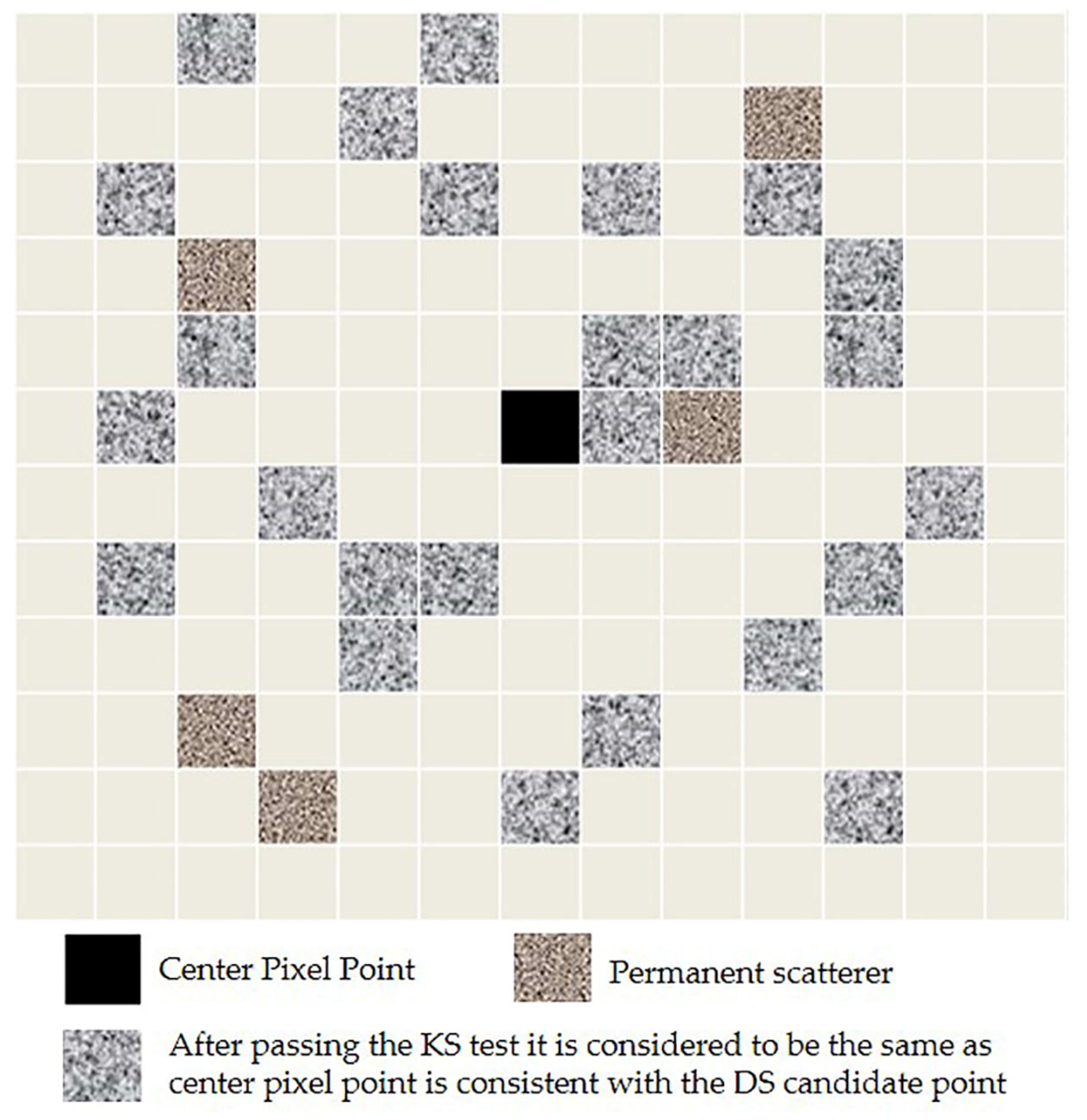
2.1. Spatial Adaptive Filtering Algorithm
- (1)
- Read the phase information of the original N(N−1)/2 interferograms.
- (2)
- The DS candidate points in the search window corresponding to a certain pixel are summed and considered as conforming if they are larger than the filtering threshold (25).
- (3)
- For each pixel that meets the requirement, all the phase values of the SHP in the window centered on it are summed and divided by the sum of the SHP, and the phase value of the center pixel is replaced by the average value.
- (4)
- Repeat Steps 2–3 until all pixels that meet the threshold requirements are replaced by the average phase value.
| Algorithm 1. Serial Spatial Adaptive Filtering Algorithm |
| Input: Three-dimensional complex array interferogram phase values p[s,i,j]. The KS test identified the SHP corresponding to the row and column data and the identification information of the pixel points in the search window (containing 1 and 0; 1 for SHP and 0 for others), N, M, and W. |
| Output: Interferogram phase values after filtering with a three-dimensional complex list pnosie |
| 1 for each n ∊ [0,N] do |
| 2 for each m ∊ [0,M] do |
| 3 W[n][m] ⃪ Obtain SHP identification information in the search window |
| 4 sum[n][m] ⃪ Calculate the sum of the numbers of W[n][i] |
| 5 if sum[n][m] > (Filter Threshol)) then |
| 6 phase[n][m] ⃪ Obtain the interferogram phase values corresponding to the pixel phase[:,n,m] |
| 7 fliter = (phase·W[n][m])/sum[n][m] |
| 8 pnoise[:,n,m] = fliter |
| 9 end for |
| 10 end for |
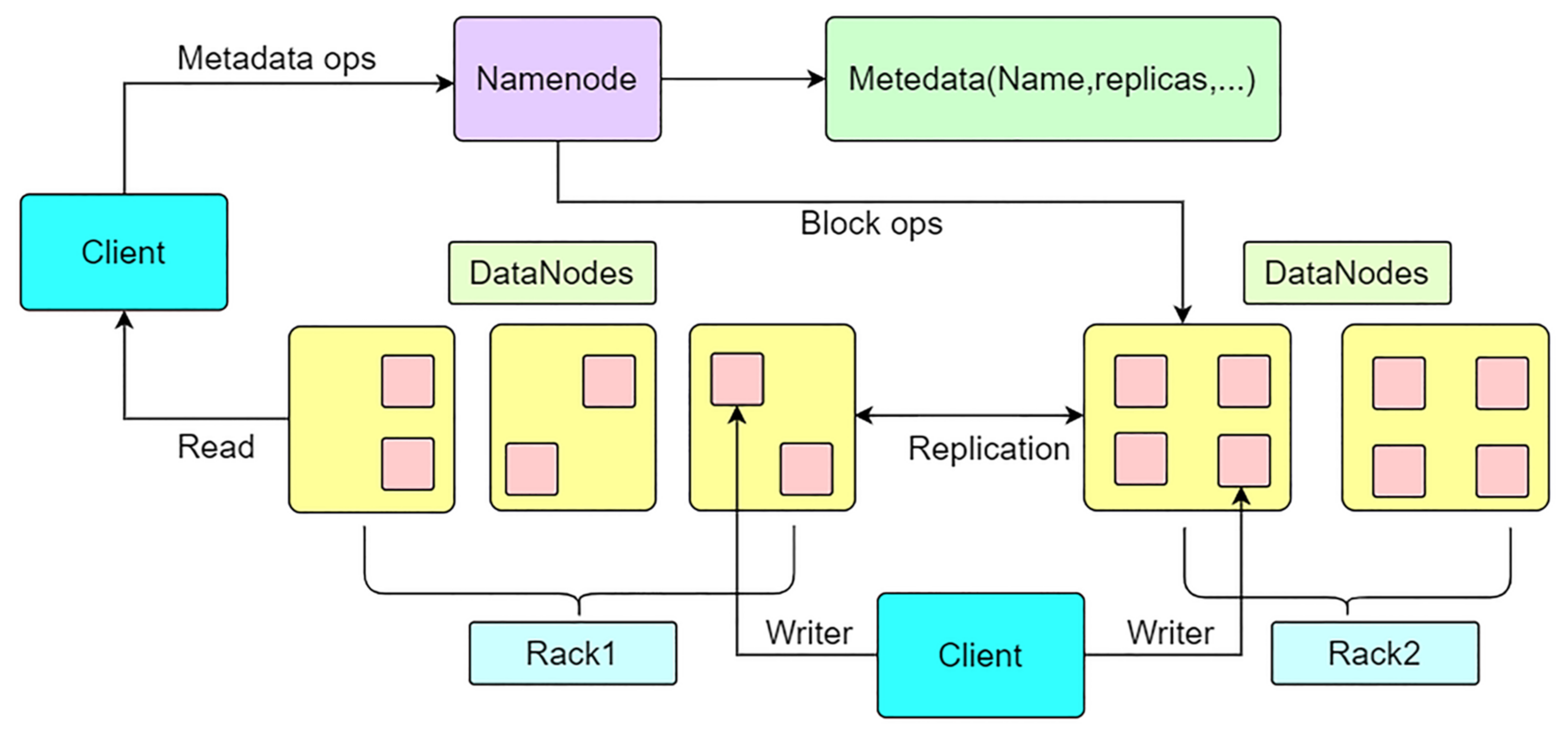
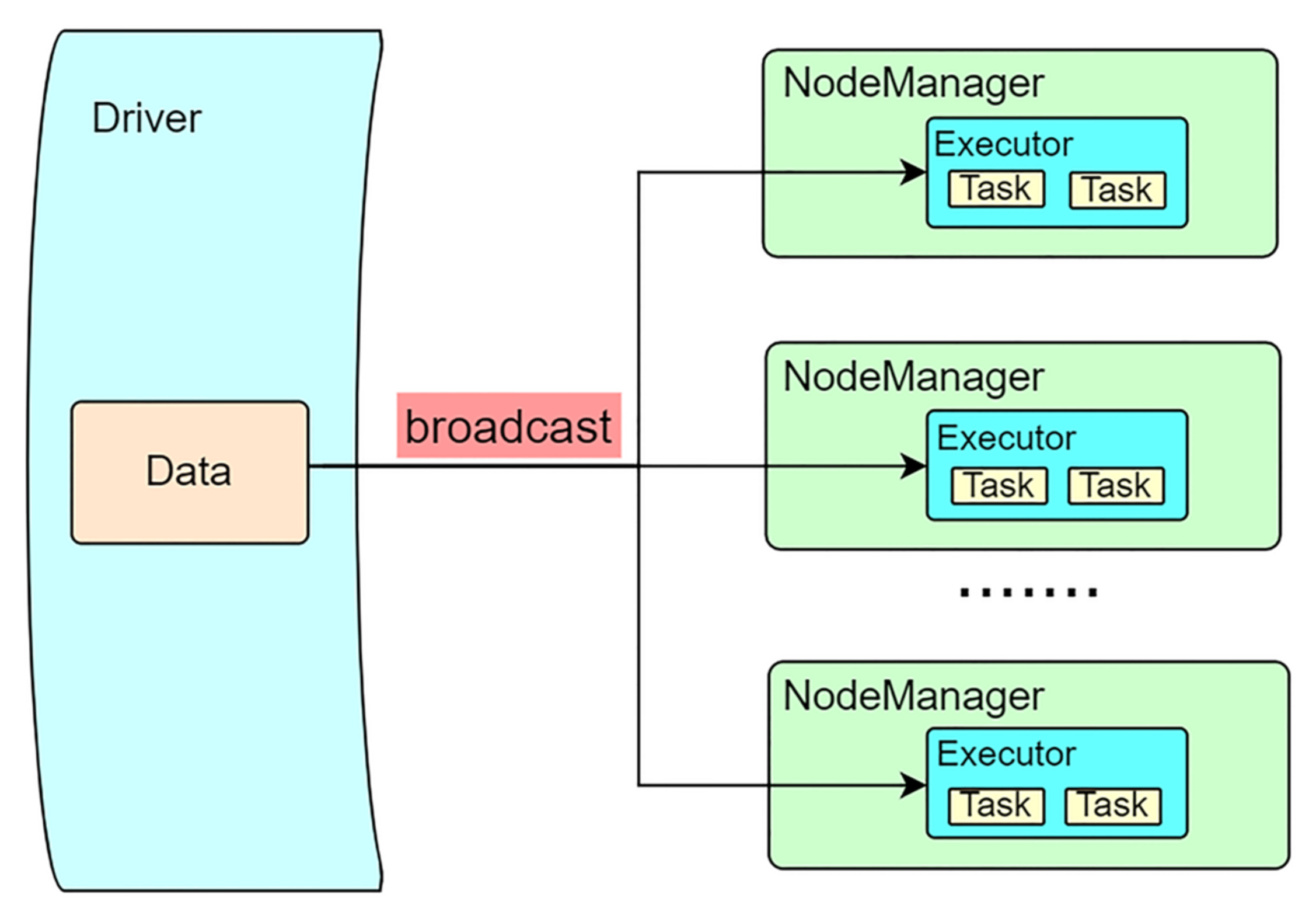
2.2. Hadoop Distributed Framework
2.3. Spark-Space Adaptive Filtering Algorithm
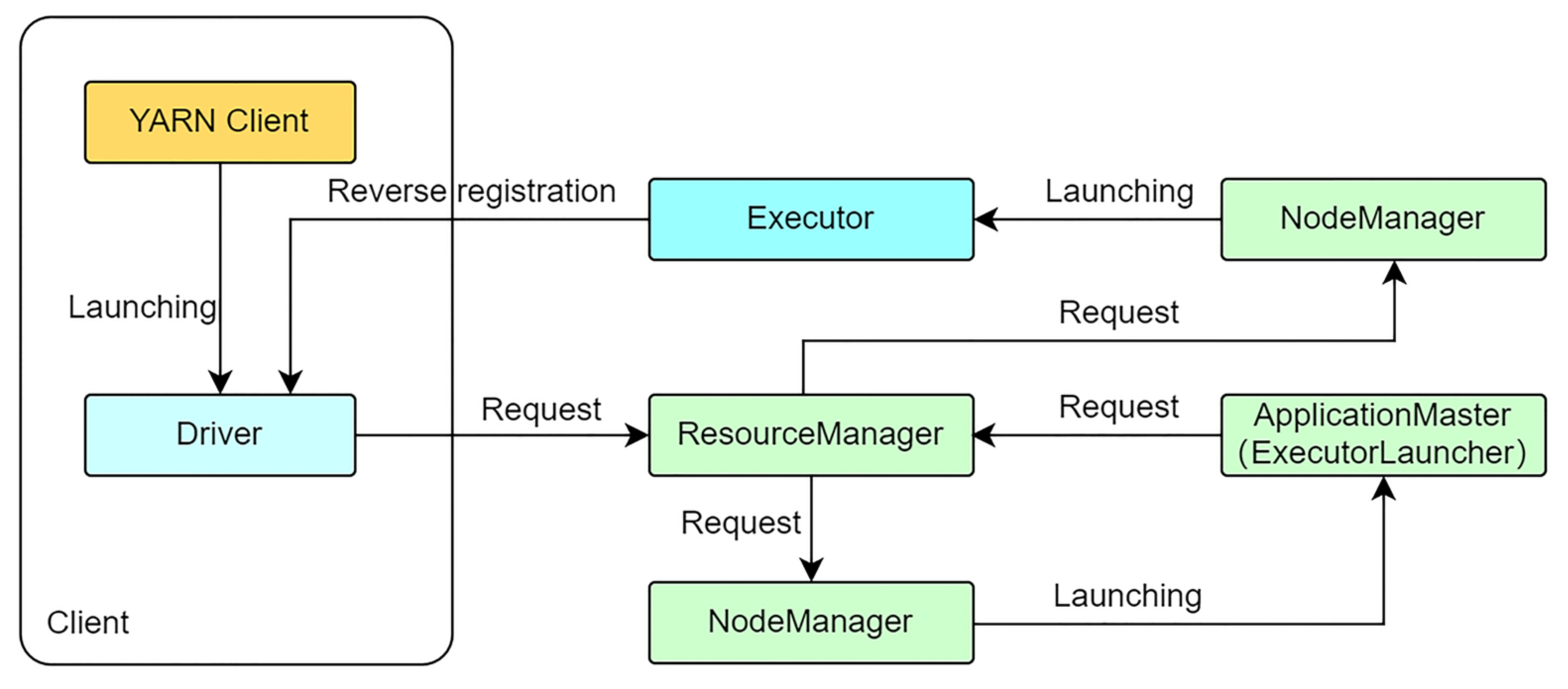
- (1)
- The user submits the application in the YARN cluster client and launches the driver process;
- (2)
- The driver process sends a request to the ResourceManager (RS) to launch the ApplicationMaster (AM);
- (3)
- RS receives the request and randomly selects a NodeManager (NM) to launch the AM;
- (4)
- After the AM is launched, a multi-process executor is launched via the NM for the RS requesting container resources;
- (5)
- Finally, the executor is reverse-registered to the driver, who sends a task to the executor for data processing. It is worth noting that in an actual production environment, YARN automatically schedules and manages these resources, and the user only needs to set the relevant hardware parameters (memory, cores, etc.) without considering the complex resource scheduling issues.
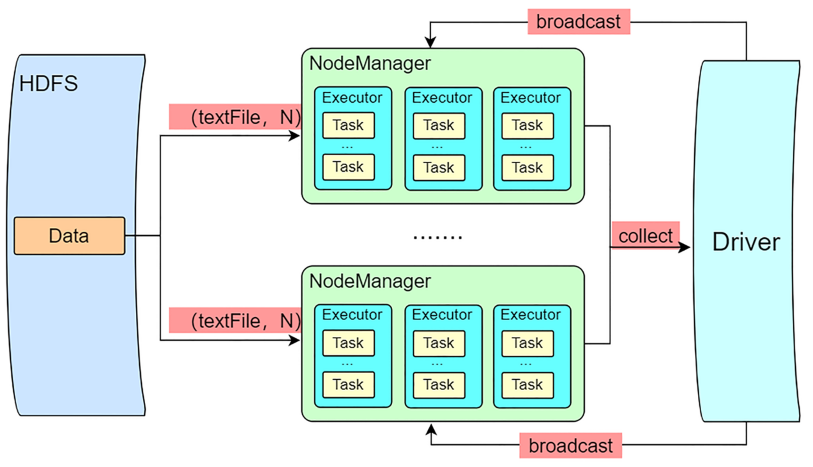
| Algorithm 2. Parallel Spark-based Spatial Adaptive Filtering Algorithm |
| Input: Three-dimensional complex array of interferogram phase values p[s,i,j]. The SHP-related data stored in the HDFS contains a total of M/t data, where t denotes the number of initiated Tasks. |
| Output: Phase value after 1D filtering fliter |
| 1 |
| 2 textfile<path,Task> ⃪ Distribute data to the started Task |
| 3 |
| 4 phase_bc = broadcast(p[s,i,j]) ⃪ Broadcast phase values to Executor |
| 5 |
| 6 map(lambda x: func(x)) |
| 7 for each n∊[0,M/t] do |
| 8 phase_bc_va ⃪ Obtain the interferogram phase broadcast to Executor |
| 9 phase[n][m] ⃪ Obtain the interferogram phase value of the corresponding pixel phase_bc_va[:,n,m] |
| 10 fliter = (phase·W[n][m])/sum[n][m] |
| 11 output fliter |
| 12 end for |
| 13 |
| 14 collect() ⃪ Collect data from each task for the master node |
3. Experimental Results and Analysis
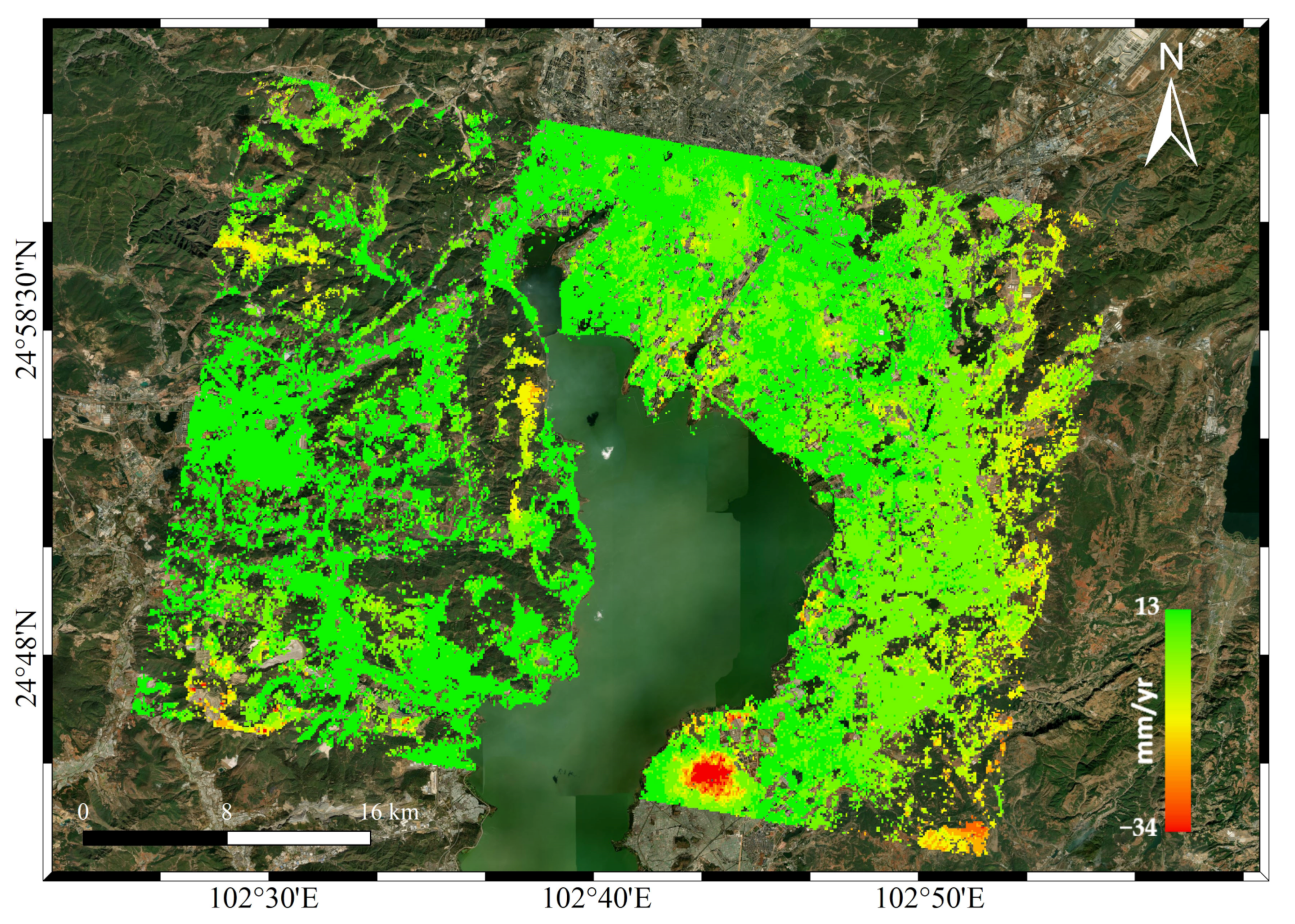
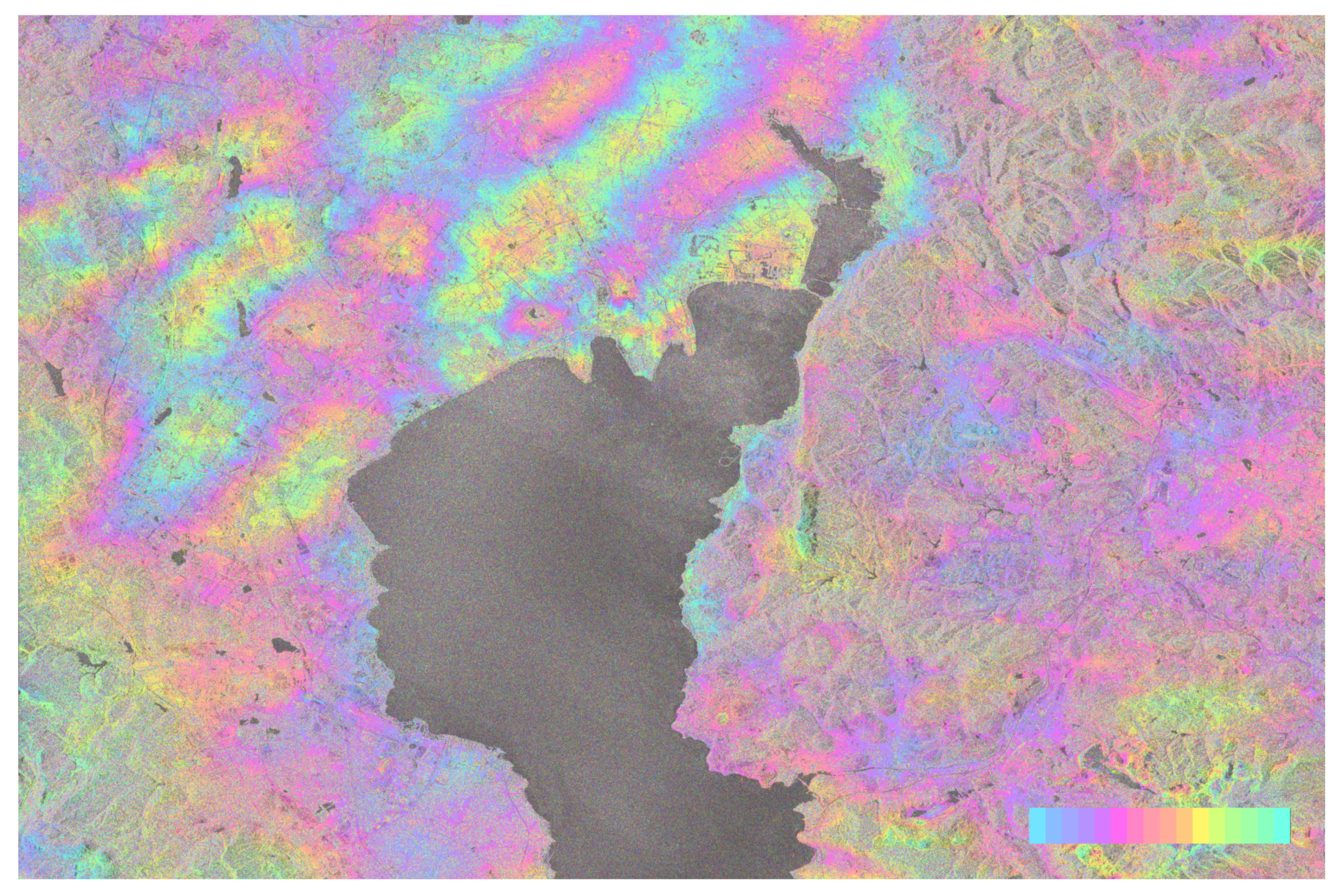
3.1. Overview of the Experimental Area
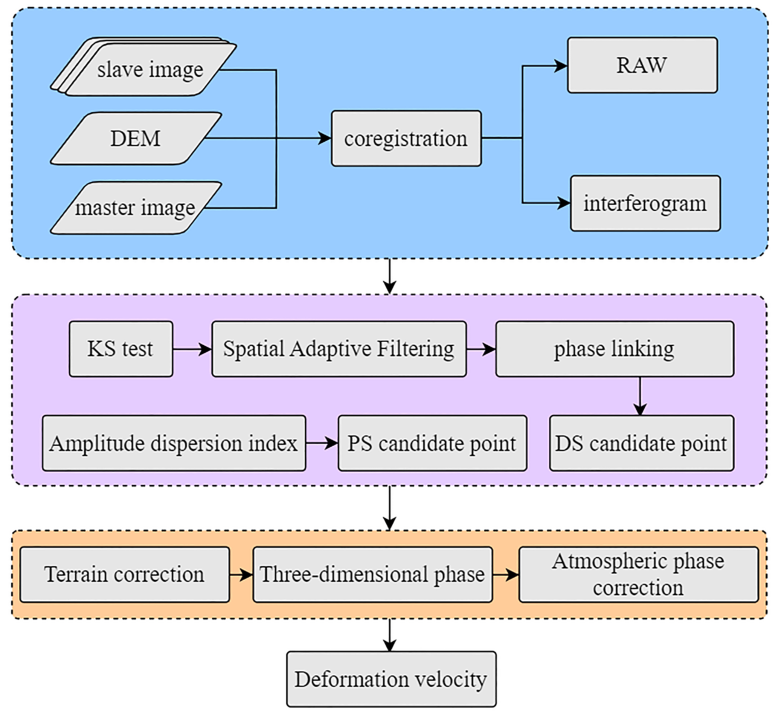
3.2. Data Processing Flow
3.3. Comparative Experiments and Analysis of Results
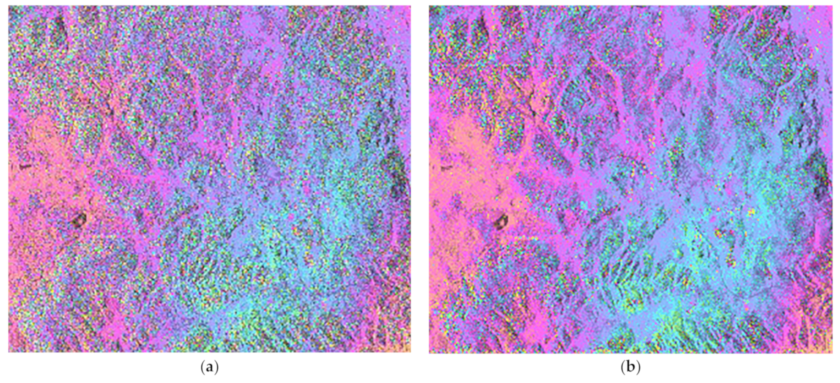
3.3.1. Accuracy Evaluation
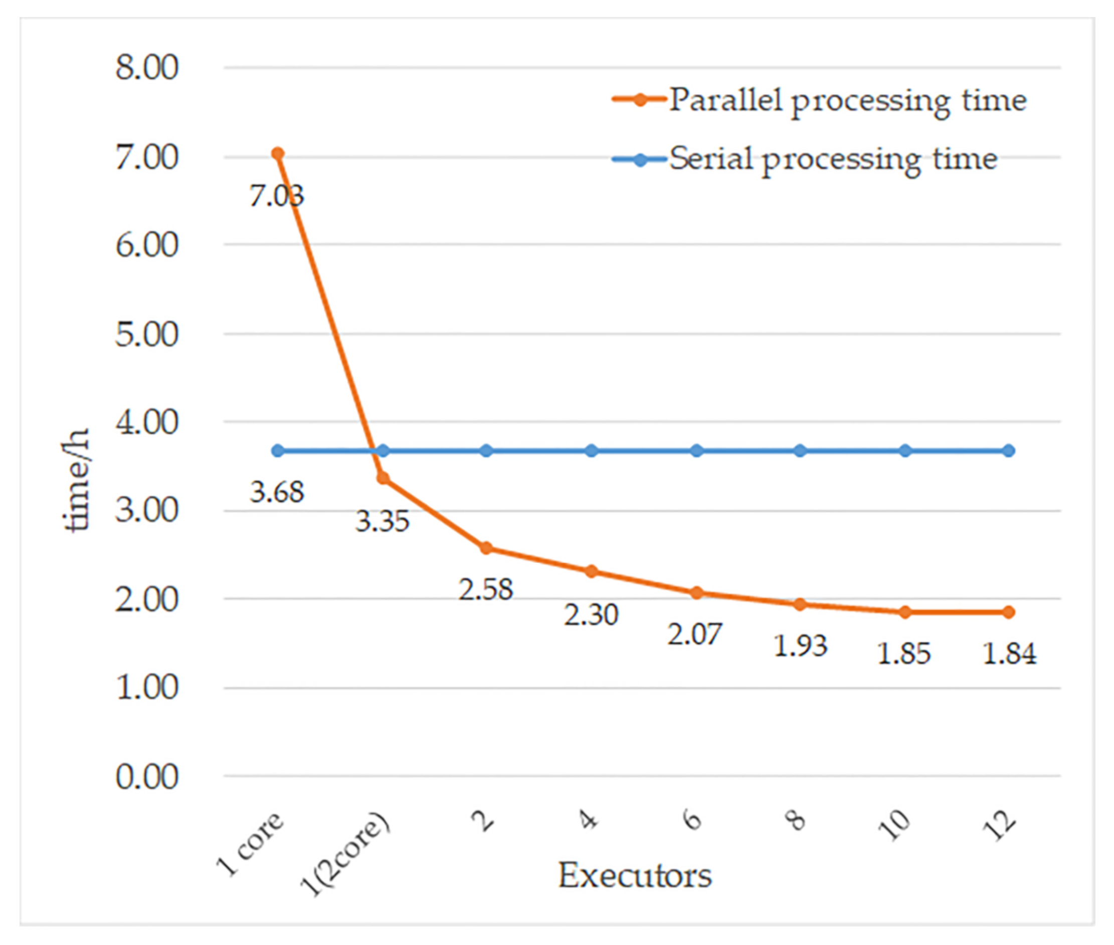
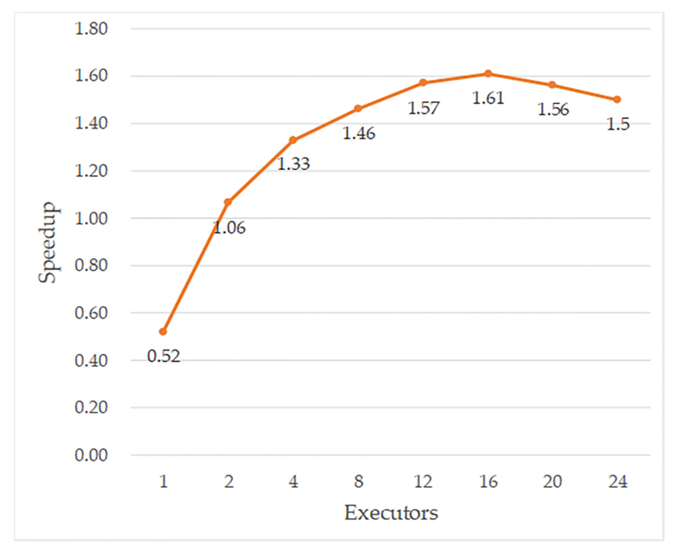
3.3.2. Performance Evaluation
4. Conclusions
Author Contributions
Funding
Data Availability Statement
Acknowledgments
Conflicts of Interest
References
- Ferretti, A.; Prati, C.; Rocca, F. Permanent scatterers in SAR interferometry. IEEE Trans. Geosci. Remote Sens. 2001, 39, 8–20. [Google Scholar] [CrossRef]
- Berardino, P.; Fornaro, G.; Lanari, R.; Sansosti, E. A new algorithm for surface deformation monitoring based on small baseline differential SAR interferograms. IEEE Trans. Geosci. Remote Sens. 2002, 40, 2375–2383. [Google Scholar] [CrossRef] [Green Version]
- Hooper, A. A multi-temporal InSAR method incorporating both persistent scatterer and small baseline approaches. Geophys. Res. Lett. 2008, 35, 1–5. [Google Scholar] [CrossRef] [Green Version]
- Lanari, R.; Mora, O.; Manunta, M.; Mallorqui, J.; Berardino, P.; Sansosti, E. A small-baseline approach for investigating deformations on full-resolution differential SAR interferograms. IEEE Trans. Geosci. Remote Sens. 2004, 42, 1377–1386. [Google Scholar] [CrossRef]
- Hooper, A.; Zebker, H.; Segall, P.; Kampes, B. A new method for measuring deformation on volcanoes and other natural terrains using InSAR persistent scatterers. Geophys. Res. Lett. 2004, 31, 1–5. [Google Scholar] [CrossRef]
- Lv, X.; Yazıcı, B.; Zeghal, M.; Bennett, V.; Abdoun, T. Joint-Scatterer Processing for Time-Series InSAR. IEEE Trans. Geosci. Remote Sens. 2014, 52, 7205–7221. [Google Scholar] [CrossRef]
- Fornaro, G.; Verde, S.; Reale, D.; Pauciullo, A. CAESAR: An Approach Based on Covariance Matrix Decomposition to Improve Multibaseline–Multitemporal Interferometric SAR Processing. IEEE Trans. Geosci. Remote Sens. 2015, 53, 2050–2065. [Google Scholar] [CrossRef]
- Dong, J.; Zhang, L.; Tang, M.; Liao, M.; Xu, Q.; Gong, J. Mapping landslide surface displacements with time series SAR interferometry by combining persistent and distributed scatterers: A case study of Jiaju landslide in Danba, China. Remote Sens. Environ. 2018, 205, 180–198. [Google Scholar] [CrossRef]
- Jiang, M.; Ding, X.L.; Li, Z.W. Homogeneous pixel selection algorithm for multitemporal InSAR. Chin. J. Geophys. 2018, 61, 4767–4776. [Google Scholar] [CrossRef]
- Gao, Y.; Gao, F.; Dong, J.; Wang, S. Change detection from synthetic aperture radar images based on channel weighting-based deep cascade network. IEEE J. Sel. Top. Appl. Earth Obs. Remote Sens. 2019, 12, 4517–4529. [Google Scholar] [CrossRef]
- Chen, H.; Shi, Z. A spatial-temporal attention-based method and a new dataset for remote sensing image change detection. Remote Sens. 2020, 12, 1662. [Google Scholar] [CrossRef]
- Kang, M.S.; Baek, J.M. Efficient SAR Imaging Integrated With Autofocus via Compressive Sensing. IEEE Geosci. Remote Sens. Lett. 2022, 19, 1–5. [Google Scholar] [CrossRef]
- Ferretti, A.; Fumagalli, A.; Novali, F.; Prati, C.; Rocca, F.; Rucci, A. A New Algorithm for Processing Interferometric Data-Stacks: SqueeSAR. IEEE Trans. Geosci. Remote Sens. 2011, 49, 3460–3470. [Google Scholar] [CrossRef]
- Zhu, J.; Li, Z.; Hu, J. Research progress and methods of InSAR for deformation monitoring. Acta Geod. Cartogr. Sin. 2017, 46, 1717. [Google Scholar] [CrossRef]
- Lin, H.; Ma, P.; Weixi, W. Urban infrastructure health monitoring with spaceborne multi-temporal synthetic aperture radar interferometry. Acta Geod. Cartogr. Sin. 2017, 46, 1421. [Google Scholar] [CrossRef]
- Mingzhou, W.; Tao, L.I.; Liming, J.; Kan, X.; Wenhao, W. An Improved Coherent Targets Technology for Monitoring Surface Deformation. Acta Geod. Cartogr. Sin. 2016, 45, 36. [Google Scholar] [CrossRef]
- Massey, F.J., Jr. The Kolmogorov-Smirnov test for goodness of fit. J. Am. Stat. Assoc. 1951, 46, 68–78. [Google Scholar] [CrossRef]
- Casu, F.; Elefante, S.; Imperatore, P.; Zinno, I.; Manunta, M.; Luca, C.D.; Lanari, R. SBAS-DInSAR Parallel Processing for Deformation Time-Series Computation. IEEE J. Sel. Top. Appl. Earth Obs. Remote Sens. 2014, 7, 3285–3296. [Google Scholar] [CrossRef]
- Zinno, I.; Elefante, S.; Mossucca, L.; Luca, C.D.; Manunta, M.; Terzo, O.; Lanari, R.; Casu, F. A First Assessment of the P-SBAS DInSAR Algorithm Performances Within a Cloud Computing Environment. IEEE J. Sel. Top. Appl. Earth Obs. Remote Sens. 2015, 8, 4675–4686. [Google Scholar] [CrossRef]
- De Luca, C.; Cuccu, R.; Elefante, S.; Zinno, I.; Manunta, M.; Casola, V.; Rivolta, G.; Lanari, R.; Casu, F. An On-Demand Web Tool for the Unsupervised Retrieval of Earth’s Surface Deformation from SAR Data: The P-SBAS Service within the ESA G-POD Environment. Remote Sens. Multidiscip. Digit. Publ. Inst. 2015, 7, 15630–15650. [Google Scholar] [CrossRef] [Green Version]
- Zinno, I.; Mossucca, L.; Elefante, S.; Luca, C.D.; Casola, V.; Terzo, O.; Casu, F.; Lanari, R. Cloud Computing for Earth Surface Deformation Analysis via Spaceborne Radar Imaging: A Case Study. IEEE Trans. Cloud Comput. 2016, 4, 104–118. [Google Scholar] [CrossRef]
- Zinno, I.; Casu, F.; Luca, C.D.; Elefante, S.; Lanari, R.; Manunta, M. A Cloud Computing Solution for the Efficient Implementation of the P-SBAS DInSAR Approach. IEEE J. Sel. Top. Appl. Earth Obs. Remote Sens. 2017, 10, 802–817. [Google Scholar] [CrossRef]
- De Luca, C.; Zinno, I.; Manunta, M.; Lanari, R.; Casu, F. Large areas surface deformation analysis through a cloud computing P-SBAS approach for massive processing of DInSAR time series. Remote Sens. Environ. 2017, 202, 3–17. [Google Scholar] [CrossRef]
- Duan, W.; Zhang, H.; Wang, C.; Tang, Y. Multi-Temporal InSAR Parallel Processing for Sentinel-1 Large-Scale Surface Deformation Mapping. Remote Sens. 2020, 12, 3749. [Google Scholar] [CrossRef]
- Tang, Y.; Wang, C.; Zhang, H.; You, H.; Zhang, W.; Duan, W.; Wang, J.; Dong, L. Parallel CS-InSAR for Mapping Nationwide Deformation in China. In Proceedings of the 2021 IEEE International Geoscience and Remote Sensing Symposium IGARSS, Brussels, Belgium, 25 January 2021; pp. 3392–3395. [Google Scholar]
- Da-di, M.; Yu-xin, H.; Tao, S.; Rui, S.; Xiao-bo, L. Airborne SAR real-time imaging algorithm design and implementation with CUDA on NVIDIA GPU. J. Radars 2013, 2, 481–491. [Google Scholar] [CrossRef]
- Sheng, G.; Qi-Ming, Z.; Jian, J.; Cun-Ren, L.; Qing-xi, T. Parallel processing of InSAR interferogram filtering with CUDA programming. Sci. Surv. Mapp. 2015, 1, 54–68. [Google Scholar]
- Popov, S.E.; Potapov, V.P. A Fast Search Algorithm for SqueeSAR Distributed Scatterers in the Problem of Calculating Displacement Velocities. Program. Comput. Softw. 2021, 47, 426–438. [Google Scholar] [CrossRef]
- Zhong, H.; Tang, J.; Zhang, S.; Huang, P. Combined Minimum Discontinuity Phase Unwrapping Based on Clusters. Geomat. Inf. Sci. Wuhan Univ. 2019, 44, 1363–1368. [Google Scholar] [CrossRef]
- Sadooghi, I.; Martin, J.H.; Li, T.; Brandstatter, K.; Maheshwari, K.; Ruivo, T.P.P.D.L.; Garzoglio, G.; Timm, S.; Zhao, Y.; Raicu, L. Understanding the Performance and Potential of Cloud Computing for Scientific Applications. IEEE Trans. Cloud Comput. 2017, 5, 358–371. [Google Scholar] [CrossRef]
- White, T. Hadoop: The Definitive Guide; O’Reilly Media, Inc.: Newton, MA, USA, 2012. [Google Scholar]
- Zaharia, M.; Chowdhury, M.; Franklin, M.J.; Shenker, S.; Stoica, I. Spark: Cluster computing with working sets. In Proceedings of the 2nd USENIX conference on Hot topics in cloud computing, Boston, MA, USA, 22–25 June 2010; p. 10. [Google Scholar]
- Ibrahim, S.; Jin, H.; Lu, L.; Wu, S.; Shi, X. Evaluating MapReduce on Virtual Machines: The Hadoop Case. In Proceedings of the Cloud Computing, First International Conference, CloudCom 2009, Beijing, China, 1–4 December 2009; pp. 519–528. [Google Scholar] [CrossRef]
- Shi, J.; Qiu, Y.; Minhas, U.F.; Jiao, L.; Wang, C.; Reinwald, B.; Özcan, F. Clash of the titans: MapReduce vs. Spark for large scale data analytics. Proc. VLDB Endow. 2015, 8, 2110–2121. [Google Scholar] [CrossRef] [Green Version]
- Yipeng, W.; Yongzhi, Z.; Chaoying, Z.; Xiaojie, L.; Yingyun, Z. Design and analysis of cloud platform for landslide monitoring in Heifangtai, Gansu province based on GPS and InSAR data. Bull. Surv. Mapp. 2019, 8, 106. [Google Scholar] [CrossRef]
- Huang, W.; Meng, L.; Zhang, D.; Zhang, W. In-Memory Parallel Processing of Massive Remotely Sensed Data Using an Apache Spark on Hadoop YARN Model. IEEE J. Sel. Top. Appl. Earth Obs. Remote Sens. 2017, 10, 3–19. [Google Scholar] [CrossRef]
- Yipeng, W.; Yongzhi, Z.; Chaoying, Z.; Yulei, L.; Zhang, T. Design of landslide monitoring cloud platform based on cloud computing technology: Taking Jingyang as an example. Bull. Surv. Mapp. 2019, 3, 128. [Google Scholar] [CrossRef]
- Li, Z.; Su, D.; Zhu, H.; Li, W.; Zhang, F.; Li, R. A Fast Synthetic Aperture Radar Raw Data Simulation Using Cloud Computing. Sens. Multidiscip. Digit. Publ. Inst. 2017, 17, 113. [Google Scholar] [CrossRef] [PubMed] [Green Version]
- Vavilapalli, V.K.; Murthy, A.C.; Douglas, C.; Agarwal, S.; Konar, M.; Evans, R.; Graves, T.; Lowe, J.; Shah, H.; Seth, S.; et al. Apache Hadoop YARN: Yet another resource negotiator. In Proceedings of the 4th Annual Symposium on Cloud Computing, Santa Clara, CA, USA, 1–3 October 2013. [Google Scholar]
- Sadashiv, N.; Kumar, S.M.D. Cluster, grid and cloud computing: A detailed comparison. In Proceedings of the 2011 6th International Conference on Computer Science Education (ICCSE), Singapore, 3–5 August 2011; pp. 477–482. [Google Scholar] [CrossRef]
- Xia, J.B.; Wei, Z.K.; Fu, K.; Chen, Z. Review of research and application on Hadoop in cloud computing. Comput. Sci. 2016, 43, 6–11. [Google Scholar]
- Reyes-Ortiz, J.L.; Oneto, L.; Anguita, D. Big Data Analytics in the Cloud: Spark on Hadoop vs MPI/OpenMP on Beowulf. Procedia Comput. Sci. 2015, 53, 121–130. [Google Scholar] [CrossRef] [Green Version]
- Borthakur, D. HDFS architecture guide. Hadoop Apache Proj. 2008, 53, 2. [Google Scholar]
- Yang, C.; Huang, Q.; Li, Z.; Liu, K.; Hu, F. Big Data and cloud computing: Innovation opportunities and challenges. Int. J. Digit. Earth Taylor Fr. 2017, 10, 13–53. [Google Scholar] [CrossRef] [Green Version]
- Verma, A.; Mansuri, A.H.; Jain, N. Big data management processing with Hadoop MapReduce and spark technology: A comparison. In Proceedings of the 2016 Symposium on Colossal Data Analysis and Networking (CDAN), Indore, India, 18–19 March 2016; pp. 1–4. [Google Scholar] [CrossRef]
- Pan, F.; Yue, Y.; Xiong, J.; Hao, D. I/O characterization of big data workloads in data centers. In Proceedings of the Workshop on Big Data Benchmarks, Performance Optimization, and Emerging Hardware, Salt Lake City, UT, USA, 1 March 2014; pp. 85–97. [Google Scholar]
- Zhang, Y.; Gao, Q.; Gao, L.; Wang, C. iMapReduce: A distributed computing framework for iterative computation. J. Grid Comput. 2012, 10, 47–68. [Google Scholar] [CrossRef]
- Kambatla, K.; Chen, Y. The Truth About {MapReduce} Performance on {SSDs}. In Proceedings of the 28th Large Installation System Administration Conference (LISA14), Seattle, WA, USA, 9–14 November 2014; pp. 118–126. [Google Scholar]
- Yu, G.; Gu, Y.; Bao, Y.B.; Wang, Z.G. Large scale graph data processing on cloud computing environments. Jisuanji Xuebao (Chin. J. Comput.) 2011, 34, 1753–1767. [Google Scholar] [CrossRef]
- Xiong, P.; Zuo, X.; Li, Y.; You, H. Application of dual-polarized Sentinel-1 data to subsidence monitoring in Kunming. Prog. Geophys. 2020, 35, 1317–1322. [Google Scholar]
- Guo, S.P.; Zhang, W.F.; Kang, W.; Zhang, T.; Li, Y. The Study on Land Subsidence in Kunming by Integrating PS, SBAS and DS InSAR. Remote Sens. Technol. Appl. 2022, 37, 460–473. [Google Scholar]
- Keren, D.A.I.; Yongbo, T.I.E.; Qiang, X.U.; Ye, F.E.N.G.; Guanchen, Z.H.U.O.; Xianlin, S.H.I. Early identification of potential landslide geohazards in alpine-canyon terrain based on SAR interferometry—A case study of the middle section of Yalong river. J. Radars 2020, 9, 554–568. [Google Scholar]
- Marinkovic, P.S.; Hanssen, R.F.; Kampes, B.M. Utilization of parallelization algorithms in InSAR/PS-InSAR processing. In Proceedings of the Envisat & ERS Symposium, Salzburg, Austria, 6–10 September 2004; p. 572. [Google Scholar]
- Hooper, A.; Spaans, K.; Bekaert, D.; Cuenca, M.C.; Arıkan, M.; Oyen, A. StaMPS/MTI Manual; Delft Institute of Earth Observation and Space Systems Delft University of Technology: Delft, The Netherlands, 2010; pp. 1–44. [Google Scholar]


| Name | Configuration |
|---|---|
| operating system | Linux RedHat 4.8.5 |
| Hadoop | Version 3.2.2 |
| Spark | Version 3.0.2 |
| Java | Version 1.8 |
| Python | Version 2.7.5 |
| Doris (Master node installation only) | Version 5.0.3 |
| StaMPS (Master node installation only) | Version 4.1 |
| Task Number | Run Time/s |
| 240 | 99 |
| 320 | 95 |
| 400 | 90 |
| 480 | 86 |
| 560 | 89 |
| 640 | 93 |
Disclaimer/Publisher’s Note: The statements, opinions and data contained in all publications are solely those of the individual author(s) and contributor(s) and not of MDPI and/or the editor(s). MDPI and/or the editor(s) disclaim responsibility for any injury to people or property resulting from any ideas, methods, instructions or products referred to in the content. |
© 2023 by the authors. Licensee MDPI, Basel, Switzerland. This article is an open access article distributed under the terms and conditions of the Creative Commons Attribution (CC BY) license (https://creativecommons.org/licenses/by/4.0/).
Share and Cite
Li, Y.; Song, W.; Jin, B.; Zuo, X.; Li, Y.; Chen, K. A SqueeSAR Spatially Adaptive Filtering Algorithm Based on Hadoop Distributed Cluster Environment. Appl. Sci. 2023, 13, 1869. https://doi.org/10.3390/app13031869
Li Y, Song W, Jin B, Zuo X, Li Y, Chen K. A SqueeSAR Spatially Adaptive Filtering Algorithm Based on Hadoop Distributed Cluster Environment. Applied Sciences. 2023; 13(3):1869. https://doi.org/10.3390/app13031869
Chicago/Turabian StyleLi, Yongning, Weiwei Song, Baoxuan Jin, Xiaoqing Zuo, Yongfa Li, and Kai Chen. 2023. "A SqueeSAR Spatially Adaptive Filtering Algorithm Based on Hadoop Distributed Cluster Environment" Applied Sciences 13, no. 3: 1869. https://doi.org/10.3390/app13031869
APA StyleLi, Y., Song, W., Jin, B., Zuo, X., Li, Y., & Chen, K. (2023). A SqueeSAR Spatially Adaptive Filtering Algorithm Based on Hadoop Distributed Cluster Environment. Applied Sciences, 13(3), 1869. https://doi.org/10.3390/app13031869