Featured Application
This study presents an overview of the several mitigation measures, including several check dams and flexible net barriers constructed in a typical Alpine torrential catchment in northern Slovenia (Europe) in order to protect infrastructure (i.e., ski resort cabin lift station, access road to the station, downstream settlements) against sediment-related disasters due to torrential hazards, such as flash floods and debris floods, debris flows, and shallow landslides. This newly introduced combination of technical countermeasures in Slovenia withstood the extreme floods in August 2023.
Abstract
Different sediment-related disasters due to torrential hazards, such as flash floods, debris flows, and landslides, can occur in an Alpine torrential catchment. When protecting infrastructure and human lives, different structural and non-structural protection measures can be used to mitigate permanent and future risks. An overview of the mitigation measures constructed near the Krvavec ski resort in northwest Slovenia (Central Europe) is presented. In May 2018, an extreme debris flood occurred in this area, causing significant economic damage. After the May 2018 event, different field investigations (i.e., geological and topographic surveys) and modeling applications (e.g., hydrological modeling, debris flow) have been conducted with the purpose of preparing the required input data for the design of protection measures against such disasters in future—due to climate change, more disasters are expected to happen in this torrential watershed. The mitigation includes the restoration of local streams, the construction of a large slit check dam for sediment retention, the construction of several smaller check dams and the construction of 16 flexible net barriers with an estimated ~8000 m3 retention volume for controlling in-channel erosion in steep torrential streams. Additionally, in order to observe and monitor potential future extreme events, an extensive monitoring system has been established in the investigated area. This monitoring system will cover measurements of flexible net corrosion, the estimation of concrete abrasion at check dams, periodical geodetic surveys using small drones (UAV), hydro-meteorological measurements using rainfall gauges and water level sensors. The recent extreme floods of August 2023 also hit this part of Slovenia, and this combination of technical countermeasures withstood the event and prevented large amounts of coarse debris from being transported to the downstream section and devastating infrastructure, as was the case in May 2018 during a less extreme event. Therefore, such mitigation measures can also be used in other torrential catchments in the Alpine environment.
1. Introduction
Alpine areas around the world, including the Alps in Europe, are susceptible to different gravitational and rainfall-triggered natural hazards, such as shallow and deep-seated landslides [1,2], dry and wet debris flows [3,4,5], flash floods [6,7,8,9] or a combination of these hazards that can be initiated during regular but extreme catastrophic rainfall events [10,11,12]. The Alps in Europe cover more than 300,000 km2 and are located in several European countries. Slovenia is one of the countries located in Central Europe, and its north and northwestern parts are within the Alps. It is expected that climate change will increase both the magnitude and frequency of extreme torrential events [13,14] that will cover larger areas during single disaster events. Therefore, different structural and non-structural mitigation measures should be applied in order to protect existing infrastructure and human lives. Different types of measures can be used, ranging from so-called grey measures [1,15] to green-blue [16] solutions and a combination of them (i.e., hybrid solutions [17]). Green or blue solutions are often promoted in different disciplines [18,19] since they can be related to multiple benefits, such as increased biodiversity. Moreover, even in torrential risk management in the Alpine environment, wooden dams were often used in the past for the stabilization of unstable slopes and torrential channels and limiting sediment transport from upland parts of torrential watersheds to urban areas. However, classical engineering grey measures, such as concrete or reinforced concrete check dams [1], are still very frequently built to mitigate torrential risks. When enhancing knowledge about torrential processes, detailed observations of natural phenomena are needed, asking for the collection of relevant field data, such as information about triggering mechanisms, magnitudes of debris flow and peak discharges of flash floods, or debris flood characteristics, such as velocities and pressures on infrastructure [20,21]. The pressure and dynamic impact forces are the most important parameters used for the design of protection measures, such as flexible net barriers or check dams against debris floods and debris flows [22,23]. The same applies for some other infrastructure, such as coastal structures used for tsunami protection [24,25]. Therefore, the main objectives of this study is to: (i) present different counter measures proposed to mitigate torrential hazards in the Krvavec ski resort area in northern Slovenia, (ii) to describe the monitoring system used to observe and detect potential future torrential events, and (iii) present some preliminary results with respect to functioning of the mitigation countermeasures during the recent extreme August 2023 flood that occurred in Slovenia [26,27]. In Krvavec area, flexible net barriers have been constructed in torrential channel beds for sediment retention and channel stabilization for the first time in Slovenia, and, therefore, this cases study shows that this type of torrential structures can be used as technical countermeasures in steep torrential streams in the Alpine environment in Slovenia.
The original contribution of the presented case study lies in the thoughtfully selected combination of structural measures of different types (flexible ring net barriers in steep channels, bank stabilization and low check dams in less steep channels, and a reinforced concrete slit check dam) that can be used as an open-air monitoring site for the effectiveness of such measures with respect to flexible barriers behavior using: (i) innovative monitoring devices (i.e., Guards), and (ii) combining estimated sediment transport quantities from retained debris behind barriers and LiDAR measurements using drones, with concrete abrasion experiments of diverse concrete specimens subjected to real field conditions. The successful functioning of the system during the extreme August 2023 event (if compared to the 2018 debris flood) confirms the proper design of the system and the possibility of using torrential countermeasures for field research on interactions between natural processes and torrential structures.
2. Materials and Methods
2.1. Case Study Description: Krvavec Ski Resort Area
The Krvavec ski resort area is part of the Kamnik-Savinja Alps, a mountain range located in the northern part of Slovenia (Figure 1). The total area of Kamnik-Savinja Alps in Slovenia is around 1000 km2, and there are several mountains with elevations above 2000 m a.s.l., with the highest one being Grintovec Mountain with an elevation of 2558 m a.s.l. The Krvavec ski resort stretches from around 1500 m a.s.l. to around 2000 m a.s.l. The area is characterized by steep slopes and narrow valleys (Figure 2). The cabin lift is the main means of transport for skiers in winter during the ski season. As can be seen from Figure 1, there are two steep torrential ravines (i.e., the Brezovški graben and the Lukenjski graben) in the upstream slopes from the station of the cabin car. The average longitudinal channel slope of these two torrents is ~25–30%, and the total catchment area is close to 2 km2 [22]. Around three-quarters of both catchment areas are forested, while the rest are agricultural areas [22].
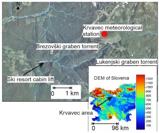
Figure 1.
Location of the Krvavec ski resort area on the elevation map of Slovenia (legend is in meters above sea level) and an overview of the situation in the torrents upstream of the valley station of the Krvavec ski resort cabin lift. Slovenia is positioned between 45.50526° to 46.83694° (latitude) and 13.52639° to 16.45091° (longitude). The Krvavec meteorological station is positioned at 14.5333° longitude and 46.2973° latitude and at 1742 m a.s.l.
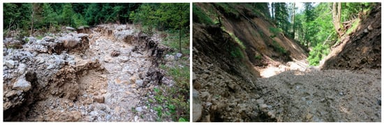
Figure 2.
Two photos of the situation in the Brezovški graben and Lukenjski graben torrents, respectively. The channel width is between 1–2 m to several meters.
The mean annual precipitation at the top of the Krvavec ski resort area (approx. 1700 m a.s.l.) is around 1620 mm (in the period 2010–2020), with no clear seasonal pattern (Figure 3). Moreover, there is a clearer pattern in the monthly rainfall erosivity distribution with a clear peak in the summer period (Figure 3). The rainfall erosivity was calculated based on the 30-m rainfall data for the 2010–2020 period based on the RUSLE methodology [28] and using the RIST software [29]. The average annual rainfall erosivity in the 2010–2020 period was around 3531 MJ × mm × ha−1 × h−1 × year−1, which can be regarded as relatively large [30]. Therefore, it is evident that hydro-meteorological events can occasionally be relatively extreme in this alpine part of Slovenia. In combination with steep slopes and other torrential characteristics, this can lead to rainfall events, such as the one that occurred in May 2018 (Section 2.2). This local thunderstorm triggered a local debris flood that partially devastated the valley station of the Krvavec ski resort cable car and interrupted the local access road to the station [22]—for protection against such torrential events, several structural protection measures were built in the past [22,23], but most of these torrential structures were already in relatively bad condition before, and especially after the May 2018 event (Section 2.3).
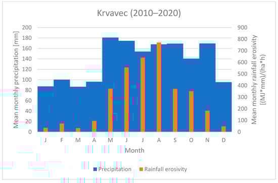
Figure 3.
Mean monthly precipitation and rainfall erosivity at the Krvavec meteorological station in the period 2010–2020.
2.2. Extreme Debris Flood in 2018
On 30 May 2018, a relatively extreme rainfall event occurred in this area [22]. Around 50 mm of rainfall fell in around 30 min, corresponding to the statistically estimated return period of over 50 years. The total event duration was very short (less than 3 h), and the majority of rainfall was concentrated in around 15–30 min (Figure 4). The rainfall erosivity for this specific event based on the 30-m rainfall data can be estimated to be over 1420 MJ × mm × ha−1 × h−1 × year−1, which is almost half of the total annual rainfall erosivity and almost twice as large as the average monthly erosivity at the Krvavec meteorological station (Figure 3). Furthermore, in the 2010–2020 period, this was the event with the second-highest rainfall erosivity. More specifically, the average erosivity per event at the Krvavec meteorological station was around 90 MJ × mm × ha−1 × h−1 × year−1.
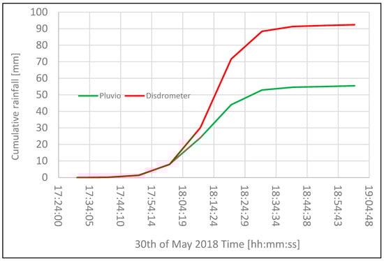
Figure 4.
Measured cumulative rainfall using an optical disdrometer and a pluviograph at the Krvavec meteorological station at 1742 m a.s.l. during the extreme event that occurred on 30 May 2018.
As indicated by Bezak et al. [22], the extreme rainfall in May 2018 triggered the local debris flood and caused intense erosion and sedimentation processes in both Brezovški graben and Lukenjski graben torrents. At the valley station of the Krvavec cable car, around 10,000 m3 of relatively coarse debris was deposited, and it was assumed that the main source of the debris material was the Brezovški graben since the debris material from the Lukenjski graben was deposited upstream (before the confluence of the Brezovški graben and Lukenjski graben torrents) from the valley station of the Krvavec cable car (i.e., in the debris flow fan area) [22]. The debris flood caused extensive damage to the existing torrential infrastructure in both torrents (Figure 5). Hence, in order to protect the valley station of the cable car and the downstream area along the access road to the station, new countermeasures needed to be implemented (Section 3.3).
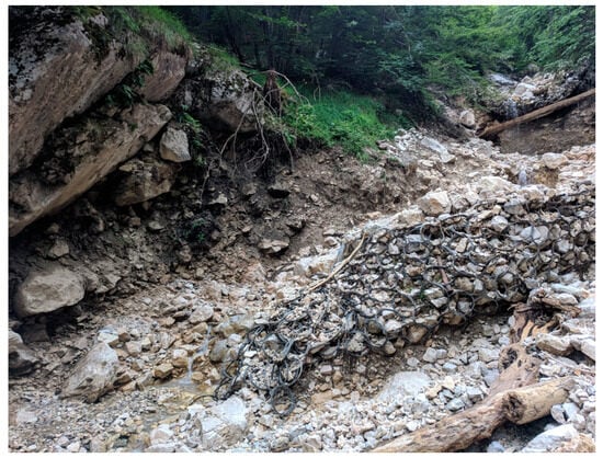
Figure 5.
One example of the consequences of the May 2018 event on the existing infrastructure in both torrents: a partially destroyed already filled flexible barrier.
2.3. Overview of the Mitigation Measures
In both torrents and prior to the May 2018 debris flood, there were several countermeasures, such as smaller check dams, gabion walls, wooden dams and low weirs already built to mitigate torrential hazards. However, these objects were destroyed to a large extent during the May 2018 event (Figure 5). Therefore, in order to mitigate the torrential risk in the future, new structural measures were planned for both torrents [22,23].
After the May 2018 event, a geological survey was carried out to determine geological conditions for planning and executing new mitigation measures (Figure 6). The main objective of the field survey was to estimate the possibility and magnitude of future mass movement and debris flood events. Areas with deposited debris material and areas with high erosion potential (Figure S1) were identified to secure input data for debris flood modeling and countermeasures design process.
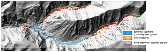
Figure 6.
Engineering geological map of the area with the identification of the main sediment sources.
Mitigation measures were roughly divided into three sections, respectively, phases (Figure 7). The first phase was a restoration of existing concrete structures (channel regulation works) on the Reka torrent, i.e., downstream of the Brezovški and Lukenjski torrents confluence. The second phase was planning and building a large slit check dam just downstream at the confluence of both torrents to temporarily retain future mass flows and slowly dose debris to the downstream section. In this location, there was already a small check dam, but the capacity of the sediment trap was only about 500 m3, which is a relatively small capacity compared to possible future events magnitude (volumes). A new slit check dam is designed with the largest possible sediment capacity in this location of close to 14,000 m3. The third phase includes measures to reduce erosion potential in the Brezovški and Lukenjski graben catchments. Both upstream sections have a large erosion potential, and a large amount of mixed coarse and fine debris material can be mobilized during future rainfall events. Since the area is hardly assessable even on foot, non-conventional countermeasures were sought. As an appropriate structure, a flexible ring-net debris flow barrier was selected, which can be transported to a construction site with helicopters or forestry cableways. No heavy machinery (such as excavators) is needed for installation—as it could not be applied—and light machinery was applied (such as so-called spider excavators). The main objective of the third phase was to reduce in-channel erosion intensity via stabilization of the torrent channels (side-slopes reduction at the same time). Geological information shown in Figure 6 was used for the selection of the optimal locations of the flexible net barriers. All three phases together present a holistic technical solution for this endangered torrential area and will reduce mass-flow-related hazards for downstream areas (cabin lift valley station, access road, Grad village, etc.).
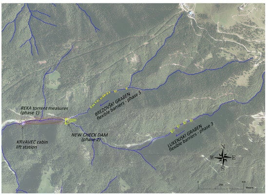
Figure 7.
Location of proposed measures and an indication of the three main phases used to mitigate the future risk of torrential hazards.
3. Results and Discussion
3.1. Reka Torrent Mitigation Measures (Phase 1)
The Reka torrent was already regulated in the past (in the last few decades), but mainly concrete and wooden structures were in relatively poor condition, and the May 2018 event severely damaged or destroyed most of them. This section of the Reka torrent is steep, and the structures such as small check dams, low weirs and bank protections are a necessity for channel stabilization. During construction phase 1, executed in 2019 and 2020 (pre-COVID-19), some of the structures were renewed, but most of them were completely reconstructed (Figure 8). Banks with erosion were protected with stone rip-rap structures.
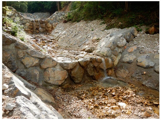
Figure 8.
An example of the Reka torrent measures (carried out in 2019, before COVID-19).
3.2. New Slit Check Dam (Phase 2)
Due to the high risk of similar or even more severe mass flow events in the future, a large 10.5 m high check dam with approximately 14,000 m3 sediment trap capacity was designed on the confluence of Brezovški and Lukenjski torrent. The check dam was designed as a slit dam to have minimal impact on geomorphological processes in this section and with the aim of ensuring the sediment connectivity and not to completely stop the sediment transport process. Therefore, the sediment transport process will not be completely interrupted, except for extreme events during which large masses of coarse sediments will be mobilized and could present a significant hazard for downstream areas. In the dam design phase, geotechnical research (boreholes, laboratory) was carried out to obtain reliable input data for the dam structural design. Check dam with a construction height of 10.5 m is designed for the dynamic impact of mass flows. It will be built as a reinforced concrete structure, covered with a mixture of concrete and rocks, to ensure a more nature-friendly look.
Together with a new slit check dam, some additional structures will be built to ensure the stability of the upstream section of the confluence (Figure 9). These sections of both torrents will be modified to provide larger sediment trap capacity and erosion stability. The check dam is designed in a location with an access road so that the sediments can be removed regularly, and the whole sediment trap volume is available.
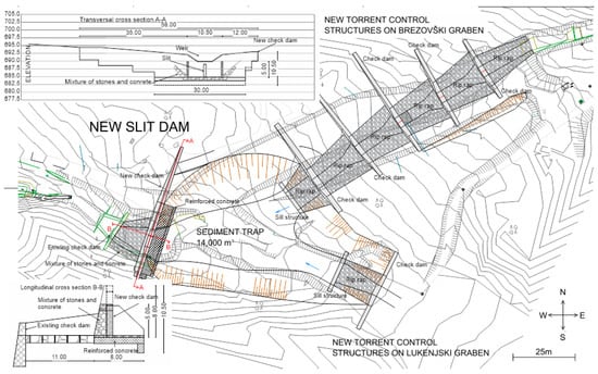
Figure 9.
The slit check dam location and its main characteristics, including the transversal and longitudinal cross sections. The spacing among contour lines is 2 m. Additional structures that are to be built are also shown in the figure (e.g., several sill structures).
3.3. Flexible Net Barriers (Phase 3)
A series of 12 flexible barriers were installed in Brezovški graben (12) and 4 in Lukenjski graben (4) to prevent side erosion (bank collapses, slumps) and thus to limit sediment supply from sediment sources (Figure 10). The height of the barriers varies between 2.5 and 6 m, and the sediment trap capacity is between 100 and 800 m3. The top width of the barriers varies between 9 and 25 m. The total retention volume was estimated for 4 barriers in the Lukanjski graben to be over 3000 m3 and for 12 barriers in the Brezovški graben to be close to 5000 m3.
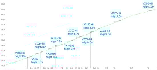
Figure 10.
A longitudinal profile of the Brezovški graben with the locations of the 12 flexible net barriers.
All the barriers were designed and dimensioned using the DEBFLOW online tool developed by Geobrugg [31]. The design of the barriers was modified because the deposits are not intended to be removed after the events, but the main purpose of the barriers is to reduce channel slope, reduce velocities and support unstable channel banks. Because of this specific design, not all barriers are designed for debris flow impact, but all of them are designed for overflowing forces. The upstream barriers and the barriers with larger distances to the next upstream barriers are designed for debris flow impact, which is one of the possible scenarios in the phase where barriers will be filling up with sediments. The final state of the barriers will be, when all of them are filled up, torrential bed slope reduced and bank erosion mostly mitigated. Based on the topographic characteristics, VX-type (Geobrugg) barriers were selected [31] (Figure 11). Some of them were customized with additional ropes and anchors since there was no need to use stronger, more resistant nets, but only to add some ropes to fulfill all the design requirements (stability, resistance).
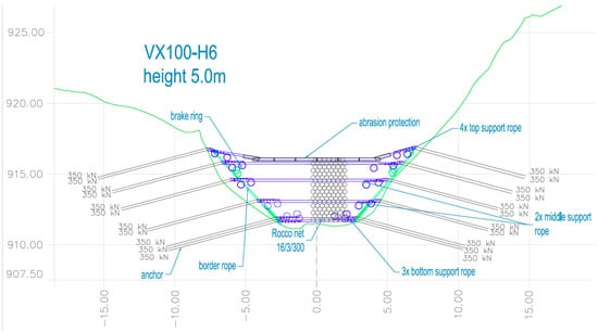
Figure 11.
Example of a designed VX barrier.
Special equipment was used for the installation of the barriers. Logging lifts were installed to transport the construction material to the construction sites. Most of the work was performed manually (drilling, installation) (Figures S2–S5).
3.4. Ongoing Monitoring
The monitoring system of torrential processes in the Krvavec area can be divided into the following parts:
- Measuring local rainfall using one tipping bucket as a rainfall gauge (resolution 0.1 mm) (will be installed at the top of Brezovški graben torrent);
- The Brezovški graben is regularly surveyed using Unmanned Aerial Vehicles (UAV drones), and surface changes (eroded slopes and new deposits upstream of the flexible barriers) between the two field measurements are determined from a difference between two consecutive LiDAR maps of the torrent. These measurements will explicitly tell us about erosion and sedimentation dynamics in the torrential channel and reveal the efficacy of the built flexible net barriers to retain coarse torrential debris. After they are filled up with coarse debris, they will support unstable torrential flanks, and sediment transport to downstream sections closer to the cable car station will increase again;
- Six devices, called Guards®, were installed on four flexible barriers in the Brezovški graben (barriers 1, 3, 7, 8, 9, and 12) and on two flexible barriers in the Lukanjski graben (barriers 2 and 6). Introduced in late 2020, a Guard® is a waterproof, small, battery-powered autonomous device (2.6 kg, battery life estimated to be between 7 and 10 years), easily installed on the suspension rope of a selected protection barrier for permanent monitoring (24/7) of its environmental and physical status under the toughest conditions [32]. It monitors corrosion (due to air pollution) and movements (due to debris or rock impacts) of the flexible nets, as well as reporting events, such as a rockfall or a debris flow via a mobile network (i.e., GSM, UMTS, LTE) to a dashboard on your computer—without a need to go to the field site. It is, in essence, an IoT (Internet-of-Things) smart data logger developed to estimate corrosion damage to a single rope within flexible net barriers [33], but it is additionally equipped with an impact sensor unit, measuring accelerations of up to 200 g and forces to up of 294 kN. The Guards® report events when a barrier is moved due to inflowing debris or sediments (even single surges in the case of a wet debris flow), or a single falling/rolling large rock hits it, but also due to strong winds or even wild animals. Such reports are then compared to local weather (wind, air temperature, and rainfall data) to differentiate among causes for barrier movements. The installed Guards® started operating in March 2023, and until the end of July, occasional activities were reported. In total, in this period, there were 42 entries in the cloud-based database that were associated with an increase in force on the flexible net barriers. The measured force ranged from around 1 g to around 17 g. In this period, there were 6 days when the reported number of events was larger than 1 (Table S1). It can be seen that on days with more than one activity detected by Guards, there was either strong wind or a storm in that area (Table S1). Furthermore, the maximum 30-m wind speed and rainfall were above average (Figure S6). However, the reported 30-m rainfall values shown in Table S1 all have a return period of less than 5 years according to the intensity-duration-frequency (IDF) curves for that location (i.e., the 30-m rainfall rate with a 5-year return period equals 25 mm). It can also be seen that there are some days where the activity detected by the Guards® was not driven by extreme wind or precipitation (Table S1). Some events were also detected on the days without rainfall (Table S1). During the period of Guard® operation, there were some days when wind speed was relatively high, or 30-m rainfall rates were relatively high, but there was no activity detected by the Guards® (Figure S6). The Guards® also continuously measure some other parameters, such as temperature, humidity or corrosion (Figure S7);
- A field test site for concrete abrasion measurements due to sediment transport in torrential streams; in the bottom of the Brezovški graben a concrete flat ramp appr. 2.5 × 4.5 m was built in with an array of the total eight concrete square 5 cm thick plates (4 × 2 smaller concrete plates of the dimensions 50 × 50 cm prepared from four different concrete mixtures—two plates of each mixture) (Figure 12). One concrete mixture was a typical one used in torrent control works in Slovenia, and the other ones were prepared with additives, such as microsilica and steel fibers, to enhance their abrasion resistance. The plates are leveled in height with the ramp, not cast into the ramp but put in place so that they can be easily removed after the end of the field test. The ramp and the plates are regularly measured by terrestrial laser scanning to estimate abrasion depth on the plates due to overflowing sediments. Since flexible barriers were put in place in late 2022, concrete abrasion is rather limited and cannot be reported in this article yet. We expect that in situ measurements of concrete plate abrasion will correspond well with the standardized laboratory tests for underwater abrasion of concrete [34]. Positive experiences regarding concrete abrasion resistance of different concrete mixtures typically used for hydraulic structures were gathered in the past on the Lower Sava River in Slovenia [35].
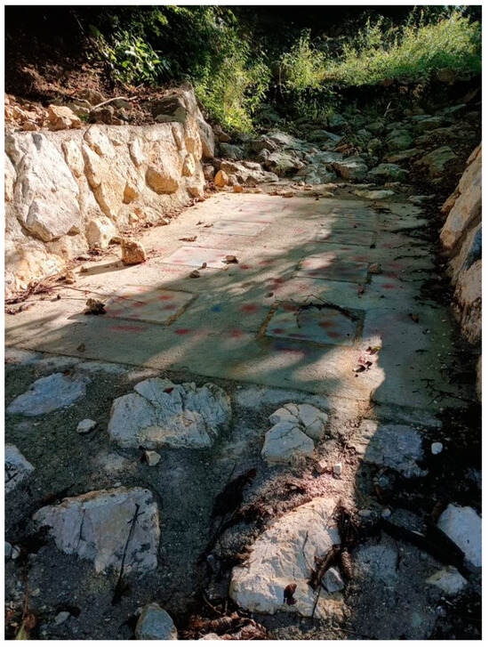 Figure 12. A field test site in the lower Brezovški graben for monitoring concrete abrasion—an upstream view.
3.5. August 2023 Extreme Flood
On 3–4 August 2023, extreme rainfall caused intense erosion processes and mass movements, such as debris flows, slumps and landslide slips, and especially large and devastating floods in many parts of Slovenia [26,27]. The Krvavec meteorological station measured 30 mm in 30 min, 165 mm in 12 h and 196 mm of rainfall in 24 h, and rainfall erosivity for this event was over 1500 MJ × mm × ha−1 × h−1 × year−1—approximately 50% of the mean annual rainfall erosivity for this station and larger than during the previous extreme event (i.e., 2018). The return period of 12 h rainfall amount was estimated to be over 250 years. The 12 h rainfall intensity was also larger than the one associated with empirical rainfall threshold curves for the initiation of shallow landslides and debris flows—e.g., the one proposed by Caine in 1980 [36,37,38]. Hence, numerous smaller landslides, slumps and soil slips occurred in this area, and flexible net barriers were able to retain the eroded material (Figure 13) and stabilize the channel bed without excessive channel incision. Consequently, the cabin car ski lift was not affected, as was the case during the May 2018 event, and no significant damage was caused in this part of the catchment (Figure 13). Based on the field geodetic survey using drones, it was estimated that around 19,000 m3 of material was eroded during the August 2023 event, and the majority of the debris material was trapped by the flexible net barriers.
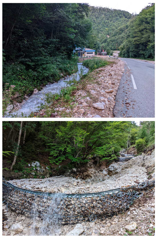
Figure 13.
A situation in both torrents after the extreme August 2023 event.
4. Conclusions
This study presents an overview of torrential hazard mitigation measures used to mitigate the torrential hazards in a typical Alpine catchment in Slovenia based on post-extreme-event surveys and modeling results. The implementation of countermeasures was divided into three phases: (i) channel regulation work in the downstream part of the watershed, (ii) the construction of a large slit check dam with a retention volume of approximately 14,000 m3 for sediment retention, and (iii) the implementation of 16 flexible net barriers with an estimated retention volume of 8000 m3 in both torrents in the upstream part of the watershed. It should be noted that phase (ii) is currently ongoing, while phases (i) and (iii) have already been completed. In the scope of the conducted measures, an extensive monitoring system has also been established that will enable us to explore characteristics of torrential hazards in the future. The monitoring system includes a rain gauge, a video recording system, periodical UAV surveys, Guards®, and a field test site to measure concrete abrasion. The preliminary results have indicated that activity detected by Guards® was caused either by strong wind or heavy rainfall. However, not all thunderstorms caused any torrential erosion activities. Hence, further research is needed to better evaluate the triggering factors of torrential hazards. Field abrasion experiments need more time to be effective since, so far, flexible net barriers have substantially reduced sediment transport over the concrete plates—this will be a rather long-term experiment.
The main scientific and applied contribution of this study is to clearly present and show examples of good practices in sediment management in a typical Alpine catchment that could also be used in other parts of the country. The recent August 2023 flood event has shown that the executed structural (grey) mitigation measures effectively limited excessive sediment erosion and transport from steep torrential channels to downstream areas; they withstood high dynamic loads and, as such, are able to cope with extreme hydro-meteorological events above design discharges determined for a 100-year return period [28]. After the August 2023 event, there was no significant damage to the Krvavec cabin car ski lift (Figure 13)—contrary to substantial damages during the less intense May 2018 event [23]. Also, the rainfall erosivity for the 2023 event was larger than the one for the 2018 event, when there was significant damage at the Krvavec cabin car ski lift ([23]). Therefore, such structural (grey) measures (e.g., flexible net barriers) could be applied in steep torrential catchments in similar geological settings and those that are difficult to access with heavy machinery and hence the construction of torrential concrete check-dams is more challenging.
Supplementary Materials
The following supporting information can be downloaded at: https://www.mdpi.com/article/10.3390/app132011136/s1, Figure S1: Torrential unstable conditions in the Brezovški torrent; Figure S2: Drilling process (left) and steel anchors (right); Figure S3: Construction site in the Brezovški graben torrent; Figure S4: Series of flexible barriers on the Brezovški torrent; Figure S5: Series of flexible barriers on the Brezovški torrent; Figure S6: Maximum 30-m wind speed and rainfall rate for the period of Guard® operation and identification of days when the Guards® detected some activity. Wind speed and rainfall data are obtained from the nearby Krvavec station; Figure S7: Some additional parameters measured by the Guards® during the one-month period; Table S1: Main characteristics of events detected by Guards®. The information about strong winds and storms was obtained from the climatological station at Ljubljana Brnik, while 30-m precipitation and wind speed data were obtained from the nearby meteorological station at Krvavec.
Author Contributions
J.S., M.M. and N.B.: conceptualization, methodology, writing—original draft preparation. All authors have read and agreed to the published version of the manuscript.
Funding
The check dam design and design of other mitigation measures were financed by the Slovenian Water Agency. Geobrugg AG, Romanshorn, Switzerland, supported the installation of the GUARD measuring equipment. The authors’ research work was supported by the Slovenian Research and Innovation Agency (ARIS) through grants P2-0180, J1-3024, J1-2477, J6-4628, and N2-0313.
Institutional Review Board Statement
Not applicable.
Informed Consent Statement
Not applicable.
Data Availability Statement
Not applicable.
Acknowledgments
We would like to acknowledge the Slovenian Environment Agency’s (ARSO) support for making available the hydro-meteorological data. The slit check dam design and the design of other mitigation measures were financed by the Slovenian Water Agency. Geobrugg AG supported the installation of measuring equipment (i.e., Guards).
Conflicts of Interest
The authors declare no conflict of interest.
References
- Bezak, N.; Sodnik, J.; Maček, M.; Jurček, T.; Jež, J.; Peternel, T.; Mikoš, M. Investigation of potential debris flows above the Koroška Bela settlement, NW Slovenia, from hydro-technical and conceptual design perspectives. Landslides 2021, 18, 3891–3906. [Google Scholar] [CrossRef]
- Hilker, N.; Badoux, A.; Hegg, C. The swiss flood and landslide damage database 1972–2007. Nat. Hazards Earth Syst. Sci. 2009, 9, 913–925. [Google Scholar] [CrossRef]
- Bertoldi, G.; D’Agostino, V.; McArdell, B.W. An integrated method for debris flow hazard mapping using 2D runout models. 12th Congr. Interpraevent 2012, 435–446. [Google Scholar]
- De Finis, E.; Gattinoni, P.; Marchi, L.; Scesi, L. Anomalous Alpine fans: From the genesis to the present hazard. Landslides 2018, 15, 683–694. [Google Scholar] [CrossRef]
- Rickenmann, D.; Laigle, D.; McArdell, B.W.; Hübl, J. Comparison of 2D debris-flow simulation models with field events. Comput. Geosci. 2006, 10, 241–264. [Google Scholar] [CrossRef]
- Sikorska, A.E.; Viviroli, D.; Seibert, J. Flood-type classification in mountainous catchments using crisp and fuzzy decision trees. Water Resour. Res. 2015, 51, 7959–7976. [Google Scholar] [CrossRef]
- Andres, N.; Badoux, A. The Swiss flood and landslide damage database: Normalisation and trends. J. Flood Risk Manag. 2019, 12, e12510. [Google Scholar] [CrossRef]
- Rusjan, S.; Kobold, M.; Mikoš, M. Characteristics of the extreme rainfall event and consequent flash floods in W Slovenia in September 2007. Nat. Hazards Earth Syst. Sci. 2009, 9, 947–956. [Google Scholar] [CrossRef]
- Kvočka, D. One-dimensional sediment transport modelling with engelund-hansen and ackers-white transport equations for the lower danube river; [Enodimenzijsko Modeliranje Premeščanja Plavin s Transportnima Enačbama Engelund-Hansen in Ackers-white za Spodnjo Donavo]. Acta Hydrotech. 2021, 34, 103–117. [Google Scholar] [CrossRef]
- Mikoš, M. After 2000 Stože landslide: Part I—Development in landslide research in Slovenia—Po zemeljskem plazu Stože leta 2000: Del I—Razvoj raziskovanja zemeljskih plazov v Sloveniji. Acta Hydrotech. 2020, 33, 129–153. [Google Scholar] [CrossRef]
- Lala, J.M.; Rounce, D.R.; McKinney, D.C. Modeling the glacial lake outburst flood process chain in the Nepal Himalaya: Reassessing Imja Tsho’s hazard. Hydrol. Earth Syst. Sci. 2018, 22, 3721–3737. [Google Scholar] [CrossRef]
- Zscheischler, J.; Westra, S.; Van Den Hurk, B.J.J.M.; Seneviratne, S.I.; Ward, P.J.; Pitman, A.; Aghakouchak, A.; Bresch, D.N.; Leonard, M.; Wahl, T.; et al. Future climate risk from compound events. Nat. Clim. Chang. 2018, 8, 469–477. [Google Scholar] [CrossRef]
- Saez, J.L.; Corona, C.; Stoffel, M.; Berger, F. Climate change increases frequency of shallow spring landslides in the French Alps. Geology 2013, 41, 619–622. [Google Scholar] [CrossRef]
- Viani, C.; Chiarle, M.; Paranunzio, R.; Merlone, A.; Musacchio, C.; Coppa, G.; Nigrelli, G. An integrated approach to investigate climate-driven rockfall occurrence in high alpine slopes: The Bessanese glacial basin, Western Italian Alps. J. Mt. Sci. 2020, 17, 2591–2610. [Google Scholar] [CrossRef]
- Kryžanowski, A.; Brilly, M.; Rusjan, S.; Schnabl, S. Review Article: Structural flood-protection measures referring to several European case studies. Nat. Hazards Earth Syst. Sci. 2014, 14, 135–142. [Google Scholar] [CrossRef]
- Debele, S.E.; Kumar, P.; Sahani, J.; Marti-Cardona, B.; Mickovski, S.B.; Leo, L.S.; Porcù, F.; Bertini, F.; Montesi, D.; Vojinovic, Z.; et al. Nature-based solutions for hydro-meteorological hazards: Revised concepts, classification schemes and databases. Environ. Res. 2019, 179, 108799. [Google Scholar] [CrossRef] [PubMed]
- Nakamura, F. Concept and Application of Green and Hybrid Infrastructure. In Green Infrastructure and Climate Change Adaptation: Function, Implementation and Governance; Nakamura, F., Ed.; Springer: Singapore, 2022; pp. 11–30. ISBN 978-981-16-6791-6. [Google Scholar]
- Alves, A.; Vojinovic, Z.; Kapelan, Z.; Sanchez, A.; Gersonius, B. Exploring trade-offs among the multiple benefits of green-blue-grey infrastructure for urban flood mitigation. Sci. Total Environ. 2020, 703, 134980. [Google Scholar] [CrossRef]
- Kabisch, N.; Frantzeskaki, N.; Pauleit, S.; Naumann, S.; Davis, M.; Artmann, M.; Haase, D.; Knapp, S.; Korn, H.; Stadler, J.; et al. Nature-based solutions to climate change mitigation and adaptation in urban areas: Perspectives on indicators, knowledge gaps, barriers, and opportunities for action. Ecol. Soc. 2016, 21, 39. [Google Scholar] [CrossRef]
- Graf, C.; Christen, M.; McArdell, B.W.; Bartelt, P. An overview of a decade of applied debris-flow runout modeling in Switzerland: Challenges and recommendations. In Proceedings of the Debris-Flow Hazards Mitigation: Mechanics, Monitoring, Modeling, and Assessment—Proceedings of the 7th International Conference on Debris-Flow Hazards Mitigation, Golden, CO, USA, 10–13 June 2019; pp. 685–692. [Google Scholar]
- Peternel, T.; Kumelj, Š.; Oštir, K.; Komac, M. Monitoring the Potoška planina landslide (NW Slovenia) using UAV photogrammetry and tachymetric measurements. Landslides 2017, 14, 395–406. [Google Scholar] [CrossRef]
- Bezak, N.; Jež, J.; Sodnik, J.; Jemec Auflič, M.; Mikoš, M. An extreme May 2018 debris flood case study in northern Slovenia: Analysis, modelling, and mitigation. Landslides 2020, 17, 2373–2383. [Google Scholar] [CrossRef]
- Sodnik, J.; Mikoš, M. The Krvavec bottom cabin lift station protection against torrential hazards by a new slit check dam and a series of flexible net barriers. In Proceedings of the 5th Regional Symposium on Landslides in the Adriatic–Balkan Region (ReSyLAB), Rijeka, Croatia, 23–26 March 2022; pp. 219–224. [Google Scholar]
- Huang, Y.; Zhu, C. Numerical analysis of tsunami–structure interaction using a modified MPS method. Nat. Hazards 2015, 75, 2847–2862. [Google Scholar] [CrossRef]
- Chongqiang, Z.; Zhiyi, C.; Yu, H. Coupled Moving Particle Simulation–Finite-Element Method Analysis of Fluid–Structure Interaction in Geodisasters. Int. J. Geomech. 2021, 21, 4021081. [Google Scholar] [CrossRef]
- ARSO Report about the Extreme Rainfall between 3rd and 6th of August 2023. Available online: https://meteo.arso.gov.si/uploads/probase/www/climate/text/sl/weather_events/padavine_3-6avg2023.pdf (accessed on 25 August 2023).
- Bezak, N.; Panagos, P.; Liakos, L.; Mikoš, M. Brief communication: A first hydrological investigation of extreme August 2023 floods in Slovenia, Europe. EGUsphere 2023, 2023, 1–13. [Google Scholar] [CrossRef]
- Renard, K.G.; Foster, G.R.; Weesies, G.A.; McCool, D.K.; Yoder, D.C. Predicting Soil Erosion by Water: A Guide to Conservation Planning with the Revised Universal Soil Loss Equation (RUSLE); U.S. Department of Agriculture: Washington, DC, USA, 1997.
- USDA Rainfall Intensity Summarization Tool (RIST). Available online: https://www.ars.usda.gov/southeast-area/oxford-ms/national-sedimentation-laboratory/watershed-physical-processes-research/research/rist/rist-rainfall-intensity-summarization-tool/ (accessed on 25 August 2023).
- Panagos, P.; Ballabio, C.; Borrelli, P.; Meusburger, K.; Klik, A.; Rousseva, S.; Tadić, M.P.; Michaelides, S.; Hrabalíková, M.; Olsen, P.; et al. Rainfall erosivity in Europe. Sci. Total Environ. 2015, 511, 801–814. [Google Scholar] [CrossRef]
- Geobrugg. DEBFLOW; Geobrugg: Romanshorn, Switzerland, 2021. [Google Scholar]
- Geobrugg Geobrugg GUARD. Available online: https://www.geobrugg.com/en/Geobrugg-GUARD-157047.html (accessed on 25 August 2023).
- Geobrugg Überwachungsvorrichtung und Verfahren zur Überwachung einer Korrosion eines Drahtnetzes. DE Patent 102017123810 A1, 18 April 2019.
- ASTM C 1138M-05; Standard Test Method for Abrasion Resistance of Concrete (Underwater Method). American Society for Testing and Materials: West Conshohocken, PA, USA, 2006.
- Kryžanowski, A.; Mikoš, M.; Šuštersic, J.; Planinc, I. Abrasion Resistance of Concrete in Hydraulic Structures. ACI Mater. J. 2009, 106, 349–356. [Google Scholar] [CrossRef]
- Caine, N. The rainfall intensity-duration control of shallow landslides and debris flows. Geogr. Ann. Ser. A 1980, 62, 23–27. [Google Scholar] [CrossRef]
- Guzzetti, F.; Peruccacci, S.; Rossi, M.; Stark, C.P. The rainfall intensity-duration control of shallow landslides and debris flows: An update. Landslides 2008, 5, 3–17. [Google Scholar] [CrossRef]
- Rosi, A.; Peternel, T.; Jemec-Auflič, M.; Komac, M.; Segoni, S.; Casagli, N. Rainfall thresholds for rainfall-induced landslides in Slovenia. Landslides 2016, 13, 1571–1577. [Google Scholar] [CrossRef]
Disclaimer/Publisher’s Note: The statements, opinions and data contained in all publications are solely those of the individual author(s) and contributor(s) and not of MDPI and/or the editor(s). MDPI and/or the editor(s) disclaim responsibility for any injury to people or property resulting from any ideas, methods, instructions or products referred to in the content. |
© 2023 by the authors. Licensee MDPI, Basel, Switzerland. This article is an open access article distributed under the terms and conditions of the Creative Commons Attribution (CC BY) license (https://creativecommons.org/licenses/by/4.0/).