Article

Drone Magnetic and Time Domain Electromagnetic Exploration in Metamorphic Formations: Tool for the Identification of Strategic Sites for Aquifer Exploitation

by
Javier Carrasco García
1,
Pedro Carrasco García
2,*,
Daniel Porras Sanchiz
3,
Ignacio Martín Nieto
2,
Cristina Sáez Blázquez
2 and
Pedro Huerta Hurtado
2
1
Técnicas Geofísicas S.L., 05003 Avila, Spain
2
Department of Cartographic and Land Engineering, Higher Polytechnic School of Avila, University of Salamanca, Hornos Caleros 50, 05003 Avila, Spain
3
Geoland Services S.L., 28008 Madrid, Spain
*
Author to whom correspondence should be addressed.
Appl. Sci. 2023, 13(19), 10949; https://doi.org/10.3390/app131910949
Submission received: 9 September 2023 / Revised: 25 September 2023 / Accepted: 30 September 2023 / Published: 4 October 2023
(This article belongs to the Special Issue Integration of Methods in Applied Geophysics, Volume II)

Abstract

:
In the contemporary era, the exploitation of aquifers in the agricultural sector has become increasingly important. In response, researchers have directed their efforts towards the formulation of effective methodologies, with geophysical prospecting emerging as a fundamental tool in locating the best underground deposits. The magnetic prospecting technique can discriminate between different categories of rocks, which facilitates the localisation of geological contacts—an essential factor in determining the strategic location of boreholes, while electromagnetic time-domain prospecting helps in the definition of sedimentary strata. In particular, this process reveals the important influence of tertiary and metamorphic formations on the regional hydrogeological framework of the studied area. The variable yields recorded in the wells in the area that have yielded good results are a clear indication of the presence of aquifers. However, it is important to note that numerous wells have been drilled in this region that have yielded negligible or even zero flow rates. Prudent selection of the location and depth of boreholes is essential to ensure proper management of this resource. The use of drones equipped with magnetometers is essential to speed up the spatial mapping process. Empirical results corroborate the accurate classification of lithological units, thus facilitating the selection of sites for groundwater abstraction. These studies serve to validate initial hypotheses and profoundly enrich our understanding of the hydrogeological dynamics of the site, thus providing avenues for optimal and sustainable exploitation and future academic research.

1. Introduction

In the 21st century, the exploitation of aquifers has become one of the main objectives of the agricultural sector, both to expand and improve existing farms. This growing trend has sparked a keen interest among researchers, who are focused on finding different methods to address this issue in different geological contexts [1,2,3,4,5,6].
Currently, the techniques used, such as geophysics, require considerable physical effort and face difficulties of access due to topography or vegetation. Therefore, one of the main concerns among geophysicists is the need to adopt methods that are more convenient, faster and able to cover larger areas.
In this paper, we propose an advanced methodology for the effective characterisation of geological strata. We focus in particular on the application of electromagnetic soundings in order to deepen the understanding of the Tertiary strata located in the study region. These soundings are presented as a valuable complement to magnetometry techniques. We also integrate the use of unmanned aerial vehicles (drones) as an essential component in the generation of detailed mapping of the metamorphic materials found in this research area.
In general, metamorphic materials tend to be aquifers with low levels of permeability, making them difficult to exploit. In many cases, they are hardly viable for use. To obtain more interesting flow rates, it is necessary to locate fracture zones or contacts between different materials [7,8,9]. In this sense, the mapping of the area by means of magnetic prospecting is of great help in the strategic location of these boreholes.
Indeed, magnetic surveying has the ability to differentiate between different types of metamorphic rocks, a feature that can be difficult to achieve using other geophysical variables. This distinguishing ability makes magnetic surveying a valuable tool for the characterisation and detailed study of metamorphic formations, which in turn helps to improve accuracy in the identification of potential aquifers and areas of interest for exploitation [10].

2. Geological and Hydrogeological Context

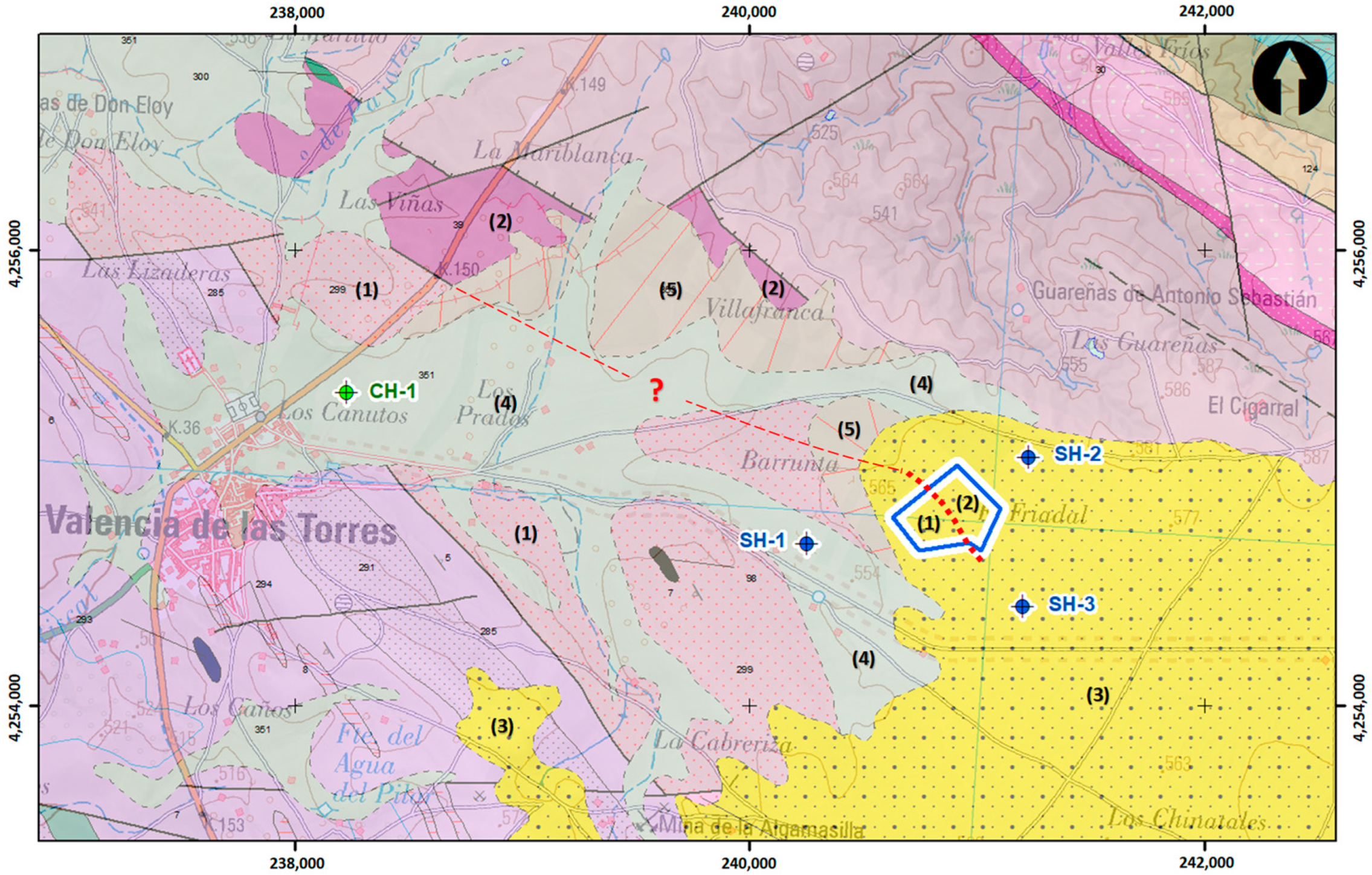
2.1. Geological Context

The region between the Sierra Albarrana and Obejo-Valsequillo-Puebla de la Reina domains hosts metamorphic materials with a dynamothermal evolution that differs markedly from the rest of the area. These rocks are delimited by large-scale longitudinal faults and include a varied range of formations, including volcanic, detrital and granitic materials of Carboniferous and Tertiary–Quaternary age.
In this geographical area (Figure 1), two distinct groups of metamorphic rocks have been identified: The Higuera de Llerena-Hinojosa del Valle Group and the Atalaya Group. These groups represent a significant geological unit that has been the subject of extensive research due to their unique evolution and composition. The presence of these metamorphic rocks, together with the specific tectonic configuration of the area, makes this place an exciting field of study to deepen the understanding of the geological processes that have shaped this region [11].
The study area is located in the Higuera de Llerena-Hinojosa del Valle Group. Here, different types of metamorphic rocks can be identified. On the one hand, there are metagranites, quartz schists and/or ultramylonites (Formation 1). These metamorphic rocks have a schistose appearance and are mainly composed of minerals such as quartz, feldspar and a pelitic matrix.
On the other hand, in the same area, there are also orthogneisses (Formation 2) that have their origin in granites, tuffs or acid volcanic rocks. These orthogneisses are rocks that have undergone a process of metamorphism and are characterised by a distinctive texture and composition.
The presence of this diversity of metamorphic rocks in the study area offers a valuable opportunity to investigate and understand the geological processes that have been at work in this region, as well as to analyse the transformations and evolution that these formations have undergone over time.
In the upper part of these materials is a Tertiary formation (Formation 3) that is mainly composed of siltstones and argillites, which originated from the decalcification of limestone outcrops. Towards the base of this tertiary formation, levels of sandstones and conglomerates with calcareous cement are observed.
This set of Tertiary formations adds an additional layer of geological interest in the study area. The process of limestone decalcification and the subsequent deposition of siltstones and argillites have contributed to the present configuration of the area, while the presence of sandstones and conglomerates with calcareous cement provides valuable information on the sedimentary and paleoenvironmental conditions that prevailed during their formation.
In the vicinity of the municipality of Valencia de las Torres, there is an interesting alluvial formation (Formation 4). This formation is characterised by thick deposits found in rivers and flood plains. These deposits are mainly composed of quartzite gravels and sand.
In addition to this, in the areas with steeper relief near Valencia de las Torres, colluvial deposits and alluvial soils can be observed (Formation 5). These colluvial deposits and alluvial soils are interpreted as the result of the accumulation of materials from the erosion of Plio–Quaternary materials in the region. It is important to highlight that, in these areas, the influence of human activities has played a relevant role in the configuration of these deposits.
Although bibliographical data exists on the geology of the area, there are still unknowns regarding the arrangement of the metamorphic rocks in the areas of Tertiary and Quaternary cover. These unknowns add a level of intrigue to the understanding of the geological history of the region, and this is an area where continued research can provide valuable insights into the geological evolution of Valencia de las Torres and the surrounding area.

2.2. Hydrogeological Context

In the research area, Precambrian and Palaeozoic terrains are mostly impermeable, with the exception of Cambrian limestone outcrops, which have the capacity to store significant amounts of water. Highly competent rocks can also act as good aquifers if they are highly fractured. However, most other materials present very little potential as aquifers from a general point of view. Only small water uptakes can be expected, especially in areas where fracture zones exist or in areas that have undergone high geological alteration.
In summary, the region has limited availability of significant aquifers, with the most significant being Cambrian limestone outcrops and highly fractured rocks. It is important to take these geological characteristics into account when approaching any water resource exploitation project in the area.
Tertiary and/or quaternary deposits are materials that are characterised by their crumbly nature, i.e., their composition is brittle and easily eroded. These materials are deposited or formed on an impermeable substrate, resulting in what is known as a hanging deposit. These deposits, being on an impermeable base, allow water to flow into the existing streams in the area. This situation is clearly perceptible, and a series of springs can be identified at the same level, indicating the level of contact between these materials and the impermeable substrate.
Water abstractions in these reservoirs tend to be quite shallow, generally with depths ranging from 0 to 20 m. The flows obtained from these catchments tend to be moderate, as the permeable nature of the reservoirs does not allow for the accumulation of large volumes of water.
It is very interesting to know that in the surroundings of the study area, there is a borehole catalogued by the Guadiana Hydrographic Confederation (CH-1). This borehole represents a valuable source of information on the availability and quality of water in the region. The cataloguing by the confederation indicates that these boreholes have been subject to rigorous monitoring and analysis, which provides a reliable database for the hydrogeological study and sustainable management of water resources in the area.
We are thankful for the information provided on the borehole present in the study area. According to the data provided, this borehole has a depth of approximately 50 m, while the water level is around 10 m. The recorded flow rates are 11 L/s. It is important to note that the lithology of the borehole is composed of metagranites, quartz schists and/or ultramylonites, according to the data provided by the data platform [12].
This information is relevant for the hydrogeological analysis of the region, as it indicates the existence of aquifers in the area. The depth of the boreholes suggests that the groundwater is at an accessible distance, which may favour its use by means of appropriate extraction techniques.
Variable flows are indicative of the dynamics of groundwater flow, which can be influenced by various factors such as seasonality and local hydrological characteristics. These moderate flows represent a significant source of water, which can satisfy various water requirements, provided they are managed in a responsible and sustainable manner.
The presence of metagranites, quartz schists and/or ultramylonites in the borehole is relevant, as these metamorphic rocks have the capacity to contain and transport groundwater. These lithological characteristics offer promising potential as natural aquifers in the region.
It is relevant to mention that, in addition to the boreholes catalogued by official bodies, additional research was carried out in boreholes close to the study area carried out by private individuals. These boreholes are not officially registered, which means that it is not possible to be absolutely certain about the quality and reliability of their data.
Nevertheless, the information obtained through this research is valuable, as it sheds light on the existence of SH-1 flows of 2–2.5 L/s, SH-2 of 1–1.5 L/s and SH-3 of 1 L/s. The variability in flow rates points to the natural dynamics of groundwater flow in the area, which may be influenced by different hydrological and geological factors. In addition, it is important to note that numerous boreholes have been drilled in this region that have yielded negligible or even zero flow rates.
In conclusion, we can see that, in general, the flow rate of the boreholes depends on the metamorphic formation in which they are located, ignoring the small tertiary cover of no more than 20 m in some cases. It should be noted that the supply borehole (CH-1) is located on a Quaternary formation which the rest do not have, in addition to the Tertiary, which may indicate a thickening of the thickness of this formation and be the factor for this increase in flow. For our assessment we will not take this borehole into account, as it yields data that are probably not consistent with the metamorphic rocks.

3. Materials and Methods

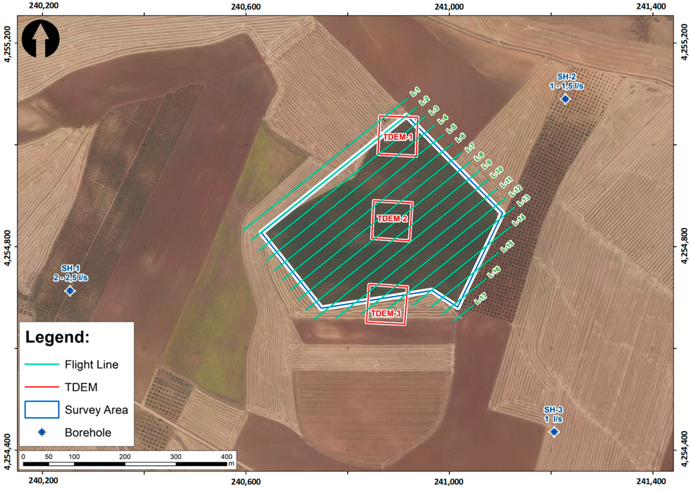
3.1. Site Conditions

The data used in this study were collected during the spring of 2020, on a day that was partly cloudy but mostly sunny. During data collection, the temperature remained at a pleasant average of 19 degrees Celsius, while wind speed remained constant at 5 m per second. The location is characterised by spring weather, with average temperatures varying between 20 and 30 degrees Celsius, and wind speeds generally below 5 m per second. These climatic conditions favoured data acquisition and ensured the accuracy of the results.
The study was carried out over a three-hour period in a large rain-fed agricultural area. In this area the presence of trees is scarce, except in the plots located to the east, which contain vineyards and olive groves that were not the subject of our analysis. The topography of the region shows minimal variations, with a difference of less than 2 m from north to south, making it gentle and practically flat. This topography provided optimal conditions for data collection, greatly simplifying our research.
To mitigate possible risks (although they were not considered particularly relevant in our study area, such as collisions of the drone with topographic elements or vegetation), a digital elevation model (DEM) of the area was previously elaborated. In this flight the most essential geometric criteria for photogrammetric applications [13] were applied, which guaranteed the obtaining of high-quality cartographic data and a Ground Sampling Resolution (GSD) of 4 centim per pixel.
DEM generation was carried out using a DJI Mavic 2 Pro drone equipped with a 1-inch CMOS sensor, flying at an altitude of 150 m above ground level (AGL). This approach ensured a stable and safe flight, which allowed us to obtain accurate and reliable results for our research.
In addition, a short electromagnetic sounding campaign was conducted to assess the possible thickness of the Tertiary strata [14,15]. This campaign consisted of three electromagnetic soundings arranged in a 75 × 75 m profile.

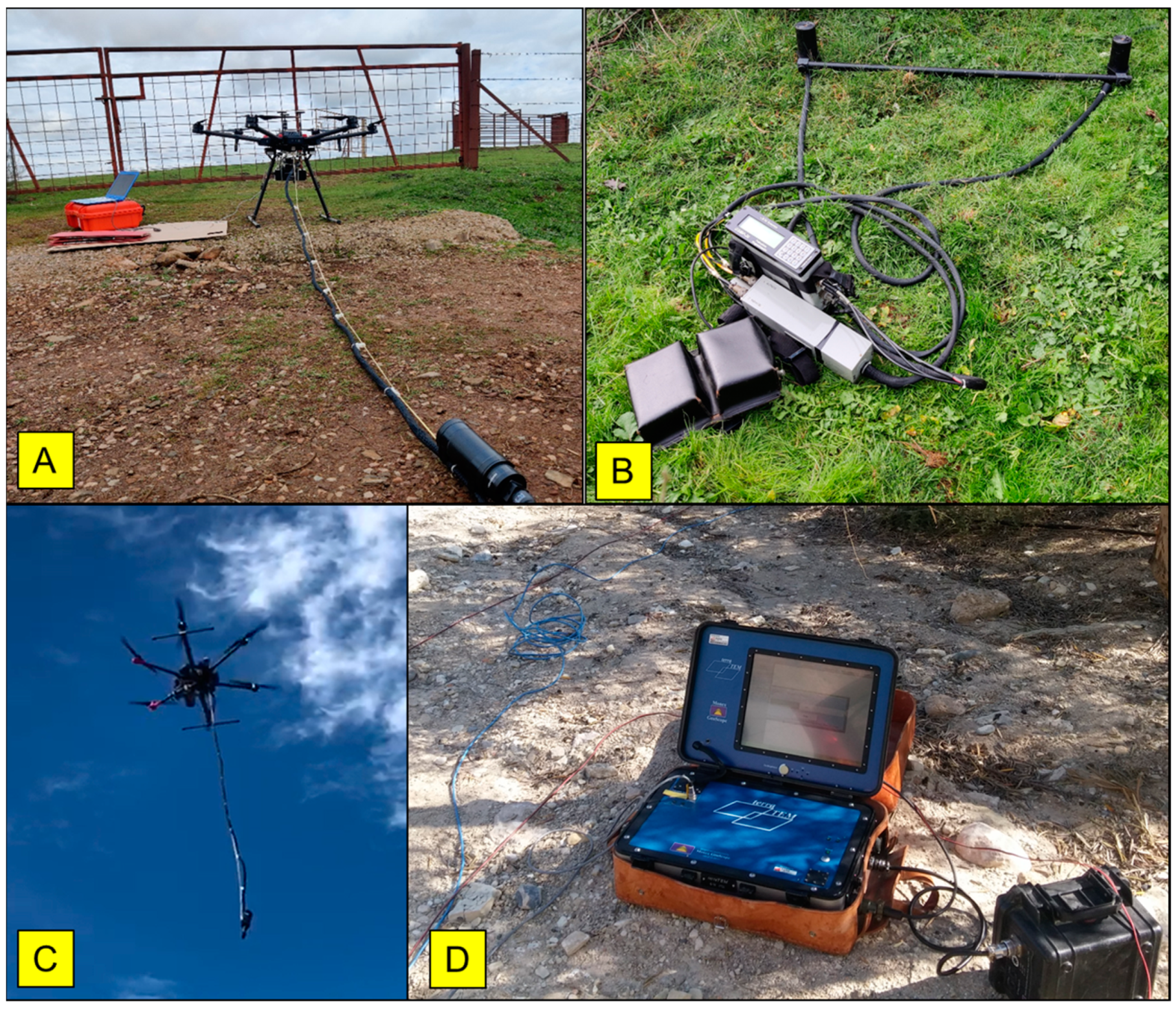
3.2. Platform and Flight Planning

In the current study, the Dji Matrice 600 Pro multi-rotor hexacopter was used (Figure 2), which has an A3Pro flight controller and is compatible with UgCS mission planning software. This device has a total take-off weight of 9.6 kg and a maximum payload capacity of 6 kg, and is powered by 6 lithium polymer batteries with a capacity of 4500 mAh.
The flight speed was set at 5 m per second, with a sampling interval of 200 milliseconds, allowing measurements to be taken at one-metre intervals along the recorded profile. A flight altitude of 20 m above ground level (AGL) was selected to maximise sensor resolution and ensure safety from potential obstacles. In addition, the previously acquired digital elevation model was incorporated into the flight plan. Finally, a tolerance level of 1 m was defined for altitude adjustments during the flight.
The design and control of the project was carried out using UgCS flight software. Seven parallel survey lines of varying lengths were implemented, oriented in a N45E direction and perpendicular to the regional geological structure. A distance of 25 m was maintained between each line to achieve high spatial resolution and to capture variations in the target magnetic field (Figure 3). Given the vastness of the study area, the total flight was divided into two blocks, choosing a take-off and landing point considering the capabilities of the batteries.
The resulting effect of the separation between the sensor and the surface leads to a slight reduction in spatial resolution and intensity, in contrast to ground-based investigations [16,17]. However, this decrease is compensated by a constant and higher density data acquisition.

3.3. Magnetometry

The drone was equipped with a GEM-Systems GSMP-35U potassium vapour mag-netometer, which has a sensitivity of 0.0002 nT/1 Hz. This system also has the capability to simultaneously record the magnetic field and to incorporate a real-time single-frequency (L1) GPS receiver.
This equipment consists of multiple components, including a sensor connected by cable to a controller, a data logger, a 5 V battery power supply and a GPS receiver, with a total weight not exceeding 2 kg. To ensure the stability and safety of the system, careful adjustments were made to locate and balance the data logger and batteries inside the drone’s cargo compartment. In addition, the GPS antenna was placed on top of the drone to ensure continuous signal reception.
Regarding the accuracy of the magnetic sensor, it is important to note that interference from vegetation, topography, soil moisture and rock features is negligible. However, it is crucial to keep in mind that topography plays a decisive and essential role in the generation of the three-dimensional (3D) model.
Due to the presence of magnetic interference generated by the electromagnetic motors inside the drone platform, significant measures were implemented to counteract this effect [18,19]. The magnetic sensor was placed at a distance of 3 m from the base of the drone and connected to the main system via a cable. This strategic arrangement allowed the influence of the magnetic field produced by the motors to be minimised, preventing it from affecting the measurements made by the GSMP-35U magnetometer [20].
To prevent pendulum motion of the sensor, which could cause variations in roll, pitch and yaw axes, additional 25 m segments were added at each end of the flight lines during 180-degree turns. This approach allowed greater leeway and reduced the likelihood of sudden or unexpected movements affecting the measurements.
The installation of the magnetic sensor was carried out without rotation restrictions on any of the axes, which provided greater freedom of movement during operations. Specific measures were implemented in the project design to ensure the accuracy of the measurements and minimise any possible interference.
In addition, the flight speed was reduced, which contributed to a more stable and controlled operation. The lower speed facilitated better control of the drone, which in turn helped to minimise unwanted sensor oscillations.
Simultaneously, a fixed magnetometer was installed in a nearby location free from sources of magnetic interference. Its purpose was to calculate the correction for the diurnal effect, which occurs due to the temporal variation of the magnetic field throughout the day (Figure 2B).
The fixed magnetometer was set up with a total field recording interval of 1 s.

3.4. TDEM

A series of 75 × 75 m electromagnetic soundings were carried out using a “coincident loop” type measuring device. Data were acquired using Terra-Tem equipment designed by Monex GeoScope (Figure 2D).
Time domain electromagnetic surveying (TEDM) is performed by introducing a constant current into a closed circuit or transmitter coil (Tx). This action gives rise to a constant primary magnetic field. Then, when the current flowing through the transmitter coil (Tx) is abruptly interrupted, the previously constant primary magnetic field begins to decay gradually over time.
Following the principles of Faraday’s Law, when a body is exposed to a time-varying magnetic field, electric currents are generated in the subsurface. These currents follow closed paths underground, moving both in depth and laterally. Over time, the strength of these currents decreases, giving rise to a transient secondary magnetic field that also vanishes at the surface.
This secondary magnetic field induces a temporary variation in the voltage within the receiver circuit (Rx). The way this voltage decreases provides valuable information about the resistivity of the subsurface. Both the magnitude and the distribution of the induced currents are closely related to the resistivity properties of the medium. It is important to note that this process is depth–migratory, which implies that short duration stresses provide information about the resistivity of the shallow layers, while longer duration stresses provide knowledge about the resistivity of the deeper layers of the subsurface [21,22,23].

3.5. Data Processing

The magnetometry data were processed using OASIS Montaj 9.8 software, using conventional methods to calculate anomalies and produce residual anomaly maps through a variety of filters. In an initial phase, inaccurate values resulting from drone position, take-off and landing manoeuvres, orientation, excessive roll and temporal discrepancies between the sensor and the drone were filtered out. Points located at the most extreme extensions of the survey lines and other outliers were excluded using a one-dimensional median filter. Finally, a correction using the diurnal variation of the Earth’s magnetic field values, caused by solar activity, was applied to adjust the data collected during the study period [24].
Regarding the TDEM data, they were acquired using a “coincident loop” configuration and square loops (both emitter and receiver) of 75 m length per side. A minimum of 1000 measurement repetitions per channel were performed, and tests were carried out at different gain levels in order to minimise any influence of electromagnetic noise present in the environment. The results of the various decay curves obtained in the field were presented using the Monex GeoScope “TEM Plotting Program v 2.0.0”. In addition, the same program was used to generate the corresponding geoelectric profile [25].

4. Results

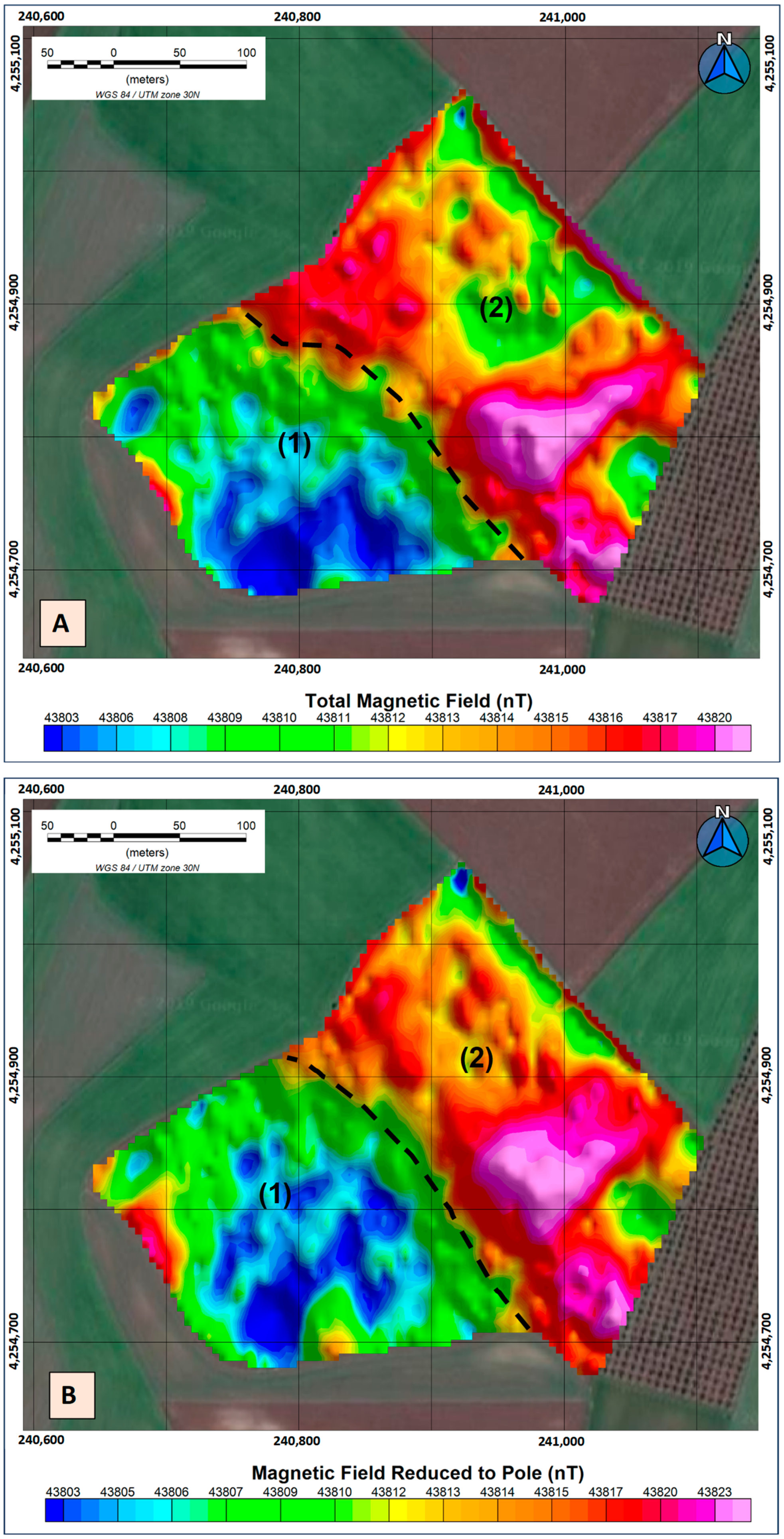
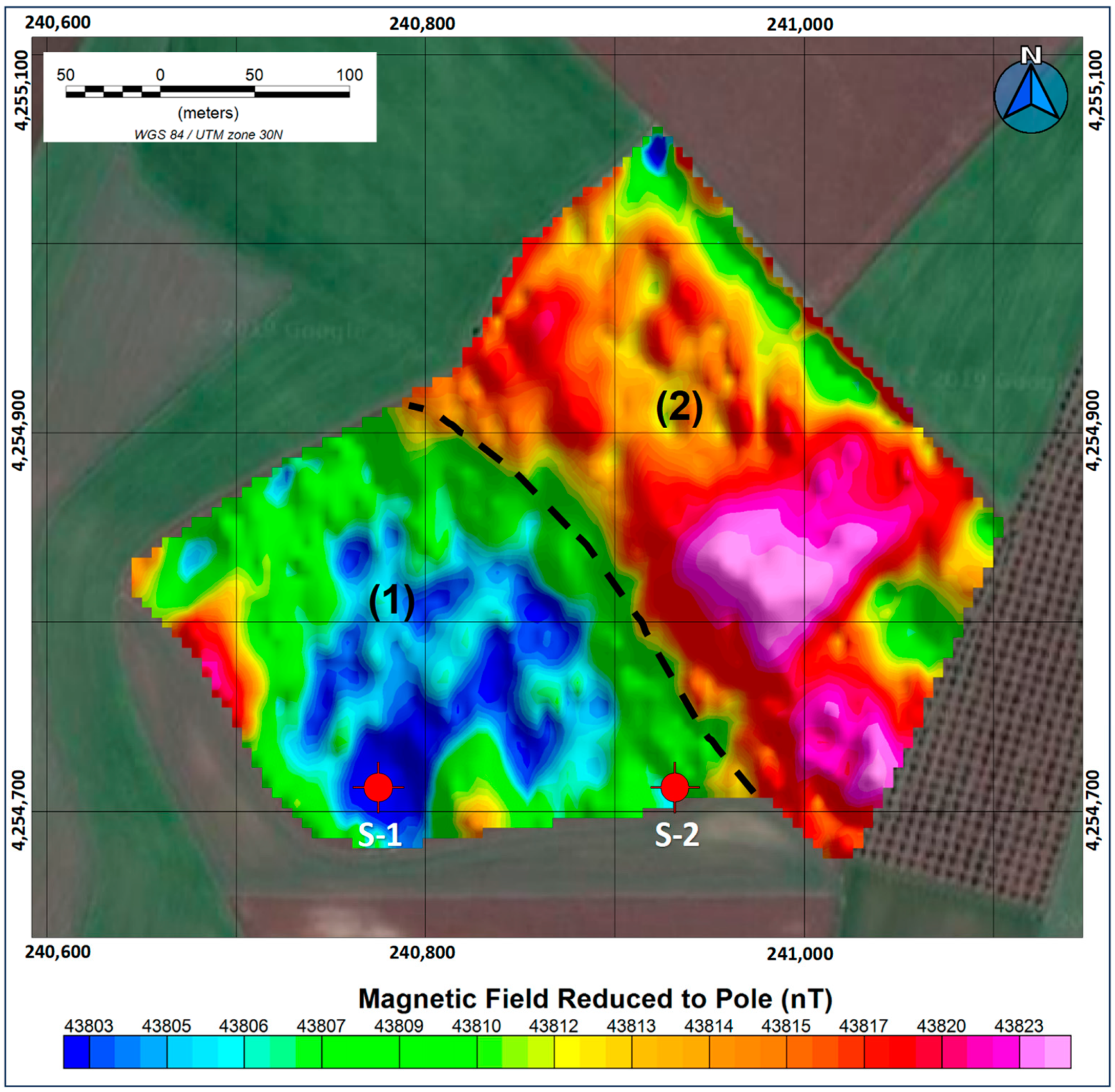
4.1. Total Magnetic Field and Reduction to Pole

The data interpretation process starts with the calculation of the Total Magnetic Field (TMF) from the filtered records (Figure 4A), followed by the application of the Reduction to Pole (RP). By combining the magnetic inclination and declination data in the sampling area, together with the use of the International Geomagnetic Model Reference Magnetic Field (IGRF), it is possible to obtain a direct representation of the primary magnetic sources responsible for the generating bodies (Figure 4B) [26,27].
By examining both representations, a variation in the magnetic field that delimits the study area into two distinct formations stands out. Formation 1 is composed of metagranites, quartz schists and/or ultramylonites (target formation), while Formation 2 corresponds to orthogneisses (very impermeable formation with low hydrogeological possibilities).
The results reveal a disparity of up to 20 nT in the magnetic field between these two geological structures. Interpretation of these data suggests that the lower magnetic field values are linked to the metagranites, quartz schists and/or ultramylonites that make up Formation 1 due to their lower magnetic propensity, compared to the orthogneisses of Formation 2. [28,29] This conclusion is strengthened by the location of nearby drill holes, which indicate a higher permeability in Formation 1.
A critical aspect is the precise identification of the contact point between these two geological structures. The proximity to this transition zone is crucial, as a decrease in flow is anticipated due to the limited aquifer capacity of Formation 2.
This analysis provides valuable information to guide decisions in planning the exploitation of groundwater resources. This enables a more informed choice in the selection of sites for well drilling and a deeper understanding of the local hydrogeology, thus enriching the knowledge base for sustainable groundwater resources management.

4.2. D Inversion Model
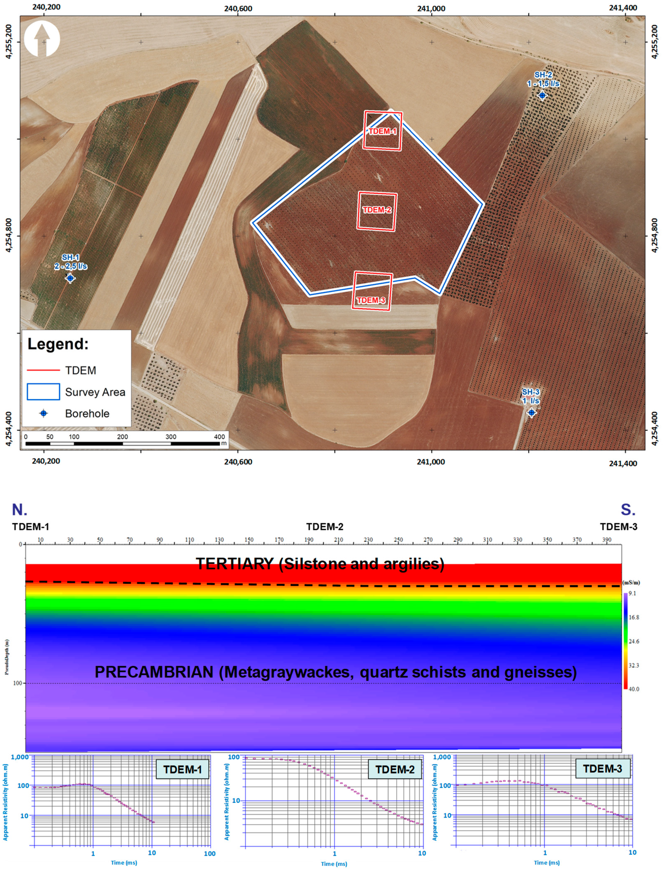
The generation of a high-resolution uniform grid using drones has enabled the creation of three-dimensional models that visualize the magnetic susceptibility by applying an advanced inversion technique [30]. The resulting model has been built using the VOXI Earth Modelling software from OASIS Montaj. This tool has greatly simplified the identification and spatial delimitation of the magnetic bodies of interest.
The results obtained from this modelling process (Figure 5) show the existence of two geological bodies with contrasting magnetic susceptibilities. These findings are of great relevance for the discrimination of the different geological formations present in the study region. It is noteworthy that the lowest magnetic susceptibility corresponds to Formation 1, while the highest susceptibility is associated with Formation 2. It is noteworthy that the metagranites, quartz schists and/or ultramylonites exhibit a markedly lower iron content compared to the orthogneisses, which is essential for the accurate interpretation of our geological model. Moreover, this distinction manifests itself continuously as one goes deeper into the subsurface.

4.3. TDEM

Three electromagnetic soundings (Figure 6) were carried out to acquire information about the Tertiary stratum in order to gain a more precise understanding of the geological column present in our investigation. These tests reveal a more conductive portion corresponding to the Tertiary stratum, followed by an abrupt transition to a more resistive material of a rocky nature, although no changes in it are discernible as anticipated [31,32].
These results show a limited thickness in the Tertiary stratum, which lacks sufficient entity to be considered an aquifer. Moreover, its composition is made up of materials of little hydrogeological interest.
As for the contact between the Precambrian formations, it is not possible to determine its position by TEDM or any other geophysical method from which the resistivity parameter is obtained, given the lack of resistivity contrast between the Precambrian formations present.

4.4. Geological Interpretation, Site Location and Drilling Results

TDEM tests in our study area have yielded results consistent with the presence of a Tertiary cover, as shown in the geological map of the area. However, the configuration of the contact between the Precambrian formations remains an unresolved enigma.
Fortunately, thanks to the application of magnetic investigation techniques, we have been able to identify the point of contact between the formations below the Tertiary layer. This contact is clearly and distinctly in the northwest direction, as can be seen on the geological map. By superimposing our findings on the map, together with a precise extrapolation of this contact point, we have managed to visualise how it aligns relatively coherently with the previously determined trajectory of this particular contact. This interesting result can be seen in Figure 7.
This breakthrough represents a significant step forward in our understanding of the geological layout of the area. By linking the magnetic data with existing geological mapping, we have been able to infer the location of the contact between strata in the subsurface, providing valuable information for the characterisation of the region studied.
Using these results and the information gathered from boreholes, we can propose sites for exploitation of the aquifer of greatest interest (Figure 8).
The selection of drilling sites is based on two main criteria supported by magnetic scanning data, while electromagnetic (TDEM) data were not useful in this respect. These criteria focus on the most favourable lithology (S-1) and the point of contact between geological formations, which could indicate a more fractured zone (S-2).
It is important to note that the location of borehole S-1 is determined on the basis of the lower magnetic susceptibility recorded in the results, looking for a greater presence of material of higher permeability. On the other hand, borehole S-2 is located in the contact zone between both geological formations, but within the formation of greatest interest.
In relation to borehole S-1, the data collected indicate an estimated flow rate of around 2–3 L per second (L/s), which coincides with nearby boreholes and previous boreholes drilled in the same geological formation. As for borehole S-2, due to its location between two formations and its greater degree of alteration, the estimate of the flow rate is less certain, although its proximity to an impermeable edge suggests a lower estimate than in the previous borehole.
Both boreholes (Figure 9) were drilled to a depth of 100 m in both cases, revealing an approximate flow rate of 3 L/s in borehole S-1 and 2 L/s in borehole S-2. These data, although requiring careful consideration due to the absence of regular testing throughout different seasons of the year, provide valuable context to support our site selection hypotheses and rationale.
The higher flow rate recorded in borehole S-1 supports the initial assumption of higher permeability at this location. On the other hand, the lower flow rate obtained in borehole S-2 evidences the nature of the contact between both formations. In addition, it is relevant to note that the material drilled in borehole S-1 was mostly identified as greywackes, whereas borehole S-2 passed through an alteration zone composed of quartz schists, greywackes and ultramylonites.

5. Conclusions

The findings of this current study, based on the application of magnetometric technology using drones to map metamorphic formations for the purpose of identifying locations suitable for drilling groundwater extraction wells, constitute an immensely valuable tool that effectively and rapidly facilitates the mapping of lithological variations in the terrain. In addition, it should be noted that the application of airborne methods enables us to explore much larger geographical areas in significantly reduced time intervals. These methods are particularly effective in the analysis of areas that are difficult to access, either due to complex topographic conditions or dense vegetation, while minimising the physical effort compared to traditional geophysical techniques. The synergy of these elements leads to significant economic savings in the investigation of large areas.
In this specific investigation, it has been possible to distinguish precisely between the different types of materials present, such as orthogneisses, metagranites, quartz schists and ultramylonites. This detailed mapping, which shows the spatial arrangement of these materials, is of considerable importance in the process of selecting and locating extraction pits. This is achieved by proposing the identification of the materials with the highest water potential, as well as the location of contact points between the geological strata. In addition, it is noteworthy that this technology also allows the detection of fractured zones in other types of geological materials.
It is particularly significant to highlight the results obtained by magnetic investigation under a tertiary layer, which was an uncertainty from a bibliographical point of view, and which we have had the opportunity to verify effectively.
It is relevant to underline that the results obtained, presented in their direct form, have contributed substantially to the confirmation of our previous hypotheses, thus enriching our understanding of the hydrogeological behaviour of the studied environment. These findings have not only validated our initial theories, but have also opened new perspectives to broaden our knowledge in this particular field.

Author Contributions

Conceptualization, J.C.G. and P.C.G.; methodology, J.C.G., P.C.G. and D.P.S.; validation, I.M.N., P.C.G., P.H.H. and C.S.B.; formal analysis, P.C.G. and J.C.G.; investigation, J.C.G. and P.C.G.; resources, P.C.G. and J.C.G.; software, P.C.G., D.P.S. and J.C.G.; data curation, J.C.G.; writing—original draft preparation, J.C.G. and D.P.S.; writing—review and editing, P.C.G., D.P.S., I.M.N., P.H.H. and C.S.B.; visualization, I.M.N., P.C.G., C.S.B. and P.H.H.; supervision, P.C.G., P.H.H., I.M.N. and C.S.B.; project administration, P.C.G. and J.C.G. All authors have read and agreed to the published version of the manuscript.

Funding

This research received no external funding.

Institutional Review Board Statement

Not applicable.

Informed Consent Statement

Not applicable.

Data Availability Statement

Not available.

Conflicts of Interest

The authors declare no conflict of interest.

References

  1. D’Odorico, P.; Chicarelli, D.D.; Rosa, L.; Bini, A.; Zilberman, D.; Rulli, M.C. The global value of water in agriculture. Proc. Natl. Acad. Sci. USA 2020, 117, 21985–21993. [Google Scholar] [CrossRef] [PubMed]
  2. Basso, B.; Kendall, A.D.; Hyndman, D.W. The future of agriculture over the Ogallala Aquifer: Solutions to grow crops more efficiently with limited water. Earth’s Future 2013, 1, 39–41. [Google Scholar] [CrossRef]
  3. Smidt, S.J.; Haacker, E.M.K.; Kendall, A.D.; Deines, J.M.; Pei, L.; Cotterman, K.A.; Li, H.; Liu, X.; Basso, B.; Hyndman, D.W. Complex water management in modern agriculture: Trends in the water-energy-food nexus over the High Plains Aquifer. Sci. Total Environ. 2016, 566–567, 988–1001. [Google Scholar] [CrossRef] [PubMed]
  4. Othman, A.; Sultan, M.; Becker, R.; Alsefry, S.; Alharbi, T.; Gebremichael, E.; Alharbi, H.; Abdelmohsen, K. Use of Geophysical and Remote Sensing Data for Assessment of Aquifer Depletion and Related Land Deformation. Surv. Geophys. 2018, 39, 543–566. [Google Scholar] [CrossRef]
  5. Calderón Palma, H.; Bentley, L.R. A regional-scale groundwater flow model for the Leon-Chinandega aquifer, Nicaragua. Hydrogeol. J. 2007, 15, 1457–1472. [Google Scholar] [CrossRef]
  6. Rad, M.R.; Brozovic, N.; Foster, T.; Mieno, T. Effects of instantaneous groundwater availability on irrigated agriculture and implications for aquifer management. Resour. Energy Econ. 2020, 59, 101129. [Google Scholar] [CrossRef]
  7. Ofterdinger, U.; MacDonald, A.M.; Comte, J.C.; Young, M.E. Groundwater in fractured bedrock environments: Managing catchment and subsurface resources- an introduction. Geol. Soc. Lond. Spec. Publ. 2019, 479, 1–9. [Google Scholar] [CrossRef]
  8. Font Capó, J.; Vázquez Suñe, E.; Carrera, J.; Herms, I. Groundwater characterization of a heterogenous granitic rock massif for shallow tunneling. Geol. Acta Int. Earth Sci. J. 2012, 10, 395–408. Available online: https://dialnet.unirioja.es/servlet/articulo?codigo=4138023 (accessed on 17 August 2023).
  9. Gobashy, M.M.; Metwally, A.M.; Abdelazeem, M.; Soliman, K.S.; Abdelhalim, A. Geophysical Exploration of Shallow Groundwater Aquifers in Arid Regions: A Case Study of Siwa Oasis, Egypt. Nat. Resour. Res. 2021, 30, 3355–3384. [Google Scholar] [CrossRef]
  10. Nabighian, M.N.; Grauch, V.J.S.; Hansen, R.O.; LaFehr, T.R.; Li, Y.; Peirce, J.W.; Phillips, J.D.; Ruder, M.E. The historical development of the magnetic method in exploration. Geophysics 2005, 70, 33–61. [Google Scholar] [CrossRef]
  11. IGME MAGNA. Geological and Mining Institute of Spain (IGME). Hoja de Usagre (855). In Mapa Geológico de España (E. 1:50.000); Servicio de Publicaciones del Ministerio de Industria y Energía: Madrid, Spain, 1981. [Google Scholar]
  12. BD Puntos de Agua v2.0 IGME. Available online: https://info.igme.es/BDAguas/ (accessed on 19 August 2023).
  13. Hernandez-Lopez, D.; Felipe-Garcia, B.; Gonzalez-Aguilera, D.; Arias-Perez, B. An automatic approach to UAV flight planning and control for photogrammetric applications. Am. Soc. Photogramm. Remote Sens. 2013, 1, 87–98. [Google Scholar] [CrossRef]
  14. Elwaheidi, M. Geophysical Imaging of a Buried Tertiary Valley Aquifer in an Arid Region Using Time Domain Electromagnetic Method. J. Geosci. Environ. 2020, 8, 195–206. [Google Scholar] [CrossRef]
  15. Hamada, L.R.; Porsani, J.L.; Bortolozo, C.A.; Rangel, R.C. TDEM and VES soundings applied to a hydrogeological study in the central region of the Taubaté Basin, Brazil. First Break 2018, 36, 49–54. [Google Scholar] [CrossRef]
  16. Cunningham, M.; Samson, C.; Wood, A.; Cook, I. Aeromagnetic Surveying with a Rotary-Wing Unmanned Aircraft System: A Case Study from a Zinc Deposit in Nash Creek, New Brunswick, Canada. Pure Appl. Geophys. 2018, 175, 3145–3158. [Google Scholar] [CrossRef]
  17. Walter, C.A.; Braun, A.; Fotopoulos, G. Impact of three-dimensional attitude variations of an unmanned aerial vehicle magnetometry system on magnetic data quality. Geophys. Prospect. 2019, 67, 465–479. [Google Scholar] [CrossRef]
  18. Mu, Y.; Chen, L.; Xiao, Y. Small Signal Magnetic Compensation Method for UAV-Borne Vector Magnetometer System. IEEE Trans. Instrum. Meas. 2023, 72, 1–7. [Google Scholar] [CrossRef]
  19. Walter, C.A.; Braun, A.; Fotopoulos, G. High-resolution unmanned aerial vehicle aeromagnetic surveys for mineral exploration targets. Geophys. Prospect. 2020, 68, 334–349. [Google Scholar] [CrossRef]
  20. Zheng, Y.; Li, S.; Xing, K.; Zhang, X. Unmanned Aerial Vehicles for Magnetic Surveys: A Review on Platform Selection and Interference Suppression. Drones 2021, 5, 93. [Google Scholar] [CrossRef]
  21. Huerta, P.; Carrasco-García, P.; Armenteros, I.; Recio, C.; Carrasco-García, J.; Rodríguez-Jiménez, E. TDEM Soundings as a Tool to Determine Seasonal Variations of Groundwater Salinity (Villafáfila Lakes, Spain). Water 2022, 14, 2402. [Google Scholar] [CrossRef]
  22. Nieto, I.M.; Carrasco García, P.; Sáez Blázquez, C.; Farfán Martín, A.; González-Aguilera, D.; Carrasco García, J. Geophysical Prospecting for Geothermal Resources in the South of the Duero Basin (Spain). Energies 2020, 13, 5397. [Google Scholar] [CrossRef]
  23. Sheriff, R.E. Geophysical Methods, 1st ed.; Prentice Hall: Englewood Cliffs, NJ, USA, 1989. [Google Scholar]
  24. Porras, D.; Carrasco, J.; Carrasco, P.; Alfageme, S.; Gonzalez-Aguilera, D.; Lopez Guijarro, R. Drone Magnetometry in Mining Research. An Application in the Study of Triassic Cu-Co-Ni Mineralizations in the Estancias Mountain Range, Almería (Spain). Drones 2021, 5, 151. [Google Scholar] [CrossRef]
  25. Carrasco-García, J.; Porras-Sanchiz, D.; Carrasco-García, P.; Herrero-Pacheco, J.L.; Martín-Nieto, I.; Benito-Herrero, J.M.; Huerta-Hurtado, P. Time-Domain Electromagnetics as a Geophysical Tool in Hydrogeological Exploitation Projects in Mesozoic Formations. Appl. Sci. 2022, 12, 8655. [Google Scholar] [CrossRef]
  26. Subasinghe, N.D.; Charles, W.K.D.G.D.R.; De Silva, S.N. Analytical Signal and Reduction to Pole Interpretation of Total Magnetic Field Data at Eppawala Phosphate Deposit. J. Geosci. Environ. Prot. 2014, 2, 3. [Google Scholar] [CrossRef]
  27. Munazyi, D.; Suparman, R.; Abiyudo, R. Application of Magnetic Method (Reduced to Pole and Analytic Signal) to Extract Specific Geology Information (Young Lava, Alteration and Quarternary Older Rock). Case Study: Mount Lamongan. In Proceedings of the 4th Indonesia International Geothermal Convention & Exhibition 2016, Cendrawasih Hall—Jakarta Convention Center, Jakarta, Indonesia, 10–12 August 2016. [Google Scholar]
  28. Telford, W.M.; Geldart, L.P.; Sheriff, R.E. Applied Geophysics; Cambridge University Press: Cambridge, UK, 1990. [Google Scholar]
  29. Clark, D.A.; Emerson, D.W. Notes on Rock Magnetization Characteristics in Applied Geophysical Studies. Explor. Geophys. 1991, 22, 547–555. [Google Scholar] [CrossRef]
  30. MacLeod, I.N.; Ellis, R.G. Magnetic Vector Inversion, a Simple Approach to the Challenge of Varying Direction of Rock Magnetization. Australian Society of Exploration Geophysicists, Extended Abstracts. 2013, pp. 1–4, Melbourne. Available online: https://www.semanticscholar.org/paper/Magnetic-Vector-Inversion-%2C-a-simple-approach-to-of-Macleod-Ellis/9cd186fe7e6843baeb43c706d80fc64ffed3109a (accessed on 1 December 2021).
  31. Porras, D.; Carrasco, J.; Carrasco, P.; Herrero-Pacheco, J.L. Deep TDEM Study for Structural and Mining Purposes: A Case Study of the Barbastro Saline-Evaporitic Formation, Spain. Appl. Sci. 2023, 13, 6385. [Google Scholar] [CrossRef]
  32. Mendoza, R.; Rey, J.; Martínez, J.; Hidalgo, M.C.; Sandoval, S.S. Geophysical characterisation of geologic features with mining implications from ERT, TDEM and seismic reflection (Mining District of Linares-La Carolina, Spain). Ore Geol. Rev. 2021, 139, 104581. [Google Scholar] [CrossRef]
Figure 1. IGME MAGNA. Usagre sheet (855). Geological Map of Spain (E. 1:50,000). Precambrian (Formation 1 and 2), Tertiary (Formation 3) and Quaternary (Formation 4 and 5) [11].
Applsci 13 10949 g001
Figure 2. Registration system. (A) Mavic Matrice 600 Pro hexacopter drone; (B) base magnetometer for diurnal corrections; (C) static drone position with the magnetometer hanging below; (D) Terra-Tem equipment.
Applsci 13 10949 g002
Figure 3. Flight plan made for magnetometry.
Applsci 13 10949 g003
Figure 4. Total magnetic field (A) and pole reduction (B).
Applsci 13 10949 g004
Figure 5. 3D model of the study area.
Applsci 13 10949 g005
Figure 6. Situation of electromagnetic soundings and interpreted electrical conductivity profile formed by the electromagnetic soundings and apparent resistivity curves of the different electromagnetic soundings.
Applsci 13 10949 g006
Figure 7. Contact path image between Formation 1 and 2. Precambrian (Formation 1 and 2), Tertiary (Formation 3) and Quaternary (Formation 4 and 5).
Applsci 13 10949 g007
Figure 8. Location of soundings (S-1 and S-2).
Applsci 13 10949 g008
Figure 9. Image of drilling rig at site S-1.
Applsci 13 10949 g009
Disclaimer/Publisher’s Note: The statements, opinions and data contained in all publications are solely those of the individual author(s) and contributor(s) and not of MDPI and/or the editor(s). MDPI and/or the editor(s) disclaim responsibility for any injury to people or property resulting from any ideas, methods, instructions or products referred to in the content.

