Advanced Technology and Data Analysis of Monitoring Observations in Seismology


- Fiber Optic Sensors: Distributed Acoustic Sensing (DAS) and Distributed Temperature Sensing (DTS) using fiber optic cables are increasingly being utilized for seismic monitoring. These sensors can detect ground motion and temperature changes along the entire length of the cable, providing evolutive and high-resolution data [1,2,3].
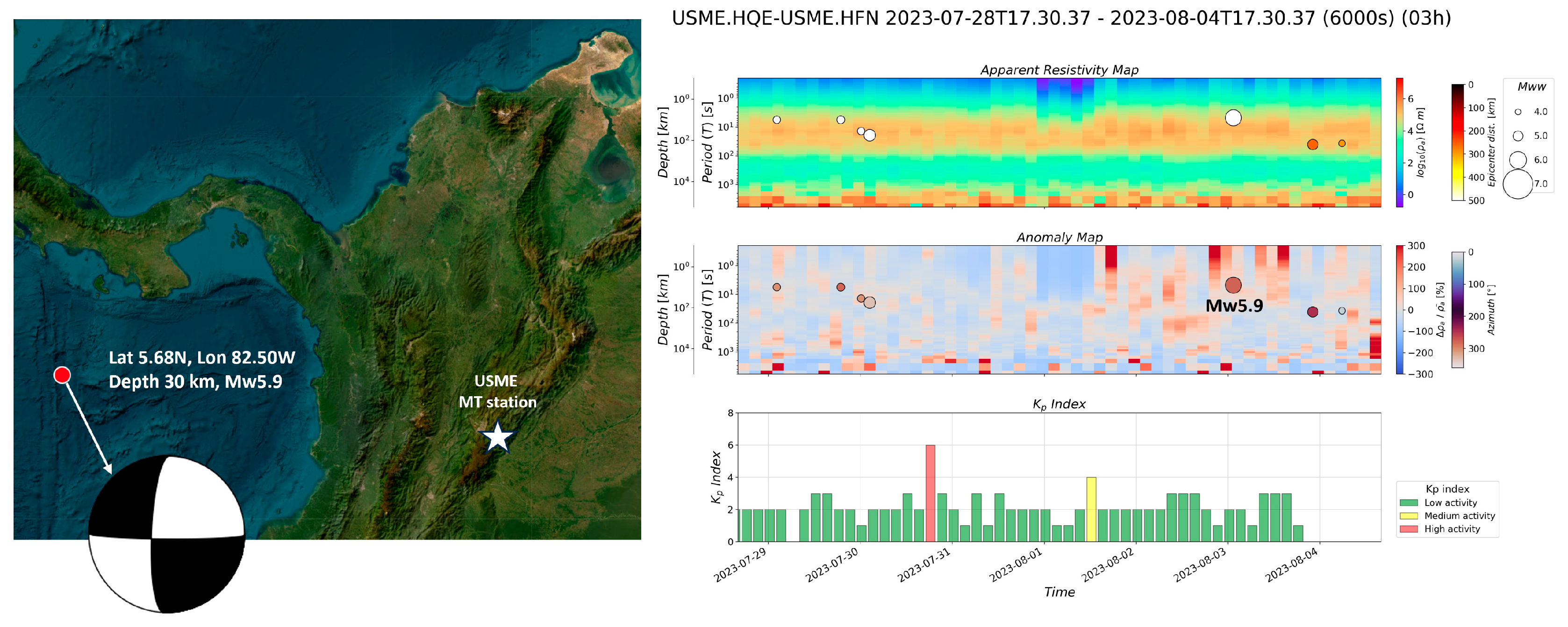
- Magnetotelluric deployments (MT): Time-frequency MT techniques can be integrated into permanent monitoring systems. Surficial or even at depths near earthquake or volcanic sources, changes in electrical resistivity may serve to identify transient or precursor signals [4,5,6]. Including MT data in a comprehensive monitoring system can improve the accuracy of early warnings. An appropriate example of this approach is being developed by the Geophysical Network of the National University of Colombia (RGUNAL), where complementing MT analysis with light gases suggests the migration of fluids and possible gradients in pore pressure in the phase before earthquakes and/or volcanic eruptions (Figure 1).
- Satellite-based Radar Interferometry (InSAR): InSAR measures ground deformation caused by seismic and volcanic activity. It involves comparing radar images of the same area at different times to detect even small ground movements. Improving the resolution could provide more detailed deformation during the evolution of a region’s seismic or volcanic cycle [10,11,12].
Funding
Acknowledgments
Conflicts of Interest
References
- Sun, Q.; Zhang, H.; Huang, S.; You, Z. Distributed Fiber Optic Sensing for Seismic Monitoring: A Comprehensive Review. Sensors 2020, 20, 3753. [Google Scholar]
- Lindsey, N.J.; Chalari, A.; Martin, E.R.; Lindsey, C.G. Distributed Acoustic Sensing (DAS) of Microseismicity at Brady Hot Springs, Nevada: Quantifying Fiber-Optic Cable Attributes for Seismic Monitoring. Geophysics 2019, 84, 1–23. [Google Scholar]
- Wada, T.; Ide, S.; Shiomi, K. Real-time monitoring of microseismicity using a dense array of fiber optic cables. Geophys. Res. Lett. 2018, 45, 2255–2262. [Google Scholar]
- Vargas, C.A.; Caneva, A.; Solano, J.M.; Gulisano, A.M.; Villalobos, J. Evidencing Fluid Migration of the Crust during the Seismic Swarm by Using 1D Magnetotelluric Monitoring. Appl. Sci. 2023, 13, 2683. [Google Scholar] [CrossRef]
- Vargas, C.A.; Gomez, J.S.; Gome, J.J.; Solano, J.M.; Caneva, A. Space–Time Variations of the Apparent Resistivity Associated with Seismic Activity by Using 1D-Magnetotelluric (MT) Data in the Central Part of Colombia (South America). Appl. Sci. 2023, 13, 1737. [Google Scholar] [CrossRef]
- Yohannes, L.D.; Heinson, G.; Thiel, S.; Krieger, L. Magnetotelluric monitoring of permeability enhancement at enhanced geothermal system project. Geothermics 2017, 66, 23–38. [Google Scholar] [CrossRef]
- Giovannetti, V.; Lloyd, S.; Maccone, L. Quantum-enhanced measurements: Beating the standard quantum limit. Science 2004, 306, 1330–1336. [Google Scholar] [CrossRef]
- Kasevich, M.A.; Chu, S. Measurement of the gravitational acceleration of an atom with a light-pulse atom interferometer. Appl. Phys. Lett. 1991, 69, 2259–2261. [Google Scholar] [CrossRef]
- Ménoret, V.; Vermeulen, P.; Le Moigne, N.; Bonvalot, S.; Bouyer, P.; Landragin, A.; Desruelle, B. Gravity measurements below 10−9g with a transportable absolute quantum gravimeter. Sci Rep 2018, 8, 12300. [Google Scholar] [CrossRef]
- Fielding, E.J.; Winberry, J.P. Synthetic Aperture Radar Interferometry. Annu. Rev. Earth Planet. Sci. 2020, 48, 419–447. [Google Scholar]
- Berardino, P.; Fornaro, G.; Lanari, R.; Sansosti, E. A new algorithm for surface deformation monitoring based on small baseline differential SAR interferograms. IEEE Trans. Geosci. Remote Sens. 2002, 40, 2375–2383. [Google Scholar] [CrossRef]
- Zebker, H.A.; Villasenor, J. Decorrelation in interferometric radar echoes. IEEE Trans. Geosci. Remote Sens. 1992, 30, 950–959. [Google Scholar] [CrossRef]
- Blewitt, G.; Kreemer, C. Harnessing the GPS Data Explosion for Interdisciplinary Science; Eos, Transactions American Geophysical Union: Washington, DC, USA, 2016; Volume 97. [Google Scholar]
- Bock, Y.; Melgar, D.; Crowell, B.W. Real-time strong-motion Broadband GPS: Network-based monitoring of co-seismic deformation. Seismol. Res. Lett. 2011, 82, 383–394. [Google Scholar]
- Fialko, Y.; Simons, M.; Agnew, D.C. The complete (3-D) surface displacement field in the epicentral area of the 1999 Mw 7.1 Hector Mine earthquake, California, from space geodetic observations. Geophys. Res. Lett. 2001, 28, 3063–3066. [Google Scholar] [CrossRef]
- Shiro, B.; Deitchman, R.S. Unmanned Aerial Systems for Volcano Observations; Eos, Transactions American Geophysical Union: Washington, DC, USA, 2019; Volume 100. [Google Scholar]
- Kerle, N.; Nex, F.; Gerke, M.; Vosselman, G. Guest Editorial: UAV-based remote sensing for applications in geology: Introduction to the Special Issue. Int. J. Appl. Earth Obs. Geoinf. 2017, 60, 1–4. [Google Scholar]
- Lin, G.; Raskin, G. The Contribution of UAVs to Earthquake Disaster Management; Eos, Transactions American Geophysical Union: Washington, DC, USA, 2018; Volume 99. [Google Scholar]
- Lindsey, E.O.; Lindsey, C.G. Low-Cost Seismometers: Advances and Opportunities. Seismol. Res. Lett. 2021, 92, 3255–3263. [Google Scholar]
- Haas, J.S.; Henrys, S.; Horleston, A.; Beavan, J. Citizen Seismology for Subduction Zone Monitoring: A Volunteer Network in New Zealand. Seismol. Res. Lett. 2019, 90, 367–378. [Google Scholar]
- Shrivastava, A.; Mohanty, W.K. Design and Evaluation of a Low-Cost MEMS Seismometer for Earthquake Monitoring Applications. IEEE Sens. J. 2021, 21, 5700–5707. [Google Scholar]
- Bensen, G.D.; Ritzwoller, M.H.; Barmin, M.P.; Levshin, A.L.; Lin, F.; Moschetti, M.P.; Shapiro, N.M.; Yang, Y. Processing seismic ambient noise data to obtain reliable broad-band surface wave dispersion measurements. Geophys. J. Int. 2007, 169, 1239–1260. [Google Scholar] [CrossRef]
- Lecointre, A.; Brenguier, F.; Shapiro, N.M.; Campillo, M. Surface wave array tomography in SE Tibet from ambient seismic noise and two-station analysis I. Phase velocity maps. Geophys. J. Int. 2012, 190, 173–187. [Google Scholar]
- Yudistira, T.; Nakano, M.; Kundu, B.; Yamanaka, H.; Kim, Y.S. On the noise-reducing performance of a helical-like seismic noise sensor. Sensors 2016, 16, 974. [Google Scholar]
- Yoon, C.E.; O’Reilly, O.J. Machine Learning in Earthquake Seismology: Recent Advances and Future Directions. Rev. Geophys. 2020, 58, e2019RG000672. [Google Scholar]
- Ross, Z.E.; Yue, Y.; Meier, M.A.; Hauksson, E.; Heaton, T.H. PhaseNet: A Deep-Neural-Network-Based Seismic Phase Picker for Local, Regional, and Teleseismic Data. Seismol. Res. Lett. 2018, 89, 2080–2090. [Google Scholar]
- Wang, D.; Chen, J.; Wang, W.; Wu, W.; Wu, F. A Deep Learning Approach for Seismic Signal Detection. Geophys. J. Int. 2019, 218, 1265–1280. [Google Scholar]
- Djamel, B.; Afonso, C.; Navas-Traver, I. A framework for immersive geospatial visualization using virtual reality devices. ISPRS J. Photogramm. Remote Sens. 2015, 105, 38–49. [Google Scholar]
- Hu, H.; Qian, Y.; Lu, Y.; Zhang, J. A novel framework for 3D visualization of geological structure based on virtual reality. Comput. Geosci. 2019, 124, 104–115. [Google Scholar]
- Liu, Z.; Luo, L.; Shi, X.; Wu, W. Virtual Reality-based Visualization and Exploration of Geospatial Data. ISPRS Int. J. Geo-Inf. 2019, 8, 411. [Google Scholar]
- Böse, M.; Dannemann, F.; Husen, S.; Tilmann, F. MyShake: A smartphone seismic network for earthquake early warning and beyond. Sci. Adv. 2015, 1, e1501055. [Google Scholar]
- Allen, R.M.; Cochran, E.S. Seismic Network Transforms Earthquake Detection; Eos, Transactions American Geophysical Union: Washington, DC, USA, 2011; Volume 92, pp. 277–278. [Google Scholar]
- Kong, Q.; Allen, R.M.; Schreier, L.; Kwon, Y.W. MyShake Early Warning Smartphone App. IASPEI Newsl. 2019, 57, 37–40. [Google Scholar]
- Newman, A.V.; Dixon, T.H.; Ofoegbu, G.; Dixon, J.E. Geodetic and seismic constraints on some seismogenic and non-seismogenic processes associated with the 2001 Bhuj earthquake. Bull. Seismol. Soc. Am. 2006, 96, 1910–1927. [Google Scholar]
- Uchida, N.; Matsubara, M.; Ellsworth, W.L. Rapid fault-type discrimination using real-time GPS and seismic data: The 2018 Palu, Sulawesi earthquake case study. Geophys. Res. Lett. 2019, 46, 1921–1928. [Google Scholar]
- Geng, J.; Ding, J.; Yin, X. A real-time dynamic GPS deformation monitoring system for landslides. Landslides 2018, 15, 1213–1225. [Google Scholar]
- Fan, K.; Ren, Y.; Li, H.; Yang, Y.; Yang, Z. Blockchain-based secure firmware update for Internet of Things devices. IEEE Trans. Ind. Inform. 2018, 15, 410–418. [Google Scholar]
- Zheng, Z.; Xie, S.; Dai, H.N.; Chen, X.; Wang, H. An overview of blockchain technology: Architecture, consensus, and future trends. In Proceedings of the 2017 IEEE International Congress on Big Data (BigData Congress), Honolulu, HI, USA, 25–30 June 2017; pp. 557–564. [Google Scholar]
- Kalra, A.; Goel, S. Bitcoin: A comprehensive survey. IEEE Trans. Emerg. Top. Comput. 2017, 6, 384–402. [Google Scholar]
- USGS Search Earthquake Catalog. Available online: https://earthquake.usgs.gov/earthquakes/search/ (accessed on 19 September 2023).
Disclaimer/Publisher’s Note: The statements, opinions and data contained in all publications are solely those of the individual author(s) and contributor(s) and not of MDPI and/or the editor(s). MDPI and/or the editor(s) disclaim responsibility for any injury to people or property resulting from any ideas, methods, instructions or products referred to in the content. |
© 2023 by the author. Licensee MDPI, Basel, Switzerland. This article is an open access article distributed under the terms and conditions of the Creative Commons Attribution (CC BY) license (https://creativecommons.org/licenses/by/4.0/).
Share and Cite
Vargas, C.A. Advanced Technology and Data Analysis of Monitoring Observations in Seismology. Appl. Sci. 2023, 13, 10561. https://doi.org/10.3390/app131910561
Vargas CA. Advanced Technology and Data Analysis of Monitoring Observations in Seismology. Applied Sciences. 2023; 13(19):10561. https://doi.org/10.3390/app131910561
Chicago/Turabian StyleVargas, Carlos Alberto. 2023. "Advanced Technology and Data Analysis of Monitoring Observations in Seismology" Applied Sciences 13, no. 19: 10561. https://doi.org/10.3390/app131910561
APA StyleVargas, C. A. (2023). Advanced Technology and Data Analysis of Monitoring Observations in Seismology. Applied Sciences, 13(19), 10561. https://doi.org/10.3390/app131910561