Article

Multi-Scale Toolbox: An Automated ArcGIS Tool for Evaluating Pupil–Teacher Ratios in U.S. Public School Districts

1
Department of Geography and Environmental Studies, Texas State University, San Marcos, TX 78666, USA
2
School of Resource and Environmental Science, Wuhan University, Wuhan 430070, China
3
Liberal Arts and Science Academy, Austin, TX 78721, USA
4
School of Public Administration, China University of Geosciences, Wuhan 430074, China
*
Author to whom correspondence should be addressed.
Appl. Sci. 2022, 12(22), 11449; https://doi.org/10.3390/app122211449
Submission received: 22 September 2022 / Revised: 7 November 2022 / Accepted: 8 November 2022 / Published: 11 November 2022

Abstract

:
Due to the teacher shortage in the U.S., an automatic toolbox with secondary development based on the ArcPy package was created to explore the spatial imbalance of the pupil–teacher ratio. It consists of four tools (or toolsets) for multi-scale spatial visualization, a sensitivity analysis with a heat map, the ordinary least squares regression with spatial autocorrelation, and the random forest tree regression. This study demonstrated the application of the toolset in the evaluation of educational resource spatial misallocation. Firstly, multi-scale analysis results showed that, the loss of teachers was mainly distributed in Oregon, Nevada, Arizona, and California from the state level, while it focused on such counties as Terrebonne Parish, Concordia Parish, and Bienville Parish in Louisiana in the county level. Secondly, it was found through heatmap sensitivity analysis that pupil–teacher ratios were highly related to low levels of student support services staff, free lunch programs, and low levels of local education agency (LEA) administrators. Then, the OLS tool was used to automatically calculate the spatial weighted matrix, the Moran I, R2, and AICC indices, AdjR2, F-Stat, F-Prob, and the Wald statistic, which showed whether the model was significant or not. This was followed by random forest tree regression modeling, which found that the LEA administrative support staff and the totally free lunch number highly impacted pupil–teacher ratios. Besides, the designed tool provided ribbons for the Common Core of Data (CCD) to link to other data sources.

1. Introduction

The imbalance of the pupil–teacher ratio at various scales directly impacts education quality. An imbalanced teacher-to-student ratio has been linked to the loss of teaching staff, poor student performance, and long-term issues in local education sustainability [1]. The imbalance of the pupil–teacher ratio is a leading contributor to the nationwide shortage of teachers that has monotonically increased and outpaced projections [2,3,4]. Furthermore, the imbalanced distribution of teachers in the U.S. triggered the supply of qualified teachers, which was too small to handle the sudden increase in demand, resulting in many school districts having to hire teachers with limited training and credentials. Over the five-year period from 2011 to 2016, the proportion of teachers who were not fully certified increased from 8.4% to 8.8%; the proportion of teachers who had not taken a traditional route into teaching increased from 14.3% to 17.1%; the proportion of teachers who had five years or less of experience increased from 20.3% to 22.4%; and the proportion of teachers who did not have an educational background in the subject they were teaching increased from 31.1% to 31.5% [5]. In high-poverty schools, the shares of teachers without these credentials were even higher: 9.9% were not fully certified, 18.9% took an alternative route into teaching, 24.6% had five years or less of experience, and 33.8% didn’t have an educational background in the subject they were teaching (NCES 2011–2012, 2015–2016) [6]. This shortage has an impact on the quality of teaching that occurs within these institutions, and dates back to before the pandemic started. The Economic Policy Institute published a report showing that, during the 2017–2018 school year, there was an estimated demand for 110,000 teachers from the education system that was not being met by the current supply [7]. This was especially the case within low-poverty areas in which education should be taking precedence. The shortage following the COVID-19 pandemic caused mass furloughing. The Learning Policy Institute details the US Department of Education’s findings that “48 states and Washington, DC, reported having shortages of special education teachers; 43 states and DC reported math teacher shortages; and 41 states and DC had shortages of science teachers” [8]. Therefore, improving access to public teachers in under-served areas is a significant avenue for enhancing the quality of public education. In this research, pupil–teacher ratios were assessed using different ranking values at individual county and state levels. This was relevant to the modifiable areal unit problem (MAUP), which means analytical results were sensitive to the definition and aggregation of geographic units [9]. To solve this issue, the pupil–teacher ratio needed be analyzed at varying levels of scale and aggregation [10]. This research aims to create an automated python-based query toolbox to calculate pupil–teacher ratios and produce distribution maps of these ratios at different scales. An effective Public School District Teacher-Student Match Tool (PTMT) could be automated to quantify the correlation between teachers and students using multi-scalar statistical analysis. This would provide a foundation for identifying areas of concern and further optimizing teacher–student resource allocation. The long-term goals are to mitigate public school teacher shortage pressure, optimize education resource management, and maximize teacher staffing allocation to meet student demand.
The research on pupil–teacher ratios was first mentioned by Lewit & Baker (1997) as they highlighted class size measure [11], defined as dividing the enrollment number of students by the number of full-time teachers in the same area. Previous research focused on reducing pupil–teacher ratios in classrooms to enhance the pedagogical quality [12,13,14,15,16,17]. Pupil–teacher ratios were also viewed as crucial factors for moderating the association between teacher burnout and bullying behavior [18,19]. Nevertheless, current studies of pupil–teacher ratios paid more attention to adding a teacher in the classroom, instead of taking students out. This fully changed strategies for controlling pupil–teacher ratios at the class level [20]. However, the question of how to compute socio-economic, political, and environmental impacts on pupil–teacher ratios is more essential. In this research, we constructed a platform to connect pupil–teacher ratios with other factors at the county and state levels in the U.S. Furthermore, we extended the “effect base” paradigm to delineate the complex education system change with pupil–teacher ratios in space and time. This is due to two existing education research of the “mechanism based” paradigm and the “effect base” paradigm that Maroulis et al. (2020) mentioned [21]. In addition, we utilized random forest tree modelling of machine learning to expose the association between pupil–teacher ratios and 23 educational factors, thanks to machine learning algorithms having high data processing speeds and accuracies [22,23,24,25].
Owing to the advantage of visualizing the distribution of ecological diversity across geographic space, the GIS toolbox was well documented in the research of natural resource utilization and protection [26,27,28,29,30,31], and even extended to molecular research. For instance, the genetic landscapes GIS toolbox could be used to explore associations between patterns of genetic diversity and geographic features [32]. Using the GIS toolbox to explore the association between the pupil–teacher ratios and factors of socio-economic and political growth is muti-disciplinary research. In Web of Science, there was little literature relevant to this topic, except for Dobesova Zdena (2012), who proposed visual programming that could convert graphic versions of models into Python script for novice programmers to avoid simple mistakes [33]. They mainly took into account the application of the Model Builder in Arc GIS software (v. 10.1), and did not mention Python scripts to produce the spatial distribution of pupil–teacher distributions. In addition, compared to the existing public school districts and public school search system in the National Center for Education Statistics (https://nces.ed.gov/ccd/districtsearch/, accessed on 7 November 2022), the toolbox we developed has the following strengths. First, it not only incorporates the current school year of the Common Core of Data (CCD), but also spans all school years of the CCD (1987–2021). Second, due to lack of spatial representation in the existing system, mapping out public school districts information on the PTMT was essential to identify the spatial discrepancy of educational quality and its potential contributing factors. Third, a semantic spatial-temporal public school district system was required for an integrated trajectory model of pupil–teacher ratios using spatial and temporal analysis. Finally, it models trend-lines with diverse machine learning algorithms, which showed patterns and variation in teacher supply and demand. It is worth noting that different decision makers take advantage of various model driven prediction systems for policymaking. These gaps will be filled by the PTMT.

2. Materials and Methods

2.1. Data

Data were acquired directly from the CCD (https://nces.ed.gov/programs/edge/Geographic/SchoolLocations, accessed on 7 November 2022) in tabular format. Spatial geometry files were downloaded from the US Census Bureau FTP matching the tabular data year. This research used district-level data from the 2015–2018 year as a sample set. The CCD is the Department of Education’s primary database on public elementary and secondary education in the United States. CCD produces an annual national database of all public elementary and secondary schools and school districts. The primary purpose of the CCD is to provide basic information on public elementary and secondary schools, local education agencies (LEAs), and state education agencies (SEAs) for each state, the District of Columbia, and outlying U.S. territories. CCD data is composed of two components: non-fiscal and fiscal. Non-fiscal CCD is the primary data used for this research, and includes information on teacher and student numbers. Table 1 exhibits the dependent variable of student–teacher ratio and 23 independent variables, including staff, school administrators, librarians, and registrants for the free lunch program.

2.2. Study Area

This study area refers to 55 states in the U.S., including 18,861 school districts and 99,265 public elementary and secondary schools. The statistics of teacher numbers were based on public elementary and secondary school level in Figure 1. The statistics of student numbers were based on school district level in Figure 2.

2.3. Study Framework

The research outline in Figure 3 explicates that CCD geographical data were joined into U.S. census data to produce spatial correlational and regression analysis (i.e., Ordinary Least Square, Geographical Weighted Regression) in terms of teacher-related factors, such as employment, household income, house vacancy, health insurance, and school administrators.

2.4. The Toolbox Design Procedure

We synthetized GIS spatial statistics, data processing, and machine learning language in the specific education case in the U.S. The toolbox was designed into four component modules using a mixed method.
  • Module 1—the Join and Summarize tool
It processes and organizes the raw CCD data, then joins it to TIGER/Line shapefile geometry at the state and county scales, and finally calculates a pupil–teacher ratio for each state or county. These feature class outputs can then be used as inputs for the OLS/GWR tool. The Python pseudocodes are as follows:
  • Define parameters and standardized variables
  • Table To Geodatabase (CCD table to local geodatabase)
  • Define fields for summing aggregated data
  • Statistics (State and County tables derived from district CCD data)
  • AddField (Student Teacher Ratio in State and County Tables)
  • Calculate Field (Student Teacher Ratio from Sum_Student and Sum_Teacher at State
  • and County Levels)
  • Feature Class To Feature Class (geometry shapefiles to geodatabase)
  • Add Fields (Adjust joining fields-define specific field types)
  • Join (CCD State and County Tables to geometry feature classes
  • Module 2—the spatial OLS tool
We generated the spatial weight matrix and measured spatial autocorrelation to predict the tendency of the pupil–teacher ratio. In regression analysis, OLS is a traditional method for estimating a linear regression between dependent variables and independent variables [34]. Simple OLS is the estimation of a linear relationship between two variables. Our version of the OLS tool adds the spatial weighted matrix and spatial autocorrelation into one process. By the interactive window, the user defines seven parameters involving input feature class, output feature class, unique ID, independent variables, a dependent variable, a model regression result table, and a description result table. The Python pseudocodes include:
  • Ordinary Least Squares_stats (Cleaned CCD data table)
  • Geographically Weighted Regression_stats (Cleaned CCD data table)
  • Spatial Weight Matrix (Cleaned CCD data table)
  • Autocorrelation Function (OLS Function out table)
  • Module 3—the sensitive analysis tool
We utilized the seaborn package to create a 2-dimensional representation of the various relationships of data at each scale. The input for this requires an additional step between the Join and Summarize tool and processing. All non-numeric variable fields must be removed before the table can be used as an input for the heat map tool. The Python pseudocodes are as follows:
  • Define parameters as text
  • Create pandas data frame as cursor
  • Define seaborn heatmap output visual characteristics
  • Define input as cursor
  • Save heatmap output
  • Module 4—the random forest modelling tool
We incorporated random forest classifier, decision tree classifier, the permutation importance package, and random forest regressor of scikit-learn machine learning in Python. Base on permutation feature importance in scikit-learn [35], the Python pseudocodes are as follows:
  • Define parameters as text
  • Run Random Forest Classifier
  • Run Decision Tree Classifier
  • Run train_test_split
  • Run permutation_importance
  • Run Random Forest Regressor
Take parameters as inputs in Figure 4.

3. Case Study

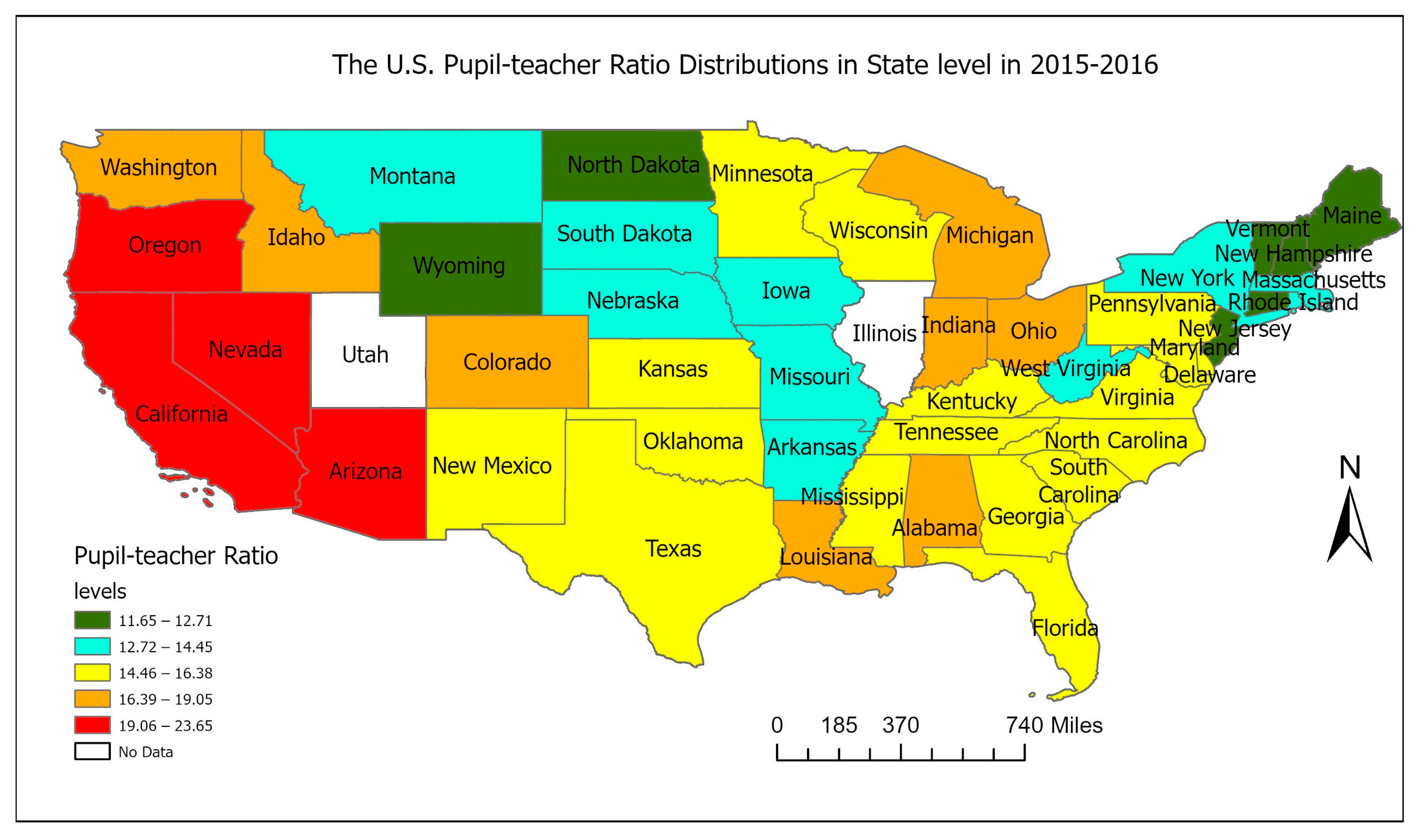
3.1. Multiscale Visualization

The pupil–teacher ratio is displayed at the state level in Figure 5. States in the U.S. were classified into five classes, with the dark red color states having the highest ratios and green states having the lowest ratios. In light of Figure 5, we could see that the high pupil–teacher ratios were located in Oregon, Nevada, Arizona, and California, while the low ones were distributed in North Dakota and Wyoming.
Interestingly, when we examined the same data at the county level, it was shown that the highest pupil–teacher ratios were narrowed down to a couple of counties, such as Terrebonne Parish, Concordia Parish and Bienville Parish counties in Louisiana, as seen in Figure 6. This indicated that the student–teacher ratio at the county level was more accurate than that at the state level.

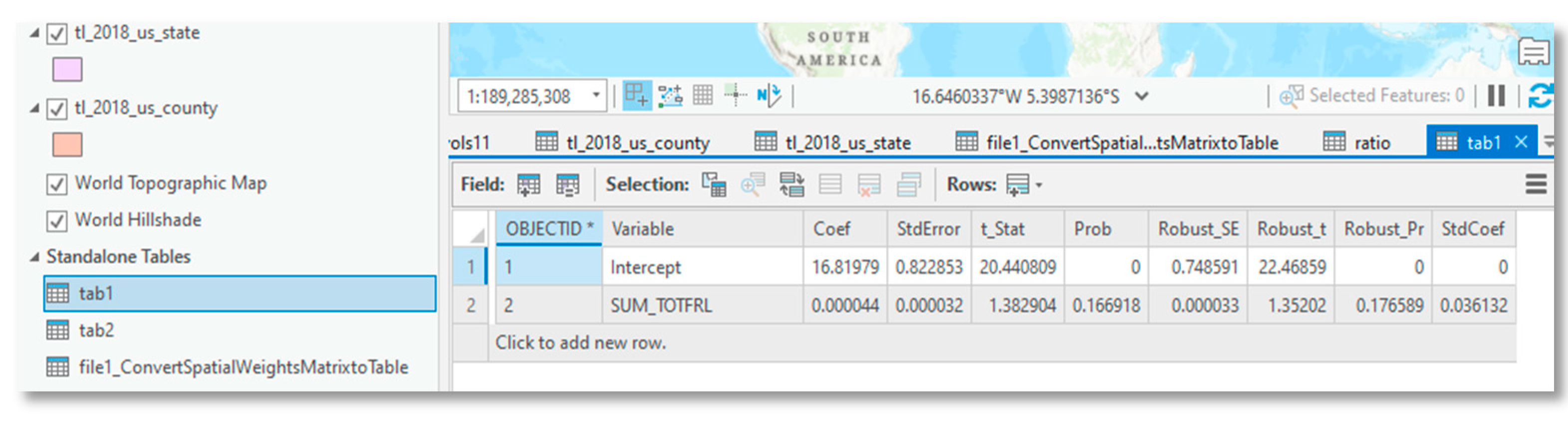
3.2. The OLS/GWR Tool Results

Based on the county map and state map generated in the multi-scale tool, we ran the OLS tool result to produce an output feature class, a model result parameter table, a model description table, and a spatial weight matrix table. The model result parameter table in Figure 7 contains intercept, independent variable coefficients, StdError, p-value, t-statistics, etc. The spatial weighted matrix is shown in Figure 8. The OLS tool did not effectively fit the sample dataset. Testing a variety of variables, we never reached a multiple r-squared higher than 0.6. This implies that there are wider influences on the pupil–teacher ratio than just those derivable from CCD data.

3.3. Heatmap Sensitivity Analysis Results

From the heatmap sensitivity analysis shown in Figure 9, we found that, out of the 23 variables tested, the pupil–teacher ratio was particularly highly correlated to student support services staff, free lunch program registrants, and the amount of local education agency (LEA) administrators.

3.4. Results of Modelling Random Forest Tree

As seen in Figure 10 of the random forest tree model, the variables of total free lunch number and LEA Administrative support staff had highly impacted the ratio.

4. Discussion

CCD geographical data provided the data source for spatial regression analysis with several strengths. First, the CCD data is a consistent national dataset, despite some states data being missing. Compared to the Schools and Staffing Survey (SASS), the CCD data allow geographers to freely explore or monitor the spatial-temporal and dynamic trajectory of the association between students and teachers. Second, the CCD data are based on school and school district data across states. Multiple-dimension pupil–teacher ratio spatial distributions are beneficial to reveal different angles of teacher shortages. Most importantly, the CCD dataset is easy and sufficient to be transferred to coding-languages without software limitations. SASS data and teacher follow-up surveys are limited to statistical software such as STATA. Finally, CCD data embraces census data so that it is possible to implement education deep analysis with socio-economic and environmental comprehensive assessments, eventually generating multiple-solutions.
ArcToolbox is an integrated and basic application developed by the Environmental Systems Research Institute (Esri). It not only provides a reference to the toolboxes to facilitate user interface in ArcGIS for accessing and organizing a collection of geoprocessing tools, models and scripts, but it also accommodates all the tools required to perform any advanced task in a particular domain [36]. It is a platform in which all the tools required to carry out advanced Geoprocessing tasks are organized in a logical way. Our developed tool was built on ArcToolbox in the context of the GIS environment. In addition to ArcToolbox strengths, it is an object-oriented approach, leading to increased portability and reusability of the tools for use [37]. Most importantly, the toolbox has characteristics of high flexibility and scalability that could be widely utilized in spatial data processing. It synthetized spatial statistic functions in one toolbox, referring to spatial visualization, machine learning of the heatmap and the random forest tree model, and spatial OLS modeling. The tool was executed, and the results were automatically displayed in ArcGIS pro. The script tools can be run in the ArcGIS interface by ordinary GIS users with the Spatial Analyst extension. In general, users can conduct the tool by accepting or modifying the default parameters to meet their demands. Since the source code and software logic is also accessible to them at the time of software distribution, they can create new script tools by modifying the code or adding parameters into the tools to support their studies [38].
Albeit our ArcToobox is accomplished, several limitations should be considered. First, the proposed toolset is only appliable in the context of the GIS environment, which means users are required to have open access to QGIS or a valid Spatial Analyst license of the ArcGIS pro (ArcMap) software that can run the ArcPy site package. Second, the tool is limited to Python-installed packages. In other words, users are required to install the seaborn and the sci-kit-learn of the Python package, and then clone them in the GIS environment before running the ArcToolbox. Third, Python skill is necessary. The CCD data have a long period statistic from 1986 to 2021. Each year of CCD data contains school districts and schools’ records in the U.S. If users don’t have Python experience, once spatial data processing is problematic, the ArcToolbox will be insignificant. At last, interface limitations inevitably exist. For instance, the format of the spatial weighted matrix is an SWM file that could not automatically be opened. It is better to use the function of converting the spatial weights matrix to the table in the Spatial Statistics toolbox. With the update of ArcGIS versions, those limitations will be gradually eliminated.

5. Conclusions

The Multi-Scale Visualization toolbox applies the idea of modularity and displays seamless integration non-spatial data into spatial data through OLS and random forest tree regressions. The tool testing was carried out in a way oriented to the use of the CCD, mainly on the interface, interaction, visualization, and regression flexibility, etc. It was tested to run stably and meet the expected design goals. Two underling contributions should be noticed. From perspective of instinct functions of the tool, it provided educational, auxiliary, and technical assistance for educational analysis, due to a data integration tools that enable education researchers to access, integrate, transform, process and move data spanning various endpoints and across any infrastructure to support their data integration use cases. It also allows potential supporters to achieve consistent access and delivery of data across a wide spectrum of data sources and data types to meet the data consumption requirements of education applications and end users [39,40,41]. On the other hand, from the perspective of the case study, it generated county and state levels to connect U.S. census data. It is a pioneer that employed geographical spatial analysis strengths to address why and how teacher shortages existed in the U.S. It will facilitate educational scholars to deepen the root of teacher shortages with pupil–teacher ratios [42,43]. Therefore, this ArcTool box will have a higher application value for educational comprehensive development, and will be further optimized from the perspective of improving compatibility in the next stage.

Author Contributions

Conceptualization and methodology, X.W.; investigation, resources, and data curation, Y.Z.; writing—original draft preparation, X.W.; writing, reviewing, and editing, J.Z. and Y.Z.; supervision and project administration, J.Z. and D.Z.; reviewing, writing, and editing. All authors have read and agreed to the published version of the manuscript.

Funding

This research received no external funding.

Institutional Review Board Statement

Not applicable.

Informed Consent Statement

Not applicable.

Data Availability Statement

Not applicable.

Acknowledgments

We appreciate Keenon J. Lindsey and Hilary A. Ansah for coding assistance, and Yihong Yuan for providing some essential guidelines. We also would like to extend sincere gratitude to Li Feng’s NSF project for supporting the data source.

Conflicts of Interest

We declare no conflict of interest for this research.

References

  1. Sutcher, L.; Darling-Hammond, L.; Carver-Thomas, D. Understanding teacher shortages: An analysis of teacher supply and demand in the United States. Educ. Policy Anal. Arch. 2019, 27, 35. [Google Scholar] [CrossRef] [Green Version]
  2. Carothers, D.; Aydin, H.; Houdyshell, M. Teacher shortages and cultural mismatch: District and university collaboration for recruiting. J. Soc. Stud. Educ. Res. 2019, 10, 39–63. [Google Scholar]
  3. García, E.; Weiss, E.; Economic Policy Institute. Examining the Factors That Play a Role in the Teacher Shortage Crisis: Key Findings from EPI’s “Perfect Storm in the Teacher Labor Market” Series; Economic Policy Institute: Palo Alto, CA, USA, 2020. [Google Scholar]
  4. Learning Policy Institute. The Role of Principals in Addressing Teacher Shortages. Research Brief; Learning Policy Institute: Palo Alto, CA, USA, 2017. [Google Scholar]
  5. Clark, M.A.; Isenberg, E.; Liu, A.Y.; Makowsky, L.; Zukiewicz, M. Impacts of the Teach for America Investing in Innovation Scale-Up. Revised Final Report; Mathematica Policy Research: Princeton, NJ, USA, 2017. [Google Scholar]
  6. Hof, J.; Bevers, M. Spatial Optimization for Managed Ecosystems; Columbia University Press: New York, NY, USA, 2000. [Google Scholar]
  7. Carver-Thomas, D. Teacher Shortages Take Center Stage; Learning Policy Institute: Palo Alto, CA, USA, 2022; Available online: https://learningpolicyinstitute.org/blog/teacher-shortages-take-center-stage (accessed on 7 November 2022).
  8. Garcia, E.; Weiss, E. The Teacher Shortage is Real, Large and Growing, and Worse than We Thought; Learning Policy Institute: Palo Alto, CA, USA, 2019; Available online: https://www.epi.org/publication/the-teacher-shortage-is-real-large-and-growing-and-worse-thanwe-thought-the-first-report-in-the-perfect-storm-in-the-teacher-labor-market-series/ (accessed on 7 November 2022).
  9. Clark, W.A.V.; Avery, K.L. The Effects of Data Aggregation in Statistical Analysis. Geogr. Anal. 1976, 8, 428–438. [Google Scholar] [CrossRef]
  10. Fotheringham, A.S.; Wong, D.W.S. The Modifiable Areal Unit Problem in Multivariate Statistical Analysis. Environ. Plan. A Econ. Space 1991, 23, 1025–1044. [Google Scholar] [CrossRef]
  11. Lewit, E.; Baker, L.S. Class size. Future Child. 1997, 7, 112–121. [Google Scholar] [CrossRef]
  12. Peers, C. Class Size and Pupil-Teacher Ratios: Where Education and Economics Collide; Information Age Publishing: Charlotte, NC, USA, 2016. [Google Scholar]
  13. Jensen, M.T. Pupil-teacher ratio, disciplinary problems, classroom emotional climate, and turnover intention: Evidence from a randomized control trial. Teach. Teach. Educ. 2021, 105, 103415. [Google Scholar] [CrossRef]
  14. Solheim, O.J.; Opheim, V. Beyond class size reduction: Towards more flexible ways of implementing a reduced pupil–teacher ratio. Int. J. Educ. Res. 2019, 96, 146–153. [Google Scholar] [CrossRef]
  15. Wang, M.-T.; Eccles, J.S. Retracted: Multilevel Predictors of Math Classroom Climate: A Comparison Study of Student and Teacher Perceptions. J. Res. Adolesc. 2016, 26, 617–634. [Google Scholar] [CrossRef] [Green Version]
  16. Waasdorp, T.E.; Pas, E.T.; O’Brennan, L.M.; Bradshaw, C.P. A Multilevel Perspective on the Climate of Bullying: Discrepancies among Students, School Staff, and Parents. J. Sch. Violence 2011, 10, 115–132. [Google Scholar] [CrossRef] [Green Version]
  17. Finn, J.D.; Fish, R.M.; Scott, L.A. Educational Sequelae of High School Misbehavior. J. Educ. Res. 2008, 101, 259–274. [Google Scholar] [CrossRef]
  18. Jensen, M.T. Are test-based policies in the schools associated with burnout and bullying? A study of direct and indirect associations with pupil-teacher ratio as a moderator. Teach. Teach. Educ. 2022, 113, 103670. [Google Scholar] [CrossRef]
  19. Borman, G.D.; Dowling, N.M. Teacher Attrition and Retention: A Meta-Analytic and Narrative Review of the Research. Rev. Educ. Res. 2008, 78, 367–409. [Google Scholar] [CrossRef]
  20. Jensen, M.T.; Solheim, O.J. Exploring associations between supervisory support, teacher burnout and classroom emotional climate: The moderating role of pupil teacher ratio. Educ. Psychol. 2019, 40, 367–388. [Google Scholar] [CrossRef] [Green Version]
  21. Maroulis, S.; Guimerà, R.; Petry, H.; Stringer, M.J.; Gomez, L.M.; Amaral, L.A.N.; Wilensky, U. Complex Systems View of Educational Policy Research. Science 2010, 330, 38–39. [Google Scholar] [CrossRef]
  22. Han, X.; Huwan, T. The Modular Design of an English Pronunciation Level Evaluation System Based on Machine Learning. Secur. Commun. Netw. 2022, 2022, 1–11. [Google Scholar] [CrossRef]
  23. Jung, A. Machine Learning: The Basics; Springer: Berlin/Heidelberg, Germany, 2022. [Google Scholar]
  24. Amin, M.N.; Iqbal, M.; Ashfaq, M.; Salami, B.A.; Khan, K.; Faraz, M.I.; Alabdullah, A.A.; Jalal, F.E. Prediction of Strength and CBR Characteristics of Chemically Stabilized Coal Gangue: ANN and Random Forest Tree Approach. Materials 2022, 15, 4330. [Google Scholar] [CrossRef]
  25. Jun, M.-J. A comparison of a gradient boosting decision tree, random forests, and artificial neural networks to model urban land use changes: The case of the Seoul metropolitan area. Int. J. Geogr. Inf. Sci. 2021, 35, 2149–2167. [Google Scholar] [CrossRef]
  26. Shah, M.; Lone, M.A. Flood Modeling and Simulation Using HEC-HMS/HEC-GeoHMS and GIS Tools for River Sindh-NW Himalayas. KN—J. Cartogr. Geogr. Inf. 2022, 1, 1–9. [Google Scholar] [CrossRef]
  27. Khatri, S.; Kokane, P.; Kumar, V.; Pawar, S. Prediction of waterlogged zones under heavy rainfall conditions using machine learning and GIS tools: A case study of Mumbai. GeoJournal 2022, 1, 1–15. [Google Scholar] [CrossRef]
  28. Shen, D.; Dong, S. Transition of Urban Morphology in the Mountainous Areas Since Early-Modern Times from the Perspective of Urban Historic Landscape—A GIS Tools and Historical Map Translation Approach. Sustainability 2022, 14, 12896. [Google Scholar] [CrossRef]
  29. Dawidowicz, A.; Dudzińska, M. The Potential of GIS Tools for Diagnosing the SFS of Multi-Family Housing towards Friendly Cities—A Case Study of the EU Member State of Poland. Sustainability 2022, 14, 6642. [Google Scholar] [CrossRef]
  30. Tamiru, H.; Wagari, M. Comparison of ANN model and GIS tools for delineation of groundwater potential zones, Fincha Catchment, Abay Basin, Ethiopia. Geocarto Int. 2021, 37, 6736–6754. [Google Scholar] [CrossRef]
  31. Fartas, N.; El Fellah, B.; Mastere, M.; Benzougagh, B.; El Brahimi, M. Potential Soil Erosion Modeled with RUSLE Approach and Geospatial Techniques (GIS Tools and Remote Sensing) in Oued Joumouaa Watershed (Western Prerif-Morocco). Iraqi Geol. J. 2022, 55, 47–61. [Google Scholar] [CrossRef]
  32. Vandergast, A.G.; Perry, W.M.; Lugo, R.V.; Hathaway, S.A. Genetic landscapes GIS Toolbox: Tools to map patterns of genetic divergence and diversity. Mol. Ecol. Resour. 2010, 11, 158–161. [Google Scholar] [CrossRef] [PubMed]
  33. Dobesova, Z. Visual Programming for Novice Programmers in Geoinformatics. Proc. Int. Multidiscip. Sci. GeoConference SGEM 2012, 3, 433–440. [Google Scholar] [CrossRef]
  34. Wu, X.; Zhang, J. Exploration of spatial-temporal varying impacts on COVID-19 cumulative case in Texas using geographically weighted regression (GWR). Environ. Sci. Pollut. Res. 2021, 28, 43732–43746. [Google Scholar] [CrossRef]
  35. Wu, X.; Denise, B.-B.; Zhan, F.; Zhang, J. Determining Association between Lung Cancer Mortality Worldwide and Risk Factors Using Fuzzy Inference Modeling and Random Forest Modeling. Int. J. Environ. Res. Public Health 2022, 19, 14161. [Google Scholar] [CrossRef]
  36. Brown, J.L.; Bennett, J.R.; French, C.M. SDMtoolbox 2.0: The next generation Python-based GIS toolkit for landscape genetic, biogeographic and species distribution model analyses. PeerJ 2017, 5, e4095. [Google Scholar] [CrossRef] [Green Version]
  37. Batelaan, O.; Zhong-Min, W.; De Smedt, F. An Adaptive GIS Toolbox for Hydrological Modelling; IAHS Publication: Washington, DC, USA, 1996; p. 235. [Google Scholar]
  38. Wanghe, K.; Guo, X.; Wang, M.; Zhuang, H.; Ahmad, S.; Khan, T.U.; Xiao, Y.; Luan, X.; Li, K. Gravity model toolbox: An automated and open-source ArcGIS tool to build and prioritize ecological corridors in urban landscapes. Glob. Ecol. Conserv. 2020, 22, e01012. [Google Scholar] [CrossRef]
  39. Marwedel, P. Embedded System Design: Embedded Systems Foundations of Cyber-Physical Systems, and the Internet of Things, 4th ed.; Springer: Berlin/Heidelberg, Germany, 2021. [Google Scholar]
  40. Deambi, S. Photovoltaic System Design: Procedures, Tools and Applications; CRC Press: Boca Raton, FL, USA, 2016. [Google Scholar]
  41. Dennis, A.; Wixom, B.H.; Roth, R.M. System Analysis and Design, 5th ed.; John Wiley: Hoboken, NJ, USA, 2012. [Google Scholar]
  42. How, A.I. Growth trends for selected occupations considered at risk from automation. Growth 2022, 2, 1–34. [Google Scholar]
  43. Zhang, P. Can public subsidy on education reduce wage inequality in the presence of automation? Ekon. Istraživanja 2022, 2, 1–17. [Google Scholar] [CrossRef]
Figure 1. Public school districts teacher distribution in the U.S.
Applsci 12 11449 g001
Figure 2. Public school districts student distribution in the U.S.
Applsci 12 11449 g002
Figure 3. Chart showing the general flow of data and tools in the toolbox.
Applsci 12 11449 g003
Figure 4. Set up parameters of the OLS tool.
Applsci 12 11449 g004
Figure 5. Student–teacher ratio displayed at state level.
Applsci 12 11449 g005
Figure 6. Student–teacher ratio displayed at county level.
Applsci 12 11449 g006
Figure 7. Model result parameter table example.
Applsci 12 11449 g007
Figure 8. The spatial weighted matrix.
Applsci 12 11449 g008
Figure 9. Result of the heatmap tool.
Applsci 12 11449 g009
Figure 10. Results of random forest tree regression.
Applsci 12 11449 g010
Table 1. List of variables from CCD tabular data.
CategoryNo.Variable NameVariable TypeVariable Description
Dependent variable1Student-teacher ratioNumthe number of students per teacher
Independent variables1SCHSUPNumSchool administrative support staff
2SECTCHNumTeachers-Secondary
3STAFFNumTotal staff FTE
4ELMGUINumGuidance counselors/directors-Elementary
5KGTCHNumTeachers-Kindergarten
6LEASUPNumLEA Administrative support staff
7PARANumInstructional aides/paraprofessionals
8SECGUINumGuidance counselors/directors-Secondary
9CORSUPNumInstructional coordinators and supervisors
10ELMTCHNumTeachers-Elementary
11LIBSUPNumLibrarians/media support staff
12SCHADMNumSchool administrators
13STUSUPNumStudent support services staff
14GUINumGuidance counselors/directors-Other
15LEAADMNumLocal education agency (LEA) administrators
16LIBSPENumLibrarians/media specialists
17OTHSUPNumAll other support services staff
18PKTCHNumTeachers-Prekindergarten
19UGTCHNumTeachers-Ungraded
20TOTGUINumGuidance counselors/directors-Total
21TOTFRLNumtotal eligible free lunch
22FRELCHNumCurrent free lunch
23REDLCHNumReduce free lunch
Publisher’s Note: MDPI stays neutral with regard to jurisdictional claims in published maps and institutional affiliations.

