Abstract
Ten detailed sections have been logged and studied from the “Infra-Cenomanian’’ to the Cenomanian–Turonian deposits in the Errachidia–Boudnib–Erfoud Basin between Tazzouguerte and Anounizme(SE Morocco). They show variations in their lithology and microfacies that reflect changes in the depositional environment from the base to the top of the sedimentary record. Indeed, depositional setting grades from a fluvial environment marked by sandstone deposits of the Ifezouane Formation to an alluvial plain and coastal lagoon environment comprising an alternation of red clay, gypsum, and green marl beds of the Aoufous Formation and, finally, towards shallow to moderately deep marine environments with the deposition of the carbonates of the Akrabou Formation. Correlations between the studied sections show variations in the thickness of strata throughout the basin. The variations recorded in the so-called “Infra-Cenomanian” series may be related to the structuration of the basement. The Cenomanian–Turonian carbonate platform shows deeper marine and thicker sediments towards the east, while it thins towards the west until its disappearance in Anounizme. This reflects the global Cenomanian–Turonian transgression in the Errachidia–Boudnib–Erfoud Basin from the eastern Tethyan realm towards the west. The regional correlation of the Errachidia–Boudnib–Erfoud Basin with the Ouarzazate and Agadir basins shows an eastward thinning of the Cenomanian–Turonian marine deposits of Agadir. This suggests the presence of a paleorelief at the Anounizme locality. This could be the boundary between the Errachidia–Boudnib–Erfoud Basin, with Tethyan influence, to the east and those of Ouarzazate and Agadir, with Atlantic affinity, to the west.
1. Introduction
The Cretaceous period in the Errachidia–Boudnib–Erfoud Basin (Figure 1) has been the subject of several studies previously initiated in the thirties of the twentieth century as introductory works [1,2,3,4]. These studies were followed by other works that focused on the sedimentology, paleontology, and geochemistry of this basin [5,6,7,8,9,10,11,12,13,14,15,16,17,18,19,20,21,22]. However, studies that focus on the lateral extent of the formations throughout the basin remain scarce and do not cover the entire basin.

Figure 1.
Geotectonic domains of Morocco and the location of the study area (a). Geological map showing the location of the studied sections (b) ([23], simplified).
The analysis of the main facies of the so-called “Infra-Cenomanian” series ([7,9,24]) and the Cenomanian–Turonian carbonate platform throughout the basin (Figure 1) provides important information on their depositional conditions as well as on their stratigraphic and sedimentological characteristics. These deposits, resting on Jurassic units or directly on the Paleozoic or Neoproterozoic basement [23,25,26,27,28,29,30], are organized into three different formations, namely, the Ifezouane Formation, the Aoufous Formation, and the Akrabou Formation [2]. Previous studies have proven an Albian–Cenomanian age for the Ifezouane Formation and a Cenomanian age for the Aoufous Formation [9,27,31], but their general continental and non-fossiliferous characters make their dating difficult in the absence of precise geochronological markers. However, the Akrabou Formation is dated as Cenomanian–Turonian based on biostratigraphic and isotopic δ13C data [6,7,8,11,13,15,18,24,32,33].
This study deals with the detailed lithostratigraphic and sedimentological characterization of the deposits of the Albian–Turonian interval of the Errachidia–Boudnib–Erfoud basin. Indeed, this study will allow a better understanding of the different parameters and processes governing the sedimentation of these deposits. The correlations of the different sections studied will allow us to better define the lateral and vertical geometries of the studied stratigraphic record; then, we can better characterize paleoenvironmental changes of this region that took place during the Cretaceous period, allowing comparisons with other neighboring basins (Ouarzazate and Agadir basins).
2. Geological Setting
The Errachidia–Boudnib–Erfoud Basin is a foreland basin that forms the eastern part of the Preafrican Trough [13]. It is limited by the South Atlas Fault (SAF) and the Jurassic deposits of the High Atlas to the north, the Precambrian and Paleozoic of the Anti-Atlas to the south, and the Cenozoic Hamada of Guir to the east.
The basin is an asymmetric synclinorium consisting of sandstone deposits with the gypsum intercalation of the “Infra-Cenomanian”, carbonate deposits of the Cenomanian-Turonian, and clayey sands with evaporites of the Senonian [7,9,23,27,29,34,35,36]. It extends from the west to the east for more than 300 km, from the Tinghir region to Bouanane. Its width is at its maximum along the Boudnib meridian (75 km) and decreases at eastern and western extremities (Figure 1). The Cretaceous deposits of the basin are unconformably overlying Proterozoic, Paleozoic, or Upper Jurassic basements [25,26,27,28,29,30,35,36,37].
3. Materials and Methods
This study is based on a bed-by-bed survey of field data that consisted of bed-by-bed surveying ten detailed lithological sections covering the entire succession of the Errachidia–Boudnib–Erfoud basin. These sections, arranged from east to west, are as follows: Tazzouguerte, Errachidia, Tadighouste, Goulmima, Taddart N’Oumira, Tinghir, Foum El Kouss, Imiter, Tazoughmite, and Anounizme (Figure 1). These sections were chosen according to their location in the basin, in a way that covers the majority of the basin (Table 1). The approach consisted mainly in describing the lithology, the fossil content, sedimentary structures, and the geometry of the beds. Petrographic analysis was also carried out on sections made from carbonate rocks for paleontological and sedimentological purposes. Limestone microfacies were described following the classification of [38].

Table 1.
Geographical coordinates of the sections.
The studied sections were correlated nearly along an E-W cross-section between the Tazzouguerte region in the east and the Anounizme region in the west (Figure 1). Only six main sections (Tazzouguerte, Errachidia, Goulmima, Foum El Kouss, Imiter, and Anounizme) will be presented and detailed in this paper. Tadighouste, Taddart N’Oumira, Tinghir, and Tazoughmite sections are used complementarily for correlation purposes at the basin scale for a better understanding of lateral and vertical facies changes. Other sections in the Ouarzazate and Agadir basins, logged by [17,39], are used to follow the lateral evolution of the deposits towards the west. The lithologic features and colors used in all logs are shown in Figure 2.
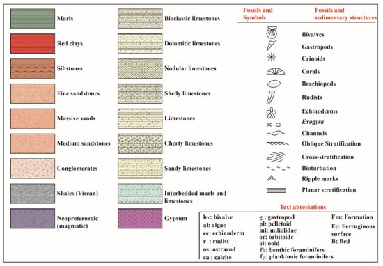
Figure 2.
Graphic legend for columnar sections presented in this work.
4. Lithostratigraphy
4.1. Tazzouguerte Section
The Tazzouguerte section is located to the east of Ksar Tazzouguerte. In this locality, the Cretaceous series (Figure 3a) lies on Jurassic deposits [25]. The lower part of this series is poorly visible because it is covered. This part of the series, which is more than a hundred meters thick, would correspond to fine-grained sandstones with oblique and planar stratifications of the Jbel Sidal and Ifezouane formations.

Figure 3.
Tazzouguerte section. (a) general view, along an east–west direction, showing the logged section; (b) variegated facies of the Aoufous Formation and the limestones of the Akrabou Formation; (c) fine limestone with bivalve shells; (d) limestone with rudists; (e) gastropod bioclastic limestone; (f) surface with bivalve shells; (g) limestone with silicified shell assemblages; (h) bedded limestone lying on a lumachelic level; (i) fine limestone with chert nodules.
The section begins with a thick variegated fine-grained unit (49 m; Figure 3b), which starts with green marls and red clays (0–8.5 m). From 8.5 to 15.5 m, beds are poorly visible due to talus scree. The top of this fine-grained resistant unit comprises clays and marls alternating with decimetric primary gypsum beds and yellowish sandstones or calcareous sandstones (15.5–49 m). This part of the section corresponds to the Aoufous Formation [2] and is attributed to the Cenomanian [9,14,17,27,32]. At 49 m, a facies change is marked by the presence of a limestone succession with a total thickness of 198 m. It can be divided into four carbonate and resistant units separated by three softer and erodible less-resistant units (Figure 3a).
The first resistant unit (49–73 m) begins with dolomitic limestones and is followed by a bivalve bioclastic limestone level (64–66.5 m); bioclastic wackestones showing the shells a foliated internal structure (Figure 4a); and limestones (wackestone–packstone) with lamellibranch, echinoid, and ostracod bioclasts (Figure 4b). The top of the resistant unit consists of bioturbated dolomitic limestones. This first resistant unit is surmounted by an interval (73–84 m) consisting of thin-bedded and fine-grained limestones with bivalve shells (Figure 3c).
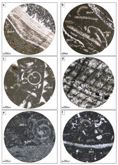
Figure 4.
Thin section photographs of limestone microfacies of the Akrabou Formation in the Tazzouguerte section. (a) wackestone microfacies with bivalves (bv); (b) bioclastic wackestone to packstone with bivalves (bv); (c) bioclastic wackestone with gastropod (g) and bivalves; (d) details of a rudist shell (r); (e) bioclastic wackestone to packstone with benthic foraminifera (bf); (f) packstone microfacies with bivalves (bv) and algae (al).
The second resistant unit (84–104 m), begins with bioclastic limestones with diverse fossiliferous content, mainly corals, echinoids, and crinoids. It grades to coral limestones, followed by limestones. The resistant unit ends with limestones containing gastropods and echinoids overlaid by a thick interval (104–147 m), which begins with fine-grained limestones with bivalve and gastropod shells. Its middle part is composed of bioclastic limestone that is very rich in rudists, gastropods, and bivalves (Figure 3d). The microfacies correspond mainly to wackestone to packstone with a wide diversity of organisms (Figure 4d). The interval ends with limestones rich in thick gastropods.
The third resistant unit (147–162 m) is composed of a loaf-shaped limestone containing small bivalve shells alternating with lumachellic levels composed of thick bivalves (Figure 3f). This resistant unit is followed by a new interval (162–210 m) that begins with fine-grained limestone with stratiform and nodular chert overlying a bedded limestone with shell-rich levels (Figure 3g). This is a wackestone-to-packstone limestone with bivalve and gastropod bioclasts (Figure 4c). Above, a massive whitish limestone is deposited, followed by loaf-shaped limestones. The top of the interval ends with whitish laminated limestone.
From 210 m, the fourth and last resistant unit can be seen; it starts with a loaf-shaped limestone containing a bivalve shell assemblage. This limestone also contains benthic foraminifera (Figure 4e). This is followed by fine-grained limestone that is overlain by bedded limestone that is intercalated by lumachellic levels (Figure 3h). The bed continues with bioturbated fine-grained limestone on which rests bedded limestones with stratiform and nodular form cherts (Figure 3i). The tops of the deposits show very shelled pavements. Above, a fine loaf-shaped limestone is deposited. The top of the resistant unit ends with bioclastic and bioturbated limestone levels. The microfacies are packstone limestone with bivalves and brachiopods (Figure 4f). This upper part of the section (calcareous beds) corresponds to the Akrabou Formation [2], dated as Cenomanian–Turonian [9,13,15,17,18,32].
4.2. Errachidia Section
This section is located northwest of Errachidia city. The survey started from a river bed (Figure 5a), where red clays with green marls beds crop out (Figure 5b). These variegated facies are followed by a succession of three thick sandstone bed sets with a total thickness of 60 m, formed essentially by fine-grained sandstones with oblique (Figure 5c) or, sometimes, planar bedding. The upper bedset finishes with a well-marked ferruginous surface. The clayey-marly facies and the overlying first two sandstones resistant units belong to the Jbel Sidal Formation [40], attributed to the Barremian–Aptian age [41,42,43], while the third sandstone resistant unit belongs to the Ifezouane Formation [2], attributed to the Albian age [9,27].

Figure 5.
Errachidia section. (a) east–west landscape showing the Cretaceous series of Errachidia; (b) view of the thick reddish sandstone bed resting on variegated facies; (c) cross-sectional view of an oblique stratification in a reddish sandstone bed; (d) greenish marly facies; (e) cross-section of a clayey facies intersected by secondary gypsum slits (Neptunian dykes); (f) close-up view of a primary gypsum bed; (g) general view showing a succession of limestone resistant units separated by intervals of terrigenous sediments; (h) dolomitic limestone presenting small geodes with a blackish ferruginous crust; (i) small geodes which show a calcareous filling with bivalve shells.
The middle part of the section (73–247 m) is formed by a succession of red clays containing gypsum veins (Figure 5e), green marl, and centimetric to metric beds of laminated primary gypsum (Figure 5d,f). Towards the top, marls and gypsum are dominant compared to red clays, and centimetric beds of laminated limestone appear. This part of the series corresponds to the Aoufous Formation [2], attributed to the Albian–Cenomanian age [9,17,27].
The section ends with a thick carbonate resistant unit of 122 m in total (Figure 5g) organized in a succession of several facies that can be grouped, according to the topography, into three thick resistant units interspersed by more or less eroded intervals.
The first resistant unit (247–267.5 m) has, at its base laminated limestone, a brecciated top surface and then limestone with dispersed bivalve shells. The microfacies is wackestone with bivalves and brachiopods (Figure 6a). This is followed by a more or less soft limestone with bivalve shells and a brecciated appearance. Above, a fine-grained limestone with dispersed shells is deposited, which corresponds to a wackestone with lamellibranchs and echinoderms (Figure 6b). This is surmounted by a bioclastic limestone (wackestone) that is very rich in small bivalves, brachiopod, and gastropod shells (9 m; Figure 6c). The bed ends with limestone containing thick bivalve shells. This first bed is followed by an interval (267.5–298 m) formed at its base by marlstone, followed by a bioclastic limestone (wackestone) with bivalve and gastropod fragments (Figure 6d). Bedded facies organized in small beds of loaf-shaped limestone rest on this. The interval ends with bioclastic limestone rich in organic matter with bivalve and gastropod shells (Figure 6e). The microfacies correspond to a wackestone with bivalves, brachiopods, and algal fragments.
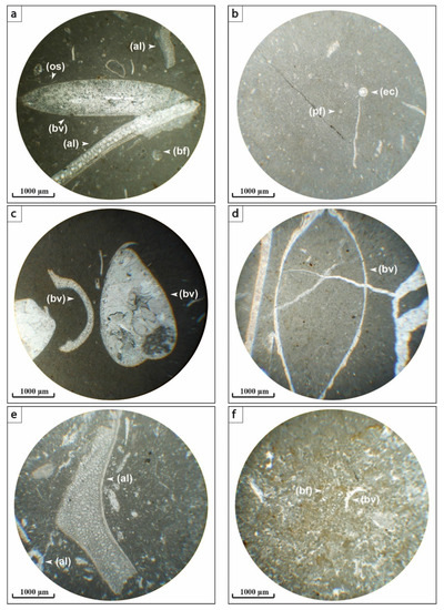
Figure 6.
Thin section photographs of limestone microfacies of the Akrabou Formation in the Er-rachidia section. (a) bioclastic wackestone containing bivalves (bv), algae (al), ostracods (os), and benthic foraminifera (bf); (b) mudstone with echinoids (ec); (c) wackestone containing recrystallized bivalve shells (bv); (d) wackestone with bivalve shells (bv); (e) wackestone containing broken algal fragments (phylloid algae); (f) peloidal wackestone containing bivalve shells (bv) and benthic foraminifera (bf, milioilidae).
At 298 m, a second carbonate-resistant unit begins consisting, from the bottom to the top, of limestone with thick bivalve shells and then limestone rich in shells and organic matter, which is itself followed by lumachellic facies with thick bivalve shells. This bed ends with bioclastic limestone with bivalves and gastropod shells. Above, there is an interval that begins with a lumachellic level very rich in small bivalves and gastropods capped by finely laminated limestone with bivalves and gastropod shells of different sizes. The first six meters of this laminated limestone contain nodular levels (Figure 5h). The interval ends with dolomitic limestone containing small geodes and bivalves (Figure 5i).
The third resistant unit (326–350 m) is composed of a succession of limestone beds. It begins with a lumachellic limestone that is rich in bivalve shells and crinoid stems and then a dolomitic limestone presenting blackish geodes, which contain bivalve shells. This facies ends with a small blackish lumachellic limestone level. Above, bluish bioclastic limestones are present with different-sized bivalve shells, topped by a lumachellic limestone. The rest of the resistant unit consists of alternating decimetric to metric levels of bioclastic limestone containing small bivalve shells separated by laminated and nodular limestone. The last bed that ends the resistant unit shows a level assemblage of silicified bivalves and gastropod shells at its top.
Above this third resistant unit lies a succession of facies with a total thickness of about 18.5 m, consisting of bioclastic limestone beds that are sometimes laminated and presenting a wackestone texture with milioilidae and bivalve bioclasts (Figure 6f), intercalated by yellowish to whitish altered limestone or nodular limestone. The entire carbonate escarpment that caps the entire series corresponds to the Akrabou Formation [2], dated as of the Cenomanian–Turonian age [9,13,15,17,18,32].
4.3. Goulmima Section
This section, which is 155m thick (Figure 7a), begins with a succession of multi-metric beds consisting of fine to medium-grained sandstones with some clayey and silty red intervals (up to 0–30.5m thick). These sandstones show oblique or, sometimes, planar laminations and ferruginous surfaces (Figure 7b). The lower part of the section corresponds to the Ifezouane Formation [2], attributed to the Albian [9,27].
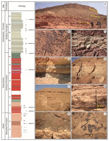
Figure 7.
Goulmima section. (a) general view of the series; (b) a ferruginous surface on the top of a sandstone bed of the Ifezouane Formation; (c) alternating red clays and green marls with centimetric limestone beds; (d) alternation of sandstone and limestone levels with a blackish clayey drape; (e) a metric bed of primary gypsum; (f) panoramic picture of the Cenomanian–Turonian unit; (g) lumachellic limestones with silicified shells; (h) nodular limestone level; (i) surface with concentrations of silicified shells.
From 30.5 m to 105 m, the section is composed of red clays and silts, green marls, a few sandstone beds, metric beds of primary gypsum, and sometimes centimetric carbonate levels (Figure 7c–e). This part of the section constitutes the Aoufous Formation [2] attributed to the Cenomanian [9,14,17,27,32].
The Goulmima section is capped by a thick limestone unit that lies on the last marly bed of the Aoufous Formation (105–155 m). This carbonate unit is divided into two thick hard and resistant members (B1 and B2), with another two weaker and less resistant to erosion intervals at their tops (Figure 7f).
The first resistant unit (105–123 m) begins with lumachellic limestone with small bivalve shells followed by limestone organized in centimetric beds. Above it lies a lumachellic limestone with coarser bivalve shells that is surmounted by a bedded limestone. Above this lies a lumachellic limestone rich in shells (Figure 7g), and its microfacies are packstone with lamellibranchs and brachiopods (Figure 8a). It is surmounted by a bedded limestone. The resistant unit ends with lumachellic facies with bivalve shells. Above it, there is an interval (123–135.5 m), which begins with laminated limestone organized in small beds and ends with nodular limestone (Figure 7h).
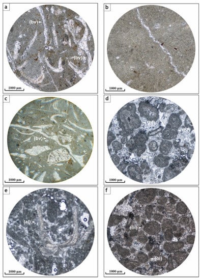
Figure 8.
Thin section photographs of limestone microfacies of the Akrabou Formation in the Goulmima section. (a) packstone with bivalves (bv); (b) mudstone; (c) wackestone to packstone with bivalve fragments; (d) packstone with benthic foraminifera; (e) packstone microfacies with algae; (f) oolitic packstone.
The second resistant unit (135.5–145 m) starts with limestone rich in silicified bivalve shells, followed by limestone with a karstified appearance. It is overlain by a succession of very bioclastic limestone beds, for which its microfacies are a wackestone to packstone with brachiopod bioclasts and algal fragments (Figure 8c). The resistant unit ends with a marl–limestone bed that rests on lumachellic facies that have a karstified appearance at their top.
Above, a succession of carbonate facies is deposited (145–155 m), which begins with laminated limestone, followed by karstified facies containing some upper bedding planes rich in silicified small shells (Figure 7i). Under the microscope, it is a packstone with benthic foraminifera (Figure 8d). This is overlain by a relatively less lithified limestone. The series continues with a succession of different facies, represented by a reddish-colored limestone followed by a limestone bed (Figure 8e) with small chert nodules. This bed is surmounted by laminated limestone on which again lies a reddish limestone. The succession continues with another softer limestone that is followed by a massive bioclastic limestone. Under the microscope, this is an oolitic packstone (Figure 8f). The interval ends with a marl–limestone bed on which lies a laminated limestone. The thick carbonate unit (105–155 m) corresponds to the Akrabou Formation [2], dated as of the Cenomanian–Turonian [9,13,15,17,18,32].
4.4. Foum El Kouss Section
The Foum El Kouss section is located approximately 17 km southwest of Tinghir city (Figure 9a) on either side of the RN10 national road leading to Ouarzazate. The studied section with a total thickness of 197 m discordantly lies on Paleozoic schists [44] (Figure 9b). The section begins with a micro-conglomerate metric bed containing reworked basement clasts. The lower part of the series (0–37 m) is formed by red sandstones that are organized into metric to multi-metric beds separated by silty-sandstone intervals. Beds contain coarser material at the base and are fining upward, and they show cross-stratification (Figure 9c). It sometimes ends with surfaces with ripple marks and burrows. This part of the series corresponds to the Ifezouane Formation [2] attributed to the Albian [9,27].
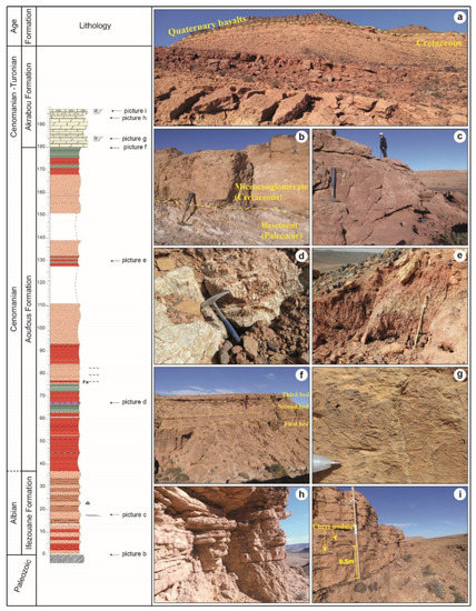
Figure 9.
Foum El Kouss section. (a) panoramic view showing Cretaceous deposits; (b) angular unconformity between the underlying Paleozoic basement and Cretaceous red sandstone; (c) red sand-stone bed showing cross-stratification; (d) primary gypsum bed; (e) red clays with some green marls; (f) overall view showing the succession of beds and intervals forming the Cenomanian–Turonian carbonate unit; (g) the top surface of a dolomitic bed strewn with bivalve shells; (h) interval organized in small limestone layers; (i) cross-section view showing nodular and stratiform cherts.
The middle part of the succession (37–180 m) begins with red clays, containing some centimetric sandstone and sandy limestone beds with, sometimes, bioturbated surfaces and some green marl levels. These clays are followed by an alternation of red clays, green marls, centimetric to metric primary gypsum beds (Figure 9d), and small sandstone beds that sometimes have ferruginous surfaces. From 76 m, dominance is restored for fine to medium-grained sandstone deposits, which alternate with red clays. A metric level of red clays is set up and topped by a 7.5 m-thick sandstone set. This latter is surmounted by an interval made up of red clays with intercalations of yellowish sandstones. Above, there is a second set for which its lower part is formed by sands and the upper part comprises sandstones with oblique stratifications. Approximately 16.5 m of the section (111–127.5 m) is not visible due to the screen cover. Above it lies an interval formed by red claystone with some green marl levels (Figure 9e) followed by fine-grained pink sand overlain by a metric fine-grained sandstone bed. A second observation gap is recorded from 139 m to 151 m, which probably corresponds to sandstone. Sandstones reappear again at 151 m, which starts with a bed of reddish to pinkish sandstone containing burrows, followed by a sandy interval. The succession ends with a thick pink sandstone bed with oblique lamination. It is overlaid by a 12 m-thick interval consisting of a succession of green marls and red clays with an increase in the dominance of the green facies towards its top. This middle part of the series extending from 37 m to 180 m corresponds to the Aoufous Formation [2], attributed to the Cenomanian [9,14,17,27].
At 180 m, a 17 m-thick carbonate unit is deposited on the last marly deposits of the Aoufous Formation. This platform is composed of three resistant units separated by intervals (Figure 9f). It begins with a resistant unit formed by a massive dolomitic limestone followed by a dolomitic limestone containing small geodes. It is classified as a mudstone-textured limestone with some bivalve bioclasts (Figure 10a). This resistant unit ends with a very bioclastic bed rich in bivalve and gastropod shells (Figure 9g). The microfacies correspond to a packstone with shell bioclasts and peloids (Figure 10b). Above, a bedded dolomitic limestone is deposited and organized in centimetric beds (15 to 25 cm), which form an interval between the first and second resistant units. It is classified as a mudstone with fine micrite and some small areas of recrystallization (Figure 10c).
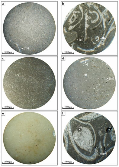
Figure 10.
Thin section photographs of microfacies of the Akrabou Formation in the Foum El Kouss section. (a) mudstone with rare bivalve shell bioclasts (bv); (b) packstone containing bivalve shells (bv) and peloids (pl); (c) mudstone with fine micrite and some small patches of recrystallization; (d) mudstone shows bioclasts of bivalve shells (bv); (e) mudstone with very fine micrite; (f) micrite (wackestone/packstone) with bivalve shells (bv).
The second resistant unit (188–193 m) consists essentially of a dolomitic limestone with a karstified appearance. Its microfacies correspond to a mudstone with some bioclasts (Figure 10d). A dolomitic limestone organized in centimetric beds forms a second interval (Figure 9h). Its microfacies are mudstone (Figure 10e). The carbonate platform ends with the last resistant unit (194.5–197 m), which is formed by bedded limestone containing chert as small nodules or as an assemblage of silicified bivalve and gastropod shells (Figure 9i). Its microfacies correspond to a packstone with shell bioclasts (Figure 10f). The thick platform, forming the upper part of the section, corresponds to the Akrabou Formation [2], dated as of the Cenomanian–Turonian [9,13,14,28,29].
4.5. Imiter Section
This section is located in the village of Imiter, along the RN10 national road. The studied section (Figure 11a) has a total thickness of 37 m. It begins with reddish siliciclastic deposits (0–24.5 m) consisting of a succession of sandstone beds (Figure 11b) and siltstone intervals. Sandstones show oblique and planar laminations (Figure 11d) and sometimes ripple marks. Above, an interval (24.5–34.5 m) appears, which begins with red clays and then variegated facies (red clays with green marl levels) and ends with green marls. This part of the section corresponds to the upper portion of the Aoufous Formation [2] and is attributed to the Cenomanian [27,28]. The series ends with a metric bed that begins with a massive yellowish limestone showing karstification forms at its top (Figure 11e). This is followed by a small interval of whitish bedded limestone and then by a brecciated limestone. The latter is surmounted by Senonian detrital deposits. This carbonate bed corresponds to the Cenomanian–Turonian Akrabou Formation [2,7,8,9,13,14,17,18,28,32].
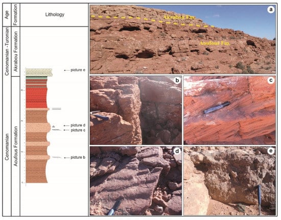
Figure 11.
Imiter section. (a) general view of the series; (b), metric sandstone bed with oblique lamination; (c) cross-sectional view showing a sandstone with oblique lamination framed by horizontal bedding; (d) the top surface of sandstone with wave ripples; (e) a cross-section of the carbonate unit, note the significant reduction in thickness when compared to previous sections.
4.6. Anounizme Section
The Anounizme section is located west of the Anounizme village. In this place, the Cretaceous series outcrops as a hill that discordantly overlies the Neoproterozoic basement (Figure 12) [26,28,45]. It is a red series consisting of sandstone beds alternating with sandy siltstones (Figure 12b,c). These beds, with a blackish patina, show oblique laminations (Figure 12d) and sometimes conglomeratic channel lags at their bases (Figure 12e). This series, which forms the first Cretaceous deposits in this area, corresponds to the Ifezouane Formation attributed to the Albian age [2,9,27,46,47,48,49].
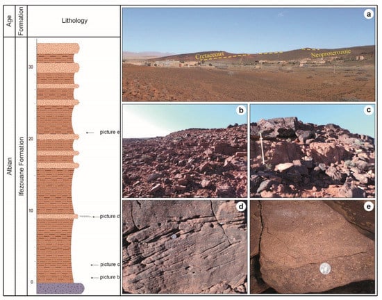
Figure 12.
Anounizme section. (a) geological unconformity between the Neoproterozoic basement and the Cretaceous series; (b,c) sandstone beds interspersed with sandy siltstone intervals; (d) sand-stone bed with oblique stratification; (e) sandstone with some channelized microconglomerate including Neoproterozoic elements.
5. Discussion
5.1. Paleoenvironments
Variations in the geometry of the deposits throughout the Cretaceous series of the Errachidia–Boudnib–Erfoud basin reflect changes in the depositional environment. Indeed, the base of the series (Ifezouane Formation) shows sandstones with oblique and cross-stratifications or silty sandstones with, sometimes, heterogeneous conglomerates. The facies characters of this formation suggest the presence of a fluvial depositional system [9,36,41,50,51,52].
The middle part of the series (Aoufous Formation) is characterized by a facies variation and, thus, by a variation in its depositional environment. It is represented by a succession of red clays, green marls, some sandstone beds, and primary gypsum beds. The facies changes reflect a depositional environment that varies between an alluvial plain sometimes crossed by fluvial systems and a coastal hypersaline lagoon [9,41,50,51,53].
The upper part of the series, which corresponds to the Akrabou Formation and is characterized by its exclusively carbonate facies, shows a radical change of the depositional environment towards an open-marine environment and lagoon bordered by rudist patch-reefs. This change in environments in the Preafrican Trough is associated with the transgression of the Cenomanian–Turonian [7,9,13,14,18,28,32,34,53,54,55,56,57]. The latter shows variations between an internal platform and a reef barrier, but the general character remains shallow to medium deep.
Based on the data acquired and described above, we attempted to make a paleoenvironmental reconstruction of the study area by using a synthetic block diagram that illustrates the period of the deposition of the Akrabou Formation (Figure 13).
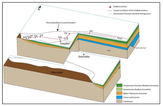
Figure 13.
Synthetic block diagram showing the arrangement of the Cretaceous formations in the Errachidia–Boudnib–Erfoud Basin, the studied sections are represented.
The Cretaceous sedimentation in the Errachidia–Boudnib–Erfoud Basin is governed, on one part, by paleoreliefs and, on the other, by the presence of normal faults (e.g., South Atlas Fault) with a northward tilting of blocks in the northern zone that increased the space available for deposition. To the east, the basin is deeper and shows shallow depths towards the paleoreliefs located to the south and west.
5.2. Stratigraphic Correlations within the Errachidia–Boudnib–Erfoud Basin
The studied sections in the Errachidia–Boudnib–Erfoud Basin have been correlated over more than 200 km along the Anounizme–Tazzouguerte transverse (Figure 14). These overall correlations carried out over the interval covering the Cenomanian–Turonian marine limestones (Akrabou Formation) and the underlying siliciclastic deposits, i.e., the Ifezouane and Aoufous formations, make it possible to follow the lateral variations of different facies.
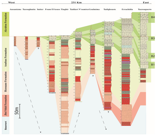
Figure 14.
Diagram showing the lithostratigraphic correlation of the studied sections along a west-east transect in the Errachidia–Boudnib–Erfoud Basin.
The absence of precise biostratigraphic markers within the red series called “Infra-Cenomanian” requires the use of lithostratigraphic markers. Indeed, the laterally continuous Cenomanian–Turonian unit constitutes a cartographic landmark on the entire Preafrican Trough. The base of the bedded white limestone containing chert is considered, here, as the boundary between the Cenomanian and the Turonian, as already suggested by [9,13,14].
This boundary serves as a datum level for all sections. The red series of the “Infra-Cenomanian” (Ifezouane and Aoufous formations) can easily be identified in the field as they are overlain by the Cenomanian–Turonian limestone. Red series rest, depending on the places, in concordance with Jurassic formations or even in discordance on the Pan-African or Hercynian basement. This series can be subdivided into two resistant units: a first one consisting mostly of sandstone (Ifezouane Formation); a second mixed unit with intercalations of clays, red sandstones, green marls, and gypsum (Aoufous Formation).
In the two sections of Anounizme and Tazoughmite (west of the transverse), the Ifezouane Formation is about 33.5 m-thick and is represented by essentially reddish sandstone deposits showing oblique laminations with some conglomeratic channels unconformably deposited on a Neoproterozoic basement. At the Foum El Kouss section, this formation of about 37 m is formed by metric to multi-metric beds of red sandstone separated by silty sandstone intervals. It lies in angular discordance on Paleozoic schists. At the Tinghir location, this formation thickens to reach more than 140 m. The Ifezouane Formation, here, is well-developed and is represented by a red sandstone series with clayey-siltstone intercalations, which are unconformably deposited over a basement of upper Visean age [44]. The formation decreases in thickness again towards the Taddart N’Oumira location (66 m), where it is composed of sandstone facies and some red clayey levels. It lies discordantly on the Paleozoic strata. In the Goulmima and Tadighouste sections, the Ifezouane Formation consists of fine to medium-grained sandstones with some red clayey or silty intervals, but its thickness (31 m and 63.5 m successively) is greatly reduced compared to Taddart N’Oumira. In the Errachidia section, this formation consists of sandstones and is organized into three thick units. Towards the east in Tazzouguerte, this formation is poorly visible, but the increase in its thickness is remarkable.
The Aoufous Formation lies in concordance with the Ifezouane Formation and also shows lateral variations in thickness. Indeed, in the west, at the Anounizme section, it is absent, while from Tazoughmite onwards; it is represented by a red clayey interval with rare sandstone levels. Eastwards, a sharp increase in thickness is observed at Imiter (34.5 m) and then Foum El Kouss (143 m) to Tinghir (197 m). In Imiter, this formation consists of reddish sandstones and silty-clayey deposits with small green marly layers. In the Foum El Kouss and Tinghir sections, in addition to the sandstones, red silty and clayey deposits, other facies appear. These are small sandy limestone beds with occasionally bioturbated surfaces, green marl levels, and primary gypsum beds. Towards Taddart N’Oumira and Goulmima, a decrease in its thickness is recorded, but the nature of the facies remains the same compared to the last two locations. In Tadighouste and Errachidia, the formation thickens again to reach successively 160 and 174 m with an increase in the frequency of marly levels and gypsum beds. A further decrease in thickness is recorded towards the eastern edge (49 m) at Tazzouguerte, where the formation is represented by a variegated series composed of red clays and green marls with decimetric gypsum beds and sandy or sandy limestone levels.
The cliffs of the carbonate unit corresponding to the Akrabou Formation are the most significant regional landmarks along the entire basin. Its lower limit is marked by the appearance of the first carbonate facies resting on the last deposits of the Aoufous Formation and its upper limit is a regionally extended emersion surface on which the red Senonian series is deposited. Correlations show a significant decrease in thickness from east to west. In the western edge of the basin (Anounizme), the formation is absent and then reappears in Tazoughmite and Imiter locations, where it is reduced to a single limestone bed of 0.5 m thick. Its thickness increases gradually towards the east to reach about 200 m. This carbonate unit can generally be subdivided into three beds (B1, B2, and B3) separated by massive and prone-to-erosion carbonate intervals. These beds, even if their thicknesses vary laterally, are well marked on the topography by cliffs and they remain well correlatable throughout the sections. However, in the east towards Tazzouguerte, where the Aoufous Formation is well developed, a fourth bed (B4) that is not recognizable in other sections occurs (Figure 14).
The correlation of the sections (Figure 14) shows that the paleotopography of the bedrock played an important role in the variations in the thickness of the Cretaceous series (especially for the so-called “Infra-Cenomanian” series) between different locations. Thus, the low areas represent the reception basin for deposits as is the case of the section of Tinghir and the high areas are where the series thins greatly as in the Anounizme, Tazoughmite, and Goulmima sections.
The different paleogeographic limits could also influence these thickness variations, so approaching the West African Craton, a thinning in the series is noticed (Anounizme and Tazoughmite sections). The correlations also show an opening of the Cenomanian-Turonian continental platform towards the east of the basin. This is related to the Tethyan transgression from the east and the northeast during this period [3,9]. The thinning of the Akrabou Formation from the east towards the west until its disappearance in Anounizme suggests the existence of a paleorelief during the Cenomanian–Turonian period in this locality. This paleotopography likely reflects the boundary between the Errachidia–Boudnib–Erfoud Basin, with Tethyan influence (polarity or transgression), and the Ouarzazate and Agadir basins, with Atlantic affinity (polarity or transgression)(see below). The Errachidia–Boudnib–Erfoud Basin likely became connected to the Atlantic Ocean during the Turonian [8,9,12,32,49].
5.3. Interregional Correlations
The surveyed sections in the Errachidia–Boudnib–Erfoud Basin described above have been correlated with other sections surveyed in the Ouarzazate and Agadir basins [17,39,57] along a transverse of about 600 km. Correlations based on lithostratigraphic landmarks of the Albian–Turonian deposits show a general transgressive character in both parts of the transverse, the eastern part (Ouarzazate and Errachidia–Boudnib–Erfoud basins), and the western part (Agadir Basin). The diagram (Figure 15) shows the main facies types (marine vs. continental). In these three basins, transgressive sediments are represented by lagoonal and shallow marine deposits, while intervals of eustatic regression are marked by the progradation of fluvial deposits.
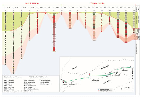
Figure 15.
Correlation of the studied sections in the Errachidia–Boudnib–Erfoud Basin, with other sections in the Ouarzazate and Agadir basins along the Agadir–Tazzouguerte east–west transect. The seven western sections on the transverse are from [17,39,57].
During the Albian–Cenomanian period, the Ifezouane Formation with a mainly fluvial character was deposited over different basements units in the eastern basins. Its equivalent in the western part is the Kechoula Formation, which consists essentially of calcareous facies and some marly intercalations in the distal part of the Agadir Basin (Taghazoute, Tahanaoute, and Askoutti) and red continental silts in the proximal part of the basin (Afansou and Tizi N’Test). During the Cenomanian, the sedimentation continues with the deposits of the Aoufous Formation (red clays, green marls, sandstones, and primary gypsums). This formation is well-developed in the Errachidia–Boudnib–Erfoud Basin and marks the first marine invasion represented by coastal lagoon deposits within the red facies of the alluvial plain. Coeval to the Aoufous Formation, in the Agadir Basin, the Aït Lamine Formation shows purely marine facies represented by green marls, calcarenites, and oyster beds in the distal part of the basin but mainly continental sediments in the proximal part (red siltstones intercalated sometimes with green marls and sandy limestone beds).
During the late Cenomanian, estuarine-related sediments were deposited in the Agadir Basin; these are marls, oyster limestones, and calcarenites. In the eastern basins, the deposits become purely marine and are represented by dolomitic limestones, marly limestones, and lumachellic or bioclastic limestones. During the Turonian, black shales and laminated mudstones developed in the Agadir Basin. In the eastern basins, the facies are composed of dolomitic beds, bedded fine limestones containing chert, and bioclastic limestones. The upper Cenomanian and Turonian deposits correspond to the Casbah d’Agadir Formation in the Agadir Basin and the Akrabou Formation in the eastern basins.
Correlations show that the Cretaceous series is very reduced in Bou Tazoult and Anounizme. In the latter locality, it is represented only by the Ifezouane Formation. The variegated deposits of the Aoufous Formation and those of the Akrabou Formation are absent. Moreover, the Akrabou Formation’s thickness decreases westwards, from the eastern sections where it reaches about 200 m (Tazzouguerte). This decrease in thickness is accentuated in Imiter and Tazoughmite localities where it is reduced to a single bed of 0.5 m. Similarly, the thickness of the Cenomanian–Turonian carbonate unit decreases from the Agadir Basin sections to the east. The thinning of these Cenomanian–Turonian deposits on both sides of Anounizme and their disappearance in this locality suggest the existence of a paleorelief between the two domains. The western basins likely were expressed by a slope towards the west to the Atlantic Ocean, while eastern basins deepened towards the east towards the Tethyan realm via the Sahara (Bechar region). According to [7], the transition between these two domains is likely located in the area between Tinejdad and Goulmima.
A comparison of the two parts of the transect highlights marine flooding, which begins well before the δ13C anomaly recorded at the Cenomanian–Turonian transition in the Agadir Basin [39]. On the eastern part of the transverse, the “Infra-Cenomanian” fluvial series is transgressed by shallow carbonates. The actual marine transgression there begins with the carbonates of the Cenomanian–Turonian transition. This global marine transgression at the eastern basins occurs later, coinciding almost exactly with the beginning of the δ13C anomaly [9,13,14,15].
6. Conclusions
This detailed study, covering the range from the “Infra-Cenomanian” to the Cenomanian-Turonian, shows that in the Errachidia–Boudnib–Erfoud Basin, the studied series begins with red sandstone deposits with oblique laminations, which correspond to the Ifezouane Formation attributed to the Albian. Its middle part consists of alternating red clays, sandstone beds, green marl levels, and primary gypsum forming the Aoufous Formation attributed to the Cenomanian. The series is topped by a carbonate unit, which corresponds to the Akrabou Formation dated to the Cenomanian–Turonian.
The variations recorded, such as the deposits throughout the studied sections, reflect changes in the depositional environments along the basin. Indeed, the Ifezouane Formation with its sandstone deposits shows a fluvial environment. The deposits of the Aoufous Formation attest to an alluvial plain environment that evolves towards a coastal lagoon and then towards a shallow marine environment in its upper part. The Akrabou carbonate Formation, on the other hand, shows a shallow lagoon to an open marine depositional environment.
The complex series underlying the Cenomanian–Turonian platform shows variations in thickness throughout the basin. Thus, it reaches its maximum thickness in Tinghir and reduces strongly towards the west, at Anounizme, Tazoughmite, and Goulmima. These variations in thickness may be related to tectonic movements of the basement. Indeed, the structuring of the latter could be at the origin of the individualization of grabens receptacles for deposits and horsts where the series is strongly thinned.
The Cenomanian–Turonian carbonate platform, on the other hand, shows an opening towards the east of the basin. This is related to the Tethyan transgression during this period. However, it thins from the east to the west until it disappears at Anounizme. The carbonate unit reappears again beyond this locality and thickens towards the Agadir basin. This makes it possible to suppose the existence of a paleorelief, a structural high, during the Cenomanian–Turonian at the Anounizme locality. This paleorelief could be the limit between the Tethyan Errachidia–Boudnib–Erfoud Basin and Atlantic-related Ouarzazate and Agadir basins.
Author Contributions
Conceptualization, I.C., L.K., B.E. and A.C.; methodology, I.C. and B.E.; software, I.C. and B.E.; validation, B.E., A.C., M.A. and C.N.d.C.; formal analysis, I.C.; data curation, I.C.; writing—original draft preparation, I.C., L.K., B.E. and A.C.; writing—review and editing, H.S.M., M.A., K.A., C.N.d.C. and M.S.F.; visualization, I.C.; supervision, L.K. and B.E.; project administration, M.A.; funding acquisition, K.A. and M.S.F. All authors have read and agreed to the published version of the manuscript.
Funding
This research was funded by Researchers Supporting Project number (RSP–2021/249), King Saud University, Riyadh, Saudi Arabia.
Institutional Review Board Statement
Not applicable.
Informed Consent Statement
Not applicable.
Data Availability Statement
The data presented in this study are available upon request from the corresponding author.
Conflicts of Interest
The authors declare no conflict of interest.
References
- Daguin, F. Sur le Crétacé de la Vallée de l’Oued Ziz (Maroc du Sud, confins du Tafilalet). Bull. Soc. Géol. Fr. 1931, 5, 537–545. [Google Scholar]
- Dubar, G.; Despujols, M.P. Carte Géologique Provisoire du Haut-Atlas de Midelt au 1/200,000 e; Service de la Carte Géologique du Maroc: Rabat, Morocco, 1948. [Google Scholar]
- Ambroggi, R.; Choubert, G. Anti-Atlas et vallée du Draa. Hydrogéologie du Maroc. Notes Mém. Serv. Géol. Maroc 1952, 97, 323–335. [Google Scholar]
- Hadri, M. Carte Géologique du Maroc. Feuille de Goulmima 1/100 000. Notice Explicative; Service de la Carte Géologique du Maroc: Rabat, Morocco, 2004. [Google Scholar]
- Cavin, L.; Dutheil, D.B. A new Cenomanian ichthyofauna from southeastern Morocco and its relationships with other early Late Cretaceous Moroccan faunas. Geol. En Mijnb. 1999, 78, 261–266. [Google Scholar] [CrossRef]
- Dutheil, D.B. Les Cladistia du Cénomanien Continental du Sud-Est Marocain et les Ichthyofaunes Associées: Implications Biostratigraphiques, Taphonomiques, Paléoécologiques et Paléobiogéographiques. Ph.D. Thesis, Ecole Pratique des Hautes Etudes, Paris, France, 2000. [Google Scholar]
- Rhalmi, M.; Pascal, A.; Chellai, E.H. Litho-biostratigraphie, diagenèse et paléogéographie au Cénomanien supérieur-Turonien inférieur des bassins sud-atlasiques marocains. Géol. Alp. 2000, 76, 135–149. [Google Scholar]
- Cavin, L.; Boudad, L.; Duffaud, S.; Kabiri, L.; Le Lœuff, J.; Rouget, I.; Tong, H. L’évolution paléoenvironnementale des faunes de poissons du Crétacé supérieur du bassin du Tafilalt et des régions avoisinantes (Sud-Est du Maroc): Implications paléobiogéographiques. C. R. Acad. Sci.-Ser. IIA-Earth Planet. Sci. 2001, 333, 677–683. [Google Scholar] [CrossRef]
- Ettachfini, E.M.; Andreu, B. Le Cénomanien et le Turonien de la Plate-forme Préafricaine du Maroc. Cretac. Res. 2004, 25, 277–302. [Google Scholar] [CrossRef]
- Ettachfini, E.M. La Transgression au Passage du Cénomanien au Turonien sur le Domaine Atlasique Marocain: Stratigraphie Intégrée et Relations Avec L’événement Océanique Global. Ph.D. Thesis, Chouaïb Doukkali University, El Jadida, Morocco, 2006. [Google Scholar]
- Kennedy, W.J.; Gale, A.S.; Ward, D.J.; Underwood, C.J. Early Turonian ammonites from Goulmima, southern Morocco. Bull. Inst. Roy. Sci. Nat. Belg. Sci.Terre 2008, 78, 149–177. [Google Scholar]
- Martill, D.M.; Ibrahim, N.; Brito, P.M.; Baider, L.; Zhouri, S.; Loveridge, R.; Naish, D.; Hing, R. A new Plattenkalk Konservat Lägerstatte in the upper Cretaceous of Gara Sbaa, south-eastern Morocco. Cretac. Res. 2011, 32, 433–446. [Google Scholar] [CrossRef]
- Lézin, C.; Andreu, B.; Ettachfini, E.M.; Wallez, M.-J.; Lebedel, V.; Meister, C. The Upper Cenomanian–Lower Turonian of the Preafrican Trough, Morocco. Sediment. Geol. 2012, 245–246, 1–16. [Google Scholar] [CrossRef]
- Andreu, B.; Lebedel, V.; Wallez, M.-J.; Lézin, C.; Ettachfini, E.M. The upper Cenomanian–lower Turonian carbonate platform of the Preafrican Trough, Morocco: Biostratigraphic, paleoecological and paleobiogeographical distribution of ostracods. Cretac. Res. 2013, 45, 216–246. [Google Scholar] [CrossRef]
- Lebedel, V.; Lezin, C.; Andreu, B.; Wallez, M.-J.; Ettachfini, E.M.; Riquier, L. Geochemical and palaeoecological record of the Cenomanian–Turonian Anoxic Event in the carbonate platform of the Preafrican Trough, Morocco. Palaeogeogr. Palaeoclim. Palaeoecol. 2013, 369, 79–98. [Google Scholar] [CrossRef]
- Krassilov, V.; Bacchia, F. New Cenomanian florule and a leaf mine from southeastern Morocco: Palaeoecological and climatological inferences. Cretac. Res. 2013, 40, 218–226. [Google Scholar] [CrossRef]
- Essafraoui, B.; Ferry, S.; Grosheny, D.; Içame, N.; El Aouli, H.; Masrour, M.; Bulot, L.G.; Géraud, Y.; Aoutem, M. Sequence stratigraphic architecture of marine to fluvial deposits across a passive margin (Cenomanian, Atlantic margin, Morocco, Agadir transect). Carnets Géol. 2015, 15, 137–172. [Google Scholar] [CrossRef][Green Version]
- Meister, C.; Piuz, A.; Cavin, L.; Boudad, L.; Bacchia, F.; Ettachfini, E.M.; Benyoucef, M. Late Cretaceous (Cenomanian-Turonian) ammonites from southern Morocco and south western Algeria. Arab. J. Geosci. 2017, 10, 1. [Google Scholar] [CrossRef]
- Cavin, L.; Boudad, L.; Läng, E.; Tong, H. Vertébrés du Crétacé supérieur basal (Cénomanien-Turonien) du plateau des Hamadas, SE du Maroc. In Paléontologie des Vertébrés du Maroc: État des Connaissances; Zouhri, S., Ed.; Société géologique de France: Paris, France, 2017; Volume 180, pp. 307–349. [Google Scholar]
- Martill, D.M.; Unwin, D.M.; Ibrahim, N.; Longrich, N. A new edentulous pterosaur from the Cretaceous Kem Kem beds of south eastern Morocco. Cretac. Res. 2018, 84, 1–12. [Google Scholar] [CrossRef]
- Jacobs, M.L.; Martill, D.M.; Ibrahim, N.; Longrich, N. A new species of Coloborhynchus (Pterosauria, Ornithocheiridae) from the mid-Cretaceous of North Africa. Cretac. Res. 2019, 95, 77–88. [Google Scholar] [CrossRef]
- Jacobs, M.L.; Martill, D.M.; Unwin, D.M.; Ibrahim, N.; Zouhri, S.; Longrich, N.R. New toothed pterosaurs (Pterosauria: Ornithocheiridae) from the middle Cretaceous Kem Kem beds of Morocco and implications for pterosaur palaeobiogeography and diversity. Cretac. Res. 2020, 110, 104413. [Google Scholar] [CrossRef]
- Lavocat, R. Reconnaissance Géologique dans les Hammadas des Confins Algéro-Marocains du Sud; Édition du Service Géologique du Maroc: Rabat, Morocco, 1955. [Google Scholar]
- Meister, C.; Rhalmi, M. Quelques ammonites du Cénomanien-Turonien de la région d’Errachidia-Boudnid-Erfoud (partie méridionale du Haut Atlas Central, Maroc). Rev. Paléobiol. 2002, 21, 759–779. [Google Scholar]
- Choubert, G.; Dubar, G.; Hindermeyer, J. Carte Géologique du Haut Atlas au nord de Ksar-es-Souk et de Boudenib (Feuilles Rich et Boudenib), au 1/200 000; Service de la Carte Géologique du Maroc: Rabat, Morocco, 1956. [Google Scholar]
- Hindermeyer, J.; Gauthier, H.; Destombes, J.; Choubert, G.; Faure-Muret, A. Carte Géologique du Maroc, Jbel Saghro-Dades (Haut Atlas Central, Sillon Sud-Atlasique et Anti-Atlas Oriental)—Echelle 1/200,000; Service de la Carte Géologique du Maroc: Rabat, Morocco, 1977. [Google Scholar]
- Hadri, M. Carte Géologique du Maroc: Tinejdad, Échelle 1/100,000; Service de la Carte Géologique du Maroc: Rabat, Morocco, 1997. [Google Scholar]
- Hefferan, K.; Soulaimani, A.; Samson, S.D.; Admou, H.; Inglis, J.; Saquaque, A.; Chaib, L.; Heywood, N. A reconsideration of Pan African orogenic cycle in the Anti-Atlas Mountains, Morocco. J. Afr. Earth Sci. 2014, 98, 34–46. [Google Scholar] [CrossRef]
- Schiavo, A.; Taj-Eddine, K.; Algouti, A.; Benvenuti, M.; Dal Piaz, G.V.; Eddebbi, A.; El Boukhari, A.; Laftouhi, N.; Massironi, M.; Moratti, G. Carte Géologique du Maroc au 1/50,000, Feuille Imtir; Service de la Carte Géologique du Maroc: Rabat, Morocco, 2007. [Google Scholar]
- Ellero, A.; Ottria, G.; Malusà, M.G.; Ouanaimi, H. Structural geological analysis of the high atlas (Morocco): Evidences of a transpressional fold-thrust belt. In Tectonics-Recent Advances; Sharkov, E., Ed.; InTech: Rijeka, Croatia, 2012; pp. 230–251. [Google Scholar]
- Sereno, P.C.; Dutheil, D.B.; Iarochene, M.; Larsson, H.C.; Lyon, G.H.; Magwene, P.M.; Wilson, J.A. Predatory dinosaurs from the Sahara and Late Cretaceous faunal differentiation. Science 1996, 272, 986–991. [Google Scholar] [CrossRef]
- Cavin, L.; Tong, H.; Boudad, L.; Meister, C.; Piuz, A.; Tabouelle, J.; Aarab, M.; Amiot, R.; Buffetaut, E.; Dyke, G.; et al. Vertebrate assemblages from the early Late Cretaceous of southeastern Morocco: An overview. J. Afr. Earth Sci. 2010, 57, 391–412. [Google Scholar] [CrossRef]
- Wang, J.; Bulot, L.G.; Taylor, K.G.; Redfern, J. Controls and timing of Cenomanian-Turonian organic enrichment and relationship to the OAE2 event in Morocco, North Africa. Mar. Pet. Geol. 2021, 128, 105013. [Google Scholar] [CrossRef]
- Wiese, F.; Schulze, F. The upper Cenomanian (Cretaceous) ammonite Neolobites vibrayeanus (d’Orbigny, 1841) in the Middle East: Taxonomic and palaeoecologic remarks. Cretac. Res. 2005, 26, 930–946. [Google Scholar] [CrossRef]
- Milhi, A. Carte Géologique du Maroc au 1/100.000. Feuille de Tinerhir (Haut-Atlas Central); Service de la Carte Géologique du Maroc: Rabat, Morocco, 1997. [Google Scholar]
- Rhalmi, M. Les Systèmes Sédimentaires Cénomano-Turoniens et Sénoniens de la Région Manganésifère d’Imini (Haut-Atlas central, Maroc) et Leur Evolution Diagénétique. Ph.D. Thesis, Université de Bourgogne, Dijon, France, 1992. [Google Scholar]
- Destombes, J.; Hollard, H. Carte Géologique du Maroc. Tafilalt–Taouz. Echelle 1/200 000; Service de la Carte Géologique du Maroc: Rabat, Morocco, 1986. [Google Scholar]
- Dunham, R.J. Classification of carbonate rocks according to depositional textures. In Classification of Carbonate Rocks; Ham, W.E., Ed.; AAPG Memoir: Tulsa, OK, USA, 1962; Volume 1, pp. 108–121. [Google Scholar]
- Jati, M.; Grosheny, D.; Ferry, S.; Masrour, M.; Aoutem, M.; Içame, N.; Gauthier-Lafaye, F.; Desmares, D. The Cenomanian–Turonian boundary event on the Moroccan Atlantic margin (Agadir basin): Stable isotope and sequence stratigraphy. Palaeogeogr. Palaeoclim. Palaeoecol. 2010, 296, 151–164. [Google Scholar] [CrossRef]
- Jenny, J.; Le Marrec, A.; Monbaron, M. Les couches rouges du Jurassique moyen du Haut Atlas central (Maroc); Corrélations lithostratigraphiques, éléments de datations et cadre tectono-sédimentaire. Bull. Soc. Géol. Fr. 1981, 7, 627–640. [Google Scholar] [CrossRef]
- Charrière, A.; Haddoumi, H. Les Couches rouges continentales jurassico-crétacées des Atlas marocains (Moyen Atlas, Haut Atlas central et oriental): Bilan stratigraphique, paléogéographies successives et cadre géodynamique. Bol. Geol. Min. 2016, 127, 407–430. [Google Scholar]
- Haddoumi, H.; Charrière, A.; Feist, M.; Andreu, B. Nouvelles datations (Hauterivien supérieur–Barrémien inférieur) dans les couches rouges continentales du Haut Atlas central marocain; conséquences sur l’âge du magmatisme et des structurations mésozoïques de la chaîne Atlasique. C. R. Palevol. 2002, 1, 259–266. [Google Scholar] [CrossRef]
- Haddoumi, H.; Charrière, A.; Mojon, P.O. Stratigraphie et sédimentologie des Couches rouges continentales du Jurassique-Crétacé du Haut Atlas central (Maroc): Implications paléogéographiques et géodynamiques. Geobios 2010, 43, 433–451. [Google Scholar] [CrossRef]
- Du Dresnay, R.; Hindermeyer, J.; Emberger, A.; Caia, J.; Destombes, J.; Hollard, H. Carte Géologique du Maroc au 1/200,000. Feuille Todgha—Ma’der; Service de la Carte Géologique du Maroc: Rabat, Morocco, 1988. [Google Scholar]
- Hejja, Y.; Baidder, L.; Ibouh, H.; Nait Bba, A.; Soulaimani, A.; Gaouzi, A.; Maacha, L. Fractures distribution and basement-cover interaction in a polytectonic domain: A case study from the Saghro Massif (Eastern Anti-Atlas, Morocco). J. Afr. Earth Sci. 2020, 162, 103694. [Google Scholar] [CrossRef]
- Choubert, G. Essai sur la paléogéographie du Mésocrétacé marocain. Vol. Jubil. Soc. Sci. Nat. Maroc. 1948, 1920, 307–329. [Google Scholar]
- Choubert, G.; Faure-Muret, A. Evolution du domaine atlasique marocain depuis les temps paléozoïques. Mém. Soc. Géol. Fr. 1960, 1, 447–527. [Google Scholar]
- Ferrandini, M. Les foraminifères benthiques du cénomanien supérieur dans le sud-est marocain. Rev. Paléobiol. 1988, 86, 429–430. [Google Scholar]
- Ferrandini, M.; Philip, J.; Babinot, J.F.; Ferrandini, J.; Tronchetti, G. La plate-forme carbonatée du Cenomano-Turonien de la region d’Erfoud-Errachidia (Sud-Est marocain); stratigraphie et paléoenvironnements. Bull. Soc. Géol. Fr. 1985, 1, 559–564. [Google Scholar] [CrossRef]
- Al-Masrahy, M.A.; Mountney, N.P. A classification scheme for fluvial–aeolian system interaction in desert-margin settings. Aeolian Res. 2015, 17, 67–88. [Google Scholar] [CrossRef]
- Konotio, I.; Lagnaoui, A.; Chellai, E.H.; Fabuel-Perez, I.; Redfern, J. Reconnaissance des caractères sédimentaires et ichnofaciès des grès triasiques de Tighadwine, Haut-Atlas de Marrackech-Maroc. Bol. Geol. Min. 2016, 127, 361–374. [Google Scholar]
- Benyoucef, M.; Meister, C.; Mebarki, K.; Läng, É.; Adaci, M.; Cavin, L.; Malti, F.-Z.; Djamila, Z.; Bensalah, M. Évolution lithostratigraphique, paléoenvironnementale et séquentielle du Cénomanien-Turonien inférieur dans la région du Guir (Ouest algérien). Carnets Géol. 2016, 16, 271–296. [Google Scholar]
- Benyoucef, M.; Meister, C.; Bensalah, M.; Malti, F.-Z. La plateforme préafricaine (Cénomanien supérieur-Turonien inférieur) dans la région de Béchar (Algérie): Stratigraphie, paléoenvironnements et signification paléobiogéographique. Rev. Paléobiol. 2012, 31, 205–218. [Google Scholar]
- Meister, C.; Alzouma, K.; Lang, J.; Mathey, B. Les ammonites du Niger (Afrique occidentale) et la transgression transsaharienne au cours du Cénomanien-Turonien. Geobios 1992, 25, 55–100. [Google Scholar] [CrossRef]
- Abioui, M.; Ferry, S.; Grosheny, D.; Içame, N.; Robert, E.; Benssaou, M. The Cretaceous marine onlap on Palaeozoic deposits (Smara–Lâayoune Basin, South Morocco). Comparison with neighbouring regions. C. R. Geosci. 2019, 351, 498–507. [Google Scholar] [CrossRef]
- Dutheil, D.B. An overview of the freshwater fish fauna from the Kem Kem beds (Late Cretaceous: Cenomanian) of southeastern Morocco. In Mesozoic Fishes 2-Systematics and Fossil Record; Arratia, G., Schultze, H.-P., Eds.; Verlag Dr. Friedrich Pfeil: München, Germany, 1999; Volume 2, pp. 553–563. [Google Scholar]
- Essafraoui, B. Enregistrement Séquentiel du Cénomano-Turonien des Bassins Sud-Atlasiques sur la Transversale Agadir-Goulmima (Maroc). Ph.D. Thesis, Ibn Zohr University, Agadir, Morocco, 2014. [Google Scholar]
Publisher’s Note: MDPI stays neutral with regard to jurisdictional claims in published maps and institutional affiliations. |
© 2022 by the authors. Licensee MDPI, Basel, Switzerland. This article is an open access article distributed under the terms and conditions of the Creative Commons Attribution (CC BY) license (https://creativecommons.org/licenses/by/4.0/).