
New Data on Paleogeography of Quaternary Coast Sediments of the Rivers of the European North of Russia Using Isotope-Geochemical Methods


Abstract
:1. Introduction
1.1. Paleogeography
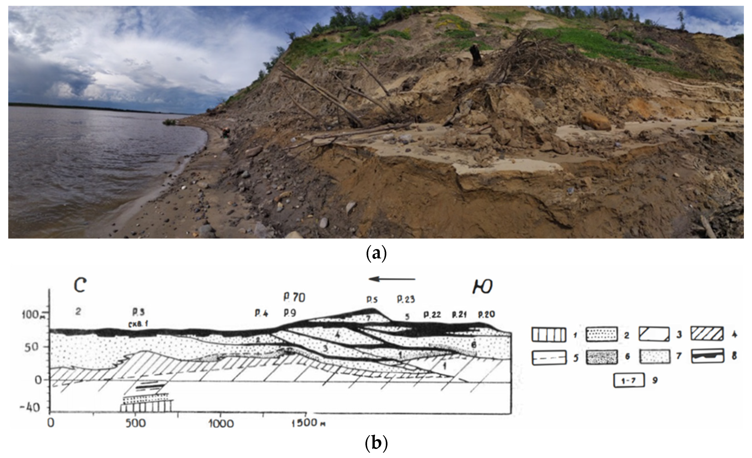
1.2. Geomorphology
2. Materials and Methods
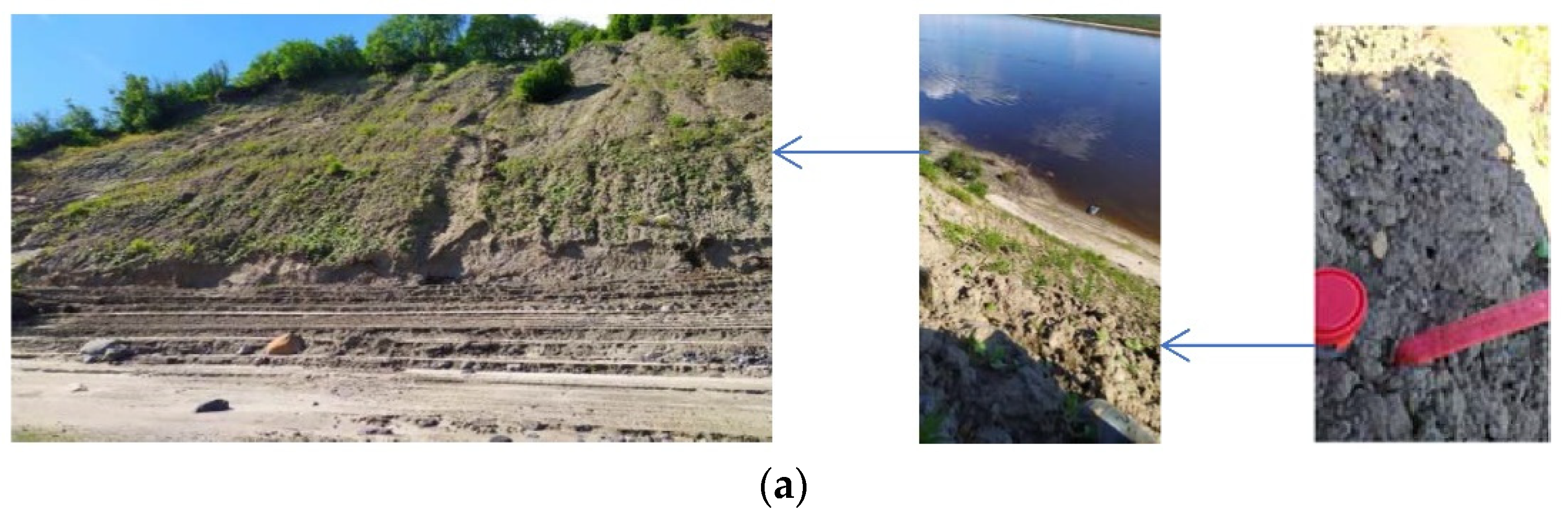
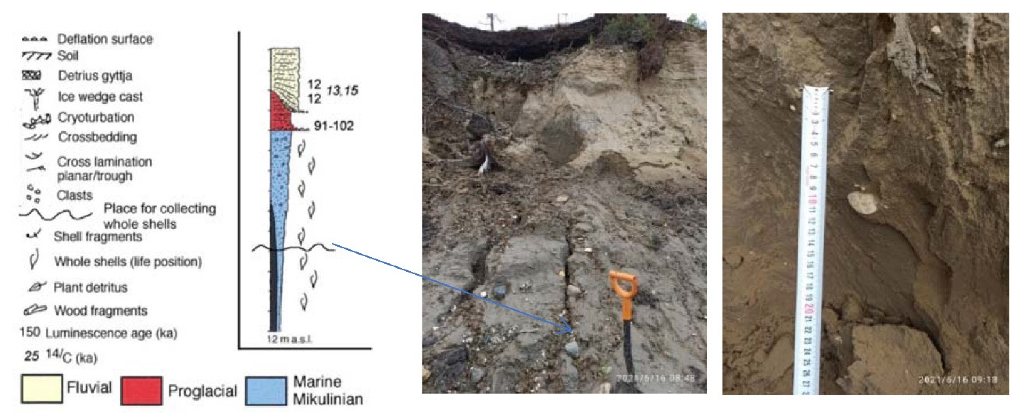
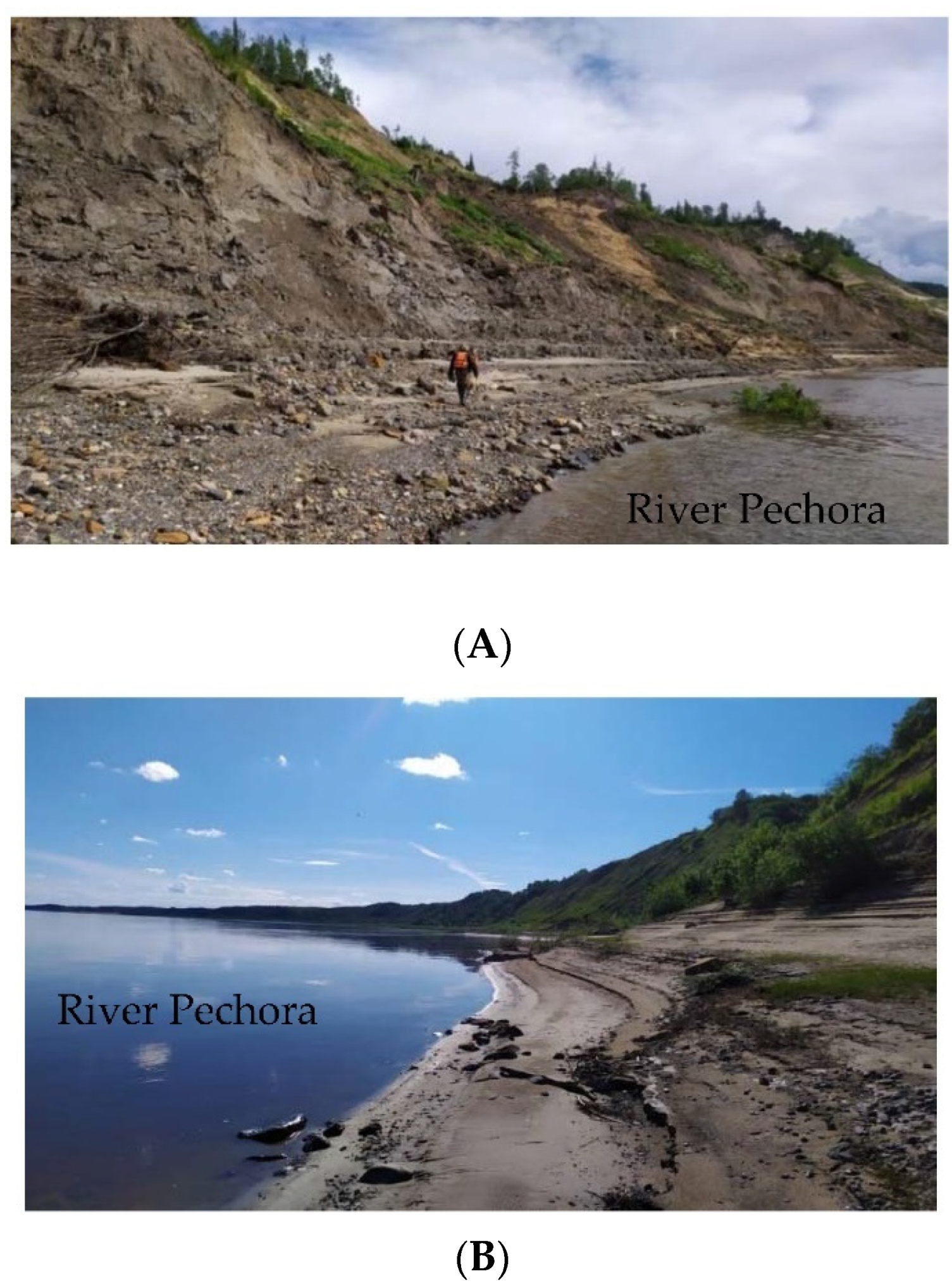
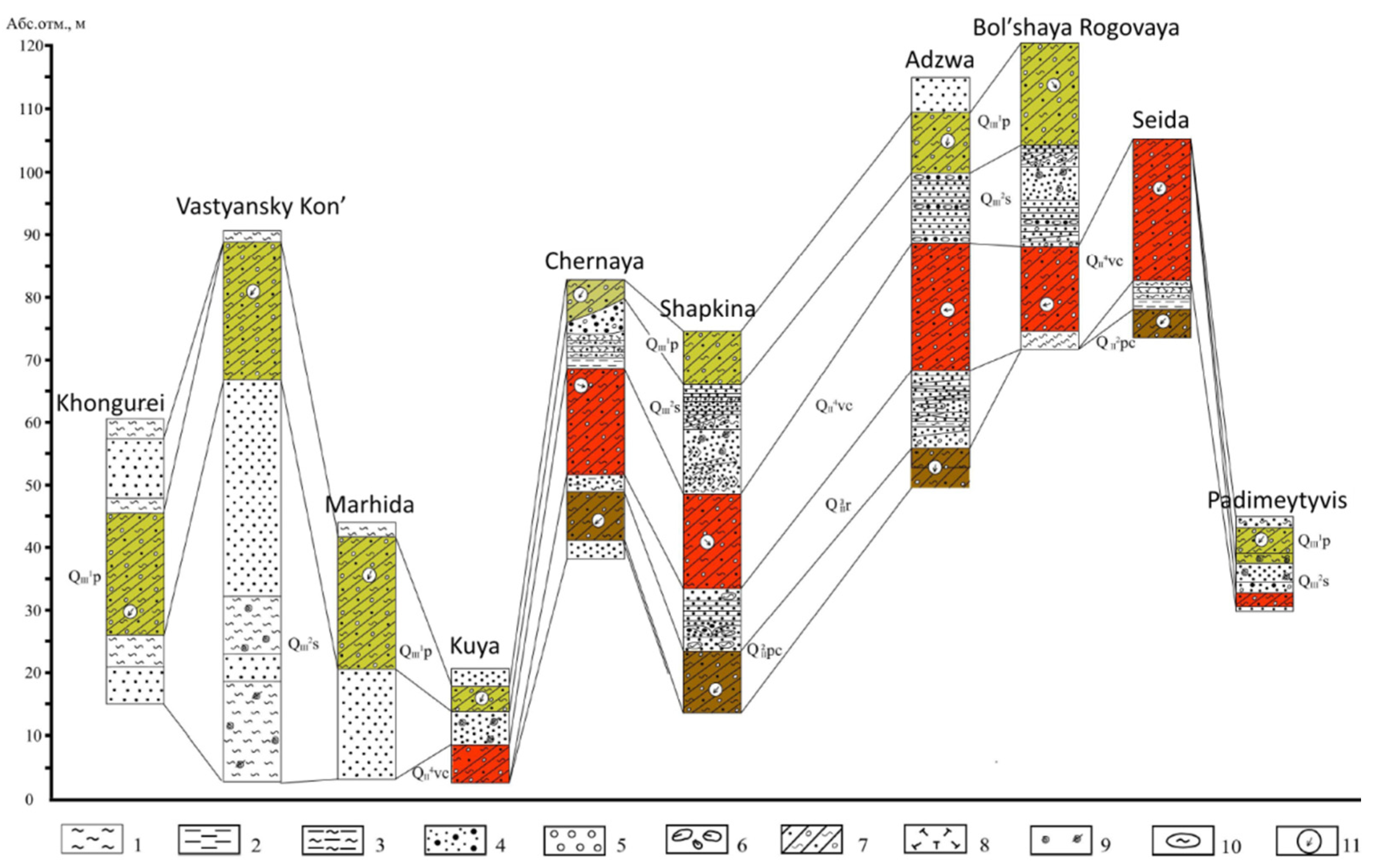
2.1. Sampling Locations
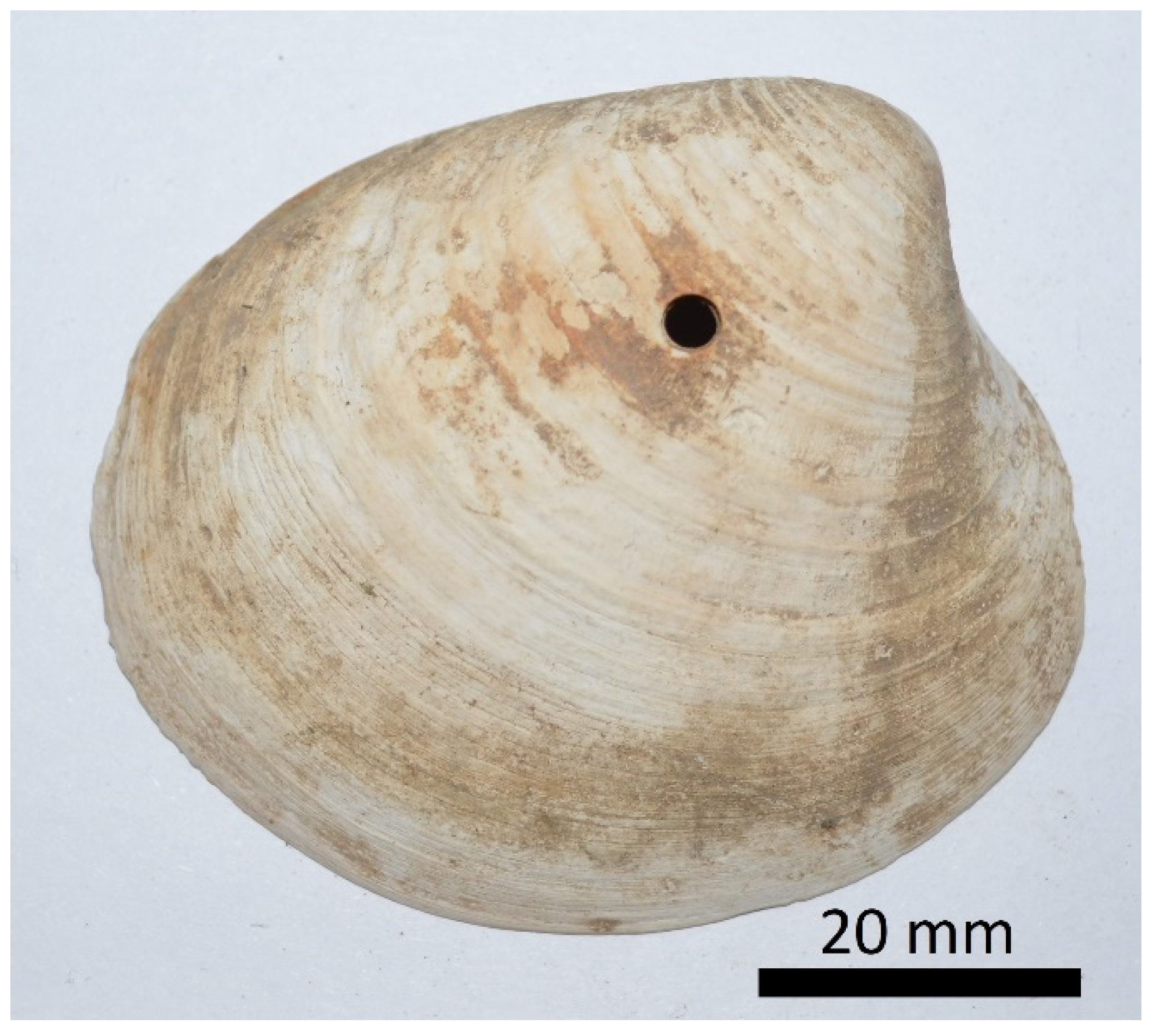
2.2. Selection of Mollusk Shells
2.3. Determination of δ13C and δ18O in Mollusk Shells
2.4. Analysis of the Elemental Composition of Shells
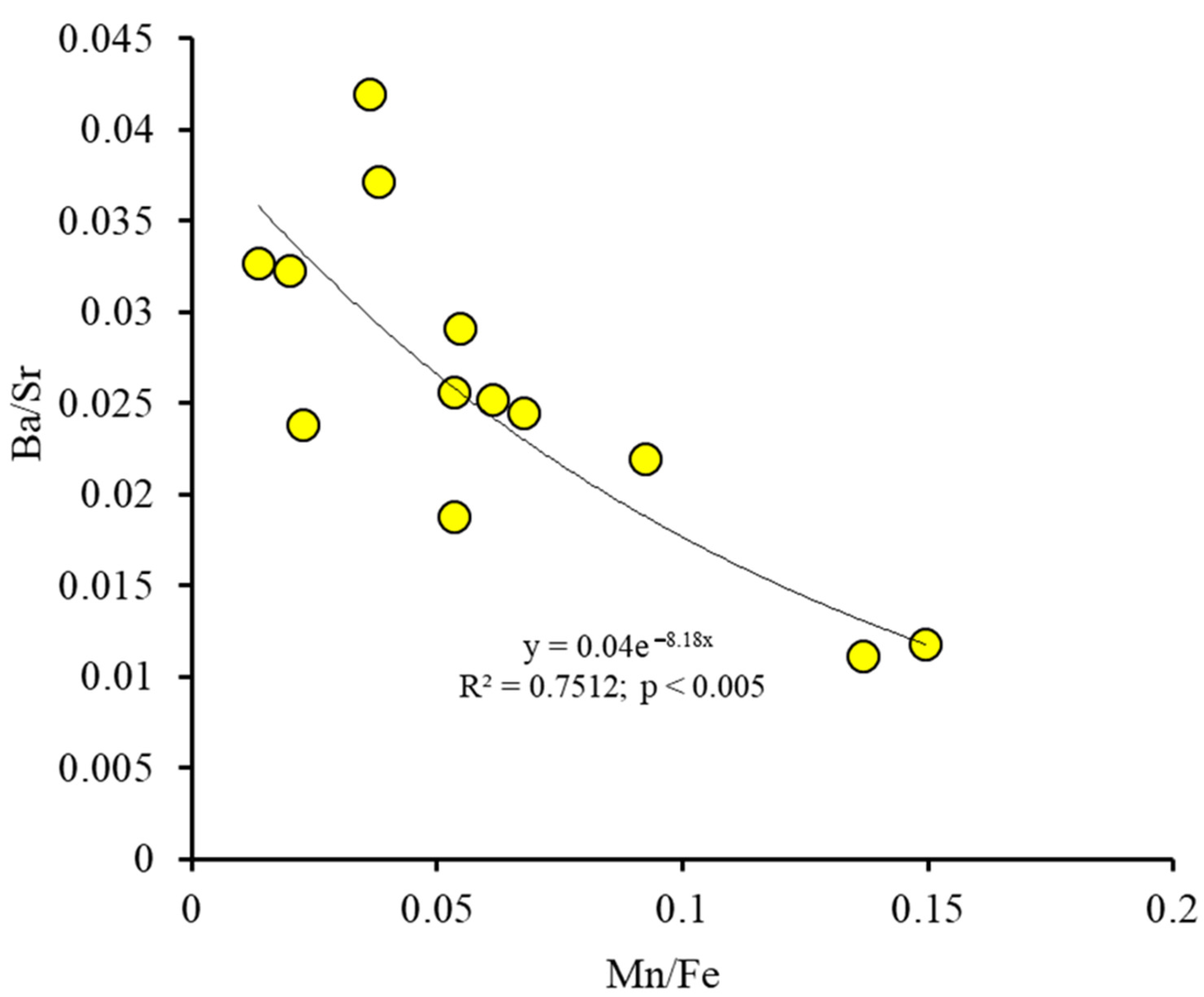
2.5. Statistical Treatment of the Data
3. Results and Discussion


4. Conclusions
Author Contributions
Funding
Institutional Review Board Statement
Informed Consent Statement
Data Availability Statement
Acknowledgments
Conflicts of Interest
References
- Väliranta, M.; Kaakinen, A.; Kuhry, P. Holocene climate and landscape evolution East of the Pechora Delta, East-European Russian Arctic. Quat. Res. 2003, 59, 335–344. [Google Scholar] [CrossRef]
- Arslanov, K.A.; Berdovskaya, G.N.; Loseva, E.I.; Filonov, B.A. New data on continental Mikulinsky deposits in the Lower Pechora. Bull. Leningr. State Univ. 1975, 24, 139–142. [Google Scholar]
- Lavrov, A.S.; Potapenko, L.M. Neopleistocene of the Northeast of the Russian Plain; Aerogeology: Moscow, Russia, 2005; 222p. [Google Scholar]
- Pokrovsky, O.S.; Shirokova, L.S.; Viers, J.; Gordeev, V.V.; Shevchenko, V.P.; Chupakov, A.V.; Vorobieva, T.Y.; Candaudap, F.; Causserand, C.; Lanzanova, A.; et al. Fate of colloids during estuarine mixing in the Arctic. Ocean. Sci. 2014, 10, 107–125. [Google Scholar] [CrossRef] [Green Version]
- Astakhov, V.I.; Svensen, J.I. Cover formation of the final pleistocene in the extreme north-east of European Russia. Reg. Geol. Metallog. 2011, 47, 12–27. [Google Scholar]
- Andreicheva, L.N.; Sudakova, N.G. Reliability assessment of interregional correlation of middle Neopleistocene glacial horizons in the center and north of the Russian plain. Izv. Komi Sci. Cent. Ural Branch Russ. Acad. Sci. 2014, 2, 55–67. [Google Scholar]
- Gray, J. Evolution of the freshwater ecosystem: The fossil record. Palaeogeogr. Palaeoclimatol. Palaeoecol. 1988, 62, 1–214. [Google Scholar] [CrossRef]
- Bolotov, I.N.; Pokrovsky, O.S.; Auda, Y.; Bespalaya, J.V.; Vikhrev, I.V.; Gofarov, M.Y.; Lyubas, A.A.; Viers, J.; Zouiten, C. Trace element composition of freshwater pearl mussels Margaritifera spp. across Eurasia: Testing the effect of species and geographic location. Chem. Geol. 2015, 402, 125–139. [Google Scholar] [CrossRef]
- Vostrukhina, T.M.; Ilyinova, A.A. Biostratigraphy of the Vastyansky Kon’ section on the river. Pechora. In Palynology of the Pleistocene and Pliocene; Nauka: Moscow, Russia, 1973; p. 39. [Google Scholar]
- Fedorov, D.F. Atlas of the Arkhangelsk Region; GUGK: Moscow, Russia, 1976; p. 72. [Google Scholar]
- Loseva, E.I.; Duryagina, D.A. Late Pleistocene Lacustrine Sediments in the Center of the Malozemelskaya Tundra (Soima River Basin). Geology and Minerals of the North-East of the European Part of the USSR. Yearbook; IG Komi Academy of Sciences of the USSR: Syktyvkar, Russia, 1976; pp. 54–61. [Google Scholar]
- Rusanova, G.V. Bolshezemelskaya tundra: A look into the past. Sci. Russ. 2007, 1, 12. [Google Scholar]
- Lukin, A.A.; Dauvalter, V.A.; Novoselov, A.P. Ecosystem of the Pechora River in Modern Conditions; Publishing House of the KSC RAS: Apatity, Russia, 2000; 192p. [Google Scholar]
- Nikolskaya, O.A. Late Pleistocene History of the Hydrographic Network of the Northern Part of the Pechora Basin; Abstract of the Thesis of a Candidate of Geological and Mineralogical Sciences: Saint Petersburg, Russia, 2006; 19p. [Google Scholar]
- Goryachkin, S.V. Soil Cover of the North; TEOS: Moscow, Russia, 2010; 414p. [Google Scholar]
- Simvalova, S.E.; Zarkhidze, V.S. Legend of the Pechora Series of Sheets of the State Geological Map of the Russian Federation M 1:200,000: Explanatory Note, 2nd ed.; All-Russian Research Geological Institute named after A.P.Karpinsky: Ukhta, Russia, 1999; 206p, p. 18. [Google Scholar]
- Dolgov, F.V.; Osadchaya, G.G.; Zengina, T.Y. Comparative assessment of ecosystem functions of representative stows of the southern permafrost zone of the Bolshezemelskaya tundra. Proc. Komi Sci. Cent. Ural Branch Russ. Acad. Sci. 2015, 2, 45–56. [Google Scholar]
- Rusanova, G.V. Soils of tundra and forest landscapes of the transition zone forest-tundra—Southern tundra. Bull. Inst. Biol. Komi Sci. Cent. Ural Branch Russ. Acad. Sci. 2006, 11, 12–15. [Google Scholar]
- Zengina, T.Y.; Osadchaya, G.G.; Parada, N.N. Biospheric functions of the cryolithozone of the Timan-Pechora oil and gas province under conditions of industrial development. Vestn. RUDN 2011, 3, 32–38. [Google Scholar]
- Astakhova, I.S. Timan ridge: The history of the discovery of the mountain system and the emergence of the oronym. Quest. Hist. Nat. Sci. Technol. 2017, 38, 433–447. [Google Scholar]
- Fedorov, V.M. Morphometric features of large-clastic material of modern coastal deposits of the Malozemelskaya tundra. Bull. Mosc. State Univ. M. V. Lomonosov. 1991, 3, 109–112. [Google Scholar]
- Khloptseva, E.V.; Dauvalter, V.A. Pollution of bottom sediments of the lakes of the Bolshezemelskaya tundra. Tr. Fersman Sci. Sess. 2006, 3, 197–199. [Google Scholar]
- Dauvalter, V.A.; Kashulin, N.A. Hydrochemistry of the lakes of the Bolshezemelskaya tundra. Meteorol. Hydrol. 2017, 8, 93–104. [Google Scholar]
- Kulyugina, E.E. Vegetation cover dynamics of sandy outcrops in the east of the Malozemelskaya tundra. In Proceedings of the All-Russian Youth Scieentific Conference on Actual Problems of Biology, Syktyvkar, Russia, 14–16 April 1999; pp. 116–117. [Google Scholar]
- Delta, P. Pechora Delta: Structure and Dynamics of the Pechora Delta Ecosystems (1995–1999); van Eerden, M.R., Ed.; RIZA: Lelystad, The Netherlands, 2000; 367p. [Google Scholar]
- Andreev, V.N. Vegetation Cover of the Eastern European Tundra and Measures for Its Use and Transformation. Ph.D. Thesis, Botanical Institute V.L. Komarov, Leningrad, Russia, 1954; 39p. [Google Scholar]
- Malakhov, A.A. On the stratigraphy of the quaternary deposits of the basin of the middle course of the Mezen and Pyoza rivers. News State Geogr. Soc. 1934, 66, 469–479. [Google Scholar]
- Arslanov, K.A.; Lavrov, A.S.; Nikiforova, L.D. On the paleogeography and geochronology of the late glacial in the north of the Pechora Lowland. Bull. Leningr. State Univ. 1975, 12, 86–93. [Google Scholar]
- Routh, J.; Hugelius, G.; Kuhry, P.; Filley, T.; Kaislahti Tillman, P.; Becher, M.; Crill, P. Soil organic matter characteristics in permafrost terrain, European Russian Arctic: Lability, storage, and impact of thawing. Chem. Geol. 2014, 368, 104–117. [Google Scholar] [CrossRef] [Green Version]
- Pastukhov, A.V.; Kaverin, D.A.; Goncharova, N.N. Relic hilly permafrost peatlands at the southern limit of the Eastern European cryolithozone. Theor. Appl. Ecol. 2015, 1, 77–86. [Google Scholar]
- Kulyugina, E.E. Flora and Vegetation of Sandy Outcrops of the Pripechora Tundra: Dissertation for the Degree of Candidate of Biological Sciences: Syktyvkar, Russia. 2004. Available online: https://elibrary.ru/item.asp?id=16020340 (accessed on 30 March 2022).
- Loseva, E.I. The eternal question—A glacier or a sea? On the example of the study of sections in the basin of the river More-Yu, Bolshezemelskaya tundra. Byul. Comm. Study Quat. Period 2012, 72, 153–162. [Google Scholar]
- Zarkhidze, D.V.; Gusev, E.A.; Anikina, N.Y.; Bartova, A.V.; Gladenkov, A.Y.; Derevyanko, L.G.; Krylov, A.V.; Tverskaya, L.A. New data on the stratigraphy of the Pliocene-quaternary deposits of the river basin. Sea-yu (Bolshezemelskaya tundra). Tr. VNII Oceanol. 2010, 210, 96–110. [Google Scholar]
- Petrov, O.V.; Morozov, A.F.; Chepkasova, T.V.; Strelnikov, S.I.; Bogdanov, Y.B.; Verbitsky, V.R.; Volsky, A.S.; Zastrozhnov, A.S.; Gusev, N.I.; Zhdanov, A.V. (Eds.) Geological Map of Russia and Adjacent Water Areas. Scale: 1:25,000,000; Rosnedra: Moscow, Russia, 2016. [Google Scholar]
- Afanasiev, B.L.; Belkin, V.I. Problems of Cenozoic Geology of the Bolshezemelskaya Tundra. Cenozoic Cover of the Bolshezemelskaya Tundra; Moscow State University: Moscow, Russia, 1963; pp. 4–9. [Google Scholar]
- Goldina, L.P. Geography of the Lakes of the Bolshezemelskaya Tundra; Nauka: Leningrad, Russia, 1972; p. 100. [Google Scholar]
- Vodolazskaya, V.P.; Oparenkova, L.I.; Zarkhidze, D.V.; Ivanov, N.F. (Eds.) State Geological Map of the Russian Federation. Scale 1:1,000,000 (Third Generation); Ural Series; Sheet Q-40, Pechora, Explanatory Letter; Cartographic Factory VSEGEI: Saint Petersburg, Russia, 2013; 365p. [Google Scholar]
- Golbert, A.B.; Gudina, V.I.; Zudin, A.N.; Sukhorukova, S.S.; Troitsky, S.L.; Yudkevich, A.I. New Data on the Age and Genesis of Quaternary Deposits in the Outcrop Vastyansky Kon’ on the River. Pechora. Pleistocene of Siberia and Adjacent Regions; Nauka: Moscow, Russia, 1973; pp. 151–178. [Google Scholar]
- Andreicheva, L.N.; Vorobyov, N.N. Formation of the lithological composition of Neopleistocene moraines in the extreme north-east of the European Subarctic of Russia. News Komi Sci. Cent. Ural Branch Russ. Acad. Sci. 2019, 3, 23–35. [Google Scholar]
- Khomutova, V.I.; Davydova, N.N.; Raukas, A.V.; Rumjantsev, V.A. History of the Pleistocene Lakes of the East European Plain; History of Lakes; Nauka: Saint Petersburg, Russia, 1998; 406p. [Google Scholar]
- Andreicheva, L.N. Pleistocene of the European Northeast; Ural Branch of the Russian Academy of Sciences: Ekaterinburg, Russia, 2002; 322p. [Google Scholar]
- Geology of the USSR. Arkhangelsk, Vologda Regions and Komi ASSR; State Scientific and Technical Publishing House of Literature on Geology and Protection of Mineral Resources: Moscow, Russia, 1963; Volume 2, 1080p.
- Zarkhidze, V.S. Padimei strata of the western and central regions of the Timano-Ural region. Questions of stratigraphy and correlation of Pliocene and Pleistocene deposits of the northern and southern parts of the Cis-Urals. Ufa. Bashkiria 1972, 1, 56–66. [Google Scholar]
- Danilov, I.D. Pleistocene deposits of the east of the Bolshezemelskaya tundra and the conditions of their formation. Izv. Akad. Nauk. SSSR Ser. Geogr. 1962, 6, 74–80. [Google Scholar]
- Andreicheva, L.N.; Marchenko-Vagapova, T.I.; Buravskaya, M.N.; Golubev, Y. Natural Environment of the Neopleistocene and Holocene in the European North-East of Russia; GEOS: Moscow, Russia, 2015; p. 224. [Google Scholar]
- Lavrushin, Y.A.; Chistyakova, I.A.; Gaidamanchuk, A.S.; Golubev, Y.K.; Vasiliev, V.P. Structure and material composition of deposits of the Bolshezemelskaya tundra glacial paleoshelf. Lithol. Cenozoic Depos. 1989, 3–51. [Google Scholar]
- Svendsen, J.I.; Astakhov, V.I.; Bolshiyanov, D.Y.; Demidov, I.; Dowdeswell, J.A.; Gataullin, V.; Hjort, C.; Hubberten, H.W.; Larsen, E.; Mangerud, J.A.N.; et al. Maximum extent of the Eurasian ice sheets in the Barents and Kara Sea region during the Weichselian. Boreas 1999, 28, 234–242. [Google Scholar] [CrossRef]
- Astakhov, V.I. Late glacial events in the central Russian Arctic. Quat. Int. 1997, 41, 17–25. [Google Scholar] [CrossRef]
- Forman, S.L.; Ingolfsson, O.; Gataullin, V.N.; Manley, W.F.; Lokrantz, H. Late quaternary strarigraphy of western Yamal Peninsula, Russia: New constraints on the configuration of the Eurasian ice sheet. Geology 1999, 27, 807–810. [Google Scholar] [CrossRef] [Green Version]
- Naish, T.; Zwartz, D. Looking back to the future. Nat. Clim. Chang. 2012, 2, 317–318. [Google Scholar] [CrossRef]
- Danukalova, G.A. Paleontology in Tables: Methodological Guidance; GERS: Tver, Russia, 2009; p. 196. [Google Scholar]
- Yanin, B.T. Fundamentals of Taphonomy; Nedra: Moscow, Russia, 1983; p. 184. [Google Scholar]
- Karandashev, V.K.; Turanov, A.N.; Orlova, T.A.; Lezhnev, A.E.; Nosenko, S.V.; Zolotareva, N.I.; Moskvina, I.R. Application of mass-spectrometry with inductively coupled plasma to elemental analysis of environmental objects. Ind. Lab. Diagn. Mater. 2007, 73, 12–22. [Google Scholar]
- Lavrova, M.A.; Troitsky, S.L. Interglacial transgressions in the north of Europe and Siberia. In Chronology and climates of the Quaternary period. In Proceedings of the International Geological Congress, Copenhagen, Denmark, 15–25 August 1960; pp. 124–136. [Google Scholar]
- Zarkhidze, V.S.; Krasnov, I.I.; Spiridonov, M.A.; Lavrushin, Y.A.; Ryumina, I.I. The main sections of the lower Pechora and their significance for understanding the last stages of the geological development of the northeast of the European part of the USSR. In The Arctic Ocean and Its Coast in the Cenozoic; Gidrometeoizdat: Leningrad, Russia, 1970; pp. 336–338. [Google Scholar]
- Fedorov, V.M. Morphometric analysis of coarse clastic material of the Cenozoic deposits of the section “Vastyansky Kon”. Bull. Mosc. Univ. Ser. 5 Geogr. 1993, 3, 75–80. [Google Scholar]
- Ponomarev, D.V. Reference sections of the Pleistocene and the main localities of the remains of Quaternary mammals of the Pechora River. In Proceedings of the “Integrated Pechora Expedition”; Izvestia of the Komi Republican Branch of the Russian Geographical Society: Syktyvkar, Russia, 2016; pp. 70–72. [Google Scholar]
- Available online: https://www.vsegei.ru/ru/about/news/98232/ (accessed on 30 March 2022).
- Epshtein, O.G. Outcrop Vastyansky Kon’ on the Lower Pechora section of a thick finite moraine structure in the active marginal zone of the Novaya Zemlya ice cover. Bull. Comm. Study Quat. Period 1990, 59, 14–28. [Google Scholar]
- Yankovsky, V.M. The main results of the study of Quaternary deposits and geomorphology of the Maloxemelskaya tundra. INQUA 1939, 4, 35–39. [Google Scholar]
- Zastrozhnov, A.A.; Zastrozhnov, D.A. Glaciotectonic Complex at the Vastyanskiy Kon Outcrop, NE European Russia: Subglacial or Proglacial Deformations. Available online: https://www.researchgate.net/publication/340174700_A_glaciotectonic_complex_at_the_Vastyanskiy_Kon_outcrop_NE_European_Russia_subglacial_or_proglacial_deformations (accessed on 30 March 2022).
- Lavrushin, Y.A.; Epstein, O.G. Pleistocene geological events of northeastern Europe and southern Barents Sea (recorded in naturally occurring key sections). Bull. Comm. Quat. Stud. Russ. Acad. Sci. 2001, 64, 35–50. [Google Scholar]
- Henriksen, M.; Mangerud, J.; Maslenikova, O.; Matiouchkov, A.; Tveranger, J. Weichselian stratigraphy and glaciotectonic deformation along the lower Pechora River, Arctic Russia. Glob. Planet. Chang. 2001, 31, 297–319. [Google Scholar] [CrossRef]
- Kriauciunas, V.V.; Iglovsky, S.A.; Lyubas, A.A.; Kuznetsova, I.A.; Kotova, E.I.; Shakhova, E.V.; Mironenko, K.A. New data on the paleogeography of the eastern coast of the Grönfjord Bay (western Spitsbergen Island) based on the study of Holocene deposits at Cape Finniset using isotope-geochemical methods. Bull. Tomsk Polytech. Univ. Eng. Georesources 2020, 331, 171–183. [Google Scholar] [CrossRef] [Green Version]
- Svitoch, A.A. Marine Pleistocene of the Coasts of Russia; GEOS: Moscow, Russia, 2003; 362p. [Google Scholar]
- Maksimov, A.V. Lithological and facies characteristics of the sections Semzha, Zaton, Bychye (Lower reaches of the Mezen River, Arkhangelsk Region). In Proceedings of the II International Scientific and Practical Conference of Young Scientists and Specialists in Memory of Academician A.P. Karpinsky, Saint Petersburg, Russia, 8–11 February 2011; pp. 29–32. [Google Scholar]
- Taldenkova, E.E.; Stepanova, A.Y.; Ovsepyan, Y.S.; Baukh, K.A.; Rudenko, O.V. Changes in the paleoenvironment of the northeastern part of the White Sea in the Late Zaalian-Early Eemian time based on the materials of a comprehensive study of the Bychye section, R. Pyoza. Actual problems of paleogeography and stratigraphy of the Pleistocene. In Proceedings of the All-Russian Conference, Altai, Russia, 27–31 July 2015; pp. 205–206. [Google Scholar]
- Demidov, I.N.; Larsen, E.A.; Kyaer, K.K.; Howmark-Nielsen, M. Upper Pleistocene stratigraphy of the southern part of the Belomorian Basin. Reg. Geol. 2007, 30, 179–189. [Google Scholar]
- Grøsfjeld, K.; Funder, S.; Seidenkrantz, M.-S.; Glaister, C. Last interglacial marine environments in the White Sea region, northwestern Russia. Boreas 2006, 35, 493–520. [Google Scholar]
- Jensen, M.A.; Demidov, I.N.; Larsen, E.; Lyså, A. Quaternary palaeoenvironments and multi-storey valley fill architecture along the Mezen and Severnaya Dvina river valleys, Arkhangelsk region, NW Russia. Quat. Sci. Rev. 2009, 28, 2489–2506. [Google Scholar] [CrossRef]
- Houmark-Nielsen, M.; Demidov, I.; Lavrova, N.; Funder, S.; Kjær, K.H.; Nielsen, J.K.; Grøsfjeldd, K.; Larsen, E.; Lyså, A. Early and middle valdaian glaciations, ice-dammed lakes and periglacial interstadials in northwest Russia: New evidence from the Pyoza river area. Glob. Planet. Chang. 2001, 31, 215–237. [Google Scholar] [CrossRef]
- Molodkov, A.N. Experience in Using the EPR Method for Dating Mollusk Shells from Quaternary Deposits. Quaternary: Stratigraphy; Nauka: Moscow, Russia, 1989; pp. 204–211. [Google Scholar]
- Sklyarov, E.V.; Gladkochub, D.P.; Donskaya, T.P.; Ivanov, A.P.; Letnikova, E.F.; Mironov, A.G.; Barash, I.G.; Bulanov, V.A.; Sizykh, A.I. Interpretation of Geochemical Data; Intermet-Engineering: Moscow, Russia, 2001; 288p. [Google Scholar]
- Naeher, S.; Gilli, A.; North, R.P.; Hamann, Y.; Schubert, C.J. Tracing bottom water oxygenation with sedimentary Mn/Fe ratios in Lake Zurich, Switzerland. Chem. Geol. 2013, 352, 125–133. [Google Scholar] [CrossRef]


| Locality | River Basin | Coordinates | Number of Samples |
|---|---|---|---|
| Kotkino village | Sula | 67°0′57.76′′ N 50°52′37.02′′ E | 100 |
| 10 km north-west of the Oksino village | Pechora | 67°39′42.88′′ N 52°20′19.25′′ E | 36 |
| Khongurei village | Pechora | 67°33′4.21′′ N 51°56′15.50′′ E | 59 |
| Vastyansky Kon’ | Pechora | 67°15′31.61′′ N 52°12′0.07′′ E | 200 |
| Bychye village | Peza | 65°47′14.61′′ N 44°59′55.33′′ E | 300 |
| Location | d18O | d13C |
|---|---|---|
| River Sula | 34.60 | 1.36 |
| 34.78 | 1.36 | |
| Vastyansky Kon’ (River Pechora) | 34.05 | 1.24 |
| 33.76 | 1.15 | |
| 34.60 | 1.44 | |
| Peza river (Bychye) | 35.34 | 1.35 |
| 35.38 | 1.30 | |
| River Sula | 34.61 | 1.28 |
| Vastyansky Kon’ (River Pechora) | 34.34 | 1.53 |
| 34.38 | 1.37 | |
| 34.43 | 1.36 |
| Sample | Li | Na | Mg | Al | S | K | Mn | Fe |
|---|---|---|---|---|---|---|---|---|
| Sula | 0.40 | 4906.18 | 163.04 | 10.21 | 674.01 | 46.81 | 25.39 | 185.71 |
| Sula | 0.39 | 5264.65 | 54.10 | 32.60 | 220.72 | 42.89 | 6.84 | 125.26 |
| Sula | 0.38 | 5085.41 | 63.03 | 10.21 | 226.37 | 13.45 | 4.13 | 113.83 |
| Sula | 0.51 | 4369.46 | 145.95 | 33.44 | 621.37 | 75.28 | 25.10 | 167.79 |
| Sula | 0.39 | 5249.16 | 53.24 | 10.21 | 216.16 | 28.65 | 7.72 | 202.65 |
| Vastyansky Kon’ | 0.42 | 5163.96 | 69.78 | 35.38 | 427.93 | 44.85 | 8.17 | 403.32 |
| Vastyansky Kon’ | 0.38 | 4918.35 | 111.97 | 102.04 | 356.69 | 73.11 | 5.24 | 389.45 |
| Vastyansky Kon’ | 0.51 | 5461.58 | 107.68 | 26.77 | 525.89 | 63.21 | 9.28 | 173.18 |
| Vastyansky Kon’ | 0.39 | 5929.58 | 176.60 | 33.73 | 662.39 | 58.57 | 6.43 | 119.94 |
| Vastyansky Kon’ | 0.51 | 6109.92 | 626.65 | 47.65 | 1187.80 | 85.38 | 7.87 | 348.67 |
| Vastyansky Kon’ | 0.43 | 5963.88 | 177.33 | 10.21 | 365.38 | 53.05 | 9.40 | 101.70 |
| Peza | 0.35 | 4930.52 | 55.09 | 10.21 | 326.77 | 41.65 | 8.65 | 140.85 |
| Peza | 0.36 | 4830.94 | 67.07 | 23.55 | 359.84 | 45.26 | 10.12 | 149.53 |
| Sample | Cu | Zn | Rb | Sr | Y | Zr | Nb | V |
| Sula | 1.13 | 0.62 | 0.05 | 1651.71 | 2.24 | 0.66 | 0.094 | 0.38 |
| Sula | 1.77 | 1.89 | 0.07 | 1342.79 | 0.89 | 0.47 | 0.19 | 1.63 |
| Sula | 0.75 | 0.27 | 0.04 | 1442.38 | 0.58 | 0.51 | 0.18 | 0.38 |
| Sula | 0.69 | 0.27 | 0.04 | 1341.25 | 1.29 | 0.47 | 0.12 | 0.38 |
| Sula | 0.30 | 3.04 | 0.10 | 1612.91 | 2.33 | 0.09 | 0.09 | 0.38 |
| Vastyansky Kon’ | 0.81 | 1.41 | 0.15 | 1507.13 | 0.26 | 0.18 | 0.28 | 1.74 |
| Vastyansky Kon’ | 2.10 | 6.79 | 0.20 | 1213.19 | 0.67 | 0.41 | 0.21 | 2.61 |
| Vastyansky Kon’ | 1.24 | 1.99 | 0.12 | 1271.48 | 0.86 | 0.29 | 0.18 | 0.38 |
| Vastyansky Kon’ | 1.44 | 1.28 | 0.15 | 1128.31 | 2.26 | 0.28 | 0.10 | 1.25 |
| Vastyansky Kon’ | 1.53 | 0.27 | 0.13 | 2275.39 | 1.05 | 0.34 | 0.21 | 1.93 |
| Vastyansky Kon’ | 0.30 | 0.27 | 0.10 | 1393.67 | 0.81 | 0.17 | 0.16 | 0.38 |
| Peza | 1.15 | 4.45 | 0.09 | 1527.25 | 0.69 | 0.57 | 0.19 | 0.38 |
| Peza | 1.37 | 3.81 | 0.08 | 1571.75 | 0.82 | 0.89 | 0.14 | 0.38 |
| Sample | Sn | Ba | La | Ce | Pr | Nd | Sm | Eu |
| Sula | 0.13 | 18.27 | 3.31 | 4.72 | 0.67 | 3.11 | 0.61 | 0.14 |
| Sula | 0.15 | 39.00 | 3.15 | 5.60 | 0.73 | 3.13 | 0.53 | 0.10 |
| Sula | 0.03 | 60.44 | 1.04 | 2.01 | 0.23 | 0.97 | 0.19 | 0.04 |
| Sula | 0.09 | 49.74 | 4.14 | 7.67 | 0.89 | 3.83 | 0.72 | 0.15 |
| Sula | 0.03 | 19.01 | 3.75 | 5.17 | 0.74 | 3.32 | 0.64 | 0.14 |
| Vastyansky Kon’ | 0.30 | 39.57 | 1.77 | 3.40 | 0.37 | 1.57 | 0.30 | 0.07 |
| Vastyansky Kon’ | 0.10 | 32.56 | 2.02 | 3.60 | 0.40 | 1.77 | 0.30 | 0.06 |
| Vastyansky Kon’ | 0.08 | 21.16 | 3.05 | 5.97 | 0.67 | 3.00 | 0.61 | 0.14 |
| Vastyansky Kon’ | 0.03 | 54.13 | 3.10 | 4.94 | 0.56 | 2.64 | 0.43 | 0.09 |
| Vastyansky Kon’ | 0.16 | 30.57 | 2.21 | 3.71 | 0.44 | 1.99 | 0.32 | 0.07 |
| Peza | 0.13 | 38.49 | 2.73 | 4.61 | 0.53 | 2.34 | 0.45 | 0.09 |
| Peza | 0.29 | 38.42 | 3.32 | 5.74 | 0.65 | 2.92 | 0.57 | 0.11 |
| Sample | Nd | Ti | Hf | Pb | Th | U | Ba/Sr | Mn/Fe |
| Sula | 3.13 | 5.81 | 0.24 | 0.14 | 0.02 | 0.63 | 0.01 | 0.17 |
| Sula | 0.97 | 5.01 | 0.09 | 0.46 | 0.06 | 0.67 | 0.03 | 0.05 |
| Sula | 3.90 | 4.28 | 0.20 | 0.87 | 0.02 | 0.85 | 0.04 | 0.03 |
| Sula | 3.11 | 1.89 | 0.09 | 1.78 | 0.07 | 0.66 | 0.04 | 0.04 |
| Sula | 3.32 | 8.46 | 0.16 | 0.30 | 0.03 | 0.79 | 0.01 | 0.15 |
| Vastyansky Kon’ | 0,80 | 8.21 | 0.10 | 0.20 | 0.02 | 0.24 | 0.03 | 0.02 |
| Vastyansky Kon’ | 1.57 | 10.16 | 0.32 | 0.72 | 0.05 | 0.27 | 0.03 | 0.01 |
| Vastyansky Kon’ | 1.77 | 6.01 | 0.15 | 0.28 | 0.03 | 0.53 | 0.02 | 0.05 |
| Vastyansky Kon’ | 3.00 | 9.96 | 0.13 | 0.31 | 0.03 | 0.68 | 0.02 | 0.05 |
| Vastyansky Kon’ | 2.64 | 15.99 | 0.01 | 0.25 | 0.02 | 0.55 | 0.02 | 0.02 |
| Vastyansky Kon’ | 2.00 | 7.59 | 0.16 | 0.21 | 0.01 | 0.55 | 0.02 | 0.09 |
| Peza | 2.34 | 6.67 | 0.16 | 0.24 | 0.06 | 0.39 | 0.02 | 0.06 |
| Peza | 2.92 | 14.01 | 0.10 | 0.22 | 0.08 | 0.42 | 0.02 | 0.07 |
Publisher’s Note: MDPI stays neutral with regard to jurisdictional claims in published maps and institutional affiliations. |
© 2022 by the authors. Licensee MDPI, Basel, Switzerland. This article is an open access article distributed under the terms and conditions of the Creative Commons Attribution (CC BY) license (https://creativecommons.org/licenses/by/4.0/).
Share and Cite
Iglovsky, S.; Lubas, A.; Yakovlev, E. New Data on Paleogeography of Quaternary Coast Sediments of the Rivers of the European North of Russia Using Isotope-Geochemical Methods. Appl. Sci. 2022, 12, 6988. https://doi.org/10.3390/app12146988
Iglovsky S, Lubas A, Yakovlev E. New Data on Paleogeography of Quaternary Coast Sediments of the Rivers of the European North of Russia Using Isotope-Geochemical Methods. Applied Sciences. 2022; 12(14):6988. https://doi.org/10.3390/app12146988
Chicago/Turabian StyleIglovsky, Stanislav, Artem Lubas, and Evgeny Yakovlev. 2022. "New Data on Paleogeography of Quaternary Coast Sediments of the Rivers of the European North of Russia Using Isotope-Geochemical Methods" Applied Sciences 12, no. 14: 6988. https://doi.org/10.3390/app12146988
APA StyleIglovsky, S., Lubas, A., & Yakovlev, E. (2022). New Data on Paleogeography of Quaternary Coast Sediments of the Rivers of the European North of Russia Using Isotope-Geochemical Methods. Applied Sciences, 12(14), 6988. https://doi.org/10.3390/app12146988