
Comparison of Methods for Reconstructing MODIS Land Surface Temperature under Cloudy Conditions


Abstract
:1. Introduction
2. Materials and Methods
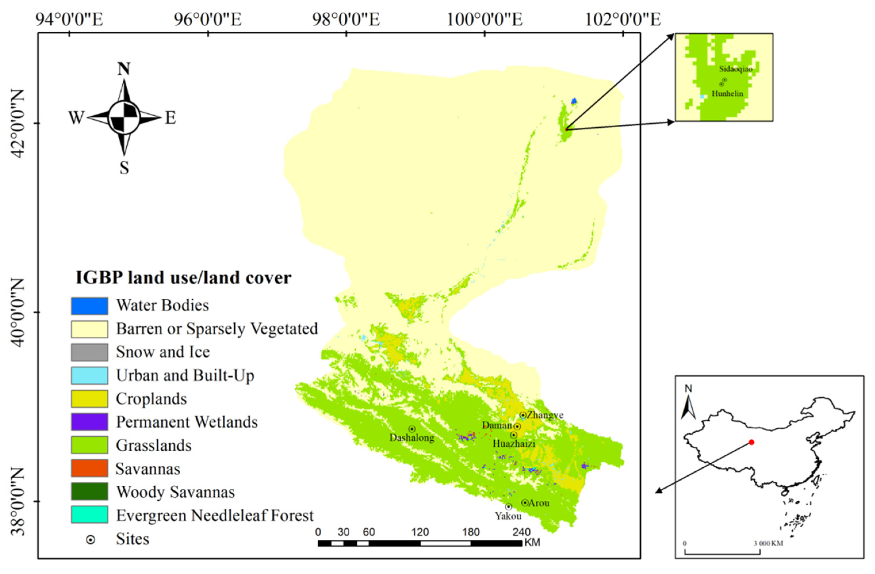
2.1. Study Area
2.2. AWS Measurements
2.3. The Satellite and Other Auxiliary Data
2.4. Methods
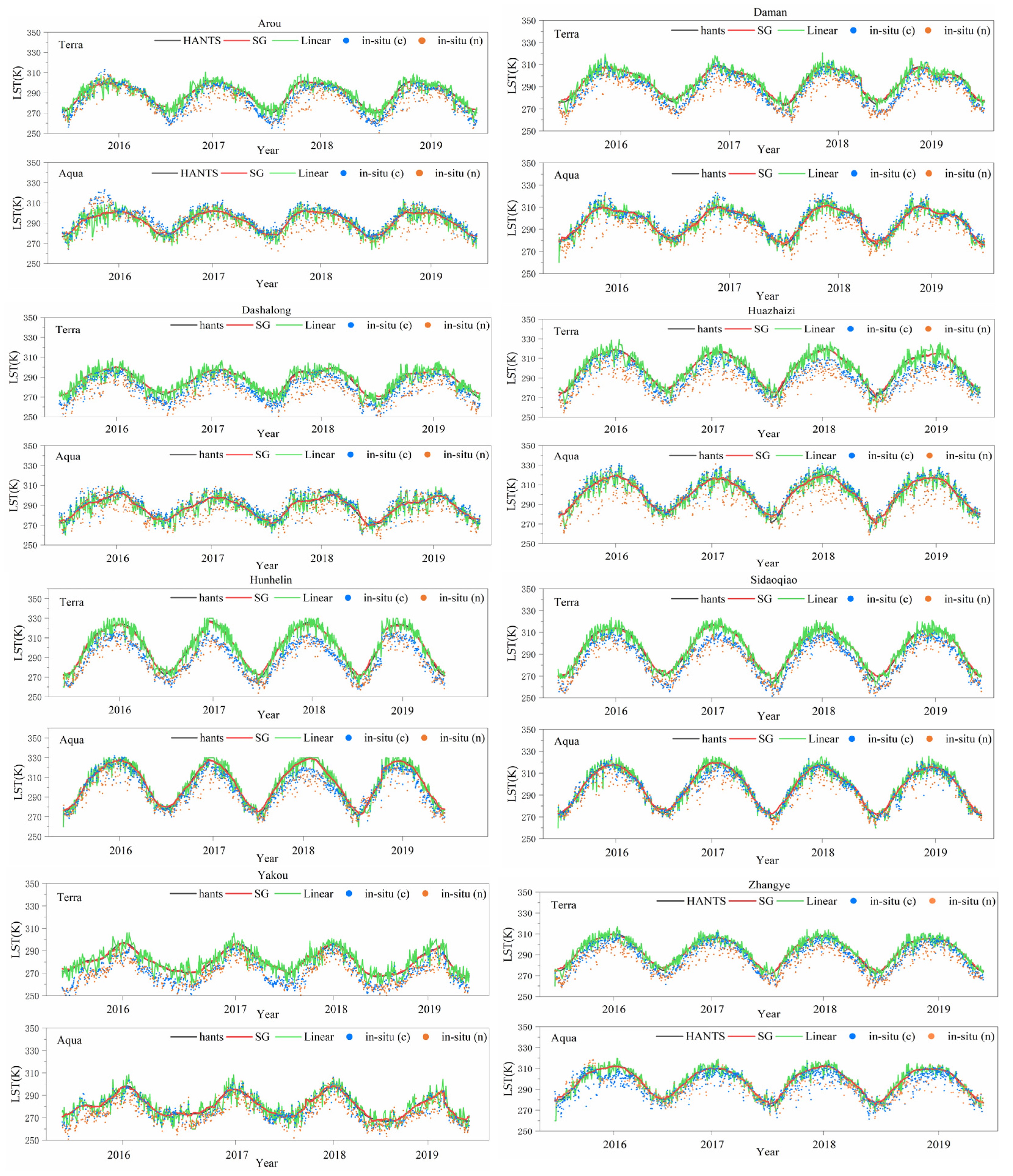
2.4.1. Temporal Method
2.4.2. Spatial Method
2.4.3. Spatiotemporal Method
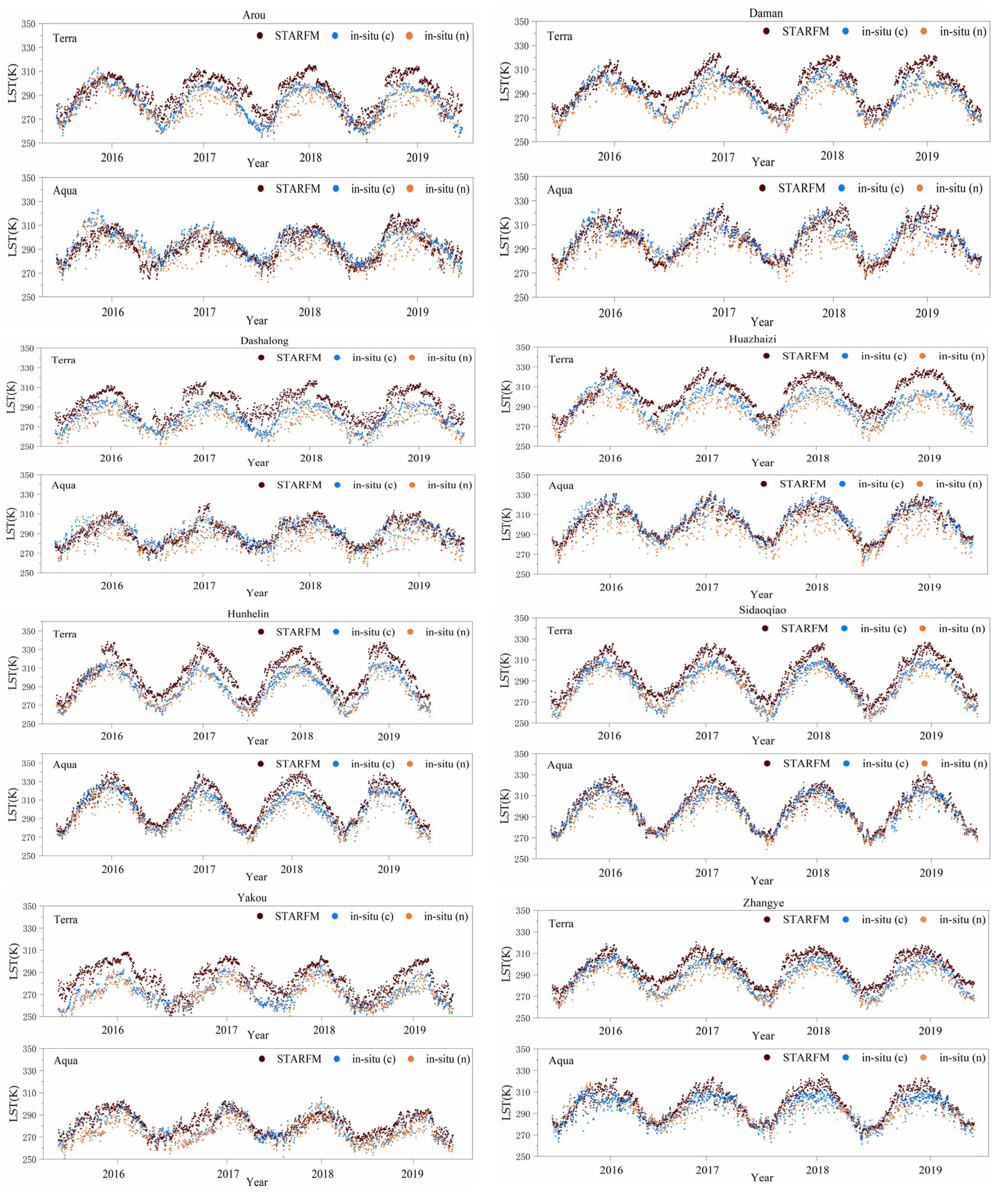
2.4.4. A Method Based on Classification and Adaptive Window
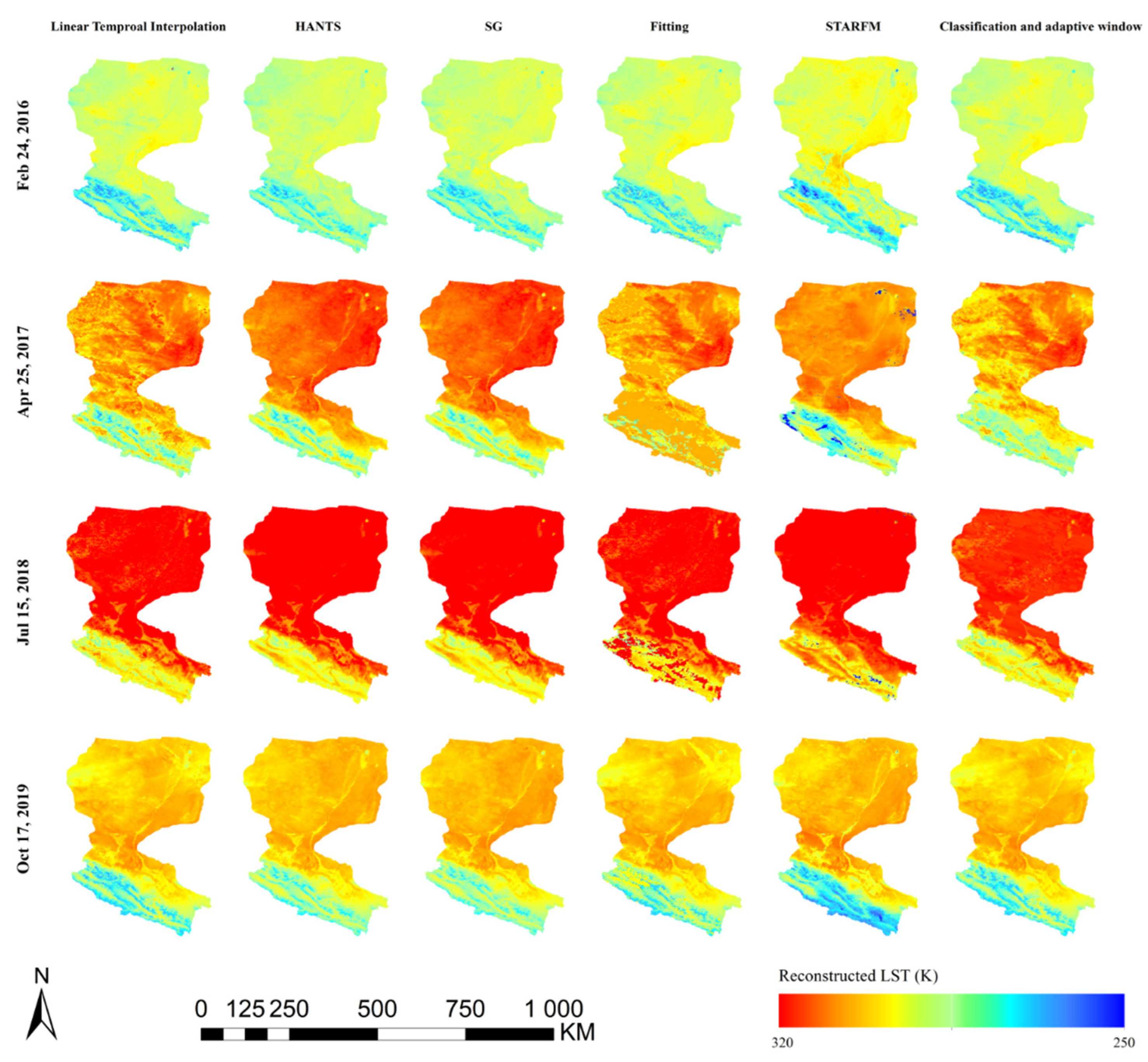
3. Results
3.1. Validation of the Temporal and Spatial Methods
3.2. Validation of the Spatiotemporal Method
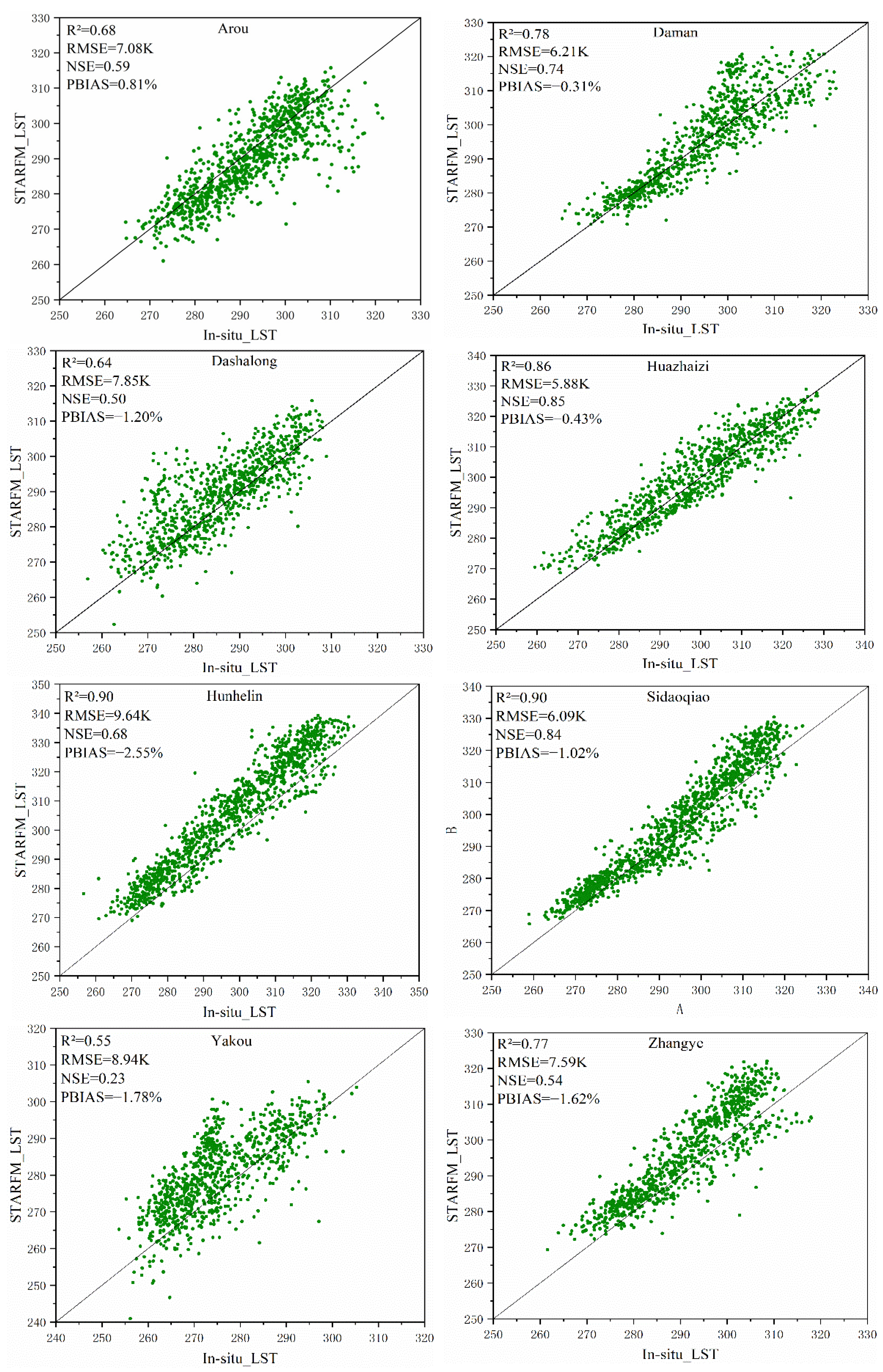
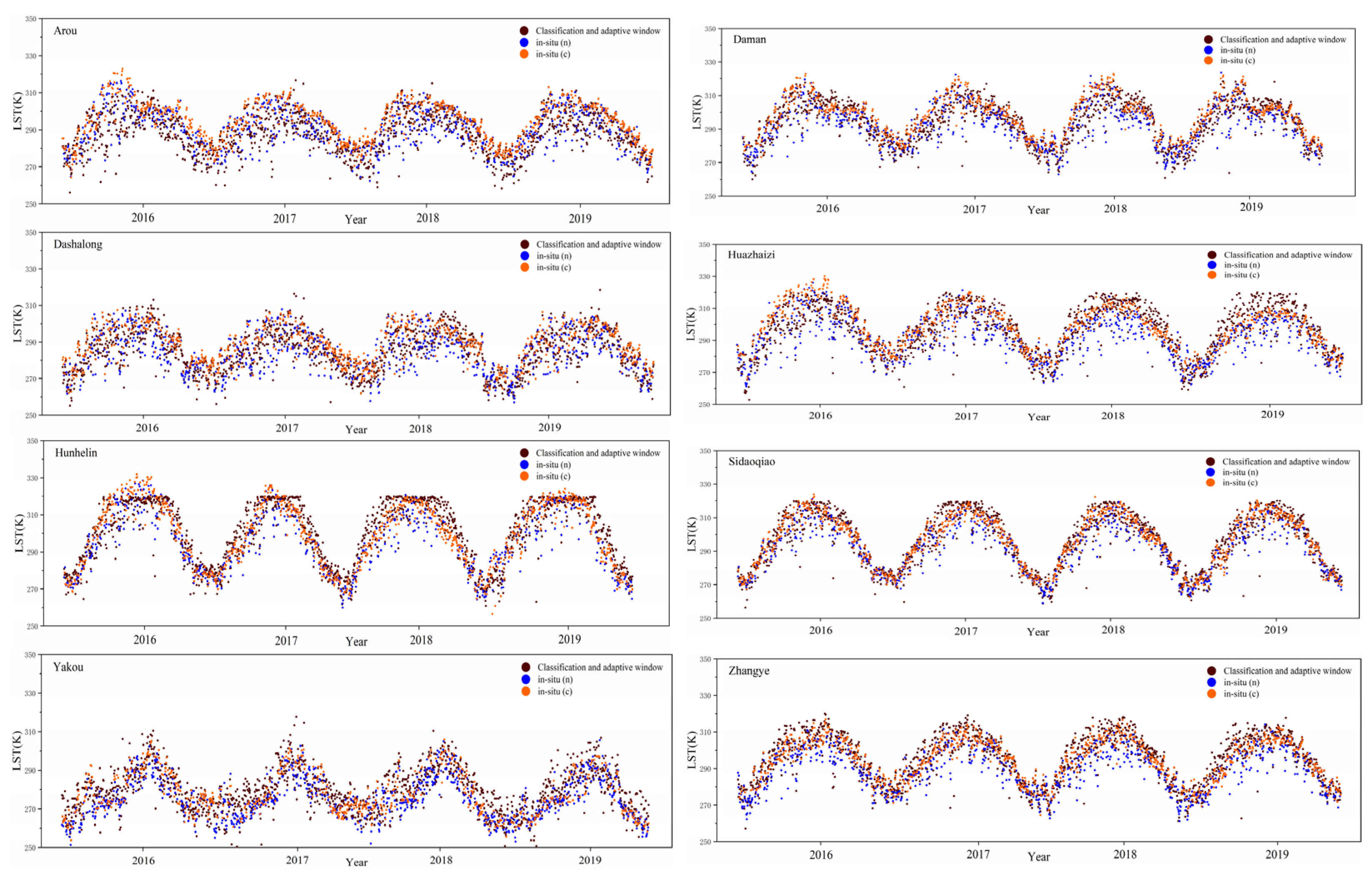
3.3. Validation of the CAAW Method
3.4. Analysis of LST Variation Characteristics Based on Soil Moisture
4. Discussion
5. Conclusions
Author Contributions
Funding
Institutional Review Board Statement
Informed Consent Statement
Data Availability Statement
Acknowledgments
Conflicts of Interest
References
- Anderson, M.C.; Norman, J.M.; Kustas, W.P.; Houborg, R.; Starks, P.J.; Agam, N. A thermal-based remote sensing technique for routine mapping of land-surface carbon, water and energy fluxes from field to regional scales. Remote Sens. Environ. 2008, 112, 4227–4241. [Google Scholar] [CrossRef]
- Kustas, W.; Anderson, M. Advances in thermal infrared remote sensing for land surface modeling. Agric. For. Meteorol. 2009, 149, 2071–2081. [Google Scholar] [CrossRef]
- Weng, Q. Thermal infrared remote sensing for urban climate and environmental studies: Methods, applications, and trends. ISPRS J. Photogramm. Remote Sens. 2009, 64, 335–344. [Google Scholar] [CrossRef]
- Mannstein, H. Surface Energy Budget, Surface Temperature and Thermal Inertia. In Remote Sensing Applications in Meteorology and Climatology; Springer: Doedrecht, The Netherlands, 1987; pp. 391–410. [Google Scholar]
- Sellers, P.J.; Hall, F.G.; Asrar, G.; Strebel, D.E.; Murphy, R.E. The first ISLSCP field experiment (FIFE). International Satellite Land Surface Climatology Project. Bull. Am. Meteorol. Soc. 1988, 69, 22–27. [Google Scholar] [CrossRef] [Green Version]
- Liang, S. An Optimization Algorithm for Separating Land Surface Temperature and Emissivity from Multispectral Thermal Infrared Imagery. IEEE Trans. Geosci. Remote 2001, 39, 274. [Google Scholar]
- Xue, Y.; Tong, Q.; Zhang, L. Progress in Hyperspectral Remote Sensing Science and Technology in China Over the Past Three Decades. J. Sel. Top. Appl. Earth Obs. Remote Sens. 2014, 7, 70–91. [Google Scholar]
- Alfieri, S.M.; Lorenzi, F.D.; Menenti, M. Mapping air temperature using time series analysis of LST: The SINTESI approach. Nonlinear Proc. Geoph. 2013, 20, 513–527. [Google Scholar] [CrossRef] [Green Version]
- Xu, Y.; Shen, Y.; Wu, Z. Spatial and Temporal Variations of Land Surface Temperature Over the Tibetan Plateau Based on Harmonic Analysis. Mt. Res. Dev. 2013, 33, 85–94. [Google Scholar] [CrossRef]
- Zeng, C.; Shen, H.; Zhong, M.; Zhang, L.; Wu, P. Reconstructing MODIS LST Based on Multitemporal Classification and Robust Regression. IEEE Geosci. Remote Sens. Lett. 2014, 12, 512–516. [Google Scholar] [CrossRef]
- Yu, W.; Ma, M.; Wang, X.; Tan, J. Estimating the land-surface temperature of pixels covered by clouds in MODIS products. J. Appl. Remote Sens. 2014, 8, 83525. [Google Scholar] [CrossRef]
- Metz, M.; Rocchini, D.; Neteler, M. Surface Temperatures at the Continental Scale: Tracking Changes with Remote Sensing at Unprecedented Detail. Remote Sens. 2014, 6, 3822–3840. [Google Scholar] [CrossRef] [Green Version]
- Jin, M. Interpolation of surface radiative temperature measured from polar orbiting satellites to a diurnal cycle: 2. Cloudy-pixel treatment. J. Geophys. Res. Atmos. 2000, 105, 4061–4076. [Google Scholar] [CrossRef]
- Stewart, S.B.; Nitschke, C.R. Improving temperature interpolation using modis lst and local topography: A comparison of methods in south east australia. Int. J. Climatol. 2016. [Google Scholar] [CrossRef]
- Fan, X.M.; Liu, H.G.; Liu, G.H.; Li, S.B. Reconstruction of MODIS land-surface temperature in a flat terrain and fragmented landscape. Int. J. Remote Sens. 2014, 35, 7857–7877. [Google Scholar] [CrossRef]
- Shwetha, H.R.; Kumar, D.N. Prediction of high spatio-temporal resolution land surface temperature under cloudy conditions using microwave vegetation index and ANN. ISPRS J. Photogramm. Remote Sens. 2016, 117, 40–55. [Google Scholar] [CrossRef]
- Pede, T.; Mountrakis, G. An empirical comparison of interpolation methods for MODIS 8-day land surface temperature composites across the conterminous Unites States. ISPRS J. Photogramm. Remote Sens. 2018, 142, 137–150. [Google Scholar] [CrossRef]
- Ke, L.; Song, C.; Ding, X. Reconstructing Complete MODIS LST Based on Temperature Gradients in Northeastern Qinghai-Tibet Plateau. In Proceedings of the Geoscience and Remote Sensing Symposium (IGARSS), 2012 IEEE International, Munich, Germany, 22–27 July 2012. [Google Scholar]
- Arroyo, M.P.; Villajos, S.O. Linear Temporal Interpolation Method in Etm+ Using Modis Data. 2016. Available online: https://www.rxiv.org/abs/1605.0189 (accessed on 1 October 2021).
- Zhang, G.L.; Xiao, X.M.; Dong, J.W.; Kou, W.L.; Jin, Q. Mapping paddy rice planting areas through time series analysis of MODIS land surface temperature and vegetation index data. ISPRS J. Photogramm. 2015, 106, 157–171. [Google Scholar] [CrossRef] [Green Version]
- Yan, J.; Shen, R.; Bao, Y.; Xinchuan, L.I. Research on the Reconstructing of MODIS LST Product of Jiangsu Province. Environ. Ence Technol. 2014, 37, 160–167. [Google Scholar]
- Maffei, C.; Alfieri, S.; Menenti, M. Characterising Fire Hazard from Temporal Sequences of Thermal Infrared MODIS Measurements. In Proceedings of the 1st EARSeL Workshop on Temporal Analysis of Satellite Images, Mykonos, Greece, 23–25 May 2012. [Google Scholar]
- Pigott, D.M.; Golding, N.; Mylne, A.; Zhi, H.; Hay, S.I. Mapping the zoonotic niche of Marburg virus disease in Africa. Trans. R. Soc. Trop. Med. Hyg. 2015, 109, 366–378. [Google Scholar] [CrossRef] [Green Version]
- Messina, J.P.; Pigott, D.M.; Nick, G.; Duda, K.A.; Brownstein, J.S.; Weiss, D.J.; Harry, G.; Robinson, T.P.; Marius, G.; William, W. The global distribution of Crimean-Congo hemorrhagic fever. Trans. R. Soc. Trop. Med. Hyg. 2015, 8, 503–513. [Google Scholar] [CrossRef]
- Mylne Adrian, Q.N.; Pigott, D.; Longbottom, M.; Joshua, S.; Freya, D.; Kirsten, A. Mapping the zoonotic niche of Lassa fever in Africa. Trans. R. Soc. Trop. Med. Hyg. 2015, 109, 483–492. [Google Scholar] [CrossRef] [PubMed] [Green Version]
- Mukherjee, S.; Joshi, P.K.; Garg, R.D. A comparison of different regression models for downscaling Landsat and MODIS land surface temperature images over heterogeneous landscape. Adv. Space Res. 2014, 54, 655–669. [Google Scholar] [CrossRef]
- Liu, S.M.; Xu, Z.W.; Wang, W.Z.; Jia, Z.Z.; Zhu, M.J.; Bai, J.; Wang, J.M. A comparison of eddy-covariance and large aperture scintillometer measurements with respect to the energy balance closure problem. Hydrol. Earth Syst. Sci. 2011, 15, 1291–1306. [Google Scholar] [CrossRef] [Green Version]
- Shaomin, L.; Li, X.; Xu, Z.; Che, T.; Ren, Z. The Heihe Integrated Observatory Network: A Basin-Scale Land Surface Processes Observatory in China. Vadose Zone J. 2018, 17, 1–12. [Google Scholar]
- Holmes, T.R.H.; De Jeu, R.A.M.; Dolman, J.A. Land surface temperature from Ka band (37 GHz) passive microwave observations. J. Geophys. Res. Atmos. 2009, 114. [Google Scholar] [CrossRef] [Green Version]
- Klingseisen, B.J. Spatio-Temporal Modelling of Bluetongue Virus Distribution in Northern Australia Based on Remotely Sensed Bioclimatic Variables. Ph.D. Thesis, Curtin University, Bentley, Australia, 2010. [Google Scholar]
- Roerink, G.J.; Menenti, M.; Verhoef, W. Reconstructing cloudfree NDVI composites using Fourier analysis of time series. Int. J. Remote Sens. 2000, 21, 1911–1917. [Google Scholar] [CrossRef]
- Gao, F.; Masek, J.; Schwaller, M.; Hall, F. On the blending of the landsat and MODIS surface reflectance: Predicting daily landsat surface reflectance. IEEE Trans. Geosci. Remote 2006, 44, 2207–2218. [Google Scholar]
- Cai, D.; Guo, N.; Chongwei, L.I. Interpolation of Air Temperature Based on DEM over Eastern Region of Gansu. J. Arid. Meteorol. 2009, 27, 10. [Google Scholar]
- Li, X.; Cheng, G.; Lu, L. Comparison Study of Spatial Interpolation Methods of Air Temperature over Qinghai-Xizang Plateau. Plateau Meteorol. 2003, 22, 565–573. [Google Scholar]
- Ke, L.; Wang, Z.; Song, C.; Lu, Z. Reconstruction of MODIS LST Time Series and Comparison with Land Surface Temperature (T) among Observation Stations in the Northeast Qinghai-Tibet Plateau. Prog. Geogr. 2011, 30, 819–826. [Google Scholar]
- Neteler, M. Estimating Daily Land Surface Temperatures in Mountainous Environments by Reconstructed MODIS LST Data. Remote Sens. 2010, 2, 333–351. [Google Scholar] [CrossRef] [Green Version]
- Hao, G.; Su, H.; Zhang, R.; Tian, J.; Chen, S. A Two-Source Normalized Soil Thermal Inertia Model for Estimating Field-Scale Soil Moisture from MODIS and ASTER Data. Remote Sens. 2022, 14, 1215. [Google Scholar] [CrossRef]
- Sun, H.; Zhou, B.; Liu, H. Spatial Evaluation of Soil Moisture (SM), Land Surface Temperature (LST), and LST-Derived SM Indexes Dynamics during SMAPVEX12. Sensors 2019, 19, 1247. [Google Scholar] [CrossRef] [PubMed] [Green Version]
- Wang, J.; Huang, B. A Rigorously-Weighted Spatiotemporal Fusion Model with Uncertainty Analysis. Remote Sens. 2017, 9, 990. [Google Scholar] [CrossRef] [Green Version]
- Stein, A.; Bastiaanssen, W.G.M.; De Bruin, S.; Cracknell, A.P.; Curran, P.J.; Fabbri, A.G.; Gorte, B.G.H.; Van Groenigen, J.W.; Van der Meer, F.D.; Saldana, A. Integrating spatial statistics and remote sensing. Int. J. Remote Sens. 1998, 19, 1793–1814. [Google Scholar] [CrossRef]
- Goovaerts, P. Geostatistics in soil science: State-of-the-art and perspectives. Geoderma 1999, 89, 1–45. [Google Scholar] [CrossRef]
- Holmes, T.R.H.; Hain, C.R.; Anderson, M.C. Cloud tolerance of remote-sensing technologies to measure land surface temperature. Hydrol. Earth Syst. Sci. 2016, 20, 3263–3275. [Google Scholar] [CrossRef] [Green Version]


| Station | Land Cover | Longitude (E) | Latitude (N) | Elevation (m) |
|---|---|---|---|---|
| Arou | Alpine meadow | 100.4643 | 38.0473 | 3033 |
| Daman | Cropland | 100.3722 | 38.8555 | 1556 |
| Dashalong | Swamp meadow | 98.9406 | 38.8399 | 3739 |
| Huazhaizi | Barren land | 100.3201 | 38.7659 | 1731 |
| Hunhelin | Populus Euphratica and Tamarix | 100.1335 | 41.9903 | 874 |
| Zhangye | Wetland | 100.4464 | 38.9751 | 1460 |
| Yakou | Alpine meadow | 100.2421 | 38.0142 | 4148 |
| Sidaoqiao | Tamarix | 101.1374 | 42.0012 | 873 |
| Satellite | Site | Statistics | Methods | |||
|---|---|---|---|---|---|---|
| Fitting (NDVI) | Linear Temporal Interpolation | HANTS | SG | |||
| Terra | Arou | R2 | 0.64 | 0.77 | 0.81 | 0.82 |
| RMSE | 12.71 | 9.27 | 9.01 | 9.00 | ||
| NSE | 0.02 | 0.48 | 0.51 | 0.51 | ||
| PBias | −3.39% | −2.45% | −2.46% | −2.44% | ||
| Daman | R2 | 0.88 | 0.89 | 0.88 | 0.88 | |
| RMSE | 10.05 | 8.49 | 8.88 | 9.12 | ||
| NSE | 0.41 | 0.58 | 0.53 | 0.50 | ||
| PBias | −0.36% | −2.56% | −2.67% | −2.27% | ||
| Dashalong | R2 | 0.62 | 0.79 | 0.76 | 0.76 | |
| RMSE | 13.74 | 10.74 | 11.27 | 11.35 | ||
| NSE | −0.53 | 0.06 | 0.01 | 0 | ||
| PBias | −4.21% | −3.43% | −3.55% | −3.58% | ||
| Huazhaizi | R2 | 0.82 | 0.84 | 0.81 | 0.80 | |
| RMSE | 12.00 | 12.35 | 13.16 | 13.17 | ||
| NSE | 0.23 | 0.19 | 0.06 | 0.06 | ||
| PBias | −3.44% | −3.71% | −3.96% | −4.01% | ||
| Hunhelin | R2 | 0.91 | 0.91 | 0.93 | 0.93 | |
| RMSE | 12.41 | 13.47 | 13.47 | 13.64 | ||
| NSE | 0.41 | 0.30 | 0.34 | 0.32 | ||
| PBias | −3.84% | −4.23% | −4.34% | −4.47% | ||
| Sidaoqiao | R2 | 0.91 | 0.94 | 0.94 | 0.93 | |
| RMSE | 11.51 | 10.26 | 10.37 | 10.62 | ||
| NSE | 0.48 | 0.41 | 0.58 | 0.56 | ||
| PBias | −3.65% | −3.30% | −3.35% | −3.43% | ||
| Yakou | R2 | 0.45 | 0.72 | 0.80 | 0.80 | |
| RMSE | 20.72 | 11.69 | 11.52 | 11.52 | ||
| NSE | −3.1 | −0.30 | −0.18 | −0.19 | ||
| PBias | −6.50% | −3.83% | −3.87% | −3.87% | ||
| Zhangye | R2 | 0.83 | 0.90 | 0.87 | 0.87 | |
| RMSE | 9.45 | 8.12 | 8.64 | 8.83 | ||
| NSE | 0.46 | 0.60 | 0.54 | 0.52 | ||
| PBias | −2.68% | −2.45% | −2.58% | −2.63% | ||
| Overall | R2 | 0.76 | 0.87 | 0.87 | 0.86 | |
| RMSE | 13.12 | 10.70 | 10.93 | 11.04 | ||
| NSE | 0.22 | 0.48 | 0.45 | 0.44 | ||
| PBias | −3.76% | −3.24% | −3.34% | −3.39% | ||
| Satellite | Site | Statistics | Methods | |||
|---|---|---|---|---|---|---|
| Fitting (NDVI) | Linear Temporal Interpolation | HANTS | SG | |||
| Aqua | Arou | R2 | 0.44 | 0.61 | 0.62 | 0.62 |
| RMSE | 10.38 | 7.21 | 6.84 | 6.85 | ||
| NSE | 0.12 | 0.58 | 0.62 | 0.62 | ||
| PBias | −0.79% | 0.39% | 0.30% | 0.27% | ||
| Daman | R2 | 0.66 | 0.78 | 0.69 | 0.68 | |
| RMSE | 8.28 | 6.1 | 7.16 | 7.22 | ||
| NSE | 0.56 | 0.76 | 0.66 | 0.65 | ||
| PBias | −0.67% | −0.38% | −0.64% | −0.66% | ||
| Dashalong | R2 | 0.46 | 0.71 | 0.52 | 0.52 | |
| RMSE | 9.66 | 6.45 | 7.92 | 7.95 | ||
| NSE | 0.33 | 0.70 | 0.52 | 0.52 | ||
| PBias | −0.87% | 0.21% | −0.34% | −0.37% | ||
| Huazhaizi | R2 | 0.72 | 0.79 | 0.67 | 0.66 | |
| RMSE | 8.61 | 7.36 | 9.20 | 9.21 | ||
| NSE | 0.71 | 0.79 | 0.66 | 0.66 | ||
| PBias | −0.21% | −0.18% | −0.54% | −0.58% | ||
| Hunhelin | R2 | 0.88 | 0.87 | 0.86 | 0.86 | |
| RMSE | 8.31 | 9.18 | 9.73 | 9.74 | ||
| NSE | 0.74 | 0.69 | 0.66 | 0.66 | ||
| PBias | −1.81% | −2.14% | −2.38% | −2.45% | ||
| Sidaoqiao | R2 | 0.86 | 0.90 | 0.88 | 0.87 | |
| RMSE | 7.05 | 5.90 | 6.44 | 6.46 | ||
| NSE | 0.78 | 0.85 | 0.82 | 0.82 | ||
| PBias | −1.29% | −1.00% | −1.13% | −1.19% | ||
| Yakou | R2 | 0.24 | 0.69 | 0.71 | 0.70 | |
| RMSE | 19.91 | 7.23 | 7.61 | 7.62 | ||
| NSE | -2.79 | 0.5 | 0.48 | 0.48 | ||
| PBias | −5.22% | −1.52% | −1.80% | −1.81% | ||
| Zhangye | R2 | 0.75 | 0.79 | 0.71 | 0.71 | |
| RMSE | 8.12 | 7.00 | 8.13 | 8.12 | ||
| NSE | 0.52 | 0.64 | 0.50 | 0.50 | ||
| PBias | −1.61% | −1.41% | −1.73% | −1.78% | ||
| Overall | R2 | 0.64 | 0.82 | 0.76 | 0.76 | |
| RMSE | 10.63 | 7.13 | 7.97 | 7.98 | ||
| NSE | 0.51 | 0.78 | 0.71 | 0.71 | ||
| PBias | −1.50% | −0.76% | −1.03% | −1.07% | ||
| Method | Satellite | Sites | |||||
|---|---|---|---|---|---|---|---|
| Statistics | Arou | Daman | Dashalong | Huazhaizi | |||
| STARFM (ERA5) | Terra | R2 | 0.68 | 0.79 | 0.12 | 0.74 | |
| RMSE | 12.24 | 11.52 | 48.38 | 16.2 | |||
| NSE | 0.08 | 0.2 | −17.19 | −0.43 | |||
| PBIAS | −3.33% | −3.33% | −2.56% | −4.91% | |||
| Sites | |||||||
| Statistics | Hunhelin | Sidaoqiao | Yakou | Zhangye | Overall | ||
| R2 | 0.9 | 0.93 | 0.71 | 0.87 | 0.4 | ||
| RMSE | 15.2 | 11.41 | 14.59 | 10.51 | 21.28 | ||
| NSE | 0.16 | 0.5 | −0.9 | 0.32 | −1.1 | ||
| PBIAS | −4.84% | −3.71% | −4.73% | −3.30% | −3.83% | ||
| Satellite | Sites | ||||||
| Statistics | Arou | Daman | Dashalong | Huazhaizi | |||
| Aqua | R2 | 0.53 | 0.74 | 0.55 | 0.8 | ||
| RMSE | 8.34 | 7.81 | 9.14 | 7.67 | |||
| NSE | 0.42 | 0.6 | 0.36 | 0.76 | |||
| PBIAS | −0.04% | −0.85% | −1.27% | −0.98% | |||
| Sites | |||||||
| Statistics | Hunhelin | Sidaoqiao | Yakou | Zhangye | Overall | ||
| R2 | 0.91 | 0.91 | 0.64 | 0.84 | 0.79 | ||
| RMSE | 10.37 | 6.34 | 8.83 | 7.74 | 8.34 | ||
| NSE | 0.61 | 0.82 | 0.3 | 0.55 | 0.68 | ||
| PBIAS | −2.95% | −1.28% | −2.14% | −1.83% | −1.40% | ||
| Site | Data | Statistics | |||
|---|---|---|---|---|---|
| R2 | RMSE | NSE | PBIAS | ||
| Arou | ERA5 | 0.57 | 8.54 | 0.39 | 1.35% |
| AMSR2 | 0.57 | 8.56 | 0.38 | 1.35% | |
| Daman | ERA5 | 0.80 | 5.75 | 0.78 | 0.28% |
| AMSR2 | 0.80 | 5.75 | 0.78 | 0.28% | |
| Dashalong | ERA5 | 0.58 | 7.69 | 0.51 | 0.30% |
| AMSR2 | 0.58 | 7.69 | 0.51 | 0.31% | |
| Huazhaizi | ERA5 | 0.76 | 7.40 | 0.70 | −0.53% |
| AMSR2 | 0.76 | 7.4 | 0.71 | −0.84% | |
| Hunhelin | ERA5 | 0.84 | 7.26 | 0.81 | −0.87% |
| AMSR2 | 0.84 | 7.24 | 0.81 | −0.86% | |
| Sidaoqiao | ERA5 | 0.89 | 5.35 | 0.88 | −0.37% |
| AMSR2 | 0.90 | 5.27 | 0.88 | −0.36% | |
| Yakou | ERA5 | 0.62 | 7.62 | 0.51 | −0.89% |
| AMSR2 | 0.62 | 7.57 | 0.51 | −0.88% | |
| Zhangye | ERA5 | 0.86 | 5.48 | 0.78 | −0.91% |
| AMSR2 | 0.86 | 5.47 | 0.78 | −0.91% | |
| Overall | ERA5 | 0.79 | 6.96 | 0.77 | −0.20% |
| AMSR2 | 0.79 | 6.95 | 0.77 | −0.20% | |
Publisher’s Note: MDPI stays neutral with regard to jurisdictional claims in published maps and institutional affiliations. |
© 2022 by the authors. Licensee MDPI, Basel, Switzerland. This article is an open access article distributed under the terms and conditions of the Creative Commons Attribution (CC BY) license (https://creativecommons.org/licenses/by/4.0/).
Share and Cite
Chen, D.; Zhuang, Q.; Zhu, L.; Zhang, W. Comparison of Methods for Reconstructing MODIS Land Surface Temperature under Cloudy Conditions. Appl. Sci. 2022, 12, 6068. https://doi.org/10.3390/app12126068
Chen D, Zhuang Q, Zhu L, Zhang W. Comparison of Methods for Reconstructing MODIS Land Surface Temperature under Cloudy Conditions. Applied Sciences. 2022; 12(12):6068. https://doi.org/10.3390/app12126068
Chicago/Turabian StyleChen, Dong, Qifeng Zhuang, Liang Zhu, and Wenjie Zhang. 2022. "Comparison of Methods for Reconstructing MODIS Land Surface Temperature under Cloudy Conditions" Applied Sciences 12, no. 12: 6068. https://doi.org/10.3390/app12126068
APA StyleChen, D., Zhuang, Q., Zhu, L., & Zhang, W. (2022). Comparison of Methods for Reconstructing MODIS Land Surface Temperature under Cloudy Conditions. Applied Sciences, 12(12), 6068. https://doi.org/10.3390/app12126068