Abstract
At 2:00 a.m. on 1 July 2020, after several days of continuous heavy rainfall, the Xinfangzi landslide occurred in Zhengping Village, Ganshui Town, Qijiang District, Chongqing City, China. The area of the landslide was about 3.85 × 10⁴ m2 and the volume was about 71.22 × 10⁴ m3. The Xinfangzi landslide can be defined as a push-type landslide. Specifically, the main sliding area pushed the front squeezing area, causing it to slide laterally. The entire slip path of the landslide was a broken line, while the right edge and the front shear outlet position slipped loosely in a circular arc. In this study, finite element numerical calculations were used to compare and analyze the multisection plastic deformation of the landslide under natural and rainfall conditions based on field investigations. The formation and failure characteristics of the Xinfangzi landslide were further revealed. The results show that the cross and longitudinal sections of the landslide were in a critical state of instability under natural and rainfall conditions. A compound section was established along the slip path based on the cross and longitudinal sections. Due to the extrusion of the trailing edge of the landslide, the compound section’s leading edge was in a state of instability under natural conditions. Under rainfall conditions, the increase in the unit weight of the sliding mass was superimposed on the compound section, which amplified the thrust of the trailing edge and further accelerated the overall sliding process of the landslide. Based on the macroscopic deformation of the landslide, it was found that the sliding of the trailing edge of the landslide is the key factor promoting the failure of the front edge, and local slump is possible under rainfall conditions.
1. Introduction
Mechanism analysis can reveal the development and evolution of landslides, which is the theoretical basis for predicting landslide disasters and performing effective prevention. However, due to the complexity of the geo-mechanical environment of landslides and the diversity of inducing factors, it is difficult to accurately obtain the evolution process of a landslide.
At present, a variety of methods have been developed to explore the failure mechanisms of landslides. Specifically, the various influential factors can be analyzed comprehensively by the engineering geological analogy method. In addition, the stability and development trend of landslides can be predicted quickly [1,2,3,4]. Considering the translational or rotational movement with an assumed or specific potential slip surface, the limit equilibrium analysis is used to investigate the instability of landslides under the influence of gravity [5,6]. After continuous revision and improvement, this method can determine the mechanical state of landslides effectively [7,8,9]. Based on the principle of similarity and field survey results, physical model experiments are also used to predict or reproduce the evolution of landslides [10,11,12].
The numerical simulation can obtain the stress or strain distribution and analyze the dynamic failure. When performing numerical calculations, the finite element method (FEM) [13,14,15,16,17], discrete element method (DEM) [18,19], material point method (MPM) [20,21,22], and the smoothed particle method (SPM) [23] are commonly used. Notably, it is important to determine the geological model, mechanical model, and mechanical parameters during the numerical simulation. In addition, these settings are the key factors to ensure the simulation results’ reliability and validity [24,25]. Since there are many factors affecting the stability of landslide, mathematical methods are adapted to determine the stability quantitatively or semi-quantitatively, such as dissipation theory [26,27], chaos theory [28], stochastic theory [29], fuzzy theory [30], gray system theory [31], catastrophe theory [32], and so on. Furthermore, combining field investigations and numerical simulations is still an effective and fast method of analyzing the evolution process of a landslide, and it can be promoted in the actual application process.
At around 2:00 a.m. on 1 July 2020, after several days of continuous heavy rainfall, the Xinfangzi landslide (106°44′59.88′′ E, 28°43′13.50′′ N; Figure 1) occurred in Zhengping Village, Ganshui Town, Qijiang District, Chongqing City, China. Based on on-site investigations, FEM was used to analyze the formation and failure characteristics of the Xinfangzi landslide and the related inducing factors. The plastic deformation of multiple sections under natural and rainfall conditions were compared to further reveal the catastrophic mechanism of the Xinfangzi landslide.
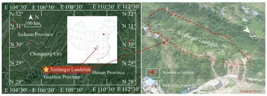
Figure 1.
The location of the Xinfangzi landslide.
2. Study Area
The Xinfangzi landslide is located in a low mountain gorge formed by the Songkan River. The topography of the study area is high in the southeast and low in the northwest, exhibiting a trend of gradual collapse along the slope direction (Figure 1).
The west side of the study area is a rocky cliff. The east side of the study area is a steep slope, and the foot of the slope is the Songkan River and the G210 National Highway. The highest point in the study area is located at the top of the steep wall on the trailing edge, with an elevation of 438.50 m. The lowest point is located at the shear outlet of the front edge (330.00 m). The overall height difference of the landslide is 108.50 m.
The trailing boundary of the landslide is a tension-cracked slot; the left boundary is a continuously falling steep ridge; and the right boundary is a newly constructed rural road. The shear outlet of the leading edge is bounded by an extrusion slump zone on the middle and upper part of the steep slope. The landslide is about 550 m long and 80.5–106.3 m wide, with an area of 3.85 × 10⁴ m2, a thickness of 4.1–33.6 m, an average thickness of 18.5 m, and a volume of about 71.22 × 10⁴ m3.
The main sliding direction of the middle and rear parts of the landslide is about 342°. Blocked by the northern mountains, the front edge of the landslide was sheared by lateral extrusion along the direction of 13°.
3. Deformation History of the Xinfangzi Landslide
According to the on-site investigations, the deformation history of the Xinfangzi landslide can be divided into three stages.
The first stage of deformation. A large number of cracked rocks identified as landslide residues are distributed in the study area, with a large thickness. These collapsed Quaternary deposits are located on the top of the fractured rock and the cracked slot formed by the ancient landslide. This indicates that the landslide has experienced many large-scale sliding events since the Holocene, and the Xinfangzi landslide occurred on the basis of the reactivation of the ancient landslide.
The second stage of deformation. During the flood season in 1988, large-scale overall slip occurred in the study area. The left side of the landslide slide about 1.5–3.5 m downward (the same position as the new Xinfangzi landslide; Figure 2). A sliding mass of about 5000 m3 was pushed out at the shear outlet of the landslide, damaging five residential houses on the slope and blocking the G210 national road.
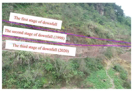
Figure 2.
Side edge ridges formed by multiple downward sliding events of the landslide.
The third stage of deformation. After several days of continuous heavy rainfall (Figure 3), the trailing edge of the landslide began slow creep deformation on 28 June 2020. At about 2:00 a.m. on 1 July 2020, the landslide slipped as a whole. A sliding mass of about 2000 m3 at the front edge blocked the G210 national road. At the same time, the loosening and deformation of the right boundary of the landslide damaged one house.
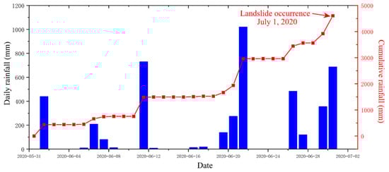
Figure 3.
Cumulative rainfall prior to the occurrence of the Xinfangzi landslide.
4. Deformation Distribution and Composition of the Landslide
According to the existing deformation of the landslide and the development characteristics of the surface cracks, the landslide can be divided into three areas: the main sliding area in the rear-central slip progressive area, the right loosely deformed area, and the front extrusion slump area (Figure 4).
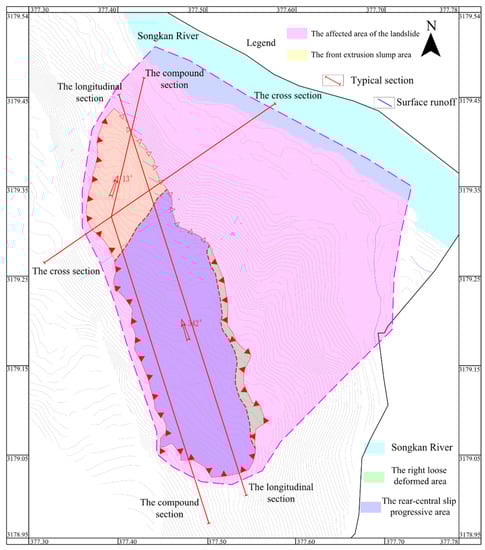
Figure 4.
The section layout of the Xinfangzi landslide.
The main sliding area in the rear-central slip progressive area (Area I). The sliding direction of the rear-central area was 342°, which drove the overall sliding of the landslide. Area I is longitudinal, and is about 302 m long and 104 m wide. It has an area of about 3.14 × 10⁴ m2, a thickness of 4.1–33.6 m, an average thickness of 19.54 m, and a volume of about 61.37 × 10⁴ m3. The sliding mass of Area I is mainly composed of ancient landslide debris and later accumulated rocks caused by the collapse. The length of the rear tension crack slot in this area is about 11–16.5 m, the width is about 1.5–3.5 m, and the visible depth is about 1.6–3.9 m. The left boundary of Area I moved downward by about 2.3 to 7.8 m as a whole, and the length of the falling ridge is about 450 m. In addition, the soil of the shear outlet at the right front side is loaded on the slope, causing a local slump.
The right loosely deformed area (Area II). Area II is a long strip with a length of about 240 m and a width of about 3–12 m. It slid in the direction of 45–60° under the control of steep local ridges (rural road slopes). A total of five small landslides were formed in this area, with volumes of about 5 to 400 m3, covering the roadbed.
The front extrusion slump area (Area III). Area III slid in the direction of 13° under the push of Area I. This area is fan-shaped, with a length of about 113 m, a width of about 84 m, an area of about 0.95 × 10⁴ m2, a thickness of 7.8–25.5 m, an average thickness of 16.3 m, and a volume of about 15.47 × 10⁴ m3. The deformation of this area was mainly the formation of a penetrating step, with a height of about 0.5 to 2.6 m, on the left backside under push. Plume cracks were formed by squeezing and shearing. Part of the soil in this area collapsed from the front edge of the shear outlet to the G210 national road.
According to the drilling results (Figure 5), the thickness of the sliding mass is about 4.1–33.6 m, with an average thickness of 18.5 m. The sliding mass at the trailing edge is mainly mudstone intercalated with sandstone residues after slippage disintegration, with a thickness of about 2.7 to 31.8 m. The sliding mass in the middle and front part is mainly composed of silty clay and stone soils, with a thickness of about 23.4 m.
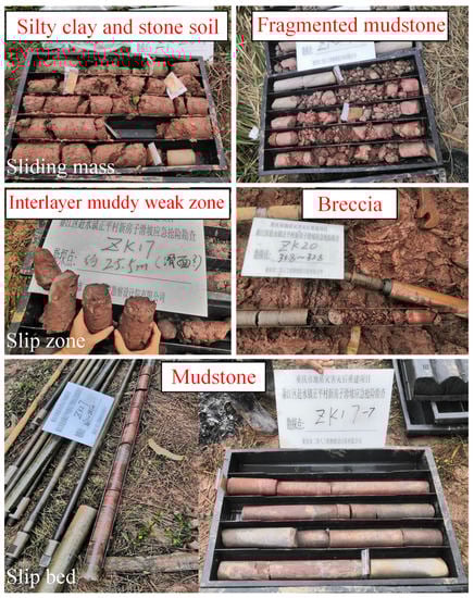
Figure 5.
The components of the Xinfangzi landslide.
The slip zone in the rear of the fragmented rock is a soft and muddy interlayer between the layers. The drilling results indicate that this part of the slip zone exhibits slip and tension in a 1.50 m area, and obvious scratches were observed. The slip zone in the middle-front part of the soil is the breccia of the rock-soil interface, which has a dense structure and obvious extrusion characteristics.
The slip bed is the bedrock of the interbedded mudstone and sandstone of the Middle Jurassic Shaximiao Formation, with a burial depth of about 4.10–33.6 m. The front and right edges are shallower, and the rear and left edges are deeper.
The groundwater in the study area distributes in loose rock pore, landslide rock debris fissure, and bedrock fissure. The water in the boreholes was drained to observe the dynamics of the water level. After 24 h, the groundwater level at the rear part was 0.20–11.50 m, and that in the middle-front part was 0.2–16.65 m. In addition, the water level in the borehole increased significantly after rainfall. Notably, the groundwater levels in the boreholes were quite different, indicating that there is no stable groundwater level for the entire landslide. This phenomenon is related to the local stagnant water and surface runoff caused by the rainfall (Figure 6).
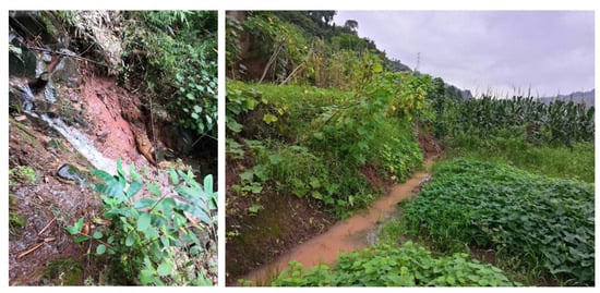
Figure 6.
Surface water on the landslide area (8 July 2020).
5. Factors Influencing Landslide Stability
After the occurrence of the Xinfangzi landslide, the current factors affecting its stability involve the following five aspects.
Topography. The slopes of the study area tend to be north (342°) and east (55°). The height difference between the northern and southern parts of the landslide is about 80.2–88.50 m, and the difference between the eastern and western parts is about 35.4–48.3 m. The height difference between the front and rear edges of the landslide is large, and the northeast side of the landslide is a steep slope with an average slope angle of 65° that is undercut by the Songkan River. This topography provides space for sliding.
Stratum lithology. The middle and upper parts of the sliding mass are composed of silty clay intercalated with crushed stones and rocky soil. The lower part of the sliding mass is composed of landslide debris and fragmented rocks, in which cracks are developed, leading to good water retention. The slip bed is a relatively complete mudstone and acts as a water barrier. Rainfall infiltration causes the landslide soil to become saturated and infiltrated for a long time, and the soil layer easily slips along the sliding surface of the ancient landslide.
Groundwater. During the dry season, springs leak from the right boundary of the landslide and the front edge of the shear outlet. According to the drilling results, the soil in the middle and lower parts of the sliding mass is saturated. The groundwater level in the sliding mass is relatively high, and runoff and drainage channels are developed. The groundwater mainly flows northward along the sliding surface from the middle and rear parts of the landslide, and it is discharged at the front of the landslide. A high fissure water pressure and sliding surface uplift pressure are formed by the groundwater stored in the unloading and expanding fissures in the middle and rear parts of the landslide. Due to the runoff and the seepage of the groundwater, the sliding mass will become saturated and softened for a long time, the fine-grained material will be eroded, and the shear strength of the sliding surface will continue to decrease, forming a potential weak sliding zone. These are the main factors leading to the instability of the Xinfangzi landslide.
Heavy rainfall. According to the field surveys, the water catchment area at the cliff on the west side of the landslide is large, and this area contains stepped terraces with developed lateral drainage systems. This causes a large amount of the catchment water to flow back into the landslide along the cliff fissures. The middle and upper parts of the landslide are mainly composed of silty clay mixed with crushed stone and rocky soil, which is conducive to accelerating rainfall infiltration to form groundwater. In addition, based on the deformation history of the landslide, the two large-scale slips that occurred in 1998 and 2020 were both induced by heavy rainfall during the flood season. Therefore, it is concluded that heavy rainfall is the main factor affecting the instability of the landslide.
Human engineering activities. Long-term farming has resulted in the better water permeability of the soil. These human activities contribute to the infiltration of surface water into the landslide. Due to the construction of rural roads, a slope with a height of about 3 to 4 m has been formed on the front and left sides of the landslide, providing space for local deformation of the landslide.
6. Plastic Deformation Analysis of Multiple Sections
Since the boreholes are laid along with the typical profiles, the 2D numerical models have the most detailed geological data, involving the position and the mechanical parameters of the sliding zone. Compared to the numerical models in 3D, the 2D simulation results can be identified as the closest analysis to the actual condition and easier to reveal the failure mechanism of landslides with complex slip paths. Therefore, the numerical simulations in 2D were carried out on multiple typical sections of the landslide using the strength reduction method [33,34], and the plastic deformation trends of the landslide under different conditions were compared. Specifically, the factor of safety (FOS) can be obtained through the c-φ reduction algorithm by the FEM [35,36,37,38]. In addition, the numerical non-convergence occurs simultaneously when the system reaches instability. The FOS and plastic strain distribution are then obtained [39,40].
The typical sections involved three types: a cross section, a longitudinal section, and a compound section (Figure 4 and Figure 7). The multiple sections of the landslide were simplified into geo-mechanical models covering the sliding mass, slip zone, and slip bed. In addition, the distribution of the groundwater inside the landslide was considered. According to on-site investigations, after heavy rainfall, the surface soil of the landslide is almost fully saturated, and water flows out on the slope’s surface. Therefore, the mechanical state of the landslide was simplified under rainfall conditions, and the sliding mass and the slip zone above the groundwater level were converted into saturation parameters. The impact of heavy rainfall on the landslide will be further analyzed in the discussion part of this paper. Notably, the unsaturated mechanical states were ignored. In this way, the simplification under the rainfall conditions can be better transferred, and the failure mechanism of the landslide with the complicated slip path can be highlighted.
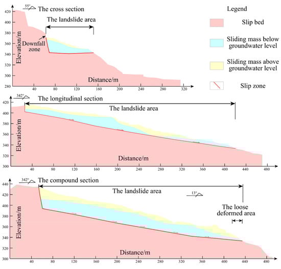
Figure 7.
The computational model for multiple sections.
The MIDAS GTS numerical calculation software was used in this study. The Mohr-Coulomb model was selected to characterize the mechanical properties of the landslide. The unit weights and shear strength parameters were obtained from laboratory tests, and the elastic modulus and Poisson’s ratio were adapted from the relevant literature [41,42]. All relevant calculation parameters are shown in Table 1. The other parameters, such as the dilatancy angle of the soil, are not considered here.

Table 1.
Numerical calculation parameters.
By analyzing the plastic strain distribution of each section under natural conditions (Figure 8; Table 2), it was found that the plastic strain of the cross section is the largest, and the strain is concentrated at the front edge of the sliding zone. The plastic deformation area of the longitudinal section is concentrated in the middle and lower parts of the section, and the plastic deformation of the slip zone does not penetrate. The comparison indicates that the cross and longitudinal sections of the landslide are both in a critical state of instability under natural conditions.
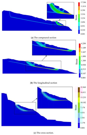
Figure 8.
The plastic strain distribution in multiple sections under natural conditions.
Table 2.
Characteristic parameters of the typical landslide section.
Based on this, the compound section of the landslide was analyzed. The plastic zone of the compound section is still not penetrated in the slip zone. Due to the extrusion of the trailing edge of the landslide, the leading edge is in an unstable state (the FOS is less than 1). It should be noted that the compound section of the landslide was established along the slip path based on the cross and longitudinal sections. Under the actual condition, the extrusion caused by the slip of the trailing edge does not directly act on the leading edge of the landslide. Thus, the superimposed compound section amplifies the thrust of the trailing edge, which further reduces the stability of the leading edge.
It can be concluded that the landslide under natural conditions is basically stable as a whole. The possibility of local collapse exists at the leading edge of the landslide, and the sliding of the trailing edge could promote the failure of the leading edge. After the leading edge slips, the overall instability of the landslide may be further induced.
7. Discussion
To explore the impact of short-term heavy rainfall on the Xinfangzi landslide, a further comparative study was performed on the plastic strain distributions in multiple sections under rainfall conditions (Figure 9; Table 2).

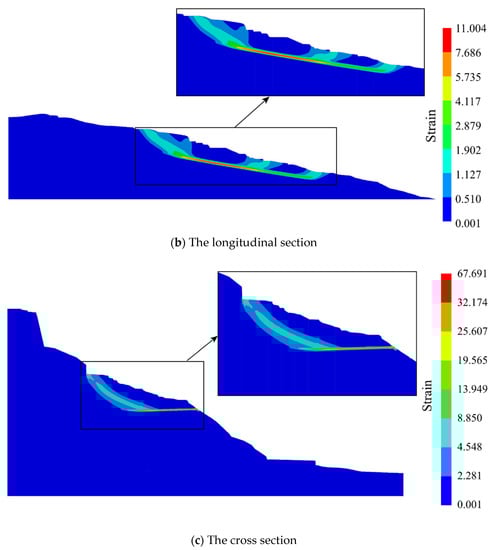
Figure 9.
The plastic strain distributions in multiple sections under rainfall conditions.
The analysis shows that the distributions of the plastic deformation of the landslide under natural and rainfall conditions are basically similar, but to a certain extent, the maximum plastic strain value under rainfall conditions is higher. Specifically, the maximum plastic strain of the compound section has the smallest increase due to rainfall, while the maximum plastic strains in the cross and longitudinal sections under rainfall conditions are about twice those under natural conditions.
The comparison of the FOS under different conditions shows that the cross and longitudinal sections are still basically stable under rainfall conditions. This is caused by the location of the groundwater level in the landslide area. Under natural conditions, the sliding zone, which controls the overall slippage of the landslide, is already below the groundwater level. Under rainfall conditions, the overlying part of the sliding mass becomes saturated. Due to its unit weights increase slightly, the rainfall has little effect on advancing the shear failure of the cross and longitudinal sections.
However, under rainfall conditions, the FOS decreases more in the compound section than in the cross and longitudinal sections. The increase in the unit weight of the sliding mass amplifies the thrust of the trailing edge in the composite superimposed section, which further accelerates the overall sliding of the landslide. Therefore, heavy rainfall may promote local sliding at the leading edge of the landslide and may cause a new landslide to move downward as a whole, just like the previous three large-scale deformations (Figure 2). After many rainy seasons, the local collapse of the leading edge and the progressive penetration of the plastic deformation of the slip zone will continue to promote the overall slippage of the landslide.
8. Conclusions
According to the on-site investigation, the sliding process of the Xinfangzi landslide is as follows: under the action of a high fracture water pressure and sliding surface water pressure, the fragmented rock mass in the middle and rear parts of the ancient landslide slipped along the soft silt of the interbedded layer (the original sliding surface) on the north side. The squeezed front soil was blocked by the stable mountain in the northern section, and the sliding mass slipped to the northeast as a whole.
To further reveal the formation and failure mechanism of the Xinfangzi landslide, the plastic strain was analyzed in multiple sections under different conditions through FEM. The results show that the cross and longitudinal sections of the landslide are in a critical state of instability under natural and rainfall conditions. Due to the extrusion of the trailing edge of the landslide, the leading edge of the compound section is already in an unstable state under natural conditions. Under rainfall conditions, the increase in the unit weight of the sliding mass is superimposed on the compound section, which amplifies the thrust of the trailing edge and further promotes the overall sliding of the landslide.
Based on on-site surveys and numerical calculations, it was found that the sliding of the trailing edge of the Xinfangzi landslide could promote the failure of the leading edge. After many rainy seasons, the local collapse of the leading edge and the progressive penetration of the plastic deformation of the slip zone will increase the possibility of the overall slippage of the landslide. The related research methods provide an important reference for analyzing the formation and failure mechanism of landslides with complex slip paths.
Author Contributions
Methodology, L.W.; software, K.Z.; investigation, H.Z.; resources, Z.Z.; supervision, W.Z. All authors have read and agreed to the published version of the manuscript.
Funding
This research was funded by National Key R&D Program of China (Project No. 2019YFC1509605) and Natural Science Foundation of Chongqing, China (cstc2021jcyj-bsh0047).
Informed Consent Statement
Not applicable.
Data Availability Statement
Not applicable.
Conflicts of Interest
The authors declare no conflict of interest.
References
- Kilburn, C.R.J.; Petley, D.N. Forecasting giant, catastrophic slope collapse: Lessons from Vajont, Northern Italy. Geomorphology 2003, 54, 21–32. [Google Scholar] [CrossRef]
- Sun, S.R.; Xu, P.L.; Wu, J.M.; Wei, J.H.; Fu, W.G.; Liu, J.; Debi, P.K. Strength parameter identification and application of soil-rock mixture for steep-walled talus slopes in southwestern China. Bull. Eng. Geol. Environ. 2014, 73, 123–140. [Google Scholar]
- Gao, W. Stability analysis of rock slope based on an abstraction ant colony clustering algorithm. Environ. Earth Sci. 2015, 73, 7969–7982. [Google Scholar] [CrossRef]
- Wang, L.Q.; Yin, Y.P.; Huang, B.L.; Zhang, Z.H.; Wei, Y.J. Formation and characteristics of Guang’an Village landslide in Wuxi, Chongqing, China. Landslides 2019, 16, 127–138. [Google Scholar] [CrossRef]
- Zhu, D.Y.; Lee, C.F.; Jiang, H.D. Generalized framework of limit equilibrium methods for slope stability analysis. Géotechnique 2003, 53, 377–395. [Google Scholar] [CrossRef]
- Asadollahi, P.; Tonon, F. Limiting equilibrium versus BS3D analysis of a tetrahedral rock block. Int. J. Numer. Anal. Met. Geomech. 2012, 36, 50–61. [Google Scholar] [CrossRef]
- Nilsen, B. Rock slope stability analysis according to Eurocode 7, discussion of some dilemmas with particular focus on limit equilibrium analysis. Bull. Eng. Geol. Environ. 2017, 76, 1229–1236. [Google Scholar] [CrossRef]
- Cui, Y.; Bao, P.; Xu, C.; Fu, G.; Jiao, Q.; Luo, Y.; Shen, L.; Xu, X.; Liu, F.; Lyu, Y.; et al. A big landslide on the Jinsha River, Tibet, China: Geometric characteristics, causes, and future stability. Nat. Hazards 2020, 104, 2051–2070. [Google Scholar] [CrossRef]
- Wu, K.; Chen, N.; Hu, G.; Han, Z.; Ni, H.; Rahman, M. Failure mechanism of the Yaoba loess landslide on March 5, 2020: The early-spring dry spell in Southwest China. Landslides 2021, 18, 3183–3195. [Google Scholar] [CrossRef]
- Fahey, M.; Finie, I.; Hensley, P.J.; Jewell, R.J.; Randolph, M.F.; Stewart, D.P.; Stone, K.J.L.; Toh, S.H.; Windsor, C.S. Geotechnical Centrifuge Modelling at the University of Western Austrialia; Department of Civil Engineering, The University of Western Australia: Perth, WA, Australia, 1990. [Google Scholar]
- Adhikapy, D.P.; Dyskin, A.V. Modelling of progressive and instantaneous failure of foliated rock slopes. Rock Mech. Rock Eng. 2007, 40, 349–362. [Google Scholar] [CrossRef]
- Liu, H.-D.; Li, D.-D.; Wang, Z.-F.; Geng, Z.; Li, L.-D. Physical modeling on failure mechanism of locked-segment landslides triggered by heavy precipitation. Landslides 2019, 17, 459–469. [Google Scholar] [CrossRef]
- Clough, R.W.; Woodward, R.J. Analysis of embankment stresses and deformations. J. Soil Mech. Found. Div. 1967, 93, 529–549. [Google Scholar] [CrossRef]
- Potts, D.M.; Dounias, G.T.; Vaughan, P.R. Finite element analysis of progressive failure of Carsington embankment. Géotechnique 1990, 40, 79–101. [Google Scholar] [CrossRef]
- Griffiths, D.V.; Lane, P.A. Slope stability analysis by finite elements. Géotechnique 1999, 49, 387–403. [Google Scholar] [CrossRef]
- Bendezu, M.; Romanel, C.; Roehl, D. Finite element analysis of blast-induced fracture propagation in hard rocks. Comput. Struct. 2017, 182, 1–13. [Google Scholar] [CrossRef]
- Wang, L.; Yin, Y.; Huang, B.; Zhang, Z.; Zhao, P.; Wei, Y. A study of the treatment of a dangerous thick submerged rock mass in the three gorges reservoir area. Bull. Int. Assoc. Eng. Geol. 2020, 79, 2579–2590. [Google Scholar] [CrossRef]
- Wang, L.; Huang, B.; Zhang, Z.; Dai, Z.; Zhao, P.; Hu, M. The analysis of slippage failure of the HuangNanBei slope under dry-wet cycles in the three gorges reservoir region, China. Geomat. Nat. Hazards Risk 2020, 11, 1233–1249. [Google Scholar] [CrossRef]
- Zhang, S.L.; Yin, Y.P.; Hu, X.W.; Wang, W.P.; Zhang, N.; Zhu, S.N.; Wang, L.Q. Dynamics and emplacement mechanisms of the successive Baige landslides on the Upper Reaches of the Jinsha River, China. Eng. Geol. 2020, 278, 105819. [Google Scholar] [CrossRef]
- Yerro, A.; Soga, K.; Bray, J. Runout evaluation of Oso landslide with the material point method. Can. Geotech. J. 2019, 56, 1304–1317. [Google Scholar] [CrossRef] [Green Version]
- Conte, E.; Pugliese, L.; Troncone, A. Post-failure analysis of the Maierato landslide using the material point method. Eng. Geol. 2020, 277, 105788. [Google Scholar] [CrossRef]
- Troncone, A.; Pugliese, L.; Conte, E. Run-Out Simulation of a Landslide Triggered by an Increase in the Groundwater Level Using the Material Point Method. Water 2020, 12, 2817. [Google Scholar] [CrossRef]
- Braun, A.; Cuomo, S.; Petrosino, S.; Wang, X.; Zhang, L. Numerical SPH analysis of debris flow run-out and related river damming scenarios for a local case study in SW China. Landslides 2017, 15, 535–550. [Google Scholar] [CrossRef]
- Scaringi, G.; Fan, X.; Xu, Q.; Liu, C.; Ouyang, C.; Domènech, G.; Yang, F.; Dai, L. Some considerations on the use of numerical methods to simulate past landslides and possible new failures: The case of the recent Xinmo landslide (Sichuan, China). Landslides 2018, 15, 1359–1375. [Google Scholar] [CrossRef]
- Sarfaraz, H.; Amini, M. Numerical Modeling of Rock Slopes with a Potential of Block-Flexural Toppling Failure. J. Min. Environ. 2020, 11, 247–259. [Google Scholar]
- Qin, Z.C.; Li, T.; Li, Q.H.; Chen, G.B.; Cao, B. Mechanism of Rock Burst Based on Energy Dissipation Theory and Its Applications in Erosion Zone. Acta Geodyn. Geromater. 2019, 16, 119–130. [Google Scholar]
- Wang, L.; Wu, C.; Gu, X.; Liu, H.; Mei, G.; Zhang, W. Probabilistic stability analysis of earth dam slope under transient seepage using multivariate adaptive regression splines. Bull. Int. Assoc. Eng. Geol. 2020, 79, 2763–2775. [Google Scholar] [CrossRef]
- Gao, X.J. Bifurcation Behaviors of the two-state variable friction law of a rock mass system. Int. J. Bifurc. Chaos 2013, 23, 1350184. [Google Scholar]
- Mitchell, A.; Hungr, O. Theory and calibration of the Pierre 2 stochastic rock fall dynamics simulation program. Can. Geotech. J. 2017, 54, 18–30. [Google Scholar] [CrossRef]
- Daftaribesheli, A.; Ataei, M.; Sereshki, F. Assessment of rock slope stability using the Fuzzy Slope Mass Rating (FSMR) system. Appl. Soft Comput. 2011, 11, 4465–4473. [Google Scholar] [CrossRef]
- Liu, D.X.; Cao, P. Preliminary study of improved SMR method based on gray system theory. Rock Soil Mech. 2015, 36, 408–412. [Google Scholar]
- Wang, L.Q.; Yin, Y.P.; Huang, B.L.; Dai, Z.W. Damage evolution and stability analysis of the Jianchuandong Dangerous Rock Mass in the Three Gorges Reservoir Area. Eng. Geol. 2020, 265, 105439. [Google Scholar] [CrossRef]
- Dawson, E.M.; Roth, W.H.; Drescher, A. Slope stability analysis by strength reduction. Géotechnique 1999, 49, 835–840. [Google Scholar] [CrossRef]
- Meng, Q.-X.; Wang, H.; Xu, W.; Cai, M.; Xu, J.; Zhang, Q. Multiscale strength reduction method for heterogeneous slope using hierarchical FEM/DEM modeling. Comput. Geotech. 2019, 115, 103164. [Google Scholar] [CrossRef]
- Zhao, S.Y.; Zheng, Y.R.; Shi, W.M.; Wang, J.L. Analysis on safety factor of slope by strength reduction FEM. Chinese J. Geotech. Eng. 2002, 24, 343–346. [Google Scholar]
- Lin, H.C.; Yu, Y.Z.; Li, G.X.; Yang, H.; Peng, J.B. A Simplified Numerical Approach for the Prediction of Rainfall-Induced Retrogressive Landslides. Acta Geol. Sin. 2016, 90, 1471–1480. [Google Scholar]
- Chen, G.Q.; Huang, R.Q.; Xu, Q.; Li, T.B. Prevention of the Natural Landslide Disaster Based on the Deformation Management Level. Disaster Adv. 2012, 5, 1307–1312. [Google Scholar]
- Dikshit, A.; Sarkar, R.; Pradhan, B.; Segoni, S.; Alamri, A.M. Rainfall Induced Landslide Studies in Indian Himalayan Region: A Critical Review. Appl. Sci. 2020, 10, 2466. [Google Scholar] [CrossRef] [Green Version]
- Pereira, S.; Garcia, R.A.C.; Zezere, J.L.; Oliveira, S.C.; Silva, M. Landslide quantitative risk analysis of buildings at the municipal scale based on a rainfall triggering scenario. Geomat. Nat. Hazards Risk 2017, 8, 624–648. [Google Scholar] [CrossRef]
- Oh, H.-J.; Lee, S. Shallow Landslide Susceptibility Modeling Using the Data Mining Models Artificial Neural Network and Boosted Tree. Appl. Sci. 2017, 7, 1000. [Google Scholar] [CrossRef] [Green Version]
- Wang, L.; Yin, Y.; Zhang, Z.; Huang, B.; Wei, Y.; Zhao, P.; Hu, M. Stability analysis of the Xinlu Village landslide (Chongqing, China) and the influence of rainfall. Landslides 2019, 16, 1993–2004. [Google Scholar] [CrossRef]
- Ying, C.; Zhang, K.; Wang, Z.-N.; Siddiqua, S.; Makeen, G.M.H.; Wang, L. Analysis of the run-out processes of the Xinlu Village landslide using the generalized interpolation material point method. Landslides 2020, 18, 1519–1529. [Google Scholar] [CrossRef]
Publisher’s Note: MDPI stays neutral with regard to jurisdictional claims in published maps and institutional affiliations. |
© 2021 by the authors. Licensee MDPI, Basel, Switzerland. This article is an open access article distributed under the terms and conditions of the Creative Commons Attribution (CC BY) license (https://creativecommons.org/licenses/by/4.0/).