Digital Geological Mapping to Facilitate Field Data Collection, Integration, and Map Production in Zhoukoudian, China
Abstract
1. Introduction
2. Background and Geological Setting
3. Method
3.1. Pipelined Digital Geological Mapping System
3.2. The PRB Model for Field Data Collection
3.3. Field Data Collection of Geological Mapping
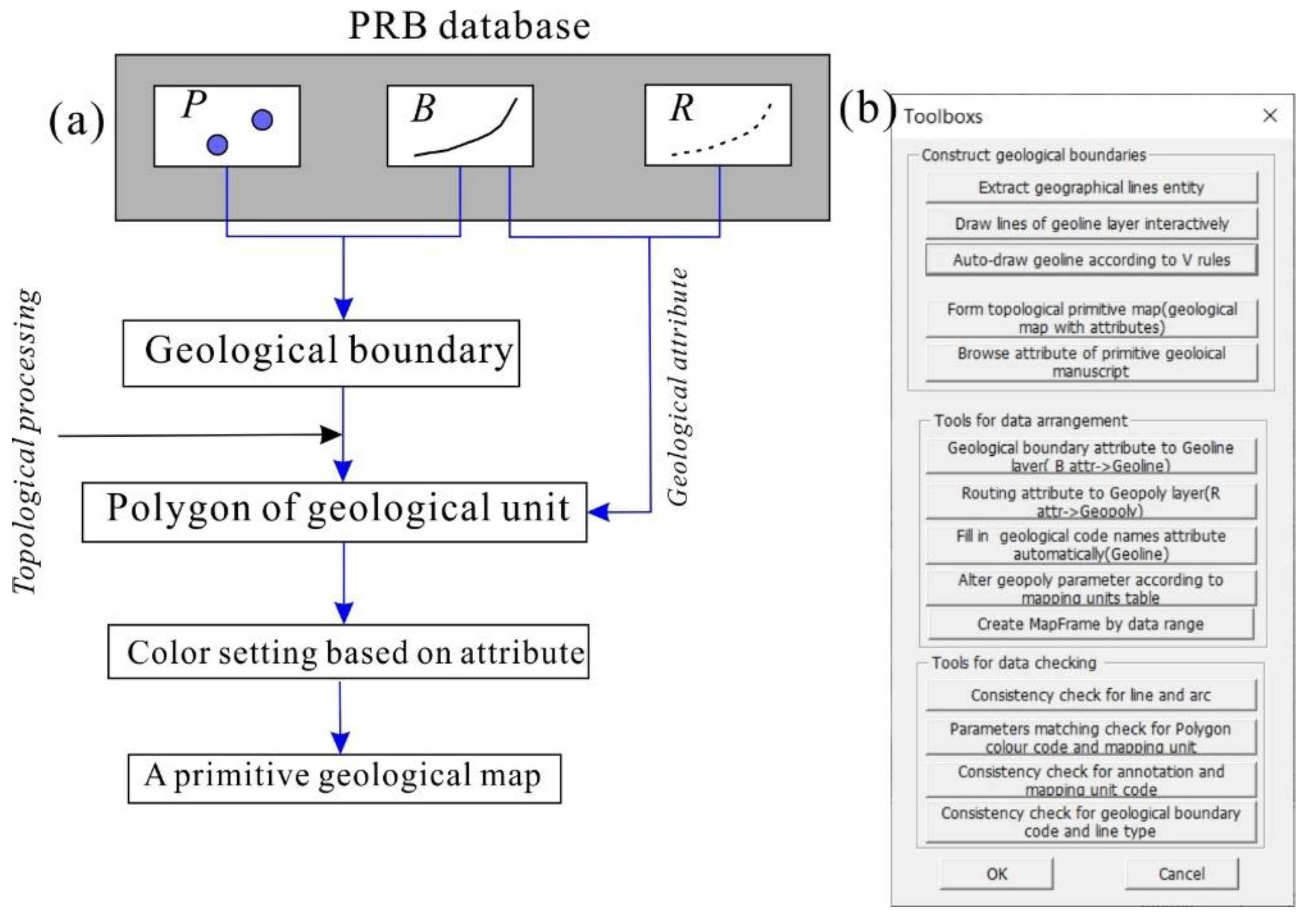
3.4. Field Data Processing, Storage, and Map-Making
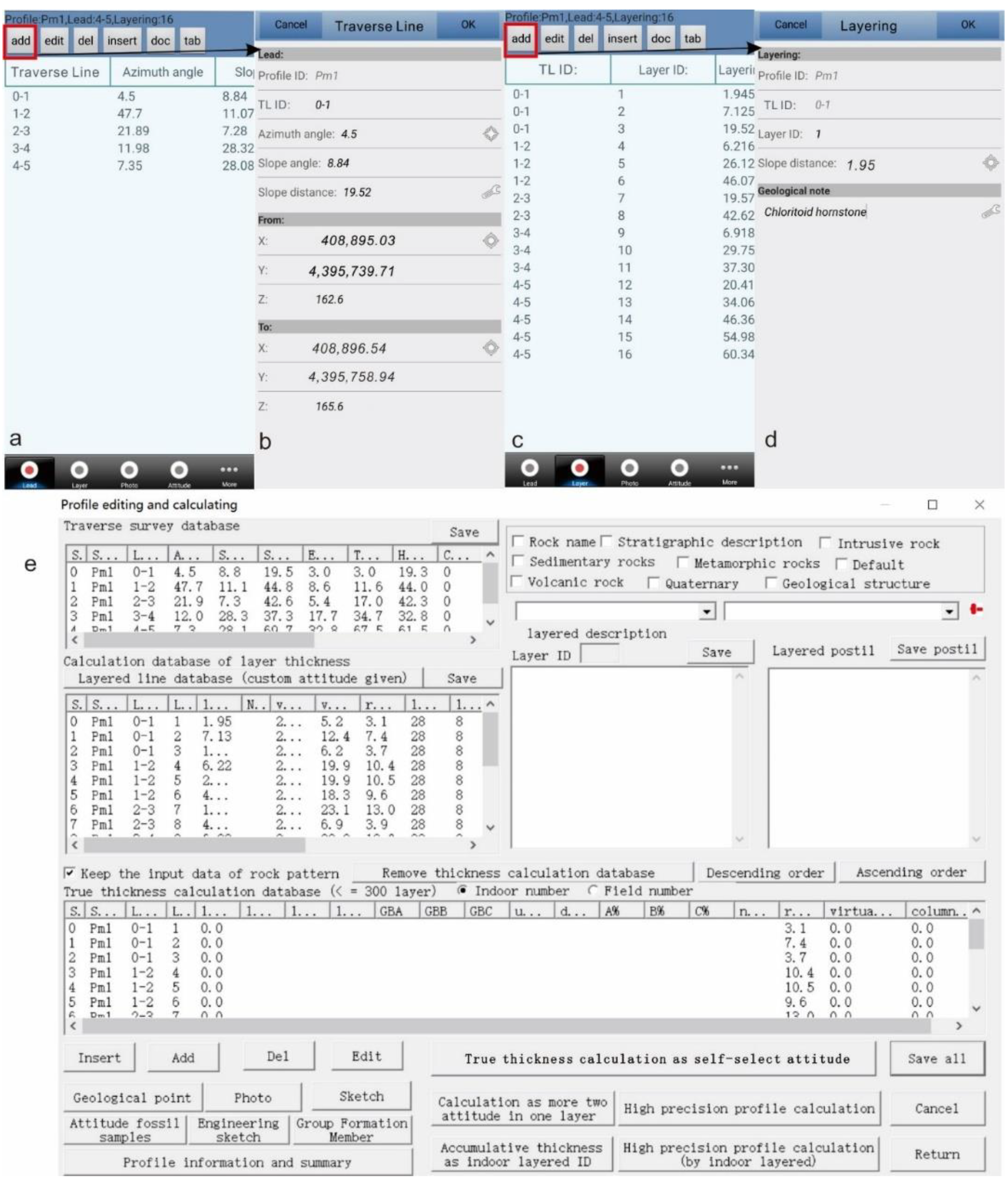
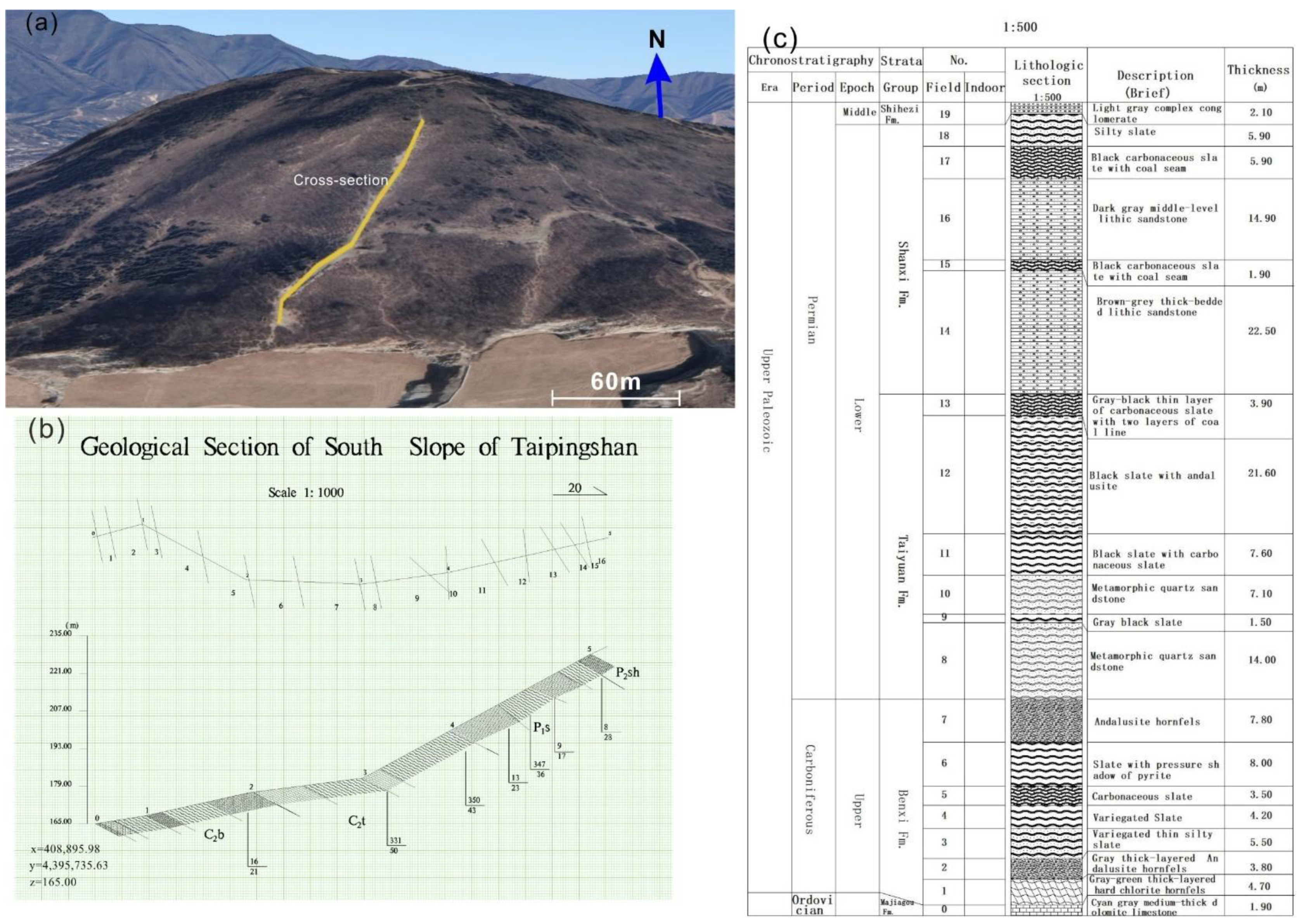
3.5. The Measurement of Geological Cross-Section
4. Results
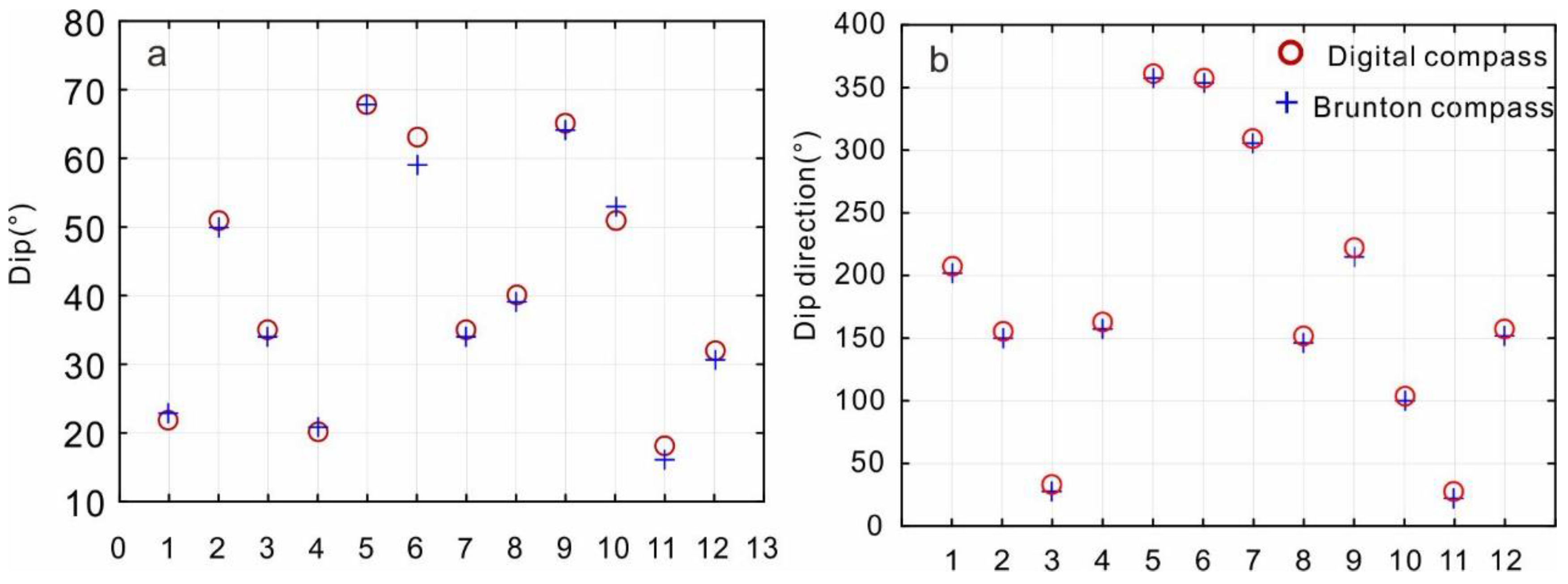
4.1. A Comparison between Digital Compass and Brunton Compass
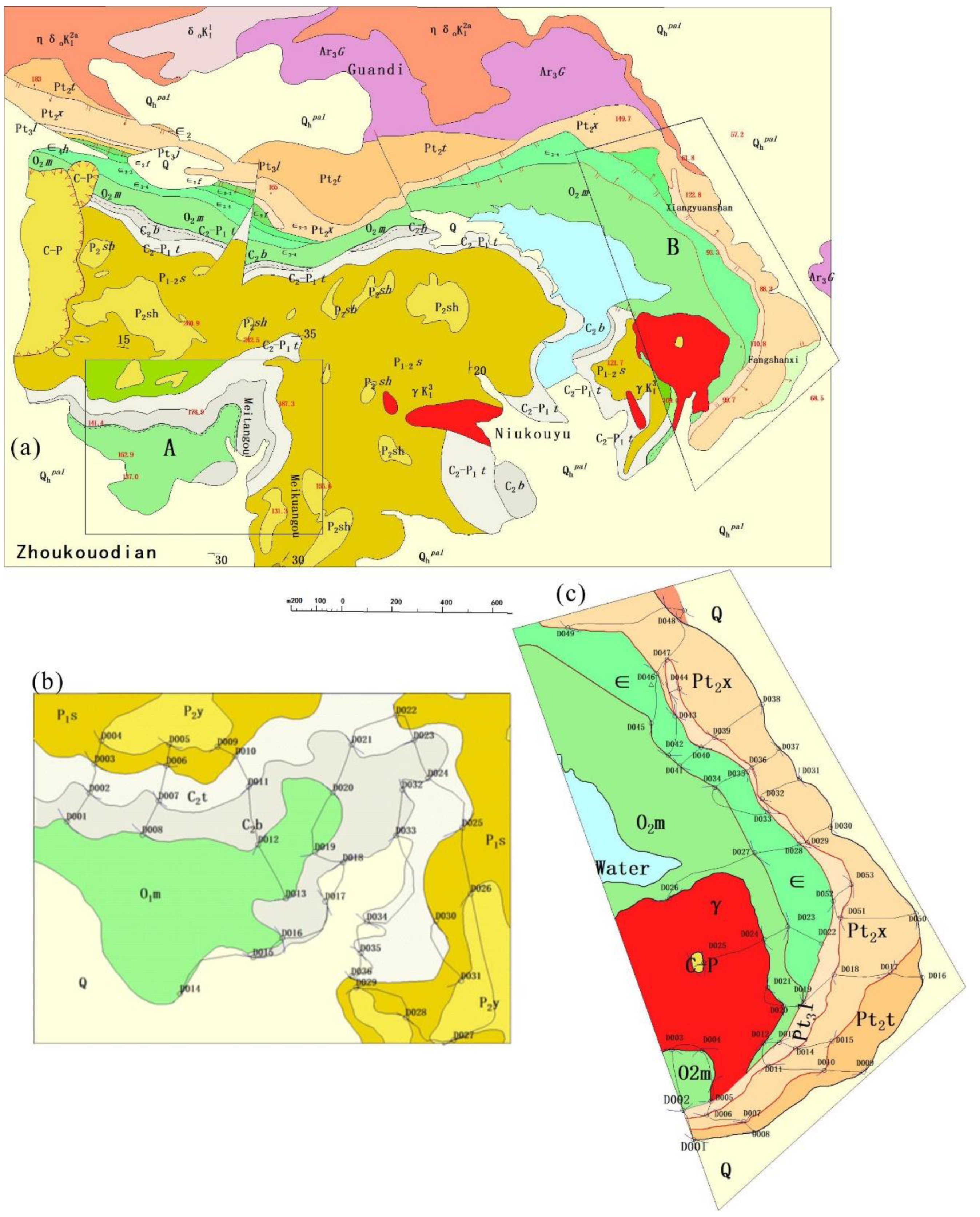
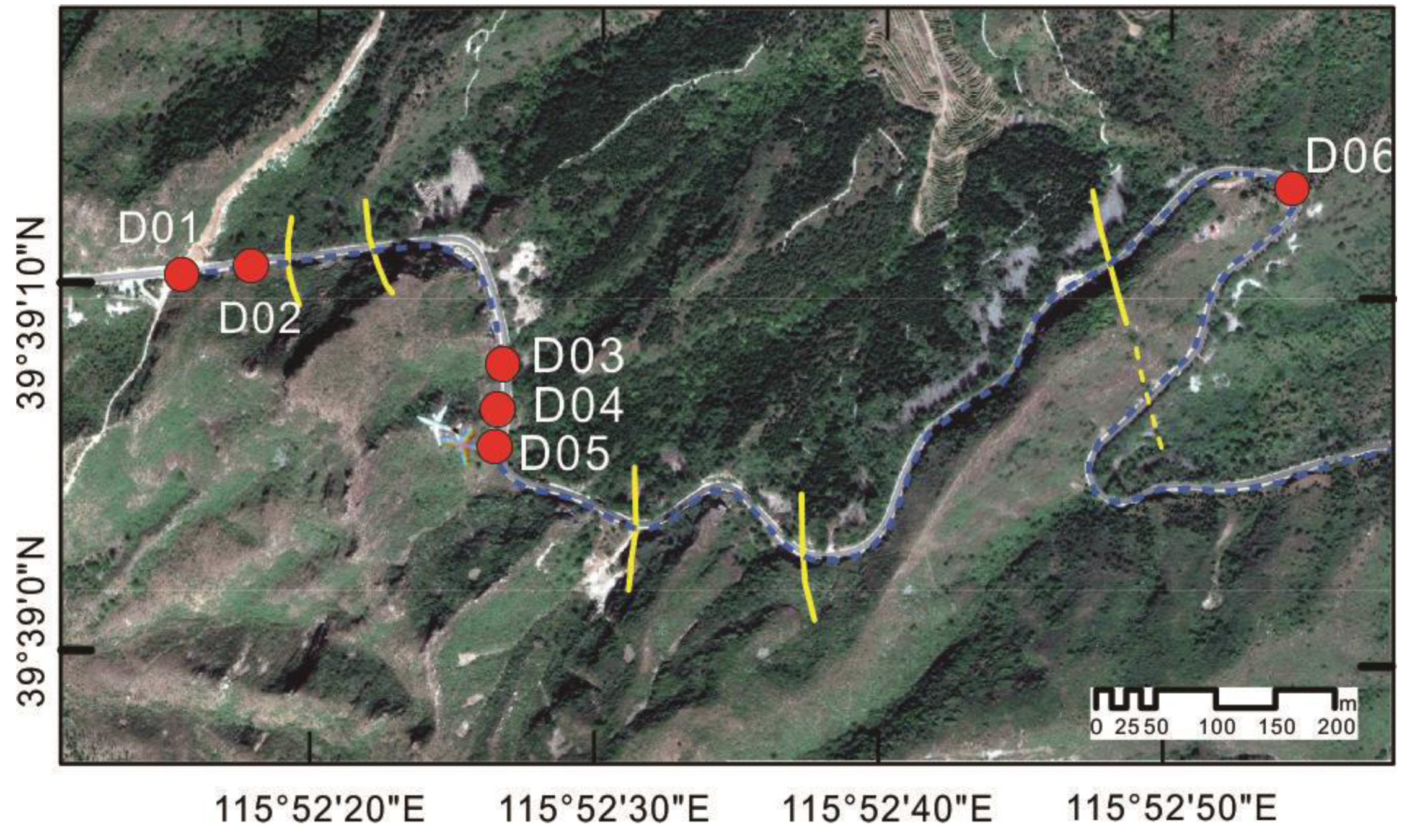
4.2. Geological Mapping Result at the Zhoukoudian Area by Undergraduates
4.3. Geological Cross-Section Survey
5. Discussion
5.1. Experience of DGM-Supported Geological Training in Zhoukoudian
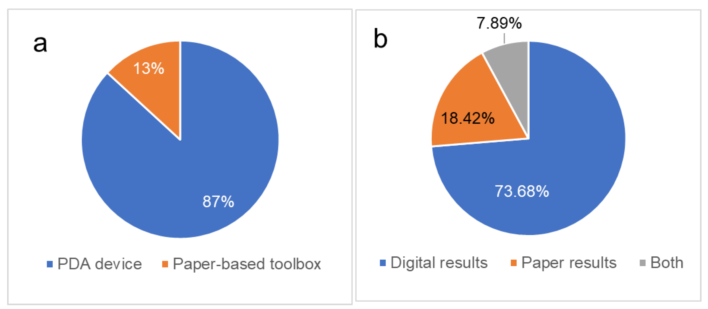
5.2. Students’ Feedback on DGM for Field Geology Training
5.3. Future Development of DGM in Practical Training
6. Conclusions
Supplementary Materials
Author Contributions
Funding
Institutional Review Board Statement
Informed Consent Statement
Data Availability Statement
Acknowledgments
Conflicts of Interest
References
- Hendry, L. Britain’s First Geological Map. Available online: https://www.nhm.ac.uk/discover/first-geological-map-of-britain.html (accessed on 5 April 2021).
- Balestro, G.; Piana, F.; De Donatis, M.; Bruciatelli, L. Representation and transfer of geological knowledge in IT-supported projects. Ital. J. Geosci. 2010, 129, 441–449. [Google Scholar] [CrossRef]
- Vanegas, A. Removing Science Workflow Barriers to Adoption of Digital Geological Mapping by Using the GeoMapper Universal Program and Visual User Interface. In Proceedings of the Digital Mapping Techniques ’01, Tuscaloosa, AL, USA, 20–23 May 2001; Soller, D.R., Ed.; pp. 103–114. [Google Scholar]
- Mookerjee, M.; Vieira, D.; Chan, M.; Gil, Y.; Pavlis, T.; Spear, F.; Tikoff, B. Field Data Management: Integrating Cyberscience and Geoscience. Eos 2015, 96, 18–21. [Google Scholar] [CrossRef]
- Pavlis, T.L.; Langford, R.; Hurtado, J.; Serpa, L. Computer-based data acquisition and visualization systems in field geology: Results from 12 years of experimentation and future potential. Geosphere 2010, 6, 275–294. [Google Scholar] [CrossRef]
- Rogers, D.; McCann, T.; Cooper, A. Integrating paper-based habitat mapping with mobile electronic field recording procedures. Ecol. Inform. 2010, 5, 479–483. [Google Scholar] [CrossRef]
- Whitmeyer, S.J.; De Paor, D.G. Crowdsourcing Digital Maps Using Citizen Geologists. Eos Trans. Am. Geophys. Union 2014, 95, 397–399. [Google Scholar] [CrossRef]
- Brown, K.D.; Sprinkel, D.A. Geologic Field Mapping Using a Rugged Tablet Computer. In Proceedings of the Digital Mapping Techniques ’07— Workshop Proceedings, SC, USA, 20–23 May 2007; Books and Open-file Reports Section, U.S. Geological Survey: Reston, VA, USA, 2008; pp. 53–58. [Google Scholar]
- Clegg, P.; Bruciatelli, L.; Domingos, F.; Jones, R.R.; De Donatis, M.; Wilson, R.W. Digital geological mapping with tablet PC and PDA: A comparison. Comput. Geosci. 2006, 32, 1682–1698. [Google Scholar] [CrossRef]
- De Donatis, M. Earth and Environmental Sciences: Field classes with GIS/GPS and tablet PC. In Proceedings of the First International Workshop on Pen-Based Learning Technologies (PLT 2007), Catania, Italy, 4–5 May 2007. [Google Scholar] [CrossRef]
- De Donatis, M.; Susini, S.; Delmonaco, G. Digital geologic mapping methods: From field to 3D model. Int. J. Geol. 2008, 2, 47–52. [Google Scholar]
- De Donatis, M.; Antonello, A.; Antonello, A.; Susini, S.; Susini, S. BeeGIS: A new open source tool for mobile GIS applications. Rend. Online Soc. Geol. It 2008, 3, 1–3. [Google Scholar]
- Jones, R.R.; McCaffrey, K.J.W.; Clegg, P.; Wilson, R.W.; Holliman, N.S.; Holdsworth, R.E.; Imber, J.; Waggott, S. Integration of regional to outcrop digital data: 3D visualisation of multi-scale geological models. Comput. Geosci. 2009, 35, 4–18. [Google Scholar] [CrossRef]
- Jones, R.R.; McCaffrey, K.J.W.; Wilson, R.W.; Holdsworth, R.E. Digital field data acquisition: Towards increased quantification of uncertainty during geological mapping. Geol. Soc. London Spec. Publ. 2004, 239, 43–56. [Google Scholar] [CrossRef]
- Jordan, C.J.; Napier, B. Developing digital fieldwork technologies at the British Geological Survey. Geol. Soc. London Spec. Publ. 2016, 436, 219–229. [Google Scholar] [CrossRef]
- Oriel, S.S.; Gabrielse, H.; Hay, W.W.; Kottlowski, F.E.; Patton, J.B.; De Vito, S. North American Stratigraphic Code. AAPG Bull. 1983, 67, 841–875. [Google Scholar]
- Wright, B.E.; Stewart, D.B. Digitization of a Geologic Map for the Quebec-Maine-Gulf of Maine Global Geoscience Transect; Books and Open-file Reports Section, U.S. Geological Survey: Reston, VA, USA, 1990. [Google Scholar]
- Williams, V.S.; Selner, G.I.; Taylor, R.B. GSMCAD a New Computer Program that Combines the Functions of the GSMAP and GSMEDIT Programs and Is Compatible with Microsoft Windows and ARC/INFO; Books and Open-file Reports Section, U.S. Geological Survey: Reston, VA, USA, 1996. [Google Scholar]
- Blewett, R.; Hazell, M. User’s Guide to MapPad and AGSO FIELDPAD for the Apple Newton Palmtop Computer; Australian Geological Survey Organisation: Canberra, Australia, 1997. [Google Scholar]
- Brodaric, B. The design of GSC FieldLog: Ontology-based software for computer aided geological field mapping. Comput. Geosci. 2004, 30, 5–20. [Google Scholar] [CrossRef]
- Briner, A.P.; Kronenberg, H.; Mazurek, M.; Horn, H.; Engi, M.; Peters, T. FieldBook and GeoDatabase: Tools for field data acquisition and analysis. Comput. Geosci. 1999, 25, 1101–1111. [Google Scholar] [CrossRef]
- Broome, J.; Brodaric, B.; Viljoen, D.; Baril, D. The Natmap Digital Geoscience Data-Management System. Comput. Geosci. 1993, 19, 1501–1516. [Google Scholar] [CrossRef]
- Geometry Getting Started: Capturing Data with iGIS. Available online: https://www.geometry.com.au/igis/getting-started-capturing-data-with-igis/ (accessed on 5 April 2021).
- Li, C. Guide of Digital Geological Survey System; Geological PublishingHouse: Beijing, China, 2011. [Google Scholar]
- Li, C.; Yang, D.; Li, F.; Liu, C.; Liu, X.; Yu, Q.; Lv, X. Basic framework of the digital geological survey system and applicaiton of its kye technology. Geol. Bull. China 2008, 27, 923–944. [Google Scholar]
- Qingwen, Y.; Li, C.; Kexin, Z.; Donglai, Y.; Yunhai, Z.; Mengchun, G. Digital geological mapping and its development. Earth Sci. China Univ. Geosci. 2003, 28, 370–376. [Google Scholar]
- Liu, G.; Wu, C.; Wang, X. Researchprogressof field working system of computer-aided regional geological survey. Adv. Earth Sci. 2003, 18, 77–84. [Google Scholar]
- Vaughan, A.; Collins, N.; Krus, M.; Rourke, P. Recent development of an earth science app-FieldMove Clino. In Proceedings of the EGU General Assembly Conference Abstracts, Vienna, Austria, 27 April–2 May 2014; p. 14751. [Google Scholar]
- Walker, J.D.; Tikoff, B.; Newman, J.; Clark, R.; Ash, J.; Good, J.; Bunse, E.G.; Möller, A.; Kahn, M.; Williams, R.T.; et al. StraboSpot data system for structural geology. Geosphere 2019, 15, 533–547. [Google Scholar] [CrossRef]
- Lundmark, A.M.; Augland, L.E.; Jørgensen, S.V. Digital fieldwork with Fieldmove—How do digital tools influence geoscience students’ learning experience in the field? J. Geogr. High. Educ. 2020, 44, 427–440. [Google Scholar] [CrossRef]
- Whitmeyer, S.J.; Atchison, C.; Collins, T.D. Using mobile technologies to enhance accessibility and inclusion in field-based learning. GSA Today 2020, 30, 4–10. [Google Scholar] [CrossRef]
- Oliinyk, M.; Bubniak, I.; Vikhot, Y. Using Move software by geological field works. Int. Conf. Young Prof. 2021, 1–5. [Google Scholar] [CrossRef]
- Whitmeyer, S.J.; Pyle, E.J.; Pavlis, T.L.; Swanger, W.; Roberts, L. Modern approaches to field data collection and mapping: Digital methods, crowdsourcing, and the future of statistical analyses. J. Struct. Geol. 2019, 125, 29–40. [Google Scholar] [CrossRef]
- Bowers, D.S. Augmented reality smartphone compasses: Opportunity or oxymoron? In Adjunct Proceedings of the 2019 ACM International Joint Conference on Pervasive and Ubiquitous Computing and Proceedings of the 2019 ACM International Symposium on Wearable Computers, London, UK, 9–13 September 2019; pp. 13–16. [Google Scholar] [CrossRef]
- Liu, G.; Wang, X.; Zhao, W.; Wu, C.; Ouyang, J. The development of computer-aided regional geological mapping system and field practice teaching reform for base class. Chin. Geol. Educ. 2001, 3, 32–35. [Google Scholar]
- Lang, X.; Wang, G.; Wei, Y.; Xu, D.; Li, J. Problems and Solutions of the Application of “Digital Geological Mapping” in Practice Teaching of Universities of Geosciences. Chin. Geol. Educ. 2017, 26, 54–59. [Google Scholar]
- Takegami, M. The origins of modern geology in China: The work of DJ Macgowan and R. Pumpelly. Zinbun 2016, 46, 179–197. [Google Scholar]
- Liu, B.; Ba, J.; Zhang, L.; Nengsong, C.; Xiaoyan, L.; Zejun, Z.; Yanming, Y. Zircon LA-ICP-MS U-Pb Dating of Metamorphism and Anatexis of the Guandi Complex, Zhoukoudian Area, Beijing. Geol. Sci. Technol. Inf. 2008, 27, 37–42. [Google Scholar]
- Li, C.; Qingwen, Y.; Donglai, Y.; Lihua, Q.; Yunhai, Z.; Mengchun, G. Research on PRB digital mapping techniques. Earth Sci. China Univ. Geosci. 2003, 28, 377–383. [Google Scholar]
- Hong, L.I.U.; Lijian, W.A.N.; Yaying, L.U. High precision positioning technology for long distance ocean engineering based on BeiDou Satellite Navigation System. Bull. Surv. Mapp. 2017, 62–66. [Google Scholar] [CrossRef]
- Henry, T.; Murray, J. How does it feel? The affective domain and undergraduate student perception of fieldwork set in a broad pedagogical perspective. Tuning J. High. Educ. 2018, 5, 45–74. [Google Scholar] [CrossRef]
- Mogk, D.W.; Goodwin, C. Learning in the field: Synthesis of research on thinking and learning in the geosciences. Spec. Pap. Geol. Soc. Am. 2012, 486, 131–163. [Google Scholar] [CrossRef]
- Senger, K.; Nordmo, I. Using digital field notebooks in geoscientific learning in polar environments. J. Geosci. Educ. 2020, 69, 166–177. [Google Scholar] [CrossRef]
| Type | Property Information |
|---|---|
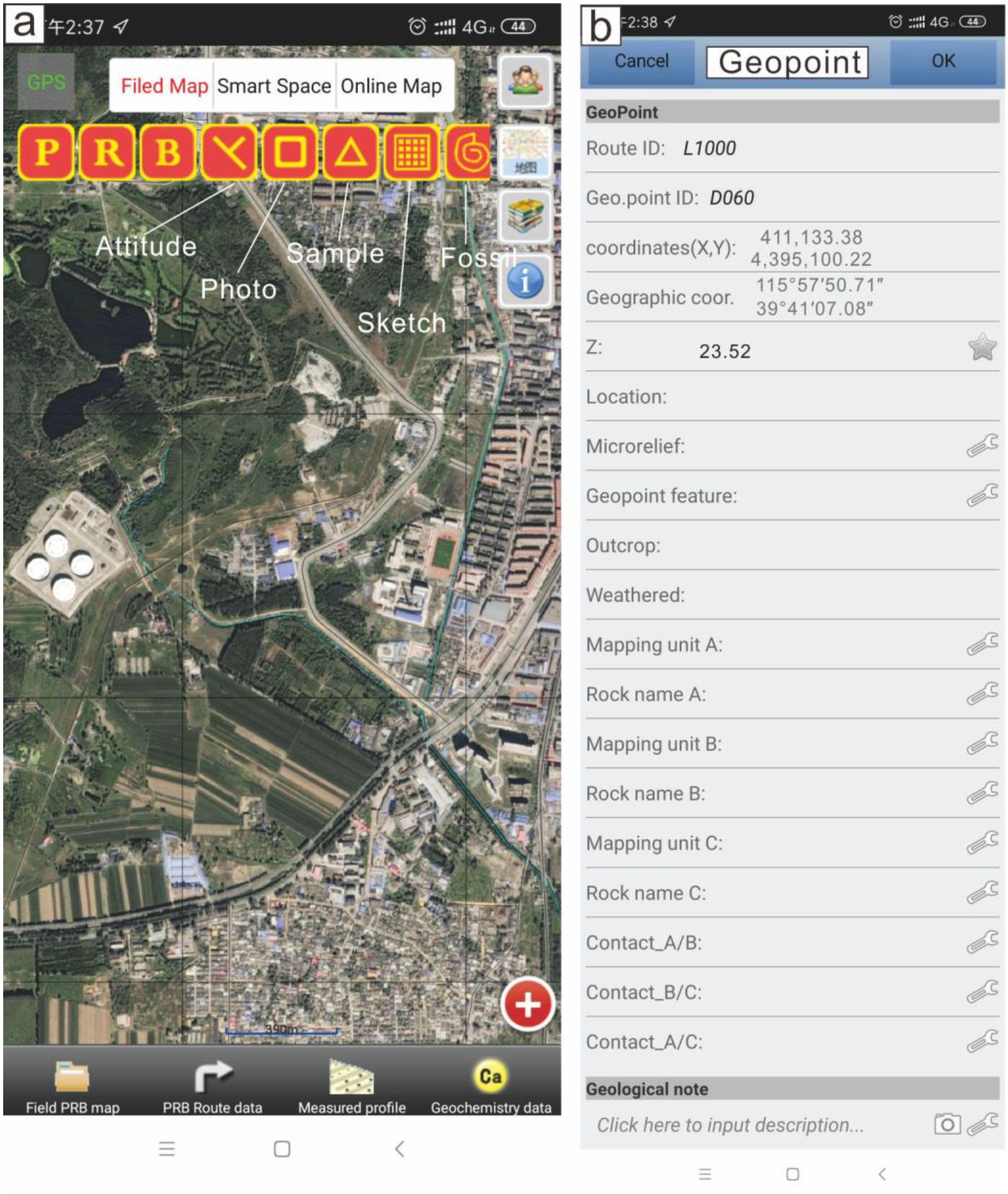
| Geopoint (P) | Route ID, Geopoint (P) ID, Coordinates (X, Y), Geographic coordinates, Z (Elevation), Location, Microrelief, Geopoint feature, Outcrop, Weathered, Mapping unit A, Rock name A, Mapping unit B, Rock name B, Mapping unit C, Rock name C, Contact relation A/B, Contact relation A/C, Contact relation B/C, Geological note |
| Routing (R) | Route ID, Geopoint (P) ID, Routing (R) ID, Direction(degree), Distance, Cumulative distance, Mapping unit, Rock name, Geological note |
| Boundary(B) | Route ID, Geopoint (P) ID, Boundary (B) ID, Boundary (B) type, Routing (R) ID, Contact relation, Left Mapping unit, Right unit, Dip angle, Strike, Dip, geological note |
| Attitude | Route ID, Geopoint (P) ID, Coordinates (X, Y), Geographic coordinate, Routing (R) ID, ID, Dip Angle, strike, dip, Attitude type, Mapping unit, Joint/Gravel measuring data capture |
| Photo | Route ID, Geopoint (P) ID, Coordinates (X, Y), Geographic coordinate, Routing (R) ID, Photo ID, Photo content, Serial number, Total number, Audio ID, Video ID, Photo note |
| Sample | Route ID, Geopoint (P) ID, Coordinates (X, Y), Geographic coordinate, Z (Elevation), Routing (R) ID, Sample ID, Sample content, Serial number, Total number, Audio ID, Video ID, Sample note |
| Sketch | Route ID, Geopoint ID, Coordinate (X, Y), Geographic coordinate, Routing (R) ID, Sketch ID, Sketch name, sketch scale, sketch (Vector), Sketch (Grid), photo of a sketch |
| Fossil | Route ID, Geopoint ID, Coordinates (X, Y), Geographic coordinates, Routing (R) ID, Sample ID, Fossil class, sampling horizon, sampling location, sampling person, sampling data, fossil type. |
| Option | Number | Proportion |
|---|---|---|
| Strong negative | 3 | 7.89% |
| Negative | 4 | 10.53% |
| No influence | 4 | 10.53% |
| Positive | 19 | 50.00% |
| Strong positive | 8 | 21.05% |
| Option | Number | Proportion |
|---|---|---|
| Data structure of DGM | 31 | 81.58% |
| Basic operation of line, point and polygon | 18 | 47.37% |
| Projection parameters and geologicla ajustment | 24 | 63.16% |
| Field data collection | 16 | 42.11% |
| Data import | 17 | 44.74% |
| Comiplition of geological map | 33 | 86.84% |
Publisher’s Note: MDPI stays neutral with regard to jurisdictional claims in published maps and institutional affiliations. |
© 2021 by the authors. Licensee MDPI, Basel, Switzerland. This article is an open access article distributed under the terms and conditions of the Creative Commons Attribution (CC BY) license (https://creativecommons.org/licenses/by/4.0/).
Share and Cite
Wang, C.; Wang, X.; Chen, J. Digital Geological Mapping to Facilitate Field Data Collection, Integration, and Map Production in Zhoukoudian, China. Appl. Sci. 2021, 11, 5041. https://doi.org/10.3390/app11115041
Wang C, Wang X, Chen J. Digital Geological Mapping to Facilitate Field Data Collection, Integration, and Map Production in Zhoukoudian, China. Applied Sciences. 2021; 11(11):5041. https://doi.org/10.3390/app11115041
Chicago/Turabian StyleWang, Chengbin, Xinqing Wang, and Jianguo Chen. 2021. "Digital Geological Mapping to Facilitate Field Data Collection, Integration, and Map Production in Zhoukoudian, China" Applied Sciences 11, no. 11: 5041. https://doi.org/10.3390/app11115041
APA StyleWang, C., Wang, X., & Chen, J. (2021). Digital Geological Mapping to Facilitate Field Data Collection, Integration, and Map Production in Zhoukoudian, China. Applied Sciences, 11(11), 5041. https://doi.org/10.3390/app11115041


