Mapping Forest Fire Risk and Development of Early Warning System for NW Vietnam Using AHP and MCA/GIS Methods

 ,
,  ,
, 


Abstract
1. Introduction
1.1. Environmental Factors Affecting Forest Fire
1.1.1. Terrain
1.1.2. Combustible Fuel
1.1.3. Weather Conditions
1.1.4. Human Impact
1.2. Aim, Objectives and Data Sources
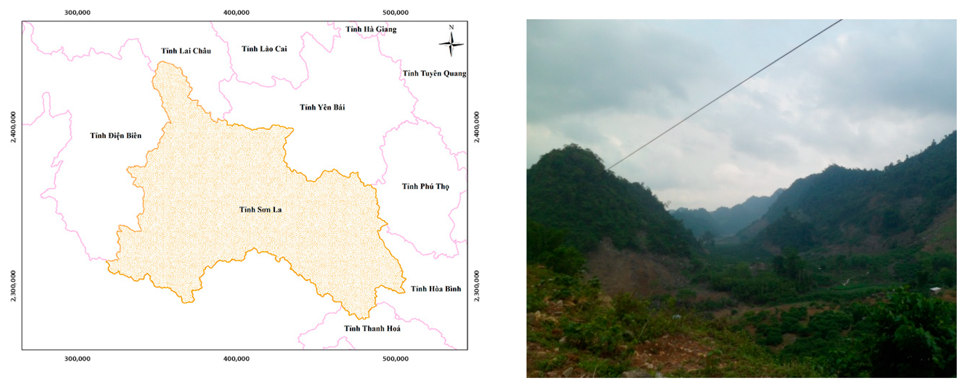
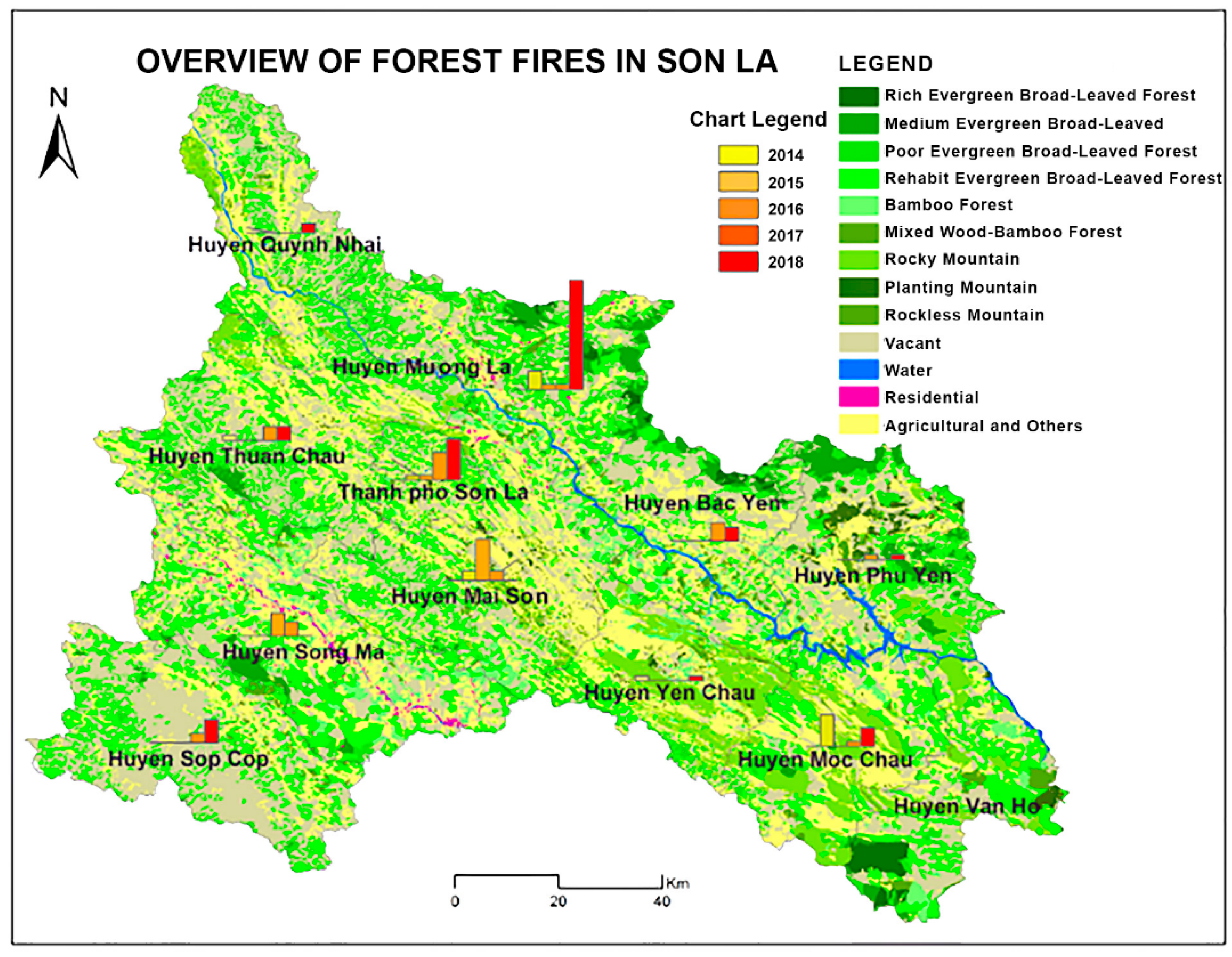
2. Study Area
3. Methods
3.1. Satellite Remote Sensing Mapping and Multi-Criteria Analysis (MCA)
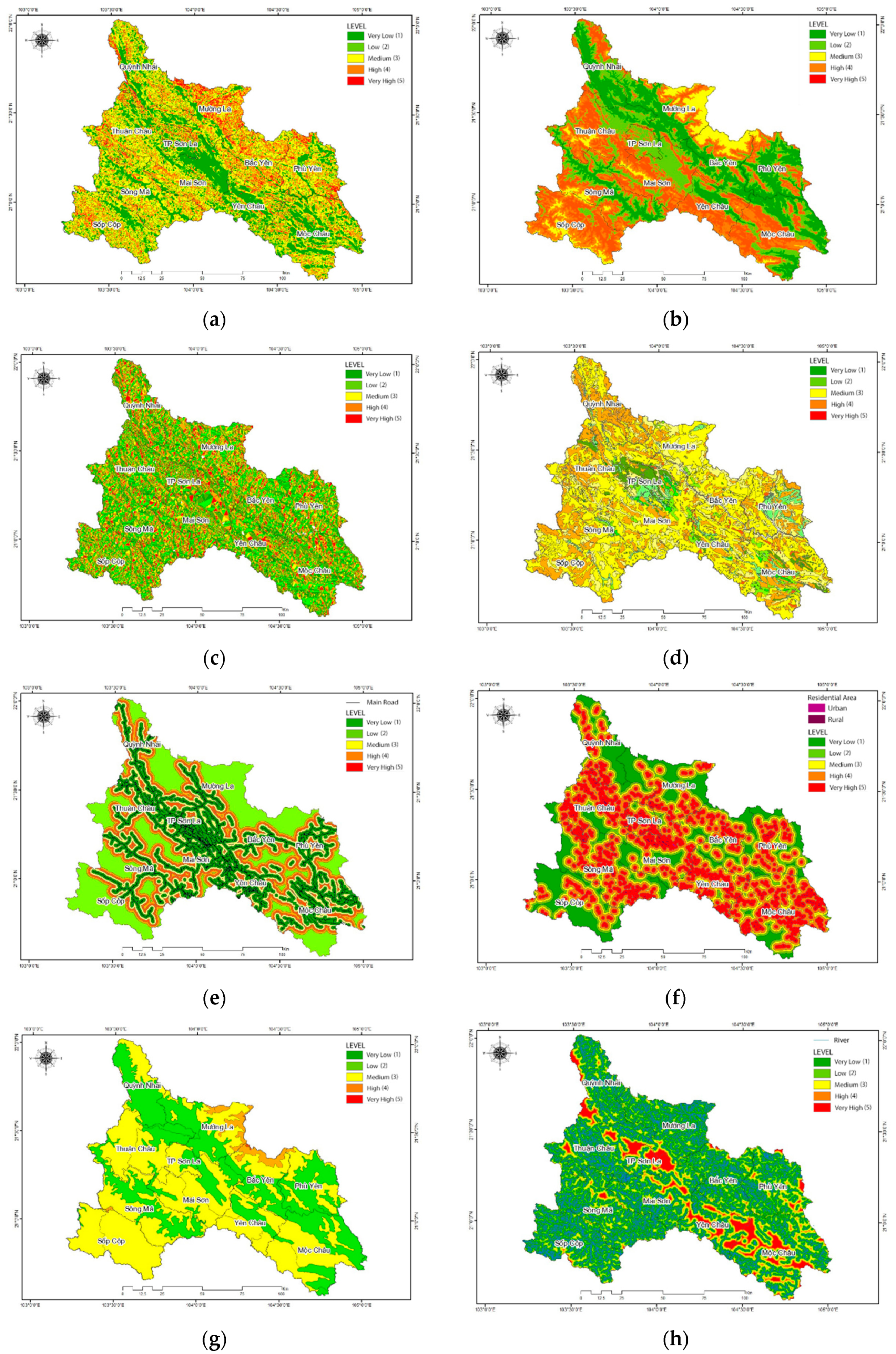
3.2. Development of the Forest Fire Risk Map
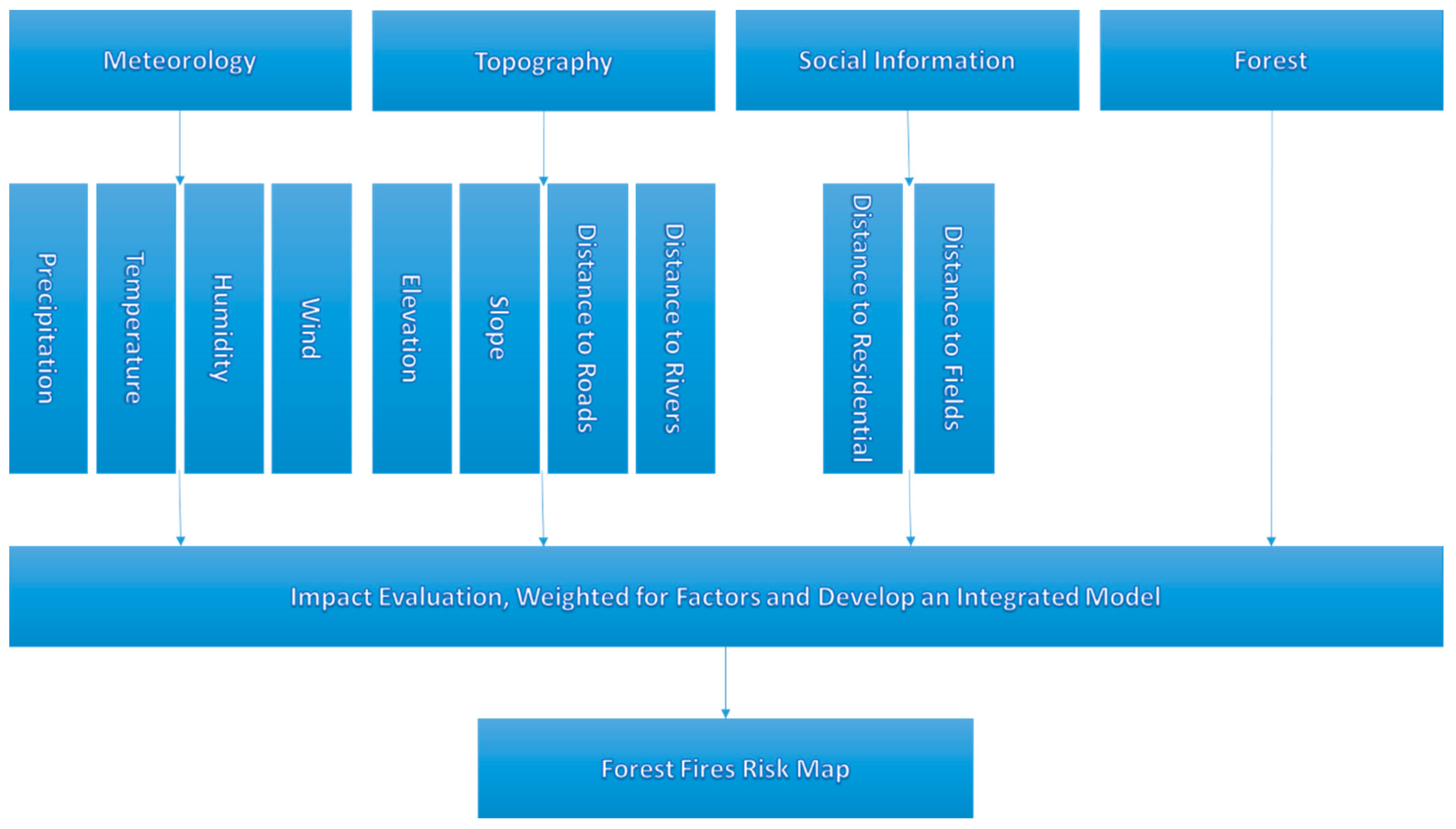
3.3. Data Integration
3.4. Creation of a Database for Forest Fires
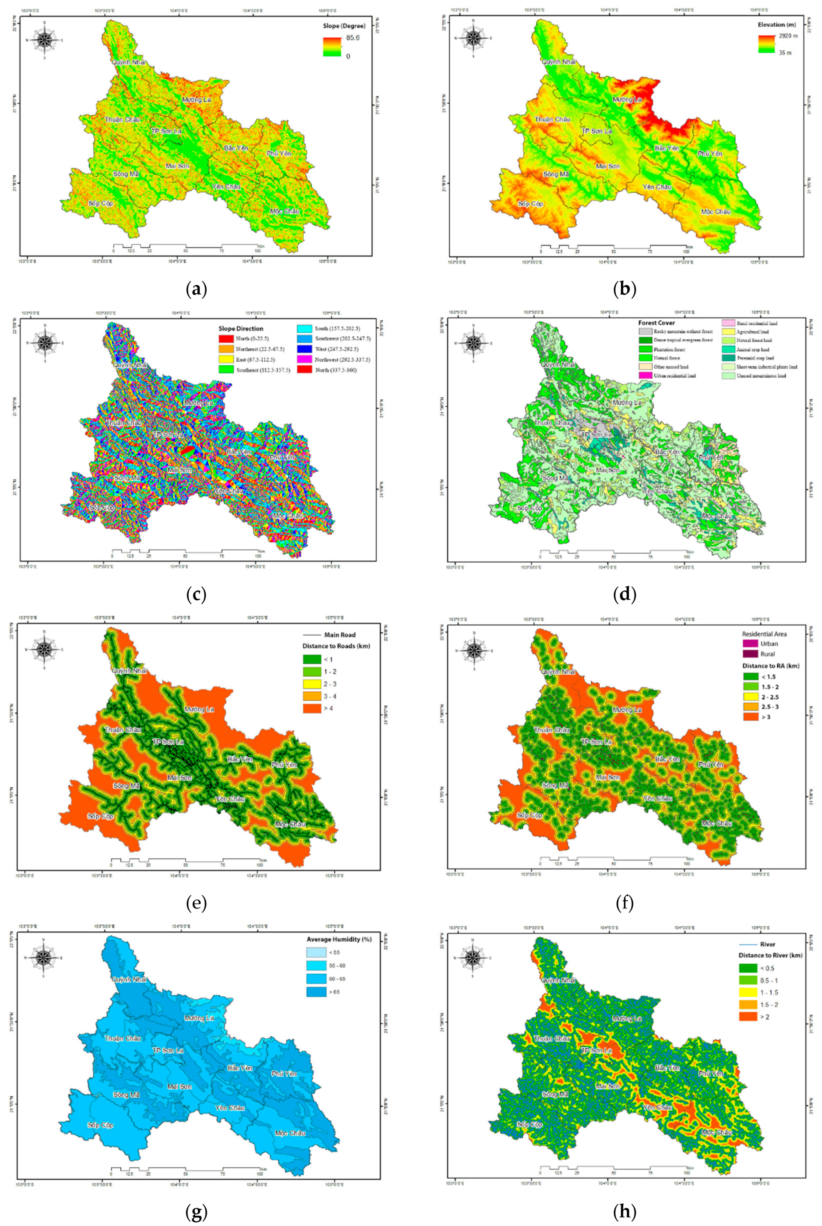
- Digital elevation model (DEM), slope and gradient data extracted from the 1:100,000 topographic map. Forest data collected from the provincial forest management department, corrected and supplemented with the Landsat satellite image.
- Population distribution and distance to residential areas. Distance to roads, data on rivers and streams and the density of rivers and streams in the study area.
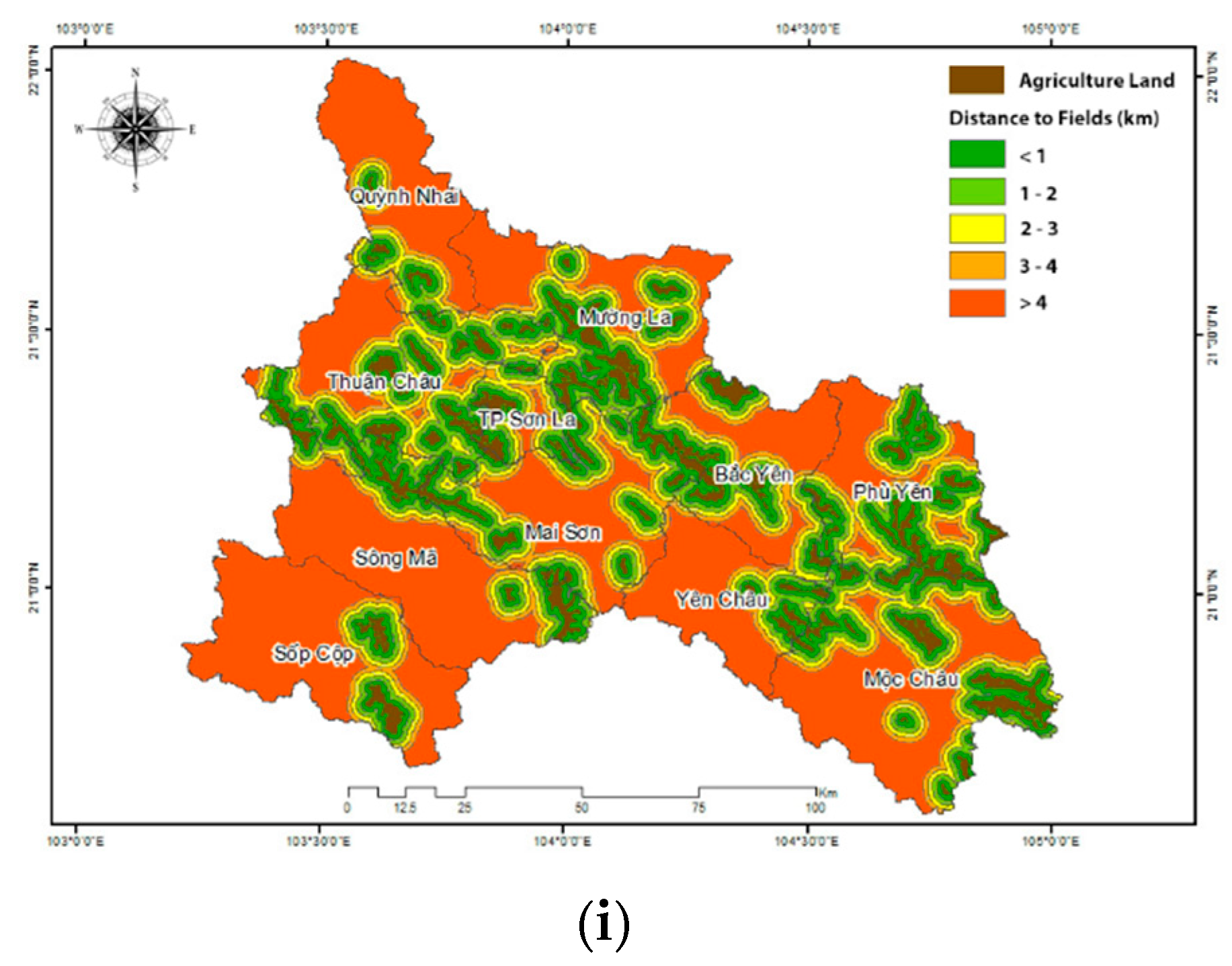
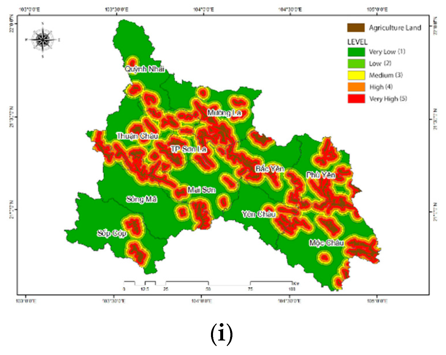
- Current status of upland fields and distance to upland fields (currently, the slash and burn form of agriculture in the upland field area still exists in the mountainous regions of Vietnam. Every year, people adopt the slash and burn method before planting a new crop without following any specific procedure or law. This causes many forest fires. Forest areas closer to the slash and burn agricultural areas have a higher potential for forest fires. Since these field locations are usually far from the villages, the distance to the upland fields is one of the main factors to assess forest fire risk.
- Data on monthly average humidity, based on the meteorological data of the study area (33-years of statistic data from the Central Meteorological and Hydrological Station).
3.5. Evaluation of Information Layers for Assessment of Forest Fire Risk
3.6. Determining the Weights of the Components Contributing to Fire Risk
4. Results
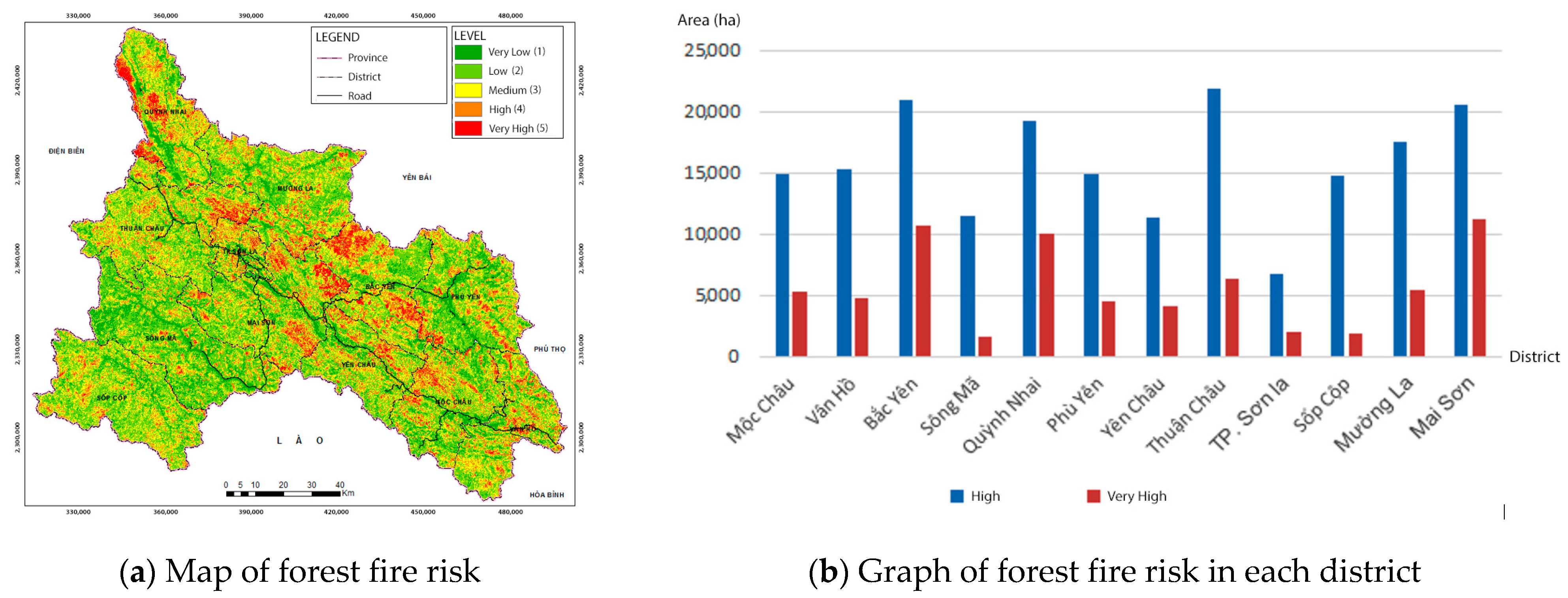
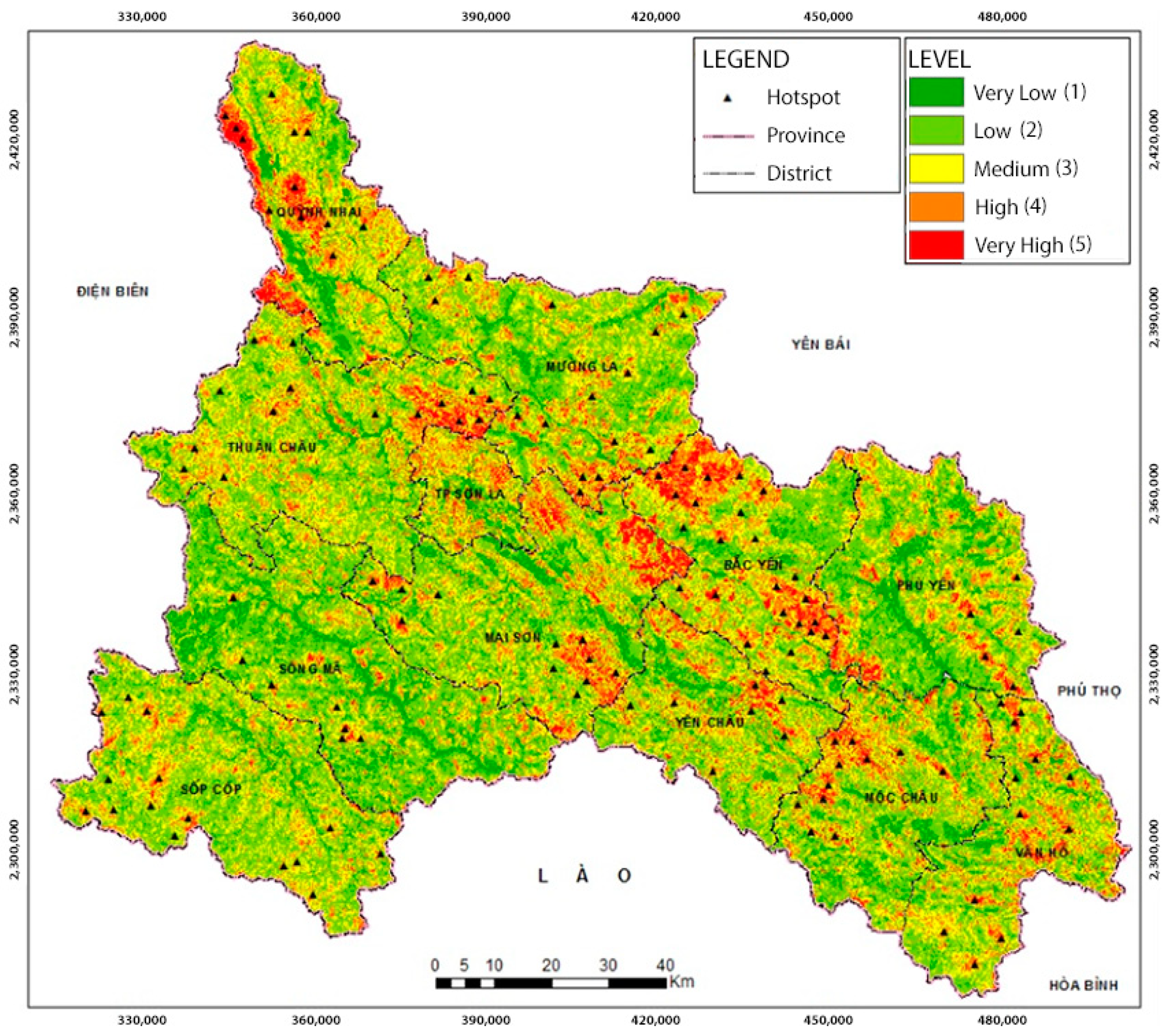
4.1. Fire Risk Mapping and Integration Equation
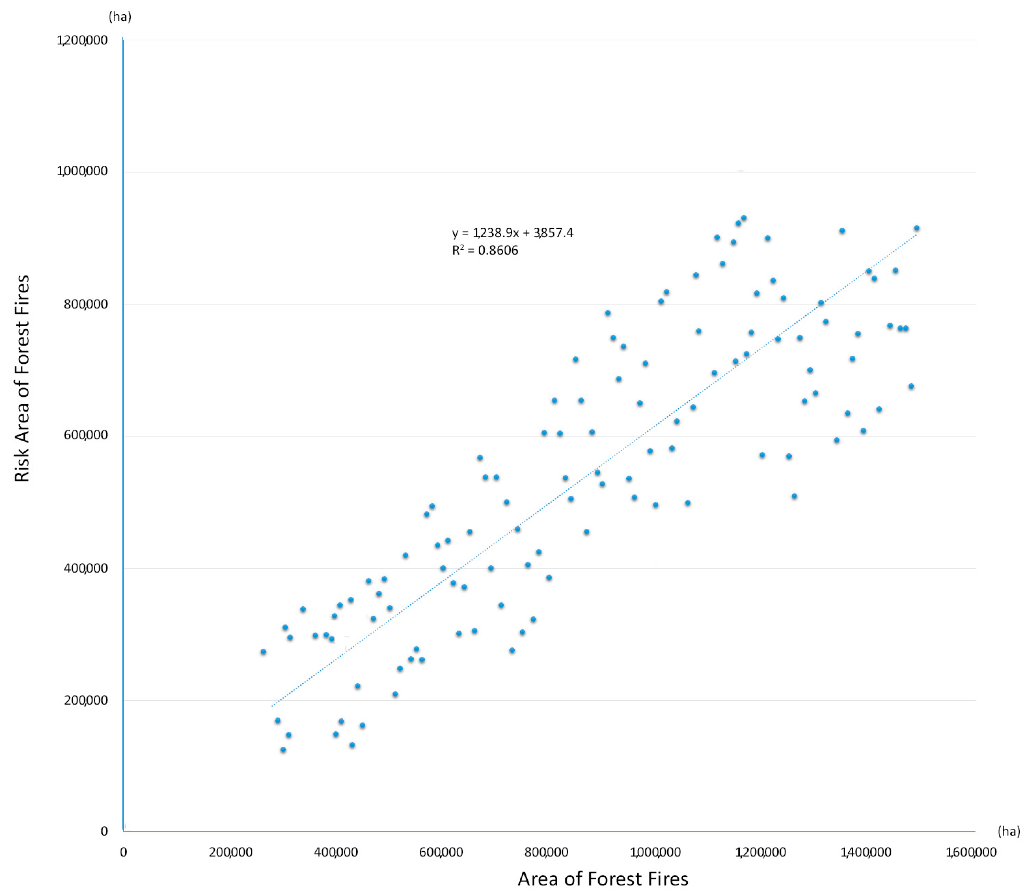
4.2. Evaluation of Model Reliability
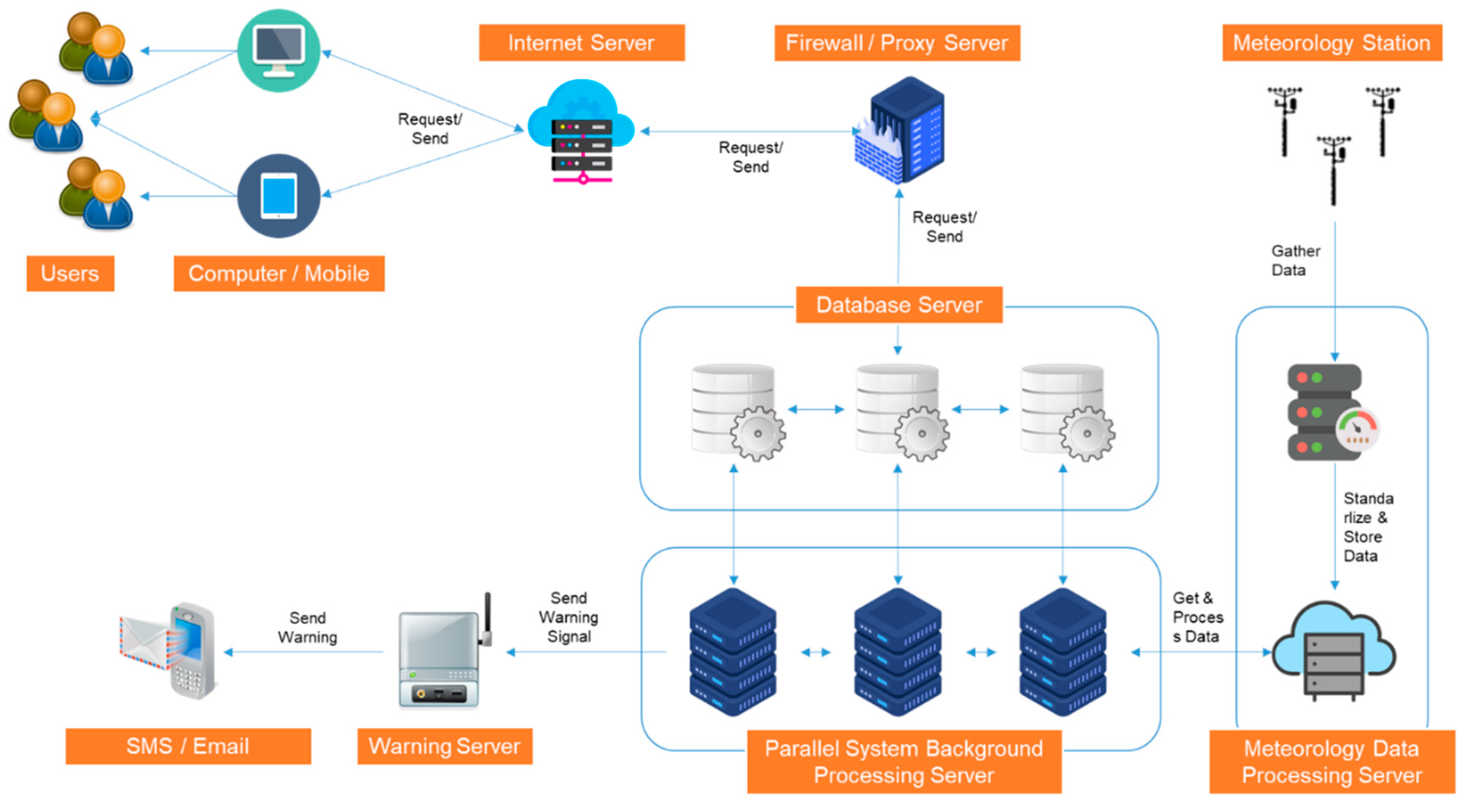
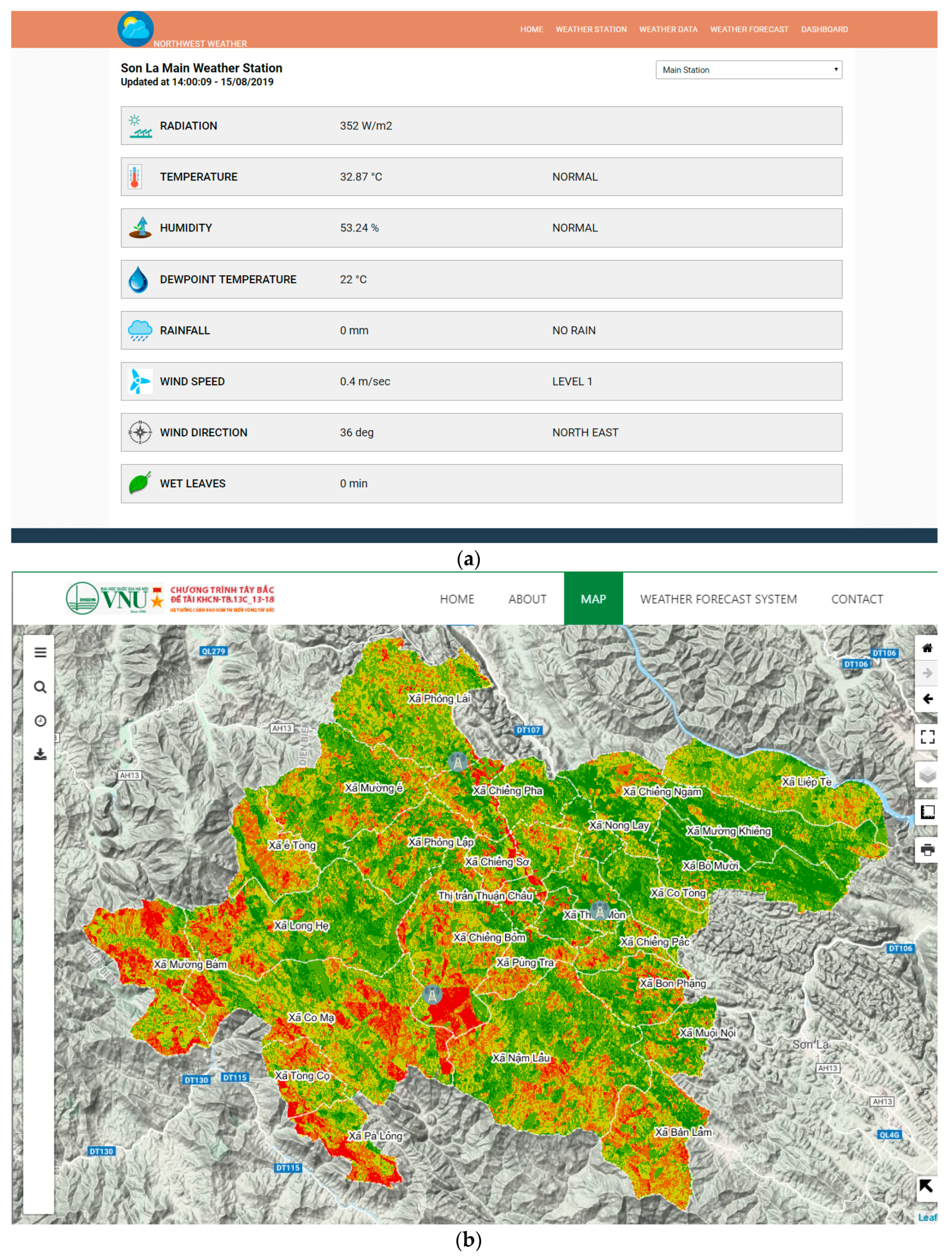
4.3. Early Warning System
4.3.1. Software Database
4.3.2. Software Function
5. Discussion and Conclusions
Author Contributions
Funding
Acknowledgments
Conflicts of Interest
References
- Yusuf, A.A.; Francisco, H.A. Climate Change Vulnerability Mapping for Southeast Asia; EFPSEA: Singapore, 2009. [Google Scholar]
- Asian Development Bank. Vietnam: Environment and Climate Change Assessment; Publication Stock No. RPS135693; Asian Development Bank: Manila, Philippines, 2013; ISBN 978-92-9254-131-6; ISBN 978-92-9254-132-3. [Google Scholar]
- Le, T.H.; Nguyen, T.N.T.; Lasko, K.; Ilavajhala, S.; Vadrevu, K.P.; Justice, C. Vegetation fires and air pollution in Vietnam. Environ. Pollut. 2014, 195, 267–275. [Google Scholar] [CrossRef] [PubMed]
- Vadrevu, K.P.; Lasko, K.; Giglio, L.; Schroeder, W.; Biswas, S.; Justice, C. Trends in vegetation fires in South and Southeast Asian countries. Sci. Rep. 2019, 9, 7422. [Google Scholar] [CrossRef] [PubMed]
- FAO. Fire Management—Global Assessment 2006. A Thematic Study Prepared in the Framework of the Global Forest Resources Assessment 14 2005; FAO: Rome, Italy, 2007; Available online: http://www.fao.org/docrep/009/a0969e/a0969e00.htm (accessed on 6 December 2019).
- Forest Fire Statistic Ddata 2015. Available online: http://thoibaotaichinhvietnam.vn/pages/xa-hoi/2016-03-04/ca-nuoc-xay-ra-2792-vu-chay-trong-nam-2015-29279.aspx (accessed on 6 December 2019).
- Fatih, S.; Bülent, S.; Abdullah, E.A.; Nuri, B. Evaluation of Forest Fire Risk with GIS. Pol. J. Environ. Stud. 2014, 23, 187–194. [Google Scholar]
- Wen, C.; He, B.; Quan, X.; Liu, X. Wildfire Risk Assessment Using Multi-Source Remote Sense Derived Variables. In Proceedings of the IGARSS 2018—2018 IEEE International Geoscience and Remote Sensing Symposium, Valencia, Spain, 23–27 July 2018; pp. 7644–7647. [Google Scholar]
- Teodoro, A.C.; Duarte, L. Forest fire risk maps: A GIS open source application—A case study in Norwest of Portugal. Int. J. Geogr. Inf. Sci. 2013, 27, 699–720. [Google Scholar] [CrossRef]
- Xu, D.; Shao, G.; Dai, L.; Hao, Z.; Tang, L.; Wang, H. Mapping forest fire risk zones with spatial data and principal component analysis. Sci. China Ser. E Technol. Sci. 2006, 49, 140–149. [Google Scholar] [CrossRef]
- Natural and Social-Economic Conditions in Son La. Available online: http://sotnmt.sonla.gov.vn/NewsDetail.aspx?id=43 (accessed on 6 August 2019).
- Jain, A.; Ravan, S.A.; Singh, R.K.; Das, K.K.; Roy, P.S. Forest fire risk modelling using remote sensing and geographic information systems. Curr. Sci. 1996, 70, 928–933. [Google Scholar]
- Keane, R.E.; Drury, S.A.; Karau, E.C.; Hessburg, P.F.; Reynolds, K.M. A method for mapping fire hazard and risk across multiple scales and its application in fire management. Ecol. Model. 2010, 221, 2–18. [Google Scholar] [CrossRef]
- Countryman, C.M. The Fire Environment Concept; USDA, Forest Service, Pacific Southwest Forest and Range Experiment Station: Berkeley, CA, USA, 1972; p. 12.
- Thom, L.D. Scientific Forest Fire Level Prediction in Northern Central Provinces, Forest Protection Department; Vietnam Ministry of Agriculture and Development: Hanoi, Vietnam, 2012. [Google Scholar]
- Hardwick, P.E.; Lachowski, H.; Forbes, J.; Olson, R.J.; Roby, K.; Fites, J. Fuel loading and risk assessment Lassen National Forest. In Proceedings of the Seventh Forest Service Remote Sensing Applications Conference, Nassau Bay, TX, USA, 6–10 April 1998. [Google Scholar]
- Rothermel, R.C. A Mathematical Model for Predicting Fire Spread in Wildland Fuels; Res. Pap. INT-115; U.S. Department of Agriculture, Intermountain Forest and Range Experiment Station: Ogden, UT, USA, 1972; p. 40. [Google Scholar]
- Kuter, N.; Yenilmez, F.; Kuter, S. Forest fire risk mapping by Kernel density estimation. Croat. J. For. Eng. J. Theory Appl. For. Eng. 2011, 32, 599–610. [Google Scholar]
- Hoang, M.H. Status of forest fire management and control in Vietnam. In Proceedings of the GEOSS AP Symposium Integrated Observation for Sustainable Development in the Asia-Pacific Region, Tokyo, Japan, 11–12 January 2007. [Google Scholar]
- Website of General Statistics Office of Vietnam. Available online: https://www.gso.gov.vn/ (accessed on 29 May 2020).
- Vietnam Administration of Forestry. Available online: http://www.kiemlam.org.vn (accessed on 6 December 2019).
- Saaty, T.L. An exposition of the AHP in reply to the paper Remarks on the Analytic Hierarchy Process. Manag. Sci. 1990, 36, 259–268. [Google Scholar] [CrossRef]
- Rao, K.R. Wind Energy: Technical Considerations-Contents. In Wind Energy for Power Generation; Springer: Cham, Switzerland, 2019. [Google Scholar]
- Cansler, C.A.; McKenzie, D.; Halpern, C.B. Fire enhances the complexity of forest structure in alpine treeline ecotones. Ecosphere 2018, 9, e02091. [Google Scholar] [CrossRef]
- Keane, R.E.; Rollins, M.G.; Zhu, Z. Using simulated historical time series to prioritize fuel treatments on landscapes across the United States: The LANDFIRE prototype project. Ecol. Model. 2007, 204, 485–502. [Google Scholar] [CrossRef]
- Mastura, M. Forest Fire Monitoring and Mapping in South East Asia, Department of Geography, Universiti Kebangsaan Malaysia. In Proceedings of the National Seminar on LUCC and GOFC (NASA/EOC), Bangi, Malaysia, 12 November 1999. [Google Scholar]
- Tung, N.C. Applied Research, Assay, Development of a Number of Modules for Monitoring Forest Resource Development and Forest Resource Management; Forest Inventory and Planning Institute: Hanoi, Vietnam, 2007. [Google Scholar]
- Costa Freitas, M.D.B.; Xavier, A.; Fragoso, R. Integration of Fire Risk in a Sustainable Forest Management Model. Forests 2017, 8, 270. [Google Scholar] [CrossRef]
- Beer, T. The Interaction of Wind and Fire. Bound. Layer Meteorol. 1991, 54, 287–308. [Google Scholar] [CrossRef]
- Gumus, S. An Evaluation of Stakeholder Perception Differences in Forest Road Assessment Factors Using the Analytic Hierarchy Process (AHP). Forests 2017, 8, 165. [Google Scholar] [CrossRef]
- Whitman, E.; Parisien, M.-A.; Thompson, D.K.; Flannigan, M.D. Topoedaphic and Forest Controls on Post-Fire Vegetation Assemblies Are Modified by Fire History and Burn Severity in the Northwestern Canadian Boreal Forest. Forests 2018, 9, 151. [Google Scholar] [CrossRef]
- Garcia, C.; Fearnley, C.J. Evaluating critical links in early warning systems for natural hazards. Environ. Hazards 2012, 11, 123–137. [Google Scholar] [CrossRef]
- Michoud, C.; Bazin, S.; Blikra, L.H.; Derron, M.H.; Jaboyedoff, M. Experiences from site-specific landslide early warning systems. Nat. Hazards Earth Syst. Sci. 2013, 13, 2659–2673. [Google Scholar] [CrossRef]
- Kelman, I.; Glantz, M.H. Early warning systems defined. In Reducing Disaster: Early Warning Systems for Climate Change; Zommers, Z., Singh, A., Eds.; Springer: Dordrecht, The Netherlands, 2014; pp. 89–108. [Google Scholar] [CrossRef]
- Lumbroso, D.; Brown, E.; Ranger, N. Stakeholders’ perceptions of the overall effectiveness of early warning systems and risk assessments for weather-related hazards in Africa, the Caribbean and South Asia. Nat. Hazards 2016, 84, 2121–2144. [Google Scholar] [CrossRef]
- Huyen, D.T.; Tuan, V.A. Applying GIS and multicriteria evaluation in forest fire risk zoning in Son La province, Vietnam. In Proceedings of the International Conference on Geo-information Spatial-Infrastructure Development, Hanoi, Vietnam, 22–25 November 2018; pp. 9–11. [Google Scholar]


| ID | Land Use | Area (ha) | Area (%) |
|---|---|---|---|
| 1 | Residential | 4873 | 0.29 |
| 2 | Agricultural land, other land | 390,917.70 | 22.88 |
| 3 | Vacant land | 605,797 | 35.46 |
| 4 | Water surface | 25,728.40 | 1.51 |
| 5 | Rocky mountains without trees | 7147.6 | 0.4 |
| 6 | Mixed bamboo, wood forest | 16,928.30 | 0.99 |
| 7 | Rich evergreen broad leaved forest | 11,023 | 0.65 |
| 8 | Poor evergreen broad leaved forest | 62,970.80 | 3.69 |
| 9 | Restored evergreen broad leaved forest | 368,903.20 | 21.59 |
| 10 | Medium evergreen broad leaved forest | 46,886.70 | 2.74 |
| 11 | Rocky mountain forest | 91,500.30 | 5.36 |
| 12 | Bamboo forest | 56,748 | 3.32 |
| 13 | Planted forest | 19,147.90 | 1.12 |
| Total | 1,708,571.90 | 100.00 |
| Assessment Level | Slope (Degree) | Elevation (m) | Distance to Roads (km) | Slope Direction | Distance to River/Stream (m) | Humidity (%) | Distance to Residential Areas (km) | Distance to Fields (m) |
|---|---|---|---|---|---|---|---|---|
| 1—Very low | 0°–8° | <1100 | >2 | North Southeast | <200 | 60–100 | <1.5 | >400 |
| 2—Low | 8°–15° | 1100–1200 | 1.5–2 | Northeast | 200–400 | 55–60 | 1.5–2 | 350–400 |
| 3—Medium | 15°–25° | 1200–1300 | 1–1.5 | Southeast | 400–600 | 50–55 | 2–2.5 | 300–350 |
| 4—High | 25°–45° | 1300–1600 | 0.5– 1 | Southwest Northwest | 600–800 | 45–50 | 2.5–3 | 200–300 |
| 5—Very high | >45° | >1600 | <0.5 | West | >800 | <45 | >3 | <200 |
| Indicator | FC | HM | EL | DT | SL | SD | SI | UF | RA | Weight |
|---|---|---|---|---|---|---|---|---|---|---|
| FC | 0.26 | 0.23 | 0.28 | 0.34 | 0.26 | 0.23 | 0.20 | 0.18 | 0.16 | 0.24 |
| HM | 0.26 | 0.23 | 0.28 | 0.23 | 0.20 | 0.18 | 0.16 | 0.14 | 0.16 | 0.20 |
| EL | 0.13 | 0.12 | 0.14 | 0.11 | 0.26 | 0.23 | 0.20 | 0.11 | 0.14 | 0.16 |
| DT | 0.09 | 0.12 | 0.14 | 0.11 | 0.13 | 0.12 | 0.12 | 0.14 | 0.11 | 0.12 |
| SL | 0.06 | 0.08 | 0.03 | 0.06 | 0.07 | 0.12 | 0.16 | 0.14 | 0.14 | 0.09 |
| SD | 0.06 | 0.08 | 0.03 | 0.06 | 0.03 | 0.06 | 0.08 | 0.11 | 0.11 | 0.07 |
| SI | 0.05 | 0.06 | 0.03 | 0.04 | 0.02 | 0.03 | 0.04 | 0.14 | 0.11 | 0.06 |
| UF | 0.05 | 0.06 | 0.05 | 0.03 | 0.02 | 0.02 | 0.01 | 0.04 | 0.05 | 0.04 |
| RA | 0.04 | 0.04 | 0.03 | 0.03 | 0.01 | 0.01 | 0.01 | 0.02 | 0.03 | 0.02 |
| No. | District | 2011 | 2012 | 2013 | 2014 | 2015 | Level IV, V Risk Region Area (ha) | |
|---|---|---|---|---|---|---|---|---|
| 1 | Moc Chau | 0 | 1 | 1 | 1 | 8 | 11 | 12,342.4 |
| 2 | Van Ho | 0 | 0 | 1 | 1 | 10 | 12 | 20,237.7 |
| 3 | Bac Yen | 2 | 1 | 3 | 2 | 16 | 24 | 31,793.2 |
| 4 | Ma River | 0 | 1 | 1 | 1 | 4 | 7 | 8310.3 |
| 5 | Quỳnh Nhai | 1 | 0 | 1 | 2 | 8 | 12 | 21,423.5 |
| 6 | Phu Yen | 1 | 0 | 0 | 2 | 2 | 5 | 10,589.8 |
| 7 | Yen Chau | 0 | 2 | 1 | 1 | 3 | 7 | 15,604.9 |
| 8 | Thuan Chau | 2 | 3 | 0 | 2 | 10 | 16 | 28,339.2 |
| 9 | Son La city | 1 | 1 | 0 | 2 | 3 | 7 | 8879.5 |
| 10 | Soc Cop | 1 | 1 | 2 | 3 | 8 | 15 | 16,699.2 |
| 11 | Muong La | 0 | 1 | 5 | 3 | 6 | 15 | 23,165.2 |
| 12 | Mai Son | 2 | 3 | 0 | 1 | 5 | 11 | 24,833.8 |
| No. | District | 2014 | 2015 | 2016 | 2017 | 2018 | |
|---|---|---|---|---|---|---|---|
| 1 | Moc Chau | 0 | 1 | 1 | 1 | 8 | 11 |
| 2 | Van Ho | 0 | 0 | 1 | 1 | 10 | 12 |
| 3 | Bac Yen | 2 | 1 | 3 | 2 | 16 | 24 |
| 4 | Ma River | 0 | 1 | 1 | 1 | 4 | 7 |
| 5 | Quỳnh Nhai | 1 | 0 | 1 | 2 | 8 | 12 |
| 6 | Phu Yen | 1 | 0 | 0 | 2 | 2 | 5 |
| 7 | Yen Chau | 0 | 2 | 1 | 1 | 3 | 7 |
| 8 | Thuan Chau | 2 | 3 | 0 | 2 | 10 | 16 |
| 9 | Son La city | 1 | 1 | 0 | 2 | 3 | 7 |
| 10 | Soc Cop | 1 | 1 | 2 | 3 | 8 | 15 |
| 11 | Muong La | 0 | 1 | 5 | 3 | 6 | 15 |
| 12 | Mai Son | 2 | 3 | 0 | 1 | 5 | 11 |
© 2020 by the authors. Licensee MDPI, Basel, Switzerland. This article is an open access article distributed under the terms and conditions of the Creative Commons Attribution (CC BY) license (http://creativecommons.org/licenses/by/4.0/).
Share and Cite
Van Hoang, T.; Chou, T.Y.; Fang, Y.M.; Nguyen, N.T.; Nguyen, Q.H.; Xuan Canh, P.; Ngo Bao Toan, D.; Nguyen, X.L.; Meadows, M.E. Mapping Forest Fire Risk and Development of Early Warning System for NW Vietnam Using AHP and MCA/GIS Methods. Appl. Sci. 2020, 10, 4348. https://doi.org/10.3390/app10124348
Van Hoang T, Chou TY, Fang YM, Nguyen NT, Nguyen QH, Xuan Canh P, Ngo Bao Toan D, Nguyen XL, Meadows ME. Mapping Forest Fire Risk and Development of Early Warning System for NW Vietnam Using AHP and MCA/GIS Methods. Applied Sciences. 2020; 10(12):4348. https://doi.org/10.3390/app10124348
Chicago/Turabian StyleVan Hoang, Thanh, Tien Yin Chou, Yao Min Fang, Ngoc Thach Nguyen, Quoc Huy Nguyen, Pham Xuan Canh, Dang Ngo Bao Toan, Xuan Linh Nguyen, and Michael E. Meadows. 2020. "Mapping Forest Fire Risk and Development of Early Warning System for NW Vietnam Using AHP and MCA/GIS Methods" Applied Sciences 10, no. 12: 4348. https://doi.org/10.3390/app10124348
APA StyleVan Hoang, T., Chou, T. Y., Fang, Y. M., Nguyen, N. T., Nguyen, Q. H., Xuan Canh, P., Ngo Bao Toan, D., Nguyen, X. L., & Meadows, M. E. (2020). Mapping Forest Fire Risk and Development of Early Warning System for NW Vietnam Using AHP and MCA/GIS Methods. Applied Sciences, 10(12), 4348. https://doi.org/10.3390/app10124348