Physical Model Experiments on Water Infiltration and Failure Modes in Multi-Layered Slopes under Heavy Rainfall


Abstract
Featured Application
Abstract
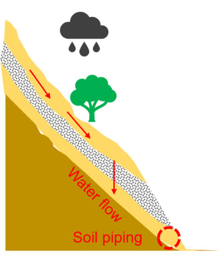
1. Introduction
2. Materials and Methods
2.1. Basic Material Properties
2.2. Water Flow and Slope Failure in Multi-Layer Slope Models
2.2.1. Flume Model System
2.2.2. Rainfall Simulation System
2.2.3. Theory of Measurement Devices
2.2.4. Testing Procedure
Soil Preparation
Compaction of Soils
Positions of Sensors and Cameras
3. Results
3.1. Failure Situations in All Cases
3.2. Profile of the Volumetric Water Content in a Slope
3.2.1. Beginning of Rainfall (t = 0 h)
3.2.2. The Breakthrough of the Capillary Barrier (Case I, II, and III)
3.2.3. Post-Breakthrough of the Capillary Barrier (t = 0.6–0.78 h in Case I, II, and III)
3.2.4. Failure Occurred (t = 0.78–1.2 h)
3.2.5. Capillary Barrier Restoration in the Drying Process (t = 3.5–36 h)
3.3. Influence of the Tilt Angle
3.3.1. Influence of the Tilt Angle on Water Movement
3.3.2. Influence of the Tilt Angle on the Pore Pressure and VWC
4. Discussion
4.1. Mechanism of the Capillary Barrier
4.2. D Flow and Multi-Layer Slope Stability
5. Conclusions
Author Contributions
Funding
Acknowledgments
Conflicts of Interest
References
- Santi, P.M. Debris-flow hazards and related phenomena: (Edited by matthias jakob and oldrich hungr). Environ. Eng. Geosci. 2007, 13, 75. [Google Scholar] [CrossRef]
- Sidle, R.C.; Ochiai, H. Landslides: Processes, prediction, and land use. In Water Resources Monograph; American Geophysical Union: Washington, DC, USA, 2006. [Google Scholar]
- Mancarella, D.; Simeone, V. Capillary barrier effects in unsaturated layered soils, with special reference to the pyroclastic veneer of the Pizzo d’Alvano, Campania, Italy. Bull. Eng. Geol. Environ. 2012, 71, 791–801. [Google Scholar] [CrossRef]
- Webb, R.W.; Fassnacht, S.R.; Gooseff, M.N.; Webb, S.W. The presence of hydraulic barriers in layered snowpacks: TOUGH2 simulations and estimated diversion lengths. Transp. Porous Media 2018, 123, 457–476. [Google Scholar] [CrossRef]
- Khire, M.V.; Benson, C.H.; Bosscher, P.J. Capillary Barriers: Design Variables and Water Balance. J. Geotech. Geoenviron. Eng. 2000, 126, 695–708. [Google Scholar] [CrossRef]
- Abdolahzadeh, A.M.; Vachon, B.L.; Cabral, A.R. Evaluation of the effectiveness of a cover with capillary barrier effect to control percolation into a waste disposal facility. Can. Geotech. J. 2011, 48, 996–1009. [Google Scholar] [CrossRef]
- Rahardjo, H.; Santoso, V.A.; Leong, E.C.; Ng, Y.S.; Tam, C.P.H.; Satyanaga, A. Use of recycled crushed concrete and Secudrain in capillary barriers for slope stabilization. Can. Geotech. J. 2013, 50, 662–673. [Google Scholar] [CrossRef]
- Garcia, E.F.; Gallage, C.P.K.; Uchimura, T. Function of permeable geosynthetics in unsaturated embankments subjected to rainfall infiltration. Geosynth. Int. 2007, 14, 89–99. [Google Scholar] [CrossRef]
- Morel-Seytoux, H.J.; Nimmo, J.R. Soil water retention and maximum capillary drive from saturation to oven dryness. Water Resour. Res. 1999, 35, 2031–2041. [Google Scholar] [CrossRef]
- Kämpf, M.; Holfelder, T.; Montenegro, H. Identification and parameterization of flow processes in artificial capillary barriers. Water Resour. Res. 2003, 39, 1–9. [Google Scholar] [CrossRef]
- Rulon, J.J.; Freeze, R.A. Multiple seepage faces on layered slopes and their implications for slope-stability analysis. Can. Geotech. J. 1985, 22, 347–356. [Google Scholar] [CrossRef]
- Hideki, I. Relationship between slope failure and the active fault based on kumamoto earthquake in 2016 and following heavy rainfall induced disaster. J. Jpn. Soc. Eng. Geol. 2017, 58, 188–196. [Google Scholar]
- Matsushi, Y.; Hattanji, T.; Matsukura, Y. Mechanisms of shallow landslides on soil-mantled hillslopes with permeable and impermeable bedrocks in the Boso Peninsula, Japan. Geomorphology 2006, 76, 92–108. [Google Scholar] [CrossRef]
- Hamrouni, F.; Trabelsi, H.; Jamei, M.; Olivella, S. Numerical analysis of landslides caused by rainfall in a reduced physical slope model. Eur. J. Environ. Civ. Eng. 2019, 0, 1–22. [Google Scholar] [CrossRef]
- Hillel, D. Environmental Soil Physics: Fundamentals, Applications, and Environmental Considerations; Elsevier: Amsterdam, The Netherlands, 1998; ISBN 0080544150. [Google Scholar]
- Wang, C.; Mao, X.; Hatano, R. Modeling ponded infiltration in fine textured soils with coarse interlayer. Soil Sci. Soc. Am. J. 2014, 78, 745–753. [Google Scholar] [CrossRef]
- Yang, H.; Rahardjo, H.; Leong, E.C.; Fredlund, D.G. A study of infiltration on three sand capillary barriers. Can. Geotech. J. 2004, 41, 629–643. [Google Scholar] [CrossRef]
- Mancarella, D.; Doglioni, A.; Simeone, V. On capillary barrier effects and debris slide triggering in unsaturated layered covers. Eng. Geol. 2012, 147–148, 14–27. [Google Scholar] [CrossRef]
- Damiano, E.; Greco, R.; Guida, A.; Olivares, L.; Picarelli, L. Investigation on rainwater infiltration into layered shallow covers in pyroclastic soils and its effect on slope stability. Eng. Geol. 2017, 220, 208–218. [Google Scholar] [CrossRef]
- Hillel, D. Introduction to Soil Physics; Academic Press: Cambridge, MA, USA, 1982. [Google Scholar]
- Van Genuchten, M.T. A closed-form equation for predicting the hydraulic conductivity of unsaturated soils1. Soil Sci. Soc. Am. J. 1980, 44, 892–898. [Google Scholar] [CrossRef]
- Evett, S.R.; Tolk, J.A.; Howell, T.A. Soil profile water content determination: Sensor accuracy, axial response, calibration, temperature dependence, and precision. Vadose Zone J. 2006, 5, 894–907. [Google Scholar] [CrossRef]
- Di Matteo, L.; Pauselli, C.; Valigi, D.; Ercoli, M.; Rossi, M.; Guerra, G.; Cambi, C.; Ricco, R.; Vinti, G. Reliability of water content estimation by profile probe and its effect on slope stability. Landslides 2018, 15, 173–180. [Google Scholar] [CrossRef]
- Zhan, L.T.; Li, G.Y.; Jiao, W.G.; Wu, T.; Lan, J.W.; Chen, Y.M. Field measurements of water storage capacity in a loess-gravel capillary barrier cover using rainfall simulation tests. Can. Geotech. J. 2017, 54, 1523–1536. [Google Scholar] [CrossRef]
- Sinai, G.; Zaslavsky, D.; Golany, P. The effect of soil surface curvature on moisture and yield—Beer sheba observation. Soil Sci. 1981, 132, 367–375. [Google Scholar] [CrossRef]
- Yeh, W.W.-G. Reservoir Management and operations models: A state-of-the-art review. Water Resour. Res. 1985, 21, 1797–1818. [Google Scholar] [CrossRef]
- Xie, J.; Uchimura, T.; Chen, P.; Liu, J.; Xie, C.; Shen, Q. A relationship between displacement and tilting angle of the slope surface in shallow landslides. Landslides 2019, 16, 1243–1251. [Google Scholar] [CrossRef]
- Junfeng, T.; Taro, U.; Shangning, T.; Dong, H.; Jiren, X. Water movement and deformation in unsaturated multi-layered slope under heavy rainfall. Int. J. Geomate 2020, 19, 174–181. [Google Scholar] [CrossRef]
- Morris, C.E.; John, C. Stormont parametric study of unsaturated drainage layers in a capillary barrier. J. Geotech. Geoenviron. Eng. 1999, 125, 1057–1065. [Google Scholar]
- Morris, C.E.; Stormont, J.C. Capillary barriers and subtitle D covers: Estimating equivalency. J. Environ. Eng. 1997, 123, 3–10. [Google Scholar] [CrossRef]
- Walter, M.T.; Kim, J.S.; Steenhuis, T.S.; Parlange, J.Y.; Heilig, A.; Braddock, R.D.; Selker, J.S.; Boll, J. Funneled flow mechanisms in a sloping layered soil: Laboratory investigation. Water Resour. Res. 2000, 36, 841–849. [Google Scholar] [CrossRef]
- Calcaterra, D.; Parise, M.; Palma, B.; Pelella, L. The influence of meteoric events in triggering shallow landslides in pyroclastic deposits of Campania, Italy. Hazards Mitig. 2000, 11, 99–107. [Google Scholar]
- Del Prete, M.; Guadagno, F.M.; Hawkins, A.B. Preliminary report on the landslides of 5 May 1998, Campania, southern Italy. Bull. Eng. Geol. Environ. 1998, 57, 113–129. [Google Scholar] [CrossRef]
- Hu, W.; Dong, X.J.; Xu, Q.; Wang, G.H.; van Asch, T.W.J.; Hicher, P.Y. Initiation processes for run-off generated debris flows in the Wenchuan earthquake area of China. Geomorphology 2016, 253, 468–477. [Google Scholar] [CrossRef]
- Wang, G.; Sassa, K. Factors affecting rainfall-induced flowslides in laboratory flume tests. Géotechnique 2001, 51, 587–599. [Google Scholar] [CrossRef]
- Hu, W.; Scaringi, G.; Xu, Q.; Huang, R. Internal erosion controls failure and runout of loose granular deposits: Evidence from flume tests and implications for postseismic slope healing. Geophys. Res. Lett. 2018, 45, 5518–5527. [Google Scholar] [CrossRef]
- Hu, W.; Scaringi, G.; Xu, Q.; Pei, Z.; Van Asch, T.W.J.; Hicher, P.Y. Sensitivity of the initiation and runout of flowslides in loose granular deposits to the content of small particles: An insight from flume tests. Eng. Geol. 2017, 231, 34–44. [Google Scholar] [CrossRef]
- Huang, A.B.; Lee, J.T.; Ho, Y.T.; Chiu, Y.F.; Cheng, S.Y. Stability monitoring of rainfall-induced deep landslides through pore pressure profile measurements. Soils Found. 2012, 52, 737–747. [Google Scholar] [CrossRef]
- Tao, S.; Uchimura, T.; Fukuhara, M.; Tang, J.; Chen, Y.; Huang, D. Evaluation of soil moisture and shear deformation based on compression wave velocities in a shallow slope surface layer. Sensors 2019, 19, 3406. [Google Scholar] [CrossRef]


| Description | Silica No 7 | Silica No 1 |
|---|---|---|
| Specific gravity Gs | 2.63 | 2.62 |
| Gravel content (>4.75 mm; %) | 0 | 97.13 |
| Sand content (%) | 87.31 | 2.86 |
| Fines content (<0.075 mm; %) | 11.64 | 0 |
| D10 (mm) | 0.043 | 2.26 |
| D50 (mm) | 0.152 | 3.52 |
| D60 (mm) | 0.165 | 4.21 |
| Maximum dry density (g/cm3) | 1.556 | 1.52 |
| Minimum dry density (g/cm3) | 1.271 | 1.3 |
| Description | Symbol (unit) | Soil | |
|---|---|---|---|
| No 7 | No 1 | ||
| Drying curve | |||
| Saturated volume water content | 0.44 | 0.42 | |
| Air-entry value | ψa (kPa) | 2.44 | 0.62 |
| Residual volume water content | 0.12 | 0.05 | |
| van Genuchten model | a | 0.41 | 1.59 |
| Fitting parameter | n | 4.07 | 3.11 |
| m | 1.42 | 0.67 | |
| Wetting curve | |||
| van Genuchten model | a | 0.42 | 0.03 |
| Fitting parameter | n | 4.51 | 1.42 |
| m | 0.78 | 0.29 | |
| Experiment | Sediment Type | No. of Layers | Tilt Angle (°) | Rainfall Intensity | Depth of Layers |
|---|---|---|---|---|---|
| Case I | S1, S7 | 3 | 0 | 75 mm/h | 0.2 m, 0.05 m, 0.2 m |
| Case II | S1, S7 | 3 | 7 | 75 mm/h | 0.2 m, 0.05 m, 0.2 m |
| Case III | S1, S7 | 3 | 15 | 75 mm/h | 0.2 m, 0.05 m, 0.2 m |
| Case IV | S1, S7 | 3 | 21 | 75 mm/h | 0.2 m, 0.05 m, 0.2 m |
| Case V | S7 | 1 | 0 | 75 mm/h | 0.45 m |
| Case VI | S7 | 1 | 7 | 75 mm/h | 0.45 m |
| Case VII | S7 | 1 | 15 | 75 mm/h | 0.45 m |
| Case VIII | S7 | 1 | 21 | 75 mm/h | 0.45 m |
| Experiment | Rainfall Intensity I | Tilt Angle α (°) | Failure Modes | Initial Failure Time t (h) |
|---|---|---|---|---|
| Case I | 75 mm/h | 0 | Piping slightly | 1.18 h |
| Case II | 75 mm/h | 7 | Piping | 0.84 h |
| Case III | 75 mm/h | 15 | Piping | 0.78 h |
| Case IV | 75 mm/h | 21 | Piping | 0.62 h |
| Case V | 75 mm/h | 0 | Surface slides | 0.95 h |
| Case VI | 75 mm/h | 7 | Surface slides | 0.89 h |
| Case VII | 75 mm/h | 15 | Surface slides | 0.85 h |
| Case VIII | 75 mm/h | 21 | Surface slides | 0.76 h |
© 2020 by the authors. Licensee MDPI, Basel, Switzerland. This article is an open access article distributed under the terms and conditions of the Creative Commons Attribution (CC BY) license (http://creativecommons.org/licenses/by/4.0/).
Share and Cite
Tang, J.; Taro, U.; Huang, D.; Xie, J.; Tao, S. Physical Model Experiments on Water Infiltration and Failure Modes in Multi-Layered Slopes under Heavy Rainfall. Appl. Sci. 2020, 10, 3458. https://doi.org/10.3390/app10103458
Tang J, Taro U, Huang D, Xie J, Tao S. Physical Model Experiments on Water Infiltration and Failure Modes in Multi-Layered Slopes under Heavy Rainfall. Applied Sciences. 2020; 10(10):3458. https://doi.org/10.3390/app10103458
Chicago/Turabian StyleTang, Junfeng, Uchimura Taro, Dong Huang, Jiren Xie, and Shangning Tao. 2020. "Physical Model Experiments on Water Infiltration and Failure Modes in Multi-Layered Slopes under Heavy Rainfall" Applied Sciences 10, no. 10: 3458. https://doi.org/10.3390/app10103458
APA StyleTang, J., Taro, U., Huang, D., Xie, J., & Tao, S. (2020). Physical Model Experiments on Water Infiltration and Failure Modes in Multi-Layered Slopes under Heavy Rainfall. Applied Sciences, 10(10), 3458. https://doi.org/10.3390/app10103458