Capitalizing on Cellular Technology—Opportunities and Challenges for Near Ground Weather Monitoring †


Abstract
1. Introduction
2. Materials and Methods
2.1. The Passive Approach
2.2. The Active Approach
2.3. Methods
3. Results
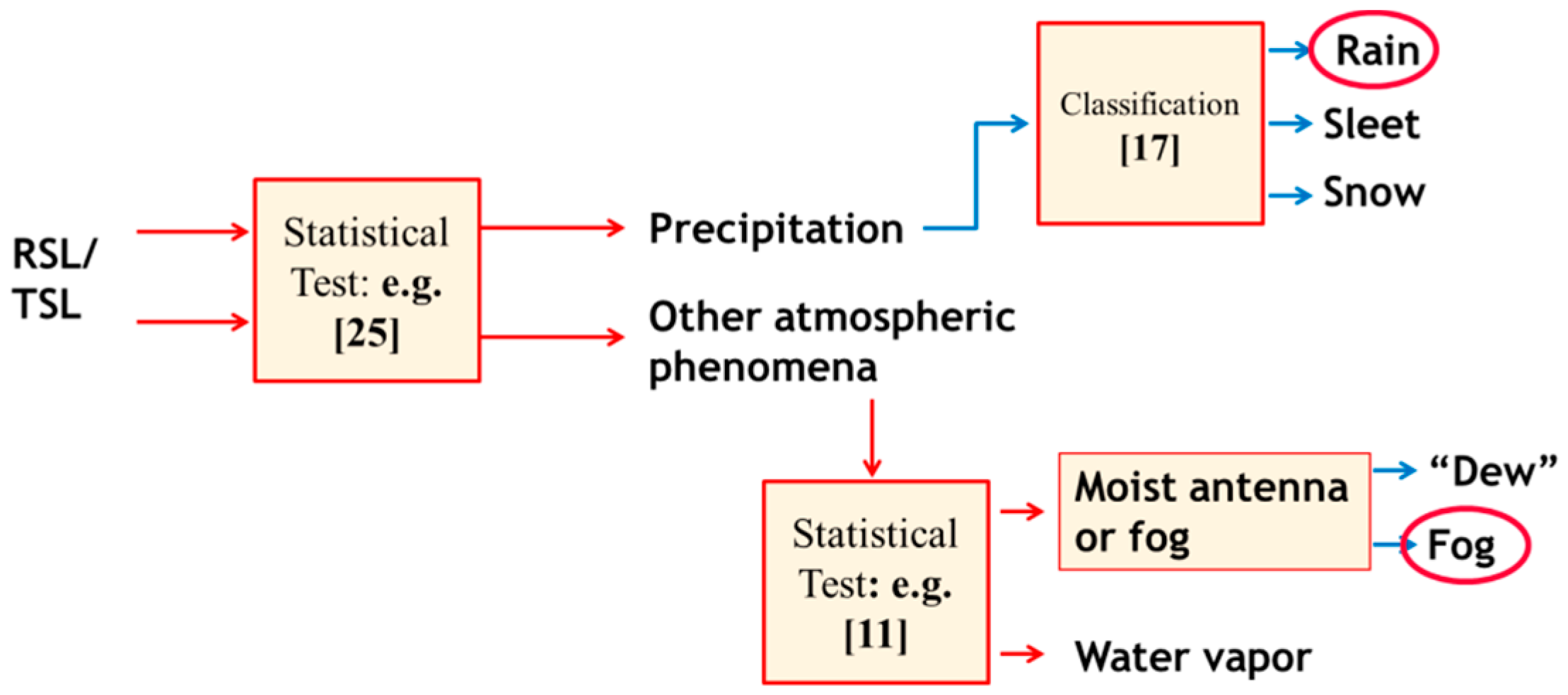
- Papers in which the capabilities of CML technology for environmental monitoring have been demonstrated (see Table 2). Naturally, foremost potential is attributed to the near-ground rainfall monitoring capability. Several papers demonstrated the CML as a rainfall sensor, and many CMLs as a sensors network, capable of 2D rainfall mapping. Later, other papers have demonstrated the use of CMLs for monitoring other-than-rain phenomena, including humidity, fog, dew, snow and sleet, and even wind and air pollution (indirectly).
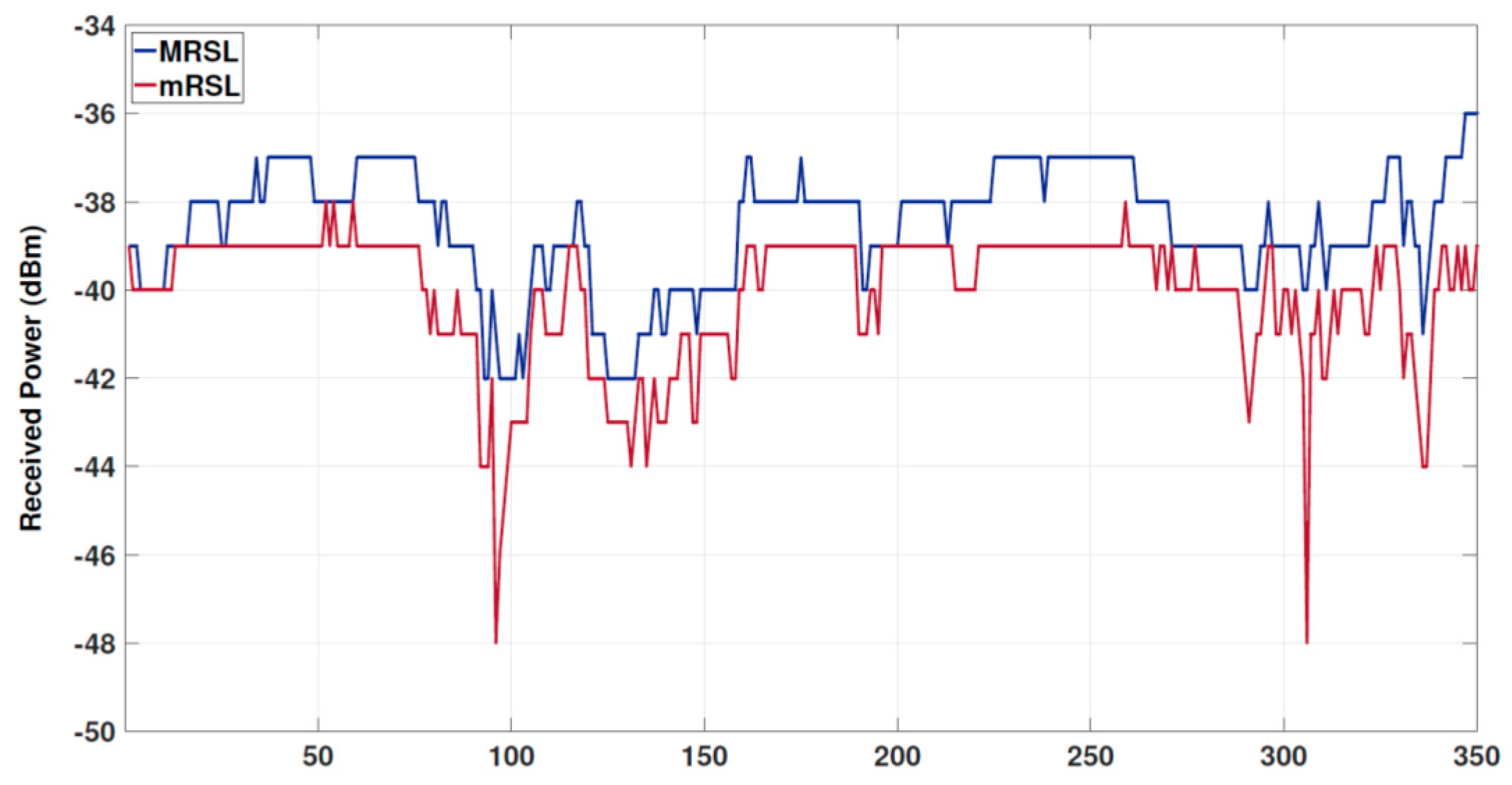
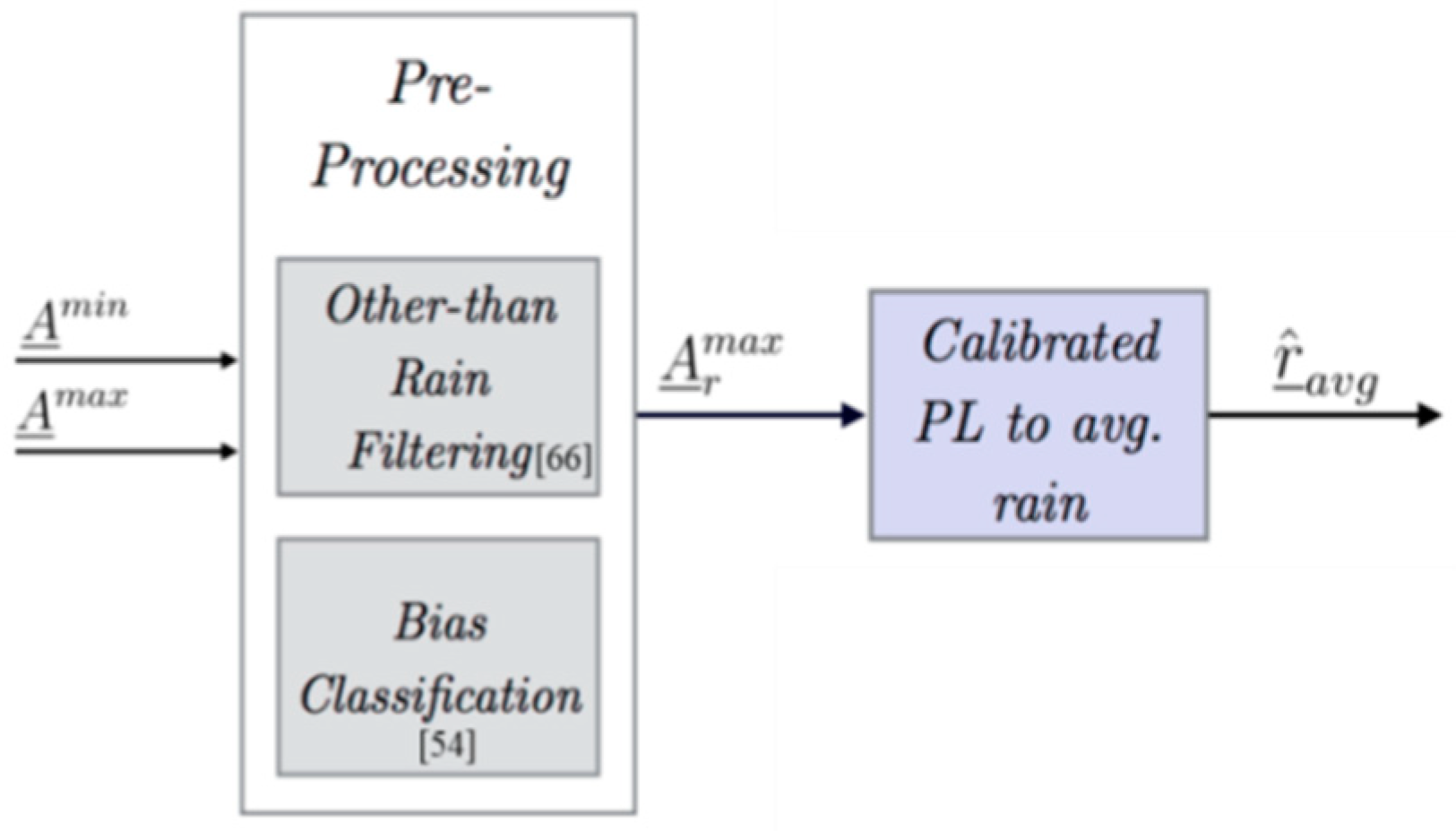
- The next step was to study the accuracy of CMLs as virtual rainfall sensors. Since cellular networks have been designed to operate optimally for efficient telecommunication service and not for measuring rain (or other atmospheric variables), its opportunistic use for rain monitoring is challenging, since the network must be taken as is. Table 3 presents a summary of the major contributions to an errors and uncertainties analysis. The analysis aims at quantifying the different sources’ errors and their effect on the resulting rain estimates. Generally speaking, the uncertainties can be put into two groups: one which is related to physical, atmospheric effects, e.g., wet antenna, which cause attenuation that may read as higher rain-intensity value in Equation (1) if not properly handled. The second group consists of errors caused by the opportunistic use of existing technology not aimed at atmospheric monitoring. This may include signal quantization and non-linear pre-processing (applied on the signal for efficient network management), as well as errors resulting from the non-optimal, given spatial spread of links and frequencies in the CML network, when being used for atmospheric monitoring.
- In Table 4, a list of papers suggesting algorithms for rainfall monitoring is presented. As the main opportunity in CML technology is in near ground, bottom-up rain mapping, most algorithms are focused on this. The straightforward approach is to treat each CML as a local point measurement and to interpolate local measurements to a grid, using standard spatial interpolation techniques (e.g., inverse distance weighting IDW, Kriging, etc.). On the basis of this approach, open software tools were developed [43,44]. More advanced algorithms have been developed by signal processing experts, on which the tempo-spatial resolution of the rainfall maps, their accuracy and their coverage have been improved by exploiting the spatial spread of the CML measurements. Different authors used different approaches, such as: an iterative approach in which variability of rain along the links is exploited [19]; a compressed sensing approach [45,46]; a model based, parametric approach; a tomographic approach [47]; and dynamic mapping [48,49]. The main future challenge is to improve CML rainfall maps by merging with other types of measurements (mostly radar), where these exist (see Reference [50] for a review of this issue).
- Table 5 details a partial list of applications. In all papers in this table, actual CML measurements were employed and empirical results were presented and validated over time, in different climatological areas.
4. Conclusions
4.1. The Commercialization Challenge
4.2. Potential Use
- Covering blind spots. There are areas where almost no near-ground measurements are available. One such example includes country-wide areas in developing countries, such as Africa [60,63]. Other examples are local, and include specific challenging landscapes such as slopes and urban areas, where traditional ground weather stations are known to be less reliable. Even with the limited accuracy of CML technology, in cases where there is no alternative, its potential is extremely important.
- Improving monitoring accuracy. Even in areas where the coverage of conventional weather-monitoring facilities (e.g., gauges and radar) is good, the use of additional ground-level measurements can improve performance. The potential improvement highly depends on the topology of the network (e.g., its density) and on the temporal resolution of the available measurements.
- Improving models. Complex meteorological and hydrological models, used for forecasting, are continuously improved by comparing their predictions to actual measurements. CML technology offers a new dimension of data to be assimilated in such models.
4.3. Limitations
4.4. A Test Case for Opportunistic Sensing of the Environment
Funding
Acknowledgments
Conflicts of Interest
References
- Atlas, D.; Ulbrich, C.W. Path-and area-integrated rainfall measurement by microwave attenuation in the 1–3 cm band. J. Appl. Meteorol. 1977, 16, 1322–1331. [Google Scholar] [CrossRef]
- Hogg, D.C. Millimeter-Wave Communication through the Atmosphere. Science 1968, 159, 39–46. [Google Scholar] [CrossRef] [PubMed]
- Olsen, R.O.G.E.R.S.; Rogers, D.V.; Hodge, D. The aRb relation in the calculation of rain attenuation. IEEE Trans. Antennas Propag. 1978, 26, 318–329. [Google Scholar] [CrossRef]
- Giuli, D.; Toccafondi, A.; Gentili, G.B.; Freni, A. Tomographic reconstruction of rainfall fields through microwave attenuation measurements. J. Appl. Meteorol. 1991, 30, 1323–1340. [Google Scholar] [CrossRef]
- Giuli, D.; Facheris, L.; Tanelli, S. Microwave tomographic inversion technique based on stochastic approach for rainfall fields monitoring. IEEE Trans. Geosci. Remote Sens. 1999, 37, 2536–2555. [Google Scholar] [CrossRef]
- Ruf, C.S.; Aydin, K.; Mathur, S.; Bobak, J.P. 35-GHz dual-polarization propagation link for rain-rate estimation. J. Atmos. Ocean. Technol. 1996, 13, 409–425. [Google Scholar] [CrossRef]
- D’Amico, M.; Pinotti, M.; Capsoni, C. The MANTISSA project: First results from the Italian field experiments. In Proceedings of the 2003 IEEE International Geoscience and Remote Sensing Symposium (IGARSS’03), Toulouse, France, 21–25 July 2003; Volume 7. [Google Scholar]
- Messer, H.; Zinevich, A.; Alpert, P. Environmental monitoring by wireless communication networks. Science 2006, 312, 713. [Google Scholar] [CrossRef] [PubMed]
- Rahimi, A.R.; Holt, A.R.; Upton, G.J.G.; Cummings, R.J. Use of dual-frequency microwave links for measuring path-averaged rainfall. J. Geophys. Res. Atmos. 2003, 108. [Google Scholar] [CrossRef]
- Zinevich, A.; Messer, H.; Alpert, P. Prediction of rainfall intensity measurement errors using commercial microwave communication links. Atmos. Meas. Tech. 2010, 3, 1385. [Google Scholar] [CrossRef]
- Ulaby, F.T.; Moore, R.K.; Fung, A.K. Microwave Remote Sensing: Acrive and Passive, Vol 1: Microwave Remote Sensing Fundamentals and Radiometry; Artech House Inc.: Norwood, MA, USA, 1981. [Google Scholar]
- Liebe, H.J.; Hufford, G.A.; Cotton, M.G. Propagation modeling of moist air and suspended water/ice particles below 1000 GHz. In Proceedings of the AGARD 52nd Specialists Meeting of Electromagnetic Wave Propagation Panel, Mallorca, Spain, 17–20 May 1993; pp. 3.1–3.10. [Google Scholar]
- International Telecommunication Union Recommendation. ITU-R P.530-17: Propagation Data and Prediction Methods Required for the Design of Terrestrial Line-of-Sight Systems; International Telecommunication Union Recommendation: Geneva, Switzerland, 2017. [Google Scholar]
- Messer, H.; Sendik, O. A new approach to precipitation monitoring: A critical survey of existing technologies and challenges. IEEE Signal Process. Mag. 2015, 32, 110–122. [Google Scholar] [CrossRef]
- Ostrometzky, J. Statistical Signal Processing of Extreme Attenuation Measurements Taken by Commercial Microwave Links for Rain Monitoring. Ph.D. Dissertation, Tel Aviv University, Tel Aviv, Israel, 2017. [Google Scholar]
- Fencl, M.; Rieckermann, J.; Sýkora, P.; Stránský, D.; Bareš, V. Commercial microwave links instead of rain gauges: Fiction or reality? Water Sci. Technol. 2015, 71, 31–37. [Google Scholar] [CrossRef] [PubMed]
- Matzler, C.; Koffi, E.; Berne, A. Monitoring rain rate with data from networks of microwave transmission links. In Proceedings of the 3rd European Conference on Antennas and Propagation (EuCAP 2009), Berlin, Germany, 23–27 March 2009; pp. 907–910. [Google Scholar]
- Leijnse, H.; Uijlenhoet, R.; Stricker, J.N.M. Rainfall measurement using radio links from cellular communication networks. Water Resour. Res. 2007, 43. [Google Scholar] [CrossRef]
- Messer, H.; Goldshtein, O.; Rayitsfeld, A.; Alpert, P. Recent results of rainfall mapping from cellular network measurements. In Proceedings of the IEEE International Conference on Acoustics, Speech and Signal Processing (ICASSP 2008), Las Vegas, NV, USA, 31 March–4 April 2008; pp. 5157–5160. [Google Scholar]
- David, N.; Alpert, P.; Messer, H. Novel method for water vapour monitoring using wireless communication networks measurements. Atmos. Chem. Phys. 2009, 9, 2413–2418. [Google Scholar] [CrossRef]
- David, N.; Sendik, O.; Messer, H.; Alpert, P. Cellular network infrastructure: The future of fog monitoring? Bull. Am. Meteorol. Soc. 2015, 96, 1687–1698. [Google Scholar] [CrossRef]
- David, N.; Alpert, P.; Messer, H. The potential of commercial microwave networks to monitor dense fog-feasibility study. J. Geophys. Res. Atmos. 2013, 118. [Google Scholar] [CrossRef]
- David, N.; Gao, H.O. Using Cell-Phone Tower Signals for Detecting the Precursors of Fog. J. Geophys. Res. Atmos. 2018, 123, 1325–1338. [Google Scholar] [CrossRef]
- Cherkassky, D.; Ostrometzky, J.; Messer, H. Precipitation classification using measurements from commercial microwave links. IEEE Trans. Geosci. Remote Sens. 2014, 52, 2350–2356. [Google Scholar] [CrossRef]
- Harel, O.; David, N.; Alpert, P.; Messer, H. The potential of microwave communication networks to detect dew—Experimental study. IEEE J. Sel. Top. Appl. Earth Obs. Remote Sens. 2015, 8, 4396–4404. [Google Scholar] [CrossRef]
- Messer, H.; Zinevich, A.; Alpert, P. Environmental sensor networks using existing wireless communication systems for rainfall and wind velocity measurements. IEEE Instrum. Meas. Mag. 2012, 15, 32–38. [Google Scholar] [CrossRef]
- David, N.; Gao, H.O. Using cellular communication networks to detect air pollution. Environ. Sci. Technol. 2016, 50, 9442–9451. [Google Scholar] [CrossRef] [PubMed]
- Gaona, R.M.F.; Overeem, A.; Leijnse, H.; Uijlenhoet, R. Measurement and interpolation uncertainties in rainfall maps from cellular communication networks. Hydrol. Earth Syst. Sci. 2015, 19, 3571–3584. [Google Scholar] [CrossRef]
- Leijnse, H.; Uijlenhoet, R.; Berne, A. Errors and uncertainties in microwave link rainfall estimation explored using drop size measurements and high-resolution radar data. J. Hydrometeorol. 2010, 11, 1330–1344. [Google Scholar] [CrossRef]
- Leijnse, H.; Uijlenhoet, R.; Stricker, J.N.M. Microwave link rainfall estimation: Effects of link length and frequency, temporal sampling, power resolution, and wet antenna attenuation. Adv. Water Resour. 2008, 31, 1481–1493. [Google Scholar] [CrossRef]
- Berne, A.; Uijlenhoet, R. Path-averaged rainfall estimation using microwave links: Uncertainty due to spatial rainfall variability. Geophys. Res. Lett. 2007, 34. [Google Scholar] [CrossRef]
- Harel, O.; Messer, H. Extension of the mflrt to detect an unknown deterministic signal using multiple sensors, applied for precipitation detection. IEEE Signal Process. Lett. 2013, 20, 945–948. [Google Scholar] [CrossRef]
- Wang, Z.; Schleiss, M.; Jaffrain, J.; Berne, A.; Rieckermann, J. Using Markov switching models to infer dry and rainy periods from telecommunication microwave link signals. Atmos. Meas. Tech. 2012, 5, 1847–1859. [Google Scholar] [CrossRef]
- Schleiss, M.; Berne, A. Identification of dry and rainy periods using telecommunication microwave links. IEEE Geosci. Remote Sens. Lett. 2010, 7, 611–615. [Google Scholar] [CrossRef]
- Ostrometzky, J.; Messer, H. Dynamic Determination of the Baseline Level in Microwave Links for Rain Monitoring from Minimum Attenuation Values. IEEE J. Sel. Top. Appl. Earth Obs. Remote Sens. 2018, 11, 24–33. [Google Scholar] [CrossRef]
- David, N.; Harel, O.; Alpert, P.; Messer, H. Study of attenuation due to wet antenna in microwave radio communication. In Proceedings of the 2016 IEEE International Conference on Acoustics, Speech and Signal Processing (ICASSP), Shanghai, China, 20–25 March 2016; pp. 4418–4422. [Google Scholar]
- Schleiss, M.; Rieckermann, J.; Berne, A. Quantification and modeling of wet-antenna attenuation for commercial microwave links. IEEE Geosci. Remote Sens. Lett. 2013, 10, 1195–1199. [Google Scholar] [CrossRef]
- Ostrometzky, J.; Raich, R.; Bao, L.; Hansryd, J.; Messer, H. The Wet-Antenna Effect—A Factor to be Considered in Future Communication Networks. IEEE Trans. Antennas Propag. 2018, 66, 315–322. [Google Scholar] [CrossRef]
- Ostrometzky, J.; Raich, R.; Eshel, A.; Messer, H. Calibration of the attenuation-rain rate power-law parameters using measurements from commercial microwave networks. In Proceedings of the 2016 IEEE International Conference on Acoustics, Speech and Signal Processing (ICASSP), Shanghai, China, 20–25 March 2016; pp. 3736–3740. [Google Scholar]
- Ostrometzky, J.; Eshel, A.; Alpert, P.; Messer, H. Induced bias in attenuation measurements taken from commercial microwave links. In Proceedings of the 2017 IEEE International Conference on Acoustics, Speech and Signal Processing (ICASSP), New Orleans, LA, USA, 5–9 March 2017; pp. 3744–3748. [Google Scholar]
- Ostrometzky, J.; Messer, H. Accumulated rainfall estimation using maximum attenuation of microwave radio signal. In Proceedings of the 2014 IEEE 8th Sensor Array and Multichannel Signal Processing Workshop (SAM), A Coruna, Spain, 22–25 June 2014; pp. 193–196. [Google Scholar]
- Gazit, L.; Messer, H. Sufficient Conditions for Reconstructing 2-D Rainfall Maps. IEEE Trans. Geosci. Remote Sens. 2018. [Google Scholar] [CrossRef]
- Overeem, A.; Leijnse, H.; Uijlenhoet, R. Retrieval algorithm for rainfall mapping from microwave links in a cellular communication network. Atmos. Meas. Tech. 2016, 9, 2425–2444. [Google Scholar] [CrossRef]
- Chwala, C.; Keis, F.; Kunstmann, H. Real-time data acquisition of commercial microwave link networks for hydrometeorological applications. Atmos. Meas. Tech. 2016, 9, 991–999. [Google Scholar] [CrossRef]
- Liberman, Y.; Messer, H. Accurate reconstruction of rain field maps from Commercial Microwave Networks using sparse field modeling. In Proceedings of the 2014 IEEE International Conference on Acoustics, Speech and Signal Processing (ICASSP), Florence, Italy, 4–9 May 2014; pp. 6786–6789. [Google Scholar]
- Roy, V.; Gishkori, S.; Leus, G. Spatial rainfall mapping from path-averaged rainfall measurements exploiting sparsity. In Proceedings of the 2014 IEEE Global Conference on Signal and Information Processing (GlobalSIP), Atlanta, GA, USA, 3–5 December 2014; pp. 321–325. [Google Scholar]
- D’Amico, M.; Manzoni, A.; Solazzi, G.L. Use of operational microwave link measurements for the tomographic reconstruction of 2-D maps of accumulated rainfall. IEEE Geosci. Remote Sens. Lett. 2016, 13, 1827–1831. [Google Scholar] [CrossRef]
- Roy, V.; Gishkori, S.; Leus, G. Dynamic rainfall monitoring using microwave links. EURASIP J. Adv. Signal Process. 2016, 2016. [Google Scholar] [CrossRef]
- Zinevich, A.; Messer, H.; Alpert, P. Frontal rainfall observation by a commercial microwave communication network. J. Appl. Meteorol. Climatol. 2009, 48, 1317–1334. [Google Scholar] [CrossRef]
- Messer, H. Multimodality for Rainfall Measurement. In Proceedings of the International Conference on Latent Variable Analysis and Signal Separation, Grenoble, France, 21–23 February 2017; Springer: Cham, Switzerland, 2017; pp. 333–343. [Google Scholar]
- Goldshtein, O.; Messer, H.; Zinevich, A. Rain rate estimation using measurements from commercial telecommunications links. IEEE Trans. Signal Process. 2009, 57, 1616–1625. [Google Scholar] [CrossRef]
- Zinevich, A.; Alpert, P.; Messer, H. Estimation of rainfall fields using commercial microwave communication networks of variable density. Adv. Water Resour. 2008, 31, 1470–1480. [Google Scholar] [CrossRef]
- Messer, H. Rainfall monitoring using cellular networks [in the spotlight]. IEEE Signal Process. Mag. 2007, 24, 142–144. [Google Scholar] [CrossRef]
- Haese, B.; Hörning, S.; Chwala, C.; Bárdossy, A.; Schalge, B.; Kunstmann, H. Stochastic Reconstruction and Interpolation of Precipitation Fields Using Combined Information of Commercial Microwave Links and Rain Gauges. Water Resour. Res. 2017, 53, 10740–10756. [Google Scholar] [CrossRef]
- Mercier, F.; Barthès, L.; Mallet, C. Estimation of finescale rainfall fields using broadcast TV satellite links and a 4DVAR assimilation method. J. Atmos. Ocean. Technol. 2015, 32, 1709–1728. [Google Scholar] [CrossRef]
- Abrajano, D.G.; Okada, M. Compressed sensing based detection of localized heavy rain using microwave network attenuation. In Proceedings of the 2013 7th European Conference on Antennas and Propagation (EuCAP), Gothenburg, Sweden, 8–12 April 2013; pp. 2383–2386. [Google Scholar]
- Liberman, Y.; Samuels, R.; Alpert, P.; Messer, H. New algorithm for integration between wireless microwave sensor network and radar for improved rainfall measurement and mapping. Atmos. Meas. Tech. 2014, 7, 3549–3563. [Google Scholar] [CrossRef]
- Bianchi, B.; Jan van Leeuwen, P.; Hogan, R.J.; Berne, A. A variational approach to retrieve rain rate by combining information from rain gauges, radars, and microwave links. J. Hydrometeorol. 2013, 14, 1897–1909. [Google Scholar] [CrossRef]
- Cuccoli, F.; Facheris, L.; Gori, S.; Baldini, L. Retrieving rainfall fields through 5 tomographic processing applied to radio base network signals. In Proceedings of the Remote Sensing for Agriculture, Ecosystems, and Hydrology XIII, Prague, Czech Republic, 19–22 September 2011. [Google Scholar]
- Ostrometzky, J.; Cherkassky, D.; Messer, H. Accumulated mixed precipitation estimation using measurements from multiple microwave links. Adv. Meteorol. 2015, 2015, 707646. [Google Scholar] [CrossRef]
- Overeem, A.; Leijnse, H.; Uijlenhoet, R. Two and a half years of country-wide rainfall maps using radio links from commercial cellular telecommunication networks. Water Resour. Res. 2016, 52, 8039–8065. [Google Scholar] [CrossRef]
- Overeem, A.; Leijnse, H.; Uijlenhoet, R. Country-wide rainfall maps from cellular communication networks. Proc. Natl. Acad. Sci. USA 2013, 110, 2741–2745. [Google Scholar] [CrossRef] [PubMed]
- Gosset, M.; Kunstmann, H.; Zougmore, F.; Cazenave, F.; Leijnse, H.; Uijlenhoet, R.; Chwala, C.; Keis, F.; Doumounia, A.; Boubacar, B.; et al. Improving rainfall measurement in gauge poor regions thanks to mobile telecommunication networks. Bull. Am. Meteorol. Soc. 2016, 97, ES49–ES51. [Google Scholar] [CrossRef]
- Doumounia, A.; Gosset, M.; Cazenave, F.; Kacou, M.; Zougmore, F. Rainfall monitoring based on microwave links from cellular telecommunication networks: First results from a West African test bed. Geophys. Res. Lett. 2014, 41, 6016–6022. [Google Scholar] [CrossRef]
- Rayitsfeld, A.; Samuels, R.; Zinevich, A.; Hadar, U.; Alpert, P. Comparison of two methodologies for long term rainfall monitoring using a commercial microwave communication system. Atmos. Res. 2012, 104, 119–127. [Google Scholar] [CrossRef]
- Chwala, C.; Kunstmann, H.; Hipp, S.; Siart, U.; Eibert, T. Precipitation observation using commercial microwave communication links. In Proceedings of the 2012 IEEE International Geoscience and Remote Sensing Symposium (IGARSS), Munich, Germany, 22–27 July 2012; pp. 2922–2925. [Google Scholar]
- Chwala, C.; Gmeiner, A.; Qiu, W.; Hipp, S.; Nienaber, D.; Siart, U.; Eibert, T.; Pohl, M.; Seltmann, J.; Fritz, J.; et al. Precipitation observation using microwave backhaul links in the alpine and pre-alpine region of Southern Germany. Hydrol. Earth Syst. Sci. 2012, 16, 2647–2661. [Google Scholar] [CrossRef]
- Overeem, A.A.R.T.; Leijnse, H.I.D.D.E.; Uijlenhoet, R.E.M.K.O. Quantitative precipitation estimation using commercial microwave links. In Proceedings of the Weather Radar and Hydrology, Exeter, UK, 18–21 April 2011; pp. 129–134. [Google Scholar]
- Ramos, B.; Cordero, M.; Hurtado, K.; Núñez, A.; D’Amico, M. Rain rate estimation using a microwave link in Guayaquil City. In Proceedings of the Ecuador Technical Chapters Meeting (ETCM), Salinas, Ecuador, 16–20 October 2017; pp. 1–6. [Google Scholar]
- David, N.; Alpert, P.; Messer, H. The potential of cellular network infrastructures for sudden rainfall monitoring in dry climate regions. Atmos. Res. 2013, 131, 13–21. [Google Scholar] [CrossRef]
- Gustilo, R.C. Design of Wireless Disaster Alarm System Using Microwave Links. J. Telecommun. Electron. Comput. Eng. JTEC 2018, 10, 103–108. [Google Scholar]
- Bianchi, B.; Rieckermann, J.; Berne, A. Quality control of rain gauge measurements using telecommunication microwave links. J. Hydrol. 2013, 492, 15–23. [Google Scholar] [CrossRef]
- Zhang, P.; Liu, X.; Li, Z.; Zhou, Z.; Song, K.; Yang, P. Attenuation Correction of Weather Radar Reflectivity with Arbitrary Oriented Microwave Link. Adv. Meteorol. 2017, 2017, 6124149. [Google Scholar] [CrossRef]
- Trömel, S.; Ziegert, M.; Ryzhkov, A.V.; Chwala, C.; Simmer, C. Using Microwave Backhaul Links to Optimize the Performance of Algorithms for Rainfall Estimation and Attenuation Correction. J. Atmos. Ocean. Technol. 2014, 31, 1748–1760. [Google Scholar] [CrossRef]
- Krämer, S.; Verworn, H.-R.; Redder, A. Improvement of X-band radar rainfall estimates using a microwave link. Atmos. Res. 2005, 77, 278–299. [Google Scholar] [CrossRef]
- Yang, X.; Liu, X.; Gao, T.; Yang, C.; Song, K. Regional Attenuation Correction of Weather Radar Using a Distributed Microwave-Links Network. Adv. Meteorol. 2017, 2017, 8621239. [Google Scholar] [CrossRef]
- Rahimi, A.R.; Holt, A.R.; Upton, G.J.; Krämer, S.; Redder, A.; Verworn, H. Attenuation Calibration of an X-Band Weather Radar Using a Microwave Link. J. Atmos. Ocean. Technol. 2006, 23, 395–405. [Google Scholar] [CrossRef]
- Fencl, M.; Rieckermann, J.; Schleiss, M.; Stránský, D.; Bareš, V. Assessing the potential of using telecommunication microwave links in urban drainage modelling. Water Sci. Technol. 2013, 68, 1810–1818. [Google Scholar] [CrossRef] [PubMed]
- Overeem, A.; Leijnse, H.; Uijlenhoet, R. Measuring urban rainfall using microwave links from commercial cellular communication networks. Water Resour. Res. 2011, 47. [Google Scholar] [CrossRef]
- Fenicia, F.; Pfister, L.; Kavetski, D.; Matgen, P.; Iffly, J.; Hoffmann, L.; Uijlenhoet, R. Microwave Links for Rainfall Estimation in an Urban Environment: Insights from an Experimental Setup in Luxembourg-City. J. Hydrol. 2012, 464, 69–78. [Google Scholar] [CrossRef]
- Zohidov, B.; Andrieu, H.; Servières, M.; Normand, N. Retrieval of rainfall fields in urban areas using attenuation measurements from mobile phone networks: A modeling feasibility study. Hydrol. Earth Syst. Sci. Discuss. 2016. [Google Scholar] [CrossRef]
- Upton, G.; Holt, A.; Cummings, R.; Rahimi, A.; Goddard, J. Microwave Links: The Future for Urban Rainfall Measurement? Atmos. Res. 2005, 77, 300–312. [Google Scholar] [CrossRef]
- Ericsson™: Microweather: The Surprising Future of Microwave Links in Weather Forecasting. Available online: https://www.ericsson.com/thinkingahead/the-networked-society-blog/2016/06/02/9373/ (accessed on 8 May 2018).
- Jeff, T. Rain forecasts go mobile. Analysis of wireless communications data could give accurate weather at street level. Nature 2017, 544, 146–147. [Google Scholar]
- Muller, C.L.; Chapman, L.; Johnston, S.; Kidd, C.; Illingworth, S.; Foody, G.; Overeem, A.; Leigh, R.R. Crowdsourcing for climate and atmospheric sciences: Current status and future potential. Int. J. Climatol. 2015, 35, 3185–3203. [Google Scholar] [CrossRef]
- McCabe, M.F.; Rodell, M.; Alsdorf, D.E.; Miralles, D.G.; Uijlenhoet, R.; Wagner, W.; Lucieer, A.; Houborg, R.; Verhoest, N.E.C.; Franz, T.E.; et al. The future of Earth observation in hydrology. Hydrol. Earth Syst. Sci. 2017, 21, 3879. [Google Scholar] [CrossRef]
- Uijlenhoet, R.; Overeem, A.; Leijnse, H. Opportunistic remote sensing of rainfall using microwave links from cellular communication networks. Wiley Interdiscip. Rev. Water 2018. [Google Scholar] [CrossRef]
- Tauro, F.; Selker, J.; van de Giesen, N.; Abrate, T.; Uijlenhoet, R.; Porfiri, M.; Manfreda, S.; Caylor, K.; Moramarco, T.; Benveniste, J.; et al. Measurements and Observations in the XXI century (MOXXI): Innovation and multi-disciplinarity to sense the hydrological cycle. Hydrol. Sci. J. 2018, 63, 169–196. [Google Scholar] [CrossRef]


| Characteristics | Passive | Active |
|---|---|---|
| Source of measurements | Existing records from network management systems (NMS) | Designated data collection system |
| Temporal resolution | Minutes-days Typical-15 min | Seconds-minutes Typical-10 s |
| Non-linear preprocessing | Typically min/max values over a given interval | Non |
| Quantization | Yes | Yes |
| Major advantage | Simple access, no risk for cellular operators | Real time |
| Major disadvantage | Not available in real time | Hard to get |
| Summary | Recommended for research purposes and for historic studies | Essential for real time applications |
| Atmospheric Phenomenon | Reference |
|---|---|
| Rainfall sensing | [8,16,17,18] |
| Rainfall mapping | [8,19] |
| Humidity sensing | [20] |
| Fog sensing | [21,22,23] |
| Precipitation classification | [24] |
| Dew detection | [25] |
| Wind estimation | [26] |
| Air pollution detection | [27] |
| Sources of Errors | Reference |
|---|---|
| General | [10,28,29,30,31] |
| Dry/Wet | [32,33,34,35] |
| Wet antenna | [36,37,38] |
| Calibration | [39] |
| Quantization bias | [40] |
| Non-linear preprocessing | [15,41] |
| Network topology | [42] |
| Focus of the Algorithm | Reference |
|---|---|
| Instantaneous rain mapping | [19,45,46,51,52,53,54] |
| Dynamic rain mapping | [48,49,55] |
| Heavy rain detection | [56] |
| Merging with other measurements | [50,57,58] |
| Rainfall tomography | [47,59] |
| Accumulated precipitation | [60] |
| Open software tools | [43,44] |
| Application | Reference (Year) | Area/Comments |
|---|---|---|
| Large scale rainfall estimation/mapping | [61,62] | Holland |
| Rainfall measurements | [63,64] | Africa |
| [65] | Israel | |
| [66,67] | Germany | |
| [68] | Holland | |
| [69] | Ecuador | |
| Flood prediction | [70] | Israel |
| Disaster alarm | [71] | |
| Calibration of other sensors | [72,73,74,75,76,77] | |
| Hydrology | [78,79,80,81,82] | Urban drainage |
© 2018 by the author. Licensee MDPI, Basel, Switzerland. This article is an open access article distributed under the terms and conditions of the Creative Commons Attribution (CC BY) license (http://creativecommons.org/licenses/by/4.0/).
Share and Cite
Messer, H. Capitalizing on Cellular Technology—Opportunities and Challenges for Near Ground Weather Monitoring. Environments 2018, 5, 73. https://doi.org/10.3390/environments5070073
Messer H. Capitalizing on Cellular Technology—Opportunities and Challenges for Near Ground Weather Monitoring. Environments. 2018; 5(7):73. https://doi.org/10.3390/environments5070073
Chicago/Turabian StyleMesser, Hagit. 2018. "Capitalizing on Cellular Technology—Opportunities and Challenges for Near Ground Weather Monitoring" Environments 5, no. 7: 73. https://doi.org/10.3390/environments5070073
APA StyleMesser, H. (2018). Capitalizing on Cellular Technology—Opportunities and Challenges for Near Ground Weather Monitoring. Environments, 5(7), 73. https://doi.org/10.3390/environments5070073