What Do Users Really Need? Participatory Development of Decision Support Tools for Environmental Management Based on Outcomes


Abstract
1. Introduction
- How can we develop decision-support tools that align better with adaptive management and outcomes-based approaches to environmental management: what are the key requirements of such a system?
- How can we make better use of well-established web-based and mobile devices and software for supporting environmental decisions?
- How can we involve key stakeholders like scientists, regulators and land managers to better understand these requirements?
2. Background
3. Case Study Background
4. Methods
4.1. Ethical Statement
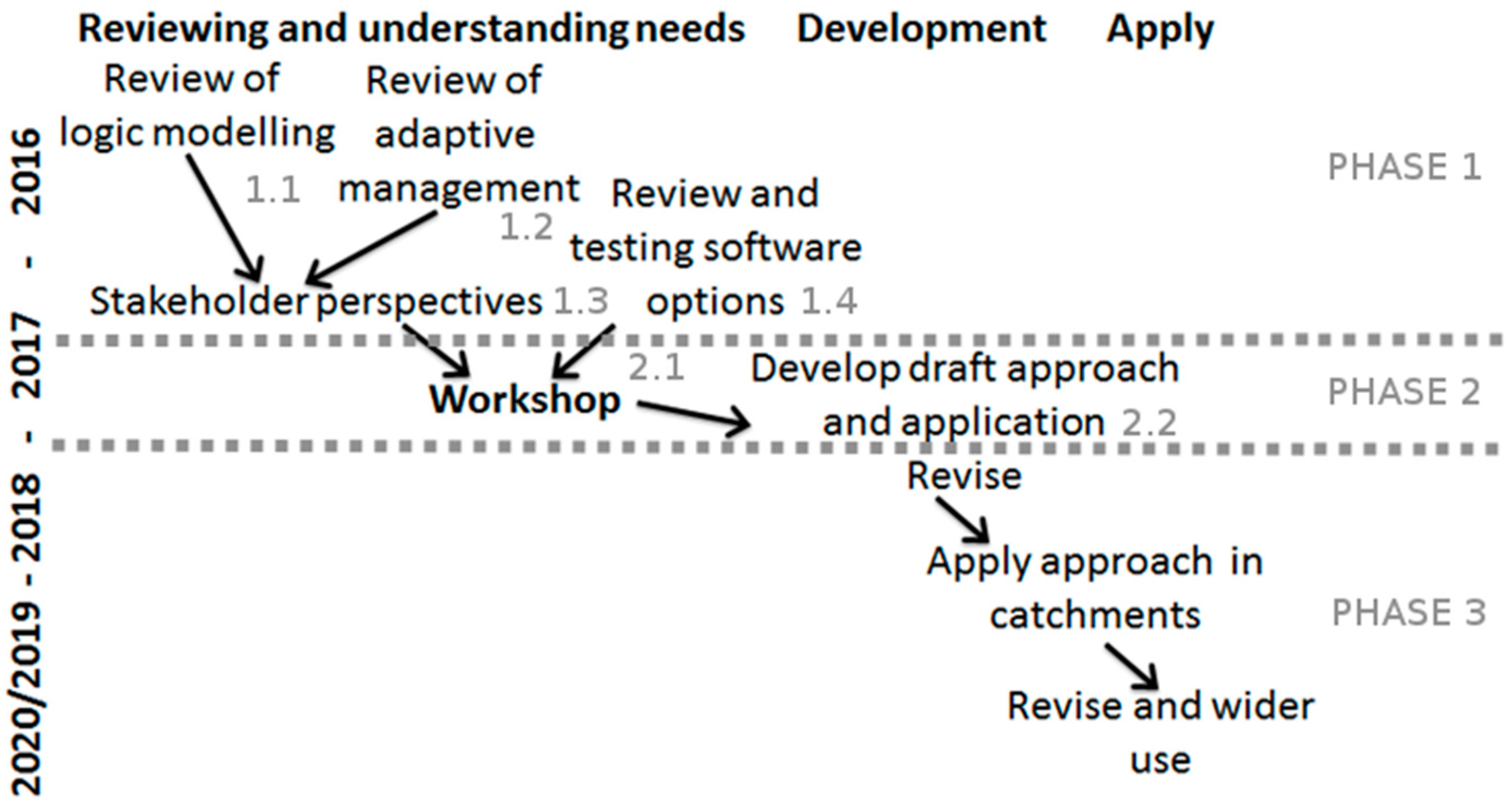
4.2. Phase 1: Stakeholder Engagement and Review of Software Options
4.3. Phase 2: Participatory Workshop
5. Results
5.1. Phase 1
- Should be free at the point of use. This is an essential pre-requisite of the outcomes-based approach, which requires transparency and effective exchange of knowledge and data between stakeholders at all points in the process chain. Commercially licensed software is typically not free to use or share and thus cannot meet this basic requirement.
- Should work on touch devices like mobile phones, tablets and larger touch tables. Touch-enabled devices are now very widely used, which is of itself an important reason why their use should be considered for EDSS. Touch user interfaces are popular because they facilitate user interaction, and, on larger devices, allow multiple stakeholders to interact at the same time. To ensure that any application can be widely shared, it should function on a range of devices, but without touch capability, the EDSS is restricted to ordinary PCs. At the same time, touch-enabled applications can easily be used with a keyboard and mouse if necessary, but standard applications frequently do not work on touch user interface devices. At present, many applications that have potential for use as EDSS (e.g., QGIS) are not designed for touch screen use, and we found that these tended to function poorly on touch devices. While a large touchtable is ideal for facilitating knowledge exchange between multiple participants (i.e., as in our workshop), outdoor workers, e.g., in forestry or agriculture, are likely to prefer an application which can run on portable devices like smartphones or tablets. In general, applications that are responsively designed to run on an ordinary smartphone may often be suitable for other devices as well.
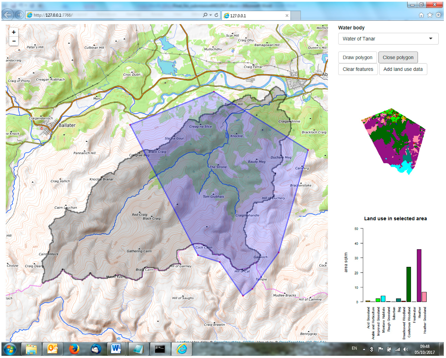
- Should have map-based functionality for users to interact with spatial information e.g., information on fields and other features related to land and water management. The focus on spatial information is crucial, since nearly all environmental decision-makers use maps as a means of communicating information about interventions in the landscape. At the same time, to establish a genuine process of knowledge exchange, information needs to flow in both directions, so some form of user interaction is necessary, either in terms of allowing the user to pull data from the system, or in actually offering the possibility to upload and work with users’ own data.
- Should include functionality for outcomes-based logic models i.e., linking land management to a range of outcomes. This apparently very specific requirement can be seen to have broader implications for environmental decision-support. The software needs to be able to link the information provided to the user to desirable or required outcomes in a dynamic way. In this way it is possible to understand the implications of different interventions—e.g., for example, by adding a connection between land use type in a holding and sediment or nutrient run-off, a user would potentially be able to evaluate the likely outcomes of land use changes in terms of water quality and other policy and management objectives.
- Should allow developers and end-users to develop and extend the software/existing application. The ability to modify and extend the software to add or change functionality was thought to be important, since environmental management is a dynamic sphere of action in which new datasets, plans and policies and strategies are frequently emerging. It should be clarified that we did not anticipate that all users should want or need to do this, but that it should in principle be possible for the development team.
- Should have potential for scientific innovation. This is a constraint that may have little interest from the point of view of an end-user, but is important for researchers in today’s competitive science environment. A tool or approach that cannot show some potential to advance scientific practice or understanding cannot be expected to hold the interest of the scientific community, and makes it more difficult to obtain funding. It should be emphasized that we are not necessarily talking about technological innovation—finding new ways for stakeholder groups to interact around a problem would also be a worthwhile scientific innovation.
- Should be actively maintained, preferably through a large, open user community. Given the previously mentioned interest in software that is free (at least at the point of use), it is important to distinguish between projects that are no longer actively maintained and those that are, preferable with a large or active user community. This is an important factor in ensuring the ability to modify or extend the software in the future—changes in PC hardware or software over time mean that software needs to be actively maintained. The multi-purpose software environment R and the popular free GIS package QGIS, for example, are actively maintained, with vibrant user communities, whereas the GIS software ILWIS, while still maintained, seems to be less actively developed and the user community, by comparison, is small.
5.1.1. Existing Adaptive Management Logic Model Applications
5.1.2. Existing Standalone Participatory Modelling Applications
5.1.3. GIS Modelling Applications
5.1.4. Software Packages and Applications for Developing Web-Based Applications
5.1.5. Summary of Findings from Software Survey
5.2. Phase 2
5.2.1. Stakeholders’ Principles for EDSS
- Updateability: This was regarded as very important due to the rapidly evolving nature of environmental policy and the need to be adaptable and responsive. Participants emphasized the highly changeable nature of both the policy context and the data (Principle 1 in Table 2).
- Practicability and usefulness: It was agreed that the tool should be both practical and useful. Since usefulness is subjective and therefore dependent on the end-user, involving end-users in the development process seemed like a good way to achieve this, e.g., through AGILE development principles [57] (Principle 2 in Table 2).
- Clarity of purpose and objectives: Participants highlighted the need for clarity about the intended purpose and objective of the application. This is likely to depend on specific end users, further highlighting the need for a flexible, AGILE-type approach (see above).
- Uncertainty, credibility and trustworthiness: Participants emphasized the need to deal honestly with uncertainty, both of data and of model/application outputs. This was regarded as having important implications for the credibility and trustworthiness of the information provided by the decision-support application (Principle 6 in Table 2). It was suggested that data should be filtered before providing it, since users may lack the knowledge to appreciate uncertainty. However, it was also appreciated that absolute certainty was not attainable, since scientists themselves frequently disagree about the trustworthiness of data or the reliability of the results. However, this was regarded as an important development principle even if it is not achievable in practice.
- Openness about limitations/transparency: It was regarded as important to be transparent about what a tool can and cannot do. Transparency of the tool and of the decision-making process was a key principle (Principle 6 in Table 2). This is somewhat related to the issue of trust and credibility (above).
- Specify intended scale of data and operation: In an issue related to the need for openness about uncertainty, participants raised the need to be clear about the intended cartographic scale of operation for the application. This can be partially addressed in practice by ensuring that datasets do not display at zoom levels that exceed their nominal scale.
- Cost-benefit estimates for policy interventions: The need to provide cost-benefit information was highlighted by one of the participants, but others disagreed. One argument that was made against this idea was that it would be difficult to determine which actors would be best placed to make the cost-benefit assessment, since each actor would require a different cost-benefit analysis to suit their land/circumstances.
- Diversity vs commonality: Although there was a high level of agreement about some aspects, for example, the importance of credibility (Principles 6 and 7 in Table 2) and accessibility (Principle 9 in Table 2), there was disagreement about others, e.g., appropriateness of cost-benefit analysis. This reminds us that end users are likely to have widely varying objectives in mind, and that it will be difficult to please all of them with a single application.
- Decision support, not decision automation: Participants were keen to emphasise the need to be clear that the tool supports decisions, but does not actually make them.
5.2.2. Facilitated Discussion around the Prototype Application
6. Discussion
Outcomes-Based Environmental Management: What Do Users Really Want?
- Problem-solving stage. The kinds of EDSS that help stakeholders understand complex interactions, explore future scenarios, or predict existing tendencies are generally not suitable, or really intended, for use directly by practitioners, but are rather intended to supply information to them in the form of reports and briefings based on model results. Generally, practitioners do not need or want to run land use simulations for 2050 or experiment with the effect of different types of forcing mechanisms on climate. An EDSS that a farmer might hold in their hand to allow them to explore a range of options for managing a river catchment belongs to a different part of the process at a later stage in the policy process. This kind of EDSS operates under the assumption that first type described is already embedded in the policy-making process. This type of EDSS belongs to a different problem-solving stage, where, in the words of [65], “we agree to stop worrying about generalities and focus instead on impacts, mitigation, compensation, and accommodation”. There is a fundamental need to better understand the requirements of users at the policy implementation stage.
- Type of decision-maker and level of action. A related question is the type of stakeholder to whom the EDSS is directed and the level of action at which they are typically operating. Water regulators with responsibility for large land areas, for example, may have advanced scientific training, and want to make use of integrated hydrological models like SWAT [66]. Local level actors, like municipal planners, conservation volunteers, or farmers, are unlikely to have such specific training and will have radically different questions they need to answer. The hypothetical farmer referred to above is making decisions at the scale of the land parcel, unlike, say, an agriculture minister, who is interested to know, in broader terms, about land use in general to inform land use policy more broadly. Many EDSS found in the scientific literature are concerned with these higher level or strategic decisions, while EDSS directed at the scale of the land parcel tend to be under-represented in the scientific literature (though see e.g., [10]). One of the most important priorities for our stakeholder group was the provision of reliable scientific information in an accessible and digestible format, rather than solution of complex analytical problems, or estimations of long-term tendencies.
- Technological development time-lag. The significant time lag between submitting research proposals and the award of funding, and between development of a model or system and publishing it in a journal means that the most recently published EDSS are based on conceptualizations of technology (if not actual availability) from three or four years ago. Given the pace of change in information systems development, there is a significant likelihood that EDSS of the kind that emerged from our participatory process are currently being developed but are poorly represented in literature. An interesting review of this topic in the context of rural development can be found in [67].
- Change in the role of the scientist. As can be appreciated from Table 4, the type of EDSS conceptualized on the right requires the scientist to play a different, perhaps less glamorous role, than that of aloof, objective expert of popular imagination. To help achieve sustainability objectives in land and water management scientific stakeholders should focus on facilitation and knowledge transfer at the level of implementation of concrete actions, as well as knowledge production activities higher up the chain.
7. Conclusions
Acknowledgments
Author Contributions
Conflicts of Interest
References
- Kok, K.; van Delden, H. Combining two approaches of integrated scenario development to combat desertification in the Guadalentin watershed, Spain. Environ. Plan. B Plan. Des. 2009, 36, 49–66. [Google Scholar] [CrossRef]
- McIntosh, B.S.; Ascough, J.C.; Twery, M.; Chew, J.; Elmahdi, A.; Haase, D.; Harou, J.J.; Hepting, D.; Cuddy, S.; Jakeman, A.J.; et al. Environmental decision support systems (EDSS) development—Challenges and best practices. Environ. Model. Softw. 2011, 26, 1389–1402. [Google Scholar] [CrossRef]
- Holmes, J.; Clark, R. Enhancing the use of science in environmental policy-making and regulation. Environ. Sci. Policy 2008, 11, 702–711. [Google Scholar] [CrossRef]
- Winder, N. Successes and problems when conducting interdisciplinary or transdisciplinary (= integrative) research. In Interdisciplinarity and Transdisciplinarity in Landscape Studies: Potential and Limitations; Delta Program: Wageningen, The Netherlands, 2003; pp. 74–90. [Google Scholar]
- Macleod, C.K.; Blackstock, K.; Haygarth, P. Mechanisms to improve integrative research at the science-policy interface for sustainable catchment management. Ecol. Soc. 2008, 13, 48. [Google Scholar] [CrossRef]
- Allen, C.R.; Fontaine, J.J.; Pope, K.L.; Garmestani, A.S. Adaptive management for a turbulent future. J. Environ. Manag. 2011, 92, 1339–1345. [Google Scholar] [CrossRef] [PubMed]
- Allan, C.; Stankey, G.H. Adaptive Environmental Management; Springer the Netherlands: Dordrecht, The Netherlands, 2009. [Google Scholar]
- Rosenhead, J.; Mingers, J. Rational Analysis for a Problematic World Revisited; John Wiley & Sons: Hoboken, NJ, USA, 2001. [Google Scholar]
- Shim, J.P.; Warkentin, M.; Courtney, J.F.; Power, D.J.; Sharda, R.; Carlsson, C. Past, present, and future of decision support technology. Decis. Support Syst. 2002, 33, 111–126. [Google Scholar] [CrossRef]
- Sharifi, M.A.; van Keulen, H. A decision support system for land use planning at farm enterprise level. Agric. Syst. 1994, 45, 239–257. [Google Scholar] [CrossRef]
- Matthews, K.B.; Sibbald, A.R.; Craw, S. Implementation of a spatial decision support system for rural land use planning: Integrating geographic information system and environmental models with search and optimisation algorithms. Comput. Electron. Agric. 1999, 23, 9–26. [Google Scholar] [CrossRef]
- Theobald, D.M.; Hobbs, N.T.; Bearly, T.; Zack, J.A.; Shenk, T.; Riebsame, W.E. Incorporating biological information in local land-use decision making: Designing a system for conservation planning. Landsc. Ecol. 2000, 15, 35–45. [Google Scholar] [CrossRef]
- Holling, C.S. Adaptive Environmental Assessment and Management; John Wiley & Sons: Hoboken, NJ, USA, 1978. [Google Scholar]
- Simon, H. The New Science of Management Decision; Harper Brothers: New York, NY, USA, 1960. [Google Scholar]
- Gorry, G.A.; Scott Morton, M.S. A Framework for Management Information Systems. 1971. Available online: https://dspace.mit.edu/bitstream/handle/1721.1/47936/frameworkformana00gorr.pdf (accessed on 5 October 2017).
- Engelen, G.; White, R.; Uljee, I.; Drazan, P. Using cellular automata for integrated modelling of socio-environmental systems. Environ. Monit. Assess. 1995, 34, 203–214. [Google Scholar] [CrossRef] [PubMed]
- Engelen, G.; Uljee, I.; White, R. Vulnerability Assessment of Low-lying Coastal Areas and Small Islands to Climate Change and Seal Level Rise—Phase 2: Case Study St. Lucia. 1997. Available online: http://www.dpi.inpe.br/cursos/tutoriais/modelagem/software_demos/simlucia/SimLuciaManual.pdf (accessed on 5 October 2017).
- Winograd, M.; Pérez-Soba, M.; Verweij, P. QUICKScan: A Pragmatic Approach for Decision Support in Ecosystem Services Assessment and Management. In Handbook on the Economics of Ecosystem Services and Biodiversity; Edward Elgar Cheltenham: Cheltenham, UK, 2013. [Google Scholar]
- Flacke, J.; De Boer, C. An Interactive Planning Support Tool for Addressing Social Acceptance of Renewable Energy Projects in The Netherlands. ISPRS Int. J. Geoinf. 2017, 6, 313. [Google Scholar] [CrossRef]
- Voinov, A.; Bousquet, F. Modelling with stakeholders. Environ. Model. Softw. 2010, 25, 1268–1281. [Google Scholar] [CrossRef]
- Van den Belt, M. Mediated Modeling: A System Dynamics Approach to Environmental Consensus Building; Island Press: Washington, DC, USA, 2004. [Google Scholar]
- Barreteau, O.; Antona, M.; D’Aquino, P.; Aubert, S.; Boissau, S.; Bousquet, F.; Daré, W.; Etienne, M.; Le Page, C.; Mathevet, R.; et al. Our Companion Modelling Approach. 2003. Available online: http://jasss.soc.surrey.ac.uk/6/2/1.html (accessed on 31 March 2003).
- Reed, M.S.; Evely, A.C.; Cundill, G.; Fazey, I.; Glass, J.; Laing, A.; Newig, J.; Parrish, B.; Prell, C.; Raymond, C.; et al. What is social learning? Ecol. Soc. 2010, 15, r1. [Google Scholar] [CrossRef]
- Volk, M.; Lautenbach, S.; van Delden, H.; Newham, L.T.; Seppelt, R. How can we make progress with decision support systems in landscape and river basin management? Lessons learned from a comparative analysis of four different decision support systems. Environ. Manag. 2010, 46, 834–849. [Google Scholar] [CrossRef] [PubMed]
- Mackay, E.B.; Wilkinson, M.E.; Macleod, C.J.; Beven, K.; Percy, B.J.; Macklin, M.G.; Quinn, P.F.; Stutter, M.; Haygarth, P.M. Digital catchment observatories: A platform for engagement and knowledge exchange between catchment scientists, policy makers, and local communities. Water Resour. Res. 2015, 51, 4815–4822. [Google Scholar] [CrossRef]
- Borowski, I.; Hare, M.P. Exploring the gap between water managers and researchers: Difficulties of model-based tools to support practical water management. Water Resour. Manag. 2007, 21, 1049–1074. [Google Scholar] [CrossRef]
- Uran, O.; Janssen, R. Why are spatial decision support systems not used? Some experiences from the Netherlands. Comput. Environ. Urban Syst. 2003, 27, 511–526. [Google Scholar] [CrossRef]
- Bagstad, K.J.; Semmens, D.J.; Waage, S.; Winthrop, R. A comparative assessment of decision-support tools for ecosystem services quantification and valuation. Ecosyst. Serv. 2013, 5, 27–39. [Google Scholar] [CrossRef]
- Leffingwell, D.; Widrig, D. Managing Software Requirements: A Unified Approach; Addison-Wesley Professional: Boston, MA, USA, 2000. [Google Scholar]
- Norman, D.A.; Draper, S.W. User Centered System Design; Lawrence Erlbaum Associates: Hillsdale, NJ, USA, 1986. [Google Scholar]
- Gulliksen, J.; Göransson, B.; Boivie, I.; Blomkvist, S.; Persson, J.; Cajander, Å. Key principles for user-centred systems design. Behav. Inf. Technol. 2003, 22, 397–409. [Google Scholar] [CrossRef]
- Sørensen, C.G.; Fountas, S.; Nash, E.; Pesonen, L.; Bochtis, D.; Pedersen, S.M.; Basso, B.; Blackmore, S.B. Conceptual model of a future farm management information system. Comput. Electron. Agric. 2010, 72, 37–47. [Google Scholar] [CrossRef]
- Sørensen, C.G.; Pesonen, L.; Bochtis, D.D.; Vougioukas, S.G.; Suomi, P. Functional requirements for a future farm management information system. Comput. Electron. Agric. 2011, 76, 266–276. [Google Scholar] [CrossRef]
- Kaloxylos, A.; Groumas, A.; Sarris, V.; Katsikas, L.; Magdalinos, P.; Antoniou, E.; Politopoulou, Z.; Wolfert, S.; Brewster, C.; Eigenmann, R.; et al. A cloud-based Farm Management System: Architecture and implementation. Comput. Electron. Agric. 2014, 100, 168–179. [Google Scholar] [CrossRef]
- Hewitt, R.; Van Delden, H.; Escobar, F. Participatory land use modelling, pathways to an integrated approach. Environ. Model. Softw. 2014, 52, 149–165. [Google Scholar] [CrossRef]
- Margoluis, R.; Stem, C.; Swaminathan, V.; Brown, M.; Johnson, A.; Placci, G.; Salafsky, N.; Tilders, I. Results chains: A tool for conservation action design, management, and evaluation. Ecol. Soc. 2013, 18, 22. [Google Scholar] [CrossRef]
- Macleod, C.J.A. How Can Logic Modelling Improve the Planning, Monitoring and Evaluation of Policy Measures and Wider Interventions for Multiple Benefits? 2016. Available online: http://www.hutton.ac.uk/sites/default/files/files/RESAS124_O3_D3_1_v0_5Final.pdf (accessed on 5 October 2017).
- Funnell, S.C.; Rogers, P.J. Purposeful Program Theory: Effective Use of Theories of Change and Logic Models; John Wiley & Sons: Hoboken, NJ, USA, 2011. [Google Scholar]
- Treasury, H.M. The Magenta Book: Guidance for Evaluation. 2011. Available online: https://www.gov.uk/government/uploads/system/uploads/attachment_data/file/220542/magenta_book_combined.pdf (accessed on 5 October 2017).
- Scottish Government. Getting the Best from Our Land. A Land Use Strategy for Scotland 2016–2021. 2016. Available online: http://www.gov.scot/Resource/0050/00505253.pdf (accessed on 22 March 2016).
- Scottish Government. Scottish Budget Spending Review 2007. Chapter 8: A National Performance Framework. 2007. Available online: http://www.gov.scot/Publications/2007/11/13092240/9 (accessed on 5 October 2017).
- Pahl-Wostl, C. A conceptual framework for analysing adaptive capacity and multi-level learning processes in resource governance regimes. Glob. Environ. Chang. 2009, 19, 354–365. [Google Scholar] [CrossRef]
- Scottish Government. Rural Payments and Services: Management Options and Capital Items. 2017. Available online: https://www.ruralpayments.org/publicsite/futures/topics/all-schemes/agri-environment-climate-scheme/management-options-and-capital-items/#32412 (accessed on 27 January 2017).
- Macleod, C.J.A.; Blackstock, K.; Brown, K.; Eastwood, A.; Gimona, A.; Prager, K.; Irvine, J. Adaptive Management: An Overview of the Concept and Its Practical Application in the Scottish Context. 2016. Available online: http://www.hutton.ac.uk/sites/default/files/files/research/srp2016-21/RESAS_srp143_aD1_ReportOnRelevantAdaptiveManagementApproachesForScotland_v0.8Final.pdf (accessed on 5 October 2017).
- Macleod, C.J.A.; Hewitt, R.J. Summary of research on developing a more integrated approach to land and water management using incentives and regulations for the delivery of multiple benefits: Exploring national and regional level stakeholder views and needs. Unpublished work. 2017. [Google Scholar]
- Gould, J.D.; Lewis, C. Designing for usability: Key principles and what designers think. Commun. ACM 1985, 28, 300–311. [Google Scholar] [CrossRef]
- Ball, J. Towards a methodology for mapping ‘regions for sustainability’ using PPGIS. Prog. Plan. 2002, 58, 81–140. [Google Scholar] [CrossRef]
- Macleod, C.J.A.; Hewitt, R. Workshop Summary: Developing an Outcome-Based Approach for Understanding the Effectiveness of Interventions in Catchments for Multiple Benefits. Unpublished work. 2017. [Google Scholar]
- InVEST. Nutrient Delivery Ratio Model. Available online: http://data.naturalcapitalproject.org/nightly-build/invest-users-guide/html/ndr.html (accessed on 5 October 2017).
- Voinov, A.; Kolagani, N.; McCall, M.K.; Glynn, P.D.; Kragt, M.E.; Ostermann, F.O.; Pierce, S.A.; Ramu, P. Modelling with stakeholders—Next generation. Environ. Model. Softw. 2016, 77, 196–220. [Google Scholar] [CrossRef]
- Basco-Carrera, L.; Warren, A.; van Beek, E.; Jonoski, A.; Giardino, A. Collaborative modelling or participatory modelling? A framework for water resources management. Environ. Model. Softw. 2017, 91, 95–110. [Google Scholar] [CrossRef]
- Dick, J.; Verweij, P.; Carmen, E.; Rodela, R.; Andrews, C. Testing the ecosystem service cascade framework and QUICKScan software tool in the context of land use planning in Glenlivet Estate Scotland. Int. J. Biodivers. Sci. Ecosyst. Serv. Manag. 2017, 13, 12–25. [Google Scholar] [CrossRef]
- Volkery, A.; Ribeiro, T.; Henrichs, T.; Hoogeveen, Y. Your vision or my model? Lessons from participatory land use scenario development on a European scale. Syst. Pract. Action Res. 2008, 21, 459–477. [Google Scholar] [CrossRef]
- Graymore, M.L.; Wallis, A.M.; Richards, A.J. An Index of Regional Sustainability: A GIS-based multiple criteria analysis decision support system for progressing sustainability. Ecol. Complex. 2009, 6, 453–462. [Google Scholar] [CrossRef]
- Novaczek, I.; MacFadyen, J.; Bardati, D.; MacEachern, K. Social and Cultural Values Mapping as a Decision-Support Tool for Climate Change Adaptation; The Institute of Island Studies, University of Prince Edward Island: Charlottetown, PE, Canada, 2011. [Google Scholar]
- Wangdi, K.; Banwell, C.; Gatton, M.L.; Kelly, G.C.; Namgay, R.; Clements, A.C. Development and evaluation of a spatial decision support system for malaria elimination in Bhutan. Malar. J. 2016, 15, 180. [Google Scholar] [CrossRef] [PubMed]
- Cockburn, A. Agile Software Development; Addison-Wesley: Boston, MA, USA, 2002. [Google Scholar]
- Teoh, T. Running R and RStudio from an Android Mobile Phone or Tablet. Available online: http://tteoh.com/technology/2016/10/20/r-rstudio-mobile-android/ (accessed on 20 October 2016).
- Land Cover Map 2007. Available online: https://www.ceh.ac.uk/services/land-cover-map-2007 (accessed on 5 October 2017).
- Grêt-Regamey, A.; Sirén, E.; Brunner, S.H.; Weibel, B. Review of decision support tools to operationalize the ecosystem services concept. Ecosyst. Serv. 2017, 26, 306–315. [Google Scholar] [CrossRef]
- Allan, C.; Curtis, A. Nipped in the bud: Why regional scale adaptive management is not blooming. Environ. Manag. 2005, 36, 414–425. [Google Scholar] [CrossRef] [PubMed]
- Plummer, R.; Baird, J.; Dzyundzyak, A.; Armitage, D.; Bodin, Ö.; Schultz, L. Is Adaptive Co-management Delivering? Examining Relationships between Collaboration, Learning and Outcomes in UNESCO Biosphere Reserves. Ecol. Econ. 2017, 140, 79–88. [Google Scholar] [CrossRef]
- Baldwin, C.; Hamstead, M. Integrated Water Resource Planning: Achieving Sustainable Outcomes; Routledge: Abingdon, UK, 2014. [Google Scholar]
- Bradshaw, G.A.; Borchers, J.G. Uncertainty as Information: Narrowing the Science-Policy Gap. Conserv. Ecol. 2000, 4, 7. [Google Scholar] [CrossRef]
- Cartledge, K.; Dürrwächter, C.; Hernandez Jimenez, V.; Winder, N. Making sure you solve the right problem. Ecol. Soc. 2009, 14, r3. [Google Scholar] [CrossRef]
- Arnold, J.G.; Srinivasan, R.; Muttiah, R.S.; Williams, J.R. Large area hydrologic modeling and assessment part I: Model development. J. Am. Water Resour. Assoc. 1998, 34, 73–89. [Google Scholar] [CrossRef]
- Salemink, K.; Strijker, D.; Bosworth, G. Rural development in the digital age: A systematic literature review on unequal ICT availability, adoption, and use in rural areas. J. Rural Stud. 2017, 54, 360–371. [Google Scholar] [CrossRef]
- Cash, D.; Clark, W.C.; Alcock, F.; Dickson, N.M.; Eckley, N.; Jäger, J. Salience, Credibility, Legitimacy and Boundaries: Linking Research, Assessment and Decision Making. 2002. Available online: https://papers.ssrn.com/sol3/papers.cfm?abstract_id=372280 (accessed on 5 October 2017).


| Options | Criteria | Selected: Yes or No | Links | ||||||
|---|---|---|---|---|---|---|---|---|---|
| Free to Use 1 | Use on Touch Devices 2 | Interact Spatially 3 | Logic Model 4 | Develop/ Extend 5 | Innovation 6 | Status 7 | |||
| Existing adaptive management logic model applications | |||||||||
| Miradi | 100–999 | No | No | Yes | No | Low | Active | No | https://www.miradi.org/ |
| Mobile version | Maybe 8 | Yes | Maybe | Yes | Maybe | Maybe | Active | No | http://monitoringapp.net/ |
| Existing standalone participatory modelling applications | |||||||||
| Quickscan | 100–999 | No | Yes | Maybe | No | Low-med | Active | No | http://www.quickscan.pro/products |
| Metronamica | >10,000 | No | Yes | Maybe | No | Low-med | Active | No | http://www.metronamica.nl/ |
| Geodesign | 0 | Maybe | Yes | Maybe | Maybe | Med-high | Active | No | https://www.geodesignhub.com/ |
| GIS modelling applications | |||||||||
| Community Viz ArcMap plugin | 100–999 | No | Yes | No | Yes | Med | Active | No | http://placeways.com/communityviz/index.html |
| MCDA4ArcMap | 0 9 | Maybe | Yes | No | Yes | Med | Active | No | https://mcda4arcmap.codeplex.com/ |
| EMDS (US EPA) | 0 | Maybe | Yes | Maybe | Maybe | Low-med | Active | No | https://esenvironmental.com/projects_epa_emds.htm |
| Standard ArcMap | 100–999 | No | Yes | No | Yes | Low-med | Active | No | http://www.arcgis.com/ |
| Standard QGIS | 0 | Yes with plugin | Yes | Yes | Yes | Med | Active | No | http://www.qgis.org/en/site/ |
| ROAM (QGIS app) | 0 | Yes | Yes | Maybe | Yes | Med-high | Active | Yes | https://github.com/DMS-Aus/Roam |
| Software packages and applications for developing web-based applications | |||||||||
| Python back-end based Leaflet applications e.g., Django or Flask | 0 | Yes | Yes | Yes | Yes | High | Active | Yes | https://www.djangoproject.com/ http://flask.pocoo.org/ |
| Javascript back-end based Leaflet applications using Node | 0 | Yes | Yes | Yes | Yes | High | Active | Yes | https://nodejs.org/en/ |
| Kivy | 0 | No 10 | Yes | Yes | Yes | High | Active | No | https://kivy.org/#home |
| RShiny, RShinydashboard | 0 | Yes | Yes | Yes | Yes | High | Active | Yes | https://shiny.rstudio.com/ https://rstudio.github.io/shinydashboard/ |
| Jupyter dashboard | 0 | Maybe | Yes | Yes | Yes | High | Active | Yes | https://github.com/jupyter/dashboards |
| Tableau | 0 | Yes | Yes | Yes | Yes | Med-high | Active | Yes | https://www.tableau.com/ |
| Spotfire | 1000–9999 | Yes | Yes | Yes | Yes | Med-high | Active | No | http://spotfire.tibco.com/ |
| Plotly (Dash) | 0 | Yes | Yes | Yes | Yes | Med-high | Active | Yes | https://plot.ly/products/dash/ |
| No. | Principle | What Stakeholder Requirement Does This Relate to? | Which of the Seven Criteria Does This Relate to? |
|---|---|---|---|
| 1 | Updateability | None | 2. Work on touch-enabled devices 5. Allow users to develop and extend 6. Potential for scientific innovation 7. Actively maintained |
| 2 | Agile development. Multiple versions |
| 1. Free at the point of use.
5. Allow users to develop and extend 7. Actively maintained |
| 3 | Provides cost-benefits of options |
| 3. Map-based functionality for users to interact with spatial information
4. Include functionality for outcomes-based logic models i.e., linking land management to a range of outcomes |
| 4 | Clarity of objective: public interest, land manager, community |
| 3. Map-based functionality for users to interact with spatial information.
4. Include functionality for outcomes-based logic models i.e., linking land management to a range of outcomes |
| 5 | Iterative: exploration of multiple scenarios and consequences |
| 4. Should include functionality for outcomes-based logic models i.e., linking land management to a range of outcomes |
| 6 | Credible/transparent |
| 1. Free at the point of use.
2. Work on touch-enabled devices 3. Map-based functionality for users to interact with spatial information. |
| 7 | Credible and trustworthy |
| 4. Should include functionality for outcomes-based logic models i.e., linking land management to a range of outcomes |
| 8 | Practical—relates to users experience and needs |
| 3. Map-based functionality for users to interact with spatial information. 4. Include functionality for outcomes-based logic models i.e., linking land management to a range of outcomes |
| 9 | Accessible/easy to use |
| 1. Free at the point of use. 2. Work on touch-enabled devices 3. Map-based functionality for users to interact with spatial information. |
| 10 | Clear on operational scale |
| 3. Map-based functionality for users to interact with spatial information. |
| 11 | Dealing honestly with uncertainty: avoid large-scale uniformity of outcome, diversity manage via incentives/regulations |
| 4. Should include functionality for outcomes-based logic models i.e., linking land management to a range of outcomes
5. Allow users to develop and extend |
| 12 | Limited need for time-consuming tool. Must not take ages to develop |
| 2. Work on touch-enabled devices 3. Map-based functionality for users to interact with spatial information. 5. Allow users to develop and extend |
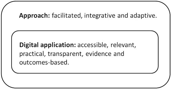
| Approach |
| The approach will help facilitate decisions about land and water resources. |
| It will aim to be integrative through considering a range of environmental and financial outcomes. |
| It will aim to support adaptive management though clarity of objectives/outcomes, and linking with evidence that supports exploration of those options to achieve those objectives/outcomes. |
| The approach will be designed to be easy to use and efficient. |
| Digital application |
| It will be accessible for anyone to use. |
| It will be relevant and practical for land managers. |
| It will aim to be credible, with transparency in the information and methods used. |
| It will be designed to be updateable with new information as it comes available. |
| EDSS that Scientists Have Tended to Develop | EDSS that Decision-Makers May Want |
|---|---|
| Platform | |
| Micro-computer oriented, Often Windows operating system only | Mobile device oriented (touchscreen), multi-platform |
| Cost model | |
| Proprietary | Free and Open-Source |
| Application type | |
| Stand-alone, out of the box solution that the user cannot easily modify | Flexible, integrated (web-based), easily customizable |
| Purpose | |
| Understanding a complex problem | Deciding from a range of options |
| Exploring future scenarios | Evaluating cost-benefit |
| Predicting tendencies | Linking science and policy to show clear outcomes |
| Synthesizing complex information into a digestible message | |
| Implicit role of scientist | |
| Selling knowledge systems | Facilitator and provider of free and open advice |
| External expert | Participant and stakeholder |
© 2017 by the authors. Licensee MDPI, Basel, Switzerland. This article is an open access article distributed under the terms and conditions of the Creative Commons Attribution (CC BY) license (http://creativecommons.org/licenses/by/4.0/).
Share and Cite
Hewitt, R.J.; Macleod, C.J.A. What Do Users Really Need? Participatory Development of Decision Support Tools for Environmental Management Based on Outcomes. Environments 2017, 4, 88. https://doi.org/10.3390/environments4040088
Hewitt RJ, Macleod CJA. What Do Users Really Need? Participatory Development of Decision Support Tools for Environmental Management Based on Outcomes. Environments. 2017; 4(4):88. https://doi.org/10.3390/environments4040088
Chicago/Turabian StyleHewitt, Richard J., and Christopher J. A. Macleod. 2017. "What Do Users Really Need? Participatory Development of Decision Support Tools for Environmental Management Based on Outcomes" Environments 4, no. 4: 88. https://doi.org/10.3390/environments4040088
APA StyleHewitt, R. J., & Macleod, C. J. A. (2017). What Do Users Really Need? Participatory Development of Decision Support Tools for Environmental Management Based on Outcomes. Environments, 4(4), 88. https://doi.org/10.3390/environments4040088