
Classification of Land Use on Sand-Dune Topography by Object-Based Analysis, Digital Photogrammetry, and GIS Analysis in the Horqin Sandy Land, China

Abstract
:
1. Introduction
2. Materials and Methods
2.1. Study Area
2.2. Data
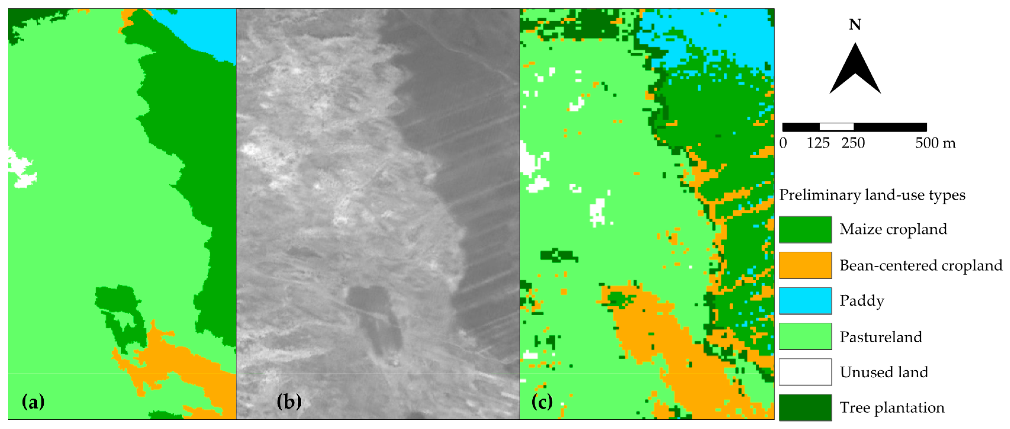
2.3. Object-Based Classification of Preliminary Land-Use Types
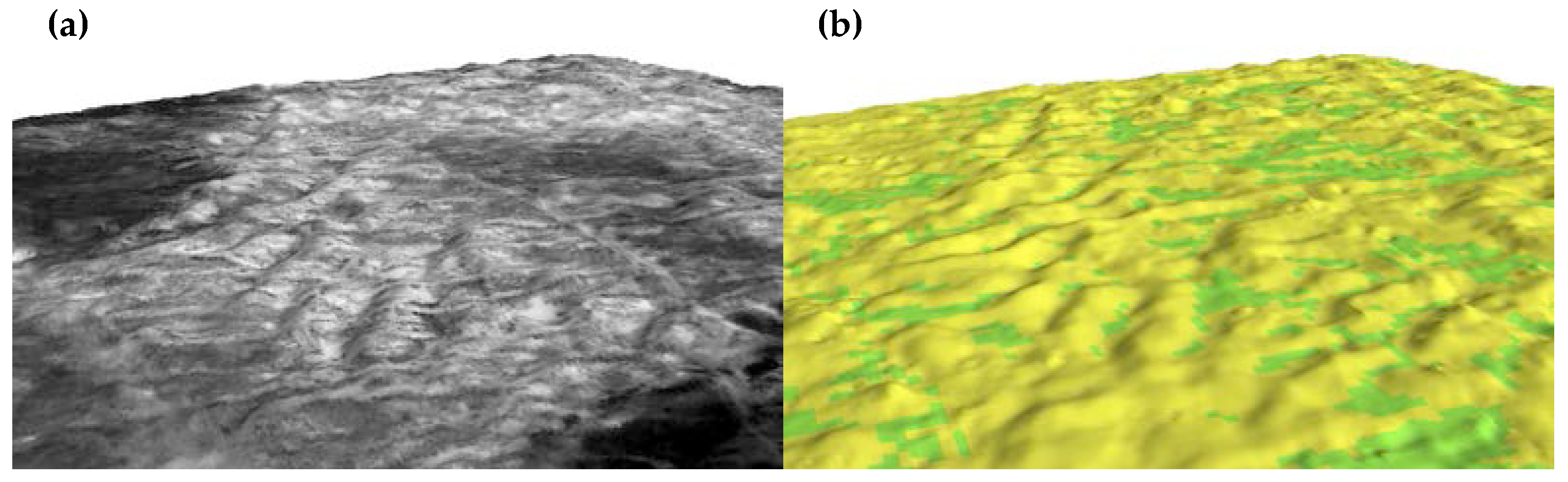
2.4. Generation of Digital Surface Model (DSM)
2.5. GIS-Based Classification of Sand-Dune Topography
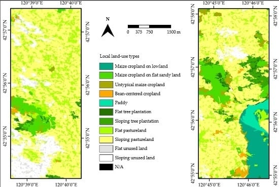
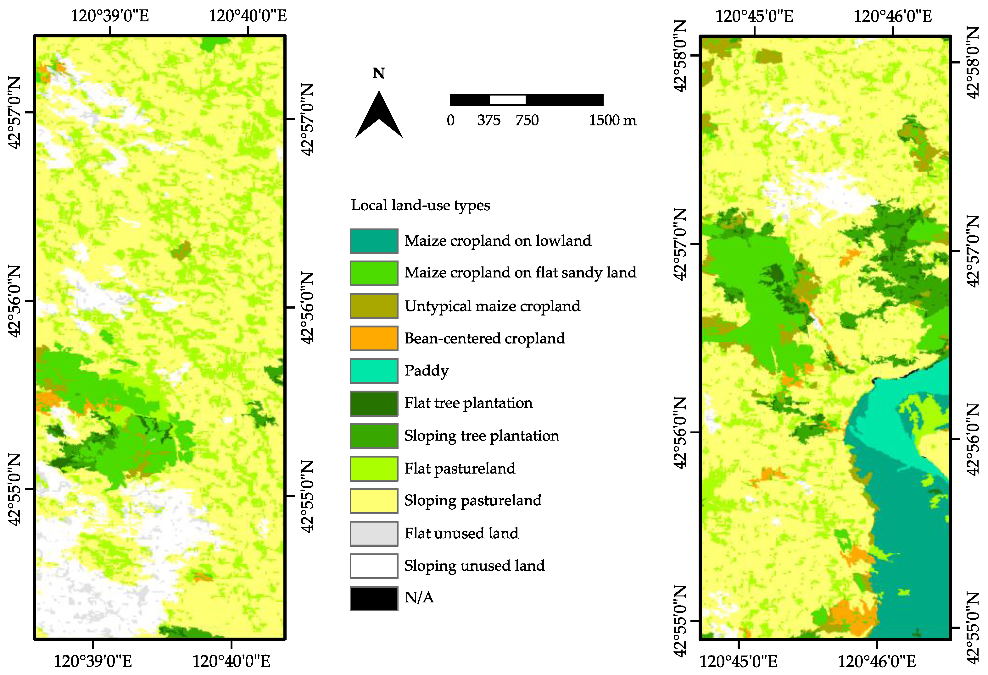
2.6. Depiction of Local Land-Use Types
3. Results and Discussion
3.1. Object-Based Classification of Preliminary Land-Use Types
3.2. Generation of DSM and GIS-Based Classification of Sand-Dune Topography
3.3. Depiction of Local Land-Use Types
4. Conclusions
Acknowledgments
Author Contributions
Conflicts of Interest
Abbreviations
| ALOS | Advanced Land Observing Satellite |
| ASTER GDEM | Advanced Spaceborne Thermal Emission and Reflection Radiometer Global Digital Elevation Model |
| AVNIR-2 | Advanced Visible and Near Infrared Radiometer type 2 |
| GIS | Geographic Information System |
| GPS | Global Positioning System |
| NDVI | Normalized Difference Vegetation Index |
| PRISM | Panchromatic Remote-sensing Instrument for Stereo Mapping |
| RMSE | Root Mean Square Error |
| RPC | Rational Polynomial Coefficients |
| TIN | Triangulated Irregular Network |
References
- Millennium Ecosystem Assessment. Ecosystems and Human Well-Being: Desertification Synthesis; World Resources Institute: Washington, DC, USA, 2005. [Google Scholar]
- McPeak, J.G. Analyzing and addressing localized degradation in the commons. Land Econ. 2003, 79, 515–536. [Google Scholar] [CrossRef]
- Lu, D.; Weng, Q. A survey of image classification methods and techniques for improving classification performance. Int. J. Remote Sens. 2007, 28, 823–870. [Google Scholar] [CrossRef]
- Lambin, E.F.; Geist, H.J.; Rindfuss, R.R. Introduction: Local processes with global impacts. In Land-Use and Land-Cover Change: Local Processes and Global Impacts; Lambin, E.F., Geist, H.J., Eds.; Springer: Berlin, Germany, 2006; pp. 1–8. [Google Scholar]
- Comber, A.J. The separation of land cover from land use using data primitives. J. Land Use Sci. 2008, 4, 215–229. [Google Scholar] [CrossRef]
- Beykaei, S.A.; Zhong, M.; Zhang, Y. Development of a land use extraction expert system through morphological and spatial arrangement analysis. Eng. Appl. Artif. Intel. 2015, 37, 221–235. [Google Scholar] [CrossRef]
- Kim, J.H. Crossing-over between land cover and land use: Exploring spatially varying relationships in two large US metropolitan areas. Appl. Geogr. 2015, 60, 37–45. [Google Scholar] [CrossRef]
- Li, F.R.; Zhang, H.; Zhao, L.Y.; Shirato, Y.; Wang, X.Z. Pedoecological effects of a sand-fixing poplar (Populus simonii Carr.) forest in a desertified sandy land of Inner Mongolia, China. Plant Soil 2003, 256, 431–442. [Google Scholar] [CrossRef]
- Okuro, T. Studies on the Influence of Grazing on the Land and Vegetation Degradation and Restoration Process in Grassland Regions in Northeast China. Ph.D. Thesis, The University of Tokyo, Tokyo, 1997. [Google Scholar]
- Miyasaka, T.; Okuro, T.; Miyamori, E.; Zhao, X.; Takeuchi, K. Effects of different restoration measures and sand dune topography on short- and long-term vegetation restoration in northeast China. J. Arid Environ. 2014, 111, 1–6. [Google Scholar] [CrossRef]
- Zuo, X.A.; Zhao, H.L.; Zhao, X.Y.; Guo, Y.R.; Li, Y.L; Luo, Y.Y. Plant distribution at the mobile dune scale and its relevance to soil properties and topographic features. Environ. Geol. 2008, 54, 1111–1120. [Google Scholar] [CrossRef]
- Zuo, X.A.; Zhao, H.L.; Zhao, X.Y.; Zhang, T.H.; Guo, Y.R.; Wang, S.K.; Drake, S. Spatial pattern and heterogeneity of soil properties in sand dunes under grazing and restoration in Horqin Sandy Land, Northern China. Soil Till. Res. 2008, 99, 202–212. [Google Scholar] [CrossRef]
- Zuo, X.A.; Zhao, X.Y.; Zhao, H.L.; Guo, Y.R.; Zhang, T.H.; Cui, J.Y. Spatial pattern and heterogeneity of soil organic carbon and nitrogen in sand dunes related to vegetation change and geomorphic position in Horqin Sandy Land, Northern China. Environ. Monit. Assess. 2010, 164, 29–42. [Google Scholar] [CrossRef] [PubMed]
- Zuo, X.A.; Zhao, X.Y.; Zhao, H.L.; Zhang, T.H.; Guo, Y.R.; Li, Y.Q.; Huang, Y.X. Spatial heterogeneity of soil properties and vegetation–soil relationships following vegetation restoration of mobile dunes in Horqin Sandy Land, Northern China. Plant Soil 2008, 318, 153–167. [Google Scholar] [CrossRef]
- Miyasaka, T.; Okuro, T.; Zhao, H.; Zhao, X.; Zuo, X.; Takeuchi, K. Impacts of the local land-use system in a semi-arid region of northeastern China on soil properties, crop growth, and weed communities. J. Arid Environ. 2011, 75, 1155–1163. [Google Scholar] [CrossRef]
- Duan, H.C.; Wang, T.; Xue, X.; Liu, S.L.; Guo, J. Dynamics of aeolian desertification and its driving forces in the Horqin Sandy Land, Northern China. Environ. Monit. Assess. 2014, 186, 6083–6096. [Google Scholar] [CrossRef] [PubMed]
- Han, Z.; Wang, T.; Yan, C.; Liu, Y.; Liu, L.; Li, A.; Du, H. Change trends for desertified lands in the Horqin Sandy Land at the beginning of the twenty-first century. Environ. Earth Sci. 2010, 59, 1749–1757. [Google Scholar] [CrossRef]
- Zhou, Y.; Chang, X.; Ye, S.; Zheng, Z.; Lv, S. Analysis on regional vegetation changes in dust and sandstorms source area: A case study of Naiman Banner in the Horqin sandy region of Northern China. Environ. Earth Sci. 2015, 73, 2013–2025. [Google Scholar] [CrossRef]
- Bagan, H.; Takeuchi, W.; Kinoshita, T.; Bao, Y.; Yamagata, Y. Land cover classification and change analysis in the Horqin Sandy Land from 1975 to 2007. IEEE J. Sel. Top. Appl. 2010, 3, 168–177. [Google Scholar] [CrossRef]
- Zheng, X.; Zhu, J.J.; Yan, Q.L.; Song, L.N. Effects of land use changes on the groundwater table and the decline of Pinus sylvestris var. mongolica plantations in southern Horqin Sandy Land, Northeast China. Agric. Water Manage. 2012, 109, 94–106. [Google Scholar] [CrossRef]
- Katoh, K.; Takeuchi, K.; Jiang, D.M.; Nan, Y.H.; Kou, Z.W. Vegetation restoration by seasonal exclosure in the Kerqin Sandy Land, Inner Mongolia. Plant Ecol. 1998, 139, 133–144. [Google Scholar] [CrossRef]
- Li, Y.L.; Cui, J.Y.; Zhang, T.H.; Okuro, T.; Drake, S. Effectiveness of sand-fixing measures on desert land restoration in Kerqin Sandy Land, northern China. Ecol. Eng. 2009, 35, 118–127. [Google Scholar] [CrossRef]
- Shirato, Y.; Taniyama, I.; Zhang, T.H. Changes in soil properties after afforestation in Horqin Sandy Land, North China. Soil Sci. Plant Nutr. 2004, 50, 537–543. [Google Scholar] [CrossRef]
- Su, Y.Z.; Li, Y.L.; Cui, J.Y.; Zhao, W.Z. Influences of continuous grazing and livestock exclusion on soil properties in a degraded sandy grassland, Inner Mongolia, northern China. Catena 2005, 59, 267–278. [Google Scholar]
- Zhang, J.; Zhao, H.; Zhang, T.; Zhao, X.; Drake, S. Community succession along a chronosequence of vegetation restoration on sand dunes in Horqin Sandy Land. J. Arid Environ. 2005, 62, 555–566. [Google Scholar] [CrossRef]
- Zhao, H.L.; Zhou, R.L.; Su, Y.Z.; Zhang, H.; Zhao, L.Y.; Drake, S. Shrub facilitation of desert land restoration in the Horqin Sand Land of Inner Mongolia. Ecol. Eng. 2007, 31, 1–8. [Google Scholar] [CrossRef]
- Tadono, T.; Shimada, M.; Murakami, H.; Takaku, J. Calibration of PRISM and AVNIR-2 onboard ALOS “Daichi”. IEEE Trans. Geosci. Remote 2009, 47, 4042–4050. [Google Scholar] [CrossRef]
- Benz, U.C.; Hofmann, P.; Willhauck, G.; Lingenfelder, I.; Heynen, M. Multi-resolution, object-oriented fuzzy analysis of remote sensing data for GIS-ready information. ISPRS J. Photogramm. 2004, 58, 239–258. [Google Scholar] [CrossRef]
- Müller, H.; Rufin, P.; Griffiths, P.; Barros Siqueira, A.J.; Hostert, P. Mining dense Landsat time series for separating cropland and pasture in a heterogeneous Brazilian savanna landscape. Remote Sens. Environ. 2015, 156, 490–499. [Google Scholar] [CrossRef]
- Baatz, M.; Benz, U.; Dehghani, S.; Heynen, M.; Höltje, A.; Hofmann, P.; Lingenfelder, I.; Mimler, M.; Sohlbach, M.; Weber, M.; et al. eCognition Version 4.0 User Guide; Definiens Imaging: Munich, Germany, 2004. [Google Scholar]
- Schiewe, J. Segmentation of high-resolution remotely sensed data-concepts, applications and problems. ISPRS Archives 2002, 34, 380–385. [Google Scholar]
- Platt, R.V.; Rapoza, L. An evaluation of an object-oriented paradigm for land use/land cover classification. Prof. Geogr. 2008, 60, 87–100. [Google Scholar] [CrossRef]
- Haralick, R.M.; Shanmuga, K.; Dinstein, I. Textural features for image classification. IEEE Trans. Syst. Man Cybern. 1973, 3, 610–621. [Google Scholar] [CrossRef]
- Leica Geosystems. Leica Photogrammetry Suite OrthoBASE and OrthoBASE pro User’s Guide; Leica Geosystems GIS and Mapping: Atlanta, GA, USA, 2003. [Google Scholar]
- Willhauck, G. Comparison of object oriented classification techniques and standard image analysis for the use of change detection between SPOT multispectral satellite images and aerial photos. ISPRS Archives 2000, 33, 214–222. [Google Scholar]
- Yu, Q.; Gong, P.; Clinton, N.; Biging, G.; Kelly, M.; Schirokauer, D. Object-based detailed vegetation classification with airborne high spatial resolution remote sensing imagery. Photogramm. Eng. Remote Sens. 2006, 72, 799–811. [Google Scholar] [CrossRef]
- Takaku, J.; Tadono, K.; Tsutsui, K. Generation of high resolution global DSM from ALOS PRISM. ISPRS Archives 2014, 40, 243–248. [Google Scholar] [CrossRef]
- Tachikawa, T.; Kaku, M.; Iwasaki, A.; Gesch, D.; Oimoen, M.; Zhang, Z.; Danielson, J.; Krieger, T.; Curtis, B.; Haase, J.; et al. ASTER Global Digital Elevation Model. Version 2–Summary of Validation Results; Meyer, D., Ed.; NASA Land Processes Distributed Active Archive Center: Washington, DC, USA, 2011. [Google Scholar]
- Telfer, M.W.; Fyfe, R.M.; Lewin, S. Automated mapping of linear dunefield morphometric parameters from remotely-sensed data. Aeolian Res. 2015, 19, 87–95. [Google Scholar] [CrossRef]
- White, K.; Bullard, J.; Livingstone, I.; Moran, L. A morphometric comparison of the Namib and southwest Kalahari dunefields using ASTER GDEM data. Aeolian Res. 2015, 19, 215–224. [Google Scholar] [CrossRef] [Green Version]
- ALOS Global Digital Surface Model "ALOS World 3D–30m" (AW3D30). Available on line: http://www.eorc.jaxa.jp/ALOS/en/aw3d30/ (accessed on 11 July 2016).
- Tadono, T.; Ishida, H.; Oda, F.; Naito, S.; Minakawa, K.; Iwamoto, H. Precise global DEM generation by ALOS PRISM. ISPRS Annals 2014, 2, 71–76. [Google Scholar] [CrossRef]
- Gibbes, C.; Adhikari, S.; Rostant, L.; Southworth, J.; Qiu, Y. Application of object based classification and high resolution satellite imagery for savanna ecosystem analysis. Remote Sens. 2010, 7, 2748–2772. [Google Scholar] [CrossRef]
- Castillejo-González, I.L.; López-Granados, F.; García-Ferrer, A.; Peña-Barragán, J.M.; Jurado-Expósito, M.; de la Orden, M.S.; González-Audicana, M. Object- and pixel-based analysis for mapping crops and their agro-environmental associated measures using QuickBird imagery. Comput. Electron. Agric. 2009, 68, 207–215. [Google Scholar] [CrossRef]
- Sweeney, S.; Ruseva, T.; Estes, L.; Evans, T. Mapping cropland in smallholder-dominated savannas: integrating remote sensing techniques and probabilistic modeling. Remote Sens. 2015, 7, 15295–15317. [Google Scholar] [CrossRef]
- Whiteside, T.G.; Boggs, G.S.; Maier, S.W. Comparing object-based and pixel-based classifications for mapping savannas. Int. J. Appl. Earth Obs. 2011, 13, 884–893. [Google Scholar] [CrossRef]
- Wu, J.G. Hierarchy and Scaling: Extrapolating information along a scaling ladder. Can. J. Remote Sens. 1999, 25, 367–380. [Google Scholar] [CrossRef]
- Wu, J.G.; Qi, Y. Dealing with scale in landscape analysis: an overview. Geogr. Inf. Sci. 2000, 6, 1–5. [Google Scholar] [CrossRef]
- Miyasaka, T.; Le, Q.B.; Okuro, T.; Zhao, X.; Scholz, R.W.; Takeuchi, K. An Agent-Based Model for Assessing Effects of a Chinese PES Program on Land-Use Change Along with Livelihood Dynamics, and Land Degradation and Restoration. In Managing Resources of a Limited Planet: Pathways and Visions under Uncertainty, Proceedings of the Sixth Biennial Meeting of the International Environmental Modelling and Software Society, Leipzig, Germany, 1–5 July 2012.


| Object-Based Classification | ||||||
|---|---|---|---|---|---|---|
| Accuracy measure | Maize cropland | Bean-centered cropland | Paddy | Pastureland | Unused land | Tree plantation |
| Producer’s accuracy | 91% | 63% | 100% | 96% | 94% | 65% |
| User’s accuracy | 91% | 71% | 100% | 96% | 80% | 73% |
| Overall accuracy | 93% | |||||
| Kappa statistic | 0.84 | |||||
| Pixel-Based Classification | ||||||
| Accuracy measure | Maize cropland | Bean-centered cropland | Paddy | Pastureland | Unused land | Tree plantation |
| Producer’s accuracy | 48% | 75% | 100% | 84% | 71% | 65% |
| User’s accuracy | 100% | 24% | 67% | 94% | 92% | 28% |
| Overall accuracy | 78% | |||||
| Kappa statistic | 0.57 | |||||
| Topographic Type | Maize Cropland | Bean-Centered Cropland | Paddy | Tree Plantation | Pastureland | Unused Land | Total |
|---|---|---|---|---|---|---|---|
| Lowland | 3.8% | 1.1% | 1.6% | 0.0% | 0.6% | 0.0% | 7.1% |
| Flat sandy land | 6.5% | 0.3% | 0.0% | 1.0% | 14.3% | 1.4% | 23.4% |
| Sand dune | 2.2% | 1.1% | 0.0% | 3.4% | 53.6% | 9.2% | 69.5% |
| Total | 12.5% | 2.5% | 1.6% | 4.4% | 68.4% | 10.6% | 100.0% |
© 2016 by the authors; licensee MDPI, Basel, Switzerland. This article is an open access article distributed under the terms and conditions of the Creative Commons Attribution (CC-BY) license (http://creativecommons.org/licenses/by/4.0/).
Share and Cite
Miyasaka, T.; Okuro, T.; Zhao, X.; Takeuchi, K. Classification of Land Use on Sand-Dune Topography by Object-Based Analysis, Digital Photogrammetry, and GIS Analysis in the Horqin Sandy Land, China. Environments 2016, 3, 17. https://doi.org/10.3390/environments3030017
Miyasaka T, Okuro T, Zhao X, Takeuchi K. Classification of Land Use on Sand-Dune Topography by Object-Based Analysis, Digital Photogrammetry, and GIS Analysis in the Horqin Sandy Land, China. Environments. 2016; 3(3):17. https://doi.org/10.3390/environments3030017
Chicago/Turabian StyleMiyasaka, Takafumi, Toshiya Okuro, Xueyong Zhao, and Kazuhiko Takeuchi. 2016. "Classification of Land Use on Sand-Dune Topography by Object-Based Analysis, Digital Photogrammetry, and GIS Analysis in the Horqin Sandy Land, China" Environments 3, no. 3: 17. https://doi.org/10.3390/environments3030017
APA StyleMiyasaka, T., Okuro, T., Zhao, X., & Takeuchi, K. (2016). Classification of Land Use on Sand-Dune Topography by Object-Based Analysis, Digital Photogrammetry, and GIS Analysis in the Horqin Sandy Land, China. Environments, 3(3), 17. https://doi.org/10.3390/environments3030017