
The Pine-Oak Forest of the Rio Conchos Basin, Mexico: Key to Rain Production and Soil Erosion Control

 ,
,  ,
,  and
and
Abstract
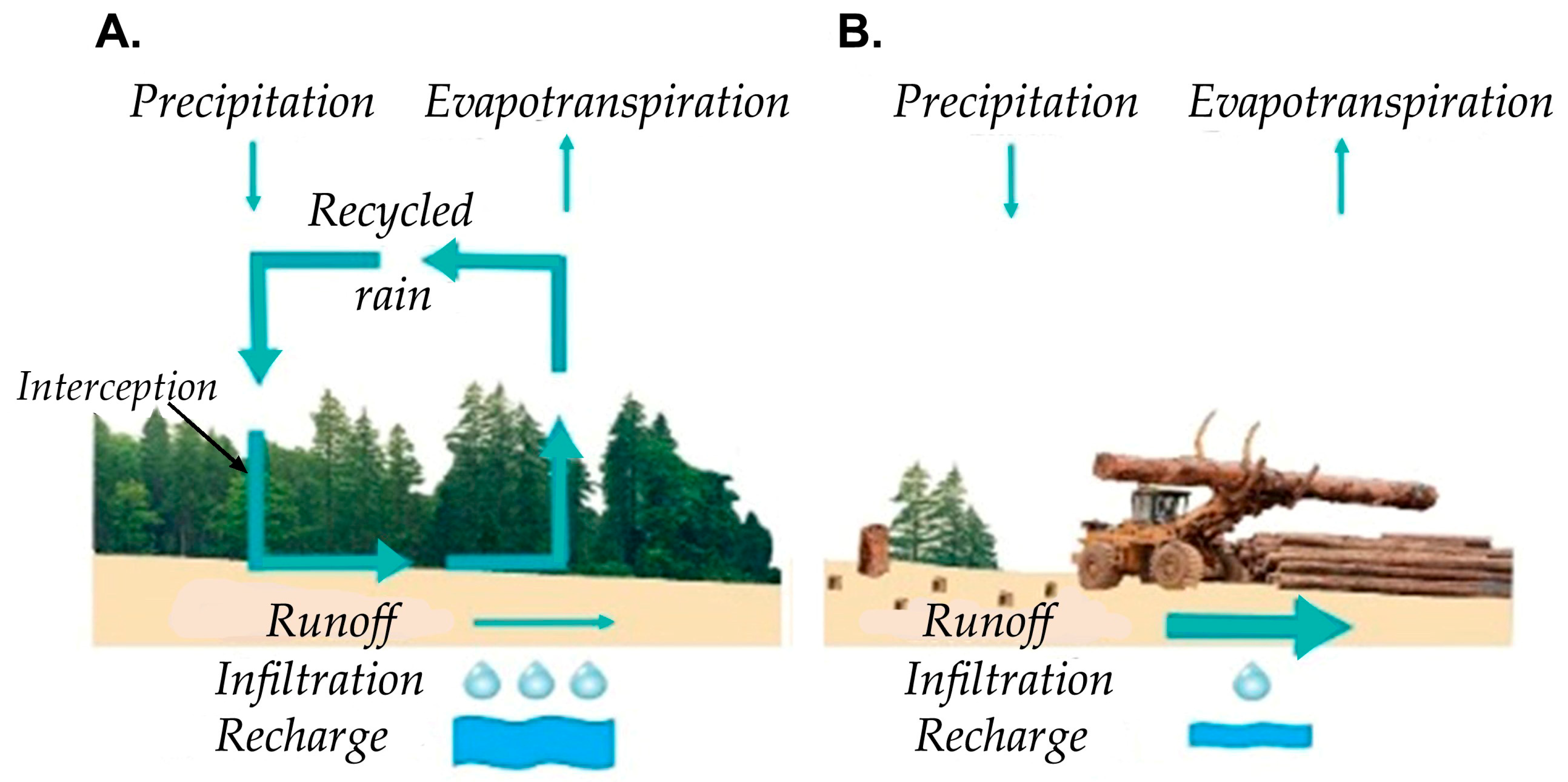
1. Introduction
2. Methods
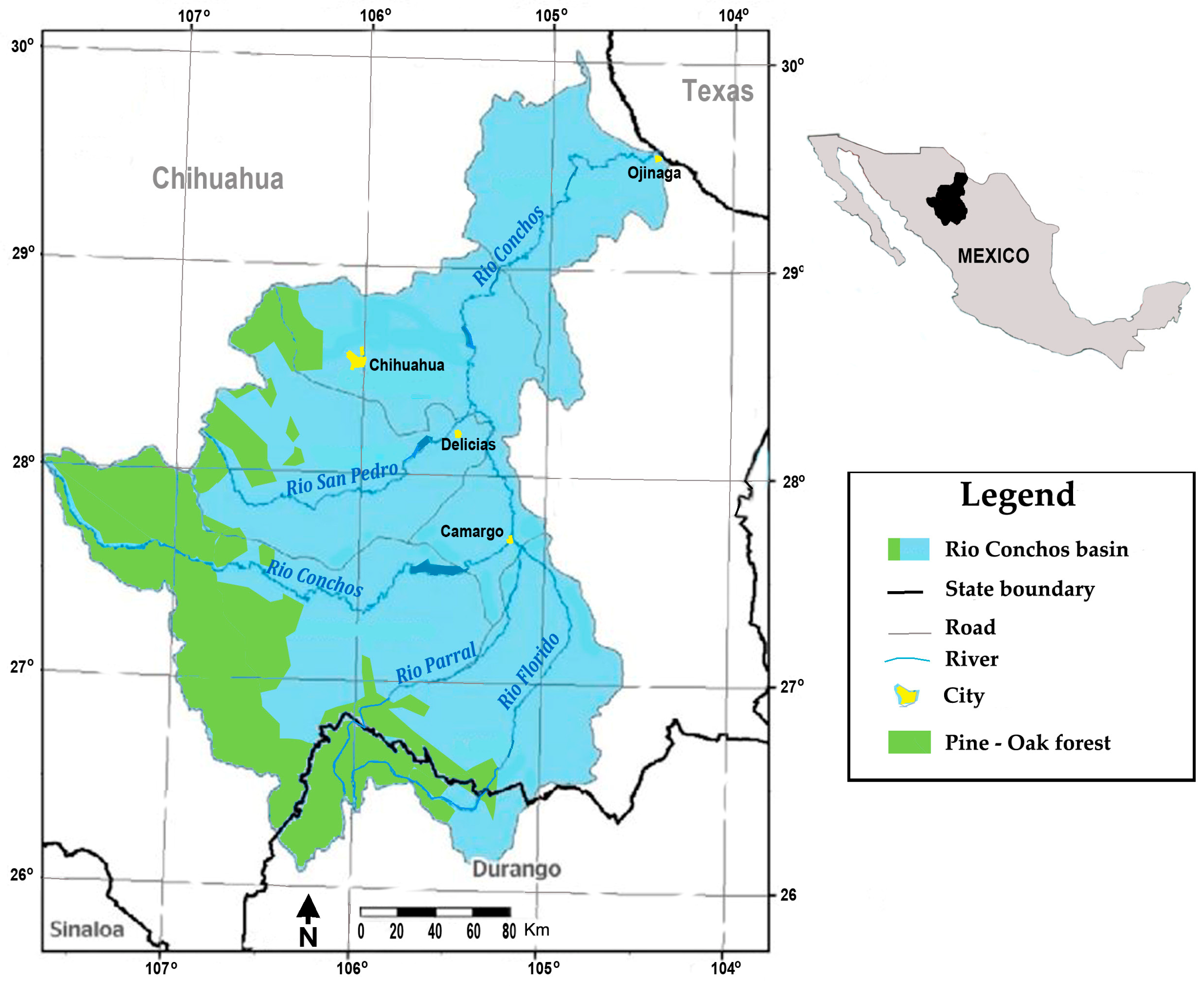
2.1. Study Area
2.2. Methodology
3. Results
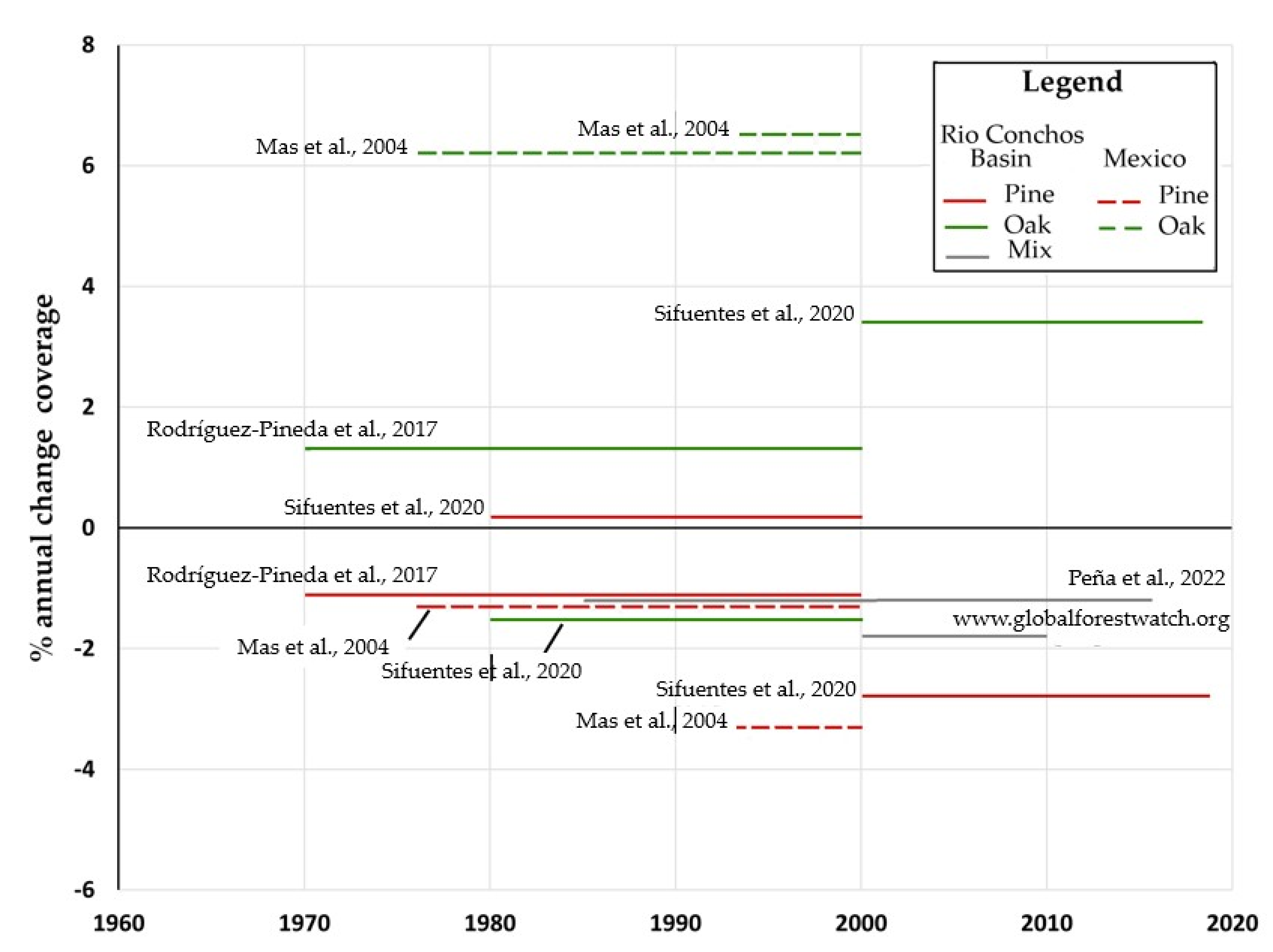
3.1. Reduction in Forest Coverage
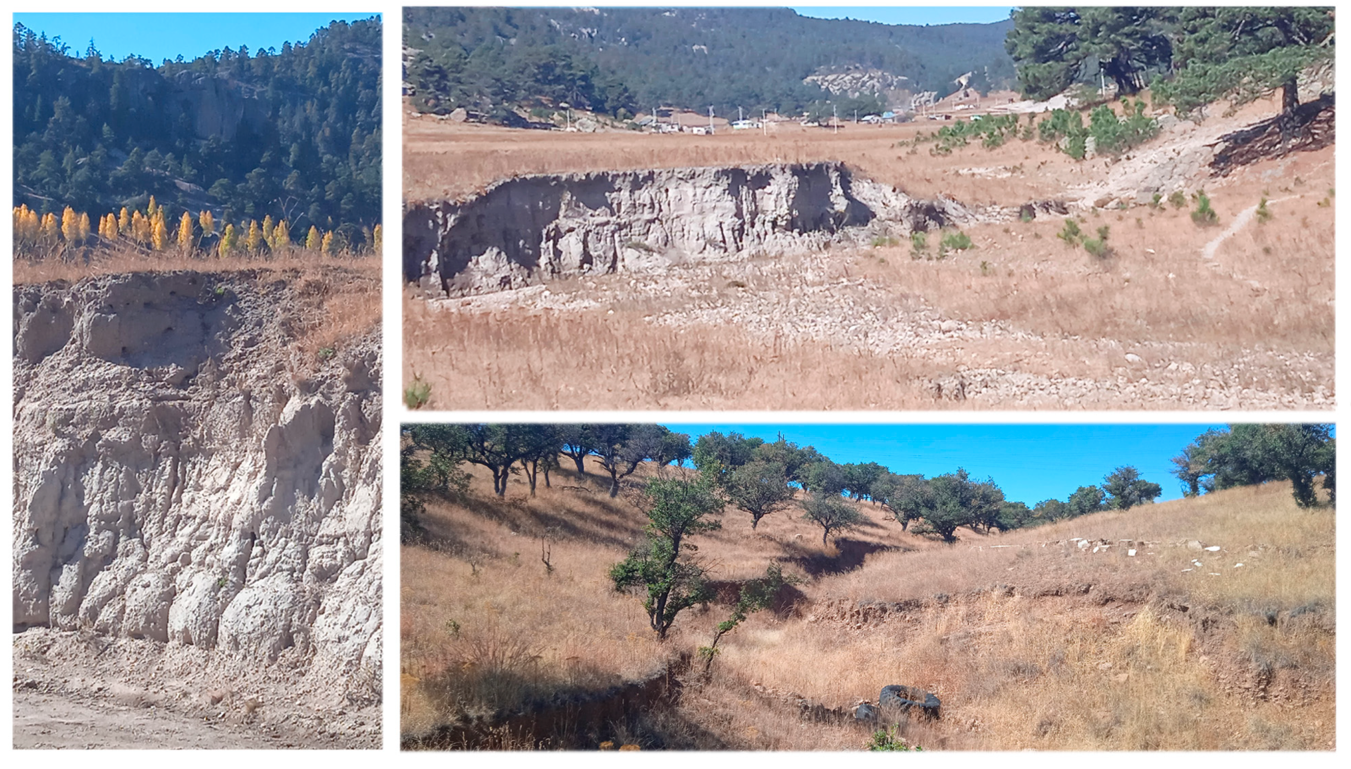
3.2. Hydric Soil Erosion
4. Recommended Actions towards Protecting the Forest Ecosystem
4.1. Potential for Reforestation in the Upper Rio Conchos Basin
4.2. Computer Modeling
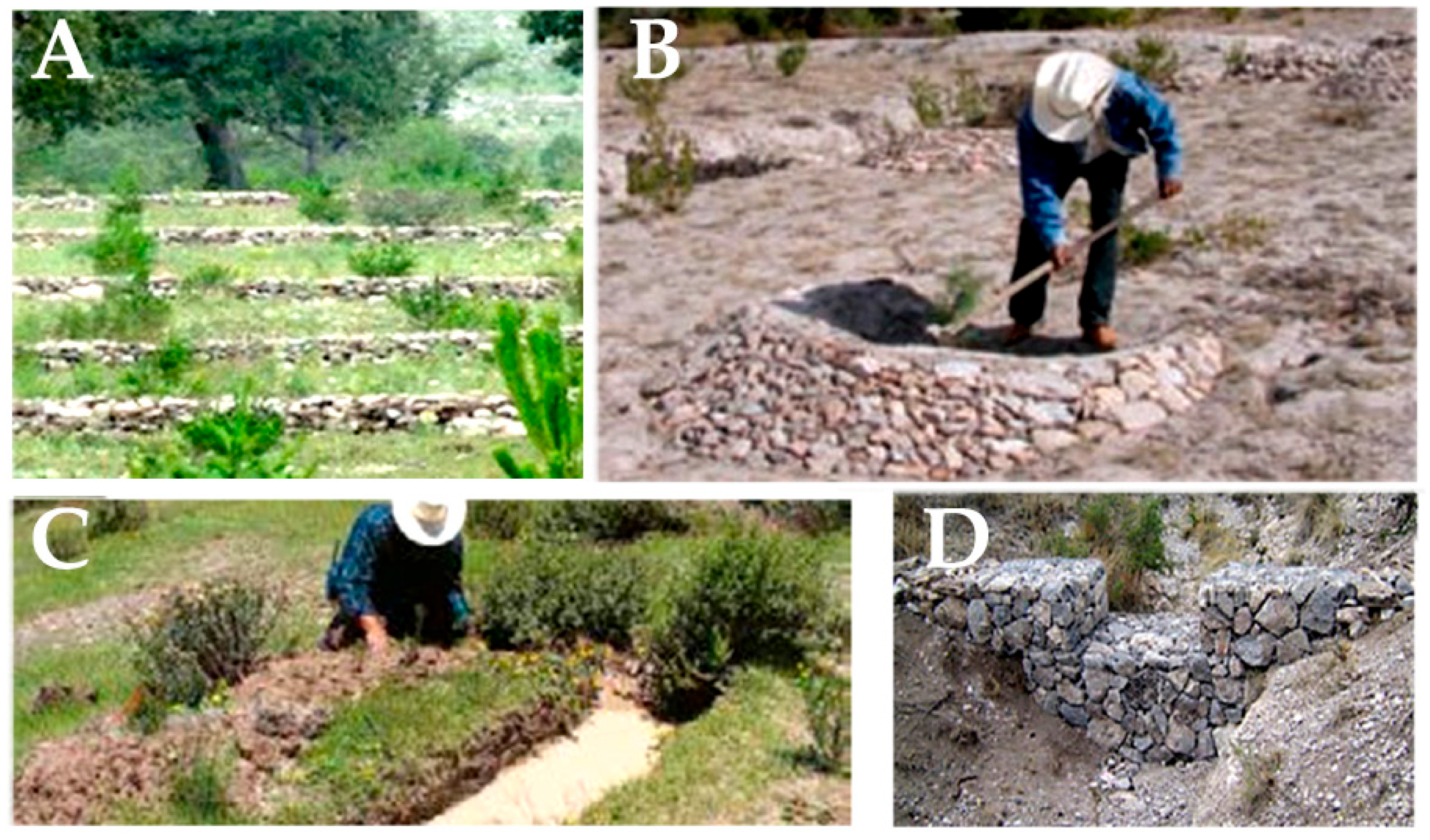
4.3. Non-Traditional Methods
5. Conclusions
Author Contributions
Funding
Informed Consent Statement
Data Availability Statement
Acknowledgments
Conflicts of Interest
References
- Bates, B.C.; Kundzewicz, Z.W.; Wu, S.; Palutikof, J.P. (Eds.) Climate Change and Water. In Technical Paper of the Intergovern-Mental Panel on Climate Change; Technical Paper VI; IPCC Secretariat: Geneva, Switzerland, 2008; 210p. [Google Scholar]
- Ellison, D.; Morris, C.E.; Locatelli, B.; Sheil, D.; Cohen, J.; Murdiyarso, D.; Gutierrez, V.; van Noordwijk, M.; Creed, I.F.; Pokorny, J.; et al. Trees, forests and water: Cool insights for a hot world. Glob. Environ. Chang. 2017, 43, 51–61. [Google Scholar] [CrossRef]
- Aragão, L.E.O.C. The rainforest’s water pump. Nature 2012, 489, 217–218. [Google Scholar] [CrossRef] [PubMed]
- Mendoza-Ponce, A.; Corona-Núñez, R.; Kraxner, F.; Leduc, S.; Patrizio, P. Identifying effects of land use cover changes and climate change on terrestrial ecosystems and carbon stocks in Mexico. Glob. Environ. Chang. 2018, 53, 12–23. [Google Scholar] [CrossRef]
- Pörtner, H.O.; Scholes, R.J.; Agard, J.; Archer, E.; Arneth, A.; Bai, X.; Barnes, D.; Burrows, M.; Chan, L.; Cheung, W.L.; et al. Scientific Outcome of the IPBES-IPCC Co-Sponsored Workshop on Biodiversity and Climate Change; IPBES Secretariat: Bonn, Germany, 2021; 256p. [Google Scholar]
- Pennisi, E. How to regrow a forest? Scientists aren’t sure. Science 2022, 378, 816–817. [Google Scholar] [CrossRef]
- Herring, S.C.; Hoerling, M.P.; Kossin, J.P.; Peterson, T.C.; Stott, P.A. Explaining extreme events of 2014 from a climate perspective. Bull. Am. Meteorol. Soc. 2015, 96, S1–S172. [Google Scholar] [CrossRef]
- FAO. Global Forest Resources Assessment 2020; Main Report; U.N. Food and Agricultural Organization: Rome, Italy, 2020; 16p. [Google Scholar] [CrossRef]
- Fischer, E.M.; Knutti, R. Anthropogenic contribution to global occurrence of heavy-precipitation and high-temperature extremes. Nat. Clim. Chang. 2015, 5, 560–564. [Google Scholar] [CrossRef]
- Hu, X.; Næss, J.S.; Iordan, C.M.; Huang, B.; Zhao, W.; Cherubini, F. Recent global land cover dynamics and implications for soil erosion and carbon losses from deforestation. Anthropocene 2021, 34, 100291. [Google Scholar] [CrossRef]
- Schwartz, J.D. Clearing Forests May Transform Local—And Global—Climate. Scientific American. 2013. Available online: https://www.scientificamerican.com/article/clearing-forests-may-transform-local-and-global-climate/ (accessed on 1 January 2020).
- Correa-Díaz, A.; Silva, L.C.R.; Horwath, W.R.; Gómez-Guerrero, A.; Vargas-Hernández, J.; Villanueva-Díaz, J.; Velázquez-Martínez, A.; Suárez-Espinoza, J. Linking Remote Sensing and Dendrochronology to Quantify Climate-Induced Shifts in High-Elevation Forests Over Space and Time. J. Geophys. Res. Biogeosciences 2019, 124, 166–183. [Google Scholar] [CrossRef]
- Ibarra-Bonilla, J.S.; Villarreal-Guerrero, F.; Prieto-Amparán, J.A.; Santellano-Estrada, E.; Pinedo-Alvarez, A. Characterizing the impact of Land-Use/Land-Cover changes on a Temperate Forest using the Markov model. Egypt. J. Remote Sens. Space Sci. 2021, 24, 1013–1022. [Google Scholar] [CrossRef]
- Falk, D.A.; van Mantgem, P.J.; Keeley, J.E.; Gregg, R.M.; Guiterman, C.H.; Tepley, A.J.; Young, D.J.; Marshall, L.A. Mechanisms of forest resilience. For. Ecol. Manag. 2022, 512, 120129. [Google Scholar] [CrossRef]
- Armenteras, D.; Espelta, J.M.; Rodríguez, N.; Retana, J. Deforestation dynamics and drivers in different forest types in Latin America: Three decades of studies (1980–2010). Glob. Environ. Chang. 2017, 46, 139–147. [Google Scholar] [CrossRef]
- Maciel-Nájera, J.F.; Hernández-Velasco, J.; González-Elizondo, M.S.; Hernández-Díaz, J.C.; López-Sánchez, C.A.; Antúnez, P.; Bailón-Soto, C.E.; Wehenkel, C. Unexpected spatial patterns of natural regeneration in typical uneven-aged mixed pine-oak forests in the Sierra Madre Occidental, Mexico. Glob. Ecol. Conserv. 2020, 23, e01074. [Google Scholar] [CrossRef]
- Martínez-Sifuentes, A.R.; Villanueva-Díaz, J.; Estrada-Ávalos, J.; Trucíos-Caciano, R.; Carlón-Allende, T.; Castruita-Esparza, L.U. Two Centuries of Drought History in the Center of Chihuahua, Mexico. Forests 2022, 13, 921. [Google Scholar] [CrossRef]
- Shukla, J.; Mintz, Y. Influence of land-surface evapotranspiration on the Earth’s climate. Science 1982, 215, 1498–1501. [Google Scholar] [CrossRef] [PubMed]
- Spracklen, D.V.; Arnold, S.R.; Taylor, C.M. Observations of increased tropical rainfall preceded by air passage over forests. Nature 2012, 489, 282–285. [Google Scholar] [CrossRef] [PubMed]
- Wright, J.S.; Fu, R.; Worden, J.R.; Chakraborty, S.; Clinton, N.E.; Risi, C.; Sun, Y.; Yin, L. Rainforest-initiated wet season onset over the southern Amazon. Proc. Natl. Acad. Sci. USA 2017, 114, 8481–8486. [Google Scholar] [CrossRef] [PubMed]
- Nair, U.S.; Wu, Y.; Kala, J.; Lyons, T.J.; Pielke, R.A.; Hacker, J.M. The role of land use change on the development and evolution of the west coast trough, convective clouds, and precipitation in southwest Australia. J. Geophys. Res. Atmos. 2011, 116, D07103. [Google Scholar] [CrossRef]
- Borrelli, P.; Robinson, D.A.; Panagos, P.; Lugato, E.; Yang, J.E.; Alewell, C.; Wuepper, D.; Montanarella, L.; Ballabio, C. Land use and climate change impacts on global soil erosion by water (2015-2070). Proc. Natl. Acad. Sci. USA 2020, 117, 21994–22001. [Google Scholar] [CrossRef]
- del Campo, A.D.; Otsuki, K.; Serengil, Y.; Blanco, J.A.; Yousefpour, R.; Wei, X. A global synthesis on the effects of thinning on hydrological processes: Implications for forest management. For. Ecol. Manag. 2022, 519, 120324. [Google Scholar] [CrossRef]
- Hao, L.; Pan, C.; Fang, D.; Zhang, X.; Zhou, D.; Liu, P.; Liu, Y.; Sun, G. Quantifying the effects of overgrazing on mountainous watershed vegetation dynamics under a changing climate. Sci. Total. Environ. 2018, 639, 1408–1420. [Google Scholar] [CrossRef]
- González-Abraham, C.; Flores-Santana, C.; Rodríguez-Ramírez, S.; Olguín-Álvarez, M.; Flores-Martínez, A.; Rojo, J.M.T.; Verdinelli, G.B.; Calleros, C.A.F.; McCord, G.C. Long-term pathways analysis to assess the feasibility of sustainable land-use and food systems in Mexico. Sustain. Sci. 2022, 18, 469–484. [Google Scholar] [CrossRef]
- Rodríguez-Pineda, J.A.; Carreón, E.; Lafón, A.; Santos, J.; Rios, R. Cambio de uso de suelo en la cuenca del rio Conchos, Chihuahua, México. In Cuenca del Rio Conchos: Una mirada Desde las Ciencias ante el Cambio Climático; Instituto Mexicano de Tecnología del Agua: Jiutepec, México, 2017; pp. 157–204. ISBN 978-607-9368-90-0. [Google Scholar]
- Monarrez-Gonzalez, J.C.; Gonzalez-Elizondo, M.S.; Marquez-Linares, M.A.; Gutierrez-Yurrita, P.J.; Perez-Verdin, G. Effect of forest management on tree diversity in temperate ecosystem forests in northern Mexico. PLoS ONE 2020, 15, e0233292. [Google Scholar] [CrossRef] [PubMed]
- Salvador, M.M.; Pérez, G.S.; Sotelo, J.M.C.; Álvarez, A.P.; Guerrero, F.V.; Amparan, J.A.P. El monitoreo forestal por medio de sitios permanentes de investigación silvícola en Chihuahua, México. Rev. Mex. Cienc. For. 2019, 10, 56–78. [Google Scholar] [CrossRef]
- Castruita-Esparza, L.U.; Silva, L.C.; Gómez-Guerrero, A.; Villanueva-Díaz, J.; Correa-Díaz, A.; Horwath, W.R. Coping with Extreme Events: Growth and Water-Use Efficiency of Trees in Western Mexico During the Driest and Wettest Periods of the Past One Hundred Sixty Years. J. Geophys. Res. Biogeosciences 2019, 124, 3419–3431. [Google Scholar] [CrossRef]
- Mas, J.-F.; Velázquez, A.; Díaz-Gallegos, J.R.; Mayorga-Saucedo, R.; Alcántara, C.; Bocco, G.; Castro, R.; Fernández, T.; Pérez-Vega, A. Assessing land use/cover changes: A nationwide multidate spatial database for Mexico. Int. J. Appl. Earth Obs. Geoinformation 2004, 5, 249–261. [Google Scholar] [CrossRef]
- Gómez-Guerrero, A.; Correa-Díaz, A.; Castruita-Esparza, L.U. Cambio climático y dinámica de los ecosistemas forestales. Rev. Fitotec. Mex. 2021, 44, 673. [Google Scholar] [CrossRef]
- Peña, L.C.B.; Córdova, M.O.G.; Cejudo, L.C.A.; Olave, M.E.T.; Murrieta, R.L.M.; Aguilar, V.M.S.; Villalobos, H.L.R.; Gómez, V.M.R.; Campos, M.I.U.; León, M.O.G. Degradación y deforestación en la cuenca del río Conchos (México): Modelado predictivo mediante regresión logística (1985–2016). Cuadernos Geográficos 2022, 61, 129–149. [Google Scholar] [CrossRef]
- Peña, L.C.B.; Olave, M.E.T.; Cejudo, L.C.A.; Villegas, A.E.C.; Murrieta, R.L.M.; Olivas, A.G.; Campos, M.U. Áreas probables de degradación-deforestación de la cubierta vegetal en chihuahua, méxico. una exploración mediante regresión logística para el período 1985-2013. GeoFocus. Rev. Int. Ciencia Tecnol. Inform. Geogr. 2017, 20, 109–137. [Google Scholar] [CrossRef]
- Moreno-González, I.; Pineda-Jaimes, N.B.; Manzano-Solís, L.R.; Némiga, X.A. Análisis espacial de los cambios de uso de suelo, vegetación y cuerpos de agua en el estado de Nayarit, México, 1993-2014. Cuad. Geográficos Am. Cent. 2022, 2, 199–223. [Google Scholar] [CrossRef]
- Peña, L.C.B.; Gómez, V.M.R.; Murrieta, R.L.M.; Cejudo, L.C.A.; Olave, M.E.T.; Olivas, A.G.; Hernández, H.A.F. Cambios del uso del suelo e impactos en la escorrentía potencial de la cuenca Chuviscar-Sacramento (Chihuahua, México). GeoFocus. Rev. Int. Ciencia Tecnol. Inform. Geog. 2020, 26, 69–91. [Google Scholar] [CrossRef]
- Horton, A.J.; Nygren, A.; A Diaz-Perera, M.; Kummu, M. Flood severity along the Usumacinta River, Mexico: Identifying the anthropogenic signature of tropical forest conversion. J. Hydrol. X 2020, 10, 100072. [Google Scholar] [CrossRef]
- Trucíos, R.; Rivera, M.; Delgado, G.; Estrada, J.; Cerano, J. Análisis sobre cambio de uso de suelo en dos escalas de trabajo. Terra Latinoam. 2013, 31, 339–346. [Google Scholar]
- Sifuentes, A.R.M.; Díaz, J.V.; Ávalos, J.E.; Vázquez, C.V.; Castillo, I.O. Pérdida de suelo y modificación de escurrimientos causados por el cambio de uso de la tierra en la cuenca del río Conchos, Chihuahua. Nova Sci. 2020, 12, 1–26. [Google Scholar] [CrossRef]
- Silva-Rodríguez, S. Estudio Regional Forestal de la UMAFOR San Juanito, Clave 08-05; Unidad de Mane-jo Forestal San Juanito A. C. y Consultoría Ecosistemas y Medio Ambiente Sierra Madre, S.C. Mexico: Estado de Chihuahua, Mexico, 2009; 266p. [Google Scholar]
- Global Forest Watch: Forest Monitoring Designed for Action. Available online: https://www.globalforestwatch.org (accessed on 28 February 2020).
- García, S.A.G.; Flores, R.N.; García, J.M.O.; Salas, J.H. Diversidad y estructura vertical del bosque de pino–encino en Guadalupe y Calvo, Chihuahua. Rev. Mex. Cienc. For. 2019, 10, 41–63. [Google Scholar] [CrossRef]
- Secretaria del Medio Ambiente y Recursos Naturales-Colegio de Postgraduados. Evaluación de la degradación del suelo causada por el hombre en la República Mexicana Escala 1: 250.000; Memoria Nacional 2001–2002; Publicaciones Diamante: San Vicente Chicoloapan, Mexico, 2003. [Google Scholar]
- González-Villela, R.; Montero-Martínez, M.J.; Santana-Sepúlveda, J.S. Repercusiones del Cambio Climático en el Caudal Ecológico en el río Conchos. In Cuenca del Rio Conchos: Una Mirada Desde las Ciencias Ante el Cambio Climático; Instituto Mexicano de Tecnología del Agua: Jiutepec, México, 2017; pp. 109–156. ISBN 978-607-9368-90-0. [Google Scholar]
- Montero-Martínez, M.J.; Santana-Sepúlveda, J.S.; Mateos-Farfán, E.; Ibáñez-Hernández, O.F. Análisis de precipitación ex-trema para la cuenca del río Conchos usando el Índice Normalizado de Precipitación. In Cuenca del Rio Conchos: Una mirada Desde las Ciencias Ante el Cambio Climático; Instituto Mexicano de Tecnología del Agua: Jiutepec, México, 2017; pp. 85–108. ISBN 978-607-9368-90-0. [Google Scholar]
- Correa-Díaz, A.; Silva, L.C.R.; Horwath, W.R.; Gómez-Guerrero, A.; Vargas-Hernández, J.; Villanueva-Díaz, J.; Suárez-Espinoza, J.; Velázquez-Martínez, A. From Trees to Ecosystems: Spatiotemporal Scaling of Climatic Impacts on Montane Landscapes Using Dendrochronological, Isotopic, and Remotely Sensed Data. Glob. Biogeochem. Cycles 2020, 34, e2019GB006325. [Google Scholar] [CrossRef]
- Cabral-Alemán, C.; Villanueva-Díaz, J.; Quiñonez-Barraza, G.; Gómez-Guerrero, A. Resilience of Pinus durangensis Martínez in Extreme Drought Periods: Vertical and Horizontal Response of Tree Rings. Atmosphere 2022, 14, 43. [Google Scholar] [CrossRef]
- Cardoza-Vázquez, R.; Cuevas-Flores, L.; García-Carreón, J.S.; Guerrero-Herrera, J.A.; González-Olarte, J.C.; Mendez, H.H.; Quintero, M.d.L.L.; Frausto, J.L.N.; Sartorius, D.T.; Vazquez, C.M.V.M.R.C. Protección, Restauración y Conservación de Suelos Forestales: Manual de Obras y Prácticas, 5th ed.; Comisión Nacional Forestal (CONAFOR): Zapopan, Mexico, 2018; 298p. [Google Scholar]
- Gómez-Ruiz, P.A.; Sáenz-Romero, C.; Lindig-Cisneros, R. Early performance of two tropical dry forest species after assisted migration to pine–oak forests at different altitudes: Strategic response to climate change. J. For. Res. 2019, 31, 1215–1223. [Google Scholar] [CrossRef]
- Cruz-Garcia, F.; González, J.C.M.; Tecle, A.; Wehenkel, C.; Perez-Verdin, G. Effects of stand variables on stemflow and surface runoff in pine-oak forests in northern Mexico. PLoS ONE 2020, 15, e0235320. [Google Scholar] [CrossRef]


| Zone Period of Study | Forest Cover, in Hectares (ha) (S. = Surface Area, Ch = Change), | Annual % Change | Land Use Change | Reference |
|---|---|---|---|---|
| Mexico 1976–2000 | S. Primary temperate forests 1976: 303,087 Ch: −93,870 S. Secondary temperate forest 1976: 48,954 Ch: +73,058 | −1.3% +6.2% | The study includes different types of vegetation cover and compares two periods, 1976–2000 and 1993–2000. | [30] |
| Mexico 1993–2000 | S. Primary temperate forest 1993: 268,499 Ch: −63,074 = −0.23% S. Secondary temperate forest 1993: 84,470 Ch. +38,576 | −3.3% +6.5% | [30] | |
| Rio Conchos basin 1970–2000 | S. pine 1970: 14,978 Ch: −5162 S. oak 1970: 4109 Ch: +1634 | −1.1% +1.3% | Deforestation; forest replaced by desert shrub and agriculture | [26] |
| Rio Conchos basin 1980–2000 | S. pine 1980: 10,327 Ch: +443 S. oak 1980:1515 Ch: −467 | +0.2% −1.5% | Increase in pine and agri-culture covers, reduction in grass and oak covers | [38] |
| Rio Conchos basin 2000–2018 | S. pine 2000: 10,770 Ch: −5566 S. oak 2000: 1048 Ch: +6.32 | −2.8% +3.4% | Deforestation of pine cover, increase in oak cover | [38] |
| Rio Conchos basin 1985–2016 | Pine, oak and mix S. 2016: 10,970 Ch: −4201 | −1.2% | Secondary vegetation S. 2016: 475,760 ha, Change: +250,350 ha | [32] |
| Five counties in the upper Rio Conchos basin: Balleza, Bocoyna, Carichi, Nonoava, San Fco. Borja, 2000–2010 | Change in forest cover −2542 | −1.8% | Deforestation and degradation, no distinction made between pine and oak | [40] |
| Study Area | Soil Erosion, in Metric Tonnes ha−1 year−1, or % Surface Area | Change in Land Use | Ref. |
|---|---|---|---|
| Rio Conchos basin 1980–2018 | 1980: 1.45 2018: 2.47 | increase in pine forests, reduction in oak forest in 1980–2000; opposite results in the 2000–2018 period | [38] |
| Rio Conchos basin 1960–1983 vs. 1894–2008 | Increment of minimal flows in dry season and increase in the duration of high flow pulses | Variation of precipitation pattern both in high flow pulses and low flow pulses, conducive to an increase in soil erosion rate | [43] |
| Rio Conchos basin 1960–1983 vs. 1894–2008 | Increase in extreme values of drought and precipitation in the past few decades, |SPI| > 1.5, | Analysis based on the normalized precipitation index SPI | [44] |
| Chuvíscar-Sacramento basin 2000–2017 | Increase in runoff depth, higher in zones with a decrease in forest cover | Decrease in forest cover from 614 km2 in 2000, to 540 km2 in 2017 | [35] |
| Estado de Chihuahua 2001–2002 | % surface area affected by hydric erosion: Severely affected: 0.10% Degraded: 12.0% | % surface area affected by physical erosion: Severely affected: 0.18% Degraded: 4.0% | [42] |
Disclaimer/Publisher’s Note: The statements, opinions and data contained in all publications are solely those of the individual author(s) and contributor(s) and not of MDPI and/or the editor(s). MDPI and/or the editor(s) disclaim responsibility for any injury to people or property resulting from any ideas, methods, instructions or products referred to in the content. |
© 2023 by the authors. Licensee MDPI, Basel, Switzerland. This article is an open access article distributed under the terms and conditions of the Creative Commons Attribution (CC BY) license (https://creativecommons.org/licenses/by/4.0/).
Share and Cite
Castruita-Esparza, L.U.; Gutiérrez, M.; Olivas-García, J.M.; Rubio-Arias, H.O. The Pine-Oak Forest of the Rio Conchos Basin, Mexico: Key to Rain Production and Soil Erosion Control. Environments 2023, 10, 37. https://doi.org/10.3390/environments10030037
Castruita-Esparza LU, Gutiérrez M, Olivas-García JM, Rubio-Arias HO. The Pine-Oak Forest of the Rio Conchos Basin, Mexico: Key to Rain Production and Soil Erosion Control. Environments. 2023; 10(3):37. https://doi.org/10.3390/environments10030037
Chicago/Turabian StyleCastruita-Esparza, Luis U., Mélida Gutiérrez, Jesús M. Olivas-García, and Hector O. Rubio-Arias. 2023. "The Pine-Oak Forest of the Rio Conchos Basin, Mexico: Key to Rain Production and Soil Erosion Control" Environments 10, no. 3: 37. https://doi.org/10.3390/environments10030037
APA StyleCastruita-Esparza, L. U., Gutiérrez, M., Olivas-García, J. M., & Rubio-Arias, H. O. (2023). The Pine-Oak Forest of the Rio Conchos Basin, Mexico: Key to Rain Production and Soil Erosion Control. Environments, 10(3), 37. https://doi.org/10.3390/environments10030037