Monitoring Coastline Dynamics of Alakol Lake in Kazakhstan Using Remote Sensing Data

Abstract
:1. Introduction
2. Materials and Methods
2.1. Satellite Images
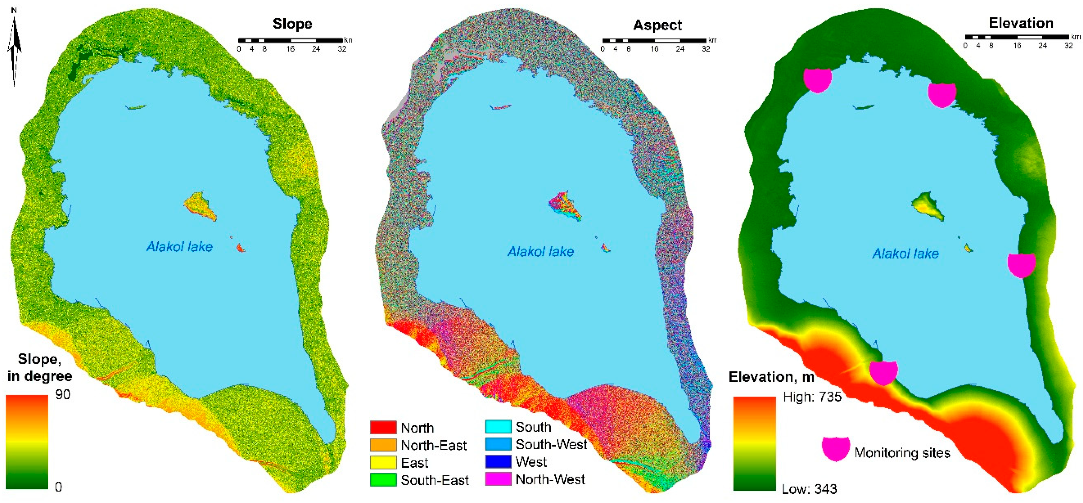
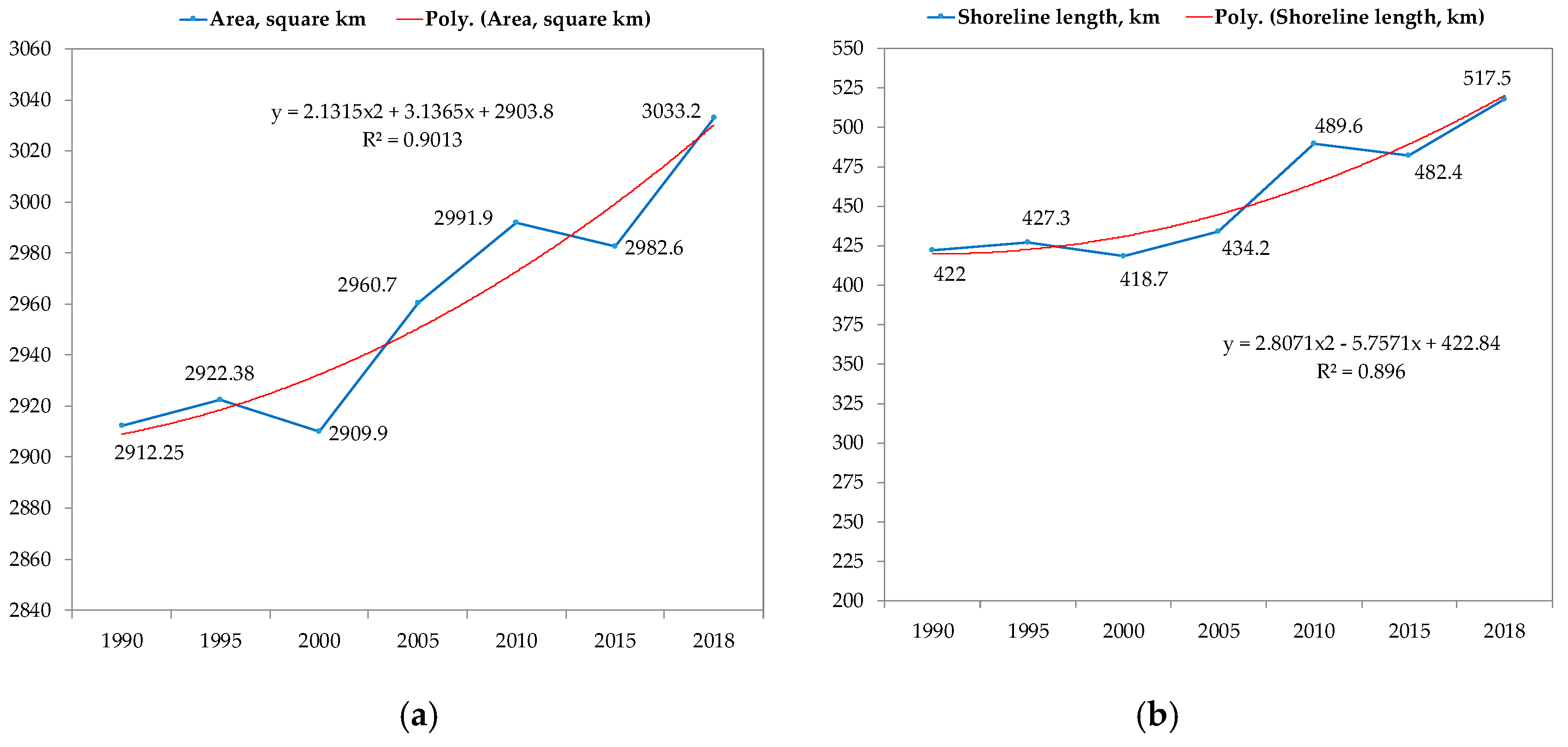
2.2. Morphometric Conditions
2.3. Water Index
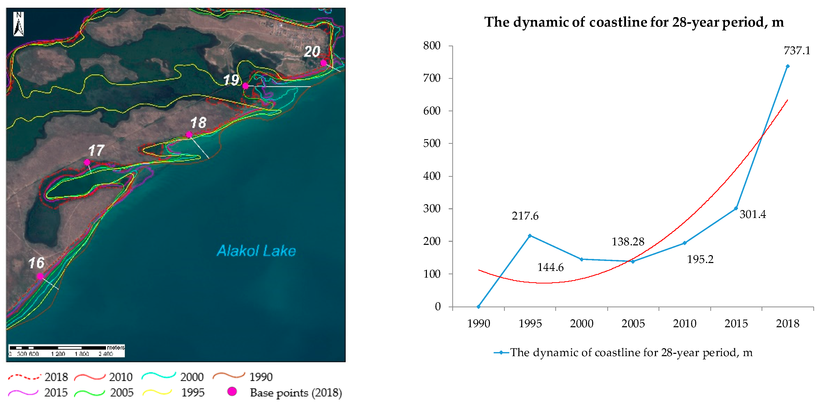
3. Results
- ▪
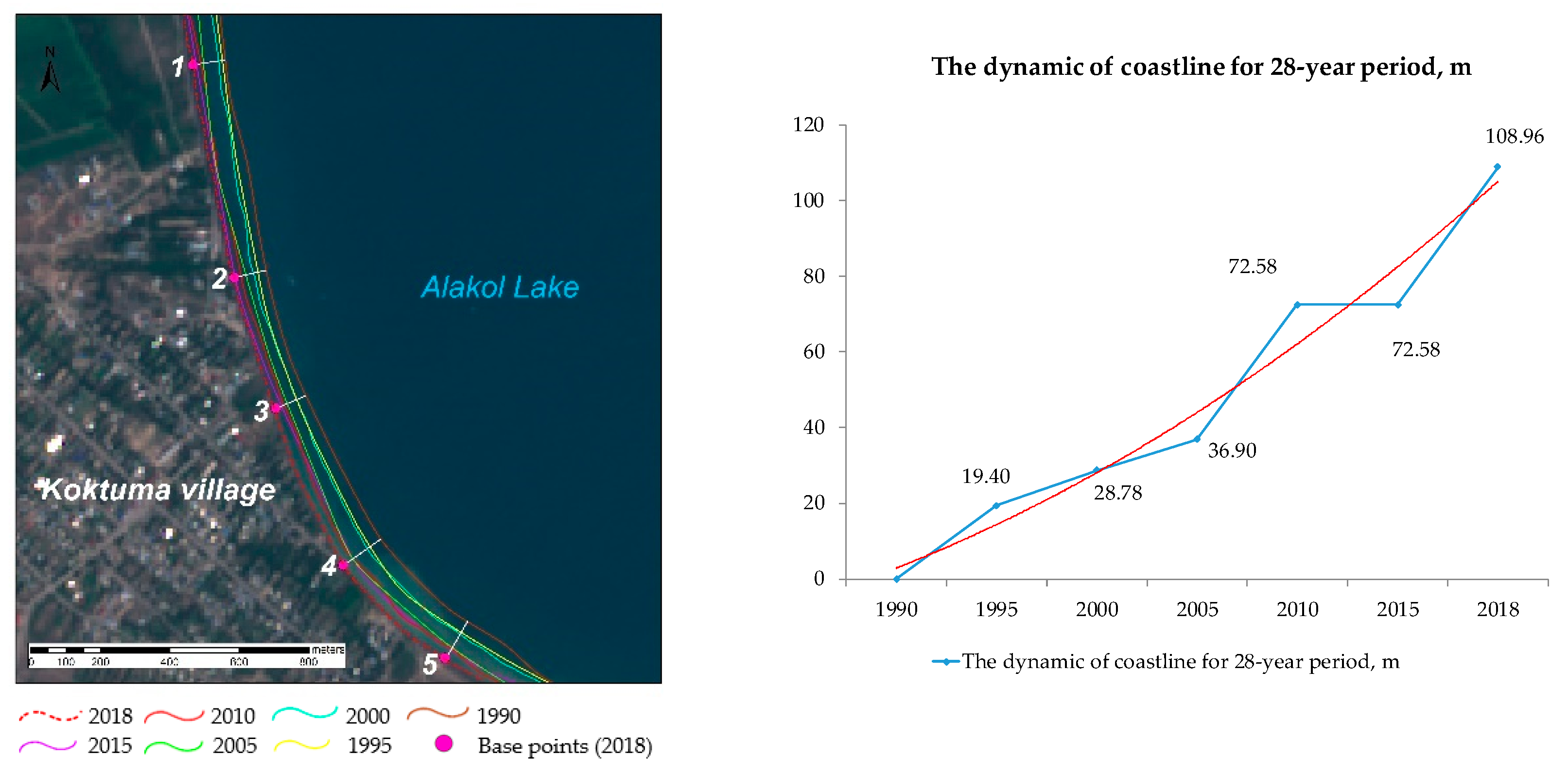
- Monitoring site No 1 in Koktuma village: the coast has a 6-meter long coastal ledge, which is prone to intensive abrasion processes. Over a period from 1990 to 2018, the coastline has moved forward in the western direction, on average, for more than 130 m throughout the entire coast, the most drastic changes occurred during the period from 2005 to 2010 (Figure 2, Table 4).
- ▪
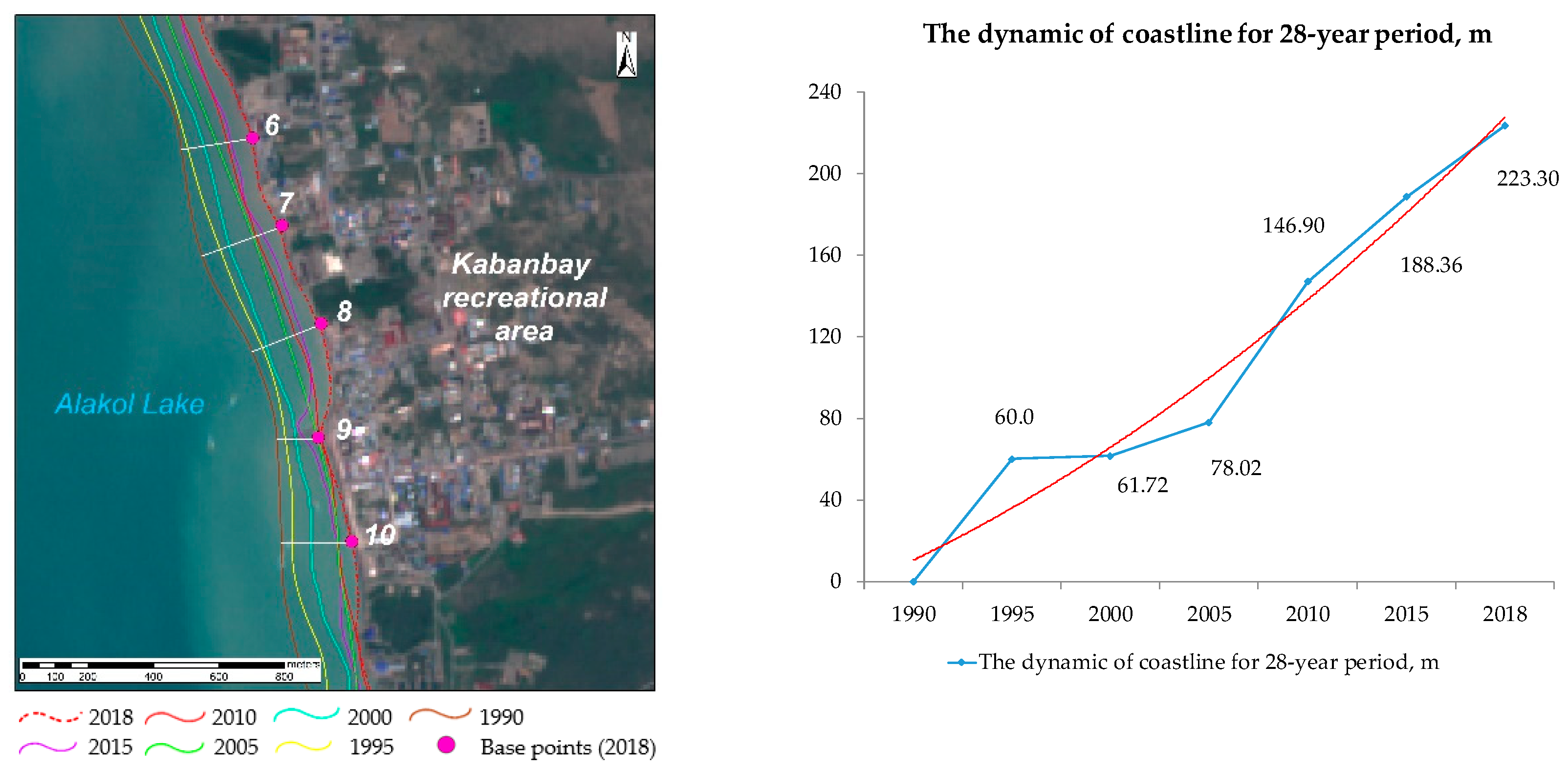
- Monitoring site No 2 in Kabanbai village: over the 28-year period, the dynamics of the lake flooding amounted to more than 200 m (Figure 3, Table 4). The study further found that the coastal zone in Monitoring site No 1 in Koktuma village and Monitoring site No 2 in Kabanbai village is faced with myriad and growing anthropogenic pressures. These anthropogenic pressures are further fueled due to growth in human populations and density along the coast. As illustrated in Figure 2 and Figure 3, most areas of coastal zone occupied by residential sector with recreational and agricultural activities.
- ▪
- ▪
4. Conclusions
Supplementary Materials
Author Contributions
Funding
Acknowledgments
Conflicts of Interest
References
- Mannig, B.; Müller, M.; Starke, E.; Merkenschlager, C.; Mao, W.; Zhi, X.; Podzun, R.; Jacob, D.; Paeth, H. Dynamical downscaling of climate change in Central Asia. Glob. Planet. Chang. 2013, 110, 26–39. [Google Scholar] [CrossRef]
- Karatayev, M.; Kapsalyamova, Z.; Spankulova, L.; Skakova, A.; Movkebayeva, G.; Kongyrbay, A. Priorities and challenges for a sustainable management of water resources in Kazakhstan. Sustain. Water Qual. Ecol. 2017, 9, 115–135. [Google Scholar] [CrossRef]
- Yapiyev, V.; Sagintayev, Z.; Inglezakis, V.; Samarkhanov, K.; Verhoef, A. Essentials of endorheic basins and lakes: A review in the context of current and future water resource management and mitigation activities in Central Asia. Water 2017, 9, 798. [Google Scholar] [CrossRef]
- Klein, I.; Dietz, A.J.; Gessner, U.; Galayeva, A.; Myrzakhmetov, A.; Kuenzer, C. Evaluation of seasonal water body extents in Central Asia over the past 27 years derived from medium-resolution remote sensing data. Int. J. Appl. Earth Obs. Geoinf. 2014, 26, 335–349. [Google Scholar] [CrossRef]
- Friedrich, J.; Oberhänsli, H. Hydrochemical properties of the Aral Sea water in summer 2002. J. Mar. Syst. 2004, 47, 77–88. [Google Scholar] [CrossRef]
- Yapiyev, V.; Samarkhanov, K.; Tulegenova, N.; Jumassultanova, S.; Verhoef, A.; Saidaliyeva, Z.; Umirov, N.; Sagintayev, Z.; Namazbayeva, A. Estimation of water storage changes in small endorheic lakes in Northern Kazakhstan. J. Arid. Environ. 2019, 160, 42–55. [Google Scholar] [CrossRef]
- Karthe, D. Environmental changes in Central and East Asian drylands and their effects on major river-lake systems. Quat. Int. 2018, 475, 91–100. [Google Scholar] [CrossRef]
- Salnikov, V.; Turulina, G.; Polyakova, S.; Petrova, Y.; Skakova, A. Climate change in Kazakhstan during the past 70 years. Quat. Int. 2015, 358, 77–82. [Google Scholar] [CrossRef]
- Chen, J.L.; Pekker, T.; Wilson, C.R.; Tapley, B.D.; Kostianoy, A.G.; Cretaux, J.F.; Safarov, E.S. Long-term Caspian Sea level change. Geophys. Res. Lett. 2017, 44, 6993–7001. [Google Scholar] [CrossRef]
- Huang, L.; Liu, J.; Shao, Q.; Liu, R. Changing inland lakes responding to climate warming in Northeastern Tibetan Plateau. Clim. Chang. 2011, 109, 479–502. [Google Scholar] [CrossRef]
- Micklin, P. The Aral Sea disaster. Annu. Rev. Earth Planet. Sci. 2007, 35, 47–72. [Google Scholar] [CrossRef]
- Zeng, H.; Wu, B.; Zhu, W.; Zhang, N. A trade-off method between environment restoration and human water consumption: A case study in Ebinur Lake. J. Clean. Prod. 2019, 217, 732–741. [Google Scholar] [CrossRef]
- Aghakouchak, A.; Norouzi, H.; Madani, K.; Mirchi, A.; Azarderakhsh, M.; Nazemi, A.; Nasrollahi, N.; Farahmand, A.; Mehran, A.; Hasanzadeh, E. Aral Sea syndrome desiccates Lake Urmia: Call for action. J. Great Lakes Res. 2015, 41, 307–311. [Google Scholar] [CrossRef]
- Rivotti, P.; Karatayev, M.; Mourão, Z.S.; Shah, N.; Clarke, M.L.; Konadu, D.D. Impact of future energy policy on water resources in Kazakhstan. Energy Strategy Rev. 2019, 24, 261–267. [Google Scholar] [CrossRef]
- Karatayev, M.; Rivotti, P.; Mourão, Z.S.; Konadu, D.D.; Shah, N.; Clarke, M. The water-energy-food nexus in Kazakhstan: Challenges and opportunities. Energy Procedia 2017, 125, 63–70. [Google Scholar] [CrossRef]
- Deng, H.; Chen, Y. Influences of recent climate change and human activities on water storage variations in Central Asia. J. Hydrol. 2017, 544, 46–57. [Google Scholar] [CrossRef]
- Filonets, P.; Omarov, T.R. Lakes of Central and Southern Kazakhstan; Alma-Ata: the Kazakh SSR Science: Almaty, Kazakhstan, 1973; p. 198. [Google Scholar]
- United States Geological Survey (USGS). The Earth Explorer (EE) Interface. Available online: https://earthexplorer.usgs.gov (accessed on 18 September 2019).
- Environment and Natural Resources. Available online: https://ingeo.kz/ (accessed on 18 September 2019).
- Korovin, V.; Kurdin, R.D. Alakol lakes level mode. Alakol depression and its lakes. Geogr. Issues Kazakhstan 1965, 12, 122–140. [Google Scholar]
- Bai, J.; Chen, X.; Li, J.; Yang, L.; Fang, H. Changes in the area of inland lakes in arid regions of central Asia during the past 30 years. Environ. Monit. Assess. 2011, 178, 247–256. [Google Scholar] [CrossRef]
- Bai, J.; Chen, X.; Yang, L.; Fang, H. Monitoring variations of inland lakes in the arid region of Central Asia. Front. Earth Sci. 2012, 6, 147–156. [Google Scholar] [CrossRef]
- Misra, A.; Balaji, R. A study on the shoreline changes and Land-use/land-cover along the South Gujarat coastline. Procedia Eng. 2015, 116, 381–389. [Google Scholar] [CrossRef]
- Li, X.; Zhou, Y.; Zhang, L.; Kuang, R. Shoreline change of Chongming Dongtan and response to river sediment load: A remote sensing assessment. J. Hydrol. 2014, 511, 432–442. [Google Scholar] [CrossRef]
- Qiao, G.; Mi, H.; Wang, W.; Tong, X.; Li, Z.; Li, T.; Liu, S.; Hong, Y. 55-year (1960–2015) spatiotemporal shoreline change analysis using historical DISP and Landsat time series data in Shanghai. Int. J. Appl. Earth Obs. Geoinf. 2018, 68, 238–251. [Google Scholar] [CrossRef]
- Behling, R.; Milewski, R.; Chabrillat, S. Spatiotemporal shoreline dynamics of Namibian coastal lagoons derived by a dense remote sensing time series approach. Int. J. Appl. Earth Obs. Geoinf. 2018, 68, 262–271. [Google Scholar] [CrossRef] [Green Version]
- Ghosh, M.K.; Kumar, L.; Roy, C. Monitoring the coastline change of Hatiya Island in Bangladesh using remote sensing techniques. ISPRS J. Photogramm. Remote. Sens. 2015, 101, 137–144. [Google Scholar] [CrossRef]
- Wang, X.; Liu, Y.; Ling, F.; Liu, Y.; Fang, F. Spatio-Temporal change detection of Ningbo coastline using Landsat time-series images during 1976–2015. Int. J. Geo-Inf. 2017, 6, 68. [Google Scholar] [CrossRef]
- Deus, D.; Gloaguen, R. Remote sensing analysis of lake dynamics in semi-arid regions: implication for water resource management. Lake Manyara, East African Rift, Northern Tanzania. Water 2013, 5, 698–727. [Google Scholar] [CrossRef]
- Feyisa, G.L.; Meilby, H.; Fensholt, R.; Proud, S.R. Automated Water Extraction Index: A new technique for surface water mapping using Landsat imagery. Remote. Sens. Environ. 2014, 140, 23–35. [Google Scholar] [CrossRef]


| Morphometric Characteristics | 1973 | 2018 |
|---|---|---|
| Lake area, km2 | 2650 | 3033.2 |
| Length, km | 104 | 104 |
| Width, km | 52 | 53.5 |
| Maximum depth, m | 54.0 | - |
| Volume of water mass, million m3 | 58,560 | 64,517 |
| Coastline length, km | 384.0 | 517.5 |
| Water-level (absolute m) | 347.3 | 351.1 |
| Water catchment area, km2 | 47,859 | - |
| Satellite Images | Sensor |
|---|---|
| LT05_L1TP_147028_19900606_20170130_01_T1 | TM |
| LT05_L1TP_147028_19950417_20170109_01_T1 | TM |
| LE07_L1TP_147028_20000727_20170210_01_T1 | ETM |
| LE07_L1TP_147028_20050623_20170115_01_T1 | ETM |
| LE07_L1TP_147028_20100808_20161213_01_T1 | ETM |
| LC08_L1TP_147028_20150830_20170405_01_T1 | OLI TIRS |
| LC08_L1TP_147028_20180705_20180717_01_T1 | OLI TIRS |
| S2B_MSIL1C_20180729T052639_N0206_R105_T44TLN_20180729T082025 | S2B |
| S2B_MSIL1C_20180726T072159_N0206_R063_T38LNR_20180726T104944 | S2B |
| Satellite | Resolution | Acquisition Date | Acquisition Time |
|---|---|---|---|
| Landsat-5 | 30 m | 06/06/1990 | 04:40:26 |
| Landsat-5 | 30 m | 17/04/1995 | 04:29:06 |
| Landsat-7 | 30 m | 07/27/2000 | 05:11:26 |
| Landsat-7 | 30 m | 23/06/2005 | 05:09:40 |
| Landsat-7 | 30 m | 08/08/2010 | 05:12:27 |
| Landsat-8 | 30 m | 08/30/2015 | 05:20:03 |
| Landsat-8 | 30 m | 07/05/2018 | 05:19:20 |
| Sentinel 2B | 10 m | 29/07/2018 | 05:36:55 |
| Sentinel 2B | 10 m | 29/07/2018 | 05:36:55 |
| Point | 1990 | 1995 | 2000 | 2005 | 2010 | 2015 | 2018 |
|---|---|---|---|---|---|---|---|
| Monitoring Site No 1 in Koktuma Village | |||||||
| 1 | 95.4 | 85.7 | 74.9 | 33.4 | 24.2 | 8.3 | 0 |
| 2 | 94.6 | 72.0 | 56.4 | 36.7 | 21.0 | 4.6 | 0 |
| 3 | 97.4 | 68.9 | 67.2 | 39.2 | 28.7 | 20.1 | 0 |
| 4 | 130.6 | 90.3 | 81.2 | 33.7 | 33.1 | 33.0 | 0 |
| 5 | 126.8 | 91.5 | 83.2 | 41.5 | 36.9 | 33.7 | 0 |
| Monitoring Site No 2 in Kabanbai Village | |||||||
| 6 | 226 | 206.8 | 159 | 114.7 | 78 | 68 | 0 |
| 7 | 272 | 217 | 177 | 89 | 86 | 64 | 0 |
| 8 | 259 | 218 | 182 | 121.7 | 88 | 63 | 0 |
| 9 | 145 | 118 | 89 | 20 | 15.6 | 67 | 0 |
| 10 | 217 | 182 | 127.5 | 44.7 | 41 | 38 | 0 |
| Monitoring Site No 3 in Delta of Katynsu River | |||||||
| 11 | 654 | 722 | 641 | 529 | 386 | 134 | 0 |
| 12 | 823 | 1059 | 810 | 851 | 718 | 421 | 0 |
| 13 | 954 | 984 | 797 | 923 | 638.5 | 280 | 0 |
| 14 | 743.5 | 714 | 672 | 728 | 492 | 224 | 0 |
| 15 | 864 | 903 | 891 | 879 | 716 | 295 | 0 |
| Monitoring Site No 4 in Kamyskala Village | |||||||
| 16 | 556 | 404 | 299 | 192.4 | 128 | 81 | 0 |
| 17 | 1200 | 292 | 270 | 267 | 156 | 151 | 0 |
| 18 | 760 | 120 | 106 | 64 | 57 | 57 | 0 |
| 19 | 830 | 435 | 61 | 15 | 251 | 550 | 0 |
| 20 | 339.5 | 256 | 240 | 153 | 131 | 249 | 0 |
© 2019 by the authors. Licensee MDPI, Basel, Switzerland. This article is an open access article distributed under the terms and conditions of the Creative Commons Attribution (CC BY) license (http://creativecommons.org/licenses/by/4.0/).
Share and Cite
Valeyev, A.; Karatayev, M.; Abitbayeva, A.; Uxukbayeva, S.; Bektursynova, A.; Sharapkhanova, Z. Monitoring Coastline Dynamics of Alakol Lake in Kazakhstan Using Remote Sensing Data. Geosciences 2019, 9, 404. https://doi.org/10.3390/geosciences9090404
Valeyev A, Karatayev M, Abitbayeva A, Uxukbayeva S, Bektursynova A, Sharapkhanova Z. Monitoring Coastline Dynamics of Alakol Lake in Kazakhstan Using Remote Sensing Data. Geosciences. 2019; 9(9):404. https://doi.org/10.3390/geosciences9090404
Chicago/Turabian StyleValeyev, Adilet, Marat Karatayev, Ainagul Abitbayeva, Saule Uxukbayeva, Aruzhan Bektursynova, and Zhanerke Sharapkhanova. 2019. "Monitoring Coastline Dynamics of Alakol Lake in Kazakhstan Using Remote Sensing Data" Geosciences 9, no. 9: 404. https://doi.org/10.3390/geosciences9090404
APA StyleValeyev, A., Karatayev, M., Abitbayeva, A., Uxukbayeva, S., Bektursynova, A., & Sharapkhanova, Z. (2019). Monitoring Coastline Dynamics of Alakol Lake in Kazakhstan Using Remote Sensing Data. Geosciences, 9(9), 404. https://doi.org/10.3390/geosciences9090404