Article

Study on Early Warning Method for Water Inrush in Tunnel Based on Fine Risk Evaluation and Hierarchical Advance Forecast

1
Geotechnical and Structural Engineering Research Center, Shandong University, Ji’nan 250061, China
2
School of Civil Engineering, Yangtze Normal University, Fuling, Chongqing 408100, China
*
Authors to whom correspondence should be addressed.
Geosciences 2019, 9(9), 392; https://doi.org/10.3390/geosciences9090392
Submission received: 27 June 2019 / Revised: 25 August 2019 / Accepted: 4 September 2019 / Published: 7 September 2019

Abstract

:
Water inrush is one of the most frequent and harmful geological disasters in tunnel construction. In order to effectively prevent and control the occurrence of water inrush, an early warning method based on fine risk evaluation and hierarchical advanced forecast is proposed. Water inrush is a complex dynamic coupling factors system, the relationship between influencing factors and water inrush is strongly nonlinear. Therefore, the efficacy coefficient model, which has the advantages of standardization, conciseness, and freedom from subjective factors, is improved nonlinearly. The fine risk evaluation theory and method based on the improved efficacy coefficient model consisted of two parts: one is static evaluation used in design stage, and the other is dynamic evaluation applied in the construction stage. The index weights are determined scientifically and reasonably by Analytical Hierarchy Process (AHP) and the entropy method. According to the fine risk evaluation results, combined with the advantages and disadvantages of various forecasting methods, a multistep hierarchical detection method of disaster resources for water inrush is proposed to identify the occurrence characteristics and failure level of disaster sources. The theory has been successfully applied to the #3 inclined well of Yuelongmen Tunnel in Cheng-Lan Railway. The evaluation results had good agreement with the actual excavation data, which indicates that the model is of high credibility and feasibility. The method could improve the prediction accuracy of water inrush and explore geometric characteristics and filling of disaster-causing structures. It is of great significance for avoiding water inrush and guiding the rapid and safe tunnel construction.

1. Introduction

According to the national strategy layout of “One Belt and One Road”, more and more tunnels will be built in the western mountain areas of China with developed karst, rich groundwater and surface water, and extremely complex geological conditions. Water inrush is easily induced in tunnel construction, resulting in serious casualties and huge economic loss. Now, water inrush hazard has become one of the major geological calamity of constraining the development of tunnel construction in the Karst area [1,2,3]. According to incomplete statistics, water and mud inrush and its induced geological disasters, which has caused serious harm to life, property, and the environment, have accounted for more than 50% of major safety accidents in the tunnels [3,4,5]. Therefore, study on early warning for water inrush is the most effective ways to avoid and prevent the geological disaster.
A number of scholars have carried out research on water and mud inrush. Their focus of early warning was mainly on risk evaluation and advanced prediction. Li et al. [6,7,8] proposed an evaluation method of water inrush risk based on the attribute synthetic model in karst tunnels. Li et al. [9] analyzed the disaster-related environmental factors and disaster-causing factors of water inrush and established a FAHP risk evaluation model of water inrush in karst tunnels. Li et al. [10] used a modified grey clustering method and a comprehensive weight assignment method to systematically evaluate the risk of water inrush in karst tunnels. Wang et al. [11] selected economic and cost indices as the evaluation indices of water inrush, and used the SPA Set Pair Analysis (SPA) model to calculate graded connection degrees of evaluation indices. Hao et al. [12] proposed a methodology based on the geo-mechanical model and quantification model of margins and uncertainties to evaluate the risk of water inrush. Wang et al. [13] proposed a weighting method combining the analytic hierarchy process, entropy method, and statistical methods, and established a new assessment method based on the normal cloud model. With the wide application of computers in risk assessment, Bukowski [14] proposed a risk assessment system based on inflow intensity and the amount of suspended material. Li et al. [15,16] developed an assessment system based on Fuzzy Analytical Hierarchy Process (FAHP) to realize the dynamic assessment of water inrush. In addition, advanced geological prediction is a common method to realize the early warning of water inrush. The single geophysical method, whose forecast accuracy is very low due to multiple solutions, is often used for karst exploration [17,18]. SC Li et al. [19,20] put forward the concept of joint exploration of various geophysical prediction methods and carried out field tests. However, the method cannot be widely promoted in construction due to high cost and time-consumption.
In light of the above problems, an early warning method based on fine risk evaluation and hierarchical advanced forecast was established. First, the improved efficacy coefficient model was introduced into the fine risk evaluation of water inrush in a tunnel. The efficacy coefficient method is widely applied to early warning of tunnel surrounding rock instability and debris flows and the classification prediction of rock burst intensity, which has the characteristics of standardization, conciseness, and freedom from various subjective factors efficacy [21,22]. However, there is a complex nonlinear relationship between water inrush and influencing factors. The traditional method assumes that the relationship is linear. Therefore, the efficacy coefficient model is improved nonlinearly. Then, according to the evaluation results and characteristics of various forecasting methods, the multi-step hierarchical advanced prediction method was established to realize fine exploration and decision-making for disaster-causing structures.

2. Improved Efficacy Coefficient Method

The efficiency coefficient method is a linear multi-attribute and multi-objective comprehensive evaluation method. First, the satisfied value and the non-permitting value of each evaluation index are ascertained for same metrization. Then, the efficacy coefficient value of a single index is calculated by specific formulas. Subsequently, the comprehensive efficacy coefficient value is determined by superposing the single-index’s value, considering the weight, with the purpose to evaluate the potential risk grade of the objects.

2.1. Efficacy Coefficient Value of Single Index

The traditional efficacy coefficient model depends only on the total efficacy coefficient value to judge the risk grade. Therefore, the evaluation indexes selected from key factors are opposite and complementary. However, the factors are interrelated, which is difficult to make completely independent. In order to eliminate the impact of the indexes’ repeatability on the evaluation results, each evaluation index is assigned a single-index’s efficacy coefficient value corresponding to all risk levels in Equation (1). According to the above equation, the efficacy coefficient value of the most possible risk grade is the smallest. To meet the maximum membership degree principle, the negative efficacy coefficient value is presented as shown in Equation (2). Furthermore, the positive efficacy coefficient matrix D+ and negative efficacy coefficient matrix D are established.
d i j + ( x ) = | X i j u X i X i j u X i j l |
d i j ( x ) = | X i X i j l X i j u X i j l |
D+ = [dij+]n×m
D = [dij]n×m
where dij+(x) and dij(x) are the positive and negative efficacy coefficient value of ith evaluation index corresponding to jth risk grade, respectively. XijU and Xijl are the interval upper limit value and lower limit of the ith evaluation index, corresponding to the jth risk grade. Xi is the measured value of the ith evaluation index.

2.2. Multi-Index Efficacy Coefficient Value

In the traditional method, the multi-index efficacy coefficient value is a linear superposition of single-index’s efficacy coefficient value coupled with the weight. Water inrush is a complex non-linear dynamic geological phenomenon and its influence factors are non-independent and interacted. When all factors are not beneficial to safety, water inrush is more likely to occur. Conversely, the more favorable the factors are to safety, the less likely the disaster will occur. In order to reflect this rule, the positive efficacy coefficient value and negative efficacy coefficient value of single index are squared. Then, the positive and negative multi-index efficacy coefficient value can be obtained by coupling of the single-index efficacy coefficient value and the weight in Equations (5) and (6).
C j + = i = 1 n w i ( d i j + ) 2
C j = i = 1 n w i ( d i j ) 2
where wi is the comprehensive weight value of ith evaluation index, and i = 1 n w i = 1 needs be satisfied.

2.3. Risk Grade Recognition

In order to meet the maximum membership degree principle, the total efficacy coefficient value p is defined as the size of membership degree corresponding to every risk grade, as shown in Equation (7).
p j = C j + C j + + C j
where 0 ≤ pj ≤ 1. When pj is the maximum, the object belongs to the jth risk grade.

2.4. Combination Weight

The evaluation result can be directly affected by the weight in the efficacy coefficient method [21]. The combination assigning method, composed of the objective weight determined by the entropy method, and the subjective weight, determined by Analytic Hierarchy Process (AHP), are adopted to ensure that the weight can accurately reflect the importance degree of the evaluation indexes.
W = k 1 W 1 + k 2 W 2
where W1 is the objective weight vector and W2 is the subjective weight vector. k1 and k2 are the distribution coefficient of W1 and W2, which are determined by expert experience.

2.4.1. Entropy Method

As a measure of the disorder degree on a thermodynamics system, entropy can vividly describe the amount of useful information provided. The more effective information that each index has, the bigger the entropy is. It can avoid the subjective interference by using the entropy method, which is caused to determine the weight of every factor. For this reason, the entropy method was adopted to determine the objective weight of the water inrush indexes. The specific steps are as follows:
Step 1: The original matrix B = (bij)m×n is established by selecting m sample of water inrush during tunnel construction and n evaluation indexes. Then, the matrix R = (rij)m×n is obtained through normalization processing of original matrix B.
Step 2: Based to the concept, the entropy of evaluation indexes is determined.
H j = 1 ln m i = 1 m f i j ln f i j
f i j = r i j i = 1 m r i j
Step 3: The calculation formula of entropy weight wj is as follows:
w j = 1 H j n j = 1 n H j
where wj satisfies j = 1 n w j = 1 .

2.4.2. Analytic Hierarchy Process (AHP)

The AHP was put forward by T.L. Saaty in the 1970s, whose advantage is that the complex problems are simplified as interrelationship among elements by making full use of the experts’ subjective initiative. According to the importance degree among indexes, the 1–9 scale method is adopted to construct n order judgment matrix denoted by M = (mij)n×n (n represents the number of risk evaluation factors), where mij expresses the importance degree between Ii and Ij.
Based on the judgment matrix, the steps for solving the weight of indexes are as follows:
W = ( w 1 , w 2 , , w n )
where W is the indexes’ weight vector, and wi (i = 1, 2, …, n) represents the weight of ith index.
w i = w i ¯ i = 1 n w i ¯
where w i ¯ is geometric average value of ith index.
w i ¯ = j = 1 n m i j n ( i = 1 , 2 , , n )
The fundamental approaches of simulation credibility research are through static and dynamic consistency tests between the simulation and practical test results.
When the consistency check of the initial weight value solved is carried out, the formulas are as follows:
λ max = 1 n i = 1 n ( M W ) i w i
where λmax represents the maximum eigenvalue of the eigenvector.
C I = λ max n n 1 ,   C R = C I R I
where CI represents the consistency index and RI represents the mean random consistency index, which takes its value from [23]. CR expresses the coincidence coefficient. When CI and CR are less than 0.1, the judgment matrix satisfies the consistency check.

3. Fine Risk Evaluation Method of Water inrush

In order to realize the accurate prediction of water inrush risk in karst tunnels, a new risk evaluation theory and method based on improved efficacy coefficient model was proposed. The theory consists of the static evaluation model, which is used to provide evidence for tunnel design, and the dynamic evaluation model, which is applied to provide guidance for safe construction. The risk grade of water inrush is determined to effectively realize early warning, combined with the interpretation result of the regional refined advanced forecasting methods [4].
The evaluation index system is very important for the risk evaluation theory and method. The reasonableness of the evaluation index directly affects the accuracy of the evaluation results. However, the influencing factors of water inrush in karst tunnels is very complex and various. According to the previous research results, the influencing factors can be categorized into disaster-related environment factors and disaster-causing factors [6,13,16]. Since the static evaluation occurs in the design stage, the disaster-related environmental factors were selected as evaluation indexes. The dynamic evaluation happens in the construction stage, so disaster-causing factors were added to the dynamic evaluation index system.

3.1. Static Evaluation

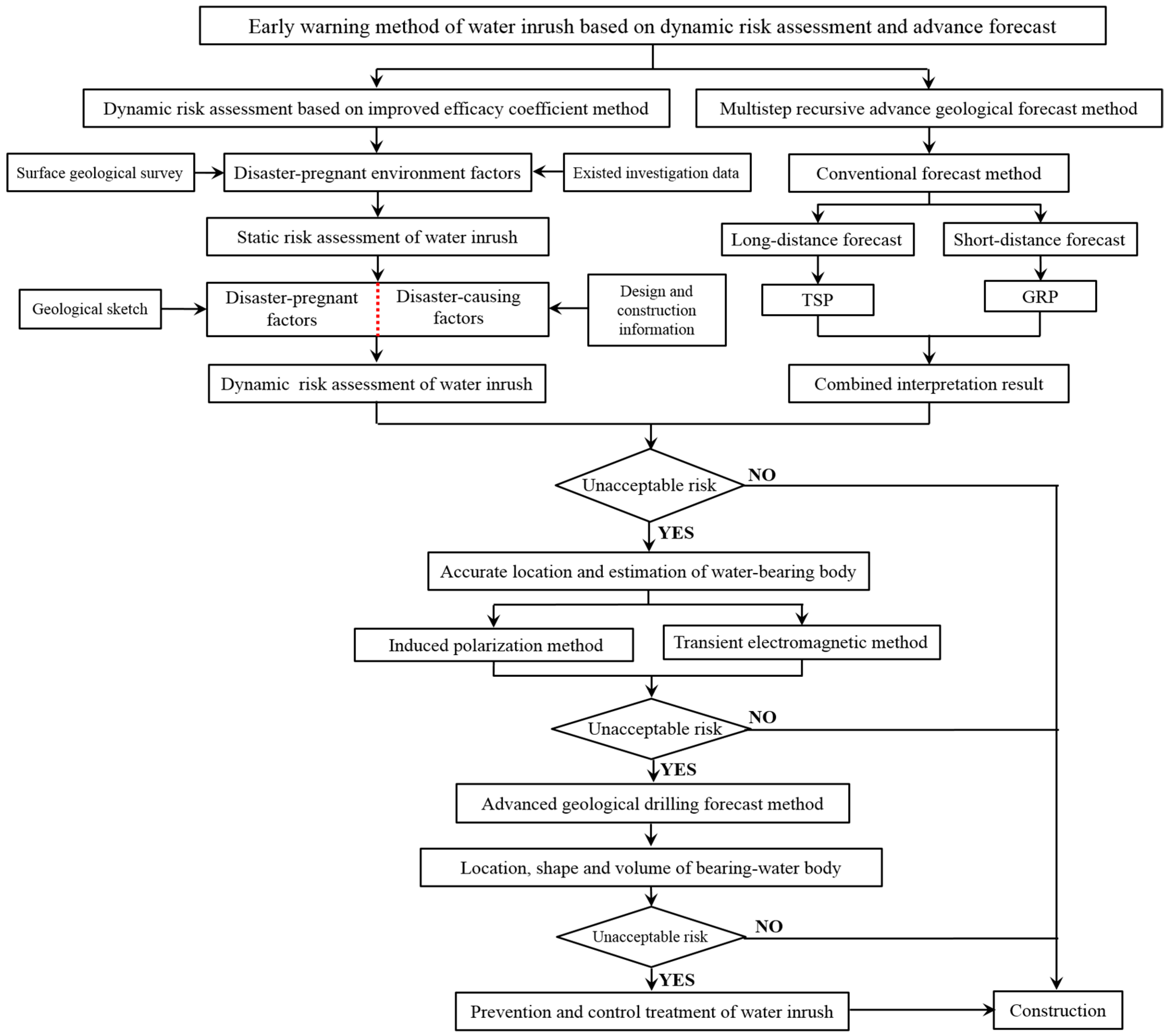
Static evaluation occurs before the design and after the geological survey. It is used for the preliminary water inrush risk assessment of the whole tunnel based on the improved efficacy coefficient method and disaster-related environmental evaluation indexes. Therefore, the quantification of disaster-related environmental indexes mainly depends on karst hydrogeology data obtained by geological investigation. The evaluation results are submitted to the design unit in the form of a report, which can provide the basis for design. In the process of design, some measures including pre-grouting and changing excavation method, and so on, are taken to control the occurrence of water inrush for unacceptable risks.

3.1.1. Disaster-Related Environmental Factors

Stratum lithology F1; attitude of rocks F2; bad geology F3; groundwater level F4; topography and geomorphology F5; contact zone of dissolvable and insoluble rocks F6; and layer and interlayer fissures F7 were selected as the static evaluation indexes.
(1) Stratum lithology F1
The basic reason that formation is the material base for karst development is the corrosion ability of rock influenced by mineral composition, rock microstructure, geological structure, and other factors. This is also the reason for the difference in karst development of different rock formations. The results show that the higher the mineral content of carbonate, sulfate, and halogens without considering the effect of groundwater, the more conducive the enrichment of water and karst development. The influence of rock structure on dissolved-erosion is that it can change the permeability of the rock mass. In general, the thicker the single homogeneous soluble rocks are, the easier it is to develop karst spaces such as large caves and caverns. Therefore, stratum lithology is divided into a strong karst layer, middle karst layer, weak karst layer, and non-karst layer, according to corrosion ability (Table 1). The carbonate content was used to describe index F1 because carbonate content is the main controlling factor in determining the corrosion ability of soluble rock.
(2) Attitude of rocks F2
The attitude of rocks plays an important effect on karst development. In general, the steeper the strata, the more conducive it is to develop the joints and fissures that provide the limited pathway for groundwater moving and the formation of surface water. Conversely, the horizontal strata are not conducive to the flow and storage of water due to weak developed joints and fissures. However, the greater the strata inclination, the more unfavorable it is to gather surface water, and the slower the karst development rate is. The results show that 25–65° is the most conducive to karst development, and the division criterion was determined by analyzing the relationship between water inrush and the attitude of rocks [9,24].
(3) Bad geology F3
Bad geology is one of the important factors to induce water inrush. In a karst tunnel, bad geology refers to water bearing structure and water conductive structures in the tunnel site and around including water-filled cave, karst conduct, underground river, fault fracture zone, and fractured zone. The tectonic stress concentration phenomenon produced by tensile, torsion, and extrusion of complex tectonic movement makes soluble strata loose and fractured. At this time, the permeability of rock mass is obviously increased, which is favorable to the migration of ground water and karst development. Therefore, the soluble strata with the fault and fissures is usually pregnant with large caves and other harmful geological structure, which greatly increase the possibility of water inrush (Table 2).
(4) Groundwater level F4
Groundwater is the essential element and power source of water inrush. Water inrush risk in a tunnel that is located in different karst hydrodynamic vertical zoning is different According to the effect of hydrodynamics on karst, the groundwater flow has vertical zonation, and according to the influence degree of karst hydrodynamics on karst development, it is divided into the surface zone, unsaturated zone, seasonal variation zone, shallow saturation zone, and pressure saturated zone from top to bottom. As the chemical activity and physical activity of the seasonal variation zone between flood level and low water level are the strongest, large cavities, non-filling karst pipeline, and other water conducting structures are easily developed. When heavy rainfall happens, the possibility of water inrush is very high. The shallow saturation zone below the constant water level has the perennial circulation of water flow with strong dissolution ability and erosion ability, where some large water-filled caverns and puddles are easily developed. Therefore, it is very easy to cause large water inrush. The deep saturation zone and siphon zone are together called the pressure saturated zone [25]. Due to the weak groundwater dynamics, the karst development in the zone is weaker than that in the shallow saturated zone. However, once water inrush occurs, the characteristics of high water head and pressure make the risk more harmful.
The deeper the karst water vertical zoning, which the tunnel goes through, the greater the risk of water inrush. Therefore, it is more scientific to use the difference between annual maximum groundwater level and tunnel floor elevation to characterize the danger of water inrush. According to the construction experience and the collected data of previous water inrush, the groundwater heads higher than 60 m above the tunnel floor are classified as risk grade R1, which has rapid instantaneous speed and the amount of water inrush. The groundwater heads 30 m < h < 60 m are classified as risk grade R2, which is second only to grade R1. The heads 10 m< h < 30 m are classified as risk grade R3. The seepage and erosion process of fine-grained filling material caused by the heads is so slow that the sudden occurrence is greatly weakened. The heads 0 m< h < 10 m, classified as grade R4, is the lowest risk level, which generally cannot cause water inrush.
(5) Topography and geomorphology F5
The research results show that the development of underground karst structures is controlled by surface karst shapes. When karst depression, trough valley, funnel, doline, and other catchment structures are developed in the surface, the underground strata often develops some bad geological bodies including caves, karst pipelines, and underground rivers. This is because the catchment and infiltration of surface water are the biggest recharge source to groundwater hydrodynamic circulating system. The precipitation and surface pond are recharged into groundwater, which is endowed with strong scour mechanical energy and erosion chemical energy through surface karst forms. Consequently, the more developed the surface karst shapes are, the better the catchment capacity is, and the more favorable it is to the development of underground karst structures. In order to facilitate the quantification of the index in risk assessment, the topography and geomorphology F5 is described by the ratio of the closed negative terrain area in the surface [24].
(6) Contact zone of dissolvable and insoluble rocks F6
The contact zone of dissolvable and insoluble rocks is an interface to control the karst development. As a groundwater aquiclude, the poor permeability of non-soluble rock makes groundwater move inside the soluble rocks, which are far more permeable than non-soluble rocks, so the soluble rocks corrode. Moreover, the non-soluble rocks can collect the water from surface and external recharge, and make groundwater flow along the interface. Finally, a water-rich hydrodynamic circulation system, which is conducive to the development of large-scale karst structures, is formed.
(7) Layer and interlayer fissures F7
The layer and interlayer fissures F7 are also one of the important factors that affect the karst development. On one hand, the wider the fracture width is, the better the permeability, and the more active the groundwater is. On the other hand, the expansion of the fissure can further accelerate the water cycle. The large-scale karst structures are developed with the passage of time. Conversely, the karst development is weak in the zone of intact rock mass and weak fracture.

3.1.2. Grade Criteria of Disaster-Related Environment Factors

Based on the above analysis, the grade criteria of disaster-related environment factors for static evaluation of water inrush are shown in Table 3.

3.2. Dynamic Evaluation

Due to the restriction of the geotechnical investigation technique, the geological and hydrological conditions are inevitably fuzzy, which leads to a certain deviation in the static evaluation results. However, a part of the tunnel surrounding rock has been exposed by excavation, and the conditions further clarified in the process of dynamic evaluation. Therefore, the value of disaster-related environmental factors is modified according to revealed hydro-geological conditions. Meanwhile, the disaster-causing factors are added to the evaluation index system, and their values are determined by expert grading, based on the data of the design, construction, and weather. The risk grade of water inrush is revised to guide the safe construction.

3.2.1. Disaster-Causing factors

The construction factors are the direct cause to induce tunnel water inrush, mainly including design parameter F8, construction level F9, and atmospheric precipitation F10.
(1) Design parameter F8
The tunnel is designed according to geological survey and engineer experience. When the depth, length, support strength, and other design parameters are unreasonable, the probability of water inrush will increase. With the increase of tunnel depth, the water enrichment enhances and the water head gradient becomes bigger. If a rupture channel is formed, the hazardous harm is greater. The longer the tunnel in the karst area is, the more complex the geological unit where the tunnel goes through, and the more likely it is to encounter bad geology. The reason why the support parameters affect water inrush is that the sections of developing bad karst geology without support reinforcement and the change of excavation method will increase the probability of water inrush owing to the fuzziness of the geological survey along the way due to limited exploration techniques.
(2) Construction level F9
The construction level is the most direct cause of inducing water inrush. First of all, the stress concentration caused by the excavation can destroy the original seepage path of the groundwater and cause the expansion of original fissures and the development of new fissures inside the rock mass, which reduce the effective thickness of the protrusion prevention structure and accelerate the circulation of water. Support time, blasting disturbance control, construction management, and technology depend on the comprehensive strength of the construction unit. The unit that has good construction technology, advanced management, rich experience, and complete equipment can avoid the occurrence of geological hazards during tunnel construction.
(3) Atmospheric precipitation F10
The effect of atmospheric precipitation on water inrush is divided into long-term effect and short-term effect. The long-term effect is that the dissolution capacity of water is strong and the dissolution rate of soluble rocks is fast, which are conducive to the development of large karst structures. On the contrary, when the temperature is low and the rainfall is less, the karst development in the region is weak. The short-term effect is that instantaneous strong rainfall or long-time continuous rainfall can be transformed into groundwater through the surface karst shapes. The groundwater level rapidly rises and water pressure increases. Meanwhile, the water flow will carry a large amount of mud and sand. The water inrush is very likely to happen. Among them, the short-term effect of atmospheric precipitation, which has greater influence on water inrush, is mainly considered.

3.2.2. Grade Criteria for Disasters-Causing Factors

Due to various contents of the evaluation index comprehensively considered, the disaster-causing factors are easy to be qualitative and difficult to be quantitative. According to the qualitative description, the grade criteria of disaster-causing factors were determined and the expert scoring method was adapted to quantify the index (Table 4).

3.3. Regional Refined Advanced Forecast Methods

The advance geological forecast is an effective method to realize the exploration of bad geological bodies along the tunnel. Due to differences of a physical basis, every advance geological forecast method has a different identification capability for bad geological bodies. Therefore, a multistep recursive advance forecast method integrated by long distance with short distance and regional-local refinement exploration is proposed to reduce the multiplicity of solutions and improve the reliability of the detection results. In the process of interpretation, the above method can play a role of mutual combination, mutual verification, mutual complementation, and mutual restraints [17].

3.3.1. Advance Geological Forecast Method for Tunnel

Today, the existing advance geological forecasting of tunnels at home and abroad mainly includes the advance drilling method (advance heading, testing tunnel, advance drilling, etc.), seismic wave method (Tunnel Seismic Prediction (TSP), Tunnel Reflection Tomograpgy (TRT), Horizontal Seismic Profiling (HSP), seismic negative apparent velocity method, land sonar method, etc.), electromagnetic method (Ground Penetrating Radar (GPR), transient electromagnetic method, etc.), direct current method (induced polarization method, high density resistivity method, etc.), and other methods (Nuclear Magnetic Resonance (NMR) method, infrared water detecting method, thermal detecting method, etc.). Each kind of detection method is based on a certain property difference (such as elastic property, conduction property, heat conduction property, etc.) of geologic media, so each kind of forecast method has its own scope of application, sensitive properties, advantages and disadvantages (Table 5).

3.3.2. Multistep Hierarchical Advance Forecast Method

In order to realize the rapid and safe construction of karst tunnels, the effective prediction and early warning of water inrush is particularly critical. Therefore, the comprehensive prediction method combining long distance (TSP) and short distance (GRP) as a routine has been widely used to identify the geological situation in front of the tunnel face. When a geological anomalous body is inferred by the combined interpretation or the dynamic evaluation result of water inrush is unacceptable risk, transient electromagnetic method and induced polarization method, which are sensitive to water, are used to detect the location, shape, and scale of the disaster-causing structure. If there are still large geological anomalous bodies or the serious water inrush is very likely to occur in front of the tunnel face, the advance borehole drilling method is selected to recognize the filling characteristic and static reserve of the water-bearing body, and the concrete flow is shown in Figure 1. The multistep hierarchical advance forecast method can not only avoid the multiplicity of solutions for a single method and realize complementary advantages, but also reduces the interference to construction.

3.3.3. Risk Aversion Criteria for Water Inrush

It is very difficult to avoid water inrush completely in the construction of tunnels and underground engineering, which are built in a developed karst area. According to the qualitative damage degree of every risk grade, the risk acceptance criterion is formulated to judge whether the risk is acceptable or not. The water inrush risk that will certainly cause casualties, property loss, or construction delay, is defined as non-acceptance risk. The risk that is likely to cause casualties, property loss, or construction delay is defined as unacceptable risk. Risk that has a small impact on construction and safety of life and property is defined as acceptable risk. The detailed division is shown in Table 6.

4. Engineering Application

Yuelongmen Tunnel, of the Chenglan Railway, passes through the NE-extended Longmen Mountains. Within this area, there are numerous ridges and peaks with great differences in the height of hypsography, the valleys are narrow, the slopes are steep, the deep cutting erosion of the river is intense, and the shape of the river valley shows a “V” form. The complex topography and geomorphology are divided into middle mountain landforms and high mountain landforms. The tunnel is located in the Longmenshan tectonic belt, and crosses the Longmenshan central fault belt, which is a strongly active Holocene fault belt. The width of the faulted bedrock fracture zone varies from several meters to hundreds meters. On both sides of the main fault are the Guangtongba fault, Gaochuanping fault, Qianfoshan fault and F1, Tuzhumiao branch fault, and other secondary branch faults. The survey area develops several rivers that are mainly intermountain gully water with perennial flowing water that is recharged by meteoric water. The precipitation is mainly concentrated in 5–9 months, mostly in the form of heavy and torrential rain. Several folds and faults develop in the tunnel area to make the rock mass very fragmented. The local carbonatite area, contact zone of dissolvable and insoluble rocks, fault fracture zones, and core of folds with rich water are dangerous zones for water and mud inrush in tunnels.

4.1. Dynamic Risk Evaluation Result

Due to the limited space, the #3 inclined shaft XI3K0 + 396 of Yuelongmen Tunnel was selected as the case study. Based on the geological investigation data at the prospecting stage, it was inferred that the surrounding rock is aphanitic, mid-thick bedded light-grey and grey limestone intercalated by argillaceous limestone and dolomite, which were determined to be weak and medium soluble rock. There was a compressional fault with a large width of influencing zone and made jointed and fractured rock masses develop. The surface developed a river with perennial flowing water, and the difference between the groundwater level and tunnel floor was about 150 m. The measured value of the disaster-related environmental factors are shown in Table 7. When the construction reached XI3K0 + 396, according to a geological sketch of the tunnel face, the surrounding rock was a hard limestone of the Cambrian Qingping group, which was determined as weak soluble rock. The characteristic of the fault zone was so obvious that joint fissures strongly developed to make the rock mass integrity more broken than that achieved by the initial investigation. According to the design and construction information, the design unit and construction unit were the China Railway Eryuan and China Railway 19th bureau, respectively.
The objective weight was solved by the entropy method through the statistics of typical cases of water and mud inrush at home and abroad, and the subjective weight was determined by AHP. The combined weight can be obtained according to Equation (8). The dynamic risk evaluation of water and mud inrush in the tunnel was carried out based on the improved efficacy coefficient method (Table 7 and Table 8). By computing, the static evaluation result was Grade R1, and the dynamic evaluation result with the correction was also Grade R1. By comparing the results evaluated by the improved efficacy coefficient method with those of fuzzy mathematics, attribute mathematics, and extension theory, the results showed that good application effects had been achieved (Table 9). In addition, the ranking of membership degree R1 > R2 > R3 > R4 was regular, and the ranking of the membership degree calculated by other methods was disordered. This proved that the suggested method was more scientific and reasonable.

4.2. Advance Forecast Results

4.2.1. Conventional Advance Forecast Method

SIR3000 GPR was used to detect the range XJ3K0 + 393~XJ3K0 + 368 (25 m) in the way of two measuring lines. In order to ensure detection accuracy, the antenna was pressed against the tunnel face flattened before implementation. The radar was moved from the left side to right side in uniform motion during implementation when the phenomena of disengaging, stagnation, and sudden drive were avoided as far as possible. The velocity and the position of the two lines remained consistent.
By synthetically comparing the interpretation results of line 1 and line 2, it was inferred that the section XJ3K0393~XJ3K0373 had factures that developed and was rich in fissure water, which may induce water inrush (the detection results are shown in Figure 2).

4.2.2. Accurate Location and Estimation of Water-Bearing Bodies

(1) Induced polarization method
The location and size of the low resistance abnormity area were predicted according to the apparent resistivity and half decay time and other parameters collected by using the induced polarization instrument developed by Shandong University. The 3D image is shown in Figure 3.
By analyzing the difference of half decay time and low resistance abnormity area, it was inferred that the section XJ3K0 + 393~XJ3K0 + 380 (resistivity 50 Ωm), and the left and middle section XJ3K0 + 379~XJ3K0 + 363 (resistivity 70 Ωm) may conceal an underground watercourse and rich fissure water.
(2) Transient electromagnetic method
Canada proTEM47HP was selected to detect the geological condition. Considering the complex electromagnetic environment of the tunnel, the center-loop device was adopted to detect by point measurement. As the shallow layer of detection range is a blind area mentioned in the paper, the data of XJ3K0 + 390~XJ3K0 + 346 were analyzed. According to the apparent resistivity contour lines, it is inferred that the joint fissures developed with rich water in the sections of XJ3K0 + 388~XJ3K0 + 383, middle XJ3K0 + 378~XJ3K0 + 358, and right XJ3K0 + 358~XJ3K0 + 346.
Based on the detection results (Figure 4), the water-bearing structure was fractured with rich water, which was mainly focused on 0–10 m and the middle 14–30 m in front of the face during tunneling. There were geophysical abnormal bodies that were likely to induce large-scale geological hazards of water inrush. Therefore, advance geological drilling was carried out to further ascertain the situation of water-bearing bodies.

4.2.3. Advance Borehole Drilling Method

The C6 type’s multi-function hydraulic rock drilling rig was used to carry out advance geological drilling. According to the results of early prediction interpretation, four boreholes, whose locations are shown in Figure 5, were set up and the field drilling characteristics of every pipe 2 m long as a unit were described in detail (Figure 6).
(1)
#1 borehole: Only water gushed out from the pipe core in #1 borehole’s 6–8 m section, and jet distance was about 1 m long. The drilling eventually ended due to sticking.
(2)
#2 borehole: The jet length of water pressure was about 1 m from 2 m to 6 m in front of the face. Subsequently, serious sticking resulted in drilling stopping.
(3)
#3 borehole: The water pressure increased from 12 m in front of the face, and to 22 m, the jet distance could reach 4 m long. Finally, the drilling was stopped due to too high pressure.
(4)
#4 borehole: There was no large water pressure during drilling, and only a 0.3 m water column was ejected from 8 m to 10 m in front of the face.
No penetration of drill pipes was found in the process of drilling. According to field records, it can be inferred that the surrounding rock is broken and the crannies have developed full of high hydraulic pressure in the lower-left part of XJ3K0 + 387~XJ3K0 + 385, in the top-left part of XJ3K0 + 391~XJ3K0 + 387, and in middle part of XJ3K0 + 381~XJ3K0 + 371. However, the water content on the right hand was poor. Analysis indicated that cracks in surrounding rocks developed with very good connectivity to groundwater in the left and middle part of the work face.
According to the dynamic evaluation results of water inrush and the interpretation results of advance geological forecast methods, it was concluded that large water inrush is very likely to occur in the section. At 3:30 p.m. on 14 March 2015, a large amount of water gushed out of the boreholes and cracks, and water inrush kept increasing at about 1000 m3/h on average, which resulted in the consequence that the tunnel was flooded 70 m behind the work face (Figure 7). The fine risk evaluation method based on the improved efficacy coefficient model could relatively improve the prediction accuracy of water inrush. Meanwhile, the proposed hierarchical advanced forecast method could further determine the location, shape, and scale of a water inrush disaster-causing structure. This early warning would greatly reduce the possibility of water inrush and provide the design basis for the treatment.

5. Conclusions

(1) The efficacy coefficient model, which has the characteristics of standardization, conciseness, and freedom from various subjective factors, was introduced to evaluate the water inrush risk in tunnels. In light of the fact that the relationship between water inrush and influencing factors is complex and nonlinear, the model was improved nonlinearly. A fine risk evaluation method for water inrush was proposed: a static evaluation based on disaster-related environment factors, and dynamic evaluation based on modified disaster-related environment factors and new disaster-causing factors. At the same time, a comprehensive weight method based on the entropy method and AHP was established to determine the index weight. Compared to other pre-existing methods, the results proved that this method fits real conditions, has a higher accuracy, and its practicability is stronger.
(2) The fine risk evaluation only solves the occurrence probability of water inrush, but cannot determine the damage level. In order to accurately identify occurrence characteristics and the damage level of the water-bearing body, the “long distance with short distance” and “regional-local refinement exploration” multistep recursive advance forecast method was proposed. When the risk grade obtained by the fine evaluation model is unacceptable, transient electromagnetic and induced polarization are adopted to detect the location, shape, and scale of karst structures. If the interpretation results are still unacceptable, advanced geological drilling is used to detect the filling characteristic and static storage water.
(3) The early warning method was successfully applied to the section XJ3K0 + 393~XJ3K0 + 363 of the #3 inclined well in the Yuelongmen Tunnel. At the design stage, the risk result of the static evaluation method, which only considers disaster-related environmental factors, is Grade R1. At the construction stage, the indexes of static evaluation are modified according to the revealed geological and hydrological conditions. Subsequently, the result of dynamic evaluation, which considers disaster-related environmental factors and disaster-causing factors, is Grade R1. Based on the dynamic evaluation model and multistep recursive advance forecast method, it can be inferred that rich fissure water develops before the tunnel face, and the connectivity between the tunnel face and groundwater is good. Therefore, it is predicted that the water inrush will occur. This method could effectively avoid the occurrence of water inrush, and has less interference on tunnel construction due to its clear level.

Author Contributions

S.W. was mainly responsible for the establishment of early warning method and the writing of original draft. S.L. provided the research idea of the article. L.L. guided the writing of this article and provided the funding support. S.S. provided the field data of engineering case and advance forecast. Z.Z. provided the help of English editing. S.C. provided some valuable advices for the early warning method. H.H. provided some help in references research.

Funding

This research was funded by National Science Fund for Excellent Young Scholars (No. 51722904), the National Natural Science Foundation of China (NO. 51679131), the Shandong Province Science Foundation for Distinguished Young Scholars (NO. JQ201611), the Key Research and Development project of Shandong Province (NO. 2017GSF220014), the Education Commission Science and Technology research project of Chongqing (KJ1712304, KJ1601217), and the Yangtze Normal University project (2016XJQN13).

Acknowledgments

The authors gratefully acknowledge the financial support. The authors are grateful to the reviewers for their valuable comments and suggestions that helped to improve the quality of this paper.

Conflicts of Interest

The authors declare no conflict of interest.

References

  1. Li, S.C.; Wang, K.; Li, L.P.; Zhou, Z.Q.; Shi, S.S.; Liu, S. Mechanical mechanism and development trend of water-inrush disasters in karst tunnels. China J. Theor. Appl. Mech. 2017, 49, 22–30. [Google Scholar]
  2. Liu, Z.W.; He, M.C.; Wang, S.R. Study on karst waterburst mechanism and prevention countermeasures in Yuanliangshan tunnel. Rock Soil Mech. 2006, 27, 228–232. [Google Scholar]
  3. Li, S.C.; Xu, Z.H.; Huang, X.; Lin, P.; Zhao, X.C.; Zhang, Q.S.; Yang, L.; Zhang, X.; Sun, H.F.; Pan, D.D. Classification, geological identification, hazard mode and typical case studies of hazard-causing structures for water and mud inrush in tunnels. China J. Rock Mech. Eng. 2018, 37, 1041–1069. [Google Scholar]
  4. Li, S.C.; Shi, S.S.; Li, L.P.; Chen, J.; Xu, Z.H.; Zhou, Z.Q.; Yuan, Y.C. Control of water inrush in typical karst tunnels in Three Gorges Reservoir area and its application. China J. Rock Mech. Eng. 2014, 33, 1887–1896. [Google Scholar]
  5. Hao, Y.Q.; Rong, X.L.; Ma, L.J.; Fan, P.X.; Lu, H. Uncertainty Analysis on Risk Assessment of Water Inrush in Karst Tunnels. Math. Probl. Eng. 2016, 2016, 1–11. [Google Scholar] [CrossRef] [Green Version]
  6. Li, S.C.; Zhou, Z.Q.; Li, L.P.; Xu, Z.H.; Zhang, Q.Q.; Shi, S.S. Risk assessment of water inrush in karst tunnels based on attribute synthetic evaluation system. Tunn. Undergr. Space Tech. 2013, 38, 50–58. [Google Scholar] [CrossRef]
  7. Li, L.P.; Zhou, Z.Q.; Li, S.C.; Xue, Y.G.; Xu, Z.H.; Shi, S.S. An Attribute Synthetic Evaluation System for Risk Assessment of Floor Water Inrush in Coal Mines. Mine Water Environ. 2015, 34, 288–294. [Google Scholar] [CrossRef]
  8. Wang, S.; Wen, T.; Ying, S.; Cai, F.; Pang, B. Application of attribute model with varying weights in risk identification of high and steep slope in Three Gorges Reservoir area and engineering application. Ecol. Env. Monit. Three Gorges. 2017, 2, 67–73. [Google Scholar]
  9. Li, L.P.; Li, S.C.; Chen, J.; Li, J.L.; Xu, Z.H.; Shi, S.S. Construction license mechanism and its application based on karst water inrush risk evaluation. China J. Rock Mech. Eng. 2011, 30, 1345–1355. [Google Scholar]
  10. Yuan, Y.C.; Li, S.C.; Zhang, Q.Q.; Li, L.P.; Shi, S.S.; Zhou, Z.Q. Risk assessment of water inrush in karst tunnels based on a modified grey evaluation model: Sample as Shangjiawan Tunnel. Geomech. Eng. 2016, 11, 493–513. [Google Scholar] [CrossRef]
  11. Wang, Y.C.; Jing, H.W.; Yu, L.Y.; Su, H.J.; Luo, N. Set pair analysis for risk assessment of water inrush in karst tunnels. Bull. Eng. Geol. Environ. 2017, 76, 1199–1207. [Google Scholar] [CrossRef]
  12. Hao, Y.Q.; Rong, X.L.; Lu, H.; Xiong, Z.M.; Dong, X. Quantification of Margins and Uncertainties for the Risk of Water Inrush in a Karst Tunnel: Representations of Epistemic Uncertainty with Probability. Arab. J. Sci. Eng. 2018, 43, 1627–1640. [Google Scholar] [CrossRef]
  13. Wang, X.T.; Li, S.C.; Xu, Z.H.; Hu, J.; Pan, D.D.; Xue, Y.G. Risk assessment of water inrush in karst tunnels excavation based on normal cloud model. Bull. Eng. Geol. Environ. 2019, 78, 3783–3798. [Google Scholar] [CrossRef]
  14. Bukowski, P. Water hazard assessment in active shafts in Upper Silesian Coal Basin mines. Mine Water Environ. 2011, 30, 302–311. [Google Scholar] [CrossRef]
  15. Li, L.P.; Lei, T.; Li, S.C.; Zhang, Q.Q.; Xu, Z.H.; Shi, S.S.; Zhou, Z.Q. Risk assessment of water inrush in karst tunnels and software development. Arab. J. Geosci. 2015, 8, 1843–1854. [Google Scholar] [CrossRef]
  16. Li, L.P.; Lei, T.; Li, S.C.; Xu, Z.H.; Xue, Y.G.; Shi, S.S. Dynamic risk assessment of water inrush in tunnelling and software development. Geomech. Eng. 2015, 9, 57–81. [Google Scholar] [CrossRef]
  17. Li, S.C.; Liu, B.; Sun, H.F.; Nie, L.C.; Zhong, S.H.; Li, X.; Xu, Z.H. State of art and trends of advanced geological prediction in tunnel construction. China J Rock Mech. Eng. 2014, 33, 1090–1113. [Google Scholar]
  18. Li, S.C.; Xue, Y.G.; Zhang, Q.S.; Li, S.C.; Li, L.P.; Sun, K.G.; Ge, Y.H.; Su, M.X.; Zhong, S.H.; Li, X. Key technology study on comprehensive prediction and early-warning of geological hazards during tunnel construction in high-risk karst areas. China J. Rock Mech. Eng. 2008, 27, 1297–1307. [Google Scholar]
  19. Li, S.C.; Li, X.Z.; Jing, H.W.; Yang, X.L.; Rong, X.L.; Chen, W.Z. Research Development of Catastrophe Mechanism and Forecast Controlling Theory of Water Inrush and Mud Gushing in Deep Long Tunnel. China Basic Sci. 2017, 19, 27–43. [Google Scholar]
  20. Liu, H.D. Response Characteristics and Interpretation Method of Typical Hazard-Causing Structures for Water and Mud Inrush in Tunnel ahead Geological Prospecting. Master’s Thesis, Shandong University, Jinan, China, 2018. [Google Scholar]
  21. Xue, Y.G.; Li, S.C.; Qiu, D.H.; Wang, Z.C.; Su, M.X.; Tian, H. Classification model of surrounding rock of underground oil storage caverns based on weights back analysis method and efficacy coefficient method and its application. Rock Soil Mech. 2013, 34, 3549–3554. [Google Scholar]
  22. Wang, Y.C.; Shang, Y.Q.; Sun, H.Y.; Yan, X.S. Study of prediction of rockburst intensity based on efficacy coefficient method. Rock Soil Mech. 2010, 31, 529–534. [Google Scholar]
  23. Wang, S. Regional Dynamic Risk Assessment and Early Warning of Tunnel Water Inrush and Application. Master’s Thesis, Shandong University, Jinan, China, 2016. [Google Scholar]
  24. Zhou, Z.Q.; Li, S.C.; Li, L.P.; Shi, S.S.; Song, S.G.; Wang, K. Attribute recognition model of fatalness assessment of water inrush in karst tunnels and its application. Rock Soil Mech. 2013, 34, 818–826. [Google Scholar]
  25. Ge, Y.H. Study on Water Inrush Risk and Early Warning Mechanism of Karst Tunnel. Ph.D. Thesis, Shandong University, Jinan, China, 2010. [Google Scholar]
  26. Bu, L.; Li, S.C.; Shi, S.S.; Zhao, Y.; Zhou, Z.Q.; Nie, L.C.; Sun, H.F. Application of the comprehensive forecast system for water-bearing structures in a karst tunnel: A case study. Bull. Eng. Geol. Environ. 2019, 78, 357–373. [Google Scholar] [CrossRef]
Figure 1. Early warning method of water inrush based on dynamic risk evaluation and advance forecast.
Geosciences 09 00392 g001
Figure 2. The detection result by geological radar.
Geosciences 09 00392 g002
Figure 3. Induced polarization three-dimensional imaging.
Geosciences 09 00392 g003
Figure 4. Apparent resistivity contour cross-section [26].
Geosciences 09 00392 g004
Figure 5. The drilling layout.
Geosciences 09 00392 g005
Figure 6. In-site drilling records.
Geosciences 09 00392 g006
Figure 7. XJ3K0 + 396 water inrush situation in #3 inclined shaft of the Yuelongmen Tunnel.
Geosciences 09 00392 g007
Table 1. Risk grade division criteria for stratum lithology.
GradeMacroscopic DescriptionMicroscopic DescriptionTypical Soluble Rock
Carbonate ContentStrata StructureRock StructureStrata Combination
R1Strong karst layer>75%Thick and Mid -thickBioclastsSingle and HomogeneousLimestone, dolomite, limestone-dolomite, marlite, shaly limestone-dolomite
R2Middle karst layer50–75%MiddleMicriticInterbedded
R3Weak karst layer25–50%Mid-thinDetritalImpure
R4Non-karst layer0–25%ThinSparry and CoarseIntercalated
Table 2. Grade division criteria for bad geology.
Risk GradeQualitative DescriptionDetailed DescriptionExpert Grading
FaultFoldFissureKarst Structure
R1Strongly catastrophabilitytensile faultSynclinal shaftGiant fractureThere are large water-bearing structures or confined water containing structures.85–100
R2Middle catastrophabilityTense-shearing faultFold limbLarge fractureThere are medium water-bearing structures or confined water-conducting structures.70–85
R3Weak catastrophabilityshear faultGood catchmentSmall fractureThere are small water-bearing structures or confined water conducting structures.60–70
R4Non-hazardouscompressive faultBad catchmentMicro-fractureThere are no water-conducting structures.0–60
Table 3. Grade criterion of evaluation index for collapse.
Risk GradeF1F2F3F4F5F6F7
R1>75%25° < φ ≤ 65°>85>60%h ≥ 60 m>85>85
R250–75%65° < φ ≤ 80°70–8540–60%30 m ≤ h ≤ 60 m70–8570–85
R325–50%80° < φ ≤ 90°60–7020–40%10 m ≤ h < 30 m60–7060–70
R4<25%0° < φ ≤ 25°<60<20%h < 10 m<60<60
Table 4. Grade criteria of disaster-causing factors for water inrush.
IndexesDesign Factor F8Construction Level F9Atmospheric Precipitation F10
Grade Qualitative DescriptionExpert GradingQualitative DescriptionExpert GradingQualitative DescriptionExpert Grading
R1Extremely unreasonable85–100Extremely unreasonable construction, seriously inadequate construction and technical force85–100Short-time strong rain or continuous heavy rain85–100
R2Unreasonable70–85Unreasonable construction, poor construction experience and technical force70–85Continuous moderate rain or short-time heavy rain70–85
R3Basically reasonable60–70Basically reasonable construction, common construction experience and technical force60–70Continuous light rain or short-time moderate rain60–70
R4Reasonable0–60Reasonable construction, good construction experience and technical force0–60No rain or short-time light rain0~60
Table 5. Common advanced geological forecast methods and characteristics.
CategoryMethodDistanceAdvantageDisadvantageRemarks
Seismic wave methodTunnel Seismic Prediction (TSP)100–150Accurate recognition and location of bad geological bodies in front of tunnel face (such as faults, underground rivers, caves, etc.)The detection of small-scale bad geology and water-bearing structures are inaccurate, and their shapes can’t be recognizedConventional forecasting methods
Tunnel Reflection Tomograpgy (TRT)100–150Properties, size, and 3-D holographic imaging of faults, fractured zone, karst caves, underground rivers, and other bad geological bodies in front of tunnel face.The collection and distribution are complex and time-consuming. The small energy of hammer is conducive to transmission of bad geology
Land sonar method100–150Good prospecting effect for moderate and small scale caves, and geological anomalous body which intersects axis with a small angleUsing wide and high band requires high criteria for data interpretation
electromagnetic methodGround Penetrating Radar (GPR)15–30Sensitive to fracture zone, lithology, and water-bearing state changesImpossible to determine the shape and volume of water-bearing body. Short forecast distance and easily be interferedConventional forecasting methods
Transient electromagnetic method50–80Sensitive to low resistor fracture zone filled with water or mudNot perfect evolution theory. Blind areas in shallow layer and easily be interfered by metal
DC methodInduced polarization method30–40Accurate detection of water-bearing shape and quantitative estimation of waterEasy to be affected by flanking interference, and time-consuming
Recovery methodAdvance borehole drilling30–50Directly expose types, scale and filling peculiarity of geological defect in front of tunnel faceLong time, high cost and great interference to construction
Table 6. Risk acceptance criteria and early warning for water inrush.
GradeAcceptable CriteriaQualitative DescriptionEarly Warning Method
R1Non-acceptance riskSuper water inrush geological disasters are very likely to occur in the zones where great geological anomalous bodies exist. For example, the sections develop large weak, water-rich and conductive faults, or develop very well fissures with very good occurrence conditions of fissure water.
  • Dynamic risk evaluation of water inrush;
  • Long-short distance forecast: TSP203 (120 m) and GRP (30 m);
  • Location and quantity of water-bearing bodies: Transient electromagnetic method (50 m) and Induced polarization method (30 m)
  • Advance drilling in dangerous zones (30 m): 1–3 holes.
R2Unacceptable riskMedium and large water inrush disasters are very likely to occur in the zones where large geological anomalous bodies exist. For example, the sections develop weak, water-rich and conductive faults, or develop fissures with good occurrence conditions of fissure water.
  • Dynamic risk evaluation of water inrush;
  • Long-short distance forecast: TSP203 (120 m) and GRP (30 m)
  • Location and quantity of water-bearing bodies: Transient electromagnetic method (50 m) and Induced polarization method (30 m)
  • Advance drilling in dangerous zones (30 m): 1–3 holes.
R3Acceptable riskSmall water inrush disasters are likely to occur in the zones where small geological anomalous bodies exist and fissures with general occurrence conditions of fissure water develop.
  • Dynamic risk evaluation of water inrush;
  • Long-short distance forecast: TSP203 (120 m) and GRP (30 m)
  • Location and quantity of water-bearing bodies: Transient electromagnetic method (50 m) and Induced polarization method (30 m).
R4Negligible riskThe possibility or scale of clay and water inrush is small in the zones where fissures develop weakly.
  • Dynamic risk evaluation of water inrush;
  • Long-short distance forecast: TSP203 (120 m) and GRP (30 m).
Table 7. Static risk evaluation for water and mud inrush.
FactorsValueEfficacy Coefficient ValueWeight
R1R2R3R4
di1+di1di2+di2di3+di3di4+di4
F170%1.2000.2000.2000.8000.8001.8001.8002.8000.146
F225°1.0000.0003.6672.6676.5005.5000.0001.0000.073
F3602.6671.6671.6670.6671.0000.0000.0001.0000.239
F465%0.8750.1250.2501.2501.2502.2502.2503.2500.122
F5150 m0.3570.6433.0004.0006.0007.00014.00015.0000.200
F6751.6670.6670.6670.3330.5001.5000.2501.2500.085
F7751.6670.6670.6670.3330.5001.5000.2501.2500.073
Cj+, Cj1.3270.6771.4311.4762.2622.5763.3774.315
p0.6620.4920.4680.439I
Table 8. Dynamic evaluation for water and mud inrush.
FactorsValueEfficacy Coefficient ValueWeight
R1R2R3R4
di1+di1di2+di2di3+di3di4+di4
F150%2.0001.0001.0000.0000.0001.0001.0002.0000.12
F235°0.7500.2503.0002.0005.5004.5000.4001.4000.06
F3602.6671.6671.6670.6671.0000.0000.0001.0000.13
F465%0.8750.1250.2501.2501.2502.2502.253.2500.10
F5150 m0.3570.6433.0004.0006.0007.00014.00015.0000.28
F6503.3332.3332.3331.3332.0001.0000.1670.8330.07
F7503.3332.3332.3331.3332.0001.0000.1670.8330.06
F8800.3331.3331.0002.0000.3330.6671.3330.3330.05
F9800.3331.3331.0002.0000.3330.6671.3330.3330.07
F10800.3331.3331.0002.0000.3330.6671.3330.3330.06
Cj+, Cj1.3131.0881.8651.9852.5852.8254.5515.147
p0.5470.4840.4780.469I
Noting: 200 m was taken as the upper limit value XiU of groundwater F4.
Table 9. Comparison among the results using different models [9,23].
MethodsR1R2R3R4Comprehensive Risk GradeActual Risk Grade
Suggested method0.5470.4840.4780.469R1R1
Fuzzy mathematics0.3830.2370.3370.043R1
Attribute mathematics0.3300.1700.2100.291R1
Extension theory−0.246−0.373−0.304−0.382R1

