Evaluation of Groundwater Sources, Flow Paths, and Residence Time of the Gran Desierto Pozos, Sonora, Mexico


 and
and 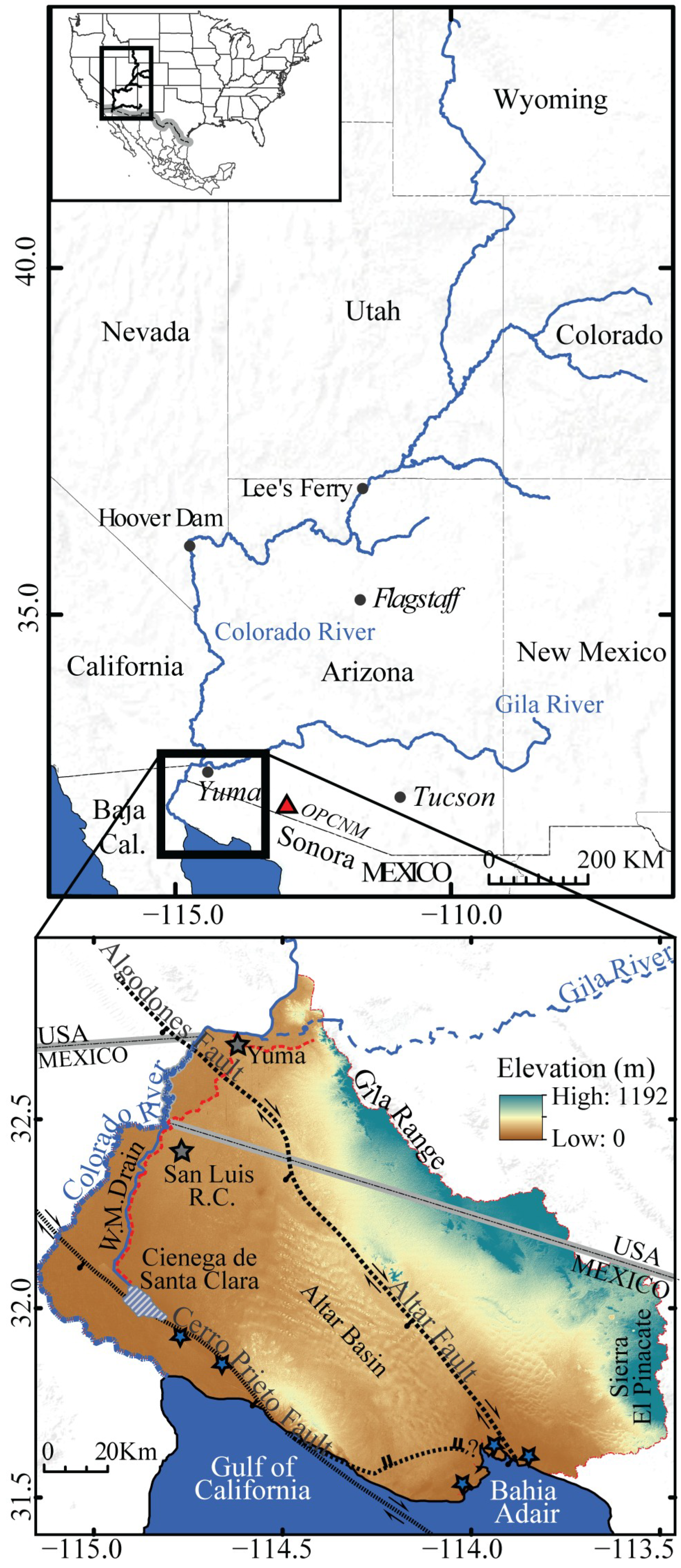
Abstract
:1. Introduction
2. Materials and Methods
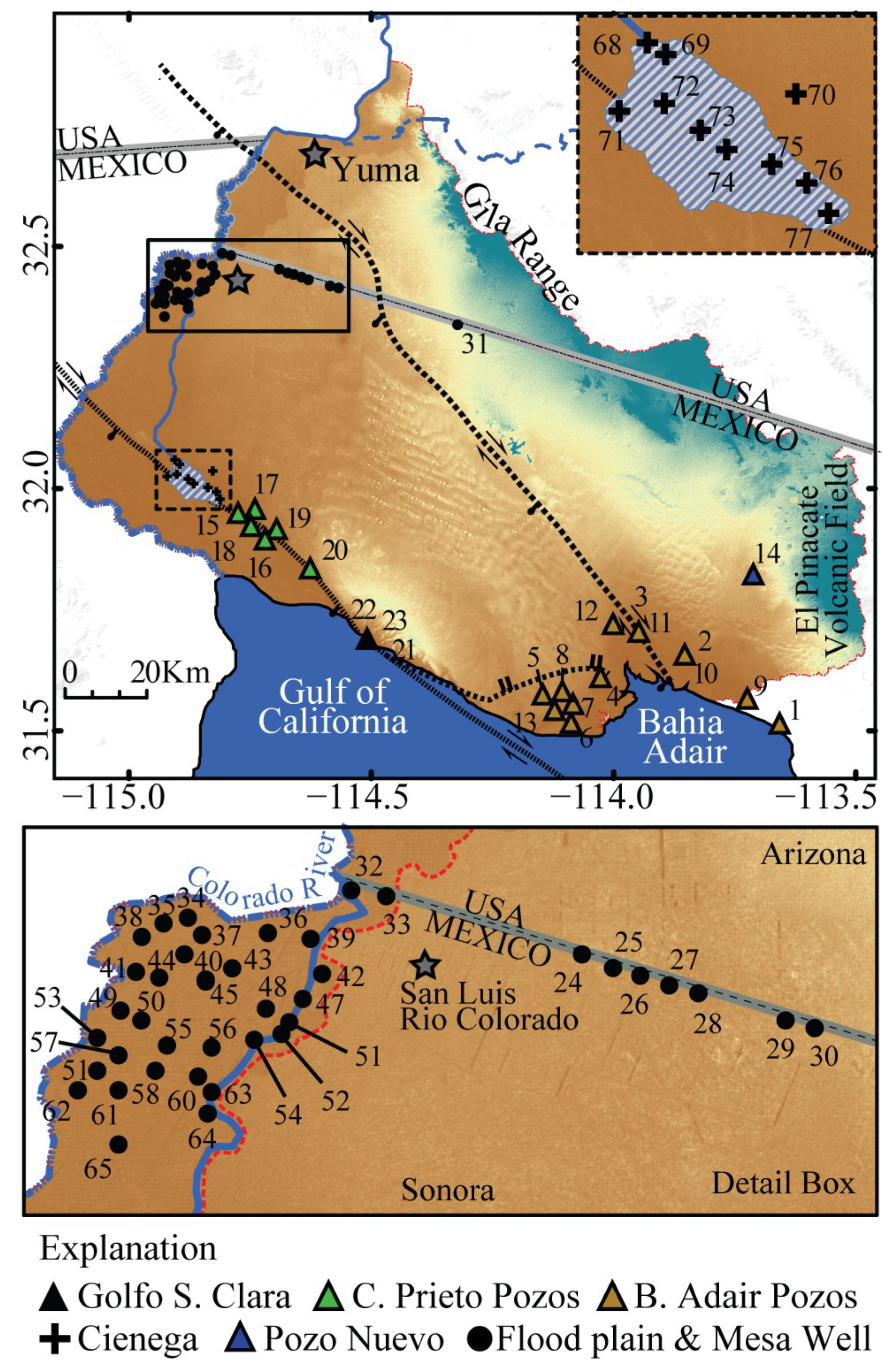
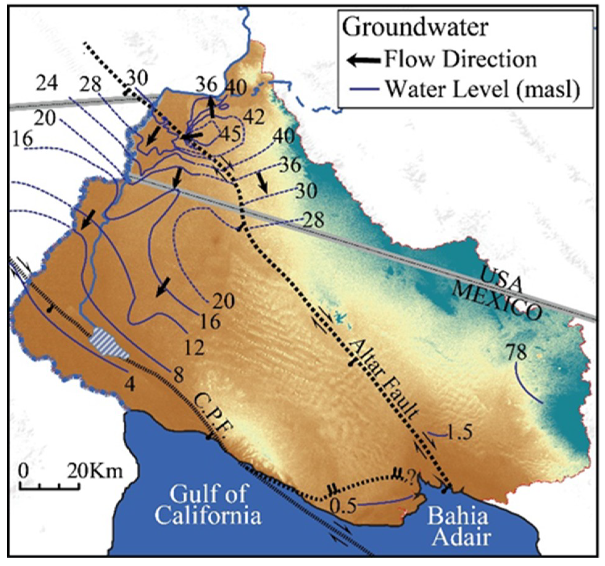
2.1. Study Area
2.2. Data Collection and Analysis
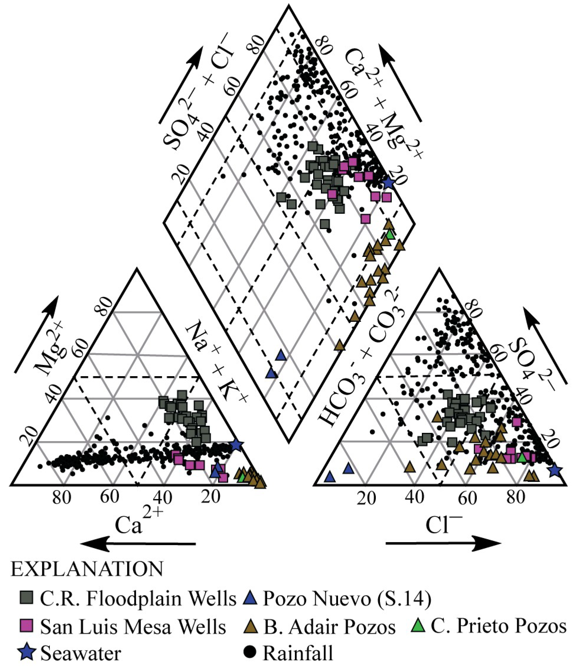
3. Results
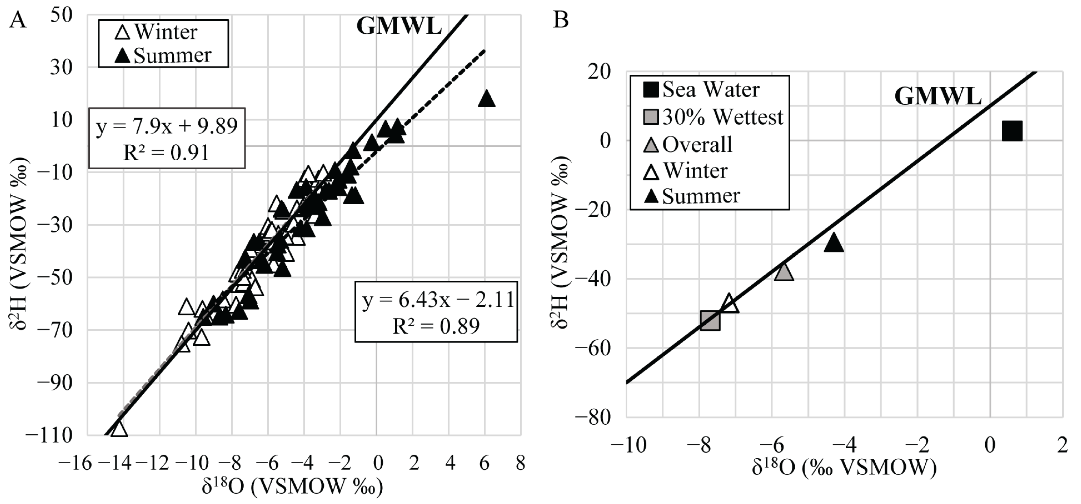
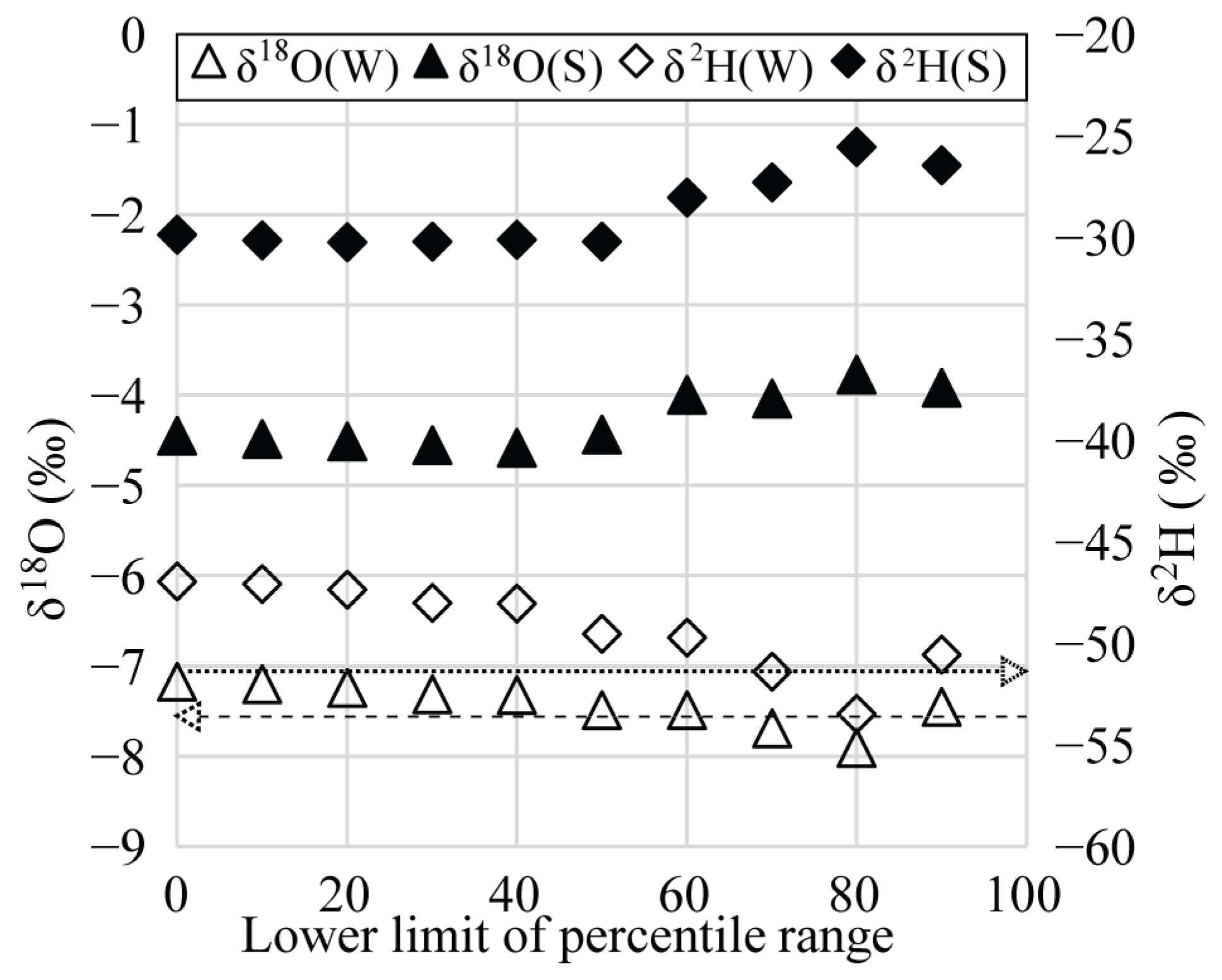
3.1. Rainfall
3.2. Ciénega de Santa Clara
3.3. Colorado River Floodplain and San Luis Mesa
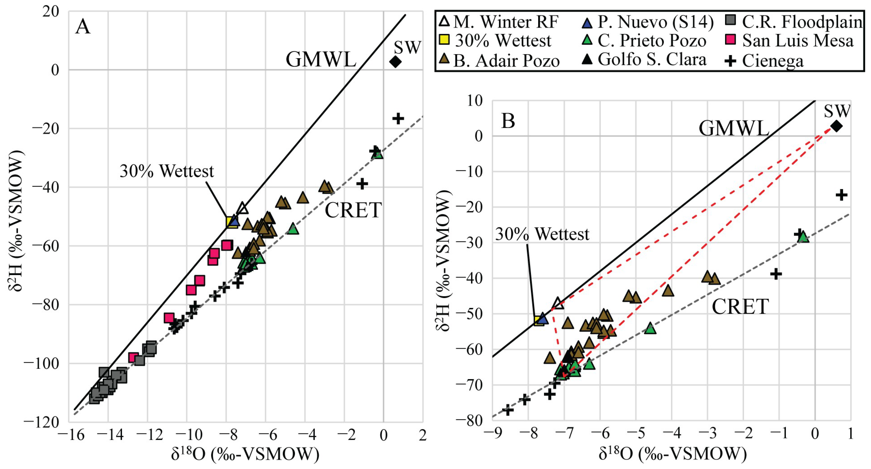
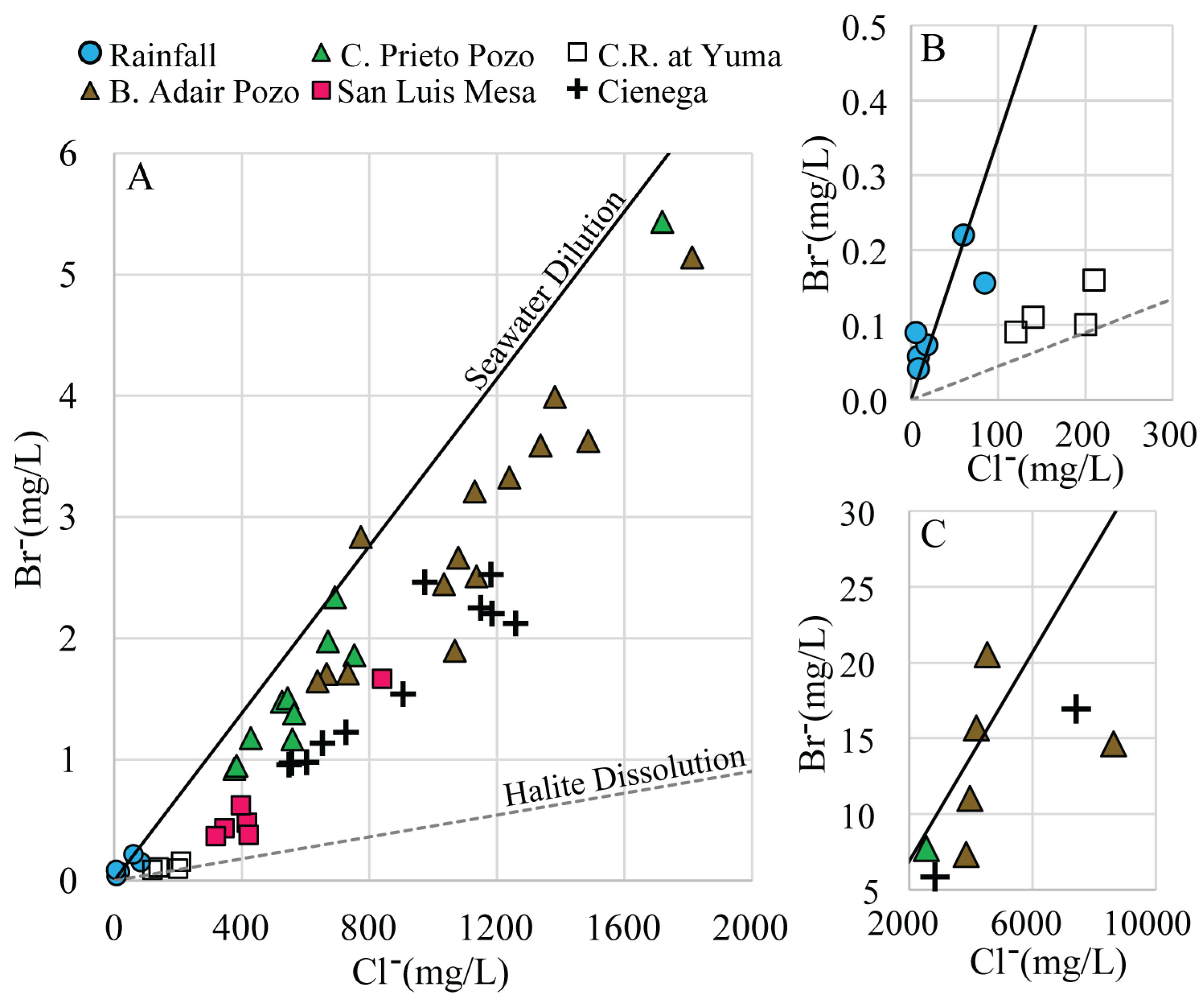
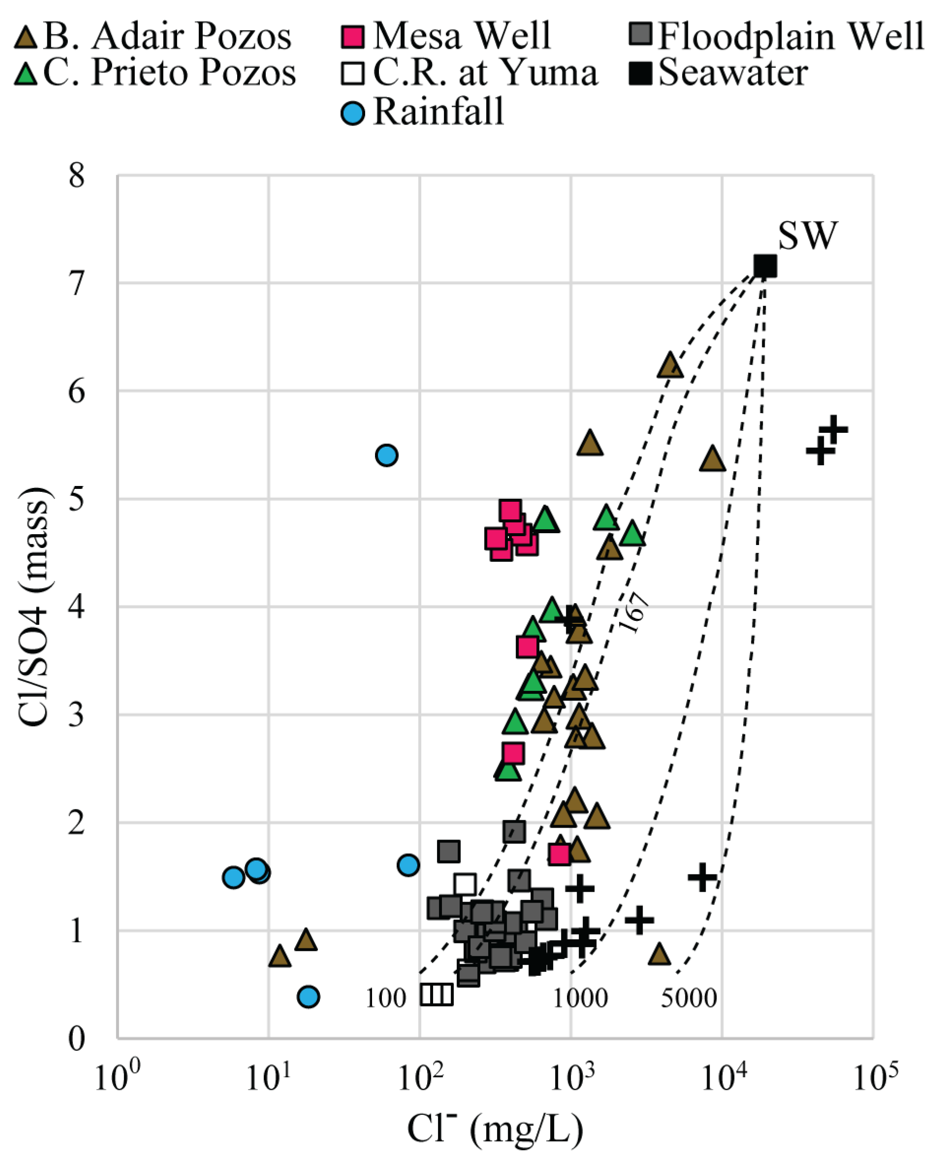
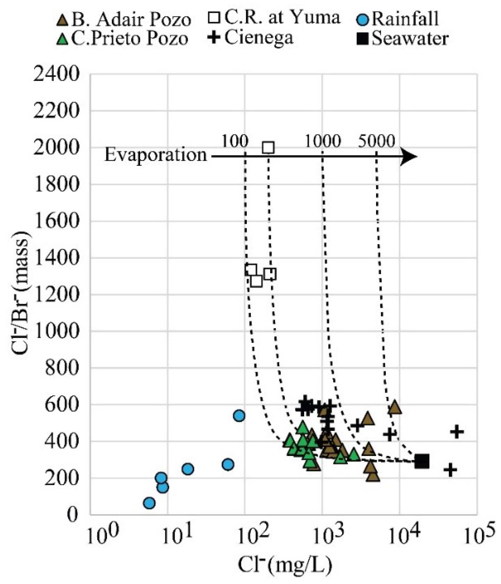
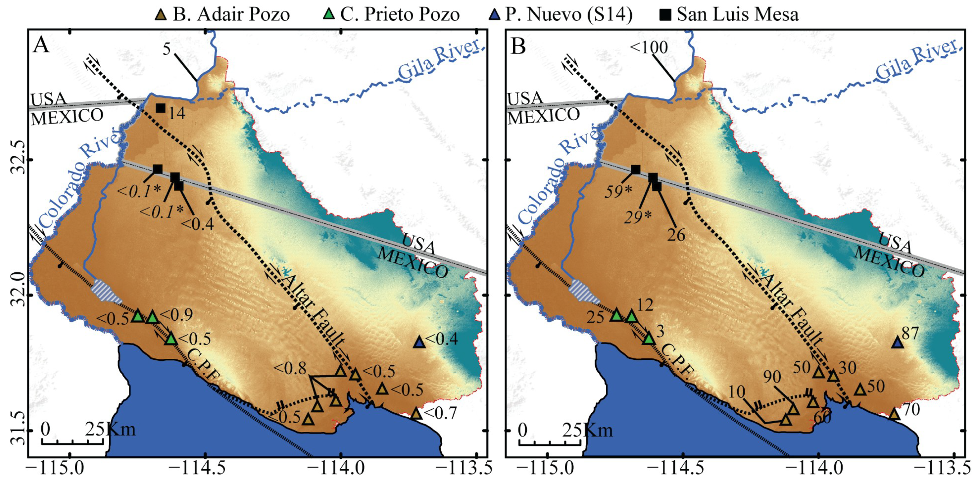
3.4. Gran Desierto Pozos and El Golfo Groundwater
4. Discussion
4.1. Rainfall and Local Recharge
4.2. Origin of the Gran Desierto Pozos
4.3. Conceptual Model
5. Conclusions
Supplementary Materials
Author Contributions
Funding
Acknowledgments
Conflicts of Interest
References
- Sykes, G. The Colorado Delta; Carnegie Institution: Washington, DC, USA, 1937; p. 193. [Google Scholar]
- Leopold, A. The Green Lagoons. In A Sand County Almanac; Oxford University Press: New York, NY, USA, 1949; pp. 150–158. [Google Scholar]
- Ezcurra, E.; Felger, R.; Russell, A.; Equihua, M. Freshwater islands in a desert sand sea: the hydrology, flora, and phytogeography of the Gran Desierto oases of northwestern Mexico. Desert Plants 1988, 9, 35–44. [Google Scholar]
- Glenn, E.P.; Nagler, P.L.; Brusca, R.C.; Hinojosa-Huerta, O. Coastal wetlands of the northern Gulf of California: Inventory and conservation status. Aquat. Conserv. Mar. Freshw. Ecosyst. 2006, 16, 5–28. [Google Scholar] [CrossRef]
- Felger, R. Flora of the Gran Desierto and Rio Colorado of Northwestern Mexico; University of Arizona Press: Tucson, AZ, USA, 2000; p. 673. [Google Scholar]
- Felger, R.; Broyles, B. Dry Borders. In Great Natural Reserves of the Sonoran Desert; University of Utah Press: Salt Lake City, UT, USA, 2006; p. 816. [Google Scholar]
- Glenn, E.P.; Lee, C.; Felger, R.; Zengel, S. Effects of water management on the wetlands of the Colorado River Delta, Mexico. Conserv. Biol. 1996, 10, 1175–1186. [Google Scholar] [CrossRef]
- Lumholtz, K. New Trails in Mexico: An Account of One Year’s Exploration in North-western Sonora, Mexico, and South-western Arizona, 1909–1910; Charles Scribner’s Sons: New York, NY, USA, 1912; p. 411. [Google Scholar]
- Underhill, R.; Bahr, D.; Lopez, B.; Pancho, J.; Lopez, D. Rainhouse and Ocean: Speeches for the Papago Year; University of Arizona Press: Tucson, AZ, USA, 1977; p. 153. [Google Scholar]
- Mitchell, D.R.; Huckleberry, G.; Rowell, K.; Dettman, D.L. Coastal Adaptations During the Archaic Period in the Northern Sea of Cortez, Mexico. J. Isl. Coast. Arch. 2014, 10, 28–51. [Google Scholar] [CrossRef]
- Bowen, T. Julian Hayden and the Adair Bay Shell Site. Kiva 1998, 64, 137–143. [Google Scholar] [CrossRef]
- Hayden, J. The Sierra Pinacate; University of Arizona Press: Tucson, AZ, USA, 1998; p. 96. [Google Scholar]
- Seager, R.; Ting, M.; Held, I.; Kushnir, Y.; Lu, J.; Vecchi, G.; Huang, H.P.; Harnik, N.; Leetmaa, A.; Lau, N.C.; et al. Model Projections of an Imminent Transition to a More Arid Climate in Southwestern North America. Science 2007, 316, 1181–1184. [Google Scholar] [CrossRef]
- Ault, T.; Mankin, J.; Cook, B.S. Relative impacts of mitigation, temperature, and precipitation on 21st-century megadrought risk in the American Southwest. Sci. Adv. 2016, 2, e1600873. [Google Scholar] [CrossRef] [PubMed]
- Lancaster, N.; Greeley, R.; Christensen, P.R. Dunes of the Gran Desierto Sand-Sea, Sonora, Mexico. Earth Surf. Proc. Land. 1987, 12, 277–288. [Google Scholar] [CrossRef]
- Beveridge, C.; Korukek, G.; Ewing, R.C.; Lancaster, N.; Morthekai, P.; Singhvi, A.K.; Mahan, S.A. Development of spatially diverse and complex dune-field patterns: Gran Desierto Dune Field, Sonora, Mexico. Sedimentology 2006, 53, 1391–1409. [Google Scholar] [CrossRef]
- Conner, C.; National Park Service, Tucson, Arizona, USA. Personal communication, 2017.
- Pacheco, M.; Martín-Barajas, A.; Elders, W.; Espinosa-Cardeña, J.M.; Helenes, J.; Segura, A. Stratigraphy and structure of the Altar basin of NW Sonora: Implications for the history of the Colorado River delta and the Salton trough. Rev. Mex. Cienc. Geol. 2006, 23, 1–22. [Google Scholar] [CrossRef]
- Merriam, R. San Jacinto fault in the northwestern Sonora, Mexico. Bull. Geol. Soc. Am. 1965, 76, 1051–1054. [Google Scholar] [CrossRef]
- Curray, J.R.; Moore, D.G. Geologic history of the mouth of the Gulf of California. In Tectonics and Sedimentation Along the California Margin; Crouch, J.K., Bachman, S.B., Eds.; Society of Economic Paleontologists and Mineralogists: Los Angeles, CA, USA, 1984; Volume 38, pp. 17–36. [Google Scholar]
- Gastil, R.G.; Phillips, R.P.; Allison, E.C. Reconnaissance geology of the state of Baja California. G.S.A. Memoire 1975, 140, 1–170. [Google Scholar] [CrossRef]
- Olmsted, F.; Loeltz, O.; Irelan, B. Geohydrology of the Yuma Area, Arizona and California, Water Resources of Lower Colorado River-Salton Sea Area. U.S.G.S. Prof. Pap. 1973, 486–H, 1–273. [Google Scholar]
- May, R.H. Resource Reconnaissance of the Gran Desierto. Master’s Thesis, University of Arizona, Tucson, AZ, USA, May 1973. [Google Scholar]
- Dickinson, J.; Land, M.; Faunt, C.; Leake, S.; Richard, E.; Fleming, J.B.; Pool, D.R. Hydrologic Framework Refinement, Ground-Water Flow and Storage, Water-Chemistry Analyses and Water-Budget Components of the Yuma Area, Southwestern Arizona, and Southeastern California. U.S.G.S Sci. Inv. Rep. 2006, 5135, 1–88. [Google Scholar]
- A.D.E.Q. Arizona Department of Water Resources: Well Registry. Available online: https://gisweb.azwater.gov/waterresourcedata/wellregistry (accessed on 15 January 2015).
- CONAGUA. Comisión Nacional del Agua: Actualización de la disponibilidad media anual de agua en el acuífero Valle de San Luis Río Colorado (2601), Estado de Sonora. Available online: https://www.gob.mx/cms/uploads/attachment/file/104293/DR_2601.pdf (accessed on 18 January 2013).
- Coplen, T.B. Reporting of stable carbon, hydrogen and oxygen abundances. Ref. Intercomp. Mater. Stable Isot. Light Elem. 1995, 825, 31–34. [Google Scholar] [CrossRef]
- Gieskes, J.; Rogers, W. Alkalinity determinations in interstitial waters of marine sediments. J. sediment. Res. 1973, 43, 272–277. [Google Scholar] [CrossRef]
- Parkhurst, D.; Appelo, C. User’s guide to PHREEQC (version 2) – A computer program for speciation, batch-reaction, one-dimensional transport, and inverse geochemical calculations. U.S.G.S Water Resour. Inv. Rep. 1999, 99, 1–312. [Google Scholar]
- U.S.G.S. Water-Quality Data for the Nation. Available online: https://water.usgs.gov/owq/data.html (accessed on 12 December 2016).
- Palomares-Ramírez, R.B. Identificación de los componentes hidrogeoquimicos que contaminan el acuífero del Modulo de Riego I del Valle de San Luis, R.C. Master’s Thesis, Universidad Autónoma de Baja California, Mexicali, México, December 2011. [Google Scholar]
- Dettman, D.L.; Flessa, K.W.; Roopnarine, P.D.; Schöne, B.R.; Goodwin, D.H. The use of oxygen isotope variation in shells of estuarine mollusks as a quantitative record of seasonal and annual Colorado River discharge. Geochim. Cosmochim. Acta 2004, 68, 1253–1263. [Google Scholar] [CrossRef]
- Welker, J. ENSO effects on the isotropic (δ18O, δ2H and d-excess) of precipitation across the US using a high-density, long-term network (USNIP). Rapid Comm. Mass Spec. 2012, 17, 1655–1660. [Google Scholar] [CrossRef]
- National Atmospheric Deposition Program (NADP). Available online: http://nadp.slh.wisc.edu/ (accessed on 5 August 2016).
- Craig, H. Isotopic variations in meteoric waters. Science 1961, 133, 213–224. [Google Scholar] [CrossRef]
- Eastoe, C.; Towne, D. Regional zonation of groundwater recharge mechanisms in alluvial basins of Arizona: Interpretation of isotope mapping. J. Geochem. Explor. 2018, 194, 134–145. [Google Scholar] [CrossRef]
- Robertson, F.N. Geochemistry of groundwater in alluvial basins of Arizona and adjacent parts of Nevada, New Mexico, and California. U.S.G.S. Prof. Pap. 1991, 1406–C, 1–91. [Google Scholar]
- Guay, B.; Eastoe, C.; Basset, R.; Long, A. Identifying sources of groundwater in the lower Colorado River valley, USA with δ18O, δ2H, and 3H: Implications for river water accounting. Hydrogeol. J. 2006, 14, 146–158. [Google Scholar] [CrossRef]
- Herczeg, A.L.; Edmunds, W.M. Inorganic Ions as Tracers. In Environmental Tracers in Subsurface Hydrology; Cook, P.G., Herczeg, A.L., Eds.; Springer: Boston, MA, USA, 2000; pp. 31–77. [Google Scholar]
- Towne, D. Ambient groundwater of the Lower Gila Basin: A 2013–2016 baseline study. A.D.E.Q. Rep. 2017, 17-01, 1–74. [Google Scholar]
- Towne, D. Ambient groundwater of the Western Mexican Drainage: A 2016–2017 baseline study. A.D.E.Q. Rep. 2018, 17-02, 1–52. [Google Scholar]
- Jasechko, S.; Taylor, R. Intensive rainfall recharges tropical groundwaters. Environ. Res. Lett. 2015, 10, 124015. [Google Scholar] [CrossRef]
- Zamora, H.A. Environmental Isotope Geochemistry in Groundwaters of Southwestern Arizona, USA, and Northwestern Sonora, Mexico: Implications of Groundwater Recharge, Flow, and Residence Time in Transboundary Aquifers. Ph.D. Thesis, University of Arizona, Tucson, AZ, USA, November 2018. [Google Scholar]
- Clark, I.; Fritz, P. Environmental Isotopes in Hydrogeology; Lewis Publishers: Boca Raton, FL, USA, 1997; pp. 87–88. [Google Scholar]
- Braitsch, O. Salt Deposits, their Origin and Composition; Springer: New York, NY, USA, 1971; pp. 1–26. [Google Scholar]
- Davis, S.N.; Whittemore, D.G.; Fabryka-Marin, J. Uses of chloride/bromide ratios in studies of potable water. Ground Water 1998, 36, 338–350. [Google Scholar] [CrossRef]
- Gribble, G. The diversity of naturally occurring organobromine compounds. Chem. Soc. Rev. 1999, 28, 335–346. [Google Scholar] [CrossRef]
- Bense, V.F.; Gleeson, T.; Loveless, S.E.; Bour, O.; Scibek, J. Fault zone hydrogeology. Earth Sci. Rev. 2013, 127, 171–192. [Google Scholar] [CrossRef]
- Payne, B.; Quijano, L.; Latorre, C. Environmental isotopes in a study of the origin of salinity of groundwater in the Mexicali Valley. J. Hydrol. 1979, 41, 201–2015. [Google Scholar] [CrossRef]
- Fontes, J.C.; Garnier, J.M. Determination of the initial 14C activity of total dissolved carbon: A review of existing models and a new approach. Water Resour. Res. 1979, 15, 325–329. [Google Scholar] [CrossRef]
- Goodfriend, G.; Flessa, K. Radiocarbon Reservoir Ages in the Gulf of California: Roles of Upwelling and Flow from the Colorado River. Radiocarbon 1997, 2, 139–148. [Google Scholar] [CrossRef]


© 2019 by the authors. Licensee MDPI, Basel, Switzerland. This article is an open access article distributed under the terms and conditions of the Creative Commons Attribution (CC BY) license (http://creativecommons.org/licenses/by/4.0/).
Share and Cite
Zamora, H.A.; Wilder, B.T.; Eastoe, C.J.; McIntosh, J.C.; Welker, J.; Flessa, K.W. Evaluation of Groundwater Sources, Flow Paths, and Residence Time of the Gran Desierto Pozos, Sonora, Mexico. Geosciences 2019, 9, 378. https://doi.org/10.3390/geosciences9090378
Zamora HA, Wilder BT, Eastoe CJ, McIntosh JC, Welker J, Flessa KW. Evaluation of Groundwater Sources, Flow Paths, and Residence Time of the Gran Desierto Pozos, Sonora, Mexico. Geosciences. 2019; 9(9):378. https://doi.org/10.3390/geosciences9090378
Chicago/Turabian StyleZamora, Hector A., Benjamin T. Wilder, Christopher J. Eastoe, Jennifer C. McIntosh, Jeffrey Welker, and Karl W. Flessa. 2019. "Evaluation of Groundwater Sources, Flow Paths, and Residence Time of the Gran Desierto Pozos, Sonora, Mexico" Geosciences 9, no. 9: 378. https://doi.org/10.3390/geosciences9090378
APA StyleZamora, H. A., Wilder, B. T., Eastoe, C. J., McIntosh, J. C., Welker, J., & Flessa, K. W. (2019). Evaluation of Groundwater Sources, Flow Paths, and Residence Time of the Gran Desierto Pozos, Sonora, Mexico. Geosciences, 9(9), 378. https://doi.org/10.3390/geosciences9090378