Article

Optimizing an Inner-Continental Shelf Geologic Framework Investigation through Data Repurposing and Machine Learning

by
Elizabeth A. Pendleton
1,*,
Edward M. Sweeney
2 and
Laura L. Brothers
1
1
Woods Hole Coastal and Marine Science Center, U.S. Geological Survey, Woods Hole, MA 02543, USA
2
Santa Barbara Museum of Natural History Sea Center, Santa Barbara, CA 93101, USA
*
Author to whom correspondence should be addressed.
Geosciences 2019, 9(5), 231; https://doi.org/10.3390/geosciences9050231
Submission received: 30 March 2019 / Revised: 14 May 2019 / Accepted: 15 May 2019 / Published: 21 May 2019
(This article belongs to the Special Issue Geological Seafloor Mapping)

Abstract

:
The U.S. Geological Survey (USGS) and the National Oceanic Atmospheric Administration (NOAA) have collected approximately 5400 km2 of geophysical and hydrographic data on the Atlantic continental shelf between Delaware and Virginia over the past decade and a half. Although originally acquired for different objectives, the comprehensive coverage and variety of data (bathymetry, backscatter, imagery and physical samples) presents an opportunity to merge collections and create high-resolution, broad-scale geologic maps of the seafloor. This compilation of data repurposes hydrographic data, expands the area of geologic investigation, highlights the versatility of mapping data, and creates new geologic products that would not have been independently possible. The data are classified using a variety of machine learning algorithms, including unsupervised and supervised methods. Four unique classes were targeted for classification, and source data include bathymetry, backscatter, slope, curvature, and shaded-relief. A random forest classifier used on all five source data layers was found to be the most accurate method for these data. Geomorphologic and sediment texture maps are derived from the classified acoustic data using over 200 ground truth samples. The geologic data products can be used to identify sediment sources, inform resource management, link seafloor environments to sediment texture, improve our understanding of the seafloor structure and sediment pathways, and demonstrate how ocean mapping resources can be useful beyond their original intent to maximize the footprint and scientific impact of a study.

Graphical Abstract

1. Introduction

The U.S. Geological Survey (USGS) began as a collaborative project with the University of Delaware, the National Park Service, the Mid-Atlantic Coastal Resilience Institute, and the National Oceanographic and Atmospheric Administration (NOAA) in 2014 to define the geologic framework of the Delmarva Peninsula coastal system. This mapping effort builds on recent and ongoing hydrographic, geologic, and ecological studies in the area and represents an opportunity to construct a geospatial framework around existing datasets, and acquire new data to fill knowledge gaps. Characterizations and classifications are a key component of all geologic seafloor studies, and machine learning is a powerful tool for creating classifications through the assimilation and interpretation of large hydrographic and geophysical datasets. Geologic studies of the seafloor support coastal and ocean science and management by providing valuable baseline information to monitor seafloor change, identify benthic habitats and sediment resources, understand sediment transport pathways, and bolster risk assessments and geohazard investigations, such as vulnerability to storms, sea-level rise, shoreline erosion, earthquakes, and tsunamis [1,2].
NOAA carried out 31 hydrographic surveys between 2006 and 2013 at 40-m line spacing using multibeam echosounders and sidescan sonars, over more than 5000 square kilometers of the mid-Atlantic inner-continental shelf adjacent to the Delmarva Peninsula, in water depths of 2.5 to 37.5 m, for the purposes of updating nautical charts (Figure 1 and Figure 2; Table 1) [3,4,5,6,7,8,9,10,11,12,13,14,15,16,17,18,19,20,21,22,23,24,25,26,27,28,29,30,31,32,33]. In 2014 and 2015, the U.S. Geological Survey collected swath bathymetry, sidescan sonar, chirp and multi-channel boomer seismic-reflection profiles, bottom photographs, and sediment samples at 200-m line spacing over some of the same area, for the primary purpose of acquiring seismic data [34,35]. Coincident swath bathymetric and backscatter data provided the opportunity for change-detection comparisons with the hydrographic surveys [36,37], while bottom photographs and samples, collected with a GoPro modified, SEABed Observation and Sampling System (SEABOSS), provided validation [38]. These two regional mapping efforts by the USGS and NOAA provided a wealth of seafloor data and an opportunity to combine datasets and use the hydrographic data beyond its original intent while at the same time increasing the resolution and extent of the USGS framework study. This data collaboration optimizes resources, expands coverage, and is an example of the “map once, use many times” mantra that exemplifies interagency and interdisciplinary cooperation.
Machine learning has been applied to bathymetric and backscatter datasets to classify the seafloor and benthic communities [39,40,41,42,43,44,45] for over two decades. Previous studies have tested the ability and performance of different and increasingly sophisticated machine learning algorithms on these types of data [41,42,44,46]. Supervised, object-based techniques (i.e., random forest) typically produce classifications with better accuracy than unsupervised (e.g., iso cluster) or simpler supervised methods (i.e., maximum likelihood classification (MLC)) [41]. Here we tested the ability of simple and more complex classification methods to discriminate classes of the seafloor using bathymetric and backscatter datasets and derivatives from 33 surveys on the continental shelf offshore of the Delmarva Peninsula. Since the hydrographic data were not acquired with geologic products as an objective and, as such, contained numerous artifacts associated with acquisition that typically pose a challenge to machine learning, the first goal of this study was to determine if the repurposed hydrographic data could be used to conduct an automated seafloor classification, given the artifacts and acquisition differences among surveys. With a modest goal established, unsupervised and supervised methods were tested for feasibility on a subset of the data, then applied to the entire 33-survey dataset following a successful feasibility test. This study utilizes repurposed hydrographic data, applies machine learning algorithms for efficient and objective classification, and produces geologic seafloor data products for a large area of the mid-Atlantic shelf.

2. Geologic Setting

The Delmarva Peninsula is situated along the mid-Atlantic coast between Delaware and the Chesapeake Bay (Figure 1). The Peninsula is a megaspit that formed in the Mio-Pliocene from material delivered by rivers and braided streams [47,48,49]. The continental shelf offshore of the Delmarva Peninsula is just over 100 km wide. Shelf slopes, tidal range, wave height, littoral transport, barrier island morphology, and historical erosion rates differ between the northern half of the Delmarva coast, from Cape Henlopen to the southern tip of Assateague Island (mostly stable over the long-term, except near Ocean City Inlet), and the southern half, from Chincoteague Bight to Fisherman’s Island (mostly erosional) [49,50]. These differences along the coast create two distinct coastal compartments, such that the northern half of the Delmarva Peninsula is considered wave dominated, while the southern section of the Delmarva Peninsula is considered a mixed energy coast [51,52].
The surficial sediments of the inner-continental shelf from Cape Henlopen to the mouth of Chesapeake Bay have been described as arkosic to subarkosic sands [53,54,55,56]. Sand ridges interspersed by zones of flat seafloor characterize much of the northern half of the Delmarva inner-continental shelf [37,57,58] (Figure 1). The sand ridges are mobile and locally bury a transgressive surface [37,53,59,60,61,62], which results in local differences in grain size [53]. Fewer sand ridges are found on the inner shelf off Chincoteague Bight and the Virginia barrier islands (Figure 1). Here the less-undulating seafloor is composed of a discontinuous sheet of medium to fine sand and gravelly sand, with a muddy sand area located within Chincoteague Bight [38,63,64].

3. Methods

3.1. Data Sources

Thirty-three hydrographic and geophysical datasets were collected between 2006 and 2015 on the inner-continental shelf offshore of the Delmarva Peninsula (Table 1; Figure 2). These data can be broken into two groups. The first group of data consists of NOAA hydrographic surveys collected by Leidos (formerly Science Applications International Corporation (SAIC)) between 2006 and 2013 with 40-m line spacing, using a RESON 8101 (240 kHz) or a RESON 7125 (200 or 400 kHz) multibeam echosounder (MBES) and a Klein 3000K sidescan sonar system, for the purposes of updating nautical charts [3,4,5,6,7,8,9,10,11,12,13,14,15,16,17,18,19,20,21,22,23,24,25,26,27,28,29,30,31,32,33]. These data were acquired to IHO S-44 5th edition Order 1a specifications, and as such are accurate within 0.5 m vertically and 2 m horizontally. Small gaps, typically less than five% of the swath width in water depths less than 12 m in the NOAA bathymetric data, were filled using an inverse distance weighed (IDW) interpolant, then the data were resampled to 25 m per pixel (mpp). Backscatter intensity derived from the GSF (generic sensor format) MBES data was processed with the Fledermaus Geocoder Toolbox. Backscatter intensity derived from sidescan sonar data was processed with Chesapeake Technology’s SonarWiz. All backscatter imagery (MBES and sidescan sonar) was filtered to reduce speckling and noise and resampled to 25 mpp. The MBES data contained only beam-average backscatter intensity. Beam-average data can produce high-quality backscatter imagery, however, the full-time series has a more dynamic range in a final backscatter mosaic when compared with beam-average data. For this reason and reasons related to acquisition artifacts, the Klein sidescan sonar data were usually preferred in this study over the beam-averaged MBES backscatter data, especially in areas where the Reson 8101 was used.
The second group of data consists of two USGS geophysical surveys conducted in 2014 and 2015 [34,35]. SwathPlus interferometric (234 kHz) bathymetric data were processed with BathySwath and Caris. Bathymetric data were interpolated (with IDW) to fill gaps, typically less than 30% of the swath width, then resampled to 25 mpp. The higher resolution NOAA MBES data were given priority over the more widely spaced interferometric bathymetric data when creating the merged bathymetry grid, which has an assumed accuracy of 1 m vertically and 4 m horizontally. Sidescan sonar data were acquired in 2014 with a Klein 3000 and in 2015 with an Edgetech 4200. Sidescan sonar data were processed using SonarWiz. Filtered backscatter mosaics were resampled to 25 mpp.
A suite of 227 sediment samples were collected during the USGS surveys and were analyzed for grain-size statistics and carbonate content by the USGS Woods Hole sediment analysis lab following methods outlined by McMullen et al. [65]. This study uses the Barnhardt classification [66] (Figure 3) to characterize sediment texture, which is based on four end-member sediment units [67]: rock (R; grain size greater than 64 mm (mm) or less than −6 phi), gravel (G; grain size 2 to 64 mm or −1 to −6 phi), sand (S; grain size 0.062 to 2 mm or 4 to −1 phi), and mud (M; grain size less than 0.062 mm or greater than 4 phi). The classification is further divided into 12 composite units, which are two-part combinations of the four end-member units. This classification is defined such that the primary texture, representing more than 50% of an area’s texture, is given an uppercase letter, and the secondary texture, representing less than 50% of an area’s texture, is given a lowercase letter. If one of the basic sediment units represents more than 90% of the texture, only its uppercase letter is used (Figure 3).

3.2. Image Analysis Approach and Testing

The primary objectives of the initial analysis were: (1) determine if these data were of sufficient quality to conduct a seafloor classification, and (2) identify a simple representation of seafloor variability based on bathymetric and backscatter data. To achieve these goals, a relatively high quality single dataset was chosen from among the 33 surveys to use as a subset for sensitivity and accuracy testing. Four distinct classes were identified using backscatter and seafloor slope. Sediment samples provided the ground truth and texture characterization for the classes (Figure 4). Unsupervised (iso cluster) and simple supervised (maximum likelihood) classifications were conducted on the test area to see if machine learning algorithms could capture the user identified classes from backscatter and slope. The accuracy of each test classification was assessed using total accuracy and Cohen’s kappa coefficient (see Section 3.3). Based on initial tests, classification was then expanded to the entire dataset.
The relative hardness or softness of the seafloor, which is closely related to sediment texture and cohesion, is distinguished using changes in backscatter intensity as an indicator of differences in particle size and composition [68]. Differences in the geomorphologic structure of the seafloor is readily identified using seafloor slope, calculated using a three by three cell window in ArcGIS 10.5.1. Sand ridges have relatively steep slopes (here, greater than ~1.75 degrees) and flat areas of seafloor have low slopes. The four target classes, based on observations of the acoustic data and grain-size statistics from sediment samples were: (1) high backscatter areas with low seafloor slopes (HBLS), which are primarily composed of sand with shell and gravel; (2) high backscatter areas with steep slopes (HBSS) associated with the stoss side of sand ridges, also composed of sand with shell and gravel; (3) low backscatter areas with low slopes (LBLS), composed primarily of sand with some mud; and (4) low backscatter areas with steep slopes (LBSS), comprising the tops and lee sides of sand ridges and composed of nearly 100% sand (Figure 4; Table 2).
Two classifications were evaluated on the test dataset using the image classification toolbox in Esri’s ArcGIS. The iso cluster (ISO) classification was chosen as the simplest and first method. In ISO analysis, the user needs no prior knowledge of the seafloor or the input data, and the number of classes is often unknown. As it is applied in ArcGIS, the ISO algorithm uses a modified iterative optimization clustering procedure known as migrating means to separate cells into a user-specified number of classes. For our purposes, we wanted to see if ISO could identify our target classes based on statistical relationships between slope and backscatter for each pixel, without supplying any user knowledge except for the number of classes. ISO distinguished three of the four target classes in backscatter and slope data: high backscatter intensity, low backscatter intensity, and steep slopes, but could not further discriminate a meaningful fourth class for sloping areas with high backscatter. For example, sand ridges often have areas of high backscatter associated with their stoss side, while the lee side is consistently low backscatter.
The second method evaluated was a supervised maximum likelihood classification. In MLC, representative pixels are identified for each class by a user with prior knowledge of the classes to be identified. This step creates a training dataset that is then used to determine the class of all other pixels based on the variance and covariance of the class signatures. The training dataset contained 20 polygons drawn around representative pixels for each class, ranging in size from 20 to greater than 1000 pixels. Pixels in the classified raster are assigned to the class that they have the highest probability of being a member. The target classes were the same as described above: LBLS, HBLS, LBSS, and HBSS.

3.3. Accuracy Evaluation

Following initial image analysis on the test dataset using unsupervised ISO, and supervised MLC, two hundred randomly-located, reference points (RPs) were created within the test dataset area. The RPs were user-assigned to one of the four classes defined for seafloor types (LBLS, HBLS, LBSS, and HBSS). User-defined RPs were compared to the classified pixels for each test method, again using ArcGIS. A confusion matrix was created from the RPs and the classified points were used to test the validity of the classification method in the test area. Total accuracy, or the percentage of correctly classified pixels, was calculated, as well as the Cohen’s kappa coefficient, which indicates the agreement between classified pixels and RPs and adjusts for inflated accuracy due to chance.

3.4. Applying Classification to the Entire Dataset

Based on initial feasibility and accuracy findings (see the results section for test area accuracies or Table 3), it was determined that these data could support machine learning classification, using only two inputs, backscatter and slope. In initial testing, we found that the iso cluster performed well at distinguishing high and low backscatter, but was inadequate at differentiating slope differences associated with high and low backscatter. With that knowledge, moving forward with classification of the entire study area, and in order to address relative backscatter value differences introduced by combining survey data with different instrumentation and acquisition parameters, we utilized the ISO’s ability to quickly, consistently, and objectively differentiate high and low backscatter, prior to supervised classification. To achieve this, an 8-bit backscatter image of each of the 33 survey areas was passed through ISO analysis to produce a two-class outcome: high and low backscatter. This additional step to pre-classify backscatter reduced uncertainty associated with user-defined high and low backscatter decisions, minimized the effects of artifacts on the classification, and normalized the backscatter range values among surveys and instruments.
Following ISO classification of the backscatter data for all surveys, pre-classified backscatter for all 33 surveys was combined with slope, and an MLC was done using two inputs. Additional data layers were introduced, including curvature (the second derivative of bathymetry, which determines if a surface is concave or convex), shaded-relief (which helps captures the slipface and apex of sand ridges with a common orientation), and bathymetry. These secondary inputs would help determine if introducing more data complexity, dimensionality, redundancy, and relationships improved classification results. Another MLC was conducted on the five data inputs (ISO classified backscatter (high and low), slope, bathymetry in meters below the North American Datum of 1988, shaded-relief, and curvature), using 112 polygons as the training dataset. Finally, a random forest (RF) classification in ArcPro was conducted for all 33 surveys and five inputs. RF classification is a supervised method that is an ensemble classification based on several individual decision trees. Decision trees have been shown to achieve good results for MBES-type data classifications [41]. In ArcGIS forest-based classifications are an adaptation of Breiman’s random forest algorithm, in which decision trees are created using the training data, then trees generate predictions, and the final outcome is decided based on a voting scheme. The same training data set from MLC, consisting of 112 polygons, was used for RF with the same four target classes of LBLS, HBLS, LBSS, and HBSS.
The workflow from data source to classification output is summarized in Figure 5. All analysis, including merging, interpolating, filtering, and resampling the data in preparation for machine learning classification was conducted in ArcGIS. Following image analysis of the entire dataset using the three different methodologies, another 200 randomly-located, reference points (RPs) were created within the classified area. Once again, confusion matrices were created from the RPs and the classified points were used to test the validity of the classified seafloor.

4. Results

4.1. Mapped Accuracy

The best accuracy results in the test area were achieved with the supervised maximum likelihood classification (Table 3). The ISO classification performed with the lowest total accuracy due to its inability to distinguish all four target classes (Table 3), however ISO performed at 100% when distinguishing between high and low backscatter areas.
Accuracy and kappa values were lower for classifications evaluated over the whole study area (all 33 surveys) than on the test area (Table 3). The MLC performed on two inputs (MLC 2 inputs) had the lowest accuracy and kappa coefficient, while the MLC performed on five input data layers (MLC 5 inputs) achieved slightly better results, and the random forest (RF 5 inputs) achieved the best results for the entire study area.

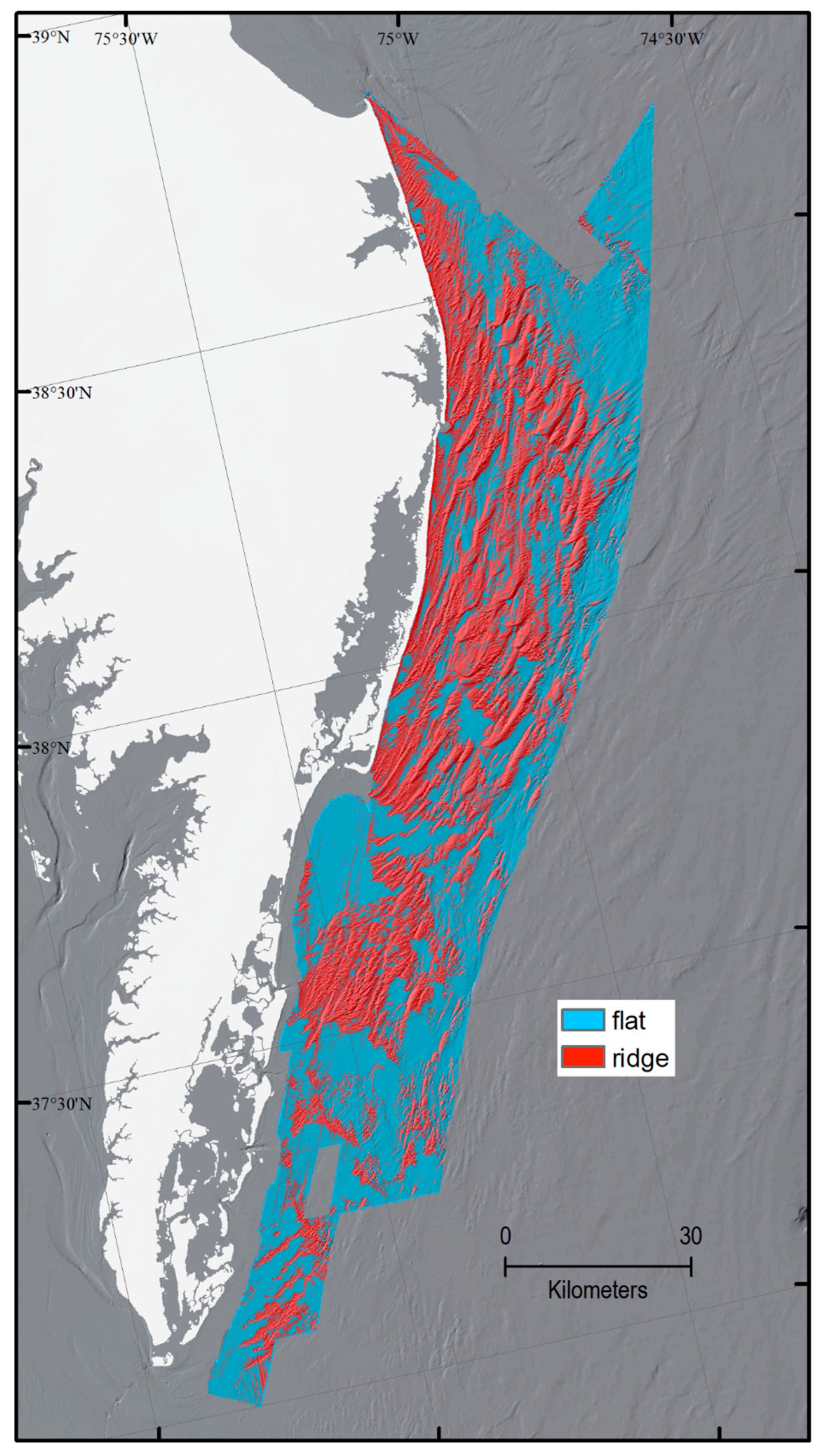
4.2. Classified Maps

The classified maps for the test area are displayed in Figure 6A,B. The ISO analysis only distinguished three of the four classes (Figure 6A). MLC captures the four target classes, but contains more striping introduced by artifacts in the backscatter data layer (Figure 6B).
The classified maps over the entire study for the 33 individual hydrographic and geophysical surveys are shown in Figure 7A–C. At a glance, results appear fairly similar, however, the best accuracy and kappa coefficient were achieved for the whole study area using random forest with five input data grids (Table 3). The initial ISO analysis of backscatter prior to the supervised classifications over the whole study area was advantageous in that it reduced stripiness by normalizing relative backscatter values among surveys and instruments. The classified area was 5394 km2. LBLS and LBSS classes comprise the largest percentages of the classified seafloor by area at 39% and 38%, respectively. High backscatter areas make up 23% of the seafloor by area with HBLS accounting for 15%, and HBSS accounting for 8%.
We generated the geomorphic structure and sediment-texture maps by integrating the results of the random forest analysis with seafloor sample data. Sand ridges are a prominent geomorphic feature in the study area (Figure 1) that are defined primarily by relief. A meaningful geomorphologic structure map can be derived from the four classes by ignoring the backscatter differences and focusing on the steeper slope classes. Figure 8 shows the areas of the seafloor that are classified as HBSS or LBSS, and thus can be considered ridges. Approximately 46% of the classified seafloor can be considered sand ridge, while the remaining 54% is relatively flat.
Grain-size statistics of sediment samples were averaged by class (Table 2). LBLS and LBSS classes have high sand content (>90%) and low carbonate concentrations, whereas sediments in the high backscatter classes (HBSS and HBLS) have a higher gravel-sized component (~18%) and higher shell content (18–28%; Table 2 and Figure 4), but are still primarily sand. Grain size data also indicate slightly higher mud content within the low slope classes (3% to 7%, versus 1% to 2% in steeper sloping areas). Applying the Barnhardt classification to the mean grain-size statistics for each class produces two unique sediment texture categories within the classified area: sand (S) and sand with gravel (Sg). Both low-backscatter classes (LBLS and LBSS) have mean sand contents over 90%, so they are classified as sand. The two high-backscatter classes (HBLS and HBSS) have sand contents between 75% and 84% and gravel contents between 14% and 25%, which makes them Sg (or sand with gravel; Figure 9). The S class represents roughly 77% of the seafloor by area, suggesting that three-quarters of the mapped seafloor may be greater than 90% sand. The Sg class represents 23% of the seafloor, suggesting that the seafloor is still primarily sand in these areas, but also contains more than 10% gravel and/or more abundant shells.
Displaying individual samples over the sediment texture map (Figure 10) shows where mean grain-size statistics in each class differ from the sediment texture classification assigned based on RF classification. Four mud-rich samples (greater than 50% mud) were collected from areas that were not acoustically different from adjacent areas of sandier sediment texture. Nine samples considered gravel-rich (greater than 50% gravel) or shell-rich (greater than 50% shell) were also collected, and fell mostly within the HBLS or HBSS classes. For areas classified as S in the sediment texture map, 86% of the samples were at least 90% sand, and therefore in agreement with the S classification. The 14% that differed were samples classified as Sm (7%), Sg (5%), or the previously mentioned mud-rich samples (<2%). For areas classified as Sg in the sediment texture map, 55% of the samples were also Sg, while 36% were S, 7% were shell or gravel-rich (Gs), and 2% was Sm. Sampling positional accuracy is assumed to be +/–50 m, and could be erroneously classified if sampled near a class boundary.

5. Discussion

Hydrographic and geophysical datasets collected with different instrumentation over a 10-year period pose challenges for seafloor classification. Ideally, the hydrographic data would have been time-series MBES data and would have lacked artifacts and range differences that came with combining sidescan sonar and beam-averaged MBES backscatter across surveys. Due to these challenges in the backscatter data, we adopted ISO classification to standardize and normalize the high and low backscatter values among surveys. Previous studies informed our selection of methods [41,43,63,64,65] and initial tests helped address challenges associated with the backscatter data repurposing and conglomeration. ISO has been shown as a useful first step when evaluating the spatial variability of seafloor facies [43,69], but typically requires samples or subsequent reclassification to achieve desired results. Here we found that ISO lacked the ability to distinguish all four classes of interest; however, it performed with perfect accuracy on the test area dataset when distinguishing only between high and low backscatter. This particular strength of ISO analysis, and the fact that it is very simple to execute and requires no prior user knowledge of the data, made it a simple and valuable first step in preparing the entire 33-survey data collection for supervised classification. By performing a simple ISO analysis on individual surveys, we were able to normalize relative changes in backscatter among surveys with different instruments and acquisition parameters, and thus overcome some of the challenges associated with repurposing these types of data for automated classification. This initial ISO step also minimized striping and minor artifacts within some surveys (Figure 4), and consistently distinguished high and low backscatter in agreement with a user’s discrimination. The two surveys with the most abundant artifacts that interfered with high and low backscatter determination were H12160 and H12161. A reasonably accurate, general sediment texture map of the study area could be generated using only ISO, which would capture the differences in high and low backscatter and corresponds to the difference in S and Sg within this study area.
Because the first goal of this study was to determine the feasibility of conducting a machine learning classification using repurposed data, we adhered to relatively simple initial testing and methods, from the classification techniques used (ISO and MLC), to data sources (only two initial inputs), and the four target classes. Results revealed that these data were usable for auto-classification, as long as the expectations of classified outcomes were not too complex. Two data layers could provide enough seafloor variability to define four classes, but accuracy was improved by adding additional data inputs and increasing the complexity of the classification algorithm, which is consistent with findings from previous studies using MBES datasets [41,70,71].
Sediment samples with grain-size statistics used for validation were averaged within each class. Averaging sediment statistics has the effect of removing anomalous samples or patches of seafloor that may exist within or in addition to the defined four classes. Some anomalous samples or seafloor areas could not be distinguished in the geophysical and hydrographic data as it is processed and analyzed in this study. For example, samples that are far muddier than the average sediments within the LBLS class exist, but they are not captured by this classification (Figure 9 and Figure 10), and cannot be resolved at the 25 mpp resolution of the source data.
Sub-circular and linear seafloor features, such as those observed in Figure 10 are shown at 2 mpp. Such features are often depressions associated with outcropping units of finer grained material here [38,55] and in other study areas [72]. These relatively small features (typically less than 100 m) are not representative of the surrounding seafloor and not identifiable at the 25 mpp scale. The scale at which this study is conducted cannot resolve the linear and sub-circular features identified in the backscatter at higher resolution (2 mpp). The sediment samples associated with these features are not representative of the larger LBLS class, and averaging out their impact on a class is therefore acceptable for this regional-scale classification.
Other samples that differ from the average sediment statistics for each class are shown in Figure 9. Most mud-rich samples are explained by their occurrence in small-scale sub-circular and linear features, except for the mud-rich samples in Chincoteague Bight. These muddier than average samples reflect the sediment texture across a fairly large area of muddy sand that is associated with dewatered backbarrier muds or an ebb plume of suspended sediment [51]. However, this change in seafloor texture is not recognizable in the acoustic data [38] and, therefore, would not be identifiable by a classification relying on acoustic data. Gravel and shell-rich samples exist in a few locations throughout the survey and are often associated with bioherms as indicated in the bottom photographs [34,35], or occasional coarser-grained (than average HBLS) flat areas of high backscatter.
It would be misleading to provide these generalized and regional-scale textural and geomorphologic classifications without outlining the limitations and assumptions that resulted in the classification outcomes presented here. A good way to illustrate application scale and areas where generalized geologic maps may not capture all the seafloor variability for evaluation by managers and other data users is to display the sediment sample locations along with the classification, thereby identifying the areas where differences in classified texture and actual sediment texture may exist, and where further discrimination or more detailed analysis may be required. Previous regional geologic studies of the Delmarva inner-continental shelf have defined the seafloor as relatively homogenous, consisting of primarily sand [52,55], and this study conducted using simple classes with mean grain-size statistics would seem to confirm this description, such that the majority of textural variability along this inner-continental shelf can be explained by relatively small changes in sand concentration, identified using only two sediment texture classes (Figure 9). However, a more heterogeneous sediment environment, especially one in a periglacial environment, where all sediment types are possible and often adjacent, would require more complex substrate classes and input data types, such as the secondary features defined by [41].
Pendleton et al. [38], created sediment texture and geomorphology maps of the area covered by USGS surveys with user-defined polygons [34,35,38]. The sediment texture classification used the same sediment samples as the current study and was classified according to the Barnhardt classification (Figure 11). In general, the sediment texture and geomorphology maps produced here are in good agreement with the manual classification study (Figure 11). Manual classification offers the flexibility of identifying features at multiple resolutions, so capturing the muddy pits and linear features that are not visible at 25 mpp is possible, but user digitization is time consuming and not as objective as machine learning techniques.
Producing regional geologic information maps from repurposed hydrographic data is cost effective for programs, resourceful, efficient, collaborative, inter-disciplinary, and can maximize the scientific impact and footprint of a geologic investigation. The methodology used here required generalization of more complex sediment texture and geomorphology, but the benefits of creating these interpretations outweighs the limitations. A more robust interpretation of seafloor geology would include surficial geologic units derived from shallow sub-bottom interpretations and could be integrated with the sediment texture and geomorphology maps produced here. Those maps and interpretations will be part of the next phase of the regional geologic framework study along the Delmarva Peninsula that aims to link coastal and shelf processes with vulnerability. The recommendations from this study are that any mapping effort, regardless of scope or budget, can benefit from a “map once, use many times” attitude, and repurposing and machine learning classification can create new geologic products quickly and inexpensively that can support science objectives as well as student opportunities.

6. Conclusions

This study evaluated the feasibility of using repurposed hydrographic data to produce classified geologic maps of the seafloor, and confirms that it is possible but requires modest expectations and sensitivity testing. This classification of the sea floor at 25-m resolution over a nearly 5400 km2 area of the Delmarva inner-shelf would not have been possible without the repurposing of hydrographic survey data in conjunction with new geophysical data and samples. The classification produced here can be further divided into sediment texture and geomorphologic maps. The use of automated classification techniques makes interpretation of such a large and diverse dataset feasible. However, there are limitations to these types of interpretations. Acquisition artifacts, especially in the MBES backscatter mosaics, often creates striping in the imagery that can be erroneously interpreted as high backscatter. Filtering, smoothing, and resampling the data prior to classification can help reduce the artifacts, but some large artifacts can persist in the interpretations. The seafloor along the Delmarva inner-continental shelf is more complex than four acoustic classes, two sediment texture classes, and two geomorphologies, but the available data, resolution, and the methodology used here do not support further discrimination. As such, they are meant as a first step to geologic characterization of the continental shelf.
Based on accuracy tests of the classification evaluated here, the random forest classifier produced the best results when compared at reference points. ISO was useful for distinguishing high and low backscatter areas, but was not capable of identifying all four target acoustic classes. ISO can be a useful starting place for these types of studies. Relatively simple and regional-scale classifications can be used to advise finer-scale or more targeted follow-up studies. Additionally, large volumes of hydrographic data that have been collected on the continental shelf for charting purposes can be repurposed to support geologic seafloor investigations without the added expense of new data acquisition. The benefits of classified seafloor datasets are numerous and include providing baseline science for ocean and coastal resource management, facilitating and enabling related research, and raising public awareness and engagement in ocean and coastal science, and management [1].
Finally, this classification contributes to the growing body of research that is providing schemes and methods for the classification of seafloor data sets. An important takeaway from this study is that it is essential to know the limitations of the source data, know whether the discriminations you want to make in the data are possible given data inputs, and choose methods and classes according to what can be supported by the data quality. Patience, testing, and method assimilation can improve outcomes.

Author Contributions

Conceptualization, E.A.P., E.M.S., and L.L.B.; Methodology, E.A.P. and E.M.S.; Validation, E.A.P. and E.M.S.; Formal analysis, E.A.P. and E.M.S.; Investigation, E.A.P. and E.M.S.; Writing—original draft preparation, E.A.P. and E.M.S.; Writing—review and editing, E.A.P. and L.L.B.; Visualization, E.A.P.; Supervision, E.A.P. and L.L.B.; Project administration, L.L.B.; Funding acquisition, L.L.B.

Funding

This research was funded by the U.S. Department of the Interior Hurricane Sandy Recovery program and This study was part of the Linking Coastal Processes and Vulnerability—Assateague Island Regional Study project (GS2-2C).

Acknowledgments

We thank Gene Parker (Hydrographic Team Lead, NOAA Office of Coast Survey, Hydrographic Surveys Division, Atlantic Hydro Branch), LTJG David Rodziewicz (NOS Hydrographic Data manager at NGDC, NOAA Corps) and Jason Baillio (NOS Hydrographic Data manager at NCEI, NOAA) for providing the majority of the Reson and Klein raw data files for the hydrographic surveys used in this study. We thank Rebecca T. Quintal and Rex LeBeau of Leidos (formerly SAIC) for providing, with NOAA’s permission, Reson data files for hydrographic surveys H12092, H12093, H12094. Gene, David, Jason, Rebecca, and Rex were extremely helpful in communicating information and providing data to aid this effort, and we sincerely wish to thank them for their patience and cooperation with our large data requests. This manuscript benefited from review by Chris Sherwood (of the USGS) and anonymous journal peer reviews. Any use of trade, firm, or product names is for descriptive purposes only and does not imply endorsement by the U.S. Government.

Conflicts of Interest

The authors declare no conflict of interest. The funders had no role in the design of the study; in the collection, analyses, or interpretation of data; in the writing of the manuscript, or in the decision to publish the results.

References

  1. Johnson, S.Y.; Cochrane, G.R.; Golden, N.E.; Dartnell, P.; Hartwell, S.R.; Cochran, S.A.; Watt, J.T. The California seafloor and coastal mapping program—Providing science and geospatial data for California’s State Waters. Ocean Coastal Manag. 2017, 140, 88–104. [Google Scholar] [CrossRef]
  2. United States Geological Survey. Geologic Mapping of the Massachusetts Sea Floor. Available online: https://woodshole.er.usgs.gov/project-pages/coastal_mass/index.html (accessed on 14 March 2019).
  3. National Oceanic and Atmospheric Administration. Survey H11554—Multibeam and Side Scan Sonar Descriptive Report: National Oceanic and Atmospheric Administration SAIC Doc.; 06–TR–015; National Oceanic and Atmospheric Administration: Silver Spring, MD, USA, 2016; p. 29. Available online: https://data.ngdc.noaa.gov/platforms/ocean/nos/coast/H10001-H12000/H11554/DR/H11554.pdf (accessed on 14 March 2019).
  4. National Oceanic and Atmospheric Administration. Survey H11555—Multibeam and Side Scan Sonar Descriptive Report: National Oceanic and Atmospheric Administration SAIC Doc.; 06–TR–0; National Oceanic and Atmospheric Administration: Silver Spring, MD, USA, 2016; p. 86. Available online: https://data.ngdc.noaa.gov/platforms/ocean/nos/coast/H10001-H12000/H11555/DR/H11555.pdf (accessed on 14 March 2019).
  5. National Oceanic and Atmospheric Administration. Survey H11650—Multibeam and Side Scan Sonar Descriptive Report: National Oceanic and Atmospheric Administration SAIC Doc.; 07–TR–011; National Oceanic and Atmospheric Administration: Silver Spring, MD, USA, 2017; p. 40. Available online: https://data.ngdc.noaa.gov/platforms/ocean/nos/coast/H10001-H12000/H11650/DR/H11650.pdf (accessed on 14 March 2019).
  6. National Oceanic and Atmospheric Administration. Survey H11647—Multibeam and Side Scan sonar descriptive report: National Oceanic and Atmospheric Administration SAIC Doc.; 07–TR–008; National Oceanic and Atmospheric Administration: Silver Spring, MD, USA, 2007; p. 35. Available online: https://data.ngdc.noaa.gov/platforms/ocean/nos/DAPRs/OPR-D302-KR-307.pdf (accessed on 14 March 2019).
  7. National Oceanic and Atmospheric Administration. Survey H11648—Multibeam and Side Scan Sonar Data Acquistion & Processing Report; OPR–D302–KR–07; National Oceanic and Atmospheric Administration: Silver Spring, MD, USA, 2007; p. 35. Available online: https://data.ngdc.noaa.gov/platforms/ocean/nos/DAPRs/OPR-D302-KR-307.pdf (accessed on 14 March 2019).
  8. National Oceanic and Atmospheric Administration. Survey H11872—Multibeam and Side Scan Sonar Descriptive Report: National Oceanic and Atmospheric Administration SAIC Doc.; 09–TR–035; National Oceanic and Atmospheric Administration: Silver Spring, MD, USA, 2008; p. 221. Available online: https://data.ngdc.noaa.gov/platforms/ocean/nos/coast/H10001-H12000/H11872/DR/H11872.pdf (accessed on 14 March 2019).
  9. National Oceanic and Atmospheric Administration. Survey H11873—Multibeam and Side Scan Sonar Descriptive Report: National Oceanic and Atmospheric Administration SAIC Doc.; 09–TR–043; National Oceanic and Atmospheric Administration: Silver Spring, MD, USA, 2008; p. 159. Available online: https://data.ngdc.noaa.gov/platforms/ocean/nos/coast/H10001-H12000/H11873/DR/H11873.pdf (accessed on 14 March 2019).
  10. National Oceanic and Atmospheric Administration. Survey H11992—Multibeam and Side Scan Sonar Descriptive Report: National Oceanic and Atmospheric Administration SAIC Doc.; 09–TR–045; National Oceanic and Atmospheric Administration: Silver Spring, MD, USA, 2008; p. 105. Available online: https://data.ngdc.noaa.gov/platforms/ocean/nos/coast/H10001-H12000/H11992/DR/H11992.pdf (accessed on 14 March 2019).
  11. National Oceanic and Atmospheric Administration. Survey H11874—Multibeam and Side Scan Sonar Descriptive Report: National Oceanic and Atmospheric Administration SAIC Doc.; 09–TR–044; National Oceanic and Atmospheric Administration: Silver Spring, MD, USA, 2008; p. 152. Available online: https://data.ngdc.noaa.gov/platforms/ocean/nos/coast/H10001-H12000/H11874/DR/H11874.pdf (accessed on 14 March 2019).
  12. National Oceanic and Atmospheric Administration. Survey H12001—Multibeam and Side Scan Sonar Descriptive Report: National Oceanic and Atmospheric Administration SAIC Doc.; 10–TR–001; National Oceanic and Atmospheric Administration: Silver Spring, MD, USA, 2009; p. 65. Available online: https://data.ngdc.noaa.gov/platforms/ocean/nos/coast/H12001-H14000/H12001/DR/H12001.pdf (accessed on 14 March 2019).
  13. National Oceanic and Atmospheric Administration. Survey H12093—Multibeam and Side Scan Sonar Descriptive Report: National Oceanic and Atmospheric Administration SAIC Doc.; 11–TR–001; National Oceanic and Atmospheric Administration: Silver Spring, MD, USA, 2010; p. 35. Available online: http://surveys.ngdc.noaa.gov/mgg/NOS/coast/H12001-H14000/H12093/DR/H12093.pdf (accessed on 14 March 2019).
  14. National Oceanic and Atmospheric Administration. Survey H12094—Multibeam and Side Scan Sonar Descriptive Report: National Oceanic and Atmospheric Administration SAIC Doc.; 10–TR–040; National Oceanic and Atmospheric Administration: Silver Spring, MD, USA, 2010; p. 113. Available online: https://data.ngdc.noaa.gov/platforms/ocean/nos/coast/H12001-H14000/H12094/DR/H12094.pdf (accessed on 14 March 2019).
  15. National Oceanic and Atmospheric Administration. Survey H12002—Multibeam and Side Scan Sonar Descriptive Report: National Oceanic and Atmospheric Administration SAIC Doc.; 10–TR–002; National Oceanic and Atmospheric Administration: Silver Spring, MD, USA, 2010; p. 74. Available online: https://data.ngdc.noaa.gov/platforms/ocean/nos/coast/H12001-H14000/H12002/DR/H12002.pdf (accessed on 14 March 2019).
  16. National Oceanic and Atmospheric Administration. Survey H12003—Multibeam and Side Scan Sonar Descriptive Report: National Oceanic and Atmospheric Administration SAIC Doc.; 10–TR–003; National Oceanic and Atmospheric Administration: Silver Spring, MD, USA, 2010; p. 31. Available online: http://surveys.ngdc.noaa.gov/mgg/NOS/coast/H12001-H14000/H12003/DR/H12003.pdf (accessed on 14 March 2019).
  17. National Oceanic and Atmospheric Administration. Survey H12091—Multibeam and Side Scan Sonar Data Acquistion and Processing Report: National Oceanic and Atmospheric Administration SAIC Doc.; 10–TR–010; National Oceanic and Atmospheric Administration: Silver Spring, MD, USA, 2010; p. 73. Available online: https://data.ngdc.noaa.gov/platforms/ocean/nos/DAPRs/OPR-D302-SA-309_DAPR.pdf (accessed on 14 March 2019).
  18. National Oceanic and Atmospheric Administration. Survey H12092—Multibeam and Side Scan sonar descriptive report: National Oceanic and Atmospheric Administration SAIC Doc.; 10–TR–030; National Oceanic and Atmospheric Administration: Silver Spring, MD, USA, 2010; p. 156. Available online: https://data.ngdc.noaa.gov/platforms/ocean/nos/coast/H12001-H14000/H12092/DR/H12092.pdf (accessed on 14 March 2019).
  19. National Oceanic and Atmospheric Administration. Survey H12093—Multibeam and Side Scan Sonar Data Acquisition and Processing Report: National Oceanic and Atmospheric Administration SAIC Doc.; 10–TR–010; National Oceanic and Atmospheric Administration: Silver Spring, MD, USA, 2010; p. 73. Available online: https://data.ngdc.noaa.gov/platforms/ocean/nos/DAPRs/OPR-D302-SA-309_DAPR.pdf (accessed on 14 March 2019).
  20. National Oceanic and Atmospheric Administration. Survey H12095—Multibeam and Side Scan Sonar Descriptive Report: National Oceanic and Atmospheric Administration SAIC Doc.; 10–TR–040; National Oceanic and Atmospheric Administration: Silver Spring, MD, USA, 2010; p. 98. Available online: https://data.ngdc.noaa.gov/platforms/ocean/nos/coast/H12001-H14000/H12095/DR/H12095.pdf (accessed on 14 March 2019).
  21. National Oceanic and Atmospheric Administration. Survey H12336—Multibeam and Side Scan Sonar Descriptive Report: National Oceanic and Atmospheric Administration SAIC Doc.; 10–TR–030; National Oceanic and Atmospheric Administration: Silver Spring, MD, USA, 2011; p. 53. Available online: https://data.ngdc.noaa.gov/platforms/ocean/nos/coast/H12001-H14000/H12336/DR/H12336.pdf (accessed on 14 March 2019).
  22. National Oceanic and Atmospheric Administration. Survey H12338—Multibeam and Sidescan Sonar Descriptive Report: National Oceanic and Atmospheric Administration SAIC Doc.; 10–TR–030; National Oceanic and Atmospheric Administration: Silver Spring, MD, USA, 2011; p. 81. Available online: https://data.ngdc.noaa.gov/platforms/ocean/nos/coast/H12001-H14000/H12338/DR/H12338.pdf (accessed on 14 March 2019).
  23. National Oceanic and Atmospheric Administration. Surveys H12160, H12161—Multibeam and Sidescan Sonar Data Acquisition and Processing Report: National Oceanic and Atmospheric Administration SAIC Doc.; 10–TR–038; National Oceanic and Atmospheric Administration: Silver Spring, MD, USA, 2011; p. 62. Available online: https://data.ngdc.noaa.gov/platforms/ocean/nos/DAPRs/OPR-D302-KR-310_DAPR.pdf (accessed on 14 March 2019).
  24. National Oceanic and Atmospheric Administration. Survey H12337—Multibeam and Side Scan Sonar Descriptive Report: National Oceanic and Atmospheric Administration SAIC Doc.; 10–TR–030; National Oceanic and Atmospheric Administration: Silver Spring, MD, USA, 2011; p. 41. Available online: http://surveys.ngdc.noaa.gov/mgg/NOS/coast/H12001-H14000/H12092/DR/H12337.pdf (accessed on 14 March 2019).
  25. National Oceanic and Atmospheric Administration. Survey H12339—Multibeam and Side Scan Sonar Descriptive Report: National Oceanic and Atmospheric Administration Saic Doc.; 10–TR–030; National Oceanic and Atmospheric Administration: Silver Spring, MD, USA, 2011; p. 41. Available online: http://surveys.ngdc.noaa.gov/mgg/NOS/coast/H12001-H14000/H12092/DR/H12339.pdf (accessed on 14 March 2019).
  26. National Oceanic and Atmospheric Administration. Survey H12394—Multibeam and Side Scan Sonar Descriptive Report: National Oceanic and Atmospheric Administration SAIC Doc.; 13–TR–002; National Oceanic and Atmospheric Administration: Silver Spring, MD, USA, 2012; p. 56. Available online: https://data.ngdc.noaa.gov/platforms/ocean/nos/coast/H12001-H14000/H12394/DR/H12394_DR.pdf (accessed on 14 March 2019).
  27. National Oceanic and Atmospheric Administration. Survey H12395—Multibeam and Side Scan Sonar Descriptive Report: National Oceanic and Atmospheric Administration SAIC Doc.; 13–TR–003; National Oceanic and Atmospheric Administration: Silver Spring, MD, USA, 2012; p. 49. Available online: https://data.ngdc.noaa.gov/platforms/ocean/nos/coast/H12001-H14000/H12395/DR/H12395.pdf (accessed on 14 March 2019).
  28. National Oceanic and Atmospheric Administration. Survey H12396—Multibeam and Side Scan Sonar Descriptive Report: National Oceanic and Atmospheric Administration SAIC Doc.; 13–TR–004; National Oceanic and Atmospheric Administration: Silver Spring, MD, USA, 2012; p. 55. Available online: https://data.ngdc.noaa.gov/platforms/ocean/nos/coast/H12001-H14000/H12396/DR/H12396_DR.pdf (accessed on 14 March 2019).
  29. National Oceanic and Atmospheric Administration. Survey H12397—Multibeam and Side Scan Sonar Descriptive Report: National Oceanic and Atmospheric Administration SAIC Doc.; 10-TR-030; National Oceanic and Atmospheric Administration: Silver Spring, MD, USA, 2012; p. 41. Available online: http://surveys.ngdc.noaa.gov/mgg/NOS/coast/H12001-H14000/H12092/DR/H12397.pdf (accessed on 14 March 2019).
  30. National Oceanic and Atmospheric Administration. Survey H12559—Multibeam and Side Scan Sonar Descriptive Report: National Oceanic and Atmospheric Administration Leidos Doc.; 14-TR-017; National Oceanic and Atmospheric Administration: Silver Spring, MD, USA, 2013; p. 66. Available online: https://data.ngdc.noaa.gov/platforms/ocean/nos/coast/H12001-H14000/H12559/DR/H12559_DR.pdf (accessed on 14 March 2019).
  31. National Oceanic and Atmospheric Administration. Survey H12560—Multibeam and Side Scan Sonar Descriptive Report: National Oceanic and Atmospheric Administration Leidos Doc.; 14-TR-018; National Oceanic and Atmospheric Administration: Silver Spring, MD, USA, 2012; p. 44. Available online: https://data.ngdc.noaa.gov/platforms/ocean/nos/coast/H12001-H14000/H12560/DR/H12560_DR.pdf (accessed on 14 March 2019).
  32. National Oceanic and Atmospheric Administration. Survey H12561—Multibeam and Side Scan Sonar Descriptive Report: National Oceanic and Atmospheric Administration Leidos Doc.; 14-TR-019; National Oceanic and Atmospheric Administration: Silver Spring, MD, USA, 2013; p. 52. Available online: https://data.ngdc.noaa.gov/platforms/ocean/nos/coast/H12001-H14000/H12561/DR/H12561_DR.pdf (accessed on 14 March 2019).
  33. National Oceanic and Atmospheric Administration. Survey H12668—Multibeam and Side Scan Sonar Descriptive Report: National Oceanic and Atmospheric Administration; National Oceanic and Atmospheric Administration: Silver Spring, MD, USA, 2014; p. 59. Available online: https://data.ngdc.noaa.gov/platforms/ocean/nos/coast/H12001-H14000/H12668/DR/H12668_DR.pdf (accessed on 14 March 2019).
  34. Pendleton, E.A.; Ackerman, S.D.; Baldwin, W.E.; Danforth, W.W.; Foster, D.S.; Thieler, E.R.; Brothers, L.L. High-Resolution Geophysical DATA Collected Along the Delmarva Peninsula, 2014, USGS Field Activity 2014-002-FA; U.S. Geological Survey Data Release; U.S. Geological Survey: Reston, VA, USA, 2015; Version 3.0. [CrossRef]
  35. Sweeney, E.M.; Pendleton, E.A.; Ackerman, S.D.; Andrews, B.D.; Baldwin, W.E.; Danforth, W.W.; Foster, D.S.; Thieler, E.R.; Brothers, L.L. High-Resolution Geophysical Data Collected Along the Delmarva Peninsula 2015, U.S; Geological Survey Field Activity 2015-001-FA; U.S. Geological Survey: Reston, VA, USA, 2016; Version 3.0. [CrossRef]
  36. Pendleton, E.A.; Brothers, L.L.; Thieler, E.R.; Danforth, W.W.; Parker, C.E. National Oceanic and Atmospheric Administration Hydrographic Survey Data Used in a U.S. Geological Survey Regional Geologic Framework Study along the Delmarva Peninsula; Geological Survey Open-File Report 2014-1262; U.S. Geological Survey: Reston, VA, USA, 2015; p. 18. [CrossRef]
  37. Pendleton, E.A.; Brothers, L.L.; Thieler, E.R.; Sweeney, E.M. Sand ridge morphology and bedform migration patterns derived from bathymetry and backscatter on the inner-continental shelf offshore of Assateague Island, USA. Cont. Shelf Res. 2017, 144, 80–97. [Google Scholar] [CrossRef]
  38. Pendleton, E.A.; Brothers, L.L.; Sweeney, E.M.; Thieler, E.R.; Foster, D.S. Sediment Texture and Geomorphology of the Sea Floor from Fenwick Island, Maryland to Fisherman’s Island; U.S. Geological Survey Data Release; U.S. Geological Survey: Reston, VA, USA, 2017. [CrossRef]
  39. Buhl-Mortensen, P.; Dolan, M.; Buhl-Mortensen, L. Prediction of benthic biotopes on a Norwegian offshore bank using a combination of multivariate analysis and GIS classification. Ices J. Mar. Sci. 2009, 66, 2026–2032. [Google Scholar] [CrossRef]
  40. Dartnell, P.; Gardner, J.V. Predicting seafloor facies from multibeam bathymetry and backscatter data. Photogramm. Eng. Remote Sens. 2004, 70, 1081–1091. [Google Scholar] [CrossRef]
  41. Stephens, D.; Diesing, M. A Comparison of supervised classification methods for the prediction of substrate type using multibeam acoustic and legacy grain-size data. PLoS ONE 2014, 9, e93950. [Google Scholar] [CrossRef]
  42. Marsh, I.; Brown, C. Neural network classification of multibeam backscatter and bathymetry data from Stanton Bank (Area IV). Appl. Acoust. 2009, 70, 1269–1276. [Google Scholar] [CrossRef]
  43. Galparsoro, I.; Agrafo, X.; Roche, M.; Degrendele, K. Comparison of supervised and unsupervised automatic classification methods for sediment types mapping using multibeam echosounder and grab sampling. Ital. J. Geosci. 2015, 134, 41–49. [Google Scholar] [CrossRef] [Green Version]
  44. Simons, D.G.; Snellen, M. A Bayesian approach to seafloor classification using multi-beam echo-sounder backscatter data. Appl. Acoust. 2009, 70, 1258–1268. [Google Scholar] [CrossRef]
  45. Mitchell, N.C.; Hughes-Clarke, J.E. Classification of seafloor geology using multibeam sonar data from the Scotian Shelf. Mar. Geol. 1994, 121, 143–160. [Google Scholar] [CrossRef]
  46. Buscomb, D.; Grams, P.E. Probabilistic substrate classification with multispectral acoustic backscatter: A comparison of discriminative and generative models. Geosciences 2018, 8, 395. [Google Scholar] [CrossRef]
  47. Ramsey, K.W. Response to Late Pliocene climate chang: Middle Atlantic Coastal Plain, Virginia and Delaware. In Quaternary Coasts of the United States: Marine and Lacustrine Systems; Fletcher, C.H., III, Wehmiller, J.F., Eds.; Society for Sedimentary Geology—SEPM: Tulsa, OK, USA, 1992; Volume 48. [Google Scholar]
  48. Pazzaglia, F.J. Stratigraphy, petrography, and correlation of late Cenozoic middle Atlantic Coastal Plain deposits: Implications for late-stage passive-mamrgin geologic evolution. Geol. Soc. Am. Bull. 1993, 105, 1617–1634. [Google Scholar] [CrossRef]
  49. Mixon, R.B. Stratigraphic and Geomorphic Framework of Uppermost Cenozoic Deposits in the Southern Delmarva Peninsula, Virginia and Maryland; United States Government Publishing Office: Washington, DC, USA, 1985; p. 59.
  50. McBride, R.A.; Fenster, M.S.; Seminack, C.T.; Richardson, T.M.; Sepanik, J.M.; Hanley, J.T.; Bundick, J.A.; Tedder, E. Holocene barrier-island geology and morphodynamics of the Maryland and Virginia open-ocean coasts: Fenwick, Assateague, Chincoteague, Wallops, Cedar, and Parramore Islands. In Tripping from the Fall Line: Field Excursions for the GSA Annual Meeting, Baltimore, 2015: Geological Society of America Field Guide 40; Brezinski, D.K., Halka, J.P., Ortt, R.A., Jr., Eds.; Geological Society of America: Boulder, CO, USA, 2015; Volume 40, pp. 309–424. [Google Scholar]
  51. Oertel, G.F.; Kraft, J.C. New Jersey and Delmarva Barrier Islands. In Geology of Holocene Barrier Island Systems; Davis, R.A., Ed.; Springer: Berlin/Heidelberg, Germany, 1994; pp. 207–232. [Google Scholar]
  52. Fisher, J.J. Origin of barrier chain shorelines: Middle Atlantic Bight. Geol. Soc. Am. Ann. Program 1967, 115, 66–67. [Google Scholar]
  53. Toscano, M.A.; Kerhin, R.T.; York, L.L.; Cronin, T.M.; Williams, S.J. Quaternary Stratigraphy of the Inner Continental Shelf of Maryland; Maryland Geological Survey: Baltimore, MD, USA, 1989; p. 119.
  54. Milliman, J.D.; Pilkey, O.H.; Ross, D.A. Sediments of the continental margin off the Eastern United States. Geol. Soc. Am. Bull. 1972, 83, 1315–1334. [Google Scholar] [CrossRef]
  55. Milliman, J.D. Atlantic Continental Shelf and Slope of the United States—Petrology of the Sand Fraction of Sediments, Northern New Jersey to Southern Florida; US Department of Interior: Washington, DC, USA, 1972; Volume 529-J.
  56. Kehrin, R.T.; Williams, S.J. Surficial sediments and later Quaternary sedimentary framework of the Maryland inner continental shelf: Proceedings, Coastal Sediments’ 87. In Proceedings of the American Society of Civil Engineers, New Orleans, LA, USA, 13 May 1987; pp. 2126–2140. [Google Scholar]
  57. Swift, D.J.P.; Field, M.E. Field Evolution of a classic sand ridge field: Maryland sector, North American inner shelf Sedimentology. Sedimentology 1981, 28, 461–482. [Google Scholar] [CrossRef]
  58. Uchupi, E. Atlantic Continental Shelf and Slope of the United States Physiography; U.S. Geological Survey: Reston, VA, USA, 1968; Volume 529-C, pp. 1–30.
  59. Toscano, M.A.; York, L.L. Quaternary stratigraphy and sea-level history of the U.S. Middle Atlantic Coastal Plain. Quat. Sci. Rev. 1992, 11, 301–328. [Google Scholar] [CrossRef]
  60. Wells, D.V. Non-Energy Resources and Shallow Geological Framework of the Inner Continental Margin off Ocean City, Maryland; US Department of the Interior, Minerals Management Service: Baltimore, MD, USA, 1994; p. 107.
  61. Field, M.E. Sand bodies on coastal plain shelves: Holocene record of the U.S. Atlantic inner shelf off Maryland. J. Sediment. Petrol. 1980, 50, 505–528. [Google Scholar]
  62. Field, M.E.; Duane, D.B. Post-Pleistocene history of the United States inner continental shelf: Significance to origin of barrier islands. Geol. Soc. Am. Bull. 1976, 87, 691–702. [Google Scholar] [CrossRef]
  63. Krantz, D.E.; Hobbs III, C.H.; Wikel, G.L. Coastal processes and offshore geology. In The Geology of Virginia; Bailey, C., Ed.; College of William and Mary: Williamsburg, VA, USA, 2015; p. 44. [Google Scholar]
  64. Fenster, M.S.; Dolan, R.; Smith, J.J. Grain-size distributions and coastal morphodynamics along the southern Maryland and Virginia barrier islands. Sedimentology 2016, 63, 809–823. [Google Scholar] [CrossRef]
  65. McMullen, K.Y.; Paskevich, V.F.; Poppe, L.J. USGS east-coast sediment analysis—Procedures, database, and GIS data: U.S. In GIS Data Catalog; Poppe, L.J., Williams, S.J., Paskevich, V.F., Eds.; Geological Survey Open-File Report 2005–1001; U.S. Department of the Interior: Washington, DC, USA, 2005; Version 2.2. Available online: http://woodshole.er.usgs.gov/openfile/of2005-1001/ htmldocs/datacatalog.htm (accessed on 20 May 2019).
  66. Barnhardt, W.A.; Kelley, J.T.; Dickson, S.M.; Belknap, D.F. Mapping the Gulf of Maine with side-scan sonar: A new bottom-type classification for complex seafloors. J. Coastal Res. 1998, 14, 646–659. [Google Scholar]
  67. Wenworth, C.K. A scale of grade and class terms for clastic sediments. J. Geol. 1922, 30, 377–392. [Google Scholar] [CrossRef]
  68. Goff, J.A.; Olson, H.C.; Duncan, C.S. Correlation of side-scan backscatter intensity with grain-size distribution of shelf sediments, New Jersey margin. Geo-Mar. Lett. 2000, 20, 43–49. [Google Scholar] [CrossRef]
  69. Barnhardt, W.A.; Andrews, B.D.; Ackerman, S.; Baldwin, W.; Hein, C. High Resolution Geologic Mapping of the Inner Continental Shelf: Cape Ann to Salisbury Beach Massachusetts; Open-File Report 2007-1373; U.S. Geological Survey: Reston, VA, USA, 2009; p. 50.
  70. Che Hasan, R.; Ierodiaconou, D.; Monk, J. Evaluation of four supervised learning methods for benthic habitat mapping using backscatter from multi-beam sonar. Remote Sens. 2012, 4, 3427–3443. [Google Scholar] [CrossRef]
  71. Ierodiaconou, D.; Monk, J.; Rattray, A.; Laurenson, L.; Versace, V.L. Comparison of automated classification techniques for predicting benthic biological communities using hydroacoustics and video observations. Cont. Shelf Res. 2011, 31, S28–S38. [Google Scholar] [CrossRef]
  72. Twichell, D.C.; Pendleton, E.A.; Baldwin, W.; Flocks, J. Subsurface control on seafloor erosional processes offshore of the Chandeleur Islands, Louisiana. Geo-Mar. Lett. 2009, 29, 349–358. [Google Scholar] [CrossRef]
Figure 1. Map showing location of the Delmarva Peninsula and a hillslope shaded relief map [3,4,5,6,7,8,9,10,11,12,13,14,15,16,17,18,19,20,21,22,23,24,25,26,27,28,29,30,31,32,33,34,35,36] of the seafloor area to be interpreted in this study. Basemap from Esri, DeLorme, The General Bathymetric Chart of the Oceans (GEBCO), National Oceanographic and Atmospheric Administration (NOAA), National Geographic, HERE technologies, and GeoNames.
Geosciences 09 00231 g001
Figure 2. Map showing the location of NOAA surveys collected in 2006–2013 and U.S. Geological Survey (USGS) surveys collected in 2014–2015 along with sample and bottom photo locations.
Geosciences 09 00231 g002
Figure 3. Barnhardt and others (1998) [66] bottom-type classification based on four end-member sediment units: rock (R), gravel (G), sand (S), and mud (M). Twelve additional two-part units represent combinations of the four basic units. In the two-part (composite) units, the primary texture (greater than 50% of the area) is given an uppercase letter and the secondary texture (less than 50% of the area) is given a lowercase letter. Figure is modified from [66].
Geosciences 09 00231 g003
Figure 4. Ternary diagram depicts the sediment samples within each class. Ellipses are drawn around the majority of samples within each class to highlight the representative sediment signature associated with each. The four pie charts represent the average sediment composition in each class: LBLS, high backscatter areas with low seafloor slopes (HBLS), low backscatter areas with steep slopes (LBSS), and high backscatter areas with steep slopes (HBSS). The map and photos on the right-hand side show the sediment sample and photo locations with representative seafloor photos, one for each class.
Geosciences 09 00231 g004
Figure 5. (AE). A workflow at the top depicts the steps used to prepare the data sources for machine learning (ML). Orange and green cells in the chart represent the two and five source inputs for the iso cluster (ISO), maximum likelihood classification (MLC), and random forest (RF) classifications. Green cells were only used in the five input classifications. Orange cells were used in the two input classifications. Inputs for ML are shown in (A) bathymetry, (B) slope, (C) shaded-relief, (D) curvature, and (E) backscatter.
Geosciences 09 00231 g005
Figure 6. (A) ISO classification on the test area, using slope and backscatter intensity. (B) MLC on the test area using slope and backscatter intensity.
Geosciences 09 00231 g006
Figure 7. (A) MLC with two inputs, slope, and ISO-classified backscatter for the whole survey area. (B) MLC with five inputs, slope, ISO-classified backscatter, bathymetry, hillshaded-relief, and curvature. (C) RF with five inputs, slope, ISO-classified backscatter, bathymetry, relief, and curvature.
Geosciences 09 00231 g007
Figure 8. Geomorphologic classes derived from the four classes by combining the low slope (LBLS and HBLS) and steep slope units (LBSS and HBSS).
Geosciences 09 00231 g008
Figure 9. Sediment samples (small circles) overlay a classified sediment texture map derived from the RF classification by combining HBLS and HBSS to create a sand with gravel (Sg) texture class, and combining LBLS and LBSS to create a sand (S) texture class. The small circles are coded by the sample’s Barnhardt texture. Large circles around some samples illustrate where sediment texture is more than 50% shell, gravel, or mud, which differs significantly from the mean sediment texture assigned to the classes.
Geosciences 09 00231 g009
Figure 10. Map of the USGS backscatter imagery acquired in 2014. Inset (A) and (B) show detailed maps of sample locations (pink dot) collected within a sub-circular feature (A) and a linear feature (B) in the backscatter data at 2 mpp resolution. Linear and sub-circular pits or features observed on the seafloor in geophysical data often have a finer sediment texture than the surrounding seafloor and occur where finer grained material is cropping out at the seafloor. These features often are not representative of sediment texture adjacent to the feature.
Geosciences 09 00231 g010
Figure 11. Sediment texture (A,B) and geomorphic (C,D) maps generated from machine-learning (this study, A,C) and from manual digitization ([38], B,D). Differences observed in the sediment texture maps (C,D) are attributable to the scales of the studies and subjectivity and flexibility that inherently exists in manual classifications.
Geosciences 09 00231 g011
Table 1. National Oceanic and Atmospheric Administration and National Ocean Service Hydrographic surveys and USGS geophysical surveys used in this study [3,4,5,6,7,8,9,10,11,12,13,14,15,16,17,18,19,20,21,22,23,24,25,26,27,28,29,30,31,32,33,34,35].
Survey NumberYear CollectedMultibeam SystemSidescan Sonar SystemSurvey Area (km2)
H115542006Reson 8101Klein 3000155
H115552006Reson 8101Klein 3000240
H116472007Reson 8101Klein 3000121
H116482007Reson 8101Klein 3000223
H116492007Reson 8101Klein 3000200
H116502007Reson 8101Klein 3000180
H118722008Reson 8101Klein 3000263
H118732008Reson 8101Klein 3000290
H118742008Reson 8101Klein 3000248
H119922008Reson 8101Klein 3000142
H120012009Reson 7125Klein 300077
H120022010Reson 7125Klein 3000203
H120032010Reson 7125Klein 3000220
H120912010Reson 7125Klein 3000164
H120922010Reson 7125Klein 3000225
H120932010Reson 7125Klein 3000182
H120942010Reson 7125Klein 3000196
H121602011Reson 7125Klein 3000127
H121612011Reson 7125Klein 3000119
H123362011Reson 7125Klein 3000103
H123372011Reson 7125Klein 3000118
H123382011Reson 7125Klein 3000163
H123392011Reson 7125Klein 3000154
H123942012Reson 7125Klein 3000115
H123952012Reson 7125Klein 3000121
H123962012Reson 7125Klein 3000116
H123972012Reson 7125Klein 300060
H125592013Reson 7125Klein 3000126
H125602013Reson 7125Klein 3000123
H125612013Reson 7125Klein 3000144
H126682013Reson 7125Klein 3000152
2014-002-FA2014SwathPlusKlein 3000535
2015-002-FA2015SwathPlusEdgetech 4200808
Table 2. Table showing mean grain-size statistics for each class. *Sediment samples in column two are reported as a ratio of sample agreement with mean texture. For example, for the low backscatter areas with low slopes (LBLS) class, 99 out of 120 samples were classified as ‘S’ based on [66], leaving 21 samples that were not ‘S’ texture. **Shell content is shown as a percent of the total sample.
Class*SamplesMean ɸ% Gravel% Sand% Mud**% ShellTextureGeomorphology
LBLS99/1202.831.2891.896.823.03SFlat
HBLS14/190.5122.8974.642.5528.36SgFlat
LBSS62/671.821.9997.001.002.65SRidged
HBSS14/220.5913.9684.401.6318.23SgRidged
Table 3. Table showing accuracy and kappa coefficient results for each classification method that was conducted on the test area and the whole study area.
LocationMethod% AccuracyKappa
Test AreaISO78.10.682
MLC 2 inputs92.70.892
Whole AreaMLC 2 inputs73.00.603
MLC 5 inputs76.00.645
RF 5 inputs77.50.667

