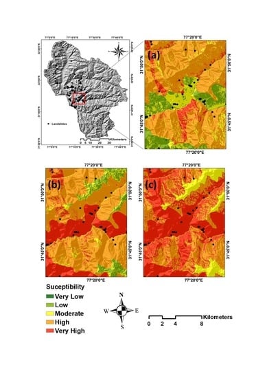
A Hybrid Spatial Multi-Criteria Evaluation Method for Mapping Landslide Susceptible Areas in Kullu Valley, Himalayas
Abstract
1. Introduction
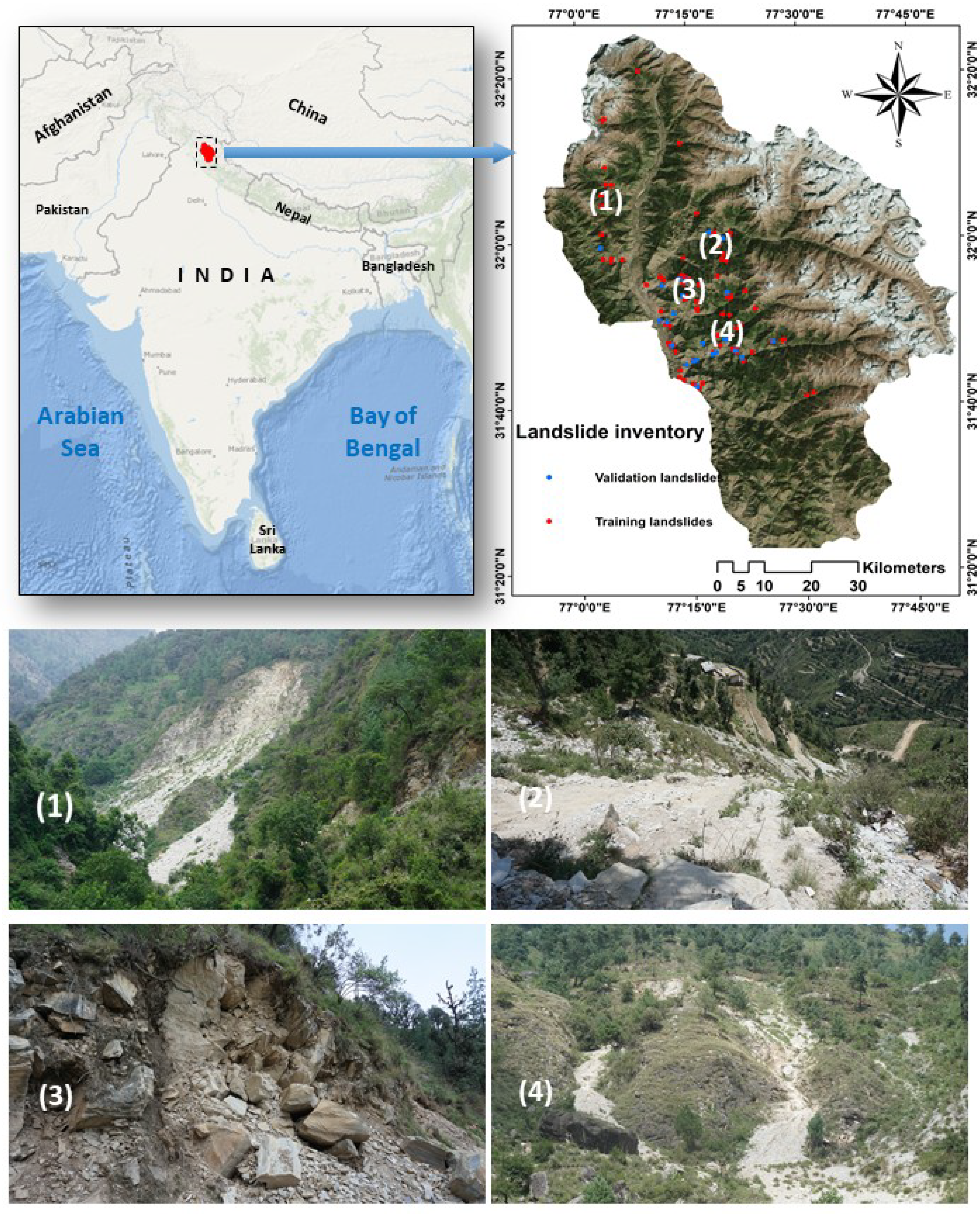
2. Study Area and Inventory Dataset
Landslide Inventory Dataset
3. Workflow
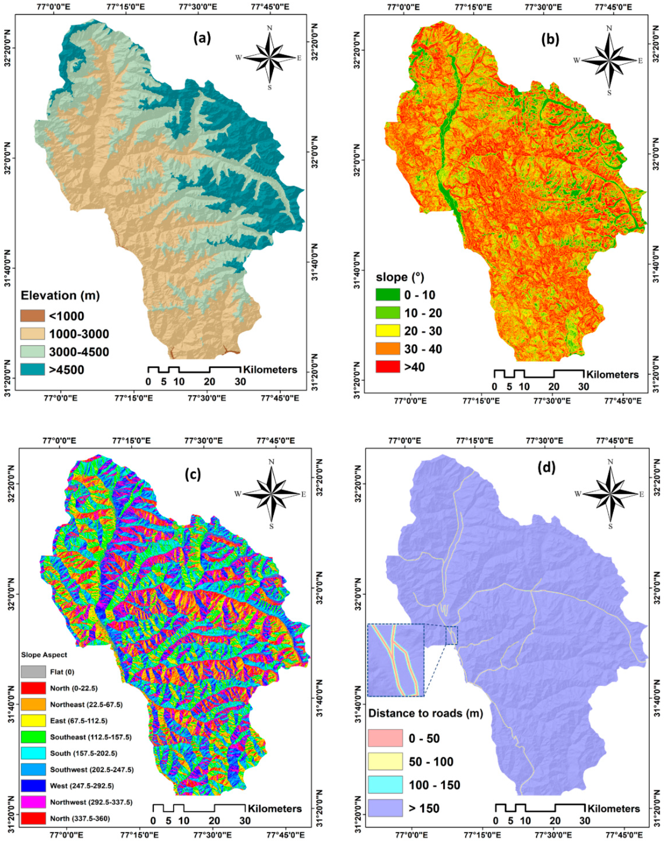
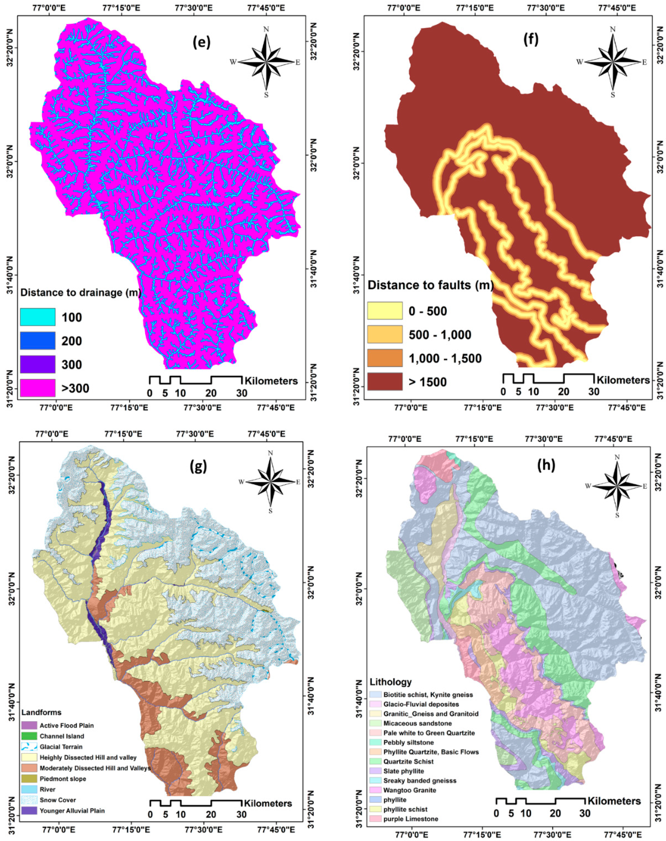
3.1. Conditioning Factors
3.2. Landslide Susceptibility Mapping Using Different Methods
3.2.1. The AHP Method
3.2.2. The FR Method
3.2.3. Hybrid SMCE Method
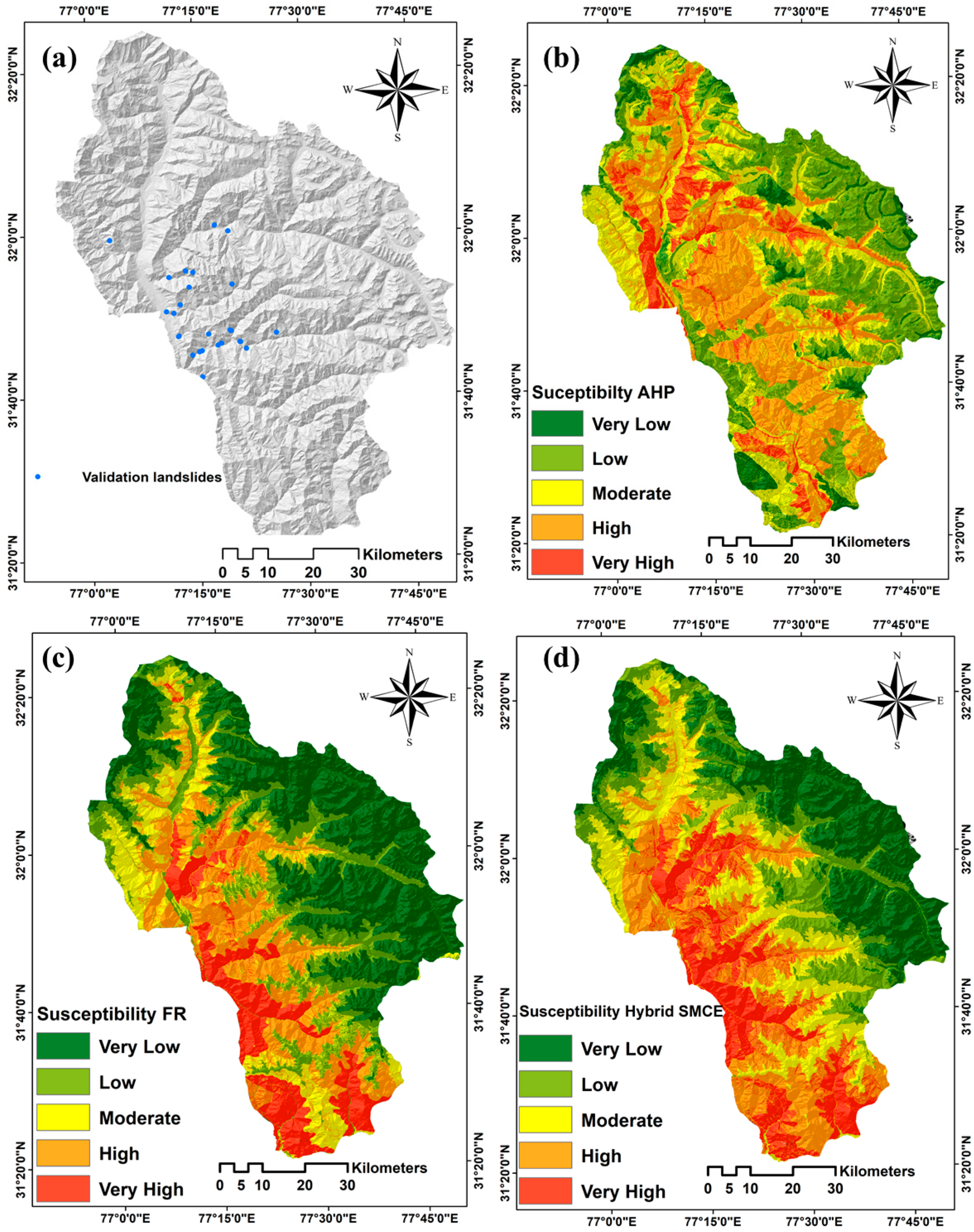
- For the AHP model, we applied two levels of weightings for eight factors and classes. All weights were generated from pairwise comparison matrices of AHP, which is a widely used method in several natural hazard susceptibility modelling and mapping.
- For the FR model, we used only one level of the weights resulting from the FR calculations for each class, and the final landslide susceptibility map was produced from these weights.
- For the hybrid SMCE, we had two different levels of weightings namely factors and classes. As it is an integration methodology of AHP and FR, the resulting weights of AHP were used for the conditioning factors. Furthermore, weightings of the second level hybrid SMCE were from FR.
4. Results and Validation
5. Discussion
6. Conclusions
Author Contributions
Funding
Conflicts of Interest
References
- Mishra, B.K.; Bhattacharjee, D.; Chattopadhyay, A.; Prusty, G. Tectonic and lithologic control over landslide activity within the Larji–Kullu Tectonic Window in the Higher Himalayas of India. Nat. Hazards 2018, 92, 673–697. [Google Scholar] [CrossRef]
- Feizizadeh, B.; Jankowski, P.; Blaschke, T. A GIS based spatially-explicit sensitivity and uncertainty analysis approach for multi-criteria decision analysis. Comput. Geosci. 2014, 64, 81–95. [Google Scholar] [CrossRef]
- Bedia, J.; Herrera, S.; Camia, A.; Moreno, J.M.; Gutiérrez, J.M. Forest fire danger projections in the mediterranean using ensembles regional climate change scenarios. Clim. Chang. 2014, 122, 185–199. [Google Scholar] [CrossRef]
- Niu, Q.; Dang, X.; Li, Y.; Zhang, Y.; Lu, X.; Gao, W. Suitability analysis for topographic factors in loess landslide research: A case study of Gangu county, China. Environ. Earth Sci. 2018, 77, 294. [Google Scholar] [CrossRef]
- Ghorbanzadeh, O.; Feizizadeh, B.; Blaschke, T. An interval matrix method used to optimize the decision matrix in AHP technique for land subsidence susceptibility mapping. Environ. Earth Sci. 2018, 77, 584. [Google Scholar] [CrossRef]
- Feizizadeh, B.; Ghorbanzadeh, O. GIS-based interval pairwise comparison matrices as a novel approach for optimizing an analytical hierarchy process and multiple criteria weighting. GI_Forum 2017, 1, 27–35. [Google Scholar] [CrossRef]
- Rossi, M.; Guzzetti, F.; Reichenbach, P.; Mondini, A.C.; Peruccacci, S. Optimal landslide susceptibility zonation based on multiple forecasts. Geomorphology 2010, 114, 129–142. [Google Scholar] [CrossRef]
- Czikhardt, R.; Papco, J.; Bakon, M.; Liscak, P.; Ondrejka, P.; Zlocha, M. Ground stability monitoring of undermined and landslide prone areas by means of sentinel-1 multi-temporal InSAR, case study from Slovakia. Geosciences 2017, 7, 87. [Google Scholar] [CrossRef]
- Martha, T.R.; Westen, C.J.V.; Kerle, N. Landslide hazard and risk assessment using semi-automatically created landslide inventories. Geomorphology 2013, 184, 139–150. [Google Scholar] [CrossRef]
- Aleotti, P.; Chowdhury, R. Landslide hazard assessment: Summary review and new perspectives. Bull. Eng. Geol. Environ. 1999, 58, 21–44. [Google Scholar] [CrossRef]
- Trigila, A.; Frattini, P.; Casagli, N.; Catani, F.; Crosta, G.; Esposito, C.; Iadanza, C.; Lagomarsino, D.; Mugnozza, G.S.; Segoni, S. Landslide susceptibility mapping at national scale: The Italian case study. In Landslide Science and Practice; Springer: Berlin/Heidelberg, Germany, 2013; pp. 287–295. [Google Scholar]
- Hasekioğulları, G.D.; Ercanoglu, M. A new approach to use AHP in landslide susceptibility mapping: A case study at Yenice (Karabuk, NW Turkey). Nat. Hazards 2012, 63, 1157–1179. [Google Scholar] [CrossRef]
- Ghorbanzadeh, O.; Feizizadeh, B.; Blaschke, T. Multi-criteria risk evaluation by integrating an analytical network process approach into GIS-based sensitivity and uncertainty analyses. Geomat. Nat. Hazards Risk 2018, 9, 127–151. [Google Scholar] [CrossRef]
- Pirnazar, M.; Karimi, A.Z.; Feizizadeh, B.; Ostad-Ali-Askari, K.; Eslamian, S.; Hasheminasab, H.; Ghorbanzadeh, O.; Hamedani, M.H. Assessing flood hazard using GIS based multi-criteria decision making approach; study area: East-Azerbaijan province (Kaleybar Chay Basin). J. Flood Eng. 2017, 8, 203–223. [Google Scholar]
- Van Westen, C. Statistical landslide hazard analysis. ILWIS 1997, 2, 73–84. [Google Scholar]
- Hong, H.; Pradhan, B.; Sameen, M.I.; Chen, W.; Xu, C. Spatial prediction of rotational landslide using geographically weighted regression, logistic regression, and support vector machine models in Xing Guo area (China). Geomat. Nat. Hazards Risk 2017, 8, 1997–2022. [Google Scholar] [CrossRef]
- Pourghasemi, H.R.; Rahmati, O. Prediction of the landslide susceptibility: Which algorithm, which precision? Catena 2018, 162, 177–192. [Google Scholar] [CrossRef]
- Chen, K.; Blong, R.; Jacobson, C. MCE-RISK: Integrating multicriteria evaluation and GIS for risk decision-making in natural hazards. Environ. Model. Softw. 2001, 16, 387–397. [Google Scholar] [CrossRef]
- Kritikos, T.R.; Davies, T.R. Gis-based multi-criteria decision analysis for landslide susceptibility mapping at northern evia, greece [gis-basierte multikriterielle entscheidungsanalysen zur kartierung von massenverlagerungspotenzialen im nördlichen evia, griechenland]. Z. Dtsch. Ges. Geowiss. 2011, 162, 421–434. [Google Scholar] [CrossRef]
- Shahabi, H.; Hashim, M. Landslide susceptibility mapping using GIS-based statistical models and remote sensing data in tropical environment. Sci. Rep. 2015, 5, 9899. [Google Scholar] [CrossRef] [PubMed]
- Wang, Q.; Li, W. A GIS-based comparative evaluation of analytical hierarchy process and frequency ratio models for landslide susceptibility mapping. Phys. Geogr. 2017, 38, 318–337. [Google Scholar] [CrossRef]
- Sharma, S.; Mahajan, A. A comparative assessment of information value, frequency ratio and analytical hierarchy process models for landslide susceptibility mapping of a Himalayan watershed, India. Bull. Eng. Geol. Environ. 2018, 1–18. [Google Scholar] [CrossRef]
- Günther, A.; Van Den Eeckhaut, M.; Malet, J.-P.; Reichenbach, P.; Hervás, J. Climate-physiographically differentiated Pan-European landslide susceptibility assessment using spatial multi-criteria evaluation and transnational landslide information. Geomorphology 2014, 224, 69–85. [Google Scholar] [CrossRef]
- Meena, S.R.; Ghorbanzadeh, O.; Blaschke, T. A comparative study of statistics-based landslide susceptibility models: A case study of the region affected by the Gorkha Earthquake in Nepal. ISPRS Int. J. Geo-Inf. 2019, 8, 94. [Google Scholar] [CrossRef]
- Shahabi, H.; Khezri, S.; Ahmad, B.B.; Hashim, M. Landslide susceptibility mapping at central Zab basin, Iran: A comparison between analytical hierarchy process, frequency ratio and logistic regression models. Catena 2014, 115, 55–70. [Google Scholar] [CrossRef]
- Varnes, D.J. Slope movement types and processes. Transp. Res. Board Spec. Rep. 1978, 176, 11–33. [Google Scholar]
- Meena, S.R.; Mishra, B.K. Landslide risk assessment of Kullu valley using frequency ratio methods and its controlling mechanism, Himachal Himalayas, India. In Proceedings of the INQUIMUS 2018 workshop: Methods and Tools to Assess Multi-Hazard Risk, Vulnerability and Resilience, Venice, Italy, 3–5 December 2018. [Google Scholar]
- Ghorbanzadeh, O.; Blaschke, T.; Gholamnia, K.; Meena, S.R.; Tiede, D.; Aryal, J. Evaluation of different machine learning methods and deep-learning convolutional neural networks for landslide detection. Remote Sens. 2019, 11, 196. [Google Scholar] [CrossRef]
- Meena, S.R. Web based landslide management system for Nepal. In Proceedings of the 33rd Himalaya-Karakorum-Tibet Workshop (HKT), Lausanne, Switzerland, 10–12 September 2018; pp. 109–110. [Google Scholar]
- Pisano, L.; Zumpano, V.; Malek, Ž.; Rosskopf, C.M.; Parise, M. Variations in the susceptibility to landslides, as a consequence of land cover changes: A look to the past, and another towards the future. Sci. Total Environ. 2017, 601, 1147–1159. [Google Scholar] [CrossRef] [PubMed]
- Cruden, D.M.; Varnes, D.J. Landslide Types and Processes. In Landslides: Investigation and Mitigation; Transportation Research Board: Leipzig, Germany, 1996; Volume 247, pp. 36–75. [Google Scholar]
- Guzzetti, F.; Mondini, A.C.; Cardinali, M.; Fiorucci, F.; Santangelo, M.; Chang, K.-T. Landslide inventory maps: New tools for an old problem. Earth-Sci. Rev. 2012, 112, 42–66. [Google Scholar] [CrossRef]
- Basheer, I.A.; Hajmeer, M. Artificial neural networks: Fundamentals, computing, design, and application. J. Microbiol. Methods 2000, 43, 3–31. [Google Scholar] [CrossRef]
- Pham, B.T.; Prakash, I.; Khosravi, K.; Chapi, K.; Trong, P.; Trinh, T.Q.N.; Hosseini, S.V.; Bui, D.T. A comparison of Support Vector Machines and Bayesian algorithms for landslide susceptibility modeling. Geocarto Int. 2018, 1–23. [Google Scholar] [CrossRef]
- Feizizadeh, B.; Blaschke, T. An uncertainty and sensitivity analysis approach for GIS-based multicriteria landslide susceptibility mapping. Int. J. Geogr. Inf. Sci. 2014, 28, 610–638. [Google Scholar] [CrossRef] [PubMed]
- Yu, B.; Chen, F.; Muhammad, S. Analysis of satellite-derived landslide at central Nepal from 2011 to 2016. Environ. Earth Sci. 2018, 77, 331. [Google Scholar] [CrossRef]
- Raja, N.B.; Įiįek, I.; Türkoğlu, N.; Aydin, O.; Kawasaki, A. Correction to: Landslide susceptibility mapping of the sera river basin using logistic regression model. Nat. Hazards 2018, 91, 1423. [Google Scholar] [CrossRef]
- Gökceoglu, C.; Aksoy, H. Landslide susceptibility mapping of the slopes in the residual soils of the Mengen region (Turkey) by deterministic stability analyses and image processing techniques. Eng. Geol. 1996, 44, 147–161. [Google Scholar] [CrossRef]
- Yalcin, A.; Bulut, F. Landslide susceptibility mapping using GIS and digital photogrammetric techniques: A case study from Ardesen (NE-Turkey). Nat. Hazards 2007, 41, 201–226. [Google Scholar] [CrossRef]
- Devkota, K.C.; Regmi, A.D.; Pourghasemi, H.R.; Yoshida, K.; Pradhan, B.; Ryu, I.C.; Dhital, M.R.; Althuwaynee, O.F. Landslide susceptibility mapping using certainty factor, index of entropy and logistic regression models in GIS and their comparison at Mugling–Narayanghat road section in Nepal Himalaya. Nat. Hazards 2013, 65, 135–165. [Google Scholar] [CrossRef]
- Chen, W.; Pourghasemi, H.R.; Naghibi, S.A. A comparative study of landslide susceptibility maps produced using support vector machine with different kernel functions and entropy data mining models in china. Bull. Eng. Geol. Environ. 2018, 77, 647–664. [Google Scholar] [CrossRef]
- Regmi, A.D.; Dhital, M.R.; Zhang, J.-Q.; Su, L.-J.; Chen, X.-Q. Landslide susceptibility assessment of the region affected by the 25 April 2015 Gorkha earthquake of Nepal. J. Mt. Sci. 2016, 13, 1941–1957. [Google Scholar] [CrossRef]
- Saaty, T.L.; Vargas, L.G. Hierarchical analysis of behavior in competition: Prediction in chess. Behav. Sci. 1980, 25, 180–191. [Google Scholar] [CrossRef]
- Cabrera-Barona, P.; Ghorbanzadeh, O. Comparing classic and interval analytical hierarchy process methodologies for measuring area-level deprivation to analyze health inequalities. Int. J. Environ. Res. Public Health 2018, 15, 140. [Google Scholar] [CrossRef]
- Ghorbanzadeh, O.; Moslem, S.; Blaschke, T.; Duleba, S. Sustainable urban transport planning considering different stakeholder groups by an interval-AHP decision support model. Sustainability 2018, 11, 9. [Google Scholar] [CrossRef]
- Ayalew, L.; Yamagishi, H.; Ugawa, N. Landslide susceptibility mapping using GIS-based weighted linear combination, the case in Tsugawa area of Agano River, Niigata Prefecture, Japan. Landslides 2004, 1, 73–81. [Google Scholar] [CrossRef]
- Saaty, T.L.; Vargas, L.G. Inconsistency and rank preservation. J. Math. Psychol. 1984, 28, 205–214. [Google Scholar] [CrossRef]
- Sahnoun, H.; Serbaji, M.M.; Karray, B.; Medhioub, K. GIS and multi-criteria analysis to select potential sites of agro-industrial complex. Environ. Earth Sci. 2012, 66, 2477–2489. [Google Scholar] [CrossRef]
- Saaty, T.L. A scaling method for priorities in hierarchical structures. J. Math. Psychol. 1977, 15, 234–281. [Google Scholar] [CrossRef]
- Pourghasemi, H.; Pradhan, B.; Gokceoglu, C.; Moezzi, K.D. Landslide susceptibility mapping using a spatial multi criteria evaluation model at Haraz Watershed, Iran. In Terrigenous Mass Movements; Springer: Berlin/Heidelberg, Germany, 2012; pp. 23–49. [Google Scholar]
- Malczewski, J.; Rinner, C. Multicriteria Decision Analysis in Geographic Information Science; Springer: New York, NY, USA, 2016. [Google Scholar]
- Ghorbanzadeh, O.; Blaschke, T. Wildfire susceptibility evaluation by integrating an analytical network process approach into GIS-based analyses. Int. J. Adv. Sci. Eng. Technol. 2018, 6, 48–53. [Google Scholar]
- Pradhan, B. Landslide susceptibility mapping of a catchment area using frequency ratio, fuzzy logic and multivariate logistic regression approaches. J. Indian Soc. Remote Sens. 2010, 38, 301–320. [Google Scholar] [CrossRef]
- Mahalingam, R.; Olsen, M.J.; O’Banion, M.S. Evaluation of landslide susceptibility mapping techniques using lidar-derived conditioning factors (Oregon case study). Geomat. Nat. Hazards Risk 2016, 7, 1884–1907. [Google Scholar] [CrossRef]
- Demir, G.; Aytekin, M.; Akgün, A.; Ikizler, S.B.; Tatar, O. A comparison of landslide susceptibility mapping of the eastern part of the North Anatolian Fault Zone (Turkey) by likelihood-frequency ratio and analytic hierarchy process methods. Nat. Hazards 2013, 65, 1481–1506. [Google Scholar] [CrossRef]
- Malczewski, J. GIS and Multicriteria Decision Analysis; J. Wiley & Sons: New York, NY, USA, 1999; p. 392. [Google Scholar]
- Rahman, R.; Saha, S. Remote sensing, spatial multi criteria evaluation (SMCE) and analytical hierarchy process (AHP) in optimal cropping pattern planning for a flood prone area. J. Spat. Sci. 2008, 53, 161–177. [Google Scholar] [CrossRef]
- Pourghasemi, H.; Moradi, H.; Aghda, S.F.; Gokceoglu, C.; Pradhan, B. GIS-based landslide susceptibility mapping with probabilistic likelihood ratio and spatial multi-criteria evaluation models (North of Tehran, Iran). Arab. J. Geosci. 2014, 7, 1857–1878. [Google Scholar] [CrossRef]
- Abella, E.C.; Van Westen, C. Generation of a landslide risk index map for Cuba using spatial multi-criteria evaluation. Landslides 2007, 4, 311–325. [Google Scholar] [CrossRef]
- Ghorbanzadeh, O.; Blaschke, T.; Aryal, J.; Gholaminia, K. A new GIS-based technique using an adaptive neuro-fuzzy inference system for land subsidence susceptibility mapping. J. Spat. Sci. 2018, 1–17. [Google Scholar] [CrossRef]
- Calvello, M.; Ciurleo, M. Optimal use of thematic maps for landslide susceptibility assessment by means of statistical analyses: Case study of shallow landslides in fine-grained soils. In Landslides and Engineered Slopes. Experience, Theory and Practice; CRC Press: Boca Raton, FL, USA, 2016; pp. 537–544. [Google Scholar]
- Sezer, E.A.; Pradhan, B.; Gokceoglu, C. Manifestation of an adaptive neuro-fuzzy model on landslide susceptibility mapping: Klang valley, Malaysia. Expert Syst. Appl. 2011, 38, 8208–8219. [Google Scholar] [CrossRef]
- Das, I.; Stein, A.; Kerle, N.; Dadhwal, V.K. Landslide susceptibility mapping along road corridors in the Indian Himalayas using Bayesian logistic regression models. Geomorphology 2012, 179, 116–125. [Google Scholar] [CrossRef]
- Park, S.; Choi, C.; Kim, B.; Kim, J. Landslide susceptibility mapping using frequency ratio, analytic hierarchy process, logistic regression, and artificial neural network methods at the Inje area, Korea. Environ. Earth Sci. 2013, 68, 1443–1464. [Google Scholar] [CrossRef]
- Schicker, R.; Moon, V. Comparison of bivariate and multivariate statistical approaches in landslide susceptibility mapping at a regional scale. Geomorphology 2012, 161, 40–57. [Google Scholar] [CrossRef]
- Capitani, M.; Ribolini, A.; Bini, M. The slope aspect: A predisposing factor for landsliding? C. R. Geosci. 2013, 345, 427–438. [Google Scholar] [CrossRef]
- Borrelli, L.; Ciurleo, M.; Gullà, G. Shallow landslide susceptibility assessment in granitic rocks using GIS-based statistical methods: The contribution of the weathering grade map. Landslides 2018, 15, 1127–1142. [Google Scholar] [CrossRef]
- Ozdemir, A.; Altural, T. A comparative study of frequency ratio, weights of evidence and logistic regression methods for landslide susceptibility mapping: Sultan Mountains, SW Turkey. J. Asian Earth Sci. 2013, 64, 180–197. [Google Scholar] [CrossRef]
| Importance | Definition | Explanation |
|---|---|---|
| 1 | Equal importance | Contribution to objective is equal |
| 3 | Moderate importance | The attribute is slightly favoured over another |
| 5 | Strong importance | The attribute is strongly favoured over another |
| 7 | Very strong importance | The attribute is very strongly favoured over another |
| 9 | Extreme importance | Evidence favouring one attribute is of the highest possible order of affirmation |
| 2, 4, 6, 8 | Intermediate values | When compromise is needed |
| Factors & AHP Weights | Classes | Pixels of Each Class | % of Pixels | Landslide Pixels | % of Pixels | FR | AHP Weights | CR |
|---|---|---|---|---|---|---|---|---|
| Landforms | Active flood plain | 1242 | 0.02 | 0 | 0 | 0 | 0.063 | |
| 0.112 | Channel island | 93 | 0 | 0 | 0 | 0 | 0.07 | |
| Glacial terrain | 81,464 | 1.33 | 0 | 0 | 0 | 0.068 | ||
| Highly dissected hill and valley | 115,218 | 1.88 | 0 | 0 | 0 | 0.068 | ||
| Moderately dissected hill and valley | 732,590 | 11.98 | 26,100 | 33.72 | 0.68 | 0.174 | ||
| Piedmont slope | 2,111,092 | 34.52 | 0 | 0 | 0 | 0.086 | ||
| River | 2501 | 0.04 | 0 | 0 | 0 | 0.090 | ||
| Snow cover | 3,027,191 | 49.5 | 49,500 | 63.95 | 0.31 | 0.270 | ||
| Younger Alluvial Plain | 44,690 | 0.73 | 1800 | 2.33 | 0.01 | 0.109 | ||
| 0.527 | ||||||||
| Distance to fault (m) | (1) 0–500 | 1,885,370 | 30.83 | 38,700 | 50 | 0.35 | 0.641 | |
| 0.056 | 500–1000 | 1,125,372 | 18.4 | 22,500 | 29.07 | 0.34 | 0.221 | |
| 1000–1500 | 474,307 | 7.76 | 7200 | 9.3 | 0.26 | 0.086 | ||
| >1500 | 2,631,091 | 43.02 | 9000 | 11.63 | 0.06 | 0.050 | ||
| 0.03 | ||||||||
| Distance to drainage (m) | <100 | 13,05,283 | 21.34 | 35,100 | 45.35 | 0.42 | 0.41 | |
| 0.085 | 100–200 | 1,097,497 | 17.94 | 19,800 | 25.58 | 0.28 | 0.254 | |
| 200–300 | 947,452 | 15.49 | 9000 | 11.63 | 0.15 | 0.152 | ||
| >300 | 1,999,494 | 32.69 | 9000 | 11.63 | 0.07 | 0.078 | ||
| 0.032 | ||||||||
| Slope ° (%) | 0–10 | 396,204 | 6.49 | 900 | 1.16 | 0.04 | 0.053 | |
| 0.212 | 10–20 | 986,022 | 16.15 | 5400 | 6.98 | 0.1 | 0.067 | |
| 20–30 | 1,593,420 | 26.1 | 10,800 | 13.95 | 0.13 | 0.235 | ||
| 30–40 | 1,696,257 | 27.79 | 23,400 | 30.23 | 0.25 | 0.325 | ||
| >40 | 1,432,378 | 23.47 | 36,900 | 47.67 | 0.48 | 0.320 | ||
| 0.158 | ||||||||
| Elevation (m) | <1000 | 12,841 | 0.21 | 0 | 0 | 0 | 0.067 | |
| 0.184 | 1000–3000 | 2,662,889 | 43.54 | 67,500 | 87.21 | 0.85 | 0.147 | |
| 3000–4500 | 2,127,205 | 34.78 | 9900 | 12.79 | 0.16 | 0.493 | ||
| >4500 | 1,313,227 | 21.47 | 0 | 0 | 0 | 0.291 | ||
| 0.006 | ||||||||
| Aspect | Flat | 201 | 0 | 0 | 0 | 0 | 0.064 | |
| 0.141 | North | 358,109 | 5.87 | 1800 | 2.33 | 0.05 | 0.047 | |
| Northeast | 704,069 | 11.53 | 4500 | 5.81 | 0.06 | 0.051 | ||
| East | 708,560 | 11.61 | 5400 | 6.98 | 0.07 | 0.071 | ||
| southeast | 753,766 | 12.35 | 16,200 | 20.93 | 0.21 | 0.014 | ||
| South | 799,804 | 13.1 | 21,600 | 27.91 | 0.26 | 0.016 | ||
| Southwest | 854,910 | 14.01 | 18,000 | 23.26 | 0.21 | 0.018 | ||
| West | 814,385 | 13.34 | 5400 | 6.98 | 0.06 | 0.015 | ||
| Northwest | 752,598 | 12.33 | 3600 | 4.65 | 0.05 | 0.08 | ||
| North | 357,879 | 5.86 | 900 | 1.16 | 0.02 | 0.062 | ||
| 0.092 | ||||||||
| Distance to roads (m) | <50 | 169,279 | 2.77 | 4500 | 5.81 | 0.21 | 0.061 | |
| 0.032 | 50–100 | 163,787 | 2.68 | 9000 | 11.63 | 0.44 | 0.095 | |
| 100–150 | 158,579 | 2.59 | 5400 | 6.98 | 0.27 | 0.315 | ||
| >150 | 5,624,495 | 91.96 | 58,500 | 75.58 | 0.08 | 0.527 | ||
| 0.07 | ||||||||
| Lithology | Biotitie schist, Kynite gneiss | 99,355 | 1.63 | 0 | 0.00 | 0.00 | 0.043 | |
| 0.101 | Glacio-Fluvial deposites | 1517 | 0.02 | 0 | 0.00 | 0.00 | 0.042 | |
| Granitic_Gneiss and Granitoid | 114,826 | 1.88 | 0 | 0.00 | 0.00 | 0.045 | ||
| Micaceous sandstone | 1,122,715 | 18.38 | 39,600 | 51.16 | 0.17 | 0.252 | ||
| Pale white to Green Quartzite | 151,271 | 2.48 | 0 | 0.00 | 0.00 | 0.073 | ||
| Pebbly siltstone | 134,854 | 2.21 | 2700 | 3.49 | 0.10 | 0.07 | ||
| Phyllite Quartzite, Basic Flows | 12,408 | 0.20 | 0 | 0.00 | 0.00 | 0.083 | ||
| Quartzite Schist | 206,344 | 3.38 | 2700 | 3.49 | 0.06 | 0.064 | ||
| Slate phyllite | 957,212 | 15.67 | 1800 | 2.33 | 0.01 | 0.058 | ||
| Sreaky banded gneisss | 203,907 | 3.34 | 5400 | 6.98 | 0.13 | 0.049 | ||
| Wangtoo Granite | 2,407,184 | 39.41 | 6300 | 8.14 | 0.01 | 0.053 | ||
| phyllite | 299,137 | 4.90 | 1800 | 2.33 | 0.03 | 0.047 | ||
| phyllite schist | 156,698 | 2.57 | 15,300 | 19.77 | 0.46 | 0.063 | ||
| purple Limestone | 239,881 | 3.93 | 1800 | 2.33 | 0.04 | 0.052 | ||
| 0.016 |
© 2019 by the authors. Licensee MDPI, Basel, Switzerland. This article is an open access article distributed under the terms and conditions of the Creative Commons Attribution (CC BY) license (http://creativecommons.org/licenses/by/4.0/).
Share and Cite
Meena, S.R.; Mishra, B.K.; Tavakkoli Piralilou, S. A Hybrid Spatial Multi-Criteria Evaluation Method for Mapping Landslide Susceptible Areas in Kullu Valley, Himalayas. Geosciences 2019, 9, 156. https://doi.org/10.3390/geosciences9040156
Meena SR, Mishra BK, Tavakkoli Piralilou S. A Hybrid Spatial Multi-Criteria Evaluation Method for Mapping Landslide Susceptible Areas in Kullu Valley, Himalayas. Geosciences. 2019; 9(4):156. https://doi.org/10.3390/geosciences9040156
Chicago/Turabian StyleMeena, Sansar Raj, Brijendra Kumar Mishra, and Sepideh Tavakkoli Piralilou. 2019. "A Hybrid Spatial Multi-Criteria Evaluation Method for Mapping Landslide Susceptible Areas in Kullu Valley, Himalayas" Geosciences 9, no. 4: 156. https://doi.org/10.3390/geosciences9040156
APA StyleMeena, S. R., Mishra, B. K., & Tavakkoli Piralilou, S. (2019). A Hybrid Spatial Multi-Criteria Evaluation Method for Mapping Landslide Susceptible Areas in Kullu Valley, Himalayas. Geosciences, 9(4), 156. https://doi.org/10.3390/geosciences9040156


