Article

The University of the West Indies-Seismic Research Centre Volcano Monitoring Network: Evolution since 1953 and Challenges in Maintaining a State-of-the-Art Network in a Small Island Economy

Seismic Research Centre, The University of the West Indies, Gordon Street, St Augustine, Trinidad, Trinidad and Tobago
*
Author to whom correspondence should be addressed.
Geosciences 2019, 9(2), 71; https://doi.org/10.3390/geosciences9020071
Submission received: 7 December 2018 / Revised: 15 January 2019 / Accepted: 21 January 2019 / Published: 30 January 2019
(This article belongs to the Special Issue Volcano Monitoring – Placing the Finger on the Pulse)

Abstract

:
The Seismic Research Centre (SRC), formerly known as the Seismic Research Unit (SRU), of the University of the West Indies is located on the island of Trinidad in the Eastern Caribbean. The centre has been operating its volcanological and seismological surveillance network since 1953. Since that time, the network has been upgraded five times resulting in five generations of seismic network topologies (i.e., Classes). Class 1 consisted of autonomously operated photographic recording stations, a purely analogue configuration. From Class 2 to Class 5 (current class) the network has continuously grown in scope, sophistication and capability. The evolution of the network was carried out using a combination of state-of-the-art instruments as well as trailing edge technology (e.g., analogue transmission) used in a manner that allows for sustainability. In this way, the network has been able to address the scientific and technical challenges associated with operating in an island arc subduction zone which is exposed to other natural hazards such as hurricanes. To counter its operational constrains the SRC has developed several strategies, which contribute to: (i) expand the network to meet the demand for more timely and accurate surveillance of geohazards, (ii) broaden the range of monitoring techniques (e.g., cGPS, geochemical), (iii) capture research grade scientific data and (iv) reduce operational costs.

1. Introduction

The Lesser Antilles arc has attracted volcanologists, for over a hundred years, and their work has contributed to the advancement of volcanology both in term of concepts and monitoring. A major stimulus to heighten the interest was the 1902/05/08 catastrophic eruption of Mount Pelée that resulted in the death of 30,000 inhabitants of the “Petite Paris” of the Lesser Antilles, which was, at the time, St-Pierre, the Capital city of Martinique. Boudon, et al. [1] described this event as “the most lethal eruption driven by a primary volcanic event in the world that century, and one of the most fatal in recorded history”. In the wake of that catastrophe, at the end of 1902, the world’s second volcano observatory was built under the leadership of Alfred Lacroix at Morne des Cadets, located about 8.5 km away from the volcano. The observatory was established just in time to monitor the dome forming phases of the 1902–1905 eruption [2].
Continuous monitoring of the seismo-volcanic hazard in the English-speaking Lesser Antilles was a response to the 1950–1951 damage-causing series of volcanic earthquakes in St Kitts and Nevis [3,4]. As a consequence of this crisis and similar, earlier, periodic crises in Montserrat and other British territories, the Volcanological Research Department (VRD) a regional monitoring agency initially for volcanic activity was established associated with the Imperial College of the Tropical Agriculture in Trinidad. The office was first based in the Port of Spain. The occurrence of damaging earthquakes north-west of Saint Lucia, in 1953, and north of Trinidad, in 1954, highlighted the broader nature of the earthquake hazard and, by the end of 1956, the monitoring agency was being referred to as the Seismology Unit, becoming over time the Seismic Research Unit (SRU) to reflect the fact that all earthquakes would also be monitored. In 1959, the SRU moved to its own custom built office, on its own property in St. Augustine, associated with the University College of the West Indies and fully under the umbrella of the University of the West Indies (UWI), in 1962, when the St. Augustine Campus was established [4]. In 2008 the SRU became the Seismic Research Centre (SRC http://uwiseismic.com/) to more accurately reflect its status within The UWI system. This monitoring centre was the first in the region to operate a continuous seismograph network with seven stations by 1957 [5,6]. These stations along with the two seismographs operated by the French observatories in Guadeloupe and Martinique gave, a total of nine short-period seismographs in operation in the region [5,6].
Since its establishment, the primary goals of the SRC have been to:
  • monitor both earthquakes and volcanoes and, since the late 1990s, tsunamis in the Commonwealth Eastern Caribbean;
  • conduct a continuous program of volcanic and seismic hazard assessment in all contributing countries;
  • liaise with 11 separate governments of countries which host 17 of the 21 known, live volcanoes in the Lesser Antilles;
  • carry out education and outreach activities and provide consultancy services.
This article provides an overview of the evolution and current state of the SRC monitoring network as it delivers on its mission to monitor the 17 volcanoes under its umbrella. It also outlines challenges that this mid-size regional institution faces. We first start by introducing the regional geological context of the Lesser Antilles volcanic arc (Section 2). Then we present a temporal evolution of the monitoring efforts of the SRC, with emphasis on monitoring of the active submarine volcano Kick-’em-Jenny (KeJ). In this review we do not include the evolution of the network on Montserrat although it currently falls under our purview, as it is dealt with elsewhere (Stewart et al. in prep.). Section 3 describes the evolution of the SRC’s seismic monitoring network over its 65 years of existence with a non-digital era (analogue and hybrid system) then gradually superseded by a digital seismic network. Section 4 describes the improvement of volcano monitoring along the arc by the addition of new geophysical techniques such as continuous Global Positioning System (cGPS) and Interferometric Synthetic Aperture Radar (InSAR), as well as improvements in gas and temperature monitoring of geothermal areas. Information on swath bathymetry surveys is also presented in Section 4. Section 5 discusses the current challenge that the SRC has to face in a challenging economic environment, where support for a volcano monitoring network does not appear to be a priority for the territories that contribute the budget of the Centre. Section 6 concludes the article.

2. Geological Context of the Lesser Antilles Volcanic Arc

The Lesser Antilles volcanoes form an arcuate chain of both submarine and subaerial volcanoes that runs over 850 km from Sombrero in the north to Grenada in the south. Along this chain, there are 21 volcanic centres currently considered live volcanoes (Figure 1 [6]). Among these live volcanoes 20 are subaerial systems and one, Kick-’em-Jenny, is submarine.
The Pleistocene to Holocene Lesser Antilles volcanic arc is a consequence of the slow subduction of the North American (NA) and South American (SA) plates under the Caribbean plate (CA). The convergence rate of the Caribbean plate with respect to the North American Plate is 20.0 ± 2.5 mm year 1 [8]. The oblique convergence rate of the Caribbean Plate with respect to the South American plate ranges from 13 mm year 1 [9] to 20 ± 3 mm year 1 [10]. Feuillet et al. [11] suggested that part of the oblique convergence of the CA towards the NA is accommodated by the en echelon shallow fault system that crosses the inner edge of Lesser Antilles Arc (LAA) between Nevis and Martinique. This accommodating process has led to the generation of several historical earthquakes along the en echelon fault system with some of them triggered in response to historical megathrust events. The latter tend to increase Coulomb stress along these normal faults and therefore induce magma body migration towards shallow depth (i.e., magma chamber and/or to the surface). Conversely, this magma body migration can favor shallow fault activity as well as volcanic unrest either magmatic or non-magmatic. Such a model may explain the triggering of the 1995-to present activity at the Soufrière Hills volcano.
Since the Pleistocene, volcanic activity along the active arc has been constrained to a narrow corridor of 10 km width and can be partitioned into three distinct segments (Figure 1). This segmentation is probably due to tearing and deformation of the subducting slab: (i) the northern segment from Saba to Montserrat; (ii) the middle segment from Guadeloupe to Martinique; (iii) the southern segment from Saint Lucia to Grenada [12,13]. According to these authors partitioning of the live eruptive centres might be directly related to the segmentation of the slab and the variation in the dip-angle of the Wadati-Benioff zone under the arc. Wadge et al. [13] shows that his calculated high values of the local component of the convergence normal to the volcanic front (see Figure 10 in [13]) fit the relative plate motion model proposed by [14]. He therefore suggested that these high values may promote the high magmatic production recorded along the middle segment. Instead the low magmatic production recorded in both the north and the south segments could be explained by the greater obliquity of the slab in these segments of the arc. Another model was proposed by [15] to explain magma production and the location of the basaltic dyke systems that contribute to andesite/dacite lavas along each of the three segments. These authors suggested the role of aseismic non-buoyant ridges being subducted and their location during subduction. Gaps between live volcanic centres along the volcanic front may be explained by the presence of these ridges subducting directly beneath these inactive sectors whereas beneath each active volcanic centre magma production is promoted by the presence of subducting sediment piles deposited in depressions which dehydrate and contribute to the partial melting of the asthenospheric wedge. For example, the abnormally high magma production rate for Dominica over the last 100 kyr compared to the other volcanic islands could be a consequence of its position directly beneath a thick subducting sedimentary pile.

3. 65 Years of Seismic Monitoring

3.1. 1953–2005 Period: Analog and Hybrid Seismic Monitoring Network

During this 52-year period of development we can distinguish 2 phases with each one associated with a particular type of monitoring. The volcano seismic monitoring network may be defined, since its early days by class. A class represents a technological generation of station design. Over its first 52 years, seismic monitoring at SRC may be split into two periods dominated by different kinds of instrumentation. The first phase spanned from 1953 until the beginning of the 1980s with a purely analogue-based monitoring network while the second phase may be described as a transition phase with a hybrid monitoring network. The sections below describe each of these phases.

3.1.1. Analog Phase: 1953–1980

The early analogue phase spanned from 1953 to 1961. The seismic monitoring network was established by the Volcanological Research Department (VRD)/Seismic Research Unit (SRU) associated with the Imperial College of Tropical Agriculture in Trinidad. During the first four years, the network grew to seven analogue stations each equipped with a Willmore photographic seismograph installed in Trinidad, Grenada, St. Vincent, Barbados, Saint Lucia, Dominica and Antigua, with St. Kitts coming on stream in 1959 [5]. In Grenada the station was located 30 km away from KeJ. These stations defined the autonomous analogue network (Class 1 network; Lynch pers. comm). This network was associated with low accuracy in the determination of earthquake phase arrivals and cumbersome data processing. Other monitoring efforts included calorimetry on the volcanic hydrothermal systems, mapping and a seismic catalog compilation.
The next 20-year period i.e., 1961–1980 saw many changes occurring not only in terms of ownership of the network, but also in terms of technology. The network was expanded to 16 additional seismic stations, i.e., the Willmore photographic seismograph associated with newly established radio telemetry transmission capability to stream recorded data to the SRU’s headquarter in St Augustine. Figure 2 is a schematic of the 1971 analogue micro-earthquake network (Class 2 network) established by SRU. In 1975 the monitoring of KeJ and Mt St Catherine was improved following the relocation of the historical GRW station further north, in the vicinity of Mt St Catherine. In the meantime, it was in this period that the SRU’s seismology team started to develop its own earthquake processing algorithm, i.e., WurstMachine, to determine hypocentral coordinates of regional earthquakes [16]. WurstMachine was designed to cater for the limitation of long narrow seismic network such as the Lesser Antilles Arc. Figure 3 describes the seismic data processing performed at SRC using the WurstMachine module. The WurstMachine module is part of a PC-based system referred to as the “Soufrière system” that was developed concurrently [17]. The Soufrière system was designed to: (i) digitize and time stamp the seismic data, which were received via radio telemetry from the remote analogue stations; digitization was done by a 16-channel 12-bit analogue-to-digital PC card at 100 samples per second, (ii) record and process the digitized data and (iii) generate in-house seismic bulletins of regional earthquakes (Figure 4). Thanks to this network SRU’s scientists were able to provide expertise not only to regional contributing states, but also to international scientific community in response to the 1971 and 1979 Soufrière of St Vincent eruption, to the 1974 KeJ eruption, as well as during the 1976–1977 unrest crisis of La Soufrière in Guadeloupe.

3.1.2. Hybrid-Sytem: 1980–2005

During the 1980‘s the network continued to expand and reached a total of 32 stations. According to [3] the network was divided into four sub-networks: Leewards (St Kitts, Nevis, Barbuda and Antigua, Montserrat, with Saba, St Eustatius and St Marteen under special contract); Dominica; Saint Lucia/St. Vincent; South Windward (Grenada and the Grenadines, Barbados, Trinidad and Tobago). The network comprised chiefly analogue stations, with single-component short-period seismometers, mainly L-4C Mark Products and a few SS1-Ranger from Kinemetrics Inc. Sites selected for upgrades had to satisfy criteria, such as a location close to an active volcanic centre, easy access for maintenance, “line-of-sight” for radio transmission purposes, low background seismic noise and low susceptibility to vandalism. In some islands where “line-of-sight” transmission was not feasible between crucial links (e.g., Dominica) telephone lines were used as substitutes. Radio transmitters in the network used an analogue frequency-multiplexed telemetry method. During the 1980’s the “Soufrière” data acquisition system was completed and was used as the main system for recording and processing. The association of analogue seismic station with analogue transmission with the “Soufrière” data acquisition system defined the new hydrid network (Class 3 network). Figure 4 is a schematic of the Class 3 network that was in operation during this period. The network not only improved the monitoring of the live volcanoes, but also enhanced monitoring of seismicity along the arc. However, from the mid-80’s many of the contributing territories underwent economic recession and consequently, the SRC seismic network upgrade slowed commensurate with declining contributions to the SRU’s budget.
At the beginning of the 1990s the network was fully operating with Class 3 stations. However, due to high cost of leased telephone circuits used in the Class 3 network topology the maximum number of stations was limited to about 40. By 1996, dial-up Internet access was already available and this accelerated an initiative to upgrade the “Soufrière” data acquisition system to function as a scalable distributed monitoring system which would facilitate the operation of 15 channels of data per deployment. This upgrade was made possible by the rapid improvements in computer and telecommunication technologies that was taking place at the time. From 1998, a strategic decision was made to enhance the quality of network data through the upgrade of a selected quantity of single-component installations with three-component (x, y, z) broadband (0.03 Hz to 50 Hz) seismometers. These three-component broadband seismometers were funded primarily by the governments of the contributing territories. These instruments were Guralp CMG 40T (30 s period) connected to 16-bit digitizers with Global Positioning System (GPS) synchronization for time stamp. Such instruments comprise the core of the Class 4 stations in what may be described as a hybrid network (Figure 5). In addition, data from the remote field stations (in a sub-network) were transmitted via UHF/VHF radios to their sub-network hub and triggered data packaged in fixed-size (digital) files were sent to SRU’s headquarter by File Transfer Protocole via the Internet (dial-up or persistent service such as ADSL; Figure 5). Furthermore, at SRU headquarter data could be downloaded on-demand from the subnetwork hubs via a machine to machine connection established as needed by the use of analogue telephone (computer) modems.
Beginning in 2001 the monitoring of KeJ volcano was improved following the addition of four new seismic stations to complement the historical GRW station at Mt St Catherine (Figure 6). The new station codes were GRHS (Sauteurs on the north coast of Grenada) that serves as the headquarter of the KeJ sub-network, GRIC (Isle de Caille, southern Grenadines), GRSS (Sisters Islands, southern Grenadines) and GRCU (Carriacou, southern Grenadines). GRHS was equipped with one Guralp CMG-40T (Class 4). The instrumentation at GRIC, GRSS and GRCU consisted of Integra LA100/F single-component short period seismometers.
Class 4 network topology which was introduced in 1998 in Dominica was replicated and optimised throughout the arc to create a hybrid seismic network in the ensuing six years. Figure 7 displays SRU’s hybrid network at the end of 2005 with 10 broadband and three short period monitors. Among these monitors three were located in the Netherland Antillean islands of Saba, St Eustatius and St Maarten (Figure 7).

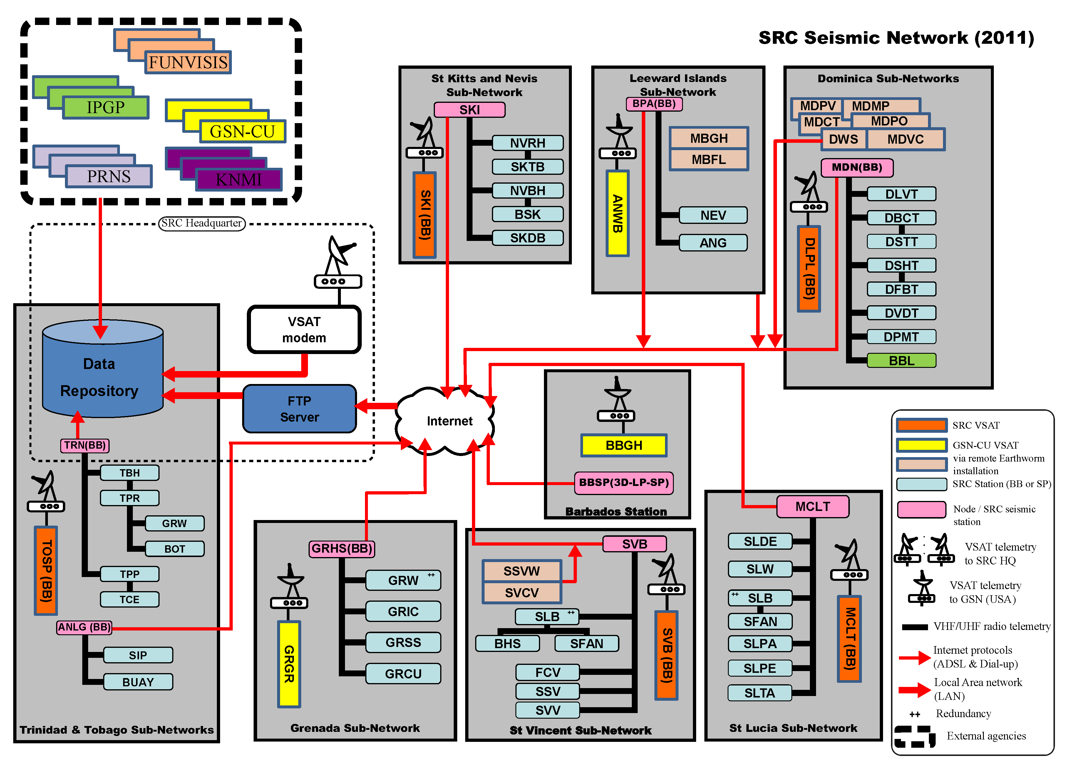
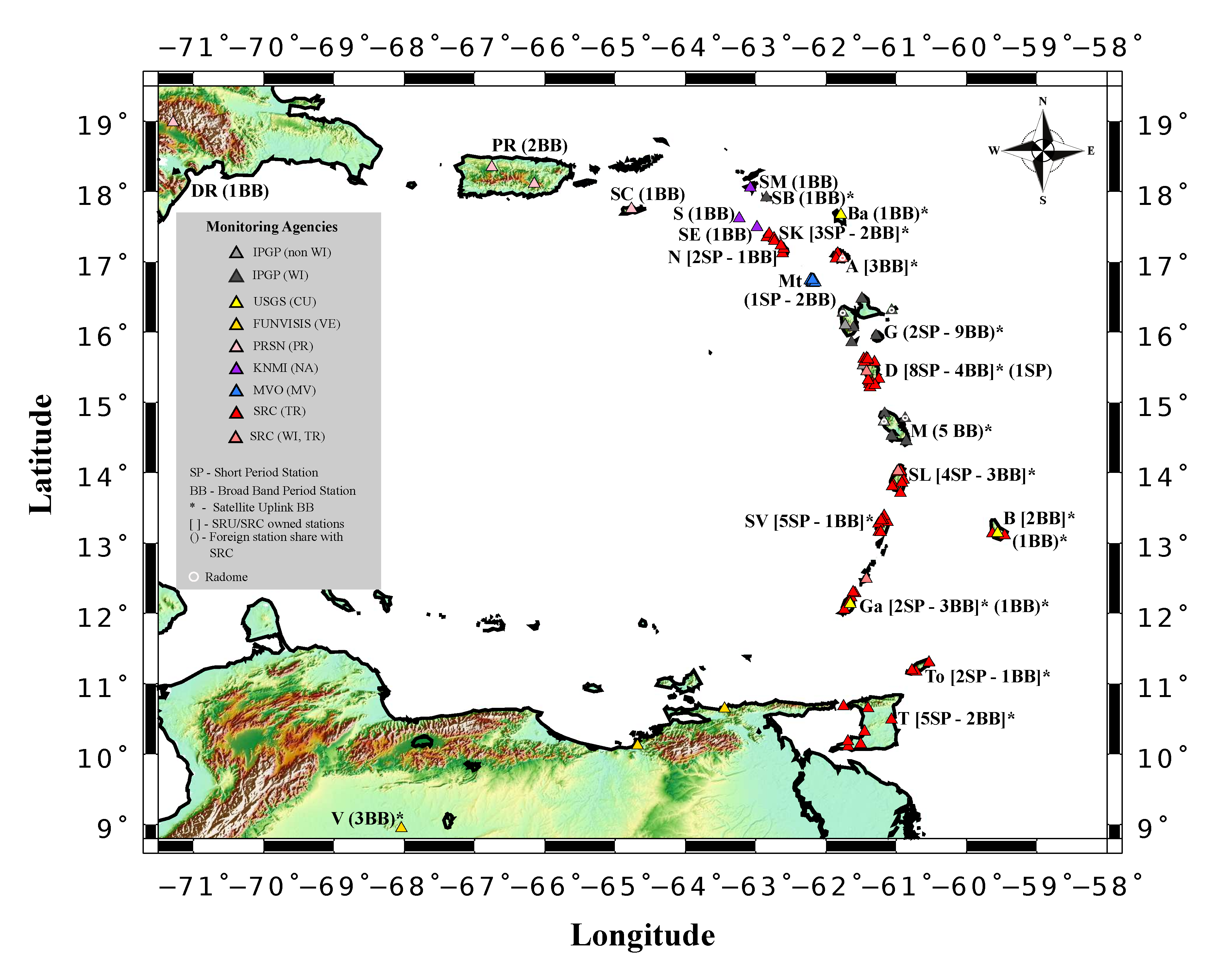
3.2. 2006-to Present: A Fully Digital Operating Seismic Network

From 2006–2007, the SRC started operating fully digital seismic stations (Class 5) in parallel with the hybrid network, which relies on the Soufrière system. This decision was made partly with the aim to meet technical requirements (i.e., digital broadband stations with real time transmission) for the development of an early tsunami warning and mitigation system for the Caribbean basin (ICG/CARIBE-EWS http://iocaribe.ioc-unesco.org/icgcaribeews; e.g., [18]) by the Intergovernmental Oceanographic Commission of the IOC-UNESCO in response to the disastrous tsunami triggered by the 26 December 2004 Sumatra submarine earthquake. In the wake of this disaster, United States Federal Government funded an extension of the Global Seismic Network (GSN https://www.iris.edu/hq/programs/gsn) with the addition of nine new Caribbean seismic stations, of which three where located in SRC’s area of responsability: Barbados-BBGH, Grenada-GRGR, Barbuda-ANWB (Figure 7). These stations are fully digital stations equipped with very broadband (T > 240 s) seismometers (STS-2), strong motion accelerometers, autonomous renewable power systems (i.e., photovoltaic panels) and satellite telemetry. The SRC initiative to establish the first tsunami monitoring stations was co-funded, in 2006, by USAID https://www.usaid.gov/and the government of the Republic of Trinidad and Tobago. Among the five sites selected, three of them (St Kitts—SKI; St Vincent—SVB; Moule-à-Chique, Saint Lucia—MCLT) are upgrades of existing installations, while the other two are new stations (Tobago—TOSP and in Dominica—DLPL). These fully digital stations are equipped with Guralp CMG-40T (33 s), accelerometers (Metrozet T1000), Nanometrics Libra 1 digitizers and satellite telemetry. These stations had to be installed quickly. This meant that compromises had to be made on the site locations. The United States Geological Survey (USGS https://www.usgs.gov/) McMillan vault design was selected [19]. By the end of 2007, most of the SRC seismic network was still chiefly comprised of short period single-component seismometers since only the remote telemetry nodes were furnished with triaxial broadband (Figure 7). In the ensuing year the Koninklijk Nederlands Meteorologisch Instituut (KNMI https://www.knmi.nl/home) seismic network also installed similar class of seismic monitoring instrument to complement the ICG/CARIBE-EWS (Figure 8).
Further improvement in the establishment of its fully digital seismic network was made by SRC, when it initiated a partnership with the two French West Indies observatories, in Guadeloupe and Martinique, operated by Institut de Physique du Globe de Paris (IPGP http://www.ipgp.fr). The installation of the West Indies (WI) network, which was done during the period 2008–2014 [20]. Anglade et al. [20] provides a comprehensive description of the WI network for that period with detailed descriptions of the French stations and their characteristics. Currently the WI network includes 15 stations: 11 stations owned and operated by IPGP (see Figure 1 in [20]) and 4 stations operated by the SRC (ANBD in Antigua, DSLB in Dominica, GCMP in Carriacou and SLBI in Saint Lucia; see Figure 9 and Figure 10). In addition to contributing to the ICG/CARIBE-EWS the WI network aims to provide high quality data to investigate subduction and volcanic processes occurring along the Lesser Antilles Arc [20]. Simultaneously, upgrade has been continuous on the KeJ sub-network as shown in Figure 9.
Figure 11 displays a typical design of an SRC fully digital seismic station with the Very Small Aperture Terminal (VSAT) satellite telemetry (Class 5). Such a set up is composed of two three-component instruments that are preferably a combination of a broadband seismometer with a strong motion accelerometer both time synchronized via an on-site GPS clock. All of the SRC’s VSAT station use a GPS clock to time stamp the data. The signal from each seismometer is digitized by a 3-channel 24-bit digitizer prior to real-time data streaming via the VSAT telemetry to SRC’s dedicated storage and processing servers at the SRC headquarters (VSAT hub). The real-time data are also shared via VSAT with the two other hubs of the WI network located at the Guadeloupe and Martinique observatories [20]. To increase the robustness of the network, especially against severe weather conditions, five stations (ANBD in Antigua, DSD in Desirade, DHS in northern Basse-Terre, and ILMA and FDF in Martinique) were equipped with radomes (for a VSAT station design with radomes, see Figure 2 in [20]).
Currently, the SRC operates 56 seismic stations (Figure 10). The majority of them stream their data to SRC’s headquarter via public Internet. Aside from access to the IPGP VSAT stations (11), the SRC seismic digital network also benefits from accessing data from KNMI broadband digital stations (3), USGS (3 along the arc), the Puerto-Rico Seismic Network (PRSN, 3 http://redsismica.uprm.edu) and the Fundación Venezolana de Investigaciones Sismológicas (FUNVISIS, 3 http://www.funvisis.gob.ve) (see Figure 11). There are still a few single component seismometers operating in parallel to the digital network such as those in St. Kitts and Nevis sub-network (Lynch pers. comm.) or at the GRSS station on the Sisters Islands (Figure 9) that have yet to be upgraded. Table 1 summarizes the technological and topological evolution of the SRC seismic network from 1953 to now.
Monitor i.e., the data acquisition module of the Soufrière System operates at the majority of the sub-network nodes to acquire data from the remaining single-component stations which are then streamed via Internet into the Open-source acquisition software Earthworm at SRC headquarters in Trinidad. Data from all digital stations also stream into Earthworm at SRC headquarters whether via VSAT or Internet. Once converted with Earthworm into SeisAn format the phases of the seismic waveforms are picked with the Open-source software SeisAn [21]. The picks/phases are then processed in WurstMachine (Soufrière System). WurstMachine is the preferred processing software at the SRC because it was customized to address the long, narrow geometry of the network not matched by other processing system [16]. SRC also operates a Seiscomp-based auto-solution system to alert SRC’s stakeholders such as national disaster offices, and the public.
The short-term response of SRC i.e., its capacity to deploy seismic stations during a volcanic unrest crisis or for aftershock studies, has improved with the upgrade from analogue portable seismic kits to digital seismometer kits (Lynch pers. comm.). Each kit is composed of a broadband force feedback instrument coupled with 24-bit digitizer and a GPS receiver for high-precision time stamping receiver. Besides being lightweight and waterproof, these kits do not need to be locked during transport, which gives them plug-in-and-go capability. The output communication system is over ethernet.

4. Complementary Monitoring Networks

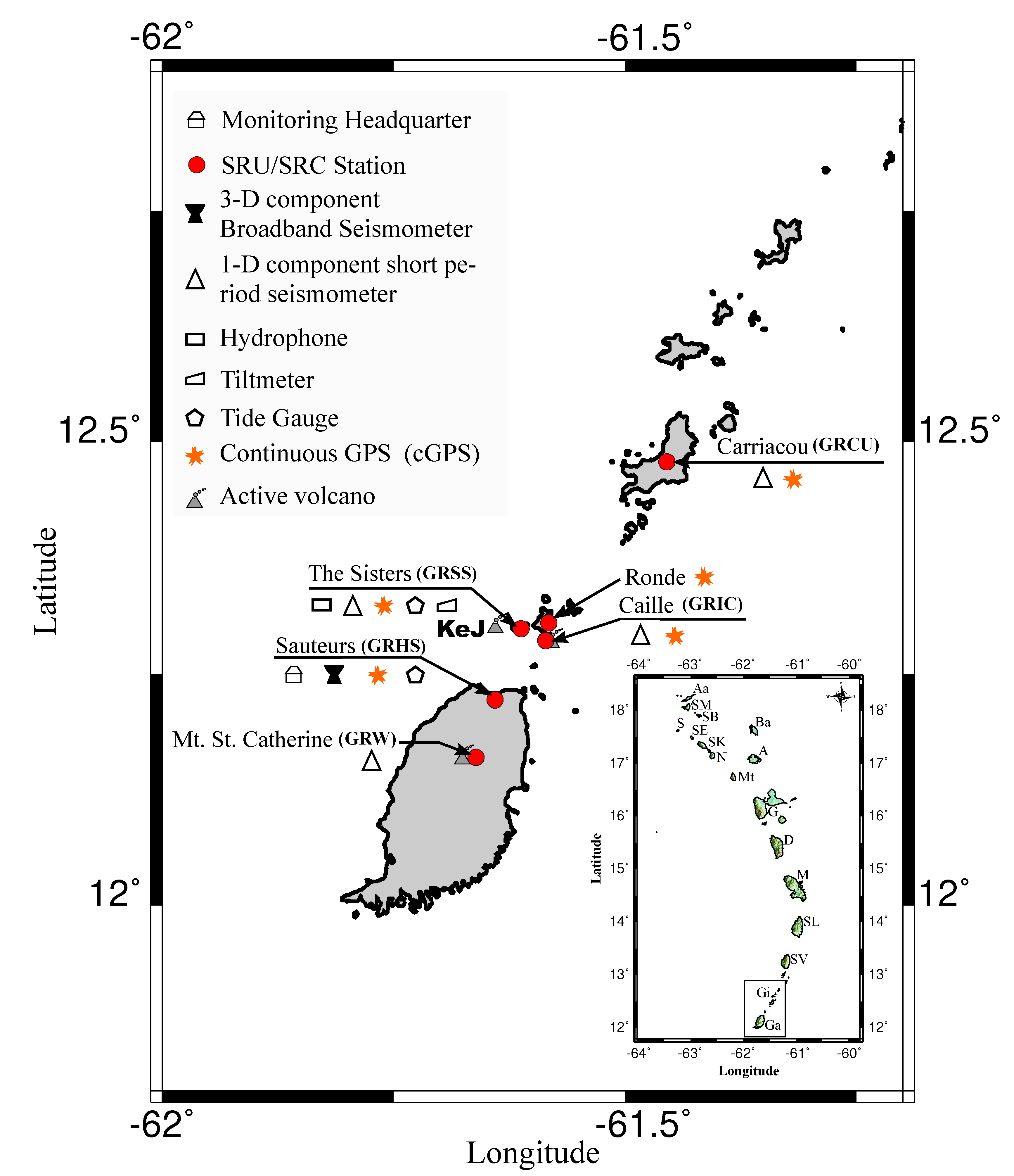
4.1. Ground Deformation Network

Ground deformation monitoring is an important component in the detection of volcanic unrest [22,23]. Very first ground deformation tests used a water-tube tiltmeter (“wet tilt“ method) that was installed in Montserrat in 1967 during the volcano-seismic unrest [4]. The water-tube tilt system was also tested in Nevis and St Vincent [4]. Several techniques for detecting ground deformation have been implemented or tested by SRC since the late 1970s. The dry-tilt monitoring technique was used at the Soufrière of St Vincent between 1977 and the early 2000s [3,24]. At total of 5 stations were installed on the volcano flank starting with 2 stations in 1977, then two additional stations in 1980 and one in 1983 [25]. The network revealed the gradual inflation of the volcano before the 1979 eruption followed by its rapid deflation during its eruption and most of the following year [26]. This network was eventually abandoned and entirely replaced by the GPS network installed on the island. In the case of KeJ an electronic bubble tiltmeter was installed and tested as part of the 2001 upgraded network on The Sisters Islands, the closest land to the vent. Ultimately, this technique had to be abandoned because of the difficulty and expense of accessing the site for maintenance.
Ground deformation monitoring using precision dual-frequency GPS has been part of the SRC monitoring network since the 2001. In the beginning (2001 up to 2007) GPS measurements were made by SRC scientists on Dominica, Grenada, Nevis, St Kitts, Saint Lucia, St Vincent. These measurements were made during short occupation campaigns using tripod setups and a network of benchmarks (stations) on each island on which measurements were made. Some of the benchmarks were installed by SRC these benchmarks supplemented the already existing benchmark points of the National Geodetic Survey of the National Oceanic and Atmospheric Administration (NGS-NOAA, USA), the UNAVCO https://www.unavco.org/ (USA), the Caribbean Planning for Adaptation to Global Climate Change (CPACC https://caricom.org/projects/detail/caribbean-planning-for-adaptation-to-climate-change-cpacc-project) and the national Land Survey agencies (e.g., Dominica, St Vincent). From 2007 SRC started to operate permanent continuous telemetered GPS (cGPS) installations equipped with Trimble NETRS, NETR8 and NETR9 receivers and Trimble Zephyr geodetic antennas (no radome). These instruments transmitted data via the Internet. A significant boost to the cGPS infrastructure came from the Continuously Operating Caribbean GPS Observational Network of UNAVCO (COCONet https://coconet.unavco.org/). COCOnet was initiated in 2010 with funding from the National Sciences Foundation (NSF) and University Corporation for Atmospheric Research (UCAR https://www.ucar.edu/). The project was designed to bolster the multi-hazards (Tectonics, Meteorological, Volcanic) research and early warning system capabilities in the Caribbean Basin region [27].
The SRC currently operates 11 cGPS stations which generally collect data at a 30 s observation rate. This rate allows for daily high precision (<1 ± cm) point estimates while limiting the size of the data files (ca. 1 MB per station per day) and reducing data storage needs. However, many of the instruments also record separate sessions at higher data rates of up to 10 Hz. This data is not stored routinely but can be downloaded if there is an event of interest with the high rates of ground motion, such as an earthquake. Figure 12 displays the SRC’s 11 cGPS stations. Among them eight are located on the volcanic islands of St Kitts (STKN), Nevis (BATH), Dominica (DOMP, DOMR, DOMI) (The stations on Dominica have been put out of commission by Hurricane Maria in 2017), Saint Lucia (CN04), St Vincent and The Grenadines (SVGB, SVGK), Grenada (GRE0). In addition to its own cGPS stations there are several other cGPS sites in the region. Besides two other UNAVCO operated stations, (DOMI in Dominica and CN04 in Saint Lucia) (members of the COCOnet) there are three UNAVCO-owned cGPS instruments installed at the respective SRC-operated VSAT seismic stations: GRMP-Carriacou, DSLB-Dominica, and ANBD-Antigua these are stations CN46, CN48 and CN01, respectively; and the French West Indies network (OVSG and OVSM) operate eleven cGPS stations (Figure 12). Data recorded are transmitted via Internet using File Transfer Protocol (FTP) for the cGPS of the SRC-owned cGPS and via VSAT for the UNAVCO-owned cGPS via the SRC and on to the UNAVCO server via ftp where they are available for public access. Various regional survey organization such as the Survey and mapping division in Trinidad and the Survey and mapping Section in Saint Lucia are potential sources of regional geodetic data. The cGPS data of the french observatories are accessible via an online catalogue (http://volobsis.ipgp.fr/index.php?page=gps).
Two projects: one in partnership with GNS of New Zealand and an associated project with JAXA (the Japanese space agency) have been initiated to investigate the effectiveness of Interferometric Synthetic Aperture Radar (InSAR) for monitoring the 13 Lesser Antilles Arc active volcanoes which are within the SRCs region of responsibility. If this technique proves useful in the densely vegetated Caribbean islands deformation data from the InSAR technique will provide complementary information to the cGPS monitoring network. InSAR has the potential to give deformation information over a wide geographical area with repeat time scales of approximately 12 days. The cGPS network only gives information on a few points per island. More extensive coverage requires very expensive campaigns which require occupation times of several days to obtain high-precision measurements. Due to their expense, time and human resource requirements such surveys can only be done every few years. Successful use of the InSAR technique would therefore be of great benefit to regional ground deformation monitoring. It is hoped that the high precision three-dimensional GPS-derived deformation vectors could be used as ground control to help interpret measurements derived from InSAR. Preliminary trials using SAR data for Montserrat from the ALOS-2 satellite [28] have been promising. Interferograms produced from SAR images covering Montserrat were up to approximately 50% coherent over the surface of the island. Multiple interferograms were stacked to average out the effects of atmospheric noise. In future work we may also use the GNSS data from the cGPS network to obtain atmospheric water vapour corrections to directly correct the interferograms [29].

4.2. Geochemistry Monitoring of Geothermal Systems

Geochemical monitoring has been carried out by SRC scientists since the early years of operation. Robson et al. [30] studied the total heat output of geothermal sites at Qualibou Soufrière of Saint Lucia, of several Soufrières on Dominica, of Galways and Gages Upper Soufrière on Montserrat, of the crater lake of St Vincent, and of Mount Misery in St Kitts. This work was the first comprehensive investigation of geothermal activity at volcanic systems in the LAA. Since then geochemical monitoring in the islands of the English-speaking Lesser Antilles has been more sporadic with sampling being conducted mostly during times of heightened seismic and/or volcanic activity. Joseph et al. [31] provides a review of these studies.
In 2000, as part of its volcano monitoring programme, SRC began routine geothermal monitoring of hydrothermal fluids at several volcanic islands in the Lesser Antilles. This monitoring programme involved the sampling of gas and thermal waters in Dominica [32,33], Grenada [34,35], Nevis [36]; St Kitts [36,37], Saint Lucia [38]; and St Vincent [34,39]. Particular focus has been placed on obtaining baseline geochemical data for geothermal systems in Dominica and Saint Lucia (Figure 13). Dominica was selected because of the high concentration of potentially active volcanoes in the vicinity of Roseau city, the main economic center; and Saint Lucia due to the high level of tourism at the Sulphur Spring Park located within the Soufrière Volcanic Centre. Both gas and water sampling programs and methods of analysis are described in detail by [40,41] in the case of Dominica and Saint Lucia, respectively.
In Dominica and Saint Lucia stable isotope data reveal that meteoritic water feeds the hydrothermal aquifers whose measured surface chemical compositions are buffered as a result. This buffering action reduces the ability to detect the magmatic component of the hydrothermal fluids [40]. The hydrothermal waters of both islands are predominantly acid-sulphate in compositions produced by the mixing between shallow groundwaters heated by rich sulphur bearing gases coming from depth. Hydrothermal gases generally have N 2 / A r ratios typical of arc-type gases. Despite the limitations resulting from the buffering action of the hydrothermal aquifers on the magmatic component of the thermal discharges, the continuous chemical monitoring of the geothermal systems in the Lesser Antilles has served to establish a database of the geochemical characteristics of these systems during periods of quiescence. These data provide a baseline for future volcanic monitoring. More recently, the geochemical monitoring network has been expanded to investigate the effects of volcanogenic air pollution and its possible effects on human health [42]

4.3. Ocean Bottom Mapping for Volcano Monitoring Purpose

The access to high resolution multibeam sonar imagery and constant improvement of the available technology on dedicated research and/or exploration vessels has greatly benefited volcanologists and aided in the study of submarine seamount activity (e.g., [43,44,45,46]).
Over the last 32 years because of KeJ’s underwater location SRC’s volcanologists have had to rely extensively on swath bathymetry to help them monitor the morphological evolution of the volcano [46]. The first multibeam survey of the volcano occurred during the 1985 R/V Robert D. Conrad survey [47]. The low resolution (19 beams per ping) of the echosounder yielded only a low-resolution view of the edifice. Similarly, the 1996 NOAA survey (R/V Malcom Baldrige) did not provide a significant improvement in the resolution of the image of the edifice and its surroundings (see [48]). In 2002, NOAA’s Ronald H. Brown cruise produced the very first detailed image of the upper sector of the edifice [6] thanks to an echosounder (SeaBeam 2112-12 kHz) capable of producing 120 beams per ping. In March 2003 the entire edifice was surveyed again [6,49] by the R/V Ronald H. Brown using the same instrument and at the same level of resolution as the 2002 survey. Images from this survey revealed a past landslide deposit area associated with at least one past sector collapse episodes that affected a previous proto-edifice [45,49]. Among the three sector collapse episodes identified by [45] the second episode was dated to have occurred at least 43.5 kyr B.P. (using radiocarbon dating; [50]). Between 2013 and 2017 four surveys were carried at the volcano: the 2013 NA039 survey and the 2014 NA054 survey aboard E/V Nautilus; the 2016 and 2017 aboard the R.R.S. James Cook. To this date the 2013 NA039 survey has produced the most detailed image of KeJ and its surroundings due to a 30 kHz Kongsberg EM302 echosounder with 432 beams per ping. During the same cruise a combination of mapping sensors installed on remotely operated vehicle Hercules were also used: a 1375 kHz BlueView Technologies multibeam instrument performing simultaneously with stereo cameras and a structure light laser system [51]. These sensors enable the production of a very high resolution (cm-scale) mapping and photomosaiced image of the inner crater (see Figure 2 in [52]). Allen et al. [46] have provided the very first model of morphological evolution of edifice over the last 32 years (1985–2017) i.e., a period covering 5 seismic crises (1988, 1990, 2001, 2015 and 2017). The model was generated using the swath bathymetry datasets collected from six surveys (RV Robert D. Conrad (1985), RV Ronald H. Brown (2003), EV Nautilus (2013 and 2014) and R.R.S James Cook (2016 and 2017)). Morphological change identified at KeJ display phases of construction (dome growth) as well as phases of erosion that occurred over the last 32 years at the volcano in a similar fashion to other active seamount elsewhere in the world. Both constructive and erosive phases can be correlated with T-phase signals which have been recorded by the KeJ monitoring sub-network (Latchman in prep). The study also reports a phase of flank swelling between 2016–2017 as a result of an intrusion at shallow depth on the north-western flank.

5. Challenges and Solutions

A major challenge for SRC has been severe funding limitations, a reflection of the generally low GDP-per-capita of the islands of the Eastern Caribbean. The operation and maintenance of its monitoring network has been hindered by the inability of the territories its serves, which are responsible for funding its operation to provide consistent financial contributions to the SRC’s annual budget. Related to this are the logistical challenges of operating over a large geographical area that consists of separate, independent islands. The long repose periods between volcanic eruptions in the region may also be responsible for a degree of complacency which, in turn, may affect commitments to funding.
The expense of cGPS installations and the difficulty in maintaining them and maintaining communication across often poor Internet connections means that the number of cGPS installations across the islands is fairly sparse and while this network is quite useful in defining the motion of the Caribbean plate [53] it is insufficient for detailed monitoring of ground deformation that might be associated with deep magma movement and volcanic unrest. The lack of adequate financial support has limited the number of installed cGPS stations across and along the arc. This has constrained the resolution of this network to a level that limits the development of accurate ground deformation models for the active volcanoes monitored by SRC.
The impact of hydro-metereological hazards are another factor that poses challenges to the operation and maintenance of the SRC monitoring network. For example, although the intense hurricane season in 2017 did not cause much damage to the SRC’s seismic digital stations, they did have a strong impact on the monitoring activity due to their effects on local infrastructure which in turn affects the ability to visit station sites to undertake repairs.
Field-deployed scientific equipment in the Lesser Antilles are at risk of vandalism and there have been many occasions where remote sites have been vandalized. The potential cost of repairs to a VSAT station due to vandalism could be up to US$80,000 (Lynch pers. comm.).
The SRC has been continuously implementing new strategies to address the challenges it faces. With regards to the resource limitations and its effect on the monitoring networks (e.g., seismic network). SRC has been able over the last 20 years to counter its funding limitation coming from the Eastern Caribbean nation thanks to partnership with foreign monitoring agencies which have facilitated the access to new funding opportunities; COCONet (NSF grant) and TSUAREG (2011–2015 European Union commission grant) projects have contributed to the improvement of both the volcano and seismic monitoring network. Also since 2006 SRC has partnered with other regional networks to share data. As a consequence the effects of funding limitations has become less severe because the net cost of ownership/maintenance of multi-institutional virtual networks (CU (USGS), WI (IPGP), TR (SRC), NA (KNMI), etc.) is shared among participating subscribers and is therefore lower. About the lack of a dense permanent cGPS network a possible solution is to periodically undertake long-occupations of all GPS benchmarks around active volcanoes, using a denser, temporary, network of GPS receivers. For these field campaigns the SRC has purchased 10 Septentrio PolaRx5 GNSS receivers along with 10 Trimble Zephyr 3 Geodetic GNSS antennas. Another option that is also being explored is developing in-house capacity to access and use remote sensing techniques to measure ground deformation. The mitigation of vandalism of SRC’s equipment requires more pro-active policies from its main contributors. One solution is for contributors to provide improved security. Another is for both to enhance public awareness of the importance of these monitoring sites.

6. Conclusions

The SRC’s volcano monitoring network is an important asset of the Eastern Caribbean region. The monitoring network is vital in the effort to mitigate the effects of volcanological hazards and help strengthen regional resilience to these hazards. Since its early days in the 1950s the SRC volcano monitoring network has been in constant evolution to incorporate the latest standards and technology to fulfill its mandate. Throughout the years not only has the agency improved the main pillar of its monitoring network (i.e., the seismic network), but it has expanded monitoring to include other data streams based on other techniques. These improvements along with ongoing research have served to increase the level of understanding of the geological threat along the arc. However, several challenges remain, mainly related to financial sustainability and the ability of the SRC to continue to improve and expand its monitoring network. Continued improvement will depend on how successful it is in coping with these and other challenges.

Author Contributions

F.J.-Y.D. wrote the manuscript, and L.L., G.A.R., E.P.J., C.R., I.P., J.L.L., R.E.A.R. helped in the improvement the manuscript. All authors read and approved the final manuscript.

Funding

This research received no specific external funding but results from the routine operations of the Centre which is funded by nine contributing territories of the Eastern Caribbean (i.e., St. Kitts & Nevis, Antigua & Barbuda, Montserrat, Dominica, Saint Lucia, St. Vincent & the Grenadines, Barbados, Grenada, Trinidad & Tobago).

Acknowledgments

The authors would like to thank Prof. Nick Varley, guest-editor of this special publication “Volcano Monitoring—Placing the Finger on the Pulse” of the Geoscience Journal for the opportunity to address the case of the SRC’s volcano monitoring network. The authors would like to thank the reviewers for their fruitful reviews to help improve this article. All maps were produced using the Generic Mapping Tools (version 5.3.1; [54] as well as the 30 arc seconds GEBCO_2014 grid of the General Bathymetric Chart of the Oceans [55].

Conflicts of Interest

The authors declare no conflict of interest.

Abbreviations

The following abbreviations, acronyms are used in the text body.
ADSLAsymmetric Digital Subscriber Line
CPACCCaribbean Planning for Adaptation to Global Climate Change
COCONetContinuously Operating Caribbean GPS Observational Network of UNAVCO
CUCaribbean Network (USGS)
FDSNInternational Federation of Digital Seismograph Networks
FUNVISISFundación Venezolana de Investigaciones Sismológicas
cGPSContinuous Global Positioning System
GEBCOThe General Bathymetric Chart of the Oceans
GNSSGlobal Navigation Satellite System
GSNGlobal Seismic Network
InSARInterferometric Synthetic Aperture Radar
ICGIntergovernmental Coordination Group
IOC-UNESCOIntergovernmental Oceanographic Commission of UNESCO
IPGPInstitut de Physique du Globe de Paris
KeJKick-’em-Jenny Submarine Volcano
KNMIKoninklijk Nederlands Meteorologisch Instituut
MDPIMultidisciplinary Digital Publishing Institute
MVMontserrat Volcano Observatory
NACaribbean Netherlands Seismic Network
NOAANational Oceanic and Atmospheric Administration
NSFNational Science Foundation
PRSNPuerto-Rico Seismic Network
SRCSeismic Research Centre
SRUSeismic Research Unit
TRUWI-SRC Eastern Caribbean Network
UCARUniversity Corporation for Atmospheric Research
UHFUltra High Frequency
UNAVCOUniversity NAVSTAR Consortium (former name of the non-profit university governed consortium)
UNESCOThe United Nations Educational, Scientific and Cultural Organization
USAIDThe United States Agency for International Development
USGSThe United State Geological Survey
UWIThe University of the West Indies
VERed Sismologica Nacional con Apertura Continental
VSATVery Small Apperture Terminal
WIWest Indies Network (IPGP, UWI-SRC)

References

  1. Boudon, G.; Le Friant, A.; Villemant, B.; Viode, J.P. Martinique. In Volcanic Hazard Atlas of the Lesser Antilles; Lindsay, J.M., Robertson, R.E.A., Shepherd, J.B., Ali, S., Eds.; Seismic Research Unit, The University of the West Indies: St. Augustine, Trinidad and Tobago, 2005; pp. 128–146. [Google Scholar]
  2. Lacroix, A. La Montagne Pelée et ses Eruptions; Masson: Paris, France, 1904; pp. 1–662. [Google Scholar]
  3. Lynch, L.; Ambeh, W.; Robertson, R.; Latchman, J.; Bridgemohan, M. A medium-sized seismograph network in a challenging environment. Geofís. Int. 1996, 35, 213–226. [Google Scholar]
  4. Latchman, J.; Lynch, L.; Edwards, S. 60 years of monitoring volcanic and earthquake activity in the English-speaking Eastern Caribbean. Caribb. Geogr. 2012, 17, 3–17. [Google Scholar]
  5. Latchman, J. Seismic Potential of the S.W. Tobago Fault System. Master’s Thesis, The University of the West Indies, St. Augustine, Trinidad and Tobago, 1998. [Google Scholar]
  6. Lindsay, J.M.; Shepherd, J.B.; Wilson, D. Volcanic and scientific activity at Kick’em Jenny submarine volcano 2001–2002: Implications for volcanic hazards in the Southern Grenadines, Lesser Antilles. Nat. Hazards 2005, 34, 1–24. [Google Scholar] [CrossRef]
  7. Lindsay, J.M.; Robertson, R.E.A.; Shepherd, J.B.; Ali, S. (Eds.) Volcanic Atlas of the Lesser Antilles; Seismic Research Unit, The University of the West Indies: St. Augustine, Trinidad and Tobago, 2005; pp. 1–279. [Google Scholar]
  8. DeMets, C.; Jansma, P.E.; Mattioli, G.S.; Dixon, T.H.; Farina, F.; Bilham, R.; Calais, E.; Mann, P. GPS geodetic constraints on Caribbean-North America plate motion. Geophys. Res. Lett. 2000, 27, 437–440. [Google Scholar] [CrossRef]
  9. Speed, R.; Smith-Horowitz, P.; Perch-Nielsen, K.; Saunders, J.; Sanfilippo, A. Southern Lesser Antilles arc platform: Pre-Late Miocene stratigraphy, structure, and tectonic evolution. Geol. Soc. Am. Spec. Pap. 1993, 277, 98. [Google Scholar]
  10. Weber, J.; Dion, T.H.; DeMets, C.; Ambeh, W.B.; Jansma, P.; Mattioli, G.; Saleh, J.; Sella, G.; Bilham, R.; Perez, O. GPS estimate of relative motion between the Caribbean and the South American plates, and geologic implication for Trinidad and Venezuela. Geology 2001, 29, 75–78. [Google Scholar] [CrossRef]
  11. Feuillet, N.; Beauducel, F.; Tapponnier, P. Tectonic context of moderate to large historical earthquakes in the Lesser Antilles and mechanical coupling with volcanoes. J. Geophys. Res. 2011, 116, 1–26. [Google Scholar] [CrossRef]
  12. Wadge, G.; Shepherd, J.B. Segmentation of the Lesser Antilles subduction zone. Earth Planet. Sci. Lett. 1984, 71, 297–304. [Google Scholar] [CrossRef]
  13. Wadge, G. The dykes and structural setting of the volcanic front in the Lesser Antilles island arc. Bull. Volcanol. 1986, 48, 349–372. [Google Scholar] [CrossRef]
  14. Sykes, L.R.; McCann, W.R.; Kafka, A.L. Motion of the Caribbean plate during the last 7 millions years and implications for earlier Cenozoic movements. J. Geeophys. Res. 1982, 87, 10656–10676. [Google Scholar] [CrossRef]
  15. Bouysse, P.; Westercamp, D. Subduction of Atlantic aseismic ridges and Late Cenozoic evolution of the Lesser Antilles island arc. Tectonophysics 1990, 175, 349–380. [Google Scholar] [CrossRef]
  16. Beckles, D.; Shepherd, J.; Aspinall, W. The Wurst machine: A programme for estimating hypocentral coordinates of regional earthquakes. In Proceedings of the First Meeting of the Asociacion Ibero-Latino Americana de Geofisica; Asociacion Ibero-Latino Americana de Geofisica: Caracas, Venezuela, 1977; pp. 95–125. [Google Scholar]
  17. Beckles, D.; Shepherd, J.; Aspinall, W. The “Soufrière” system: PC-based instrumentation for acquiring and processing data from seismograph networks (ext. Abs). Tectonophysics 1992, 209, 47–49. [Google Scholar] [CrossRef]
  18. The Intergovernmental Oceanographic Commission of UNESCO. One Planet. One Ocean; IOC Brochure 2017-1; IOC: Paris, France, 2017; 68p.
  19. McMillan, J.R. Methods of Installing United States National Seismographic Network (USNSN) Stations—A Construction Manual; USGS Open-File Report; USGS: Reston, VA, USA, 2002.
  20. Anglade, A.; Lemarchand, A.; Saurel, J.M.; Clouard, V.; Bouin, M.P.; De Chabalier, J.B.; Tait, S.; Brunet, C.; Nercessian, A.; Beauducel, F.; et al. Significant technical advances in broadband seismic stations in the Lesser Antilles. Adv. Geosci. 2015, 40, 43–50. [Google Scholar] [CrossRef] [Green Version]
  21. Havskov, J.; Ottemoller, L. SeisAn earthquake analysis software. Seismol. Res. Lett. 1999, 70, 532–534. [Google Scholar] [CrossRef]
  22. Mogi, K. Relations between the eruptions of various volcanoes and the deformations of the ground surface around them. Bul. Earthq. Res. Inst. 1958, 36, 99–134. [Google Scholar]
  23. Dzurizin, D. Volcano Deformation; Springer: Berlin, Germany, 2007. [Google Scholar] [CrossRef]
  24. David, J. Internal Report about the Ground Deformation campaign in St Vincent 5–27 September 2001; Internal Report; Seismic Research Unit, The University of the West Indies: St. Augustine, Trinidad and Tobago, 2001. [Google Scholar]
  25. Fiske, R.S.; Shepherd, J. Twelve years of ground-tilt measurements on the Soufriere of St. Vincent, 1977–1989. Bull. Volcanol. 1990, 52, 227. [Google Scholar] [CrossRef]
  26. Fiske, R.S.; Shepherd, J. Deformation Studies on Soufriere, St. Vincent, Between 1977 and 1981. Science 1982, 216, 1125–1126. [Google Scholar] [CrossRef] [PubMed]
  27. Braun, J.; Mattioli, G.S.; Calais, E.; Carlson, D.; Dixon, T.H.; Jackson, M.E.; Kursinski, E.R.; Mora-Paez, H.; Miller, M.M.; Pandya, R.; et al. Focused study of interweaving hazards across the Caribbean. EOS Trans. AGU 2012, 93, 89. [Google Scholar] [CrossRef]
  28. Ryan, G.; Hamling, I.J.; Pascal, K. Measuring Volcano Related Ground Deformation in the Eastern Caribbean; Interim Report ra6 (for Japan Aerospace Exploration Agency); The University of the West Indies, Seismic Research Center: St. Augustine, Trinidad and Tobago, 2018; p. 16. [Google Scholar]
  29. Yu, C.; Li, Z.; Penna, N. Interferometric synthetic aperture radar atmospheric correction using a gps-based iterative tropospheric decomposition model. Remote Sens. Environ. 2018, 204, 109–121. [Google Scholar] [CrossRef]
  30. Robson, G.; Willmore, P. Some heat measurements in West Indian soufrieres. Bull. Volcanol. 1955, 17, 13. [Google Scholar] [CrossRef]
  31. Joseph-Ramdan, E. Geochemistry of Geothermal Systems in St Lucia and Dominica, Lesser Antilles: Implications for Volcanic Monitoring. Ph.D Thesis, The University of the West Indies, St. Augustine, Trinidad and Tobago, 2008; 240p. [Google Scholar]
  32. Joseph, E.; Robertson, R. Sampling of Geothermal Features in St. Lucia and Dominica 3–9 November 2003; Internal Report; Seismic Research Unit, The University of the West Indies: St. Augustine, Trinidad and Tobago, 2003. [Google Scholar]
  33. Lindsay, J.; Smith, A.; Roobol, M.; Stasiuk, M. Dominica. In Volcanic Hazard Atlas of the Lesser Antilles; Lindsay, J.M., Robertson, R.E.A., Shepherd, J.B., Ali, S., Eds.; Seismic Research Unit, The University of the West Indies: St. Augustine, Trinidad and Tobago, 2005; pp. 2–47. [Google Scholar]
  34. Joseph, E. Sampling of Geothermal Features in Grenada and St. Vincent 18–21 June 2003; Internal Report; Seismic Research Unit, The University of the West Indies: St. Augustine, Trinidad and Tobago, 2003. [Google Scholar]
  35. Robertson, R. Grenada. In Volcanic Hazard Atlas of the Lesser Antilles; Lindsay, J.M., Robertson, R.E.A., Shepherd, J.B., Ali, S., Eds.; Seismic Research Unit, The University of the West Indies: St. Augustine, Trinidad and Tobago, 2005; pp. 49–66. [Google Scholar]
  36. Lindsay, J. Report on Visit to Sample Features in Geothermal Areas of St. Kitts and Nevis, 18–22 April 2001; Internal Report; Seismic Research Unit, The University of the West Indies: St. Augustine, Trinidad and Tobago, 2003. [Google Scholar]
  37. Robertson, R. St. Kitts. In Volcanic Hazard Atlas of the Lesser Antilles; Lindsay, J.M., Robertson, R.E.A., Shepherd, J.B., Ali, S., Eds.; Seismic Research Unit, The University of the West Indies: St. Augustine, Trinidad and Tobago, 2005; pp. 202–217. [Google Scholar]
  38. Lindsay, J. St. Lucia. In Volcanic Hazard Atlas of the Lesser Antilles; Lindsay, J.M., Robertson, R.E.A., Shepherd, J.B., Ali, S., Eds.; Seismic Research Unit, The University of the West Indies: St. Augustine, Trinidad and Tobago, 2005; pp. 218–238. [Google Scholar]
  39. Robertson, R. St. Vincent. In Volcanic Hazard Atlas of the Lesser Antilles; Lindsay, J.M., Robertson, R.E.A., Shepherd, J.B., Ali, S., Eds.; Seismic Research Unit, The University of the West Indies: St. Augustine, Trinidad and Tobago, 2005; pp. 240–261. [Google Scholar]
  40. Joseph, E.; Fournier, N.; Lindsay, J.; Fischer, T. Gas and water geochemistry of geothermal systems in Dominica, Lesser Antilles island arc. J. Volcanol. Geother. Res. 2011, 206, 1–14. [Google Scholar] [CrossRef]
  41. Joseph, E.; Fournier, N.; Lindsay, J.; Robertson, R.; Beckles, D. Chemical and isotopic characteristics of geothermal fluids from Sulphur Springs, Saint Lucia. J. Volcanol. Geother. Res. 2013, 254, 23–36. [Google Scholar] [CrossRef]
  42. Joseph, E.; Beckles, D.; Cox, L.; Jackson, V.; Alexander, D. An evaluation of ambient sulphur dioxide concentrations from passive degassing of the Sulphur Springs, Saint Lucia geothermal system: Implications for human health. J. Volcanol. Geother. Res. 2015, 304, 38–48. [Google Scholar] [CrossRef]
  43. Clouard, V.; Bonneville, A. Submarine Landslides in French Polynesia. In Oceanic Hotspots: Intraplate Submarine Magmatism and Tectonism; Hekinian, R., Cheminée, J.L., Stoffers, P., Eds.; Springer: Berlin/Heidelberg, Germany, 2004; pp. 209–238. [Google Scholar] [CrossRef]
  44. Chadwick, W.W., Jr.; Wright, I.C.; Schwarz-Schampera, U.; Hyvernaud, O.; Reymond, D.; de Ronde, C.E.J. Cyclic eruptions and sector collapses at Monowai submarine volcano, Kermadec arc: 1998–2007. Geochem. Geophys. Geosyst. 2008, 9, Q10014. [Google Scholar] [CrossRef]
  45. Dondin, F.; Lebrun, J.F.; Kelfoun, K.; Fournier, N.; Randrianasolo, A. Sector collapse at Kick ’em Jenny submarine volcano (Lesser Antilles)—Numerical simulation and mass flow behaviour implications. Bull. Volcanol. 2012, 74, 595–607. [Google Scholar] [CrossRef]
  46. Allen, R.; Berry, C.; Henstock, T.; Collier, J.; Dondin, F.Y.; Rietbrock, A.; Latchman, J.; Robertson, R. 30 Years in the Life of an Active Submarine Volcano: A Time-Lapse Bathymetry Study of the Kick-‘em-Jenny Volcano, Lesser Antilles. Geochem. Geophys. Geosyst. 2018. [Google Scholar] [CrossRef]
  47. Bouysse, P.; Mascle, A.; Mauffret, A.; Mercier de Lepinay, B.; Jany, I.; Leclerc-Vanhoeve, A.; Montjarret, M.C. Reconnaissance de structures tectoniques et volcaniques sous-marines de l’arce recent des Petites Antilles (Kick ’em Jenny, Qualibou, Montagne Pelée, Nord-Ouest de la Guadeloupe). Mar. Geol. 1988, 81, 261–287. [Google Scholar] [CrossRef]
  48. Watlington, R.; Wilson, W.; Johns, W.; Nelson, C. Updated bathymetric survey of Kick-’em-Jenny submarine volcano. Mar. Geophys. Res. 2002. [Google Scholar] [CrossRef]
  49. Lindsay, J.M.; Shepherd, J.B. Kick ’em Jenny and Île de Caille. In Volcanic Hazard Atlas of the Lesser Antilles; Lindsay, J.M., Robertson, R.E.A., Shepherd, J.B., Ali, S., Eds.; Seismic Research Unit, The University of the West Indies: St. Augustine, Trinidad and Tobago, 2005; pp. 105–125. [Google Scholar]
  50. Dondin, F.Y.; Heap, M.; Robertson, R.; Dorville, J.F.; Carey, S. Flank instability assessment at Kick-’em-Jenny submarine volcano (Grenada, Lesser Antilles): A multidisciplinary approach using experiments and modeling. Bull. Volcanol. 2017, 79, 5. [Google Scholar] [CrossRef]
  51. Roman, C.; Inglis, G.; Vaughn, I.; Smart, C.; Dansereau, D.; Bongiorno, D.; Johnson-Roberson, M.; Bryson, M. New tools and methods for precision seafloor mapping. Oceanography 2013, 26, 10–15. [Google Scholar]
  52. Carey, S.; Olsen, R.; Bell, K.; Ballard, R.; Dondin, F.; Roman, C.; Smart, C.; Lilley, M.; Lupton, J.; Seibel, B.; et al. Hydrothermal venting and mineralization in the crater of Kick’em Jenny submarine volcano, Grenada (Lesser Antilles). Geochemistry 2016. [Google Scholar] [CrossRef]
  53. Symithe, S.; Calais, E.; Chabalier, J.B.; Robertson, R.; Higgins, M. Current block motions and strain accumulation on active faults in the Caribbean. J. Geophys. Res. Solid Earth 2015, 120, 3748–3774. [Google Scholar] [CrossRef] [Green Version]
  54. Wessel, P.; Smith, W.H.F.; Scharroo, R.; Luis, J.; Wobbe, F. Generic Mapping Tools: Improved Version Released. Eos Trans. Am. Geophys. Union 2013, 94, 409–410. [Google Scholar] [CrossRef] [Green Version]
  55. The GEBCO_2014 Grid, Version 20150318. 2014. Available online: www.gebco.net (accessed on 15 October 2015).
Figure 1. Map showing of the 21 live volcanoes identified along the Lesser Antilles volcanic arc, generated after [7]. Light red dashed-line highlight the active volcanic front. A: Antigua; Aa: Anguilla; Ba: Barbuda; Ca: Carriacou; D: Dominica; G: Guadeloupe archipelago; Ga: Grenada; M: Martinique; Mt: Montserrat; N: Nevis; S: Saba; SB: St Bart; SE: St Eustatius; SK: St Kitts; SL: Saint Lucia; SM: St Marteen; SV: St Vincent. Black parallel lines represent the volcanic segments (see in text); 1: northern segment; 2: middle segment; 3: southern segment. Dark gray parallel lines represent the volcanic segments; 1: northern segment; 2: middle segment; 3: southern segment (see details in text).
Geosciences 09 00071 g001
Figure 2. The 1971 analogue micro-earthquake network (Class 2 network) equipped with analogue Willmore photographic seismograph. (Figure adapted after Lynch pers. comm.)
Geosciences 09 00071 g002
Figure 3. Flow chart of the UWI-SRC seismic data processing system performed with the WurstMachine [16].
Geosciences 09 00071 g003
Figure 4. The 1982 Class 3 hybrid network: analogue station with analogue transmission associated with digital recording and data processing. (Figure adapted after Lynch pers. comm.)
Geosciences 09 00071 g004
Figure 5. The 1998 SRU’s hybrid network including newly installed Class 4 stations. 3cS: Three-component seismometer; ADC: Analog to digital converter; ADT: Analog data transmission; ASR: Analog signal reception; DR & DP: Digital recording and digital processing; RFS: Remote field station; ST: Synchronized time; TT: Trinidad and Tobago. Figure adapted after Lynch pers. comm.
Geosciences 09 00071 g005
Figure 6. Map of the Grenada monitoring network as it was in early 2004 displaying the location of the stations GRW at Mt St. Catherine, GRHS at Sauteurs, GRIC at Isle de Caille, GRSS at the Sisters Islands, and GRCU at Carriacou. Inset: Antigua (A); Anguilla (Aa); Barbuda (Ba); Carriacou (Ca); Dominica (D); Guadeloupe archipelago (G); Grenada (Ga); Martinique (M); Montserrat (Mt); Nevis (N); Saba (S); St Bart (SB); St Eustatius (SE); St Kitts (SK); Saint Lucia (SL); St Marteen (SM); St Vincent (SV). Map is adapted from Figure 1 in [6]. KeJ: Kick-’em-Jenny submarine volcano.
Geosciences 09 00071 g006
Figure 7. (Left) The 2005 Seismic Research Unit (SRU) sub-network nodes and their location in the Eastern Caribbean; (Right) Sub-network nodes (pink rounded rectangles) as part of the hybrid SRU’s seismic network. 3DSP: 3-component short period instrument; 3DLP: 3-component long period instrument; BB: Broadband instrument; Light green color refers to a foreign short period instrument shared with SRC’s network.
Geosciences 09 00071 g007
Figure 8. Architecture of the SRC seismic network by 2011. Asterix refers to the replacement of old single-component short period analogue instruments by three-component seismometers (short period, SP, or broadband, BB) at the following stations: MBGH, MBFL, MDPV, MDMP, MDCT, MDPO MDVC, DWS, SSVW, SVCV. FUNVISIS: Fundación Venezolana de Investigaciones Sismológicas; GSN-CU: Global Seismic Network; IPGP: Institut de Physique du Globe de Paris; KNMI: Koninklijk Nederlands Meteorologisch Instituut; PRSN: Puerto-Rico Seismic Network; USGS: United State Geological Survey.
Geosciences 09 00071 g008
Figure 9. Map of an upgraded Grenada monitoring network with the addition of GRFF station at St Georges, the US Geological Survey (USGS)-owned GRGR station and a re-located Carriacou station (GCMP) in the year 2017. Inset: Antigua (A); Anguilla (Aa); Barbuda (Ba); Carriacou (Ca); Dominica (D); Guadeloupe archipelago (G); Grenada (Ga); Martinique (M); Montserrat (Mt); Nevis (N); Saba (S); St Bart (SB); St Eustatius (SE); St Kitts (SK); Saint Lucia (SL); St Marteen (SM); St Vincent (SV).
Geosciences 09 00071 g009
Figure 10. 2018 map of the location of the SRC seismic stations and the shared seismic stations from other regional monitoring agencies that are used by the SRC to monitor volcanic and earthquake hazards for the English-speaking Eastern Caribbean islands. Monitoring agencies: Fundación Venezolana de Investigaciones Sismológicas (FUNVISIS); Institut de Physique du Globe de Paris (IPGP); Koninklijk Nederlands Meteorologisch Instituut (KNMI); Puerto-Rico Seismic Network (PRSN); United State Geological Survey (USGS). Network code: Caribbean Network (CU); Montserrat Volcano Observatory (MV); Caribbean Netherlands Seismic Network (NA); Puerto-Rico Seismic Network (PR); UWI-SRC Eastern Caribbean Seismograph Network (TR); Red Sismologica Nacional con Apertura Continental (VE); West Indies Network (WI). A: Antigua; B: Barbados; Ba: Barbuda; D: Dominica; DR: Dominican Republic; G: Guadeloupe archipelago; Ga: Grenada; M: Martinique; Mt: Montserrat; N: Nevis; PR: Puerto-Rico; S: Saba; SB: St Barth; SC: St Croix; SE: St Eustatius; SK: St Kitts; SL: Saint Lucia; SM: St Maarten; T: Trinidad; To: Tobago; V: Venezuela.
Geosciences 09 00071 g010
Figure 11. SRC digital network design from field station to hub (SRC headquarter in St Augustine, Trinidad).
Geosciences 09 00071 g011
Figure 12. Location of the 11 SRC owned cGPS stations at volcanic islands (D, G, Ga, M, N, SK, SL, SV) and non volcanic islands (To, Ca, A). Green star indicates French West Indies cGPS stations of the Guadeloupe volcano observatory and the Martinique volcano observatory, both operated by the IPGP. Yellow star indicates the location of a UNAVCO cGPS installed at an SRC-owned VSAT seismic station. Blue star indicates stations from SRC, IPGP and UNAVCO which contribute to UNAVCO’s Continuously Operating Caribbean GPS Observational Network (COCONet). A: Antigua; B: Barbados; Ba: Barbuda; Ca: Carriacou; D: Dominica; G: Guadeloupe archipelago; Ga: Grenada; M: Martinique; Mt: Montserrat; N: Nevis; S: Saba; SB: St Barth; SE: St Eustatius; SK: St Kitts; SL: Saint Lucia; SM: St Maarten; SV: St Vincent; T: Trinidad; To: Tobago; V: Venezuela.
Geosciences 09 00071 g012
Figure 13. (Left) Dominica geothermal sites monitored by SRC as of 2000. (Right) Geothermal sites monitored by SRC at Sulphur Spring Park in the Soufrière Volcanic Centre, Saint Lucia. MD: Morne aux Diables; WW/M: Wotten Waven/ Morne Micotrin; VD: Valley of Desolation; PPVC: Plat Pays Volcanic Complex; SSP: Sulphur Spring Park of the Soufrière Volcanic Complex. Map reproduced using site location retrieved after [32,33,40].
Geosciences 09 00071 g013
Table 1. Technological and topological evolution of the SRC seismic network from 1953 to now.
Period of Operation1953–19611961–19801980–19981998–Present2006–Present
TechnologyAnalogHybridDigital
TopologyClass 1Class 2Class 3Class 4Class 5

