Article

Monsoon-Induced Surge during High Tides at the Southeast Coast of Vietnam: A Numerical Modeling Study

1
Vietnam National Hydrometeorolocical Forecasting Center, No. 8 Phao Dai Lang, Dong Da, Hanoi, Vietnam
2
Division of Oceanography and Maritime Meteorology, Norwegian Meteorological Institute, Bergen, Norway
*
Author to whom correspondence should be addressed.
Geosciences 2019, 9(2), 72; https://doi.org/10.3390/geosciences9020072
Submission received: 26 September 2018 / Revised: 18 January 2019 / Accepted: 21 January 2019 / Published: 31 January 2019
(This article belongs to the Section Natural Hazards)

Abstract

:
In this study, monsoon-induced surge during high tides at the Southeast coast of Vietnam was analyzed based on the observed tide data at the Vung Tau station in the period between 1997—2016. Specifically, the surge was determined by removing the astronomical tide from the observed total water level. The two-dimensional Regional Ocean Model System (ROMS 2D) was applied to simulate the surge induced by monsoons during spring tide. The surge observations showed that the change of peak surge did not follow a clear trend, of either an increase or decrease, over time. A peak surge of over 40 cm appeared mainly in October and November, although the peak of the astronomical tide was higher in December. ROMS 2D was validated with the observational data, and the model could sufficiently reproduce the wind-induced surge during high tides. This study therefor ere commends for ROMS 2D to be used in operational forecasts in this area.

1. Introduction

Compared with other coastal areas in Vietnam, the Southeast coast is less affected by natural hazards coming from the sea such as storms and tropical low pressure systems. However, the region has certain geographical characteristics such as low plains and a large estuary system which make this area vulnerable to increased sea levels during spring tide (Tuan, 2000) [1]. This phenomenon has become more and more intense as the weather has become more variable in recent years; the maximum daily rainfall trend is increasing and the frequency of monsoons is rising on the South coast of Vietnam (e.g., Tan and Thanh, 2013) [2].
Seawater intrusion is dependent on the thetidal regime in coastal estuarine areas and the surge due to winds caused by tropical depressions and typhoons. The observed sea level (Hobserved) is the sum of astronomical tide (Htide) and surges (Hsurge) due to other factors, mainly typhoons, low pressure zones, or strong monsoons (Hobserved = Htide + Hsurge). In the coastal areas of the Southeast, the phenomenon of flooding during high tide (spring tide) occurs frequently from October to February; these are months with high tide amplitudes. In addition, these are the months when the activities of storms, tropical low pressure systems, and strong monsoon sareat the highest (Du et al., 2016) [3]. In recent years, the spring tides in Ho Chi Minh City have caused serious flooding in many parts of the city, affecting life and productivity. In November 2010, the high tide samplified, causing the entire 252 km east and west coastal line of Ca Mau province to be flooded up to 0.5m in depth for periods of about 2–3 h per day, as shown in Figure 1a (Minh and Lan, 2012) [4]. The spring tide in October 2013 caused a historic rise in water level at Vung Tau station (420 cm). Seawater intruded into Ho Chi Minh City, causing serious flooding for several days (Figure 1b) (Minh and Lan, 2012) [4].
In addition to the astronomical tide and the flooding caused by rain, it is possible that the flooding in Ho Chi Minh City had a significant contribution from the monsoon-induced surge. Consequently, there is significant motivation to study the monsoon-induced surge in combination with the spring tide in this area.
For several decades, climate change impact studies have focused on storm surge studies in Vietnam (e.g., Sao, 2008; Thang, 1999; Thuy, 2003; Chien et al., 2015; Thuy et al., 2014) [5,6,7,8,9]. Conventional two-or three-dimensional nonlinear shallow water equations have been used. However, the monsoon-induced surge has not been subject to much study, especially not in terms of numerical modeling. According to research by Ninh et al., in addition to typhoons, the monsoons also caused significant storm surges and, during strong monsoons (winds of force 6–7 on the Beaufort scale) with a duration of 2 to 3 days, significant surge heights of about 30–40 cm, sometimes higher, occurred [10]. Based on the analysis of water levels for many years at the tidal stations in Vietnam, Thanh [11] showed that in addition to astronomical tide fluctuations, there are fluctuations of sea levels in coastal areas and islands where the duration of the rise and fall is mainly influenced by the wind regime, especially in the Northeast monsoon season. The majority of the observed fluctuations have an amplitude of less than 50 cm; however, the magnitude of the rise due to monsoon winds can reach 30–40 cm (Thanh, 2011) [11]. When assessing the after-runner storm surge due to typhoon Kalmaegi (2014) which landed on coastal Hai Phong (Northern Vietnam), Thuy et al. [12] concluded that the strong Southwest monsoon is the main cause for this phenomenon. Analyzing two historic spring tide phases in Ho Chi Minh City in October 2010 and November 2011, Minh and Lan [4] concluded that the spring tide in Ho Chi Minh city was related to the strong Northeast monsoon. The main cause of the high sea levels, was due to high waves generated by strong winds that pushed water into the river mouths on the high tide days, resulting in an abnormal sea level rise.
In this study, the monsoon-induced surge in the spring tide phases at the Southeastern coast of Vietnam was analyzed based on water level observations at the Vung Tau station. Next, wind-induced surge in two spring tide phases was simulated by a numerical model. A harmonic analysis method was applied to remove the astronomical tide from the observed water level in order to determine the surge. The Regional Ocean Model System in 2D (ROMS 2D) was applied to simulate monsoon-induced surge on the coast in order to evaluate the model’s ability to forecast surges in the area.

2. Materials and Methods

2.1. Study Area and Data

In the study area, tidal cycles are semidiurnal, and tidal amplitudes tend to decrease from the northern coast of the Province of Binh Thuan to the southern coast of the Province of Ca Mau, as shown in Figure 2. The largest tidal amplitudes from Binh Thuan to Ca Mau are approximately 300–400 cm. There is only one tide station setup at Vung Tau. The location of the station is at longitude 107°04′ and latitude 10°20′ (Figure 2). The datum of tide observation is at the lowest tide in one tide circle (18.6 years).
To analyze the water level and surge height in the study area, the observed water levels at Vung Tau station over 30 years (1987–2016) were collected. To evaluate the capability of ROMS 2D to predict surges generated by monsoons, the wind and pressure re-analyses from the European Centre for Medium-Range Weather Forecasts (ECMWF) were used as inputs for the monsoon-induced surge prediction model.

2.2. Research Method

2.2.1. Harmonic Analysis of Astronomical Tide

The surge height was determined by subtracting the astronomical tide from the observed water level (total water level) according to the following formula:
Hsurge = Hobservation − Htide
where Hsurge is the surge height, Hobservation is the total water level height, and Htide is the astronomical tide height.
The harmonic analysis method was used to estimate the astronomical tide. In this method, the tide height z at any time t is the sum of the tidal oscillations of the component (called tidal waves):
z t = A 0 + i = 1 r f i H i cos [ q i t + ( V 0 + u ) i g i ]
where A0 is the average water level, fi is the coefficient of variation of the tidal component i, Hi is the harmonic constant of the tidal component i, qi is the constant angle of the tidal component i, (V0 + u)i shows astronomical parts of angle of component i which represents the time angle of the assumed astronomical object at time t, gi is the harmonic constant of angle of component i, and r is the number of components. fi and (V0 + u)i are time dependent (t). When we have the observed water level zt, the task of tide analysis is to determine the set consisting of harmonic constants H and g for each tidal component of the station.
To analyze the tide components, one year of tide gauge data from Vung Tau station was used to obtain the amplitude and phase of 68 tidal constituents.

2.2.2. The ROMS 2D Ocean Model

ROMS is a regional ocean model and was developed by Rutgers University, the University of California (USA) and contributors worldwide [13]. As an open source model, ROMS is widely used for a diverse range of applications over a variety of spatial regions and time periods, from the coastal strip to the world’s oceans on multiple time scales. ROMS is based on the latest advanced numerical methods and is best applied to mesoscale systems or those systems that can be mapped at high resolution such as at 1 km to 100 km grid spacing. The model solves hydrodynamic equations for free-surface waters with complex bottom terrain on a horizontal orthogonal curve system and integrated topography in the vertical direction. Tides are introduced in the model by prescribing, in all grid cells, the elevation induced by the harmonic constituents. The harmonic constituents are taken from the model TPXO 7.2 [14], provided by Oregon State University, that predicts tidal levels for thirteen constituents of eight primary (M2, S2, N2, K2, K1, O1, P1, Q1), two long period (Mf, Mm), and three non-linear (M4, MS4, MN4) harmonic constituents on a 1440 × 721, 1/4 degree resolution full global grid. To focus on the monsoon-induced surge in this study and for calculation speed, the 2D version of ROMS was chosen.
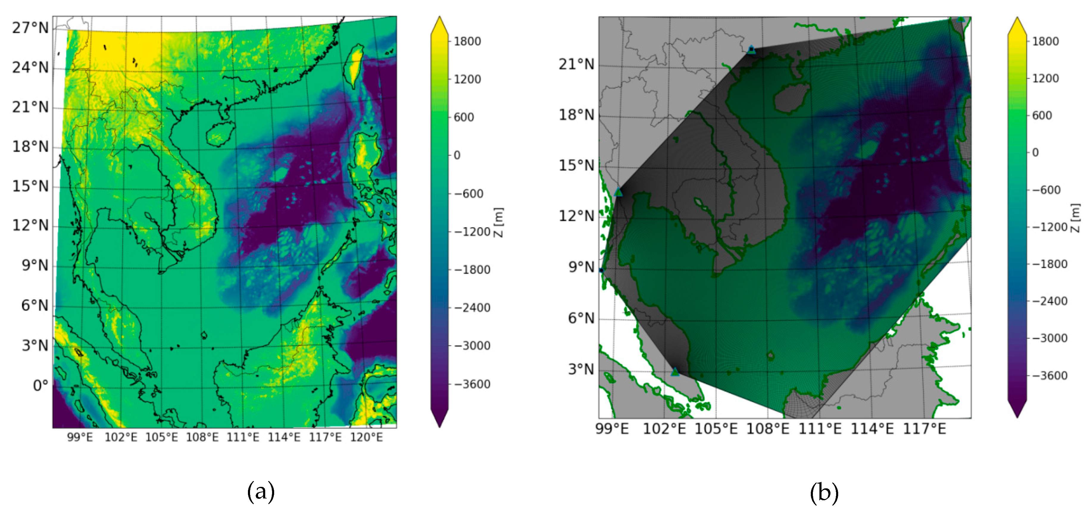
Our numerical simulation domain covers the whole South China Sea: −2.5–26° N, 97.0–125.0° E (Figure 3a). The curved grid is constructed with 498 × 498 gridlines with a resolution that varies in the direction of longitude from 2.6 to 6.6 km and in the direction of latitude from 3.7 to 8.0 km, following the detailed trend of the coast (Figure 3b). The General Bathymetry Chart of the Ocean (GEBCO) of the British Ocean Data Center was used to extract the bathymetry for offshore domains. Coastal topography maps with scales of 1/100,000 published by the Vietnam Administration of Seas and Islands were used for the domain details near the coast (Thuy et al., 2017) [9]. A time step of 10 s was selected for simulations in the case of both the tide-only and for the case of combined surge and tide.
The wind and pressure used in ROMS 2D were retrieved from there-analysis product ERA Interim as provided by the European Centre for Medium-range Weather Forecasts (ECMWF) with wind at 10m and atmospheric pressure at the sea surface in Network Common Data Form (NetCDF) format, with a global resolution of0.125° × 0.125° at 6-hourly intervals [15]. ROMS 2D interpolates the wind and pressure data to the orthogonal congruent coordinate system corresponding to the time step of the modeling time.
The wind stress τ S is usually estimated by the following equation:
τ S = ρ a C D U 10 | U 10 |
where ρa is the density of air, CD is the drag coefficient, and U 10 is the wind speed (m/s) at 10 m height. For monsoon-induced surge simulations, the formula for CD from Large and Pond [16] is as follows:
C D = { 1.2 × 10 3 for 4 < U 10 < 11 ms 1 10 3 ( 0.49 + 0.065 U 10 ) for 11 < U 10 < 25 ms 1
This algorithm has been used in many studies, such as in Dorman et al. [17], Samelson et al. [18], and Koracin et al. [19], and in particular for studies of storm surge in the South China Sea (Penget et al. [20] and Biet et al. [21]).

3. Results and Discussion

3.1. Astronomical Tide and Total Water Level at the Southeast Coast of Vietnam

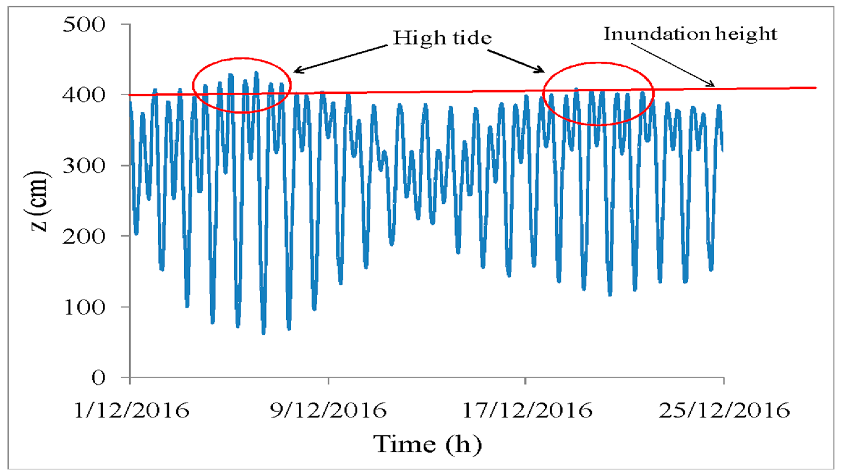
Figure 4 shows the peak astronomical tide of the months in 2016 and the peak of observed water levels at Vung Tau station in the period of 1987–2016. The highest of peak astronomical tides are in the months of January, February, March, October, November, and December. In this region, the main activities of typhoons, tropical depressions, and Northeast monsoons are also concentrated in these months. Therefore, in the first and last months of the year, the total water level will be high due to a combination of astronomical tides and the surges, as also shown in Figure 4. Figure 4 also shows that even though the peak of astronomical tide was smaller in October and November than in December, the total water level was higher. The Southeast coast consists of low land regions with a very gentle slope where a rise of only tens of centimeters of water level can significantly increase the risk of flooding and salt water intrusion. Note that the inundation height (Figure 5) corresponding to warning level III in this area is 400 cm. Because of the potentially serious impact of monsoon-induced surge, this study will therefore focus on the months from October to February.
In general, at Vung Tau station, there are two spring tide phases in a month. This is illustrated in Figure 5, where the time profile of observed water levels in December 2016 is shown. Therefore, this study mainly focuses on the analysis of the surge during the spring tide days.

3.2. Surge Induced by Monsoon and Tropical Cyclones in the Southeast Coast of Vietnam

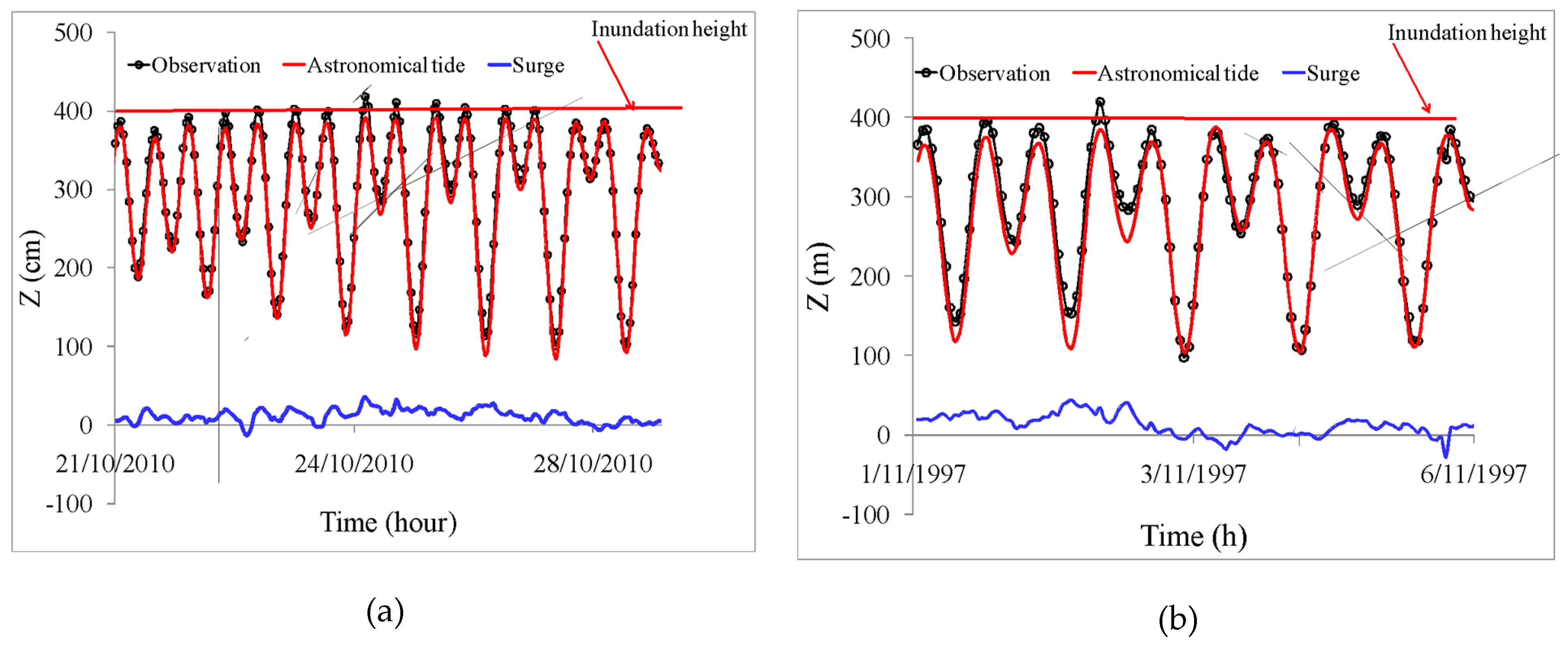
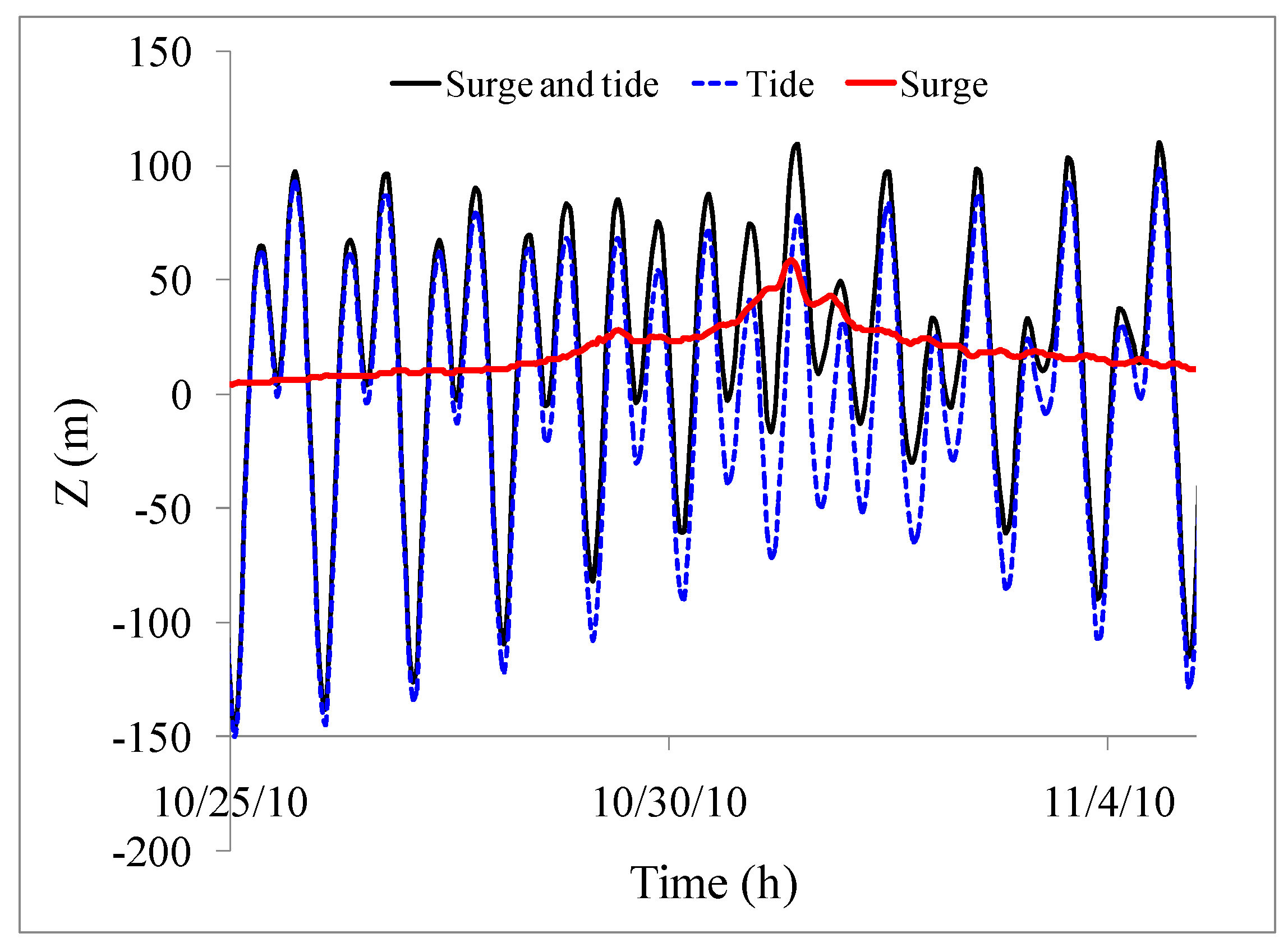
The surge height induced by monsoons and tropical cyclones was determined by subtracting the astronomical tide from the observed water level on all days of high tide. Figure 6a shows a time series of the observed water levels, astronomical tides, and surges in the last days of October and early November 2010. This is the time when the highest water was recorded at Vung Tau station. Changes in observed water level and surge show that even on days that were not high tide days, wind-induced surge contributed a considerable part of the rise in total water level extremes. The observed water levels, astronomical tides, and surge heights in the case of typhoon Linda’s landfall in November 1997 are shown in Figure 6b. Although the typhoon did not make landfall on the days with the highest astronomical tides, the storm surge height of about 45 cm contributed to a peak of total water reaching up to 420 cm.
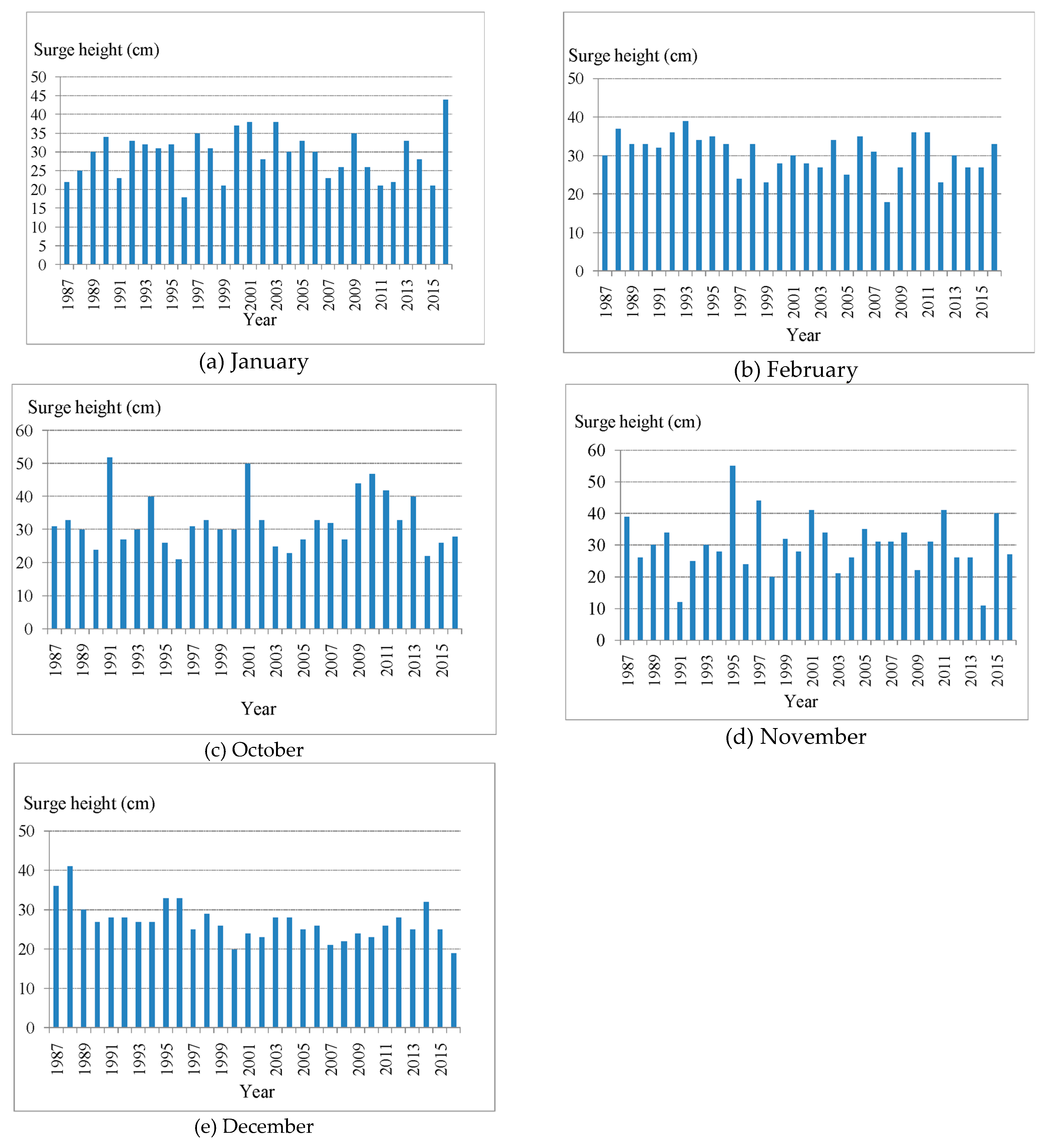
Figure 7a–e shows the highest of the peak surges at Vung Tau station during the spring tide days in January, February, October, November, and December in the period of 1987–2016.A frequency analysis of the surge levels over 30 years was carried out as shown in Table 1. Based on the results of the analysis, some comments on the surge height at Vung Tau station during this period are as follows:
  • The surge heights do not follow a clear trend with regards to the time of increasing or decreasing heights.
  • Surge levels of 20 to 30 cm are predominant on the coasts, comprising 39.5% of the total number, followed by surge heights of less than 20 cm. Surge heights of over 40 cm occurred mainly in October and November in which the highest surge of 54 cm occurred in November 1995. This is the reason why, in October and November, although the peak tide was smaller than in December, the total water level was higher than in December.
The analysis of astronomical tide, total water level, and surge at Vung Tau station shows that in the Southeast coast of Vietnam, the largest surges occur between October and February. This area is less affected by typhoons and tropical low pressure systems, so the monsoon-induced surges are very significant. The contribution of the monsoon-induced surge will increase the total water level and consequently increase the impact of total water level on the low-lying terrain. Since the terrain is low and flat, it means that only a small increase in water level will have the potential to increase the inundation and salt intrusion in the area. Therefore, being able to predict the monsoon-induced surge in the spring tide phases in this coastal area becomes very important. The forecasting of monsoon-induced surges needs to be implemented in a numerical prediction model, and the model needs to be validated prior to use for operational forecasting. The validation of the numerical model for predicting monsoon-induced surges is presented in the section below.

3.3. Results of Simulations of Monsoon-Induced Surgeduring Spring Tides in the Southeast Coast of Vietnam

3.3.1. Validation of the Numerical Model for Tide

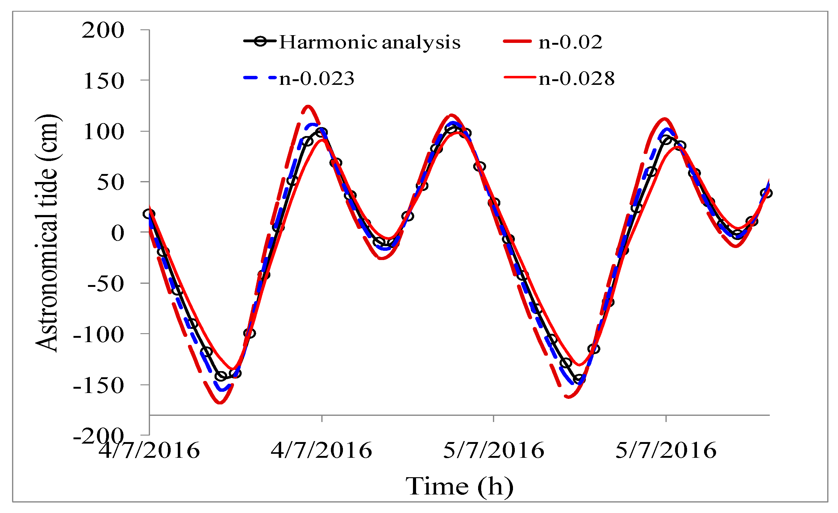
First, the model needs to be verified and validated for tide in the study area. Figure 8 shows the comparison of the tides calculated by ROMS 2D for three values of the Manning coefficient (n = 0.02, 0.023, and 0.028) with harmonic analysis data at Vung Tau station in July 2016. Note that in this case, the datum is at the mean sea level, and the two methods used the same thirteen tide constituents. A roughness coefficient of 0.023 gives the smallest error between numerical results and the harmonic analysis data. By using this coefficient, the numerical model was validated for April and November 2016. The results in Figure 9a,b shows that the model simulates both the phases and the tide amplitudes quite well, with maximum errors of around 44 cm (37 cm).Typical values for Root Mean Square Error (RMSE) are 19 cm (17 cm), and the correlation index is 0.93 (0.95) for April (November).Therefore, the roughness coefficient obtained from the tidal validation will be used in the simulation of monsoon-induced surge below.

3.3.2. Validation of the Numerical Model for Surge Induced by Monsoon

In order to evaluate the capability of ROMS 2D in predicting monsoon-induced surge in the Southeast coast of Vietnam, we selected the days of two recorded spring tide phases, one at the end of October and early November 2010 and one at the end of October 2013. We conducted two sets of numerical simulations: one of tide-only and one of surge with tide. As shown in Figure 10, firstly, the case of surge with tide was simulated. Secondly, the tide-only simulation was conducted to extract the surge level, taking into account the surge and tide interaction as follows: Hsurge = Hsurge+tideHtide. Finally, the surge was computed at the mean sea level.

Monsoon-Induced Surges during the Spring Tide in Late October and Early November 2010

During this spring tide phase, the sea level started to rise from 29 October to end on 1 November 2010. There were several times when the surge height was over 40 cm; the highest was 47 cm at 08:00 on 30 October 2010. Figure 11a,b shows the wind and pressure re-analysis field at 07:00 on 27 October (Figure 11a) and at 07:00 on 31 October 2010 (Figure 11b). During this time, the Northeast monsoon came far to the south and the wind speed increased to level 6–7 on the Beaufort scale (10–18 m/s) on 31 October. The high wind speed and long duration led to the generation of large and persistent water rises in this high tide period, which resulted in the inundation of many areas along the Southeast coast, including Ho Chi Minh City, located 40 km from the coast.
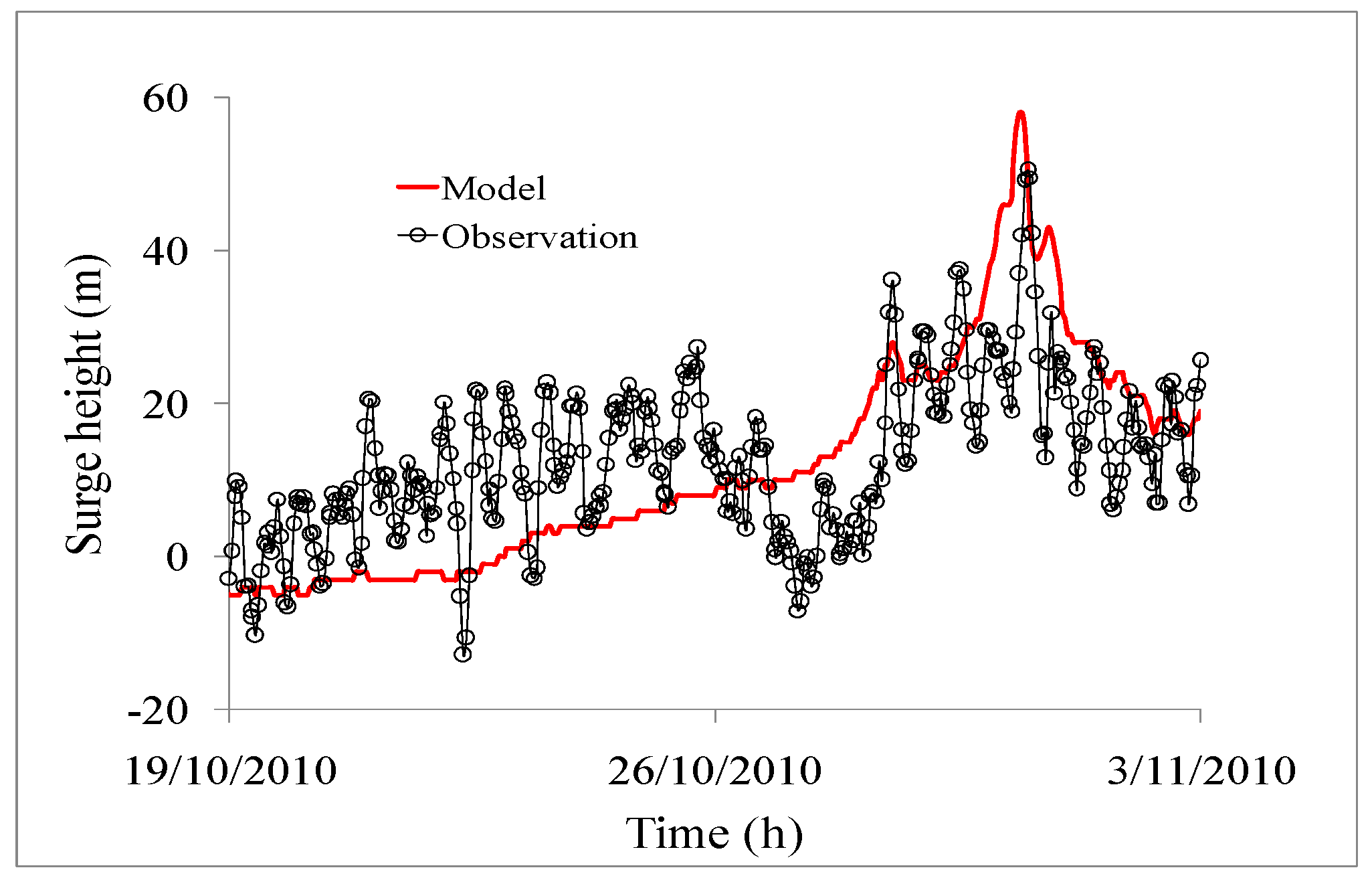
The simulation of surge induced by strong winds from 25 October to 3 November 2010, shows that the maximum surge height in this area is up to 70 cm on the Southeastern coast of Vung Tau (Figure 12). In order to establish a comparison, the frequency of the simulated data was changed from 10 s (time step of the model) to one hour (period between two measurements). The comparison of surge heights calculated by model and observations at Vung Tau station are shown in Figure 13. The maximum errors were around 28 cm, and typical values for RMSE were 10 cm with a peak surge of 7 cm.

Monsoon-Induced Surges during the Spring Tide in October 2013

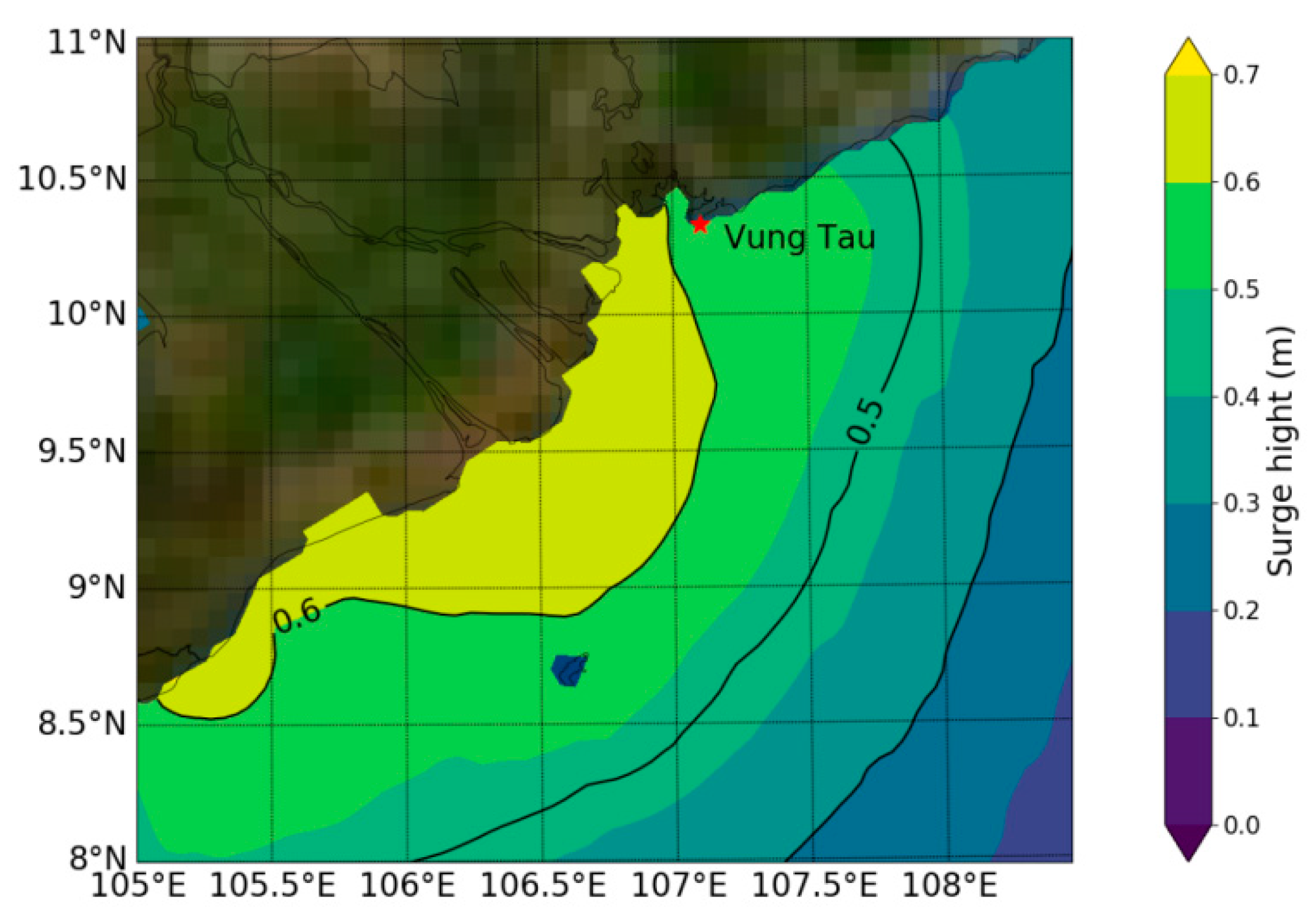
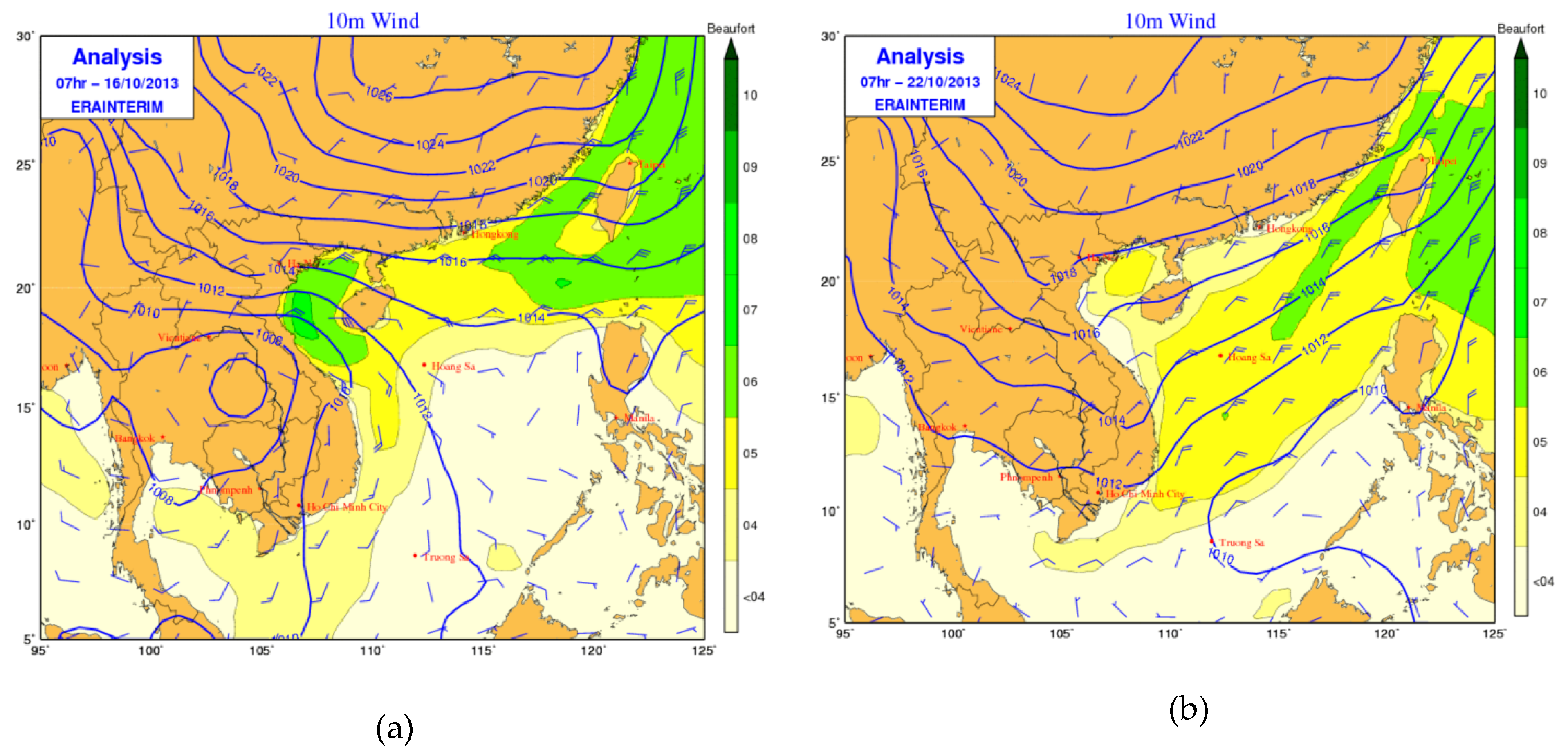
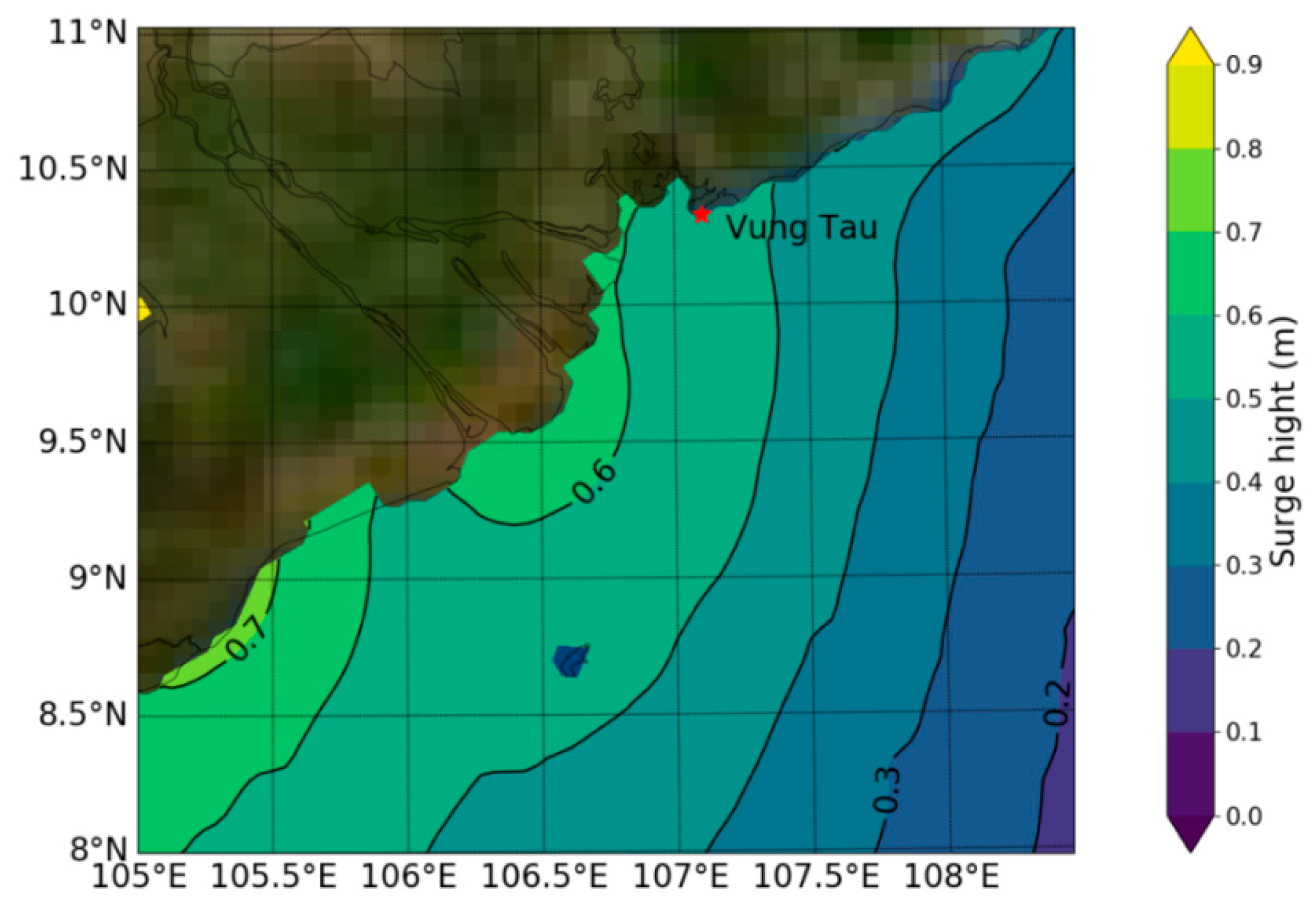
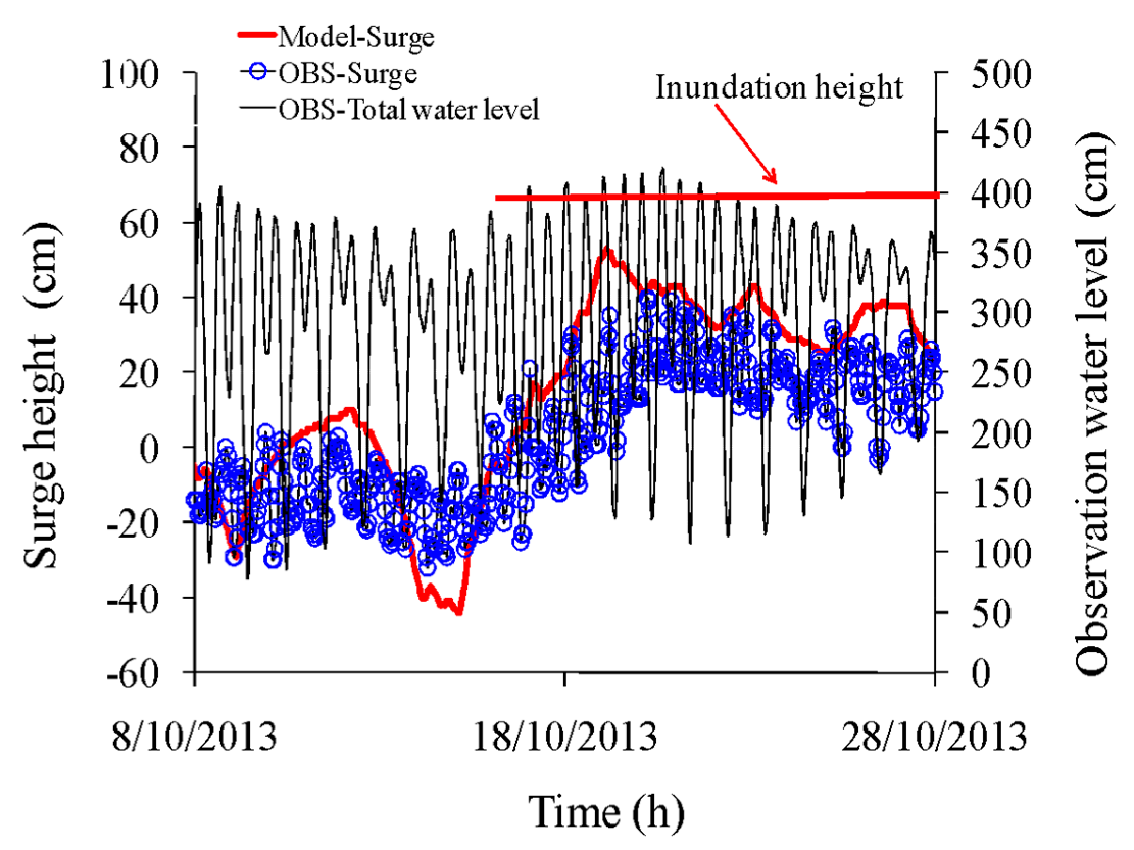
The second spring tide phase used for the numerical validation was on the dates at the end of October 2013. A historic high tide was recorded in Ho Chi Minh City, with a maximum water level at Vung Tau station of 420 cm, which was over the threshold inundation depth at the area. At that time, the Northeast monsoon came far to the South, as illustrated by the re-analysis of wind and pressure (Figure 14a,b). Strong winds and high tide combined with heavy rain were the cause of record flooding in the Southeast coast of Vietnam. Figure 15 shows the spatial distribution of the peak surge levels simulated by the ROMS 2D model. The maximum surge level reached up to 0.7 m on the coastal areas. The results of the series of simulations are shown in Figure 16, which presents comparisons between observations (OBS-Surge) and calculations (Model-Surge) at Vung Tau station. From the results, a similar tendency was found between model and observation, although the values for RMSE were 18 cm and errors of peak surge were 17 cm.
The errors of surge simulation may come from two sources: (1) insufficient resolution of wind field re-analysis; and (2) the surge height, in the case of monsoon, was not high, and there was noise from analyzed surge observation data. Despite this fact, the model can be used for forecasting the surge height during the monsoon.

4. Conclusions

The Southeast coast of Vietnam has a dense population and many important economic facilities along its coastline, which are vulnerable to storm surges due to the low plains and a large estuary system. High sea levels are possible during the strong Northeast monsoon surges (October–February) if they coincide with spring tides. This would usually lead to floods in the coastal areas. In this study, the monsoon-induced surge during spring tides in the Southeast coast of Vietnam was analyzed based on observed tides at the Vung Tau station. In particular, the surge was determined by removing the astronomical tidal oscillations from the observed water level. A harmonic analysis was used to calculate the astronomical tide. The observed water level data over 30 years (1987–2016) was collected for analysis. Next, ROMS 2D was used to simulate the surge heights in two spring tide phases in order to assess the capacity of the model to simulate surge height. The main results are summarized as follows:
  • The change of peak surges does not show a clear trend.
  • Surge levels of 20 to 30 cm are predominant on the coasts, comprising 39.5% of the total number. Peak surge heights over 40 cm occurred mainly in October and November. This is a reason why most of the high spring tide in this area occurred in October and November even though the peak tide was smaller than in December.
ROMS 2D implemented for the South Coast of Vietnam has reproduced relatively well the wind-induced surge during high tides. Therefore, we conclude that it is possible to apply this model for the operational forecast of monsoon-induced surges in this area.
In this study, monsoon-induced surge at the shore line has been considered. A very interesting subject to be considered for future research would be to use a coupled river and ocean model in order to investigate the effect of river conditions on surges in addition to the coastal and river site inundation.

Author Contributions

N.B.T. and T.Q.T. collected field data and analyses. N.B.T, L.R.H. and C.W. developed the study design. L.R.H. and C.W. provided expert knowledge used in data analysis and interpretation. All co-authors contributed to the writing of the manuscript.

Acknowledgments

This research is funded by Vietnam National Foundation for Science and Technology Development (NAFOSTED) under grant number 105.06-2017.07 (method and numerical model) and by the Ministry of Science and Technology of Vietnam under grant number ĐTĐL-C.35/15 (re-analyses and tide data), and partially funded by the Norwegian Agency for Development Cooperation (NORAD; Hole and Wettre), which the authors gratefully acknowledge.

Conflicts of Interest

The authors declare no conflict of interest.

References

  1. Tuan, L.A. Hydro-Meteorology on the Plain in Mekong River. Ph.D. Thesis, Can Tho University, CanTho, Vietnam, 2000; 91p. (In Vietnamese). [Google Scholar]
  2. Tan, P.V.; Thanh, N.D. Climate Change in Vietnam: Some Research Findings, Challenges and Opportunities in International Integration. Vietnam Natl. Univ. J. Sci. 2013, 29, 42–55, (In Vietnamese, Abstract in English). [Google Scholar]
  3. Du, D.T.; Hole, L.R.; Tran, A.D.; Hoang, D.C.; Thuy, N.B. Verification of forecast weather surface variables over Vietnam using the National Numerical Weather Prediction System. Adv. Meteorol. 2016, 2016. [Google Scholar] [CrossRef]
  4. Minh, P.T.; Lan, L.T.X. Analyze the spring tide in Ho Chi Minh City from 2006 to 2011. Sci. Tech.-Meteorol. J. 2012, 347, 26–30. (In Vietnamese) [Google Scholar]
  5. Sao, N.T. Storm surge predictions for Vietnam coast by Delft3D model using results from RAMS model. J. Water Resour. Environ. Eng. 2008, 23, 39–47. [Google Scholar]
  6. Thang, N.V. Building Scheme for Storm Surge Prediction in Hai Phong Coastal Zone. Ph.D. Thesis, Vietnam Institute of Meteorology, Hydrology and Environment, Hanoi, Vietnam, 1992; 120p. (In Vietnamese). [Google Scholar]
  7. Thuy, V.T.T. Storm surge modeling for Vietnam’s coast. Master’s Thesis, Delft Hydraulic, Delft, The Netherlands, 2003; 140p. [Google Scholar]
  8. Chien, D.D. Researching the Scientific Basis to Assess the Storm Surge in the Sea Areas from Quang Binh to Quang Nam. Ph.D. Thesis, University of Science-Vietnam National University, Hanoi, Vietnam, 2015; 117p. (In Vietnamese). [Google Scholar]
  9. Thuy, N.B.; Cuong, H.D.; Tien, D.D.; Chien, D.D.; Kim, S.Y. Assessment of changes in sealevel caused by Typhoon No. 3 in 2014 and forecast problems. Sci. Tech.-Meteorol. J. 2014, 647, 16–20. (In Vietnamese) [Google Scholar]
  10. Ninh, P.V.; Quynh, D.N.; Manh, D.V. Surge Induced by Strong Monsoon; Project of 48B.02.02; Institute of Mechanics-Vietnam: Hanol, Vietnam, 1991. [Google Scholar]
  11. Thanh, H.T. The Variation of Sea Level in Coastal Zone of Vietnam. Ph.D. Thesis, Institute of Meteorology, Hydrology and Environment, Hanoi, Vietnam, 2011; 91p. (In Vietnamese). [Google Scholar]
  12. Thuy, N.B.; Sooyoul, K.; Chien, D.D.; Dang, V.H.; Cuong, H.D.; Wettre, C.; Hole, L.R. Assessment of Storm Surge along the Coast of Central Vietnam. Coast. Res. J. 2017, 33, 518–530. [Google Scholar] [CrossRef]
  13. Regional Ocean Modeling System (ROMS). Available online: www.myroms.org (accessed on 20 July 2017).
  14. TPXO Global Tidal Solutions. Available online: http://volkov.oce.orst.edu/tides/ (accessed on 20 July 2017).
  15. ERA-Interim. Available online: https://www.ecmwf.int/en/forecasts/datasets/archive-datasets/reanalysis-datasets/era-interim (accessed on 3 January 2018).
  16. Large, W.G.; Pond, S. Open Ocean Momentum Flux Measurements in Moderate to Strong Winds. J. Phys. Oceanogr. 1981, 11, 324–336. [Google Scholar] [CrossRef] [Green Version]
  17. Dorman, C.E.; Holt, T.; Rogers, D.P.; Edwards, K. Large-scale structure of the June–July 1996 marine boundary layer along California and Oregon. Mon. Weather Rev. 2000, 128, 1632–1652. [Google Scholar] [CrossRef]
  18. Samelson, R.M.; Barbour, P.; Barth, J.; Bielli, S.; Boyd, T.; Chelton, D.; Kosro, P.; Levine, M.; Skyllingstad, E.; Wilczak, J. Wind stress forcing of the Oregon coastal ocean during the 1999 upwelling season. J. Geophys. Res. 2002, 107. [Google Scholar] [CrossRef]
  19. Koracin, D.; Dorman, C.E.; Dever, E.P. Coastal perturbations of marine layer winds, wind stress, and wind stress curl along California and Baja California in June 1999. J. Phys. Ocean 2004, 34, 1152–1173. [Google Scholar] [CrossRef]
  20. Peng, S.; Li, Y.; Xie, L. Adjusting the Wind Stress Drag Coefficient in Storm Surge Forecasting Using an Adjoint Technique. J. Atmos. Ocean Technol. 2015, 30, 590–608. [Google Scholar] [CrossRef]
  21. Bi, X.; Gao, Z.; Liu, Y.; Liu, F.; Song, Q.; Huang, J.; Huang, H.; Mao, W.; Liu, C. Observed drag coefficients in high winds in the near offshore of the South China Sea. J. Geophys. Res. Atmos. 2015. [Google Scholar] [CrossRef]
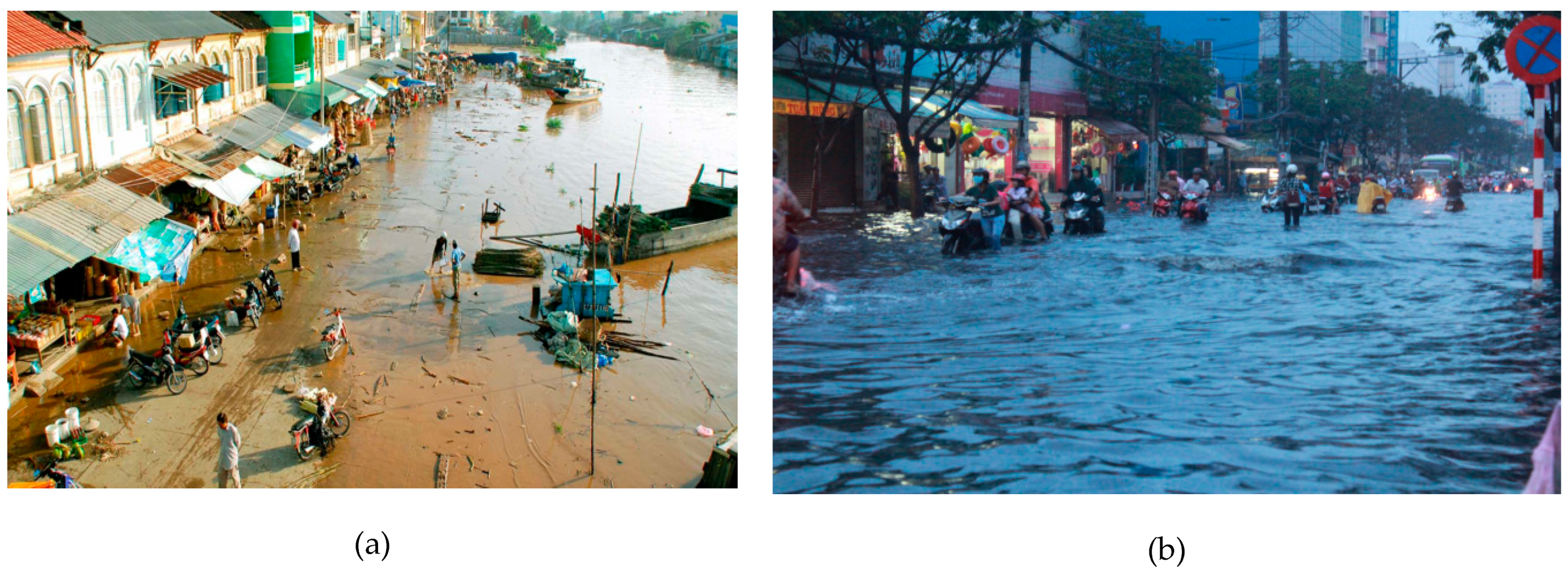
Figure 1. Flooding due to spring tides in the South province of Vietnam. (a) The center of Ca Mau province at the spring tide in 31 October 2010. (b) Ho Chi Minh City during the historic spring tide in 26 October 2011.
Geosciences 09 00072 g001
Figure 2. The study area and location of Vung Tau station.
Geosciences 09 00072 g002
Figure 3. (a) The domain of the grid and bathymetry. (b) Grid for the South China Sea and coastal areas of Vietnam.
Geosciences 09 00072 g003
Figure 4. The peak astronomical tide of month in 2016 and maximum observed water level in the period 1987–2016.
Geosciences 09 00072 g004
Figure 5. Time profile of water level variation at Vung Tau station in December 2016.
Geosciences 09 00072 g005
Figure 6. Time series of observed water levels, astronomical tides and surges in Vung Tau (a) during spring tide phase in late October and early November 2010 and (b) during typhoon Linda (November 1997).
Geosciences 09 00072 g006
Figure 7. Surge heights at Vung Tau station in 1987–2016. (a) January, (b) February, (c) October, (d) November and (e) December.
Geosciences 09 00072 g007
Figure 8. Comparison of tides predicted by two-dimensional Regional Ocean Model System (ROMS 2D) for three values of the Manning coefficient (n) with harmonic analysis at Vung Tau station in July 2016.
Geosciences 09 00072 g008
Figure 9. Comparison of tides predicted by ROMS 2D with harmonic analysis at Vung Tau in (a) April 2016 and (b) November 2016.
Geosciences 09 00072 g009
Figure 10. Time series of calculated only tides (“Tide”), surges coupled with tides (“Surge + Tide”), and surges with "Tide" extracted from “Surge + Tide” at Vung Tau station during the period of 25 October to 4 November 2010.
Geosciences 09 00072 g010
Figure 11. Wind and pressure re-analyzed on (a) 27 October 2010 and (b) 29 October 2010.
Geosciences 09 00072 g011
Figure 12. Maximum surge height due to monsoon during 25 October to 3 November 2010.
Geosciences 09 00072 g012
Figure 13. Comparison between numerical and observed surge heights at Vung Tau station during 25 October to 3 November 2010.
Geosciences 09 00072 g013
Figure 14. Wind and pressure re-analyzed on (a) 16 October 2013 and (b) 22 October 2013.
Geosciences 09 00072 g014
Figure 15. Maximum surge during 16–26 October 2013.
Geosciences 09 00072 g015
Figure 16. Comparison between numerical and observed surge heights at Vung Tau station during 16–28 October 2013.
Geosciences 09 00072 g016
Table 1. Frequency of surge levels in Vung Tau station in 1987–2016.
Surge Height (cm)FrequencyPercentage (%)
HND < 2015942.7
20 ≤ HND < 3014739.5
30 ≤ HND < 405213.9
HND > 40143.7