Article

A Hydrogeologic Framework for Understanding Local Groundwater Flow Dynamics in the Southeast Deschutes Basin, Oregon, USA

1
Water Resources Graduate Program, Oregon State University, Corvallis, OR 97331, USA
2
Department of Animal and Rangeland Sciences, Ecohydrology Lab, Oregon State University, Corvallis, OR 97331, USA
3
Institute for Water and Watersheds, Oregon State University, Corvallis, OR 97331, USA
4
OSU Extension Service-Crook County (emeritus), Oregon State University, Prineville, OR 97754, USA
*
Author to whom correspondence should be addressed.
Geosciences 2019, 9(2), 57; https://doi.org/10.3390/geosciences9020057
Submission received: 23 December 2018 / Revised: 14 January 2019 / Accepted: 17 January 2019 / Published: 24 January 2019

Abstract

:
Understanding local hydrogeology is important for the management of groundwater resources and the ecosystems that depend on them. The main objective of this study conducted in central Oregon, USA was to characterize the hydrogeologic framework of a part of the semiarid Upper Deschutes Basin. Information on local geology and hydrology was synthesized to construct a hydrogeologic framework and a conceptual model of groundwater movement in shallow and previously unmapped deeper aquifers. Study results show that local geology drives many of the surface water and groundwater connections that sustain groundwater-related ecosystems and ranching-related activities in the geographical area of interest. Also, the findings of this study suggest that ecohydrological investigations can be used to mitigate concerns regarding groundwater development. Likewise, newly-developed conceptual models of the hydrogeology of previously unstudied areas within a groundwater basin undergoing regulation offer opportunities to not only address concerns regarding integrated surface water–groundwater interactions but also provide supplemental sources of water for nearby areas undergoing groundwater depletion through proposed bulk water transfers.

1. Introduction

Groundwater is an essential resource worldwide, relied upon for agriculture, energy production, human consumption, and ecosystem services [1]. In many areas of the arid and semiarid western United States, the increasing demand for water resources, due in part to rising population growth dynamics and severe drought conditions, has led to substantial increases in groundwater use to compensate for decreasing surface water supplies. This growing dependence on groundwater has prompted the need to identify local and regional groundwater sources to satisfy the growing demand in the western states. The increasing reliance on groundwater resources to satisfy population growth demands is also putting additional pressure on the already water-scarce ecosystems in many western locations. Over the last two decades, a series of actions have been implemented, including the development of groundwater mitigation plans in several states (e.g., Arizona, Oregon, and Washington) [2] and specific legislation in others (e.g., California) [3], to promote the more responsible use of groundwater resources while protecting the environment. These mitigation programs and associated legislation have increased awareness of the importance to improve our understanding of groundwater–environment relationships, particularly on the role of groundwater to maintain or enhance ecosystem functions. Some ecosystems rely primarily on groundwater sources to support their composition, structure, and function [4]. Groundwater-related ecosystems such as lakes, rivers, springs, wetlands, or phreatophytic and subterranean ecosystems [5] are often identified by vegetative communities that depend on surface and subsurface expression of groundwater [6]. Even though the distribution of groundwater-related ecosystems is not yet fully understood, they have been gaining recognition for their important role in terrestrial biodiversity [7,8], ecosystem services [4], and for maintaining of streamflow [9]. In Oregon, a recent study by Brown et al. [10] found that more than a third of the state’s watersheds contain some form of groundwater-related ecosystems, with the majority of those being dependent on springs.
Groundwater-related ecosystems are important for human well-being and ecological function [11]. The sustainability of these local and regional water systems can be tied to a proper understanding of the geological and physical processes that lead them to exist in the first place. To better manage, protect, and sustain groundwater-related ecosystems, it is essential to enhance our understanding of the spatial and temporal domains through which groundwater flow occurs. Groundwater flow occurs on different spatial and temporal scales from points of recharge to discharge. It ranges from extensive regional systems covering large basins where groundwater moves long distances over long time scales, to small local flow systems within these larger basins that cover smaller areas over short time scales. Local flow systems are typically shallow systems often characterized by the presence of small springs not far from areas of recharge [12]. A study by Aldous et al. [13] investigated the linkages between the hydrogeologic setting and the presence of groundwater-dependent ecosystems in the montane setting of the Deschutes Basin of central Oregon. They found some of these systems to be associated with areas of low-permeability strata and local recharge systems [13]. This seems to be the case at our Camp Creek Paired Watershed Study (CCPWS) site in central Oregon, where we have conducted extensive research on the hydrologic response to vegetative management practices such as western juniper (Juniperus occidentalis) removal. We found there was a relatively rapid response of the shallow groundwater system to the seasonal winter precipitation and spring runoff patterns of the region. Greater aquifer recharge and springflow levels were observed in the watershed where juniper was removed in 2005 [14]. Shallow groundwater at this site is relatively young, suggesting there are short time scale connections from recharge to discharge in the shallow aquifer [15]. We hypothesized that local geology plays an important role in modulating the highly dynamic surface water and groundwater relationships we observed.
In central Oregon, the Deschutes Groundwater Mitigation Program was developed in 2002 to ameliorate the effects of new groundwater extractions on flows within specific “zones of impact” in the basin [16]. As part of this effort, a comprehensive hydrogeologic study of the Upper Deschutes Basin was completed by the U.S. Geological Survey to provide information on groundwater resources to meet central Oregon’s growing groundwater demands [17]. Given the regional scope of the study, some of the local systems, such as in the case of the basin’s southeastern section where our CCPWS site is located, were left out, and no meaningful information to inform our case was available. In this study, we aimed to enhance our understanding of the local geological features that influence surface water and groundwater connections driving groundwater-related ecosystem function and production activities in this part of the basin. The study objective was to characterize the hydrogeologic framework for an area of interest that includes our CCPWS site in the southeastern-most portion of the Upper Deschutes Basin.

2. Materials and Methods
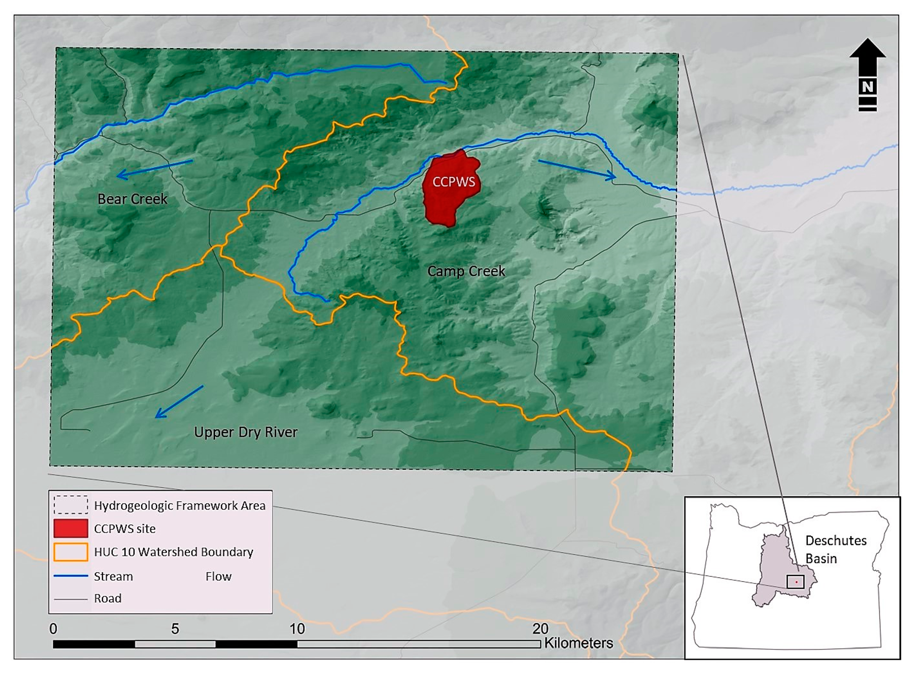
2.1. Study Site

This study took place in central Oregon, in the southeastern-most portion of the Deschutes Watershed. This area is within the John Day Ecological Province, a semiarid region with total precipitation ranging from 250–380 mm year−1 [18]. Data from the CCPWS onsite instrumentation shows average annual precipitation for the period of record (2009–2017) was 358 mm, and longer-term (1961–2017) annual precipitation was 322 mm at the Barnes station, 10 km southeast of CCPWS [14]. The larger extent of this study included a 280 km2 region northeast of Brothers, Oregon. This larger extent was used to examine the broader hydrogeology that encompasses the smaller extent of our study site where most of the field data collection took place (Figure 1). The landscape is dominated by western juniper and big sagebrush (Artemisia tridentata) rangelands used mostly for cattle grazing. The meadows of Camp Creek are largely grasslands (various species) utilized as summer grazing pastures that are divided by low dams, remnant of sub-irrigated pastures used for growing hay in the 1950s and 1960s. Also, there are some relatively small pockets of irrigated land used to grow hay that use central pivots for groundwater extraction. Besides livestock, these rangelands host numerous wildlife species typical of central Oregon, including mule deer (Odocoileus hemionus), pronghorn (Antilocapra americana), and various avian species, that benefit from surface and subsurface water available during most of the year, except during the late summer months when most of the landscape is typically dry. The CCPWS study site (43.96° latitude; −120.34° longitude) encompasses two watersheds and the riparian valley they drain into covering approximately 4 km2. The site ranges from 1370–1524 m in elevation. Streams in the watersheds are ephemeral, with seasonal flows occurring during years with substantial snowmelt runoff, otherwise only flowing in response to occasional convective storms. The study site is instrumented to monitor multiple hydrologic variables including shallow groundwater, streamflow, springflow, soil moisture, and weather data [14].
Regarding the geologic setting of the study area, the High Lava Plains of central Oregon are a 240 km long and 80 km wide rectangular plateau trending generally northwest to southeast. It is bordered by the Basin and Range Province to the south, the Blue Mountains to the north, the Owyhee Uplands to the east, and the Cascade Range to the west [19]. The High Lava Plains are characterized by a region of irregularly spaced west–northwest trending en echelon normal faults known as the Brothers Fault Zone [20]. The fault zone was created by a clockwise motion that twisted Oregon throughout the Cenozoic era [19]. Our study site sits near the northern border of the High Lava Plains, just south of the Maury Mountains. The local surface geology is classified as lower tertiary deposits of the Clarno and John Day Formations with valley bottoms filled by alluvium [21]. The John Day Formation is characterized by tuffs, tuffaceous sedimentary rocks, ash flow deposits, and rhyolites [21]. The permeability of the John Day is very low (wells typically produce < 40 L min−1) [22], and the formation is viewed as the lower confining unit of the larger Upper Deschutes regional groundwater system [17]. The Clarno Formation, which covers most of our site, is older and deeper than the John Day Formation and is characterized by andesite flows, breccias, and volcanogenic sedimentary rocks [21]. The Clarno Formation is also recognized as a poor water-bearing unit with wells located within it having yields of only a few liters per minute [23,24].

2.2. Hydrogeologic Framework

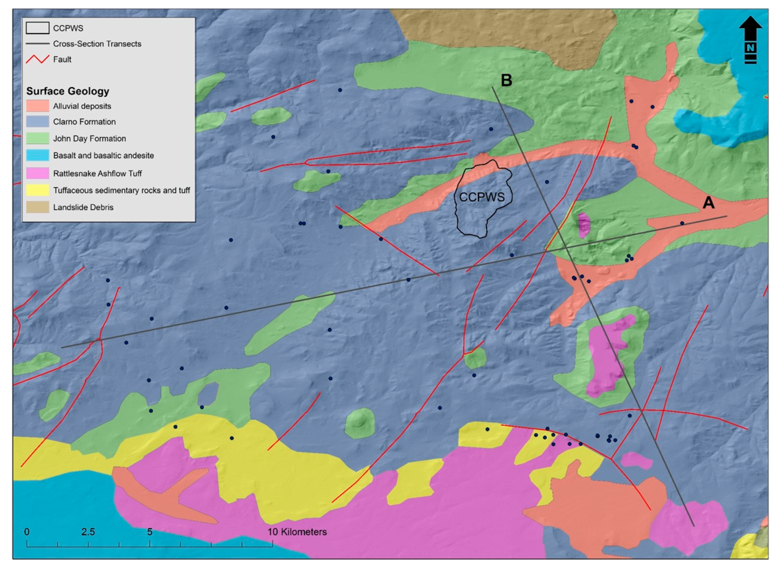
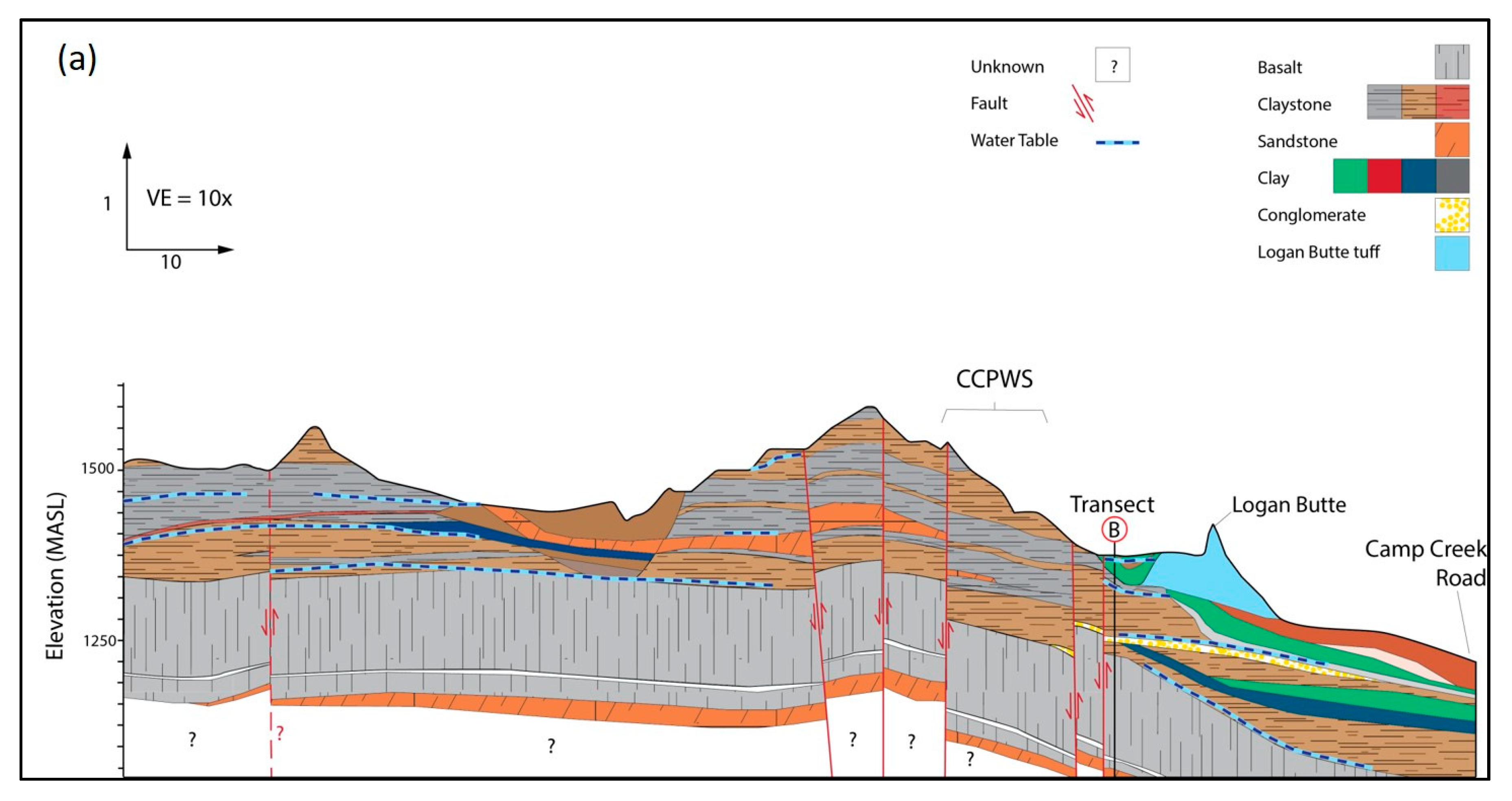
2.2.1. Geologic Cross-Sections

To gain a finer understanding of the hydrogeologic structure underlying the area of interest, we constructed two geologic cross-sections (A and B) illustrated on a surface geology map (Figure 2). The two cross-sections are oriented nearly perpendicular to each other and provide a three-dimensional representation of the geology for the CCPWS. Cross-section A was oriented west–southwest and east–southeast (WSW–ESE), and cross-section B was oriented north–northwest and south–southeast (NNW–SSE). Subsurface geology data were compiled from well borehole descriptions gathered from the Oregon Water Resources Department (OWRD) [25] and from two deep oil and gas exploration wells [26]. Borehole data were plotted on a regional topographic map and boreholes within 2 km of each transect were projected in, using each borehole as a discrete point of subsurface geology.

2.2.2. Groundwater Flow

We developed a potentiometric surface map using static water level data obtained from OWRD well logs, National Hydrography Dataset (NHD) spring elevation, and water levels in CCPWS observation wells installed as part of this study. We added three springs at our study site to the NHD spring data [27]. Data from the State of Oregon observation wells in the area do not show any significant water table declines over their period of record. Therefore, a static water table from the time of drilling was a good approximation of water table levels. Contour lines were created in two ways. First, using ArcMap (version 10.4.1, Esri; Redlands, CA, USA), a surface with 30 m contours was created using the 3D analyst surface contour tool. Second, using water table elevation data, contours were drawn by hand in Adobe Illustrator (version CS6, Adobe Systems Inc.; San Jose, CA, USA), taking into account topography and reasonable continuations of water table elevation beyond the study area boundary. Contours with a higher level of uncertainty were distinguished with dashed curves. A groundwater flow conceptual model was developed using data derived from the geologic cross- sections described above and from the surface water and groundwater relationships observed at our study site as reported by Ochoa et al. [14].

3. Results

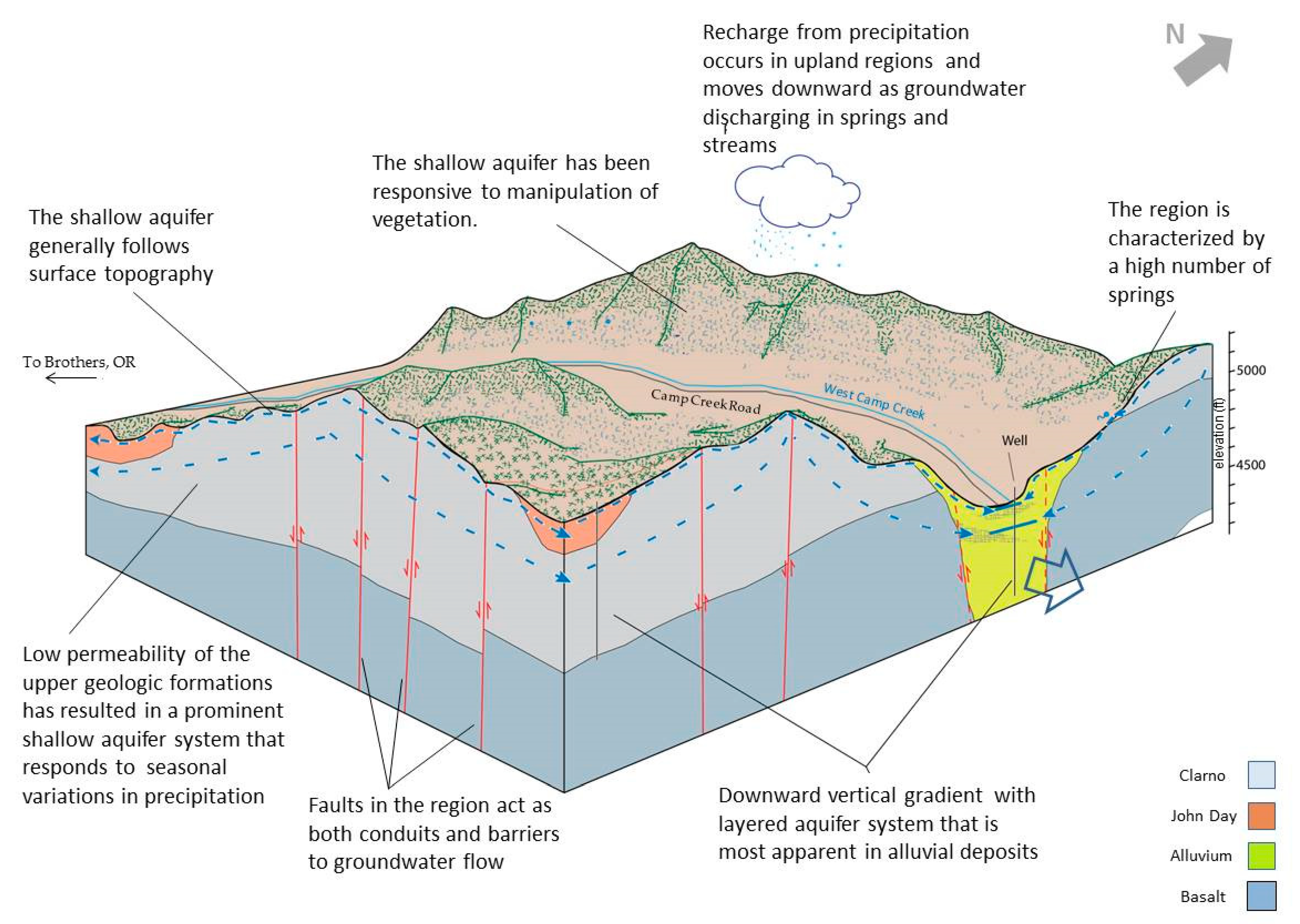
3.1. Hydrogeologic Framework

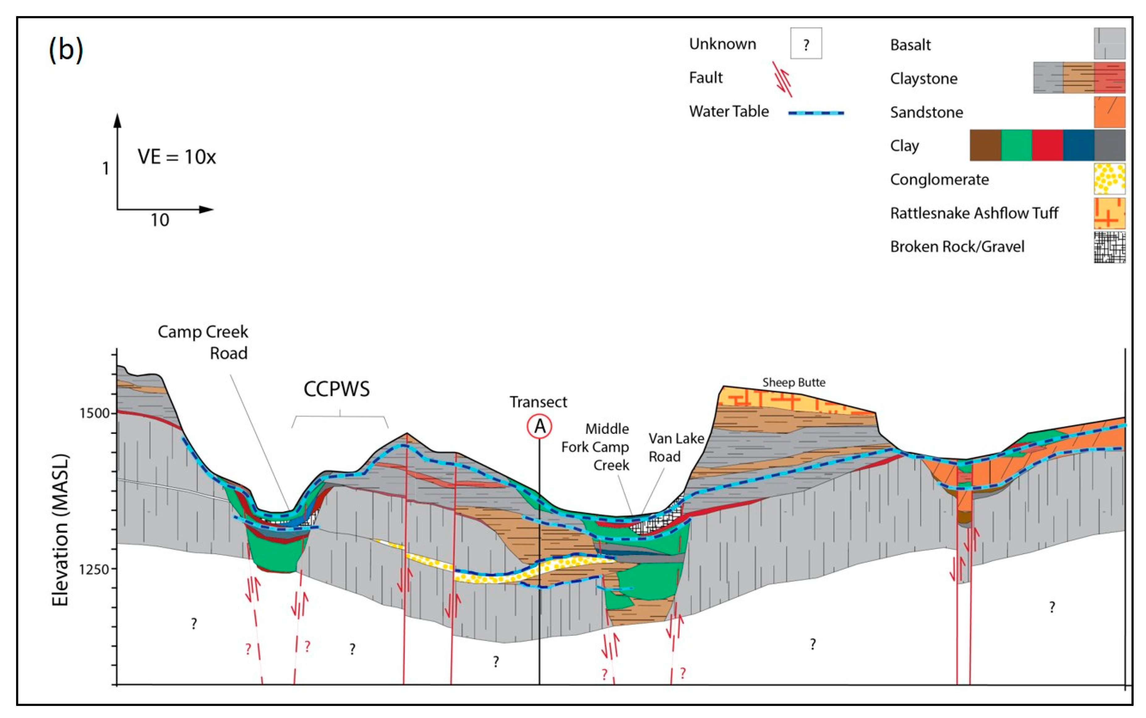
3.1.1. Geologic Cross-Sections

Figure 3a,b show cross-sectional views of the region’s subsurface geology. As depicted in both figures, the upper strata in our study area are composed predominantly of layers of rock types common to the Clarno and John Day Formations. The most superficial portion (150–200 m) consists primarily of claystone, sandstone, and conglomerate. Valleys in the region are the result of faults creating a horst–graben structure common in the Brothers Fault Zone [28].

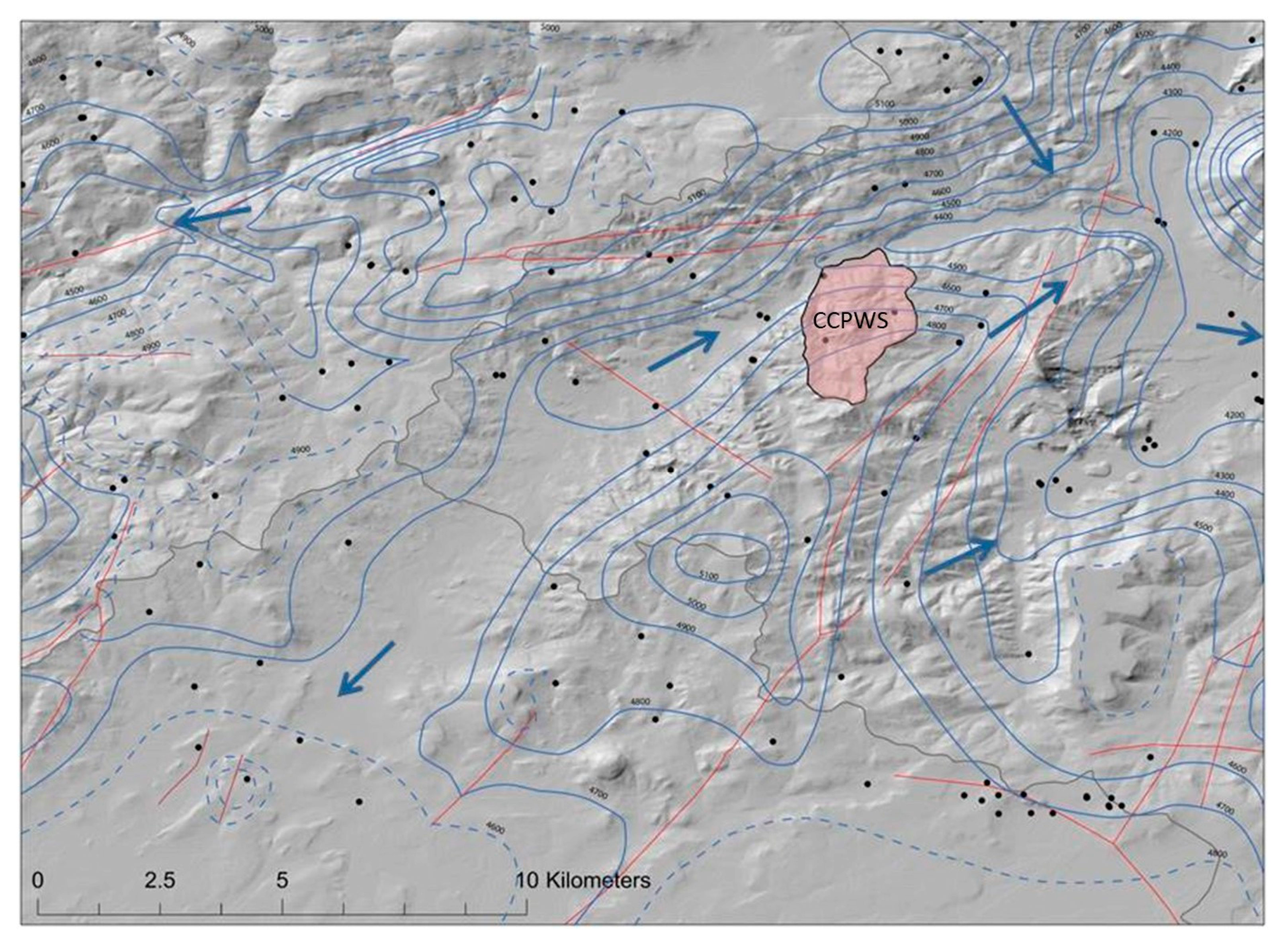
3.1.2. Groundwater Flow

The potentiometric surface map generated from static groundwater level and spring elevation data revealed that the water table generally follows surface topography across the study area. Overall, groundwater moves from higher elevations of the north and center of the study area to the lower elevation areas in the valleys, to its lowest point at the eastern end of our study area. In the valleys, a downward vertical gradient characterized by the presence of several aquicludes and aquitards have resulted in a multilayered aquifer system. The presence of faults plays an important role in groundwater circulation. In some parts of the study area, faults appear to act as barriers to water movement, causing sharp drops in water level from one side of a fault to the other. Similar behavior was described in a recent study within the Deschutes Watershed in the Sisters Fault Zone [29]. Also, the appearance of springs was noted as possible evidence of faults acting as a barrier to horizontal groundwater flow when water tries to move perpendicular to the direction of faults. In other cases, the faults may be acting as conduits for groundwater flow when fault and circulation direction are parallel. When there are several faults close to each other, as is the case in an area southeast of the CCPWS site, the group of faults appears to act together, creating anisotropic permeability architecture reflected as the stretched potentiometric contours in the northeastern portion of the study area (Figure 4).

3.2. Conceptual Model

The conceptual model illustrated that the region is dominated by low-permeability geology, characteristic of the John Day and Clarno Formations superimposed on faults, which serve as both conduits and barriers to groundwater circulation (Figure 5). This low permeability of the deeper sedimentary strata has resulted in a prominent, shallow unconfined aquifer system, which primarily follows surface topography. In this shallow aquifer system, groundwater moves on short one year scale cycles that are reflected in seasonal water table and springflow fluctuations. There is no specific data available to inform the hydrogeologic regime of the aquifer at our study site. Broader regional information derived from studies conducted mostly to the west of our study site show hydraulic conductivity values ranging from 2.7–700 m d−1, and median transmissivity values ranging from 177–214 m2 for values for most Deschutes Formation wells [30]. The shallow unconfined aquifer is not the only groundwater component in the system depicted in the conceptual model. Analysis of drilling records indicated there is a downward vertical gradient that shows a multilayered aquifer system. Deeper aquifers were most prevalent in the alluvial deposits on valley floors but were also found in the upland sections of the study area. Within the alluvial deposits are layers of clays and gravels that act to store or restrict movement of water as permeability changes, creating layers of water-bearing zones. The study site is also within the Brothers Fault Zone and contains a large number of faults. These faults appear to influence the movement of water in the groundwater system. Faults can act as barriers, conduits, or combined conduit–barriers to groundwater circulation [31]. The effect of a fault on groundwater flow appears to have some relationship with the orientation of the fault to the direction of flow, and may also be influenced by the character of individual faults and their presence with regard to one another (barrier to flow by juxtaposing low-permeability strata against strata with higher permeability strata, or by the gouge in the fault core serving as a barrier to fluid flow). Some of the faults identified in our conceptual model seem to create a barrier to flow producing springs along the fault line, particularly when groundwater is moving perpendicular to the direction of the fault. Other faults appear to act as conduits to groundwater, especially when groundwater flow is in parallel to the fault (Figure 5).

4. Discussion

This study’s goal was to enhance base knowledge regarding hydrogeologic features to help better understand surface and shallow groundwater relationships observed in a portion of the Upper Deschutes Basin in central Oregon. Study results show that site hydrogeology and the winter-dominated precipitation regime play a critical role in the replenishment of the shallow groundwater system. The low permeability geologic formations that underlie the area of interest have resulted in transient unconfined shallow aquifers that are primarily recharged during winter precipitation and spring snowmelt runoff. These shallow aquifers are highly dependent on local recharge areas characterized by the relatively low gradient watershed systems typical of the region. The yearly capture of seasonal precipitation by the shallow aquifer is released through a large number of small springs and subsurface flow that moves groundwater to local riparian systems. At the CCPWS, springflow records for the period 2004–2017 show springflow ranged from 0–190 L min−1 [14], and shallow-aquifer recharge estimates (2014–2017) range from 0.6–1.5 m year−1 [32]. These conditions allow for the presence of groundwater-related ecosystems, as seen in other studies within the Pacific Northwest [13], and drive many land-management decisions in the region such as those in ranching and farming. During the many field visits to the study area, we observed the presence of multiple wildlife species (e.g., deer, antelope, and various avian species) directly associated with surface and subsurface water flow response to seasonal precipitation inputs. Similarly, cattle grazing, which is the dominant use of the land in the area, was heavily dependent on springflow and shallow groundwater availability following cool-season precipitation inputs in fall and winter, and snowmelt runoff in spring and early summer. Also, wildlife species, particularly mule deer, seemed to benefit from the shelter and water available at CCPWS.
Besides providing critical information to inform the surface water and shallow groundwater relationships observed, the hydrogeologic framework developed in this study adds important information regarding the role of local geology on potential groundwater supply. Given the location of our long-term study site in central Oregon, the results obtained can also be used as the scientific foundation to approach two important regional groundwater sustainability issues: mitigation and supplementation. Our study area included Camp Creek, a tributary to the Crooked River that ultimately discharges to the Deschutes River in central Oregon. In 1995, the State of Oregon stopped issuing new groundwater permit approvals due in part to the presumption that groundwater pumping would capture groundwater that discharges to the Deschutes River. Camp Creek is within the Crooked River Zone of Impact, part of the Deschutes Groundwater Mitigation Program implemented in 2002 with the goal to mitigate the impacts of new groundwater withdrawals on flows within specific zones of impact. Mitigation is met by temporary or permanent mitigation credits. The mitigation program indicates credits can be made through instream transfers, aquifer recharge, storage release, and conserved water projects. Results from the long-term study we are conducting at the CCPWS site showed that juniper removal at the watershed scale could positively influence the ecohydrological function of the area. As described by Ochoa et al. [14], we found that in highly dense juniper areas, tree canopy cover intercepts up to 46% of total precipitation and the removal of nearly 90% of tree density improved surface water and groundwater connections; this resulted in larger springflow and streamflow levels when compared to untreated areas. These observations raise the question of whether or not broader restoration efforts, including vegetative manipulation treatments such as juniper removal, can be considered “conserved water” that can be applied as a mitigation credit.
Also, the unknown production potential of the basalt aquifers underlying the hydrologically-strategic Camp Creek area defined by this study prompts questions regarding the possibilities of supplementing surface water flows in the Crooked River through seasonal pumping. Likewise, the groundwater-depletion problems currently under study in the Greater Harney Valley Groundwater Area of Concern located east of Camp Creek could be potentially supplemented through focused groundwater development and bulk water transfer to the Greater Harney Valley area given that the area of concern serves as a moratorium on new groundwater development in the region.
This study contributes to the body of knowledge by adding site boundary conditions through an original conceptual model. Future work includes the collection of hydraulic data to quantify aquifer properties in the southeastern-most portion of the Deschutes Watershed.

Author Contributions

P.C. and C.G.O. conducted field data collection and analyses. P.C., W.T.J., and C.G.O. developed the study design. W.T.J. provided expert knowledge used in data analysis and interpretation. All co-authors contributed to the writing of the manuscript.

Funding

This research was funded in part by the Oregon Watershed Enhancement Board, award #: 216-4022-12468, and the Oregon Beef Council, grant #s 2016, 2017, and 2018.

Acknowledgments

The authors gratefully acknowledge the continuous support of the Hatfield High Desert Ranch, the U.S. Department of Interior Bureau of Land Management–Prineville Office, and the OSU’s Extension Service, in this research effort. We want to thank the multiple graduate and undergraduate students from Oregon State University, and volunteers, who participated in various field data collection activities related to the results here presented. This study was supported by the NSF-STEM Scholarship Program, USDA-NIFA (W-3188), and the Oregon Agricultural Experiment Station.

Conflicts of Interest

The authors declare no conflict of interest.

References

  1. Maupin, M.A.; Kenny, J.F.; Hutson, S.S.; Lovelace, J.K.; Barber, N.L.; Linsey, K.S. Estimated Use of Water in the United States in 2010; Circular 1405; U.S. Geological Survey: Reston, VA, USA, 2014; p. 56.
  2. Cronin, A.E.; Gibbon, J.; Pilz, D. Groundwater Mitigation: Piloting Groundwater Mitigation in Arizona’s Verde Valley; The Water Report: Water Rights, Water Quality and Water Solutions in the West; Envirotech Publications: Eugene, OR, USA, 2017; pp. 12–20. [Google Scholar]
  3. Sustainable Groundwater Management Act 2014—California Department of Water Resources. Available online: https://water.ca.gov/Programs/Groundwater-Management/SGMA-Groundwater-Management (accessed on 21 December 2018).
  4. Boulton, A.J. Chances and challenges in the conservation of groundwaters and their dependent ecosystems. Aquat. Conserv. Mar. Freshw. Ecosyst. 2005, 15, 319–323. [Google Scholar] [CrossRef]
  5. Eamusa, D.; Froendb, R. Groundwater-dependent ecosystems: The where, what and why of GDEs. Aust. J. Bot. 2006, 54, 91–96. [Google Scholar] [CrossRef]
  6. Gou, S.; Gonzales, S.; Miller, G.R. Mapping potential groundwater-dependent ecosystems for sustainable management. Ground Water 2015, 53, 99–110. [Google Scholar] [CrossRef] [PubMed]
  7. Danielopol, D.L.; Pospisil, P.; Rouch, R. Biodiversity in groundwater: A large-scale view. Trends Ecol. Evol. 2000, 15, 223–224. [Google Scholar] [CrossRef]
  8. Pritchett, D.; Manning, S.J. Response of an Intermountain Groundwater-Dependent Ecosystem to Water Table Drawdown. West. N. Am. Nat. 2012, 72, 48–59. [Google Scholar] [CrossRef]
  9. Winter, T.C. The Role of Ground Water in Generating Streamflow in Headwater Areas and in Maintaining Base Flow1. JAWRA J. Am. Water Resour. Assoc. 2007, 43, 15–25. [Google Scholar] [CrossRef]
  10. Brown, J.; Bach, L.; Aldous, A.; Wyers, A.; DeGagné, J. Groundwater-dependent ecosystems in Oregon: An assessment of their distribution and associated threats. Front. Ecol. Environ. 2011, 9, 97–102. [Google Scholar] [CrossRef]
  11. Pérez Hoyos, I.C.; Krakauer, N.Y.; Khanbilvardi, R.; Armstrong, R.A. A Review of Advances in the Identification and Characterization of Groundwater Dependent Ecosystems Using Geospatial Technologies. Geosciences 2016, 6, 17. [Google Scholar] [CrossRef]
  12. Kløve, B.; Ala-aho, P.; Bertrand, G.; Boukalova, Z.; Ertürk, A.; Goldscheider, N.; Ilmonen, J.; Karakaya, N.; Kupfersberger, H.; Kvœrner, J.; et al. Groundwater dependent ecosystems. Part I: Hydroecological status and trends. Environ. Sci. Policy 2011, 14, 770–781. [Google Scholar] [CrossRef]
  13. Aldous, A.; Gannett, M.W.; Keith, M.K.; O’Connor, J.E. Geologic and geomorphic controls on the occurrence of fens in the Oregon Cascades and implications for vulnerability and conservation. Wetlands 2015, 35, 1–11. [Google Scholar] [CrossRef]
  14. Ochoa, C.G.; Caruso, P.; Ray, G.; Deboodt, T.; Jarvis, W.T.; Guldan, S.J. Ecohydrologic Connections in Semiarid Watershed Systems of Central Oregon USA. Water 2018, 10, 181. [Google Scholar] [CrossRef]
  15. Ray, G.L. Long-Term Ecohydrologic Response to Western Juniper (Juniperus occidentalis) Control in Semiarid Watersheds of Central Oregon: A Paired Watershed Study. Master’s Thesis, Oregon State University, Corvallis, OR, USA, 2015. [Google Scholar]
  16. Deschutes Groundwater Mitigation Program 2002—Oregon Water Resources Department. Available online: https://www.oregon.gov/OWRD/programs/WaterRights/Permits/DeschutesGroundwaterMitigation/Pages/default.aspx (accessed on 21 December 2018).
  17. Lite, K.E., Jr.; Gannett, M.W. Geologic Framework of the Regional Ground-Water Flow System in the Upper Deschutes Basin, Oregon; Water-Resources Investigations Report 4015; U.S. Geological Survey: Reston, VA, USA, 2002; p. 44.
  18. Anderson, E.W.; Borman, M.M.; Krueger, W.C. The Ecological Provinces of Oregon: A Treatise on the Basic Ecological Geography of the State; Oregon State University: Corvallis, OR, USA, 1998; p. 138. [Google Scholar]
  19. Orr, W.N.; Orr, E.L. Geology of Oregon, 5th ed.; Kendall Hunt Pub Co.: Dubuque, IA, USA, 1999; ISBN 978-0-7872-6608-0. [Google Scholar]
  20. Walker, G.W.; Nolf, B. High Lava Plains, Brothers Fault Zone to Harney Basin, Oregon; Guide to Some Volcanic Terranes in Washington, Idaho, Oregon, and Northern California. U.S.G.S. Circular 838; U.S. Geological Survey: Reston, VA, USA, 1981; p. 189.
  21. Walker, G.W.; Peterson, N.V.; Greene, R.C. Reconnaissance Geologic Map of the East Half of the Crescent Quadrangle, Lake, Deschutes, and Crook Counties, Oregon; IMAP Report 493; U.S. Geological Survey: Reston, VA, USA, 1967; p. 1.
  22. Frank, F.J.; Oster, E.A. Water Availability and Flood Hazards in the John Day Fossil Beds National Monument, Oregon; U.S. Geological Survey Water-Resources Investigations Open-File Report 1487; U.S. Geological Survey: Reston, VA, USA, 1979; p. 33.
  23. Stearns, H.T. Geology and Water Resources of the Middle Deschutes River Basin, Oregon; U.S. Geological Survey Water Supply Paper 637; U.S. Government Printing Office: Reston, VA, USA, 1931; pp. 125–220.
  24. Gonthier, J.B. A Description of Aquifer Units in Eastern Oregon; Water-Resources Investigations Report 4095; U.S. Geological Survey: Reston, VA, USA, 1985; p. 39.
  25. Oregon Well Log Query—Oregon Water Resources Department. Available online: https://apps.wrd.state.or.us/apps/gw/well_log/Default.aspx (accessed on 20 December 2018).
  26. Oil and Gas Well Logs—Mineral Land Regulation and Reclamation, Oregon Department of Geology and Mineral Industries. Available online: https://www.oregongeology.org/mlrr/oilgas-logs.htm (accessed on 20 December 2018).
  27. National Hydrography Dataset—United States Geological Survey. Available online: https://www.usgs.gov/core-science-systems/ngp/national-hydrography (accessed on 20 December 2018).
  28. Lawrence, R.D. Strike-slip faulting terminates the Basin and Range province in Oregon. GSA Bull. 1976, 87, 846–850. [Google Scholar] [CrossRef]
  29. Harpham, K. Taming the Tumalo: A Damned Dam Repurposed for Recharge. Master’s Thesis, Oregon State University, Corvallis, OR, USA, 2016. [Google Scholar]
  30. Gannett, M.W.; Lite, K.E.J.; Risley, J.C.; Pischel, E.M.; La Marche, J.L. Simulation of Groundwater and Surface-Water Flow in the Upper Deschutes Basin, Oregon; Scientific Investigations Report 5097; U.S. Geological Survey: Reston, VA, USA, 2017; p. 69.
  31. Caine, J.S.; Evans, J.P.; Forster, C.B. Fault zone architecture and permeability structure. Geology 1996, 24, 1025–1028. [Google Scholar] [CrossRef]
  32. Caruso, P. Hydrogeology and Hydrologic Connectivity of a Semiarid Central Oregon Rangeland System. Master’s Thesis, Oregon State University, Corvallis, OR, USA, 2017. [Google Scholar]
Figure 1. Map of study region in the Deschutes Basin illustrating the larger hydrogeologic framework area and the Camp Creek Paired Watershed Study (CCPWS) site.
Geosciences 09 00057 g001
Figure 2. Surface geology map illustrating cross-section locations and main geologic features in both the CCPWS site and the entire hydrogeologic framework area of interest.
Geosciences 09 00057 g002
Figure 3. (a) Cross-section of the subsurface geology. Note the downward hydraulic gradient from the shallow sedimentary strata to the deeper basalt aquifer. (b) Cross-section of subsurface geology.
Geosciences 09 00057 g003aGeosciences 09 00057 g003b
Figure 4. Potentiometric surface map created in 2018, based on static groundwater level and spring elevation data, showing groundwater level contours (solid blue curves), the direction of flow (blue arrows), and well and spring locations (black dots). Dotted curves indicate a higher degree of uncertainty on delineating groundwater level contours. Red curves indicate geologic faults.
Geosciences 09 00057 g004
Figure 5. Conceptual model of local groundwater flow system based on a synthesis of topographic features and hydrogeologic information. The hydraulic connection between the sedimentary strata and the deeper basalt in the vicinity of the fault-bounded valleys is unknown but shown schematically.
Geosciences 09 00057 g005

