Detection and Geometrical Characterization of a Buried Landfill Site by Integrating Land Use Historical Analysis, Digital Photogrammetry and Airborne Lidar Data
Abstract
1. Introduction
2. Geological Setting
3. Materials and Methods
3.1. Analysis of the Land Use Changes
3.2. Production of Digital Elevation Models
3.3. Change Detection
4. Results
4.1. Geomorphic Evolution and Land Use Changes
4.2. Quantitative Topographic Changes
5. Discussion
6. Conclusions
Author Contributions
Funding
Acknowledgments
Conflicts of Interest
References
- Chabuk, A.; Al-Ansari, N.; Hussain, H.M.; Knutsson, S.; Pusch, R.; Laue, J. Combining GIS Applications and Method of Multi-Criteria Decision-Making (AHP) for Landfill Siting in Al-Hashimiyah Qadhaa, Babylon, Iraq. Sustainibility 2017, 9, 1932. [Google Scholar] [CrossRef]
- El-Fadel, M.; Sadek, S.; Chahine, W. Environmental Management of Quarries as Waste Disposal Facilities. Environ. Manag. 2001, 27, 515–531. [Google Scholar] [CrossRef]
- Dal Sasso, P.; Ottolino, M.A.; Caliandro, L.P. Identification of Quarries Rehabilitation Scenarios: A Case Study within the Metropolitan Area of Bari (Italy). Environ. Manag. 2012, 49, 1174–1191. [Google Scholar] [CrossRef] [PubMed]
- Henry, R.K.; Zhao, Y.; Dong, J. Municipal solid waste management challenges in developing countries—Kenyan case study. Waste Manag. 2006, 26, 92–100. [Google Scholar] [CrossRef] [PubMed]
- Kasseva, M.E.; Mbuligwe, S.E. Ramifications of solid waste disposal site relocation in urban areas of developing countries: A case study in Tanzania. Resour. Conserv. Recycl. 2000, 28, 147–161. [Google Scholar] [CrossRef]
- Goldberg, M.S.; Siemiatyck, J.; Dewar, R.; Désy, M.; Riberdyet, H. Risks of developing cancer relative to living near a municipal solid waste landfill site in Montreal, Quebec, Canada. Arch. Environ. Health Int. J. 1999, 54, 291–296. [Google Scholar] [CrossRef] [PubMed]
- Kaliampakos, D.C. Rehabilitation of an abandoned quarry used as uncontrolled landfill. Int. J. Surf. Min. Reclam. Environ. 1998, 12, 61–65. [Google Scholar] [CrossRef]
- Tsolaki-Fiaka, S.; Bathrellos, G.D.; Skilodimou, H.D. Multi-Criteria Decision Analysis for an Abandoned Quarry in the Evros Region (NE Greece). Land 2018, 7, 43. [Google Scholar] [CrossRef]
- Massmann, J.; Freeze, R.A. Groundwater contamination from waste management sites: The interaction between risk-based engineering design and regulatory policy: 1. Methodology. Water Resour. Res. 1987, 23, 351–367. [Google Scholar] [CrossRef]
- Bugan, R.; Tredoux, G.; Jovanovic, N.; Israel, S. Pollution plume development in the primary aquifer at the atlantis historical solid waste disposal site, South Africa. Geosciences 2018, 8, 231. [Google Scholar] [CrossRef]
- El-Fadel, M.; Findikakis, A.N.; Leckie, J.O. Environmental impacts of solid waste landfilling. J. Environ. Manag. 1997, 50, 1–25. [Google Scholar] [CrossRef]
- Blight, G.E.; Fourie, A.B. Catastrophe revisited—Disastrous flow failures of mine and municipal solid waste. Geotech. Geol. Eng. 2005, 23, 219–248. [Google Scholar] [CrossRef]
- Peng, R.; Hou, Y.; Zhan, L.; Yao, Y. Back-analyses of landfill instability induced by high water level: Case study of shenzhen landfill. Int. J. Environ. Res. Public Health 2016, 13, 126. [Google Scholar] [CrossRef] [PubMed]
- Soupios, P.; Papadopoulos, I.; Kouli, M.; Georgaki, I.; Vallianatos, F.; Kokkinouet, E. Investigation of waste disposal areas using electrical methods: A case study from Chania, Crete, Greece. Environ. Geol. 2007, 51, 1249–1261. [Google Scholar] [CrossRef]
- Orlando, L.; Marchesi, E. Georadar as a tool to identify and characterise solid waste dump deposits. J. Appl. Geophys. 2001, 48, 163–174. [Google Scholar] [CrossRef]
- Bavusi, M.; Rizzo, E.; Lapenna, V. Electromagnetic methods to characterize the Savoia di Lucania waste dump (Southern Italy). Environ. Geol. 2006, 51, 301–308. [Google Scholar] [CrossRef]
- Wu, T.N.; Huang, Y.C. Detection of Illegal Dump Deposit with GPR: Case Study. Pract. Period. Hazard. Toxic Radioact. Waste Manag. 2006, 10, 144–149. [Google Scholar] [CrossRef]
- Soupios, P.; Papadopoulos, N.; Papadopoulos, I.; Kouli, M.; Vallianatos, F.; Sarris, A.; Manios, T. Application of integrated methods in mapping waste disposal areas. Environ. Geol. 2007, 53, 661–675. [Google Scholar] [CrossRef]
- Di Fiore, V.; Cavuoto, G.; Punzo, M.; Tarallo, D.; Casazza, M.; Guarriello, S.M.; Lega, M. Integrated hierarchical geo-environmental survey strategy applied to the detection and investigation of an illegal landfill: A case study in the Campania Region (Southern Italy). Forensic Sci. Int. 2017, 279, 96–105. [Google Scholar] [CrossRef] [PubMed]
- Koda, E.; Tkaczyk, A.; Lech, M.; Osiński, P. Application of electrical resistivity data sets for the evaluation of the pollution concentration level within landfill subsoil. Appl. Sci. 2017, 7, 262. [Google Scholar] [CrossRef]
- Kowalczyk, S.; Cabalski, K.; Radzikowski, M. Application of geophysical methods in the evaluation of anthropogenic transformation of the ground: A case study of the Warsaw environs, Poland. Eng. Geol. 2017, 216, 42–55. [Google Scholar] [CrossRef]
- Silvestri, S.; Omri, M. A method for the remote sensing identification of uncontrolled landfills: Formulation and validation. Int. J. Remote Sens. 2009, 29, 975–989. [Google Scholar] [CrossRef]
- Persechino, G.; Schiano, P.; Lega, M.; Napoli, R.M.A.; Ferrara, C.; Kosmatka, J. Aerospace-based support systems and interoperability: the solution to fight illegal dumping. WIT Trans. Ecol. Environ. 2010, 140, 203–214. [Google Scholar] [CrossRef]
- Erb, T.L.; Philipson, W.R.; Tang, W.T.; Liang, T. Analysis of landfills with historic air photos. Photogramm. Eng. Remote Sens. 1981, 47, 1363–1369. [Google Scholar]
- Lyon, J.G. Use of maps, aerial photographs, and other remote sensor data for practical evaluations of hazardous waste sites. Photogramm. Eng. Remote Sens. 1987, 53, 515–519. [Google Scholar]
- Pope, P.; Van Eeckhout, E.; And Rofer, C. Waste site characterization through digital analysis of historical aerial photographs. Photogramm. Eng. Remote Sens. 1996, 62, 1387–1394. [Google Scholar]
- De Wet, A.P.; Sternberg, R.; Winick, J. Interpreting land-use history by integrating aerial photographs, near-surface geophysics, and field observations into a digital database. Environ. Eng. Geosci. 1999, 5, 235–254. [Google Scholar] [CrossRef]
- De Wet, A.P. Discovering and characterizing abandoned waste disposal sites using Lidar and aerial photography. Environ. Eng. Geosci. 2016, 22, 113–130. [Google Scholar] [CrossRef]
- Esposito, G.; Semaan, F.; Salvini, R.; Troise, C.; Somma, R.; Matano, F.; Sacchi, M. Ground-based LiDAR application to characterize sea cliff instability processes along a densely populated coastline in Southern Italy. In Proceedings of the EGU General Assembly, Vienna, Austria, 23–28 April 2017; European Geosciences Union: Munich, Germany, 2017; Volume 17, p. 6983. [Google Scholar]
- Esposito, G.; Salvini, R.; Matano, F.; Sacchi, M.; Troise, C. Evaluation of geomorphic changes and retreat rates of a coastal pyroclastic cliff in the Campi Flegrei volcanic district, Southern Italy. J. Coast. Conserv. 2018, 22, 1–16. [Google Scholar] [CrossRef]
- Esposito, G.; Salvini, R.; Matano, F.; Sacchi, M.; Danzi, M.; Somma, R.; Troise, C. Multitemporal monitoring of a coastal landslide through sfm-derived point cloud comparison. Photogramm. Rec. 2017, 32, 459–479. [Google Scholar] [CrossRef]
- Matano, F.; Pignalosa, A.; Marino, E.; Esposito, G.; Caccavale, M.; Caputo, T.; Sacchi, M.; Somma, R.; Troise, C.; De Natale, G. Laser scanning application for geostructural analysis of tuffaceous coastal cliffs: The case of Punta Epitaffio, Pozzuoli Bay, Italy. Eur. J. Remote Sens. 2015, 48, 615–637. [Google Scholar] [CrossRef]
- Matano, F.; Iuliano, S.; Somma, R.; Marino, E.; Del Vecchio, U.; Esposito, G.; Molisso, F.; Scepi, G.; Grimaldi, G.M.; Pignalosa, A.; et al. Geostructure of Coroglio tuff cliff, Naples (Italy) derived from terrestrial laser scanner data. J. Maps 2016, 12, 407–421. [Google Scholar] [CrossRef]
- Rosi, M.; Sbrana, A. Phlegrean Fields; Consiglio Nazionale delle Ricerche, Quaderni del “La Ricerca Scientifica”: Roma, Italy, 1987. [Google Scholar]
- De Vivo, B.; Rolandi, G.; Gans, P.B.; Calvert, A.; Bohrson, W.A.; Spera, F.J.; Belkin, H.E. New constraints on the pyroclastic eruptive history of the Campanian Volcanic Plain (Italy). Miner. Petrol. 2001, 73, 47–65. [Google Scholar] [CrossRef]
- Scarpati, C.; Cole, P.; Perrotta, A. The Neapolitan Yellow—A large volume multiphase eruption from Campi Flegrei, southern Italy. Bull. Volcanol. 1993, 55, 343–356. [Google Scholar] [CrossRef]
- Deino, A.L.; Orsi, G.; de Vita, S.; Piochi, M. The age of the Neapolitan Yellow Tuff caldera-forming eruption (Campi Flegrei caldera, Italy) assessed by 40Ar/39Ar dating method. J. Volcanol. Geotherm. Res. 2004, 133, 157–170. [Google Scholar] [CrossRef]
- De Natale, G.; Troise, C.; Pingue, F.; Mastrolorenzo, G.; Pappalardo, L.; Battaglia, M.; Boschi, E. The Campi Flegrei caldera: Unrest mechanisms and hazards. Geol. Soc. Spec. Publ. 2006, 269, 25–45. [Google Scholar] [CrossRef]
- Beneduce, P.; D’Elia, G.; Guida, M. Morfodinamica dei versanti dell’area flegrea (Campania): Erosione in massa ed erosione lineare. Mem. Soc. Geol. Ital. 1988, 41, 949–961. [Google Scholar]
- Esposito, G.; Matano, F.; Scepi, G. Analysis of Increasing Flash Flood Frequency in the Densely Urbanized Coastline of the Campi Flegrei Volcanic Area, Italy. Front. Earth Sci. 2018, 6, 1–17. [Google Scholar] [CrossRef]
- Perrotta, A.; Scarpati, C.; Luongo, G.; Morra, V. Stratigraphy and volcanological evolution of the southwestern sector of Campi Flegrei and Procida Island, Italy. Geol. Soc. Am. Spec. Pap. 2011, 464, 171–191. [Google Scholar] [CrossRef]
- Sit Città Metropolitana di Napoli. Available online: http://sit.cittametropolitana.na.it/SGI/pdf/26-Dintorni%20di%20Napoli.pdf (accessed on 10 September 2018).
- Istituto Geografico Militare. Available online: https://www.igmi.org/geoprodotti/raster/1/JPG300_DPI_edizione_precedente/foglio-1515569683.44 (accessed on 10 September 2018).
- SIT Città Metropolitana di Napoli. Available online: http://sit.cittametropolitana.na.it/territorio/cartografia/10k65/10KPDF/25_marca.pdf (accessed on 10 September 2018).
- Regione Campania. Available online: http://sit.regione.campania.it/ctr5k_2004/elementi_pdf/465011NA.pdf (accessed on 10 September 2018).
- Istituto Geografico Militare. Available online: https://www.igmi.org/it/geoprodotti#b_start=0 (accessed on 10 September 2018).
- Allan James, L.; Hodgson, M.E.; Ghoshal, S.; Latiolais, M.M. Geomorphic change detection using historic maps and DEM differencing: The temporal dimension of geospatial analysis. Geomorphology 2012, 137, 181–198. [Google Scholar] [CrossRef]
- Passalacqua, P.; Belmont, P.; Staley, D.M.; Simley, J.D.; Arrowsmith, J.R.; Bode, C.A.; Crosby, C.; Delong, S.B.; Glenn, N.F.; Kelly, S.A.; et al. Analyzing high resolution topography for advancing the understanding of mass and energy transfer through landscapes: A review. Earth Sci. Rev. 2015, 148, 174–193. [Google Scholar] [CrossRef]
- Zhang, K.; Whitman, D.; Leatherman, S.; Robertson, W. Quantification of beach changes caused by hurricane Floyd along Florida’s Atlantic coast using airborne laser surveys. J. Coast. Res. 2005, 21, 123–134. [Google Scholar] [CrossRef]
- Demirbas, A. Waste management, waste resource facilities and waste conversion processes. Energy Convers. Manag. 2011, 52, 1280–1287. [Google Scholar] [CrossRef]

| Transect | Length (m) | RMSEz 1956–1974 (m) | RMSEz 1974–2008 (m) |
|---|---|---|---|
| Transect 1 | 164 | 1.07 | 1.16 |
| Transect 2 | 130 | 0.73 | 0.75 |
| Transect 3 | 85 | 0.6 | 0.86 |
| Area | Surface (m2) | ||
| Area 1 | 1600 | 1.29 | 1.05 |
| Area 2 | 1080 | 0.46 | 0.82 |
| Average RMSEz | 0.83 | 0.93 |
| Change Detection Results | ||
|---|---|---|
| 1956–1974 | 1974–2008 | |
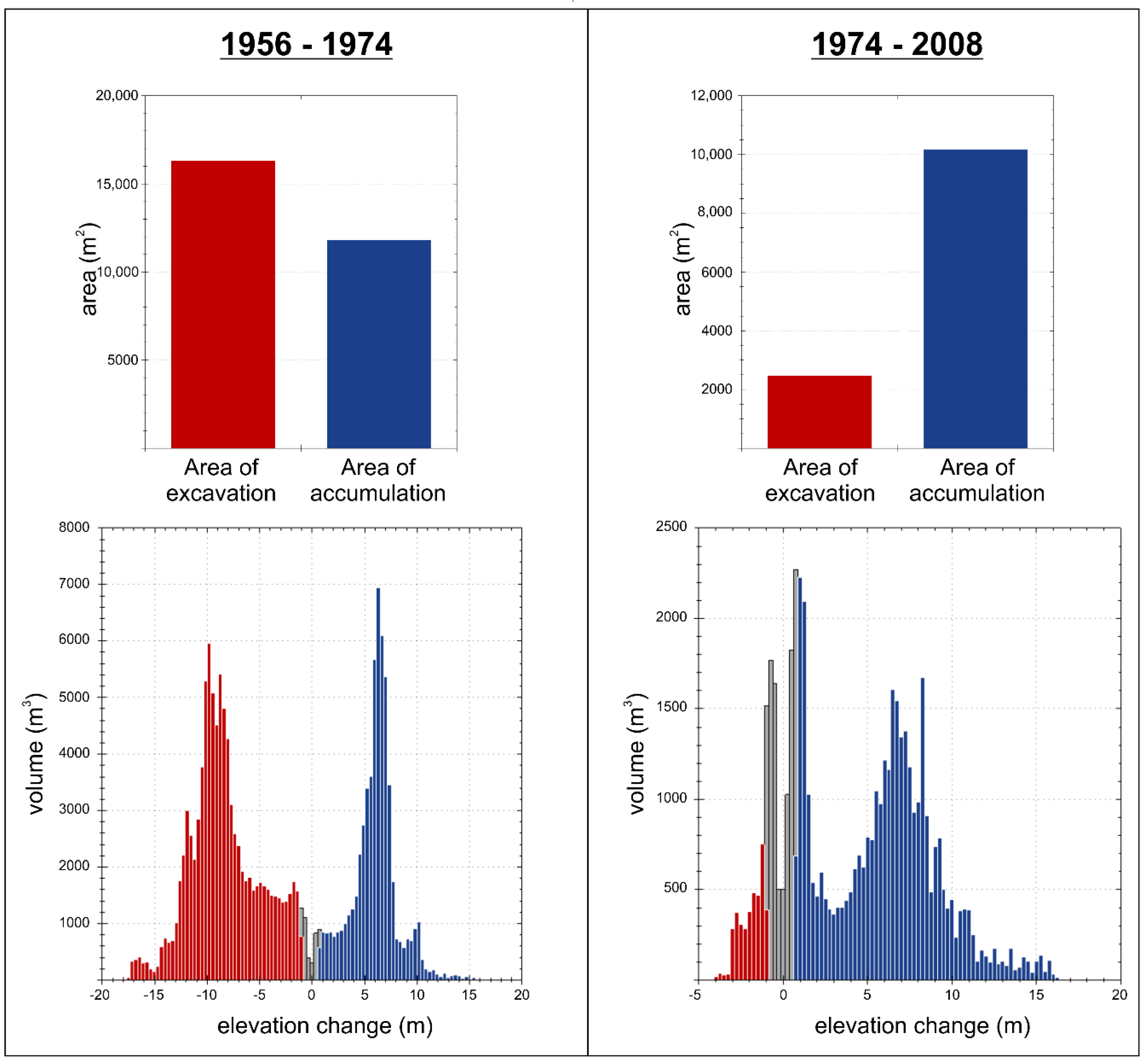
| Total area of excavation (m2) | 16,312 | 2472 |
| Total area of accumulation (m2) | 11,796 | 10,176 |
| Total volume of excavation (m3) | 94,394 ± 13,538 | 3848 ± 2298 |
| Total volume of accumulation (m3) | 58,687 ± 9790 | 37,032 ± 9463 |
| Average depth of excavation (m) | −5.8 ± 0.8 | −1.5 ± 0.9 |
| Average depth of accumulation (m) | 5 ± 0.8 | 3.6 ± 0.9 |
| Percent by volume of excavation (%) | 62 | 10 |
| Percent by volume of accumulation (%) | 38 | 90 |
© 2018 by the authors. Licensee MDPI, Basel, Switzerland. This article is an open access article distributed under the terms and conditions of the Creative Commons Attribution (CC BY) license (http://creativecommons.org/licenses/by/4.0/).
Share and Cite
Esposito, G.; Matano, F.; Sacchi, M. Detection and Geometrical Characterization of a Buried Landfill Site by Integrating Land Use Historical Analysis, Digital Photogrammetry and Airborne Lidar Data. Geosciences 2018, 8, 348. https://doi.org/10.3390/geosciences8090348
Esposito G, Matano F, Sacchi M. Detection and Geometrical Characterization of a Buried Landfill Site by Integrating Land Use Historical Analysis, Digital Photogrammetry and Airborne Lidar Data. Geosciences. 2018; 8(9):348. https://doi.org/10.3390/geosciences8090348
Chicago/Turabian StyleEsposito, Giuseppe, Fabio Matano, and Marco Sacchi. 2018. "Detection and Geometrical Characterization of a Buried Landfill Site by Integrating Land Use Historical Analysis, Digital Photogrammetry and Airborne Lidar Data" Geosciences 8, no. 9: 348. https://doi.org/10.3390/geosciences8090348
APA StyleEsposito, G., Matano, F., & Sacchi, M. (2018). Detection and Geometrical Characterization of a Buried Landfill Site by Integrating Land Use Historical Analysis, Digital Photogrammetry and Airborne Lidar Data. Geosciences, 8(9), 348. https://doi.org/10.3390/geosciences8090348


