Paleo-Drainage Network, Morphotectonics, and Fluvial Terraces: Clues from the Verde Stream in the Middle Sangro River (Central Italy)


Abstract
1. Introduction
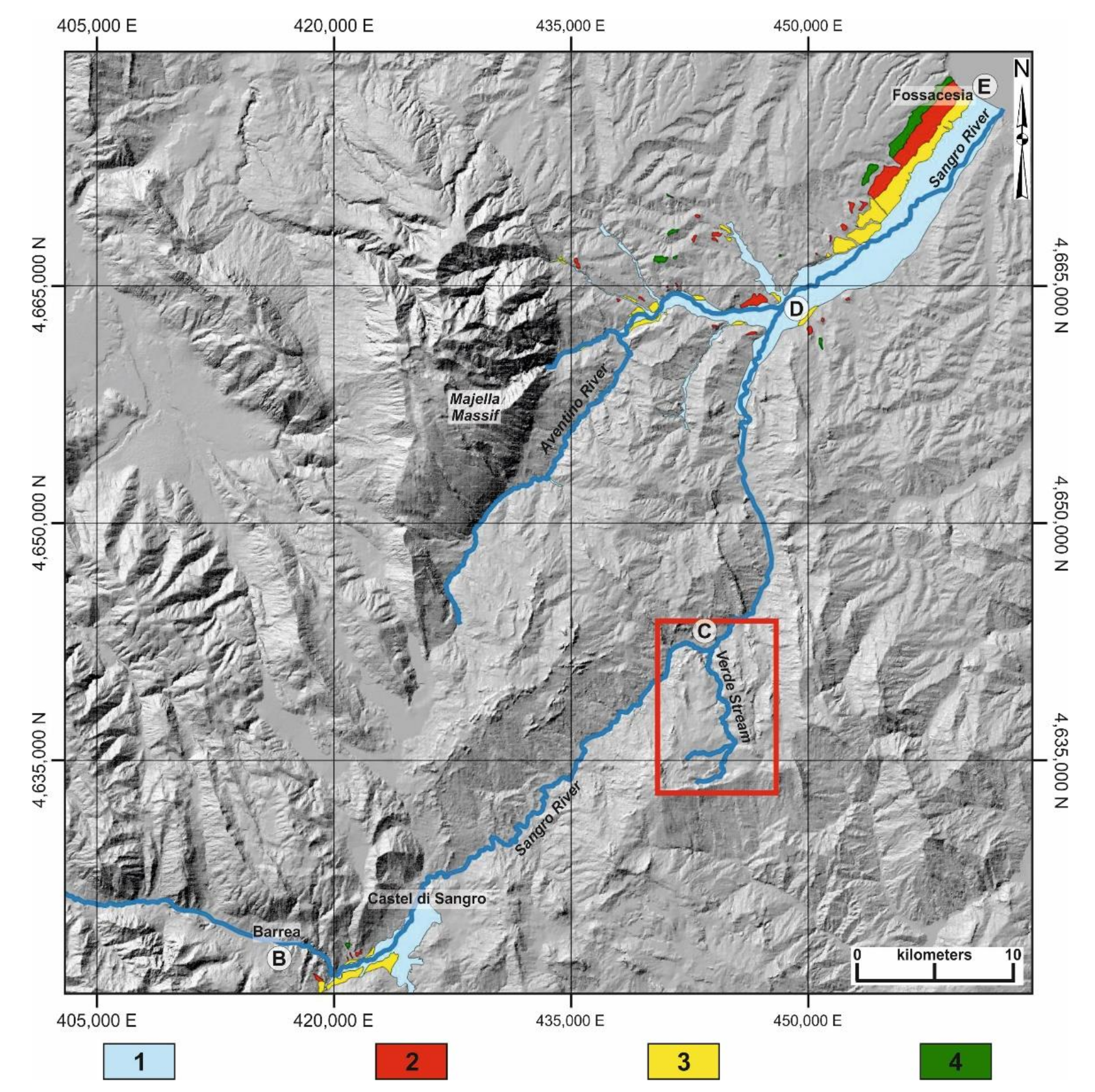
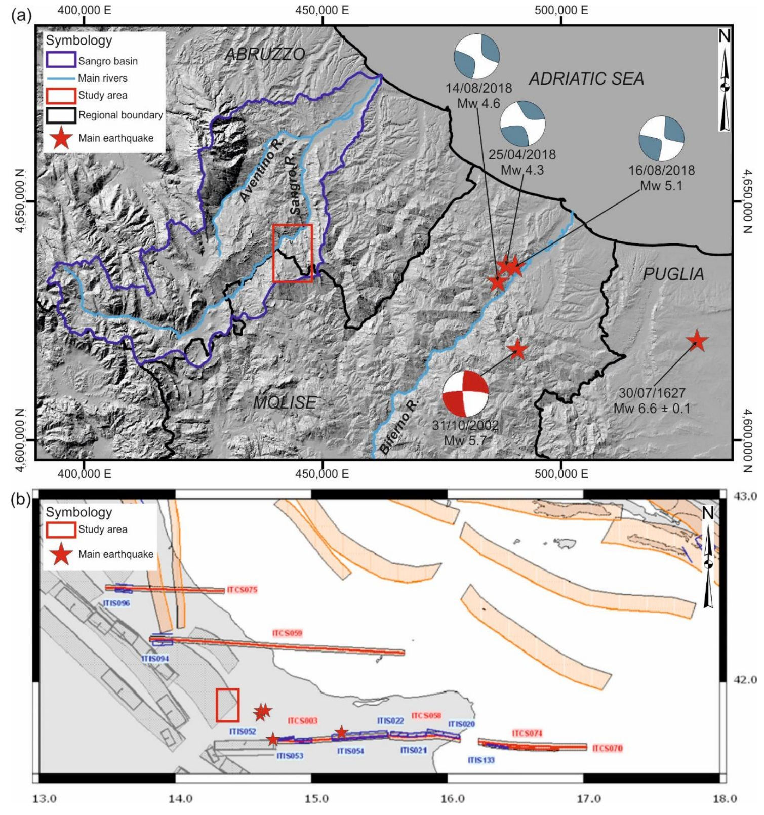
2. Study Area
2.1. Regional Geological and Geomorphological Setting
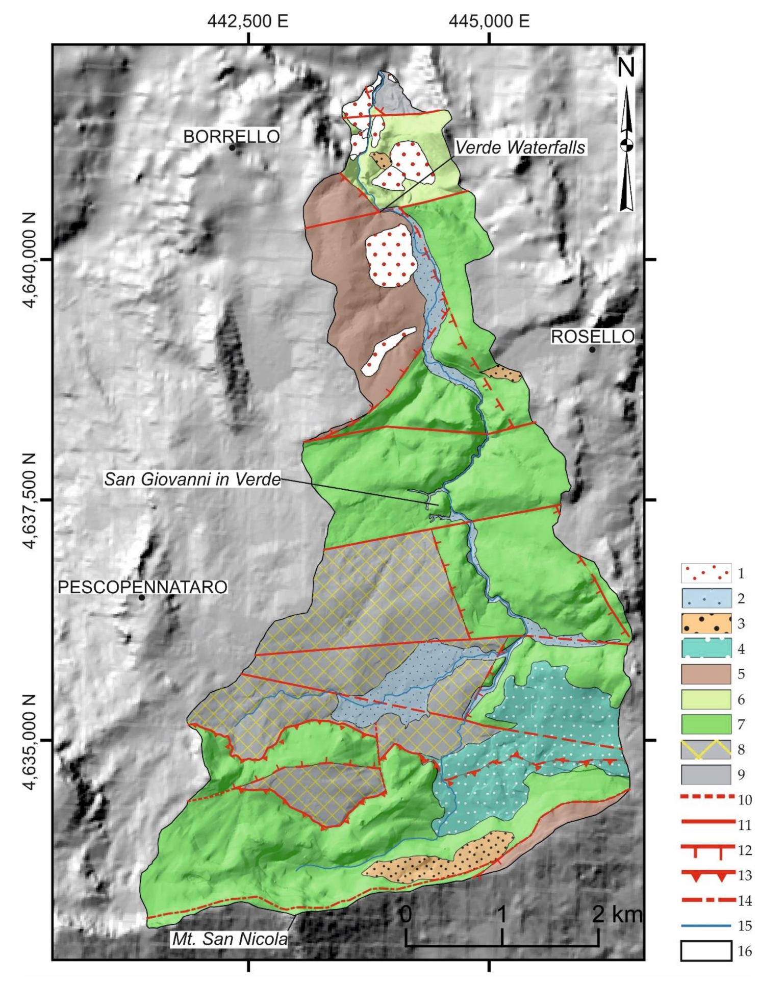
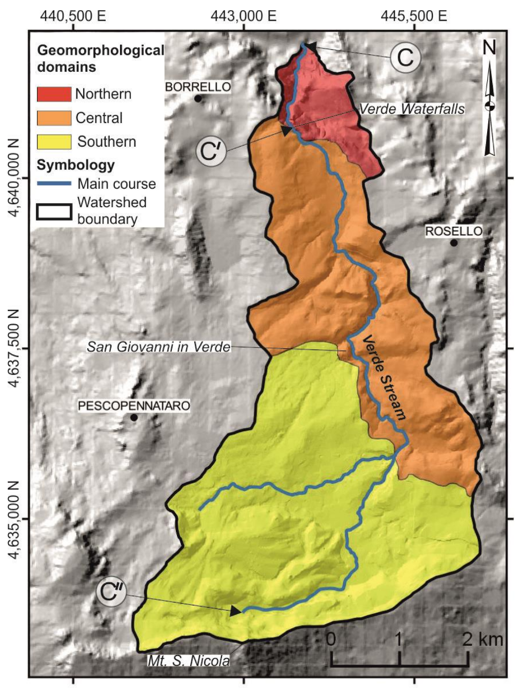
2.2. Geological Setting of the Verde Stream Catchment Area
3. Methods
4. Results
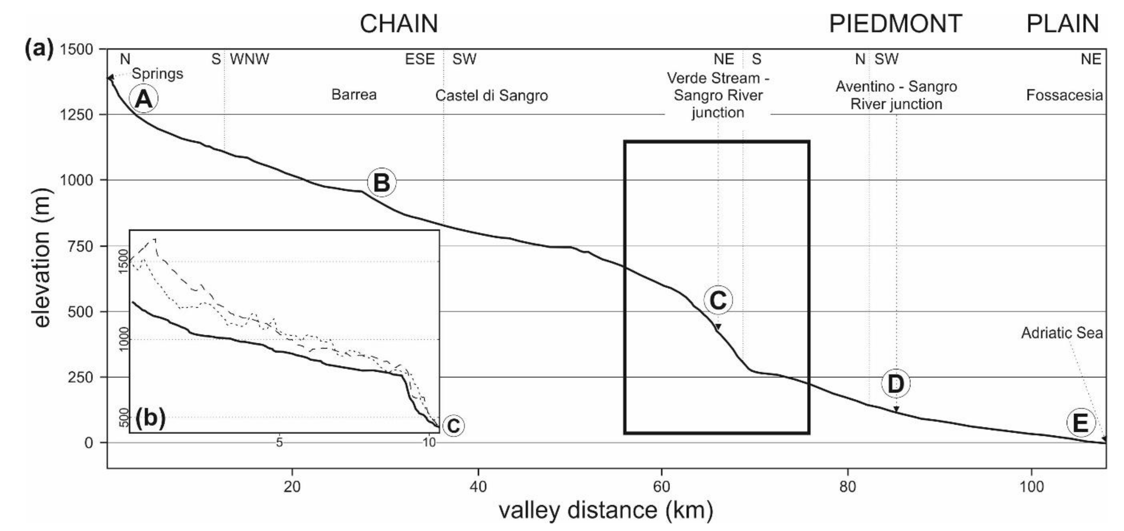
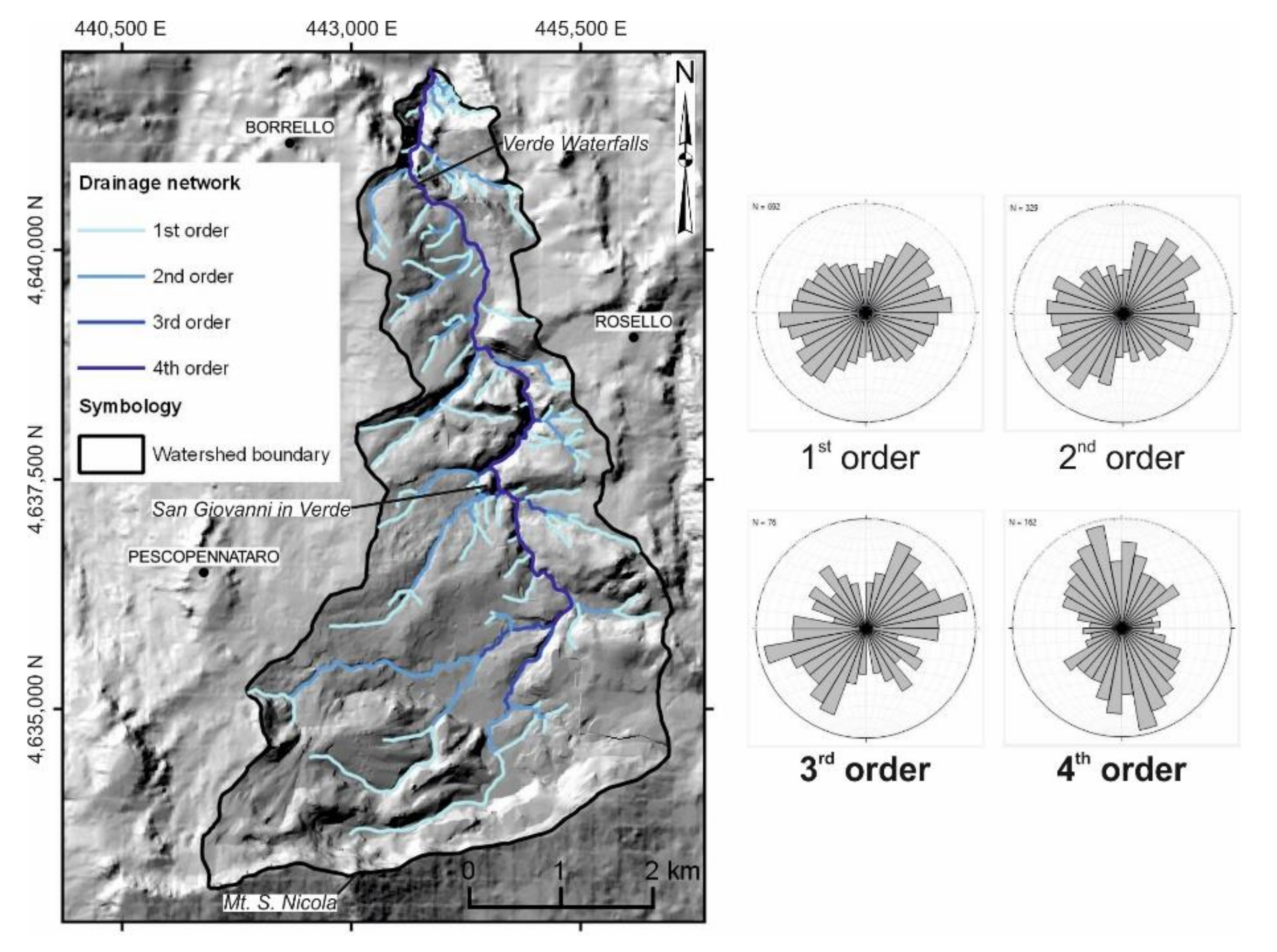
4.1. Orography and Hydrography
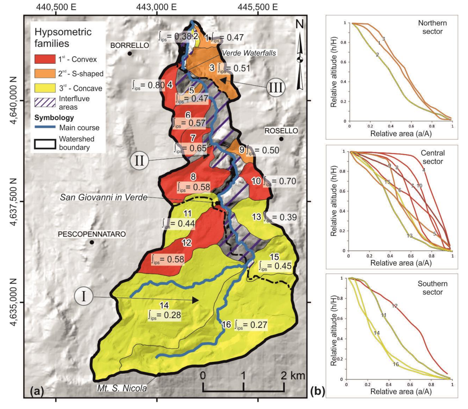
4.2. Hypsometric Curves and Integral
4.3. Erosion Index
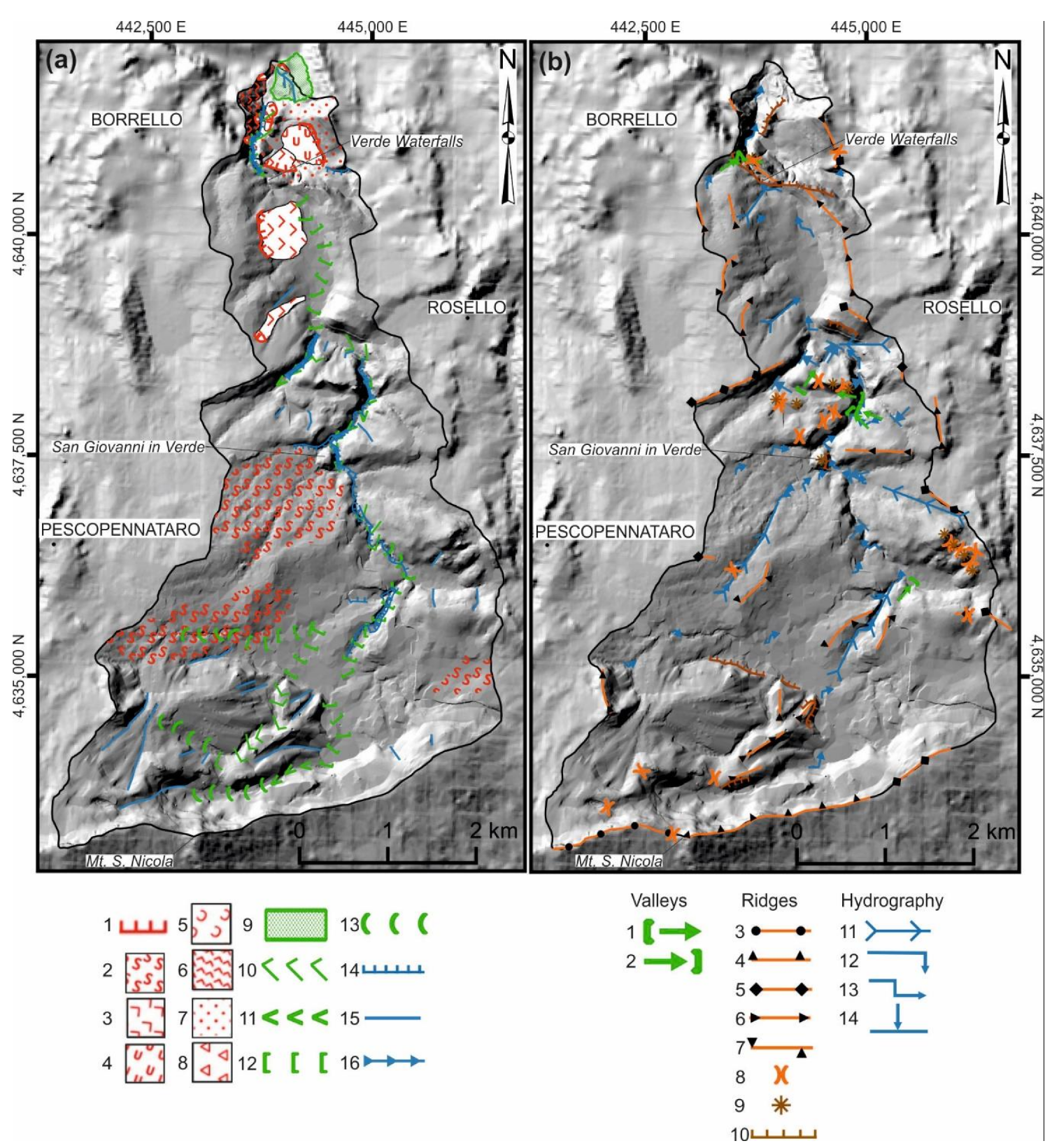
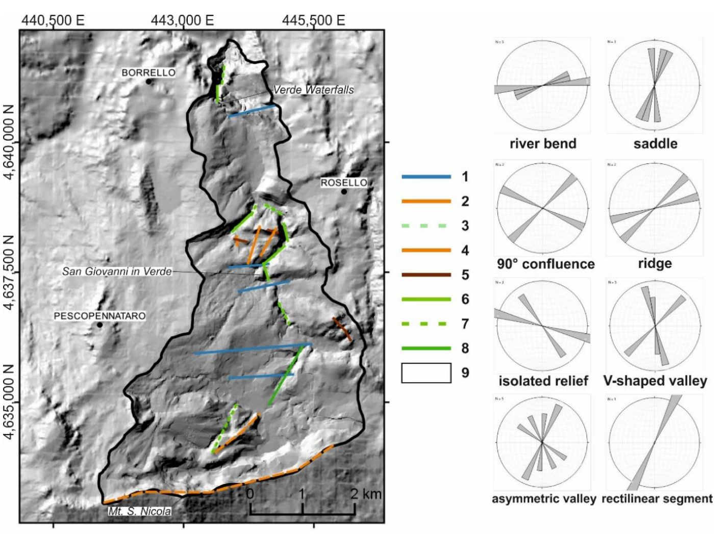
4.4. Geomorphological Analysis
5. Discussion
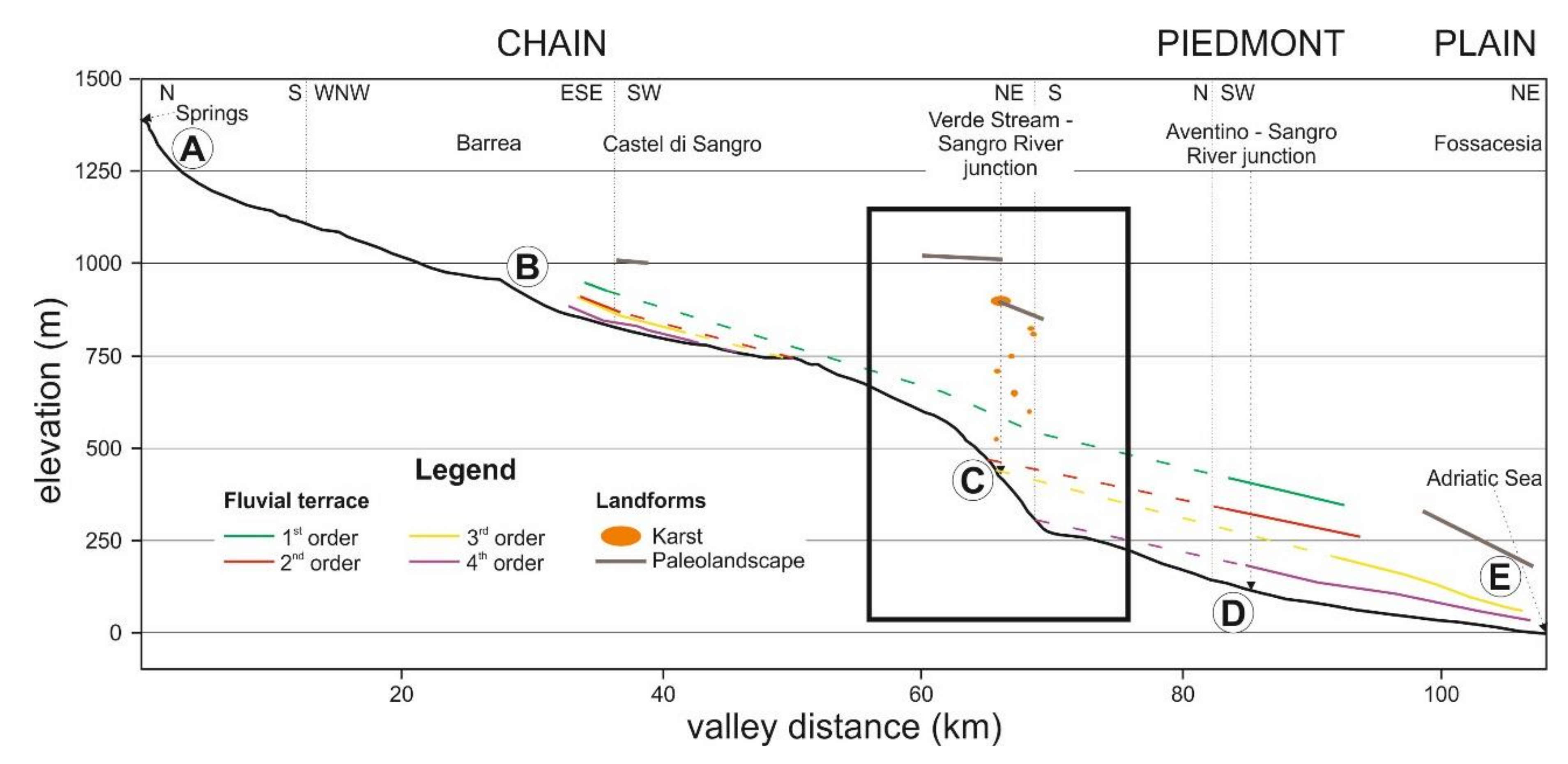
5.1. Morphometric Features
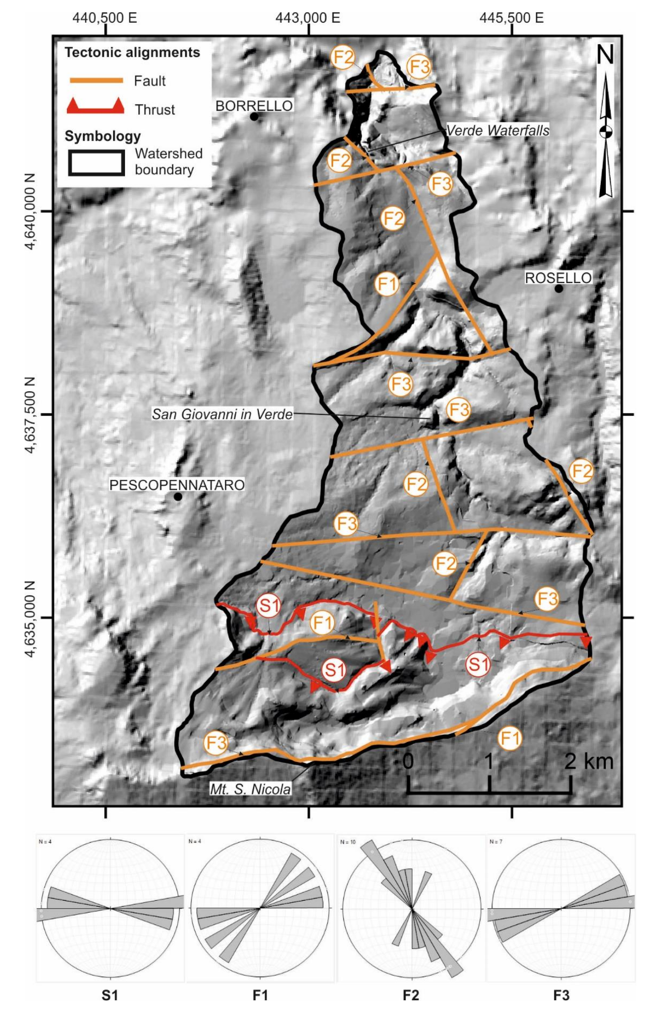
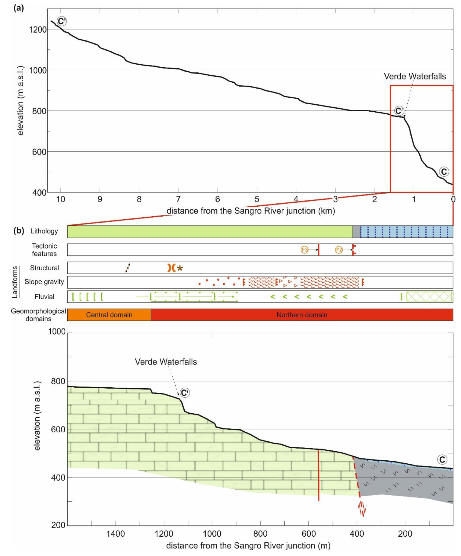
5.2. Morphotectonic Features
- S1: interpreted as a thrust with E–W trend;
- F1: oriented NE–SW;
- F2: with a trend variable from NNW–SSE to NNE–SSW;
- F3: oriented in the E–W and ENE–WSW direction.
5.3. Geomorphological Domains
- the development of landforms and processes due to the drainage network incision, resulting from a combination of both areal denudation (badland area) and linear downcutting (V-shaped valley, widely present in the central geomorphological domain);
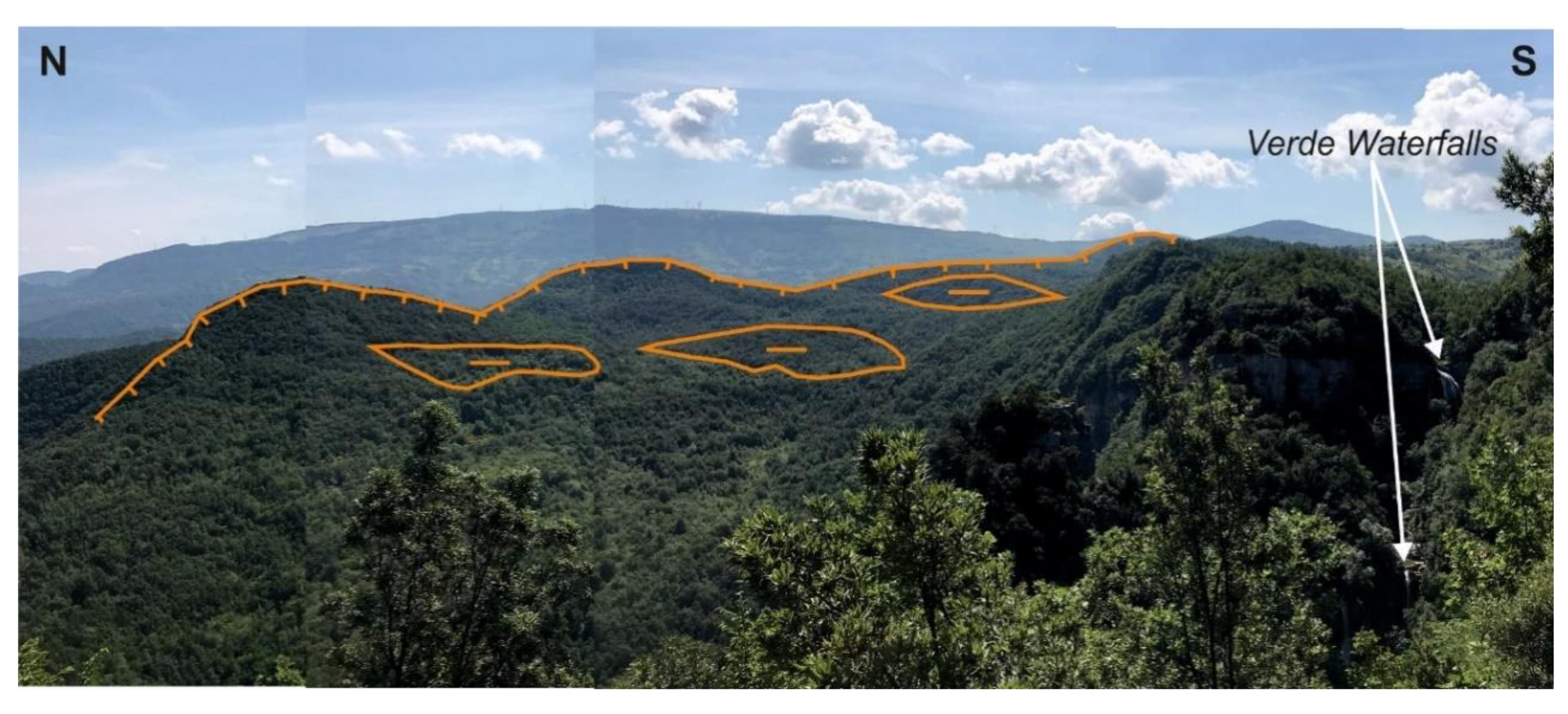
- the development of slope processes and landforms due to slope gravity areal denudation, widely present in the northern geomorphological domain near the Verde Waterfalls.
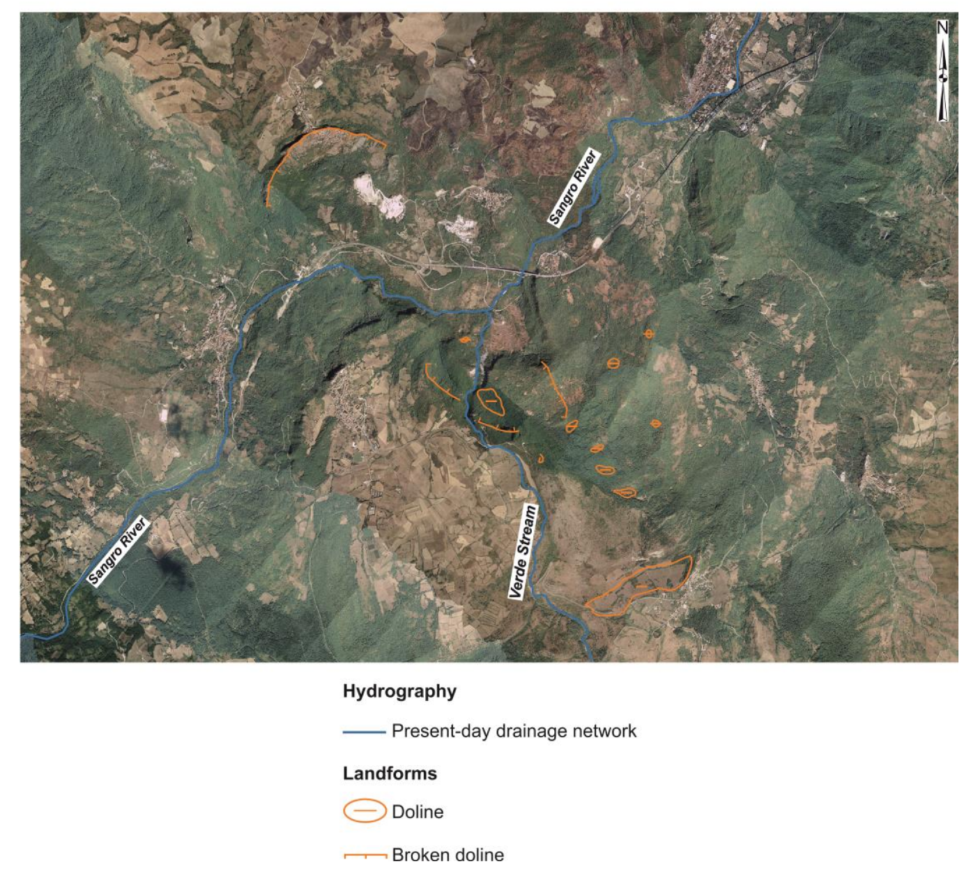
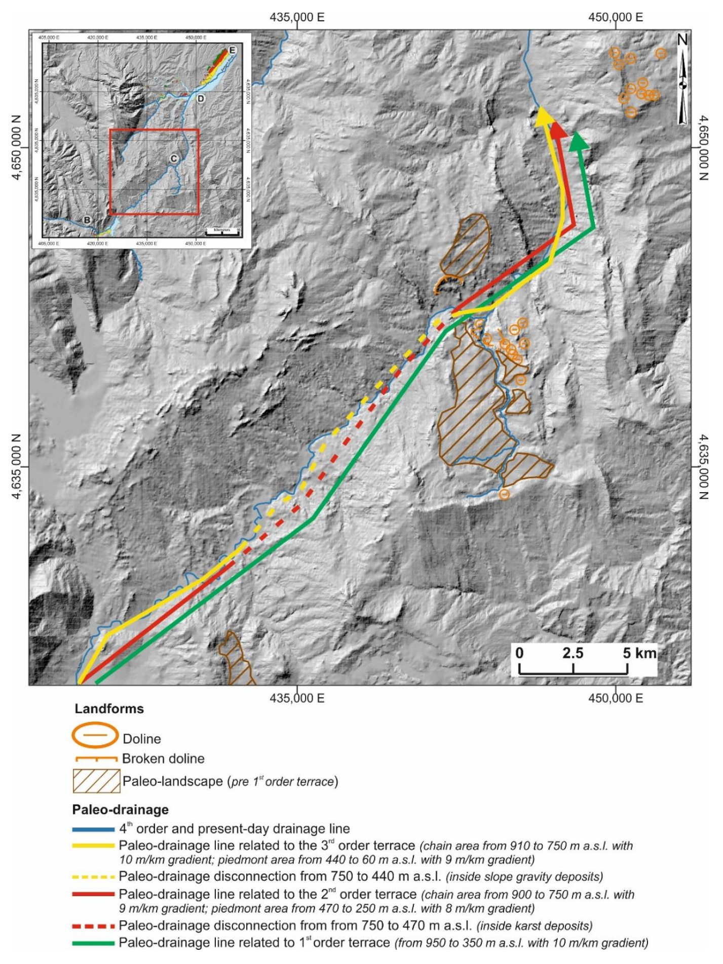
5.4. Karst Features and Paleo-Landscapes
6. Conclusions
- an initial paleo-landscape, with widespread karst landforms, plotted above the first order terrace’s projection, aged at least pre-Middle Pleistocene; this landscape is affected by NE–SW and NNW–SSE/NNE–SSW tectonic features (F1–F2);
- dissection of the hanging karst paleo-landscape (as testified by hanging and broken dolines and karst landforms) and development of a paleo-drainage level linked to the projection of first order terraces (Middle Pleistocene); this is driven by uplift and possibly by E–W tectonic features (F3);
- further progressive incision of the middle Sangro valley across the transition zone between Apennines chain and piedmont; creation of the abrupt knick convex zone of the Sangro valley and dissection of the northern sector of the Verde Stream due to karst landscape dissection and slope gravity-induced processes; development of a paleo-drainage level related to second and third order terraces (late Middle Pleistocene–Late Pleistocene) disconnected in the middle Sangro valley due to karst underground drainage and possibly landslide by paleo-landslide and karst deposits.
Author Contributions
Funding
Acknowledgments
Conflicts of Interest
References
- D’Alessandro, L.; Miccadei, E.; Piacentini, T. Morphostructural elements of central-eastern Abruzzi: Contributions to the study of the role of tectonics on the morphogenesis of the Apennine chain. Quat. Int. 2003, 101–102, 115–124. [Google Scholar] [CrossRef]
- D’Alessandro, L.; Miccadei, E.; Piacentini, T. Morphotectonic study of the lower Sangro River valley (Abruzzi, Central Italy). Geomorphology 2008, 102, 145–158. [Google Scholar] [CrossRef]
- Miccadei, E.; Piacentini, T.; Dal Pozzo, A.; La Corte, M.; Sciarra, M. Morphotectonic map of the Aventino-Lower Sangro valley (Abruzzo, Italy), scale 1:50,000. J. Maps 2013, 9, 390–409. [Google Scholar] [CrossRef]
- Artoni, A. The Pliocene-Pleistocene stratigraphic and tectonic evolution of the Central sector of the Western Periadriatic Basin of Italy. Mar. Pet. Geol. 2013, 42, 82–106. [Google Scholar] [CrossRef]
- Di Bucci, D.; Angeloni, P. Adria Seismicity and sismotectonics: Review and critical discussion. Mar. Pet. Geol. 2013, 42, 182–190. [Google Scholar] [CrossRef]
- Kastelic, V.; Vannoli, P.; Burrato, P.; Fracassi, U.; Tiberti, M.M.; Valenzise, G. Seismogenic sources in the Adriatic Domain. Mar. Pet. Geol. 2013, 42, 191–213. [Google Scholar] [CrossRef]
- Rovida, A.; Locati, M.; Camassi, R.; Lolli, B.; Gasperini, P. CPTI15—2015 Version of the Parametric Catalogue of Italian Earthquakes; INGV: Rome, Italy, 2016. [Google Scholar]
- Gasparini, C.; Conte, S.; Vannucci, C. Bollettino Macrosismico 2001–2005; [CD-ROM]; INGV: Rome, Italy, 2011. [Google Scholar]
- D’Agostino, N.; Jackson, J.A.; Dramis, F.; Funiciello, R. Interactions between mantle upwelling, drainage evolution and active normal faulting: An example from central Apennines (Italy). Geophys. J. Int. 2001, 141, 475–497. [Google Scholar] [CrossRef]
- Pizzi, A. Plio-Quaternary uplift rates in the outer zone of the central Apennines fold-and-thrust belt, Italy. Quat. Int. 2003, 101–102, 229–237. [Google Scholar] [CrossRef]
- Ascione, A.; Cinque, A.; Miccadei, E.; Villani, F.; Berti, C. The Plio-Quaternary uplift of the Apennine chain: New data from the analysis of topography and river valleys in Central Italy. Geomorphology 2008, 101–102, 105–108. [Google Scholar] [CrossRef]
- Piacentini, T.; Miccadei, E. The role of drainage systems and intermontane basins in the Quaternary landscape of the Central Apennines chain (Italy). Rend. Lincei-Sci. Fis. Nat. 2014, 25, 139–150. [Google Scholar] [CrossRef]
- Della Seta, M.; Del Monte, M.; Fredi, P.; Miccadei, E.; Nesci, O.; Pambianchi, G.; Piacentini, T.; Troiani, F. Morphotectonic evolution of the Adriatic piedmont of the Apennines: An advancement in the knowledge of the Marche-Abruzzo border area. Geomorphology 2008, 102, 119–129. [Google Scholar] [CrossRef]
- Bracone, V.; Amorosi, A.; Aucelli, P.P.C.; Rosskopf, C.M.; Scarciglia, F.; Di Donato, V.; Esposito, P. The Pleistocene tectonosedimentary evolution of the Apenninic foreland basin between Trigno and Fortore rivers (Southern Italy) through a sequence stratigraphic perspective. Basin Res. 2012, 24, 213–233. [Google Scholar] [CrossRef]
- Aucelli, P.P.C.; Faillace, P.I.; Rosskopf, C.M. Evoluzione geomorfologica del tratto finale del fondovalle del fiume Biferno (Molise) dal 1800 ad oggi. Boll. Soc. Geog. Ital. 2009, 87, 367–378. [Google Scholar]
- Aucelli, P.P.C.; Cinque, A.; Rosskopf, C. Geomorphologic map of the Trigno basin (Italy): Explanatory notes. Geogr. Fis. Din. Quat. 2001, 24, 3–12. [Google Scholar]
- Nesci, O.; Savelli, D. Diverging drainage in the Marche Apennines (central Italy). Quat. Int. 2003, 101–102, 203–209. [Google Scholar] [CrossRef]
- Pazzaglia, F.J.; Brandon, M.T. A fluvial record of long-term steady-state uplift and erosion across the Cascadia forearc high, Western Washington State. Am. J. Sci. 2001, 301, 385–431. [Google Scholar] [CrossRef]
- Giaconia, F.; Booth-Rea, G.; Martínez-Martínez, J.M.; Azañón, J.M.; Pérez-Peña, J.V. Geomorphic analysis of the Sierra Cabrera, an active pop-up in the constrictional domain of conjugate strike-slip faults: The Palomares and Polopos fault zones (eastern Betics, SE Spain). Tectonophysics 2012, 580, 27–42. [Google Scholar] [CrossRef]
- Giaconia, F.; Booth-Rea, G.; Martínez-Martínez, J.M.; Azañón, J.M.; Pérez-Peña, J.V.; Pérez-Romero, J.; Villegas, I. Geomorphic evidence of active tectonics in the Sierra Alhamilla (eastern Betics, SE Spain). Geomorphology 2012, 145, 90–106. [Google Scholar] [CrossRef]
- Ferrater, M.; Booth-Rea, G.; Pérez-Peña, J.V.; Azañón, J.M.; Giaconia, F.; Masana, E. From extension to transpression: Quaternary reorganization of an extensional-related drainage network by the Alhama de Murcia strike-slip fault (eastern Betics). Tectonophysics 2015, 663, 33–47. [Google Scholar] [CrossRef]
- Molin, P.; Fubelli, G. Morphometric evidence of the topographic growth of central Apennines. Geog. Fis. Din. Quat. 2005, 28, 47–61. [Google Scholar]
- Clermonté, J. Une contribution a l’étude géologique des formations molisanes du basin de Sangro (Italie centro-méridionale). Boll. Soc. Geol. 1969, 7, 830–840. [Google Scholar] [CrossRef]
- Patacca, E.; Scandone, P. Geology of the Southern Apennines. Boll. Soc. Geol. Ital. 2007, 7, 75–119. [Google Scholar]
- Ghisetti, F.; Vezzani, L.; Festa, A. Note Illustrative Della Carta Geologica del Molise (Campobasso, Italy), Scala 1:100,000; Litografia Geda: Nichelino, Italy, 2004. [Google Scholar]
- Di Bucci, D. Rapporti tra piattaforme carbonatiche e «Alloctono» lungo la media valle del Sangro. Mem. Soc. Geol. Ital. 1995, 11, 443–463. [Google Scholar]
- Di Bucci, D. Carta Geologica dei Rilievi Circostanti la Media Valle del F. Sangro: La zona di M. Campo e la Struttura Pizzoferrato-Castel di Sangro; Dipartimento di Scienze Geologiche: Rome, Italy, 1995. [Google Scholar]
- Corrado, S.; Di Bucci, D.; Naso, G.; Butler, R.W.H. Thrusting and strike-slip tectonics in Alto Molise region (Italy): Implications for the Neogene-Quaternary evolution of the Central Apennine orogenic system. J. Geol. Soc. Lond. 1997, 154, 679–688. [Google Scholar] [CrossRef]
- Corrado, S.; Di Bucci, D.; Naso, G.; Damiani, A.V. Rapporti tra le grandi unità stratigrafico-strutturali dell’Alto Molise (Appennino centrale). Boll. Soc. Geol. Ital. 1998, 117, 761–776. [Google Scholar]
- Galadini, F.; Messina, P. Characterization of the recent tectonics of the Upper Sangro River Valley (Abruzzi Apennine, Central Italy). Ann. Geofis. 1993, 36, 277–285. [Google Scholar]
- Di Bucci, D.; Tozzi, M. La “linea Ortona-Roccamonfina”: Revisione dei dati esistenti e nuovi contributi per il settore settentrionale (media Valle del Sangro). Studi Geol. Camerti 1992, 2, 397–406. [Google Scholar]
- Patacca, E.; Scandone, P.; Bellatalla, M.; Perilli, N.; Santini, U. La zona di giunzione tra l’arco appenninico settentrionale e l’arco appenninico meridionale nell’Abruzzo e nel Molise. Studi Geol. Camerti 1991, 2, 417–441. [Google Scholar]
- Patacca, E.; Scandone, P.; Di Luzio, E.; Cavinato, G.P.; Parotto, M. Structural architecture of the central Apennines: Interpretation of the CROP 11 seismic profile from the Adriatic coast to the orographic divide. Tectonics 2008, 27. [Google Scholar] [CrossRef]
- Capelli, G.; Miccadei, E.; Raffi, R. Fluvial dynamics in the Castel di Sangro plain: Morphological changes and human impact from 1875 to 1992. Catena 1997, 30, 295–309. [Google Scholar] [CrossRef]
- Aucelli, P.P.C.; Cavinato, G.P.; Cinque, A. Geomorphological evidence of Pliocene-Quaternary tectonics in the Adriatic piedmont of the Abruzzi Apennines. Il Quat.-Ital. J. Quat. Sci. 1996, 9, 299–302. [Google Scholar]
- Demangeot, J. Geomorphologie des Abruzzes Adriatiques; Edition du Centre National de la Recherche Scientifique (Paris): Paris, France, 1965; pp. 1–403. [Google Scholar]
- Ascione, A.; Miccadei, E.; Villani, F.; Berti, C. Morphostructural setting of the Sangro and Volturno rivers divide area (Central-Southern Apennines, Italy). Geogr. Fis. Dinam. Quat. 2007, 30, 13–29. [Google Scholar]
- Currado, C.; Fredi, P. Morphometric parameters of drainage basins and morphotectonic setting of western Abruzzo. Mem. Soc. Geol. Ital. 2000, 55, 411–419. [Google Scholar]
- Ciccacci, S.; D’Alessandro, L.; Dramis, F.; Miccadei, E. Geomorphologic Evolution and Neotectonics of the Sulmona Intramontane Basin (Abruzzi, Apennine, Central Italy). Z. Geomorphol. 1999, 118, 27–40. [Google Scholar]
- Miccadei, E.; Piacentini, T.; Esposito, G.; Berti, C.; Mancinelli, V. Morphotectonic map of the Tasso Stream-Sagittario River valley (Central Apennines, Italy). J. Maps. under review.
- Mayer, L.; Menichetti, M.; Nesci, O.; Savelli, D. Morphotectonic approach to the drainage analysis in the North Marche region, central Italy. Quat. Int. 2003, 101–102, 157–167. [Google Scholar] [CrossRef]
- Spagnolo, M.; Pazzaglia, F.J. Testing the geological influences on the evolution of river profiles: A case from northern Apennines (Italy). Geogr. Fis. Dinam. Quat. 2005, 28, 103–113. [Google Scholar]
- Miccadei, E.; Piacentini, T.; Buccolini, M. Long-term geomorphological evolution in the Abruzzo area, Central Italy: Twenty years of research. Geol. Carpathica 2017, 68, 19–28. [Google Scholar] [CrossRef]
- Patacca, E.; Scandone, P.; Sartori, R. Tyrrhenian basin and Apenninic arcs: Kinematic relations since Late Tortonian times. Mem. Soc. Geol. Ital. 1990, 45, 425–451. [Google Scholar]
- Parotto, M.; Praturlon, A. The Southern Apennine arc. In Geology of Italy; Crescenti, U., D’Offizi, S., Merlino, S., Sacchi, L., Eds.; Italian Geological Society: Rome, Italy, 2004; pp. 33–58. [Google Scholar]
- Vezzani, L.; Festa, A.; Ghisetti, F.C. Geology and tectonic evolution of the Central-Southern Apennines, Italy. Geol. Soc. Am. 2010, 469, 1–58. [Google Scholar]
- Ascione, A.; Cinque, A. Tectonics and erosion in the long term relief history of the Southern Apennines (Italy). Z. Geomorphol. Suppl. 1999, 118, 1–16. [Google Scholar]
- Nesci, O.; Savelli, D.; Troiani, F. Types and development of stream terraces in the Marche Apennines (Central Italy): A review and remarks on recent appraisals. Geomorphol. Relief Process. Environ. 2012, 2, 215–238. [Google Scholar] [CrossRef]
- Calista, M.; Miccadei, E.; Pasculli, A.; Piacentini, T.; Sciarra, M.; Sciarra, N. Geomorphological features of the Montebello sul Sangro large landslide (Abruzzo, Central Italy). J. Maps 2016, 12, 882–891. [Google Scholar] [CrossRef]
- Miccadei, E.; Mascioli, F.; Ricci, F.; Piacentini, T. Geomorphology of soft clastic rock coasts in the Mid Western Adriatic Sea (Abruzzo, Italy). Geomorphology. accepted.
- Devoti, R.; D’Agostino, N.; Serpelloni, E.; Pietrantonio, G.; Riguzzi, F.; Avallone, A.; Cavaliere, A.; Cheloni, D.; Cecere, G.; D’Ambrosio, C.; et al. A combined velocity field of the mediterranean region. Ann. Geophys. 2017, 60, 0215. [Google Scholar] [CrossRef]
- Chiaraluce, L.; Di Stefano, R.; Tinti, E.; Scognamiglio, L.; Michele, M.; Casarotti, E.; Cattaneo, M.; De Gori, P.; Chiarabba, C.; Monachesi, G.; et al. The 2016 central Italy seismic sequence: A first look at the mainshocks, aftershocks, and source models. Seismol. Res. Lett. 2017, 88, 757–771. [Google Scholar] [CrossRef]
- ISIDe Working Group, Version 1.0. Available online: http://cnt.rm.ingv.it/iside (accessed on 7 September 2018). [CrossRef]
- C Cruppo di Lavoro. Gruppo di Lavoro CPTI Catalogo Parametrico dei Terremoti Italiani. 2004 (CPTI04); INGV: Bologna, Italy, 2004. [Google Scholar]
- Locati, M.; Camassi, R.; Rovida, A.; Ercolani, E.; Bernardini, F.; Castelli, V.; Caracciolo, C.H.; Tertulliani, A.; Rossi, A.; Azzaro, R.; et al. DBMI15, The 2015 Version of the Italian Macroseismic Database; INGV: Rome, Italy, 2016. [Google Scholar]
- Elter, P.; Grasso, M.; Parotto, M.; Vezzani, L. Structural setting of the Apennine-Maghrebian thrust belt. Episodes 2003, 26, 205–211. [Google Scholar]
- Dramis, F. The role of long-range tectonic uplift in the genesis of the Apennine relief. Studi Geol. Camerti 1993, 1, 9–15. [Google Scholar]
- Nesci, O.; Savelli, D. Successioni alluvionali terrazzate nell’Appennino nordmarchigiano. Geog. Fis. Din. Quat. 1991, 14, 149–162. [Google Scholar]
- Nesci, O.; Savelli, D.; Veneri, F. Terrazzi vallivi e superfici di spianamento nell’evoluzione del rilievo appenninico nord-marchigiano. Studi Geol. Camerti 1992, 1, 175–180. [Google Scholar]
- Di Celma, C.; Farabollini, P.; Moscatelli, U. Landscape, settlement and roman cadastres in the lower Sangro valley (Italy). Geoarchaeol. Landsc. Class. Antiq. 2000, 5, 23–34. [Google Scholar]
- SGI. Geological Map of Italy, Scale 1:100,000, Sheet 161 “Isernia”; ISPRA: Rome, Italy, 1971. [Google Scholar]
- SGI. Geological Map of Italy, Scale 1:100,000, Sheet 153 “Agnone”; ISPRA: Rome, Italy, 1971. [Google Scholar]
- ISPRA. Geological Map of Italy, Scale 1:50,000, Sheet 372 “Vasto”; ISPRA: Rome, Italy, 2010. [Google Scholar]
- ISPRA. Geological Map of Italy, Scale 1:50,000, Sheet 393 “Trivento”; ISPRA: Rome, Italy, 2011. [Google Scholar]
- Allocca, V.; Celico, F.; De Vita, P.; Fabbrocino, S. Idrodinamica sotterranea in successioni carbonatiche in facies di bacino: L’area campione di Monte Campo (Molise, Italia meridionale). Ital. J. Eng. Geol. Environ. 2006, 2, 5–22. [Google Scholar]
- Strahler, A.N. Quantitative analysis of watershed geomorphology. Am. Geophys. Union Trans. 1957, 38, 913–920. [Google Scholar] [CrossRef]
- Avena, G.C.; Giuliano, G.; Lupia Palmieri, E. Sulla valutazione quantitativa della gerarchizzazione ed evoluzione dei reticoli fluviali. Boll. Soc. Geol. Ital. 1967, 86, 781–196. [Google Scholar]
- Strahler, A.N. Dynamic basis of geomorphology. Geol. Soc. Am. Bull. 1952, 63, 923–938. [Google Scholar] [CrossRef]
- Ciccacci, S.; D’Alessandro, L.; Fredi, P.; Lupia Palmieri, E. Relation between morphometric characteristics and denudational processes in some drainage basins of Italy. Z. Geomorphol. 1992, 36, 53–67. [Google Scholar]
- Wobus, C.; Whipple, K.; Kirby, E.; Snyder, N.; Johnson, J.; Spyropolou, K.; Sheehan, D. Tectonics from topography: Procedures, promise and pitfalls. Geol. Soc. Am. 2006, 398, 5–74. [Google Scholar]
- Burbank, D.W.; Anderson, R.S. Tectonic Geomorphology, 2nd ed.; Wiley-Blackwell: Hokken, NJ, USA, 2011. [Google Scholar]
- Ahnert, F. Local relief and height limits of mountain ranges. Am. J. Sci. 1984, 284, 1035–1055. [Google Scholar] [CrossRef]
- Ciccacci, S.; D’Alessandro, L.; Fredi, P.; Lupia Palmieri, E. Contributo dell’analisi geomorfica quantitativa allo studio dei processi di denudazione nel bacino idrografico del Torrente Paglia (Toscana meridionale—Lazio settentrionale). Suppl. Geogr. Fis. Dinam. Quat. 1988, 1, 171–188. [Google Scholar]
- Keller, E.A.; Printer, N. Active Tectonics: Earthquakes, Uplift, and Landscape, 2nd ed.; Prentice Hall: Old Tappan, NJ, USA, 2001. [Google Scholar]
- Pérez-Peña, J.V.; Azañón, J.M.; Azor, A. CalHypso: An ArcGIS extension to calculate hypsometric curves and their statistical moments. Applications to drainage basin analysis in SE Spain. Comput. Geosci. 2009, 35, 1214–1223. [Google Scholar] [CrossRef]
- Ciccacci, S.; Fredi, P.; Lupia Palmieri, E.; Pugliese, F. Contributo dell’analisi geomorfica quantitativa alla valutazione dell’entità dell’erosione nei bacini fluviali. Boll. Soc. Geol. Ital. 1980, 99, 455–516. [Google Scholar]
- Grauso, S. Carta dell’indice di erosione dell’alto bacino del Fiume Agri. Doc. Del Territ. 1994, 28–29, 46–53. [Google Scholar]
- Agnesi, V.; Cappadonia, C.; Conoscenti, C.; Di Maggio, C.; Marker, M.; Rotigliano, E. Valutazione dell’erosione del suolo nel bacino del Fiume San Leonardo (Sicilia Centro-Occidentale, Italia). In Proceedings of the Atti del Convegno Conclusivo del Progetto “Erosione idrica in Ambiente Mediterraneo: Valutazione Diretta e Indiretta in aree Sperimentali e Bacini idrografici”, Florence, Italy, 17 December 2004; pp. 13–27. [Google Scholar]
- Ciccacci, S.; Fredi, P.; Lupia Palmieri, E.; Salvini, F. An approach to the quantitative analysis of the relations between drainage pattern and fracture trend. Int. Geomorphol. 1986, 49–68. [Google Scholar]
- Belisario, F.; Del Monte, M.; Fredi, P.; Funiciello, R.; Lupia Palmieri, E.; Salvini, F. Azimuthal analysis of stream orientations to define regional tectonic lines. Z. Geomorphol. 1999, 118, 41–63. [Google Scholar]
- Lupia Palmieri, E.; Ciccacci, S.; Civitelli, G.; Corda, L.; D’Alessandro, L.; Del Monte, M.; Fredi, P.; Pugliese, F. Geomorfologia quantitativa e morfodinamica del territorio abruzzese—I-IL bacino idrografico del Fiume Sinello. Geogr. Fis. Din. Quat. 1995, 18, 31–46. [Google Scholar]
- Lupia Palmieri, E.; Centamore, E.; Ciccacci, S.; D’Alessandro, L.; Del Monte, M.; Fredi, P.; Pugliese, F. Geomorfologia quantitativa e morfodinamica del territorio abruzzese—II-IL bacino idrografico del Fiume Tordino. Geogr. Fis. Din. Quat. 1998, 21, 113–129. [Google Scholar]
- Lupia Palmieri, E.; Biasini, A.; Caputo, C.; Centamore, E.; Ciccacci, S.; Del Monte, M.; Fredi, P.; Pugliese, F. Geomorfologia quantitativa e morfodinamica del territorio abruzzese—III-IL Bacino del Fiume Saline. Geogr. Fis. Din. Quat. 2001, 24, 157–176. [Google Scholar]
- Centamore, E.; Ciccacci, S.; Del Monte, M.; Fredi, P.; Lupia Palmieri, E. Morphological and morphometric approach to the study of the structural arrangement of the North-Eastern Abruzzo (Central Italy). Geomorphology 1996, 16, 127–137. [Google Scholar] [CrossRef]
- Kusak, M.; Kropacek, J.; Vilimek, V.; Scillaci, C. Analysis of the influence of tectonics on the evolution of valley networks based on SRTM DEM, Jemma River basin, Ethiopia. Geogr. Fis. Dinam. Quat. 2016, 39, 37–50. [Google Scholar]
- Pellegrini, A.; Cura di, G.B.; Carton, A.; Castaldini, D.; Cavallin, A.; D’Alessandro, L.; Dramis, F.; Gentili, B.; Laureti, L.; Prestininzi, A.; Rodolfi, G. Proposta di legenda geomorfologica ad indirizzo applicativo. Geogr. Fis. Din. Quat. 1993, 16, 129–152. [Google Scholar]
- SGN. Guida al rilevamento della Carta geomorfologica d’Italia, 1:50,000. In Quaderni Serie III del Servizio Geologico Nazionale; Servizio Geologico d’Italia: Rome, Italy, 1994; p. 4. [Google Scholar]
- ISPRA. Guida alla rappresentazione cartografica della Carta geomorfologica d’Italia, 1:50,000. In Quaderni Serie III del Servizio Geologico Nazionale; Servizio Geologico d’Italia: Rome, Italy, 2007; p. 48. [Google Scholar]
- ISPRA. Aggiornamento ed integrazione delle linee guida della Carta geomorfologica d’Italia in scala 1:50,000. In Quaderni Serie III del Servizio Geologico Nazionale; Servizio Geologico d’Italia: Rome, Italy, 2018; p. 98. [Google Scholar]
- Miccadei, E.; Orrù, P.; Piacentini, T.; Mascioli, F.; Puliga, G. Geomorphological map of Tremiti Islands Archipelago (Puglia, Southern Adriatic Sea, Italy), scale 1:15,000. J. Maps 2012, 8, 74–87. [Google Scholar] [CrossRef]
- Piacentini, T.; Urbano, T.; Sciarra, M.; Schipani, I.; Miccadei, E. Geomorphology of the floodplain at the confluence of the Aventino and Sangro rivers (Abruzzo, Central Italy). J. Maps 2015, 12, 443–461. [Google Scholar] [CrossRef]
- Ambrosetti, P.; Bonadonna, F.P.; Bosi, C.; Carraro, F.; Cita, B.M.; Giglia, G.; Manetti, P.; Martinis, B.; Merlo, C.; Panizza, M.; et al. Proposta di un progetto operativo per l’elaborazione della carta neotettonica d’Italia. In Progetto Finalizzato Geodinamica; Rome, Italy, 1976; pp. 1–49. [Google Scholar]
- Miccadei, E.; Paron, P.; Piacentini, T. The SW escarpment of the Montagna del Morrone (Abruzzi, Central Italy): Geomorphology of a fault-generated mountain front. Geogr. Fis. Dinam. Quat. 2004, 27, 55–87. [Google Scholar]
- Miccadei, E.; Mascioli, F.; Piacentini, T. Quaternary geomorphological evolution of the Tremiti Islands (Puglia, Italy). Quat. Int. 2011, 232, 3–15. [Google Scholar] [CrossRef]
- Miccadei, E.; Piacentini, T.; Gerbasi, F.; Daverio, F. Morphotectonic map of the Osento River basin (Abruzzo, Italy), scale 1:30,000. J. Maps 2012, 8, 62–73. [Google Scholar] [CrossRef]
- ENEL. Elementi di Neotettonica del Territorio Italiano; ENEL–Aquater (Gruppo ENI): Rome, Italy, 1981; p. 94. [Google Scholar]
- Goldsworthy, M.; Jackson, J. Active normal fault evolution in Greece revealed by geomorphology and drainage patterns. J. Geol. Soc. Lond. 2000, 157, 967–981. [Google Scholar] [CrossRef]
- Gioia, D.; Schiattarella, M.; Mattei, M.; Nico, G. Quantitative morphotectonics of the Pliocene to Quaternary Auletta basin, southern Italy. Geomorphology 2011, 134, 326–343. [Google Scholar] [CrossRef]
- D’Alessandro, L.; Del Sordo, L.; Buccolini, M.; Miccadei, E.; Piacentini, T.; Urbani, A. Analisi del dissesto da frana in Abruzzo. In Il Progetto IFFI-Inventario dei Fenomeni Franosi in Italia: Metodologia e Risultati; Rapporto APAT: Rome, Italy, 2007; pp. 463–692. [Google Scholar]


| Geomorphological Domain | Orography (m a.s.l.) | Slope (%) | ʃips | Local Relief (m) | Slope Gravity Processes (Landforms) | Fluvial Processes (Landforms) |
|---|---|---|---|---|---|---|
| Southern | 1600–1000 | 55–210 0–20 | <0.45 | 2–18 0~300 | Slow down-slope movement (soil creep) | Limited river erosion (flat bottom and concave valleys) |
| Central | 1000–750 | 15–55 | 0.55 < ʃips < 0.80 | 60–180 | Slow down-slope movement (Soil creep) | Linear downcutting (V-shaped valleys) |
| Northern | 750–420 | > 100 | 0.45 < ʃips < 0.50 | 180–300 | Landslides (rockfalls, topples, DSGSD) | Areal erosion (badlands area); linear river erosion (gorge, waterfalls) |
© 2018 by the authors. Licensee MDPI, Basel, Switzerland. This article is an open access article distributed under the terms and conditions of the Creative Commons Attribution (CC BY) license (http://creativecommons.org/licenses/by/4.0/).
Share and Cite
Miccadei, E.; Carabella, C.; Paglia, G.; Piacentini, T. Paleo-Drainage Network, Morphotectonics, and Fluvial Terraces: Clues from the Verde Stream in the Middle Sangro River (Central Italy). Geosciences 2018, 8, 337. https://doi.org/10.3390/geosciences8090337
Miccadei E, Carabella C, Paglia G, Piacentini T. Paleo-Drainage Network, Morphotectonics, and Fluvial Terraces: Clues from the Verde Stream in the Middle Sangro River (Central Italy). Geosciences. 2018; 8(9):337. https://doi.org/10.3390/geosciences8090337
Chicago/Turabian StyleMiccadei, Enrico, Cristiano Carabella, Giorgio Paglia, and Tommaso Piacentini. 2018. "Paleo-Drainage Network, Morphotectonics, and Fluvial Terraces: Clues from the Verde Stream in the Middle Sangro River (Central Italy)" Geosciences 8, no. 9: 337. https://doi.org/10.3390/geosciences8090337
APA StyleMiccadei, E., Carabella, C., Paglia, G., & Piacentini, T. (2018). Paleo-Drainage Network, Morphotectonics, and Fluvial Terraces: Clues from the Verde Stream in the Middle Sangro River (Central Italy). Geosciences, 8(9), 337. https://doi.org/10.3390/geosciences8090337