Article

Assessing Flood Hazard at River Basin Scale with an Index-Based Approach: The Case of Mouriki, Greece

by
Olga Patrikaki
1,
Nerantzis Kazakis
2,
Ioannis Kougias
3,*,
Thomas Patsialis
4,
Nicolaos Theodossiou
4 and
Konstantinos Voudouris
2
1
Decentralized Administration of Macedonia-Thrace, Water Directorate, 55134 Thessaloniki, Greece
2
Laboratory of Engineering Geology and Hydrogeology, School of Geology, Aristotle University of Thessaloniki, 54124 Thessaloniki, Greece
3
European Commission, Joint Research Centre (JRC), Directorate for Energy, Transport and Climate, Energy Efficiency and Renewables Unit, Via E. Fermi 2749, 21027 Ispra, Italy
4
Division of Hydraulics and Environmental Engineering, Department of Civil Engineering, Aristotle University of Thessaloniki, 54124 Thessaloniki, Greece
*
Author to whom correspondence should be addressed.
Geosciences 2018, 8(2), 50; https://doi.org/10.3390/geosciences8020050
Submission received: 13 October 2017 / Revised: 31 January 2018 / Accepted: 31 January 2018 / Published: 3 February 2018
(This article belongs to the Special Issue Integrated Risk Analysis and Management of Floods)

Abstract

:
Defining flood-prone areas is particularly important for policy makers, in order to design mitigation strategies and implement flood risk management planning. The present research applies a multicriteria index method to assess flood hazard areas at a river basin scale, in a geographic information system (GIS) environment. The developed methodology has been applied for an area in northeastern Greece, by processing information of seven parameters: flow accumulation, distance from the drainage network, elevation, land use, rainfall intensity and geology. The method assigns a relative importance to each of the parameters for the occurrence and magnitude of flooding, and the relevant weight values are defined through an “analytical hierarchy process”. Subsequently, and according to the relative importance of each index, the spatial information is superimposed, resulting in a flood hazard map of the studied region, an area in northern Greece. The obtained results indicate flood-prone zones, with a very high flood hazard mainly occurring at the lowlands in the vicinity of the drainage network. The provided flood hazard map supports planning activities and mitigation plans that are crucial to protect both the agricultural activities and existing infrastructure from future flood events.

1. Introduction

Flood events affect numerous people in the world, approximately 170 million people per year [1]. They also affect crop production and infrastructure in cities and rural areas. Recent estimations show that the frequency of extreme floods is expected to increase by the year 2100 [2]. Factors influencing the genesis of floods are topography, high relief, extreme rainfall, vegetation cover, types of geological formations, hydrographic networks and human interventions [3].
In Greece, floods are a significant natural hazard; in recent decades, a number of flood events have been recorded jeopardizing existing infrastructure, agricultural land and citizens’ lives. Population growth, the development of settlements in remote areas and the general increase in built infrastructure have increased the potential impact of the flood hazard. Increasing urbanization trends puts additional pressure on the need to expand inhabited settlements and road infrastructure to areas that may be unsuitable because of high flood risk [4]. Furthermore, flood events may be accompanied by landslides, an additional hazard with potentially catastrophic impact on settlements and human lives. So far, a number of studies have focused on flood hazard mapping as a first step in order to estimate flood vulnerability [5,6,7,8].
All parts of a river basin are vulnerable to floods in different degree under different cases and situations, which make them unique. A flood hazard assessment is a useful tool for policy makers and local authorities in order to design protection measures in river basins. The main steps in flood risk management are the following [9]: flood planning mitigation measures (before flood), response measures (during flood) and recovery (after flood). Different methods and techniques have been applied, including simulation (e.g., HEC-RAS software package), index methods, statistical analysis and hybrid methods in a geographic information system (GIS) environment [10,11,12]. GIS is recognized as a powerful means to integrate and analyze data from different sources. Thus, flood risk mapping has been implemented for different scenarios of urban growth, simulating the consequences of alternative cases [13]. According to a report published by the Organisation for Economic Co-operation and Development (OECD) [14], deterministic approaches are used to assess disaster impacts of a given hazard scenario, whereas nondeterministic methods are used to obtain more refined estimates of hazard frequencies and damages. Thus, nondeterministic methods consider all possible scenarios, incorporating the inherent uncertainties due to the complexity of the phenomenon analyzed, its randomness or simply knowledge limitations. The present study aims at analyzing the occurrence of flooding in a specific area; floods being hazards of particularly complex nature, a nondeterministic method, such as the one applied in the present research, is appropriate.
Flood studies mainly use GIS spatial models, including a significant—and still increasing—number of proposed methods. Chapi et al. [15] proposed a new artificial intelligence (AI) model, called bagging-LMT, which is the combination of a bagging ensemble and logistic model tree. The method was applied in Haraz watershed in northern Iran. Remote sensing techniques in conjunction with GIS have been used in flood susceptibility assessments in the region of West Bengal in India [16]. Modern methods are based on ensembles of adaptive neuro-fuzzy inference systems and metaheuristic algorithms [17] as well as genetic algorithms and differential evolution [18]. Zhao et al. [19] used a random forest (RF) model in order to map flood susceptibility areas in the mountainous part of China. It is clear that the vast number of models including different numbers of parameters might be confusing. Hence, we have focused on the application of an existing method in a different environment and on a smaller scale (river basin).
The present work deals with the definition of flood hazard areas in a river basin of Greece, using an index method in a GIS environment. This method analyzes seven parameters: flow accumulation (F), rainfall intensity (I), geology (G), land use (U), slope (S), elevation (E) and distance from the drainage network (D). The aim is to define flood hazard zones, where mitigation and protection measures should be prioritized. The developed methodology has been presented in the authors’ previous work [11], which was developed aiming to provide flood hazard assessments and mapping at a regional scale. However, an integrated flood protection plan presupposes higher discretization of hazard maps so as to be economically affordable and describable in terms of environmental processes. Therefore, we have downscaled the application of the method in a river basin where flood hazard maps are not available.

2. Study Area

The flood hazard was assessed in the Perdikas river basin, an area of approximately 100 km 2 located to the north of the city of Kozani. The mean slope and altitude of the basin are 26.1% and 874.5 m, respectively. The mean annual temperature and precipitation are 11.2 °C and 636.5 mm. The mountainous part of the basin is covered by crystalline rocks such as gneiss and amphibolites; neogene and quaternary deposits cover the lowlands. The main aquifer system is developed in the alluvial formations with a mean thickness of 70 m, while the natural recharge of the aquifer is attributed to direct infiltration from the precipitation, percolation from streams and lateral inflows from the fractured rock aquifer of the crystalline basement rocks. The mountainous part of the basin is covered by mixed forest, while agricultural and livestock activities take place mainly in the lowlands [20]. Figure 1 shows the geological formation of the basin and the geographic location of the studied area.

3. Materials and Methods

Flood hazard areas in the Mouriki Basin have been assessed in the present study using the FIGUSED-S method. FIGUSED-S has been developed by the authors [11] and is an index-based model operating in a GIS environment. FIGUSED-S defines flood hazard areas and originally had a regional focus. It processes information of seven parameters, the initials of which create the name of the method: “FIGUSED”. The parameters, described in detail in the following text, are: flow accumulation (F), rainfall intensity (I), geology (G), land use (U), slope (S), elevation (E), and distance from the drainage network (D). The morphological, meteorological, geological and hydrogeological data was collected by the authors in terms of a detailed analysis of the studied area [21]. The obtained information was subsequently verified, corrected and harmonized according to the purposes of the present exercise.

3.1. Flow Accumulation (F)

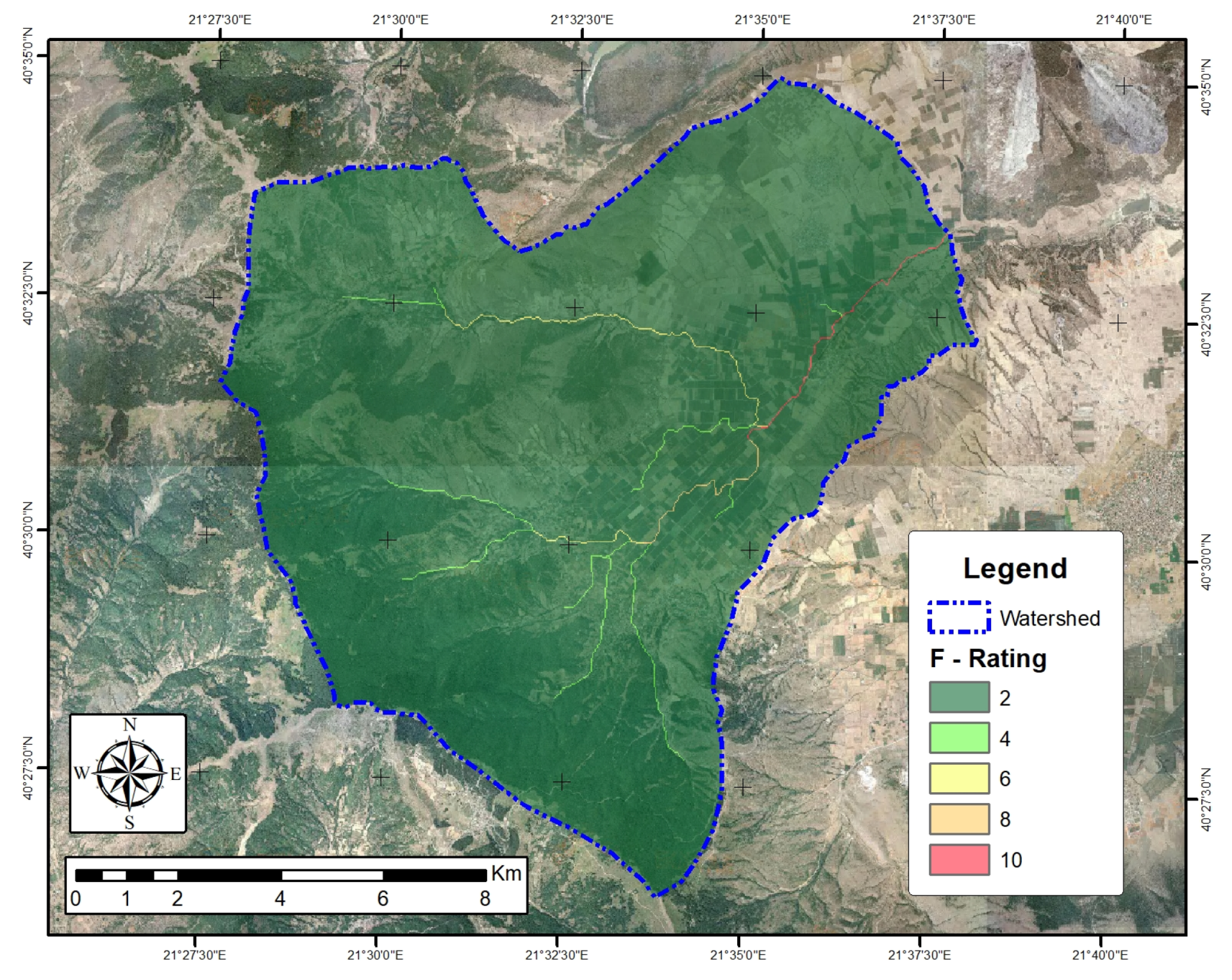
The method estimates the accumulated flow, an important criterion of flood occurrence. It does so by aggregating water flows from uphill to lower elevation at the output raster. High values of accumulated flow indicate cells in which the flowing water tends to concentrate. Such areas are more prone to the flood hazard. As indicated in Table 1, flow accumulation values are in the range 0–212,049. Figure 2 shows the distribution of the flow accumulation index in the studied region, with the high values only occurring in the tributaries and their outflows.

3.2. Rainfall Intensity (I)

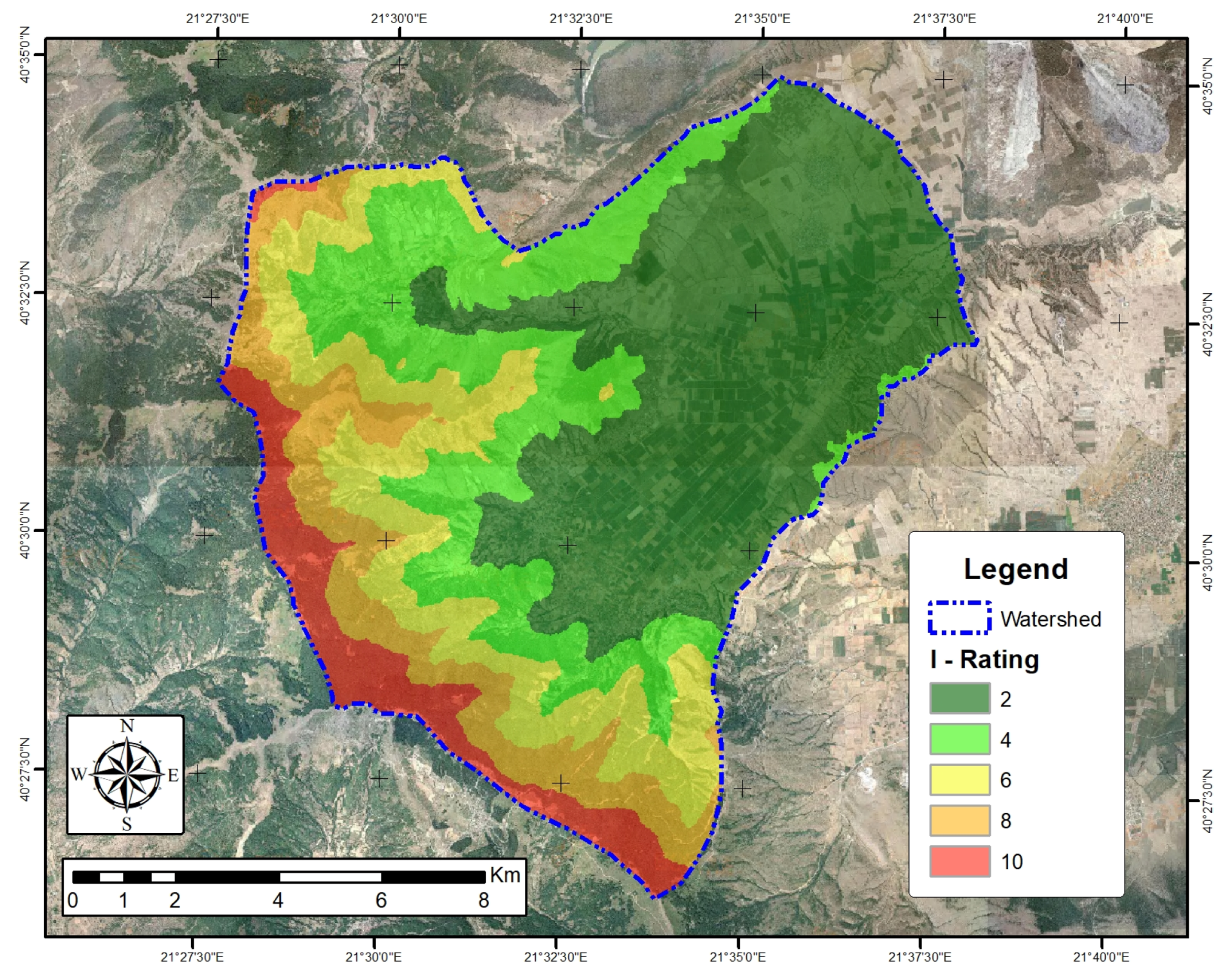
The parameter of rainfall intensity (I) is expressed using the modified Fournier index (MFI), which is the sum of the average monthly rainfall intensity recorded by the rain-gauge stations. The spatial distribution of this criterion was found using the spline interpolation method in order to also take into account the allocation of stations in the studied area. The values of the parameter I are distinguished by five classes between M F I = 45 and M F I = 93 , as shown in Table 1. The spatial distribution of the values of rain intensity is illustrated in Figure 3 with the higher values located in the southwest part of the studied area.

3.3. Geology (G)

The parameter of geology is important for the characterization of flood hazard areas, because it can potentially influence the magnitude of flood events. While impermeable rocks favor surface runoff and increase the intensity of floods, permeable formations favor water infiltration. According to the geology, five ratings were given, with crystalline rocks being attributed the highest value. Marbles were rated with 8; lower ratings were given to neogene, terrace and alluvial deposits because of their increasing infiltration capacity (Table 1). Figure 4 shows the spatial distribution of the values of the parameter of geology.

3.4. Land Use (U)

The land use parameter is mainly related to the infiltration rate as a result of the existing correlation between the surface characteristics that affect (sub)surface runoff, groundwater infiltration and debris flow. Land use information was extracted from the Corine land cover dataset [22], showing that a large part of the studied area is covered by mixed forests and agricultural areas, assigned with rates equal to 2 and 6, respectively (Figure 5). Forest generally favors infiltration, while agricultural areas allow more water to flow in the form of surface or subsurface runoff. Urban and sparsely vegetated areas represent only a fraction of the studied basin.

3.5. Slope (S)

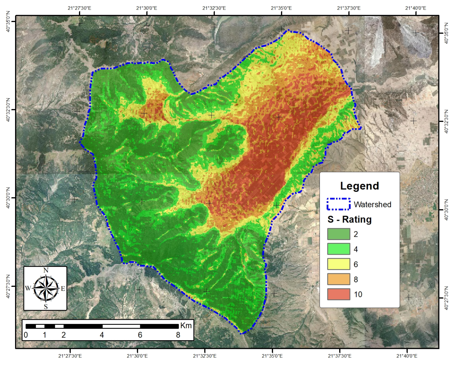
Slope is highly correlated to both the volume and the velocity of the surface runoff, as well as the infiltration to the groundwater. Flat areas flood quicker than inclined areas where runoff flows further down. The slope map was built from the digital elevation model (DEM) of the area with a 25 × 25 m 2 cell resolution. Following the classification described in the bibliography [23], five slope classes were defined. Figure 6 illustrates the spatial distribution of the slope, showing that the northeastern part—the highly-elevated area—is steeper. The central and eastern parts have a smaller slope mainly covered by forest.

3.6. Elevation (E)

As water flows from higher to lower elevation, lowland areas are more prone to flooding occurrences. The elevation map was obtained from the reclassification of the DEM of the studied river basin. Table 1 shows the definitions of the five grades for the elevation, while Figure 7 illustrates their distribution. The elevation increases from the southwestern to northeastern areas from ≃600 to ≃1700 m. Thus, an increase of more than 1000 m takes place over a distance of approximately 20 km, clearly indicating the steep northeastern part of the region. Low-elevation areas are located mostly in the western part, in the south, and—partially—in the central part of the studied watershed.

3.7. Distance from Drainage Network (D)

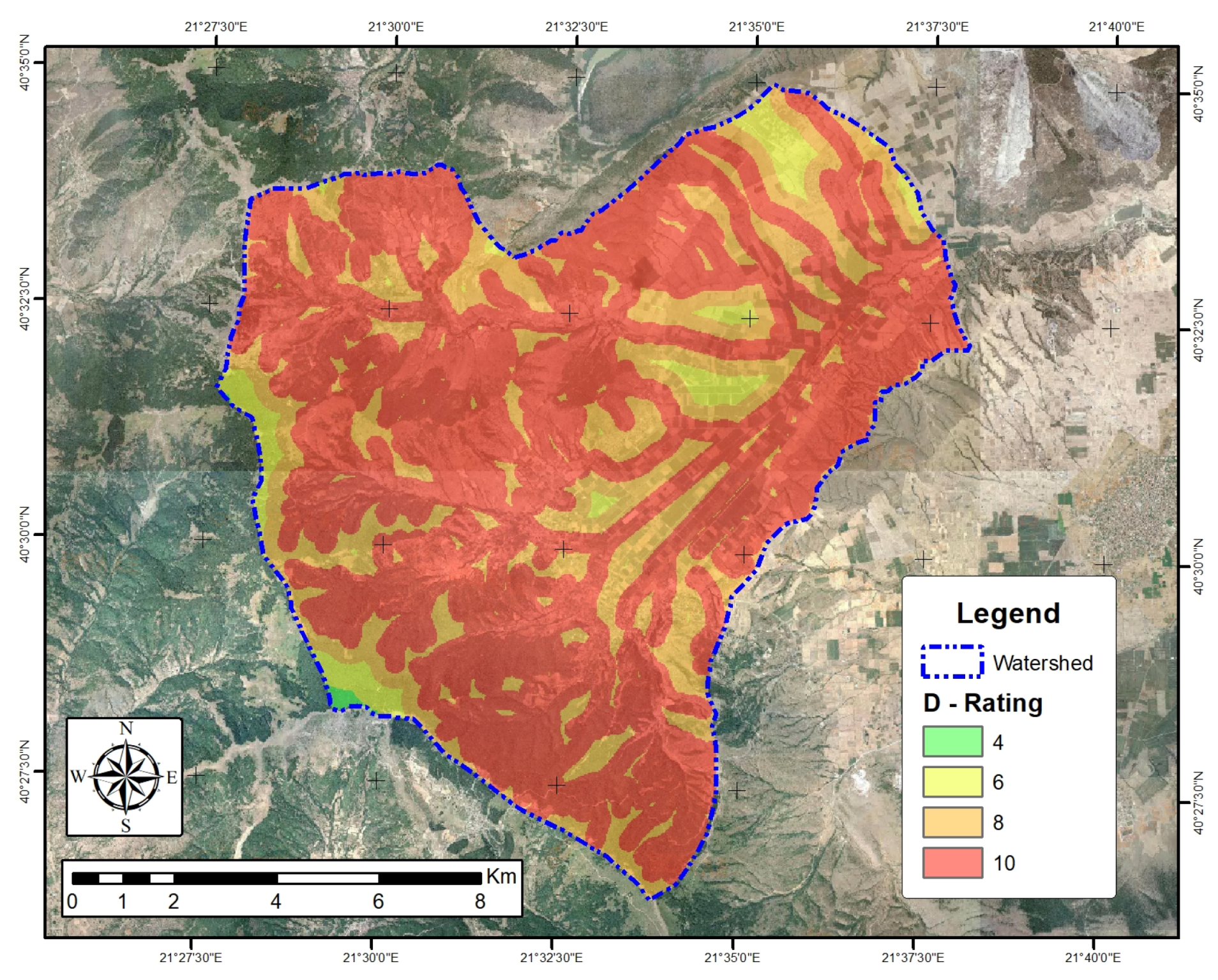
River overflows may also trigger a flood event, because the water overtops the river channel slopes and expands in the surroundings. As the distance increases, the hazard decreases, because areas closer to the river network are prone to this hazard. The distance from the drainage network layer was defined by applying a buffer zone tool in a GIS environment, in conjunction with the existing drainage network. Areas close to the drainage network were regarded as being those less than 200 m; the exact classification is presented in Table 1. In an opposite manner, the effect of this criterion decreased for distances larger than 2000 m. Figure 8 illustrates the cell values of the D index, which follow the geometry of the drainage network, with the highest values being located in the western part.
Naturally, additional parameters can be considered according to specific regional characteristics and data availability. This may include new parameters, for example, the evapotranspiration or derivative parameters such as the maximum annual peak precipitation, the mean annual count of heavy precipitation days and others [24].

4. Results and Discussion

The FIGUSED-S method analyzes the above hydrogeological, morphological and socioeconomic parameters and assigns a relative weight to each factor. The studied area was thus analyzed spatially, and each grid-point was evaluated for each of the seven parameters. Each grid-point was then rated on a scale between 2 and 10. The rating of the parameters in the studied location, and the corresponding area and its share are shown in Table 1.
The acquired values have been processed in order to calculate the relative significance of each criterion and the corresponding weighting factor (w). These relative weights were determined through an analytical hierarchical process (AHP), detailed information of which is also available in [11]. The additional feature of the FIGUSED-S method over the FIGUSED method (-S in the acronym) is the validation process performed through a sensitivity analysis. Thus, the validated version of the method also incorporates this statistical characteristic as an attempt to ensure that the weights of the used parameters are representative. Performing a sensitivity analysis is highlighted in similar methods available in the literature [25,26,27]. A pairwise comparison was carried out for the development of the FIGUSED method, using a 7 × 7 matrix. The relevant importance among the various parameters was determined following relevant experience in the literature as well as specific suggestions provided by experts’ consultation. Accordingly, the raster calculator tool of the GIS was used to overlay the rated parameters and adjust the produced weights. According to the obtained values, a flood hazard map was produced. The seven parameters influenced, with their assigned weight, the map superimposition by Equation (1):
F H I S = 1.2 × F + 0.5 × I + 0.4 × G + 0.7 × U + 1.6 × S + 3.0 × E + 2.5 × D
Equation (1) above shows the weights attributed to each of the seven parameters, as a result of the AHP. It appears that the parameters elevation and distance from the drainage play the most significant role in the definition of the flood hazard. This shows that the AHP achieves the interpreting of physical phenomena that dictate that low-elevated areas near the drainage network are particularly prone to flooding. Flood accumulation and land cover use are two parameters with relevant importance in terms of the definition of the flood hazard. Rainfall intensity and the geology parameters appear to have a lesser role, according to the AHP. This is likely due to the fact that almost two-thirds of the studied area fall in the first two classes of the I parameter. Additionally, the variance of the parameter I is relatively low (between 45 and 93 mm/month). In cases in which this variance was higher [11], the weight of the parameter I appeared to increase.
Table 1 includes the share of the zones according to their risk. It appears that one-sixth of the total studied area (16.1%) faces a very high flood hazard risk, while for an additional 31.6% of the studied area, the hazard risk is high. This is equal to almost half of the studied area (47.7%) being subject to high or very high flood hazard risk. An additional 22.8% of the area is prone to a medium hazard risk, while 21.6% and 7.9% of the area are subject to low and very low flood hazard risks, respectively.
The weighted superimposition of the analyzed criteria resulted in the creation of the flood hazard map of the region. This map is illustrated in Figure 9 and shows that the zones with high/very high flood hazard risks are located in the central and northwestern part of the studied area. It is clear that the flood hazard follows the drainage network, and prone areas are those located near the rivulets. More important is the observation that seven out of the nine total inhabited small towns are located in areas of high or very high flood hazard risks. This is particularly apparent in two settlements in the northwestern part, which are “surrounded” by areas of very high risk. Accordingly, flood mitigation measures need to start from these locations, in order to support the flood resilience of the settlements.
The successful application of the FIGUSED-S method in a small river basin verifies the adaptability of the method. Additionally, this study constitutes the base for a future modification of this method, adding new parameters. Additionally, a cross-comparison of the obtained results with flood simulation scenarios can further improve the FIGUSED-S method. Finally, it is worth mentioning that the interaction between groundwater and surface water is neglected in flood hazard mapping. Although the infiltration coefficient in geological formations is considered in the FIGUSED-S method, the contribution of springs and groundwater discharge in rivers has been studied less.
Flood hazard maps can be useful tools in the case that the results are adapted and proceed to measures such as land use changes and small dam establishment in torrents. Flood hazard areas are sensitive to forest changes and can dramatically change the regime of a region [28]. Storm events driven by climate change can also exacerbate flood events [29,30]. Detailed strategies for natural hazard mitigation have been proposed by several researchers [31]. In the Mouriki Basin, the land use changes in lowlands in conjunction with small dams in the mountainous part might be the optimal solution for flood mitigation.
The present study incorporates a weighted linear combination (WLC) of the various parameters. The basic requirement of this approach is that the attribute maps are not highly correlated and are independent of each other. The combined maps illustrated in Section 3 (Figure 2, Figure 3, Figure 4, Figure 5, Figure 6, Figure 7 and Figure 8) are not highly correlated, allowing the use of the WLC. Whether WLC is the best technique for this application or not is a question that has been the subject of considerable debate among scholars [32]. Although it is not possible to provide a straightforward answer, it is certain that, as a result of its efficacy, WLC is one of the most widely used GIS-based techniques.
The analytical hierarchy process has been widely used in the assessment of natural hazards. In the current literature, one can find modified options and hybrid approaches, such as the fuzzy AHP [33] and Monte Carlo simulation-aided AHP (MC-AHP) [34], which have both been used in flood hazard assessment. AHP has also been integrated with a suitability assessment model to evaluate flood risks in a spatial manner [35]. In a different approach, Liu et al. [36] have recently used a naïve Bayes approach to spatially assess flood risk in their GIS-based model.
The authors intend to combine the presented index methodology with simulation models, developing a more sophisticated methodology that couples the outcome of the two models. The scale of such an analysis is the river basin scale. To date, Vu and Ranzi et al. [37] have developed the FLO-2D model and applied it in the coastal province of Quang Ngai in Vietnam so as to estimate the flood depth, duration and velocity [37]. However, in many cases, a lack of reliable data hinders the simulation processes. This issue, particularly for flood hazard assessment, has been highlighted by Kabenge et al. [38] in their recent work [38].

5. Conclusions

The FIGUSED-S method was mainly developed for regional hazard assessment. Here we show an application of the method to a small hydrological basin. The majority of the study area is characterized by moderate to very high flood hazard risks; 16% of the study area is characterized by very high flood hazard risk, while a high flood hazard risk affects 32% of the lowlands. The Mouriki Basin is dominated by agricultural and livestock activities. Therefore, the provided flood hazard map can be used for flood prevention, adapting mitigation strategies and/or protection measurements.
A further step of this study was the flood simulation in order to determine the depth, duration and velocity of floods, as well as to quantify the interaction between groundwater and surface water during flood events. Coupling the obtained hydrologic information with water resources management analytical tools can allow for the designing of strategies for the optimal allocation of the water resource [39] and the minimization of the flood risk. It will also allow for the better utilization of existing infrastructure in rural, remote areas such as the irrigation dams [40] in an integrated manner.

Author Contributions

Olga Patrikaki conceived the activity, coordinated data collection and implemented its harmonization. Nerantzis Kazakis developed the methodology and performed the spatial analysis, including the preparation of the maps. Ioannis Kougias participated in the methodology design and model definition, as well as drafted the main text. Thomas Patsialis participated in the methodology design and supported the GIS analysis. Nicolaos Theodossiou provided input on integrated water resources management in the river basin. Konstantinos Voudouris provided all relevant background information, drafted the introduction and supervised the activity.

Conflicts of Interest

The authors declare no conflict of interest.

Abbreviations

The following abbreviations are used in this manuscript:
AHPAnalytical hierarchy process
AIArtificial intelligence
DEMDigital elevation model
FHIFlood hazard index
GISGeographic information system
MFIModified fournier index
OECDOrganisation for Economic Co-operation and Development
RFRandom forest
WLCWeighted linear combination

References

  1. Kowalzig, J. Climate, Poverty, and Justice: What the Poznan UN climate conference needs to deliver for a fair and effective global deal. Oxfam Policy Pract. Clim. Chang. Resil. 2008, 4, 117–148. [Google Scholar]
  2. Intergovernmental Panel on Climate Change. Climate Change 2014—Impacts, Adaptation and Vulnerability: Regional Aspects; Cambridge University Press: Cambridge, UK, 2014. [Google Scholar]
  3. Voudouris, K. Engineering Hydrogeology; Tziolas Publ.: Thessaloniki, Greece, 2017. (In Greek) [Google Scholar]
  4. Diakakis, M. Flood seasonality in Greece and its comparison to seasonal distribution of flooding in selected areas across southern Europe. J. Flood Risk Manag. 2017, 10, 30–41. [Google Scholar] [CrossRef]
  5. Kourgialas, N.N.; Karatzas, G.P. Flood management and a GIS modelling method to assess flood-hazard areas—A case study. Hydrol. Sci. J. 2011, 56, 212–225. [Google Scholar] [CrossRef]
  6. Kourgialas, N.N.; Karatzas, G.P. A national scale flood hazard mapping methodology: The case of Greece–Protection and adaptation policy approaches. Sci. Total Environ. 2017, 601, 441–452. [Google Scholar] [CrossRef] [PubMed]
  7. Papaioannou, G.; Loukas, A.; Vasiliades, L.; Aronica, G. Flood inundation mapping sensitivity to riverine spatial resolution and modelling approach. Nat. Hazards 2016, 83, 117–132. [Google Scholar] [CrossRef]
  8. Angelidis, P.; Kotsikas, M.; Kotsovinos, N. Management of upstream dams and flood protection of the transboundary river Evros/Maritza. Water Resour. Manag. 2010, 24, 2467–2484. [Google Scholar] [CrossRef]
  9. Nasiri, H.; Yusof, M.J.M.; Ali, T.A.M. An overview to flood vulnerability assessment methods. Sustain. Water Resour. Manag. 2016, 2, 331–336. [Google Scholar] [CrossRef]
  10. Domakinis, C.; Oikonomdis, D.; Voudouris, K.; Astaras, T. Using geographic information systems (GIS) and remote sensing to map flood extent and to assess flood hazard in erythropotamos river basin (Evros, Greece). In Proceedings of the 10th International Congress of the Hellenic Geographical Society, Thessaloniki, Greece, 22–24 October 2014; pp. 689–709. [Google Scholar]
  11. Kazakis, N.; Kougias, I.; Patsialis, T. Assessment of flood hazard areas at a regional scale using an index-based approach and Analytical Hierarchy Process: Application in Rhodope—Evros region, Greece. Sci. Total Environ. 2015, 538, 555–563. [Google Scholar] [CrossRef] [PubMed]
  12. Tsitroulis, I.; Voudouris, K.; Vasileiou, A.; Mattas, C.; Sapountzis, M.; Maris, F. Flood hazard assessment and delimitation of the likely flood hazard zones of the upper part in Gallikos River Basin. In Proceedings of the 14th International Conference, Thessaloniki, Greece, 25–27 May 2016; pp. 995–1004. [Google Scholar]
  13. Correia, F.N.; Da Silva, F.N.; Ramos, I. Floodplain management in urban developing areas. Part I. Urban growth scenarios and land-use controls. Water Resour. Manag. 1999, 13, 1–21. [Google Scholar] [CrossRef]
  14. Organisation for Economic Co-operation and Development (OECD). Global Modelling of Natural Hazard Risks: Enhancing Existing Capabilities to Address New Challenges; Report; Organisation for Economic Co-operation and Development: Paris, France, 2012. [Google Scholar]
  15. Chapi, K.; Singh, V.P.; Shirzadi, A.; Shahabi, H.; Bui, D.T.; Pham, B.T.; Khosravi, K. A novel hybrid artificial intelligence approach for flood susceptibility assessment. Environ. Model. Softw. 2017, 95, 229–245. [Google Scholar] [CrossRef]
  16. Kaur, H.; Gupta, S.; Parkash, S.; Thapa, R.; Mandal, R. Geospatial modelling of flood susceptibility pattern in a subtropical area of West Bengal, India. Environ. Earth Sci. 2017, 76, 339. [Google Scholar] [CrossRef]
  17. Termeh, S.V.R.; Kornejady, A.; Pourghasemi, H.R.; Keesstra, S. Flood susceptibility mapping using novel ensembles of adaptive neuro fuzzy inference system and metaheuristic algorithms. Sci. Total Environ. 2018, 615, 438–451. [Google Scholar] [CrossRef] [PubMed]
  18. Hong, H.; Panahi, M.; Shirzadi, A.; Ma, T.; Liu, J.; Zhu, A.X.; Chen, W.; Kougias, I.; Kazakis, N. Flood susceptibility assessment in Hengfeng area coupling adaptive neuro-fuzzy inference system with genetic algorithm and differential evolution. Sci. Total Environ. 2017, 621, 1124–1141. [Google Scholar] [CrossRef] [PubMed]
  19. Zhao, G.; Pang, B.; Xu, Z.; Yue, J.; Tu, T. Mapping flood susceptibility in mountainous areas on a national scale in China. Sci. Total Environ. 2018, 615, 1133–1142. [Google Scholar] [CrossRef]
  20. Patrikaki, O.; Kazakis, N.; Voudouris, K. Vulnerability map: A useful tool for groundwater protection: An example from Mouriki Basin, North Greece. Fresenius Environ. Bull. 2012, 21, 2516–2521. [Google Scholar]
  21. Patrikaki, O. Hydrogeological Research of Potamia Basin, in Kozani Prefecture, in Northern Greece. Ph.D. Thesis, Department of Geology, Aristotle University of Thessaloniki, Thessaloniki, Greece, 2009. (In Greek). [Google Scholar]
  22. Bossard, M.; Feranec, J.; Otahel, J.; Steenmans, C. The Revised and Supplemented Corine Land Cover Nomenclature; European Environment Agency: Copenhagen, Denmark, 2000. [Google Scholar]
  23. Demek, J. Manual of Detailed Geomorphological Mapping; Academia: San Francisco, CA, USA, 1972. [Google Scholar]
  24. Liu, R.; Chen, Y.; Wu, J.; Gao, L.; Barrett, D.; Xu, T.; Li, X.; Li, L.; Huang, C.; Yu, J. Integrating Entropy-Based Naïve Bayes and GIS for Spatial Evaluation of Flood Hazard. Risk Anal. 2017, 37, 756–773. [Google Scholar] [CrossRef] [PubMed]
  25. Gao, L.; Hailu, A. Ranking management strategies with complex outcomes: An AHP-fuzzy evaluation of recreational fishing using an integrated agent-based model of a coral reef ecosystem. Environ. Model. Softw. 2012, 31, 3–18. [Google Scholar] [CrossRef]
  26. Gao, L.; Hailu, A. Identifying preferred management options: An integrated agent-based recreational fishing simulation model with an AHP-TOPSIS evaluation method. Ecol. Model. 2013, 249, 75–83. [Google Scholar] [CrossRef]
  27. Zhang, X.; Gao, L.; Barrett, D.; Chen, Y. Evaluating water management practice for sustainable mining. Water 2014, 6, 414–433. [Google Scholar] [CrossRef]
  28. Bhattacharjee, K.; Behera, B. Forest cover change and flood hazards in India. Land Use Policy 2017, 67, 436–448. [Google Scholar] [CrossRef]
  29. Clark, G.E.; Moser, S.C.; Ratick, S.J.; Dow, K.; Meyer, W.B.; Emani, S.; Jin, W.; Kasperson, J.X.; Kasperson, R.E.; Schwarz, H.E. Assessing the vulnerability of coastal communities to extreme storms: the case of Revere, MA., USA. Mitig. Adapt. Strateg. Glob. Chang. 1998, 3, 59–82. [Google Scholar] [CrossRef]
  30. Ratick, S.J.; Morehouse, H.; Klimberg, R.K. Creating an index of vulnerability to severe coastal storms along the North Shore of Boston. In Financial Modeling Applications and Data Envelopment Applications; Emerald Group Publishing Limited: Bingley, UK, 2009; pp. 143–178. [Google Scholar]
  31. Runfola, D.M.; Ratick, S.; Blue, J.; Machado, E.A.; Hiremath, N.; Giner, N.; White, K.; Arnold, J. A multi-criteria geographic information systems approach for the measurement of vulnerability to climate change. Mitig. Adapt. Strateg. Glob. Chang 2017, 22, 349–368. [Google Scholar] [CrossRef]
  32. Malczewski, J. On the use of weighted linear combination method in GIS: Common and best practice approaches. Trans. GIS 2000, 4, 5–22. [Google Scholar] [CrossRef]
  33. Xiao, Y.; Yi, S.; Tang, Z. Integrated flood hazard assessment based on spatial ordered weighted averaging method considering spatial heterogeneity of risk preference. Sci. Total Environ. 2017, 599, 1034. [Google Scholar] [CrossRef] [PubMed]
  34. Dahri, N.; Abida, H. Monte Carlo simulation-aided analytical hierarchy process (AHP) for flood susceptibility mapping in Gabes Basin (southeastern Tunisia). Environ. Earth Sci. 2017, 76, 302. [Google Scholar] [CrossRef]
  35. Chen, Y.; Liu, R.; Barrett, D.; Gao, L.; Zhou, M.; Renzullo, L.; Emelyanova, I. A spatial assessment framework for evaluating flood risk under extreme climates. Sci. Total Environ. 2015, 538, 512–523. [Google Scholar] [CrossRef] [PubMed]
  36. Liu, R.; Chen, Y.; Wu, J.; Gao, L.; Barrett, D.; Xu, T.; Li, L.; Huang, C.; Yu, J. Assessing spatial likelihood of flooding hazard using naïve Bayes and GIS: A case study in Bowen Basin, Australia. Stoch. Environ. Res. Risk Assess. 2016, 30, 1575–1590. [Google Scholar] [CrossRef]
  37. Vu, T.T.; Ranzi, R. Flood risk assessment and coping capacity of floods in central Vietnam. J. Hydro-Environ. Res. 2017, 14, 44–60. [Google Scholar] [CrossRef]
  38. Kabenge, M.; Elaru, J.; Wang, H.; Li, F. Characterizing flood hazard risk in data-scarce areas, using a remote sensing and GIS-based flood hazard index. Nat. Hazards 2017, 89, 1369–1387. [Google Scholar] [CrossRef]
  39. Kougias, I.; Karakatsanis, D.; Malatras, A.; Monforti-Ferrario, F.; Theodossiou, N. Renewable energy production management with a new harmony search optimization toolkit. Clean Technol. Environ. Policy 2016, 18, 2603–2612. [Google Scholar] [CrossRef]
  40. Patsialis, T.; Kougias, I.; Kazakis, N.; Theodossiou, N.; Droege, P. Supporting Renewables’ Penetration in Remote Areas through the Transformation of Non-Powered Dams. Energies 2016, 9, 1054. [Google Scholar] [CrossRef]
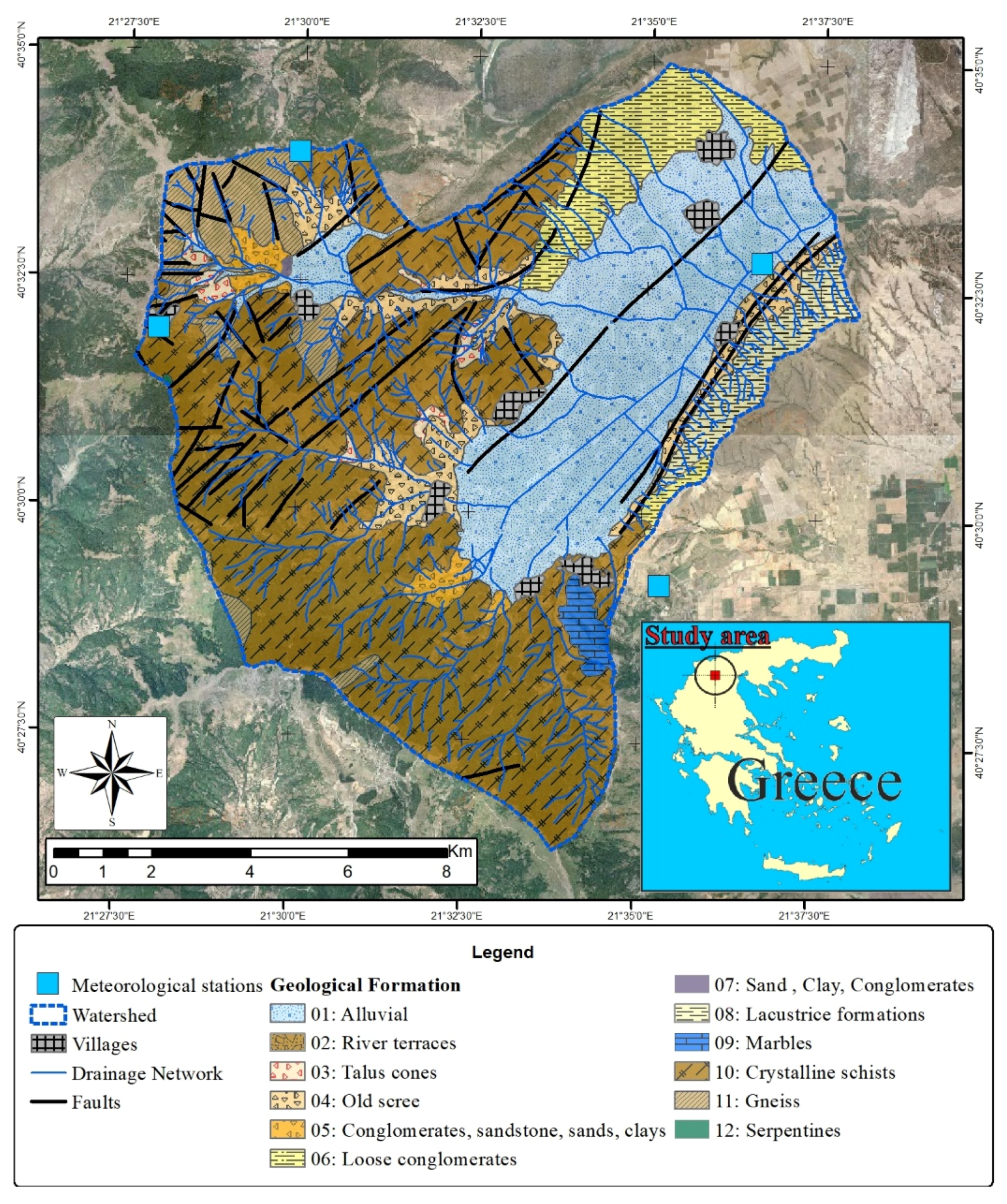
Figure 1. The studied area: geological mapping.
Geosciences 08 00050 g001
Figure 2. F index in the studied region.
Geosciences 08 00050 g002
Figure 3. I index in the studied region.
Geosciences 08 00050 g003
Figure 4. G index in the studied region.
Geosciences 08 00050 g004
Figure 5. U index in the studied region.
Geosciences 08 00050 g005
Figure 6. S index in the studied region.
Geosciences 08 00050 g006
Figure 7. E index in the studied region.
Geosciences 08 00050 g007
Figure 8. D index in the studied region.
Geosciences 08 00050 g008
Figure 9. Flood hazard map of the studied area as a result of the FIGUESD-S methodology.
Geosciences 08 00050 g009
Table 1. Classes of the parameters of the FIGUSED-S method and according values.
ParametersClassRatingArea (km 2 )Share (%)
F: Flow Accumulation0–58212132.799.2
5822–24,94740.50.4
24,948–59,04160.20.2
59,042–90,64180.10.1
90,642–212,049100.10.1
I: Rainfall Intensity45–50257.443.0
51–58429.121.8
59–66621.416.0
66–76815.111.3
77–931010.78.0
G: GeologyAlluvial236.227.1
Terrace420.715.5
Neogene64.53.3
Marbles81.31.0
Crystalline rocks1071.053.1
U: Land useMixed Forest255.141.2
Sparsely vegetated46.54.9
Agricultural652.939.6
Pastures816.812.5
Urban102.51.9
S: Slope0–21046.234.5
2–5831.623.6
5–15620.515.3
15–35417.513.1
>35217.913.4
E: Elevation627–738211.08.2
739–903415.111.3
904–1089621.416.0
1090–1300829.121.8
1301–16801057.142.7
D: Distance from drainage>200020.00.0
1000–200040.20.2
500–100065.64.2
200–500831.723.7
<2001096.271.9
FIGUSED: Flood hazard32–49Very low10.67.9
50–59Low28.821.6
60–67Moderate30.522.8
68–74High42.331.6
75–89Very high21.616.1