Article

Survey Tool for Rapid Assessment of Socio-Economic Vulnerability of Fishing Communities in Vietnam to Climate Change

by
John Erick Avelino
1,*,
Richard Nathan Crichton
1,
Ven Paolo Valenzuela
1,
Merenchi Galappaththige Nipuni Odara
1,
Michael Adrian Triguero Padilla
1,
Nguyen Kiet
2,
Dang Hoang Anh
2,
Pham Cam Van
3,
Ho Dac Bao
2,
Nguyen Hoang Phuong Thao
3,
Mai Thi Yen Linh
2,
Pham Thi Phuoc Hoai
2,
Nguyen Danh Thao
2,
Motoharu Onuki
1 and
Miguel Esteban
4
1
GPSS-GLI, University of Tokyo, Kashiwanoha, Chiba 277-8563, Japan
2
Department of Port and Coastal Engineering, Faculty of Civil Engineering, Ho Chi Minh City University of Technology, Ho Chi Minh City 70000, Vietnam
3
Faculty of Environmental Engineering, Vietnam-Japan University, Ha Noi 10000, Vietnam
4
Research Institute of Sustainable Future Society, Faculty of Civil and Environmental Engineering, Waseda University, Tokyo 163-8001, Japan
*
Author to whom correspondence should be addressed.
Geosciences 2018, 8(12), 452; https://doi.org/10.3390/geosciences8120452
Submission received: 17 October 2018 / Revised: 10 November 2018 / Accepted: 29 November 2018 / Published: 3 December 2018
(This article belongs to the Special Issue River, Urban, and Coastal Flood Risk)

Abstract

:
Climate change will likely affect the effectiveness of future management of coastal ecosystems, impacting communities that reside within the coastal area. In order to formulate appropriate adaptation counter-measures it is important to understand the actual vulnerability of the communities that depend on these ecosystems. The present research proposes a tool for assessing the vulnerability of coastal communities to climate change by combining survey results with secondary and observed data available from national and local governments. The study focused on fisheries, given that they constitute the source of livelihood for many communities in developing countries such as Vietnam. The results showed that two coastal wards in Binh Thuan province, Vietnam, are highly vulnerable to the impacts of climate change, mainly because of their dependence on fisheries and the topography of the area. The seasonality of their source of livelihood affects the adaptive capacity of residents, making it less likely that they will be able to successfully adapt to changes in fishery resources that could be brought about by climate change. The results also showed that the communities are particularly vulnerable to sea level rise, given that they are both located in the immediate vicinity of the sea and are particularly low in elevation.

1. Introduction

Since the first Intergovernmental Panel on Climate Change (IPCC) report was issued in 1990, climate change has become one of the most pressing challenges facing humanity, requiring a holistic approach to mitigation and adaptation through various government and civil efforts. Addressing climate change impacts requires knowledge of the interaction between environmental, economic, social and other factors [1]. Among the most vulnerable society sectors to climate change impacts are the poor and those that depend heavily on fisheries for sustenance. Their vulnerability to external disruptions, coupled with a lack of coping mechanisms, can have profound impacts on their livelihood and negatively affect the economic growth of the countries in which they reside [2].
Globally, the fishing sector supports nearly 200 million livelihoods. Around 43.5 million people are working directly in the sector, with the majority residing in developing countries such as Vietnam [3]. Vietnam is one of the most vulnerable countries to coastal disasters, as it has a 3260 km long coastline [4]. As most of its cities are located along the coast, it is inevitable that climate change will aggravate current socio-economic problems in the near future, once the impacts of climate change and sea level rise start to be more acutely felt. These vulnerabilities to climate change and sea level rise are higher where the stresses on natural low-lying coastal systems coincide with low human adaptive capacity and/or high exposure. The Government of Vietnam has addressed these concern at the policy level through a series of climate change related policies, including the “National Strategy on Climate Change (2011)”, “National Target Program to Respond to Climate Change (2012)” and the “Green Growth Strategy (2012)” which are all aligned with the “Socio-Economic Development Strategy/Plan (2010)”, the country’s national economic development plan [5].
Essentially, sea level rise (SLR), increases in typhoon intensity, droughts and ocean acidification are some of the worst expected consequences of climate change for coastal communities in Vietnam [6]. Since 1990 it is estimated that the rate of SLR increased to about 3 mm per year, significantly higher than during the previous half a century. This rate of increase varies across regions, though for the case of Vietnam it is in line with the world’s average of around 1.75 to 2.56 mm/year [7]. The IPCC 5AR indicates the oceans will continue to warm and that this heat will start to penetrate deeper into the ocean, with the upper ocean (0–700 m depth) already reported a warming average of 0.11 °C. Recent work on probabilistic process-based models that take into account rapid losses in the Antarctic ice sheets put the potential for SLR to an upper range of 2.97–3.39 m (for RCP 8.5 scenarios, see [8,9]).
The IPCC 5AR also outlines how as a consequence of global warming the intensity of typhoons could increase in the future, which could have significant consequences for Vietnam, as it is frequently affected by typhoons, particularly along the central coastline of the country [10]. Warm waters fuel tropical cyclones and thus in a future of warming seas it is likely that their intensity will increase, as indicated by computer simulations [11,12]. Knutson et al., (2010) [13] summarized the most important research on tropical cyclone simulations and suggest that the future intensity of tropical cyclones could increase by between 2% and 11% by 2100. Stronger typhoons could result in greater damage to housing and agriculture, particularly along coastal areas [14,15]. In Vietnam, over 70% of all natural disasters are due to typhoons and the yearly frequency and economic damage totals have generally been increasing [16]. This could result in serious coastal erosion and damage to port infrastructure, coastal revetments and breakwaters [17]. Recently, coastal areas in Vietnam have experienced extreme storm events, such as Typhoon Rammasun in 2014, Typhoon Mujigae in 2015 and typhoon Damrey in 2017. These have resulted in serious consequences to Vietnamese society, such as widespread damage to public and personal properties and in some cases significant casualties.
Ocean Acidification, due to the ocean’s absorption of carbon dioxide from the atmosphere, has reportedly resulted in oyster larval mortality as pH level decreases across the ocean [18] and could potentially increase the bioaccumulation of heavy metals and lead to seafood toxicity [19]. This would have a significant effect on food security, decreasing the ability of the ocean to keep up with the growing demand for human consumption (with 2009 FAO reports [3] estimating at 16.6% the global animal protein intake comes from the oceans). Overall, climate change impacts will likely affect the coral reefs, sea grass beds and the salinity of the coastal areas, in turn potentially leading to a reduction in mangrove cover. Eventually, the amount of fish stocks, mollusks and crustaceans is expected to dramatically reduce, as all these species depend on the habitats mentioned earlier [20].
A variety of Vulnerability Assessment (VA) tools have been developed to understand emerging climate change threats, which take into consideration the different parameters that define vulnerability as a concept. In 2007, Hinkel and Klein [21] integrated into such tools biophysical components and how they affect people and infrastructure; and social aspects commonly associated with the ability of a population to respond, adapt and regain their footing after a natural calamity. In 2017, Lins-de-Barros [22] focused on showing correlations between the physical, social, geomorphological and ecosystems processes. Over the years, VAs have been conducted using a variety of approaches and different methodologies. However Nguyen et al. in 2016 [23], argued that several tools lacked consistency and were too broad, therefore lacking a convincing framework to come up with a comparable vulnerability index.
In the present work, the authors set out to develop their own VA tool to conduct rapid assessments of socio-economic vulnerability to climate change of fishing communities. The study used as its basis the Integrated Coastal Sensitivity, Exposure and Adaptive Capacity for Climate Change (I-C-SEA Change), originally developed and applied for the case of the Philippines [24]. This I-C-SEA Change tool identifies how the vulnerability of coastal areas is a function of three components namely: exposure, sensitivity and people’s adaptive capacity [24]. It combines results of simulation-model-based, indicator-based and participatory-based approaches in VA that have been attempted in several previous studies (e.g., [24,25,26]). However, due to Vietnam having a different environment in terms of biophysical components, the tool was modified to suit the coastal management philosophy priorities of this country, which is focused on the coastal infrastructures, rather than the protection of coastal ecosystems, like in the case of the Philippines. Currently, adaptation measures in coastal areas in Vietnam includes the strengthening and elevation of embankments nationwide, which emphasizes investments in “adaptive” infrastructure. Moreover, the National Climate Change Strategy of Vietnam prioritizes mitigation activities from 2013–2025 in association to socio-economic development, unlike most other South East Asian countries (which looks at ecosystem based adaptation to climate change).
Using the national projection on climate change impacts as basis, this research tries to assess the level of vulnerability of a specific community, compared to others in Vietnam. In addition, the tool proposed by the authors adds an element of collective response from the community to indicators that were identified by previous VA tools. In 2004, Tompkins and Adger [27] argued that in order to increase the resilience of a community, the mechanisms of climate change adaptation and mitigation need to evolve through collective action. Although climate mitigation requires a coordinated approach, some research has argued that the forefront of actions to address climate change impacts should be conducted by local officials. Knaepen showed that despite laws adopted by the national government of Vietnam, mainstreaming of climate change initiatives down to the local governments is still limited and has not translated into new policy arrangements [28].
The new methodology developed was then applied to investigate the difference in the level of vulnerability of two coastal communities in Southern Vietnam to climate change impacts.

2. Materials and Methods

As stated earlier, the authors developed their own tool to conduct rapid assessments of socio-economic vulnerability of fishing communities to climate change, which was based on the methodology outlined by Reference [24] for the case of the Philippines, which was modified to better reflect the coastal management philosophy priorities in Vietnam.
The present research uses a quantitative-qualitative approach in gathering data to provide a holistic understanding of the nexus between climate change impacts and the coastal communities it will affect. The research team sought information from local people and organizations on their perception of the impacts of climate change to their livelihoods through questionnaire surveys, semi-structured interviews and key informant interviews.
The questionnaire surveys were administered by the authors themselves amongst local fishermen, vendors and residents, in the target case studies areas, with a total of 80 (n = 80) respondents for each of the sites being surveyed. The questionnaires were four pages long, with a total of thirteen (13) questions on them. These questions were asked verbally by the enumerators to respondents in Vietnamese, with the written answers being later translated into English. Care was taken not to influence or prime the respondents in any way. The questions included were all quantitative, with the enumerators recording the answer on a scale. However, some questions offered the possibility of respondents to answer something else and all these responses were also computed in the final analysis. The questions included the number of years they had been working on fishing, the type of gears used, type of fish catch, the average fish catch, whether they fished onshore or offshore, what is the average daily catch, how many meals did they eat per day, how often did they eat fish, who is the primary buyer of the catch, whether they had a source of livelihood other than fishing, what was their approximate monthly income, the highest educational level attained, whether they had been engaged in any fishery management project by the local government and whether there had been any benefits from such projects.
Semi-structured interviews and key informant interviews were also carried out in the area, with a total of 5 experts being approached. These included officials from the Ministry of Natural Resources and Environment (MoNRE) and the Local Government of the City of Phan Thiet. The answers from these experts were used to triangulate and further shed light on the answers provided by the respondents of the questionnaire surveys.
In addition, the methodology employed also included the use of secondary data gathering from academia conducting coastal resources monitoring in the area and the Vietnam Institute of Meteorology, Hydrology and Environment.
As it is difficult to predict long-term changes in adaptation capacity and institutional change, a “short-term” Vulnerability Assessment was developed, using the exposure levels for the “early” 21st century (2016–2035) identified by the Ministry of Natural Resources and Environment (MoNRE) [6]. The use of a short-term projection aims to strike a balance between anticipatory and responsive adaptation to climate change impacts.

2.1. Study Areas

Phan Thiet City, in southern Vietnam, was the target location for the study. The city is particularly vulnerable to coastal erosion, having had over 239.8 ha of erosion in recent times [10]. Furthermore, while tourism has risen in the area, the majority of Phan Thiet communities are still largely dependent on fisheries. This makes the communities in it extremely vulnerable to future climate change impacts and an important case for research. Two wards within the city were selected as study sites, both being characterized by having fisheries as their main source of livelihood (“Wards” are the smallest administrative unit in the Socialist Republic of Vietnam, where the People’s Councils and People’s Committees are established according to the country’s law).
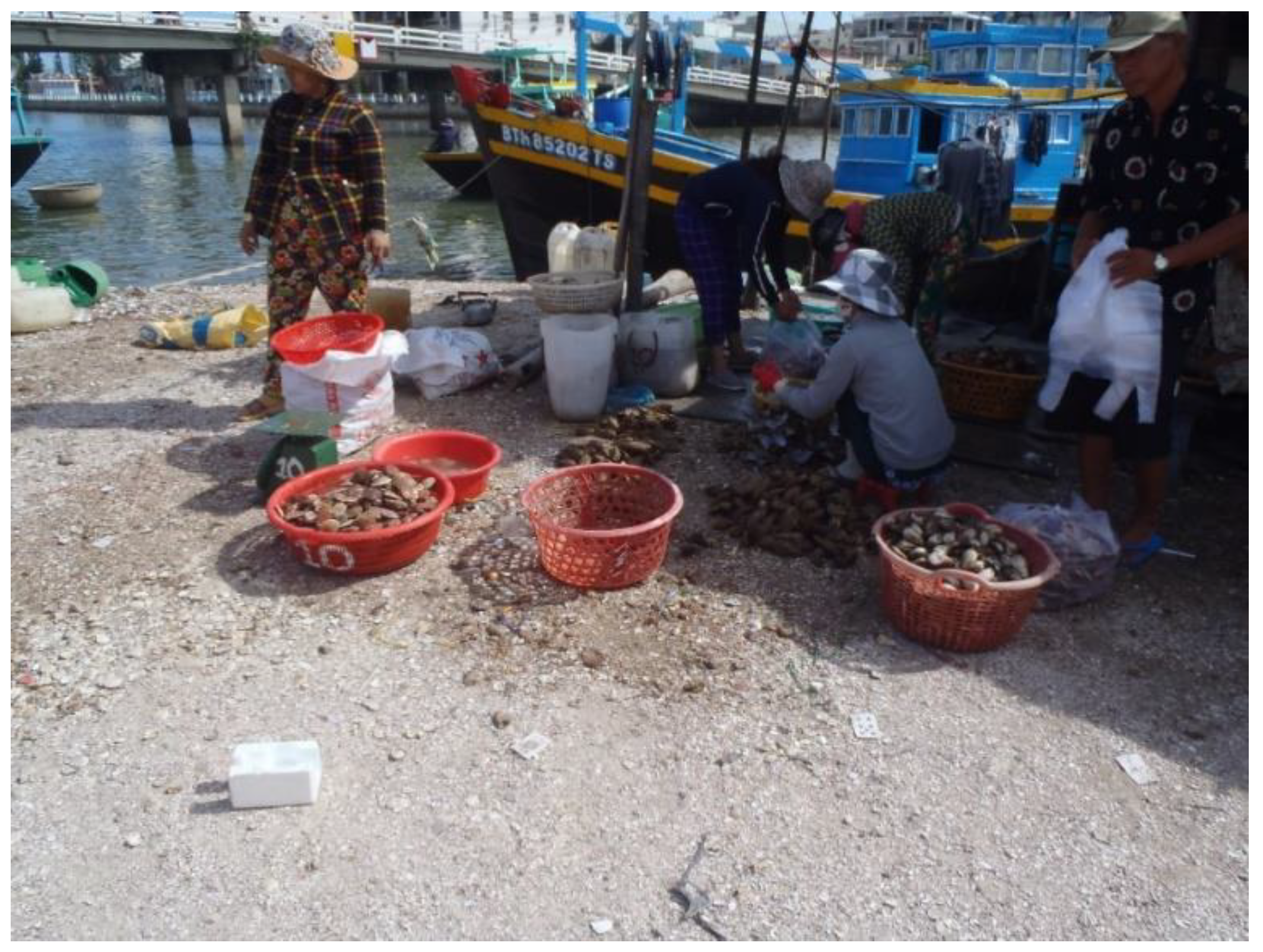
  • Phu Trinh, having one of the highest population densities in the region (Figure 1), is a small fishing community built on top of land at the side of a river bank, formed through the accumulation of mud, solid waste and discarded seashells and seafood waste (Figure 2). It is one of the lowest-lying areas in the city of Phan Thiet and thus particularly vulnerable to sea level rise, storm surges and fluvial flooding [29].
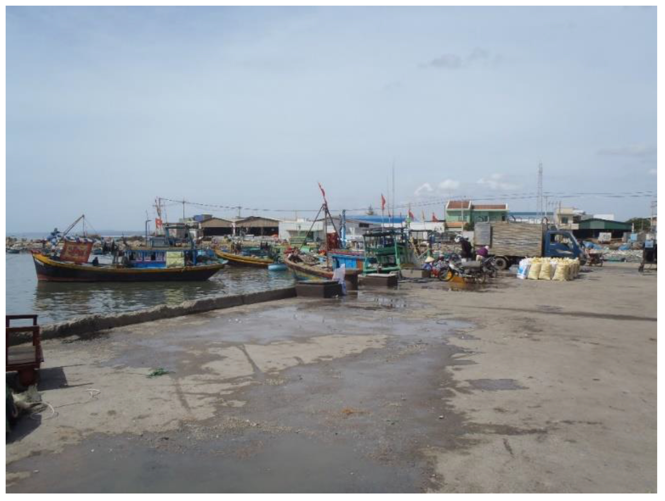
  • Duc Long, is an area of the city that has been experiencing significant beach erosion. In this area, improvised beach erosion protection, such as the use of sandbags, has been practiced for some time. However, these improvised measures were not successful in stopping the erosion [10]. As with Phu Trinh, Duc Long is also one of the most densely populated areas in the province of Binh Thuan, with significant numbers of fishermen (Figure 3).

2.2. Scoring Guide

The scoring guide builds on the principles set by the IPCC 5AR to cover the three components of vulnerability [30]. Essentially, vulnerability is an overlapping function of exposure, which takes into account the physical effects of climate change (E), sensitivity (S, which is the dependence of an economy from a sector for economic and social returns) and the adaptive capacity (AC, which can overcome the potential negative impacts of climate change [31]; IPCC, 2001 as cited by [2]).
By identifying indicators which are applicable to the case study area, the research was able to develop a tool that can accurately capture the vulnerability of fishing communities in Vietnam. Scoring rubrics were developed for each of these indicators, wherein the description of the values for each of the indicator is given a corresponding score.

2.3. Assessing Exposure

For the purpose of this research, exposure values were based on the projections of three climate change variables, namely: temperature, rainfall and sea level rise, as developed by the Ministry of Natural Resources and Environment (MoNRE) in Vietnam [32]. To derive these projections, MoNRE used the IPCC benchmark emission scenarios coupled with dynamical downscaling through global and regional models. The scenarios were subdivided into twenty year averages, referred to as the “early” (2016–2035), “mid” (2046–2065) and “late” (2081–2100) 21st century. As stated earlier, in the present work the authors attempted to gauge “short-term” vulnerability and thus the early MoNRE scenarios were chosen to assess exposure. In Table 1, the ranges given in the RCP 4.5 climate scenario were taken as the minimum and maximum values for each of the climate change variables that indicate exposure. Exposure thresholds were identified by dividing the range of projection given at the national level into three ranges, with the actual exposure for each site being assessed based on local projections. However, instead of deriving the exposure thresholds of sea level rise from national projections, the three ranges of exposure were based on engineering judgement by the authors (based on studies on adaptation to ground subsidence, see [33,34,35]).
However, because of the lack of a downscaled projection on sea level rise, instead of using the small range of a 12 to 14 cm increase given by MoNRE [32], this paper will determine exposure to sea level rise based on the land elevation at the target sites namely: (1) High, on areas having an elevation of 0.0–0.49 m; (2) Moderate 0.5–1.99 m; and (3) High 2+ m high (Table 1).
As for change in annual rainfall, in addition to the range of increases given by MoNRE in 2016 [32], the land elevation of the selected sites was also considered [32]. When determining the value of “change in annual rainfall relative to land elevation”, a range of combinations were considered (see Table 2). This further emphasizes how sea level rise may affect the infrastructure of low-lying communities, helping to differentiate wards within a city [36].

2.4. Assessing Sensitivity

In a developing country the economy can be severely affected by risks associated with the fisheries sector [37]. In Vietnam, fish catch continues to decline due to illegal, unregulated and unreported fishing [38]. To assess the sensitivity of coastal areas in Vietnam the present research focused on fisheries as the main source of livelihood for coastal communities and determined the participation of the population in government initiated projects. In 2011, Mualil et al., identified key socioeconomic indicators that would affect the willingness of fishermen to diversity their livelihoods, so as to offset the load from fisheries during periods of low income [39]. This includes fish catch, cash incentives, frequency of fishing activity and the number of years they were active in the fishing industry.
The sensitivity indicators were separated based on the type of tool that was used to acquire their values (i.e., either the survey questionnaire—as described earlier- or field observations by the authors).
The criteria that were surveyed in the questionnaire survey (See Table 3) included the types of fish caught, with coral-reef associated fish stocks deemed to be the most vulnerable [24]. In addition, data regarding the catch rate, mobile fishing gears and dependence on fisheries were also gathered (see Table 3). For the case of low and moderate sensitivity two different point values were used to limit ambiguity, following the methodology of Licuanan et al. [24].
Regarding the criteria that were observed or obtained from literature or reports, the population thresholds were based on the 2016 statistics of World Bank (WB) on the average population in Vietnam, which was then placed in the moderate category. The indicators for the sensitivity criteria were then completed with a set of observable indicators on coastal integrity, regarding whether the land was accreting, stable or eroding, its type of material and the width of the shoreline (See Table 4).

2.5. Assessing Lack of Adaptive Capacity

The lack of adaptive capacity of the community was also assessed, using indicators such as fishing experience, consumption patterns, income diversification and education, adopted from other studies [24,40] (See Table 5). However, this study also emphasizes that although adaptive capacity can address the impacts of climate change, it cannot completely negate the impending impacts of climate change. Thus, there is no value of 1 for a low rating, though the moderate sensitivity was still separated into two different categories.
In addition to the observed physical indicators, such as solid waste accumulation and land use, the concept of mainstreaming climate change to national and local government units in Vietnam studied by Knaepen were also included [28] (See Table 6).

3. Results

The following section presents the results of the present study, touching and discussing on the most relevant and interesting results from the indicators that were described in the previous section. Note that not all indicators will be described here in detail, though all will be summarized at the end of this section in appropriate tables.

3.1. Exposure of Phan Thiet to Climate Change Variables

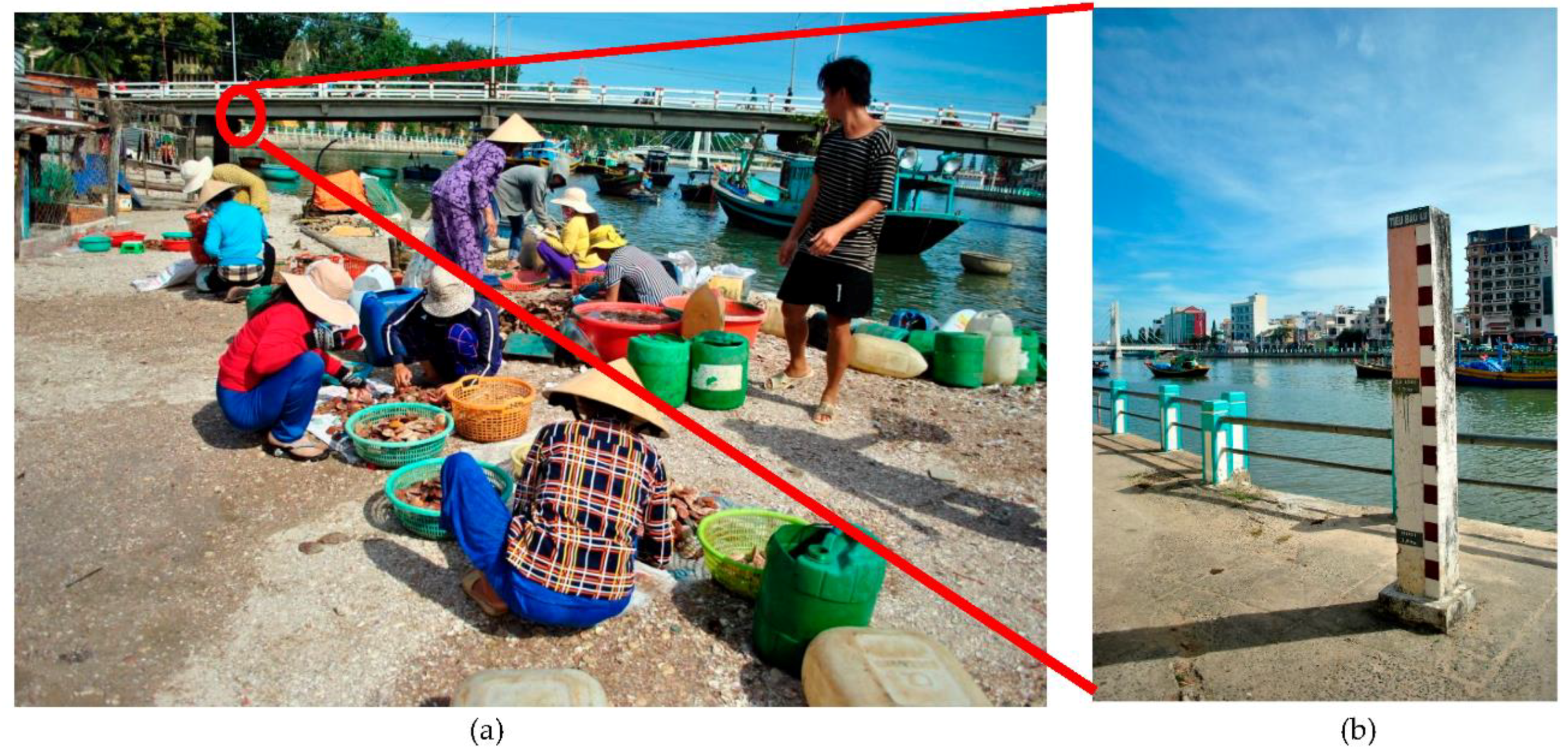
Phan Thiet is located in the province of Binh Thuan. However, the assessed wards are both located within the city of Phan Thiet and have different land elevations. Based on the projections of the MoNRE, the temperatures in Binh Thuan’s will increase by 0.7 °C, 90% CI [0.4, 1.2] by the early 21st century (2016–2035). Rainfall in the area is also expected to increase by 14.1%, 90% CI [5.9, 22.0] in the same period, while in terms of sea water levels, the region is expected to experience an increase of 12 cm, 90% CI [8,18]. Considering Phu Trinh’s very low land elevation (see Figure 4a,b), the site was assessed to have a high exposure to both sea level rise as well as in changes in annual rainfall. On the other hand, Duc Long was rated as moderate regarding the change in annual rainfall and sea level rise, mainly because of its higher elevation and given the range of protective infrastructures built along the coastline. The exposure levels in both wards are summarized in Table 7.

3.2. Characteristics of Fishery Sector

Both wards show a high dependence on fisheries, both for their daily protein intake and as a source of income. However, one of the main differences between Phu Trinh and Duc Long is the type of fishing methods that they use. Fishermen from Phu Trinh use a mix of mobile and fixed type of gears to harvest shells, while those from Duc Long make use exclusively of mobile fishing gears for catching pelagic fish, such as tunas and sardines. In Phu Trinh ward the majority of respondents have been engaged in fishing for over twenty years, while those in Duc Long have typically only been fishing for 10–20 years. In addition, family members, although not directly involved in fishing, were often found to be indirectly engaged in the sector, for example by selling fish in informal markets.
Nevertheless, the findings from the questionnaire surveys indicate that most residents of Phu Trinh ward do not live below the Vietnamese poverty line (1.3 million Vietnamese Dong (VND) per month), which contradicts the perception of key informant interviewees from the Phan Thiet city government. Respondents in both wards were able to make between 4,000,000–8,000,000 VND per month, a value higher that indicated by key informant interviews. However, it should be noted that although the study was able to collect data regarding monthly income, it was not clear whether the answers from respondents represented their mean income level throughout the entire year, as catch rates can differ according to the season. Risks tend to be higher for the poorest sector of the society [36] and it is important to carefully consider how to interpret these results regarding income.
Boat ownership was seen as one of the factors contributing to the disparity in income within the area. It was found that in Phu Trinh boat owners collect half of the earnings of the daily catch, with 5% of it going to pay for fuel costs. However, for the case of those involved in commercial fishing in the Duc Long ward boat owners take all of the earnings of the boat, with the fishermen collecting a payment for their labor based on the catch.

3.3. Demographics and Government Support

The socio-demographic data for the survey questionnaires is presented in Table 8 showing majority of respondents being male and has not attended any formal education.
Both wards are densely populated, though the majority of respondents indicated that they had not been involved in any project related to fisheries management by the government. Aside from the perceived lack of government support, their capacity to adapt to climate change impacts is probably affected by their lack of education. In both cases, almost 50% of the population had spent less than ten years in school and started getting involved in the fishing industry from an early age.

3.4. Results of Government Meeting

In an interview with key informants at the Phu Trinh ward office it was found that “climate change was treated as a small problem”, where only 3–5 million VND (130–220 USD) is being allocated for indirect adaptation measures. However, historical data obtained through the Emergency Events Database (EM-DAT), Binh Thuan province, shows that Phu Trinh has experienced major disasters in the past such as a flooding event in 1998 due to Tropical Storms Chip, Elvis and Dawn [41]. During site visits the authors observed markers on the side of the river showing that fluvial floods were 3 m deep in the past (see Figure 3). Despite this, to accommodate the continued growth in population in the Phu Trinh ward, the community has been unconsciously expanding its land area with the use of sea shells from the fishermen’s harvest [29].

3.5. Summary of Sensitivity and Lack of Adaptive Capacity Scores

Results of the sensitivity and lack of adaptive capacity scores were mainly gathered through the household surveys. Table 9 and Table 10 show the summaries of the Sensitivity and Lack of Adaptive Capacity Scores, respectively, for each of the two wards. Essentially, both wards can be seen to have a moderate sensitivity and high lack of adaptive capacity, which is not entirely surprising given that they are both in close proximity and that the socio-economic reality of both communities is not that different.

3.6. Relative Vulnerability

As a result of combining the Exposure, Sensitivity and Lack of Adaptive Capacity scores for both Phu Trinh and Duc Long (See Table 7, Table 9 and Table 10), the vulnerability to each of the climate change variables was identified (Table 11). The determination of vulnerability levels used the rules set by Licuanan et al.: (1) If at least one component is moderate, the vulnerability should be moderate; (2) if two components have at least moderate levels and the third has a high level, vulnerability should be set as high; (3) Otherwise, low vulnerability is given to the site [24].
In summary, both wards show high vulnerability to all the climate change variables identified in this study, with the difference that Phu Trinh has a high vulnerability to sea level rise and change in annual rainfall due to its extremely low land elevation and Duc Long having a moderate exposure. Although there is no difference between the levels of vulnerability for the two wards, average scores for sensitivity and lack of adaptive capacity can give an insight on the strength and weaknesses of a ward when elaborating strategies to attempt to adapt to changes in the environment.

4. Discussion

The present research aimed to quantify the social vulnerability of fishing communities in Vietnam to climate change and sea level rise. It focused on social vulnerability, as a function of climate change impacts and its effect to individuals [42]. The research enhances previous vulnerability assessments, as it engages local stakeholders and climate change experts, which increases the confidence levels in assessing local climate sensitivities [43].
The assumption of the tool is that the indicators identified hold equal weight. Following the framework developed by the IPCC in 2001 and Allison et al. [2], the three components were treated separately. It emphasizes that the capacity to adapt does not negate the “potential impact” defined by Allison et al. as the combination of Exposure and Sensitivity [2], essentially assuming that there is an equal interrelationship between the three components.
It is envisioned that this tool, in the same way in which the I-C-SEA Change [24] was built, will allow non-specialists to identify areas of concern, in order to improve the formulation of adaptation strategies. The difference between the I-C-SEA Change and this study is that it allowed a participatory vulnerability assessment by stakeholders through the implementation of a survey tool. This will recognize not only the awareness of the community regarding climate change but will also provide an overview of the different factors affecting their opinion towards its impacts [44]. In addition, in terms of the future decision making process by the local governments, using the proposed tool would enable an in-depth analysis of the area. In a study by Bulla et al. in 2017, it was found that the first concern of officials from coastal areas relate to water resources [45]. Using this tool would thus enhance the understanding of local officials of the complex variables affecting the socio-economic vulnerability of the area. The dependence on a certain resource extraction, such as fishing, as a source of livelihood is key to understanding the effects of climate change to local communities.
In addition, despite the uncertainties and limitations of using regional and national data in projecting the level of exposure to climate change impacts, this study provides a commune-specific vulnerability assessment tool that can promote a bottom-up planning process. By incorporating the land elevation in determining the exposure of an area to changes in annual precipitation and sea level rise, the national data that was developed by the MoNRE was further downscaled, from provincial to ward level. This presents a huge enhancement of existing vulnerability assessment tools, as it directly equates data on land elevation to future climate change projections in a simple manner. It is envisioned that this will enable the local government to share their knowledge with the national government and vice versa, increasing the capacity of the wards to manage climate-related data for adaptation plans. Much more important is the integration of this tool to broader disaster management plans and coastal zone management in Vietnam.
The results show that both areas have a high vulnerability to the impacts of climate change. Natural barriers (such as coral reefs, seagrass and mangroves) were not present in the study areas studies, which were essentially formed of low-lying communities with moderate to high sensitivity, due to their dependence on fisheries. The lack of adaptive capacity, which appears to stem from an absence of local government support, further increases the vulnerability of the area. As budget allocation for adaptation and mitigation is highly centralized, an increase in community engagement in developing climate change policies is needed in order to come up with effective solutions.
With fishing efforts expected to continue increasing over the next years, the risk of further damaging the environment will make it more difficult to address the impacts of climate change, especially if aggravated by other threats such as solid waste management and unsustainable coastal development.

5. Conclusions

The tool presented in this study provides an integration of biophysical, social and economic indicators to evaluate the relative vulnerability of fishing communities in Southern Vietnam. The methodology was developed to promote a rapid and convenient approach when determining collective values to identified indicators. The data that gathered was useful to determine the challenges faced by low-lying communities to the impending effects of climate change, such as sea level rise and changes in temperatures and rainfall.
The study thus provides a useful tool for helping local governments prioritize areas where adaptation programs should be formulated. In Vietnam, this constitutes a first attempt to simplify the means of quantitatively determining the overall vulnerability of fishing communities, which should be helpful in guiding decision makers in creating policies and programs on climate change adaptation and mitigation (i.e., allocation of funds, etc.). Moreover, the present tool can also be used to enhance current programs by engaging local communities in dialogues and focus group discussions.
Considering there is a continuous increase in fish meat dependency globally and in Vietnam, it is recommended that the tool is further tested and applied to other coastal communities in the country, so that it can be replicated at different temporal and spatial scales. With climate models getting more detailed, efforts should be put into incorporating social and economic factors to harmonize and mainstream local policies based on the results of climate change vulnerability assessments.

Author Contributions

Conceptualization, J.E.A., R.N.C., V.P.V., M.G.N.O., M.A.T.P., N.D.T., M.E.; Methodology, J.E.A., R.N.C., V.P.V., M.G.N.O., M.A.T.P., M.E.; Validation, J.E.A., R.N.C., N.D.T., M.E.; Formal analysis, J.E.A., R.N.C., V.P.V., M.G.N.O., M.A.T.P., N.D.T., M.E.; Investigation, J.E.A., R.N.C., V.P.V., M.G.N.O., M.A.T.P., N.K., D.H.A., P.C.V., H.D.B., N.H.P.T., M.T.Y.L., P.T.P.H., N.D.T., M.E.; Resources, J.E.A., N.D.T., M.E.; Data curation, J.E.A., M.G.N.O., M.A.T.P.; Writing—original draft preparation, J.E.A., R.N.C., M.G.N.O., M.A.T.P., M.E.; Writing—review and editing, J.E.A., R.N.C., V.P.V., N.D.T., M.E.; Visualization, J.E.A., R.N.C., M.E.; Supervision, R.N.C., N.D.T., M.O., M.E.; Project administration, J.E.A., R.N.C., N.D.T., M.O., M.E.; Funding acquisition, N.D.T., M.O., M.E.

Funding

The present research was funded by the Japanese Ministry of Education, Culture, Sports and Technology (Mombukagakusho), through its scheme on “Program for Leading Graduate Schools”, and the Japanese International Development Agency (JICA), through its funding of the Vietnam Japan University. The APC was funded by Waseda University.

Acknowledgments

The present research is the result of cooperation among three universities—The University of Tokyo, Ho Chi Minh City University of Technology and Vietnam Japan University, under the Global Field Exercise (GFE) course initiated by the Graduate Program in Sustainability Science-Global Leadership Initiative (GPSS-GLI), the University of Tokyo. The role of the Japanese Ministry of Education, Culture, Sports and Technology (Mombukagakusho), through its scheme on “Program for Leading Graduate Schools” and the Japanese International Development Agency (JICA) is thus greatly acknowledged. A part of the present work was performed as a part of activities of Research Institute of Sustainable Future Society, Waseda Research Institute for Science and Engineering, Waseda University.

Conflicts of Interest

The authors declare no conflict of interest.

References

  1. Gupta, J. Climate change and development cooperation: Trends and questions. Curr. Opin. Environ. Sustain. 2009, 1, 207–213. [Google Scholar] [CrossRef]
  2. Allison, E.H.; Perry, A.L.; Badjeck, M.C.; Nei Adger, W.; Brown, K.; Conway, D.; Halls, A.S.; Pilling, G.M.; Reynolds, J.D.; Andrew, N.L.; et al. Vulnerability of national economies to the impacts of climate change on fisheries. Fish Fish. 2009, 10, 173–196. [Google Scholar] [CrossRef] [Green Version]
  3. FAO. The State of World Fisheries and Aquaculture; FAO: Rome, Italy, 2009; Volume 35. [Google Scholar]
  4. Takagi, H.; Thao, N.D.; Esteban, M. Tropical Cyclones and Storm Surges in Southern Vietnam; Elsevier Inc.: Amsterdam, The Netherlands, 2014. [Google Scholar]
  5. Thang, N.T. Policy on Climate Change in Vietnam. In Proceedings of the 2nd International Conference on Sustainability Science in Asia (ICSS-Asia), Hanoi, Vietnam, 2–4 March 2011. [Google Scholar]
  6. Thuc, T. National Target Program to Respond to Climate Change; APAN: Hanoi, Vietnam, 2016. [Google Scholar]
  7. Hanh, T.; Furukawa, M. Impact of sea level rise on coastal zone of Vietnam. Bull. Coll. Sci. 2007, 84, 45–59. [Google Scholar]
  8. Kopp, R.E.; DeConto, R.M.; Bader, D.A.; Hay, C.C.; Horton, R.M.; Kulp, S.; Oppenheimer, M.; Pollard, D.; Strauss, B.H. Evolving Understanding of Antarctic Ice-Sheet Physics and Ambiguity in Probabilistic Sea-Level Projections. Earth’s Future 2017, 5, 1217–1233. [Google Scholar] [CrossRef] [Green Version]
  9. le Bars, D.; Drijfhout, S.; de Vries, H. A high-end sea level rise probabilitic projection including rapid Antarctic ice sheet mass loss. Environ. Res. Lett. 2017, 12, 044013. [Google Scholar] [CrossRef]
  10. Takagi, H.; Thao, N.D.; Esteban, M.; Mikami, T.; van Cong, L.; Ca, V.T. Handbook of Coastal Disaster Mitigation for Engineers and Planners; Elsevier: Woburn, UK, 2015; pp. 235–255. [Google Scholar]
  11. Knutson, T.R.; Tuleya, R.E. Impact of CO2-induced warming on simulated hurricane intensity and precipitation: Sensitivity to the choice of climate model and convective parameterization. J. Clim. 2004, 17, 3477–3495. [Google Scholar] [CrossRef]
  12. Nakamura, R.; Shibayama, T.; Esteban, M.; Iwamoto, T. Future Typhoon and Storm Surges Under Different Global Warming Scenarios: Case Study of Typhoon Haiyan (2013); Springer: Dordrecht, The Netherlands, 2016; Volume 8. [Google Scholar]
  13. Knutson, T.R.; McBride, J.L.; Chan, J.; Emanuel, K.; Holland, G.; Landsea, C.; Held, I.; Kossin, J.P.; Srivastava, A.K.; Sugi, M. Tropical Cyclones and Climate Change. Nat. Geosci. 2010, 3, 157–163. [Google Scholar] [CrossRef] [Green Version]
  14. Stromberg, P.M.; Esteban, M.; Gasparatos, A. Climate change effects on mitigation measures: The case of extreme wind events and Philippines’ biofuel plan. Environ. Sci. Policy 2011, 14, 1079–1090. [Google Scholar] [CrossRef]
  15. Esteban, M.; Thao, N.D.; Takagi, H.; Shibayama, T. Increase in Port Downtime and Damage in Vietnam Due to a Potential Increase in Tropical Cyclone Intensity. In Climate Change and the Sustainable Use of Water Resources; Springer: Berlin/Heidelberg, Germany, 2012. [Google Scholar]
  16. Imamura, F.; To, D. Flood and Typhoon Disasters in Viet Nam in the Half Century since 1950. Nat. Hazards 2017, 15, 45–59. [Google Scholar]
  17. Takagi, H.; Kashihara, H.; Esteban, M.; Shibayama, T. Assessment of Future Stability of Breakwaters under Climate Change. Coast. Eng. J. 2011, 53, 21–39. [Google Scholar] [CrossRef]
  18. Gledhill, D.; NOAA; White, M.; Salisbury, J.; Thomas, H.; Misna, I.; Liebman, M.; Mook, B.; Grear, J.; Candelmo, A.; et al. Ocean and Coastal Acidification off New England and Nova Scotia. Oceanography 2015, 25, 182–197. [Google Scholar] [CrossRef] [Green Version]
  19. Schmutter, K.; Nash, M.; Dovey, L. Ocean acidification: Assessing the vulnerability of socioeconomic systems in Small Island Developing States. Reg. Environ. Chang. 2017, 17, 973–987. [Google Scholar] [CrossRef]
  20. IFAD. Climate Change Analysis and Adaptation Responses; IFAD: Rome, Italy, 2012. [Google Scholar]
  21. Hinkel, J.; Klein, R.J.T. Integrating Knowledge for Assessing Coastal Vulnerability to Climate Change. In Manage Coastal Vulnerability Integrated Approach; Elsevier Inc.: Amsterdam, The Netherlands, 2007; pp. 1–20. [Google Scholar]
  22. Lins-de-Barros, F.M. Integrated coastal vulnerability assessment: A methodology for coastal cities management integrating socioeconomic, physical and environmental dimensions—Case study of Região dos Lagos, Rio de Janeiro, Brazil. Ocean Coast. Manag. 2017, 149, 1–11. [Google Scholar] [CrossRef]
  23. Nguyen, T.T.X.; Bonetti, J.; Rogers, K.; Woodroffe, C.D. Indicator-based assessment of climate-change impacts on coasts: A review of concepts, methodological approaches and vulnerability indices. Ocean Coast. Manag. 2016, 123, 18–43. [Google Scholar] [CrossRef] [Green Version]
  24. Licuanan, W.Y.; Samson, M.S.; Mamauag, S.S.; David, L.T.; Rosario, R.B.; Quibilan, M.C.C.; Siringan, F.P.; Maria, M.Y.Y.S.; España, N.B.; Villanoy, C.L. I-C-SEA Change: A participatory tool for rapid assessment of vulnerability of tropical coastal communities to climate change impacts. Ambio 2015, 44, 718–736. [Google Scholar] [CrossRef] [PubMed] [Green Version]
  25. WWF-South Pacific Programme. Climate Witness Community Toolkit; WWF South Pacific: Suva, Fiji, 2009. [Google Scholar]
  26. Maynard, J.A.; Marshall, P.A.; Johnson, J.E.; Harman, S. Building resilience into practical conservation: Identifying local management responses to global climate change in the southern Great Barrier Reef. Coral Reefs 2010, 29, 381–391. [Google Scholar] [CrossRef]
  27. Tompkins, E.L.; Adger, W.N. Does Adaptive Management of Natural Resources Enhance Resilience to Climate Change? Ecol. Soc. 2004, 9, 10. [Google Scholar] [CrossRef]
  28. Knaepen, H.L. 17 Mainstreaming Climate Change Adaptation into Vietnamese Development as a New Policy Arrangement; Elsevier Inc.: Amsterdam, The Netherlands, 2014. [Google Scholar]
  29. Esteban, M.; Takagi, H.; Valenzuela, V.P.; Thao, N.D.; Tam, T.T.; Trang, D.D.T.; Anh, L.T. Awareness of Coastal Disasters: Case of an Impoverished Low-Lying River Mouth Community in Southern Vietnam. Int. J. Sustain. Future Hum. Secur. 2017, 5, 77–85. [Google Scholar] [CrossRef]
  30. IPCC. Annex II: Glossary. In Climate Change 2014: Synthesis Report. Contribution of Working Groups I, II and III to the Fifth Assessment Report of the Intergovernmental Panel on Climate Change; Mach, K.J., Planton, S., von Stechow, C., Eds.; IPCC: Geneva, Switzerland, 2014; pp. 117–130. [Google Scholar]
  31. Adger, W.N. Social and ecological resilience: Are they related? Prog. Hum. Geogr. 2000, 24, 347–364. [Google Scholar] [CrossRef]
  32. MoNRE. Climate Change, Sea Level Rise Scenarios for Viet Nam: Summary for Policymakers; MoNRE: Hanoi, Vietnam, 2016; p. 37.
  33. Esteban, M.; Takagi, H.; Shibayama, T. Handbook of Coastal Disaster Mitigation for Engineers and Planners; Butterworth-Heinemann (Elsevier): Oxford, UK, 2015. [Google Scholar]
  34. Jamero, M.L.; Onuki, M.; Esteban, M.; Tan, N. Community-based adaptation in low-lying islands in the Philippines: Challenges and lessons learned. Reg. Environ. Chang. 2018, 18, 2249–2260. [Google Scholar] [CrossRef]
  35. Takagi, H.; Fujii, D.; Esteban, M.; Yi, X. Effectiveness and Limitation of Coastal Dykes in Jakarta: The Need for Prioritising Actions against Land Subsidence. Sustainability 2017, 9, 619. [Google Scholar] [CrossRef]
  36. Takagi, H.; Esteban, M.; Tam, T.T. Coastal Vulnerabilities in a Fast-Growing Vietnamese City; Elsevier Inc.: Amsterdam, The Netherlands, 2014. [Google Scholar]
  37. Ding, Q.; Chen, X.; Hilborn, R.; Chen, Y. Vulnerability to impacts of climate change on marine fisheries and food security. Mar. Policy 2017, 83, 55–61. [Google Scholar] [CrossRef]
  38. MARD; FAO. Vietnam Country Programming Framework 2012–2016; MARD; FAO: Hanoi, Vietnam, 2013; p. 55. [Google Scholar]
  39. Muallil, R.N.; Geronimo, R.C.; Cleland, D.; Cabral, R.B.; Doctor, M.V.; Cruz-Trinidad, A.; Aliño, P.M. Willingness to exit the artisanal fishery as a response to scenarios of declining catch or increasing monetary incentives. Fish. Res. 2011, 111, 74–81. [Google Scholar]
  40. Salik, K.M.; Jahangir, S.; Zahdi, W.Z.; Hasson, S. Climate change vulnerability and adaptation options for the coastal communities of Pakistan. Ocean Coast. Manag. 2015, 112, 61–73. [Google Scholar] [CrossRef]
  41. CRED. EM-DAT: The International Disaster Database. 2018. Available online: www.emdat.be/database (accessed on 11 September 2018).
  42. Chambers, R. Vulnerability, coping and policy (editorial introduction). IDS Bull. 2006, 37, 33–40. [Google Scholar] [CrossRef] [Green Version]
  43. Yoo, G.; Hwang, J.H.; Choi, C. Development and application of a methodology for vulnerability assessment of climate change in coastal cities. Ocean Coast. Manag. 2011, 54, 524–534. [Google Scholar] [CrossRef]
  44. Smit, B.; Wandel, J. Adaptation, adaptive capacity and vulnerability. Glob. Environ. Chang. 2006, 16, 282–292. [Google Scholar] [CrossRef]
  45. Bulla, B.R.; Craig, E.A.; Steelman, T.A. Climate change and adaptive decision making: Responses from North Carolina coastal officials. Ocean Coast. Manag. 2017, 135, 25–33. [Google Scholar] [CrossRef]
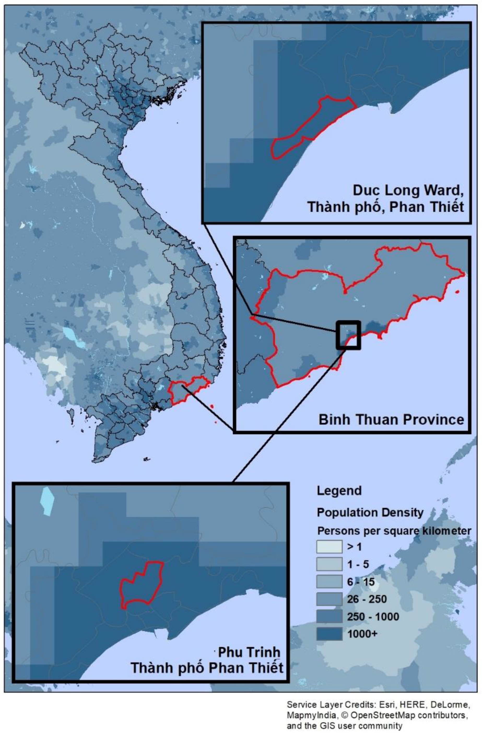
Figure 1. Map of the Binh Thuan Province, showing the location of Phu Trinh Ward and Duc Long Ward.
Geosciences 08 00452 g001
Figure 2. Members of Phu Trinh-Phan Thiet sorting their fish catch.
Geosciences 08 00452 g002
Figure 3. Fishing vessels in the Duc Long port.
Geosciences 08 00452 g003
Figure 4. (a) Phu Trinh is located next to the river just above water level (b) Flood marker located at an elevated road at the side of the river, showing historical flooding occurrence in the area (much higher than the level of the ground in the left side photograph).
Geosciences 08 00452 g004
Table 1. Scoring rubric used for assigning the exposure levels using the “early” 21st century (2016–2035) climate scenarios (after MoNRE, 2016).
Climate Change VariableRange given for the RCP 4.5 Climate ScenarioExposure Score Thresholds
Change in annual temperature0.6 to 0.8 °CLow 0.6–0.69 °C
Moderate 0.7–0.79 °C
High >0.8 °C
Change in annual Rainfall1.8 to 24.4%Low 1.8–9.2%
Moderate 9.3–16.9%
High 17.0–24.4%
Sea level rise12 to 14 cmLow land elevation (0.0–0.49 m)
Moderate 0.5–1.99 m
High land elevation >1.99 m
Land elevation of areas identified.
Table 2. Influence on elevation and changes in annual rainfall on flooding risk.
ElevationElevation levelChange in Annual Rainfall
HighModerateLow
LowHighHighModerate
ModerateHighModerateModerate
HighLowLowLow
Table 3. Scoring rubric used for assigning the sensitivity scores of the indicators that were surveyed (n = 80).
CriteriaLowModerateHigh
1 Point2 Points3 Points4 Points5 Points
Type of fish100% pelagic fishes75% pelagic and 25% demersal fishes50% pelagic and 50% demersal fishes25% pelagic and 75% demersal fishes100% demersal fishes
Average Catch Rate>8 kg per day6–8 kg per day4–6 kg per day2–4 kg per day<2 kg per day
Fishing Gears100% mobile fishing gears75% mobile and 25% habitat-associated50% mobile and 50% habitat-associated25% mobile and 75% habitat-associated gears100% Habitat-associated gear
Dependence on Fishery as NutritionOnce a weekTwice a week3–4 times a week5–6 times a weekEveryday
Dependence to Fishing30% or less of the population are fishers31–40% of the population are fishers41–50% of the population are fishers50–60% of the population are fishersMore than 60% of the population are fishers
Table 4. Scoring rubric used assigning the sensitivity of the indicators that were observed.
CriteriaLowModerateHigh
1 Point2 Points3 Points4 Points5 Points
Population Density<100 persons/sq km2100–200 persons/sq km2Between 201 and 350 persons/sq km2Between 351 and 500 persons/sq km2More than 500 persons/sq km2
Change in LandHeavily accretingModerately accretingStableModerately erodingHeavily eroding
Proneness to erosion100% Rocky shore75% rocky 25% gravel shore50% rocky and 50% gravel shore25% gravel and 75% sandy shore100% sandy shore
Width of the Shore>100 m90–100 m70–89 m50–69 m<50 m
Table 5. Scoring rubric used for assigning the Lack of Adaptive Capacity scores of the surveyed indicators.
CriteriaLowModerateHigh
2 Point3 Points4 Points5 Points
Fishing Experience<5 YearsBetween 5 and 10 yearsBetween 10 and 20 years>20 Years
Additional Income Source+3 Livelihood Source+2 Livelihood Source+1 Livelihood SourceFishing as sole livelihood source
Fisheries Management EngagementMore than 60% of the population engagedBetween 40% and 60%Between 20% and 40%Less than 20%
EducationLess than 20% of the population has less than 10 years of schoolingBetween 20% and 40%Between 40% and 60%More than 60%
Table 6. Scoring rubric used for assigning the Lack of Adaptive Capacity scores for observed indicators.
CriteriaLowModerateHigh
2 Point3 Points4 Points5 Points
Solid Waste AccumulationNoSolid Waste accumulates for 0–4 months every yearSolid Waste accumulates for 5–11 months every yearSolid Waste accumulates all year round
Land UseIndustrialCommercialResidentialRural, fishing, agricultural
Local Climate Change Adaptation (CCA) PolicyComprehensive CCA Policy with enforcement meansComprehensive CCA Policy without enforcement meansOfficial commitment to create a local policyNon-existent
Climate DataExtensive scenario research: public access to general data: (all-scenarios approach)Single scenario research: public access to general dataBasic scenario researchNon-existent
CCA FundingClear-cut separate CC budgetNo separate CC budget: more than 50% funded by recipient country on CC projectsNo separate CC budget: more than 90% funded by recipient country on CC projectsNon-existent
Table 7. Exposure levels of the province of Binh Thuan.
Climate Change Variable
Change in Annual Temperature (2016–2035)AssessmentChange in Annual Rainfall Relative to Land ElevationAssessmentSea Level Rise Exposure Based on Land ElevationAssessment
Phu Trinh0.7 °CMODERATE14.1%, Low ElevationHIGH>0.49 cmHIGH
Duc Long0.7 °CMODERATE14.1%, Moderate ElevationMODERATE0.5–1.99mMODERATE
Table 8. Socio demographic data of the respondents of the questionnaire survey.
Phu TrinhDuc Long
SexMale:55%Male:73%
Female:45%Female:27%
Highest Educational AttainmentNo Formal Schooling: 46%No Formal Schooling: 45%
Primary School: 28%Primary School: 38%
High school Graduate: 18%High school Graduate: 18%
College Graduate: 17%College Graduate: 0%
Table 9. Summary of Sensitivity scores for the 2 wards of Phan Thiet.
Sensitivity
CriteriaPhu TrinhPointDuc LongPoint
Type of FishShells5Pelagic Fish (e.g., Tuna, Sardines, Mackerel)1
Average Catch RateMore than 8 kg a day1More than 8 kg a day1
Fishing GearsBoth types present3Mostly mobile fishing gears1
Dependence of Fishery as NutritionEveryday5Everyday5
Dependence to FishingMore than 60% are fishermen5More than 60% are fishermen5
Population Density13,333/sq.km.58371/sq.km.5
Change in LandModerately Accreting2Heavily Eroding5
Proneness to erosionGravel and Sand4Sandy5
Width of the Shore<50 m5>100m1
AVERAGE3.93.2
SENSITIVITY LEVELMODERATEMODERATE
Table 10. Summary Lack of Adaptive Capacity scores for the 2 wards of Phan Thiet.
Lack of Adaptive Capacity Criteria
CriteriaPhu TrinhPointsDuc LongPoints
Fishing ExperienceMore than 20 years5Between 10–20 years4
Additional Income SourceNone5None5
Fisheries Engagement38%415%5
Education74%583%5
Solid Waste AccumulationAll year round5All year round5
Land UseResidential4Commercial3
Local CCA PolicyNon-existent5Non-existent5
Climate DataBasic Scenario4Basic Scenario4
CCA FundingNo separate CC budget4No separate CC budget4
AVERAGE4.64.4
LACK OF ADAPTIVE CAPACITY LEVELHIGHHIGH
Table 11. Vulnerability of Phu Trinh and Duc Long wards to climate change variables.
Phu TrinhDuc Long
VulnerabilityExposureSensitivityLack of Adaptive CapacityVulnerabilityExposureSensitivityLack of Adaptive Capacity
Temperature
HighModerateModerateHighHighModerateModerateHigh
Rainfall
HighHighModerateHighHighModerateModerateHigh
Sea Level Rise relative to Land Elevation
HighHighModerateHighHighModerateModerateHigh