Evaluation of Exploitable Groundwater Reserves in Karst Terrain: A Case Study from Crete, Greece

Abstract
:1. Introduction
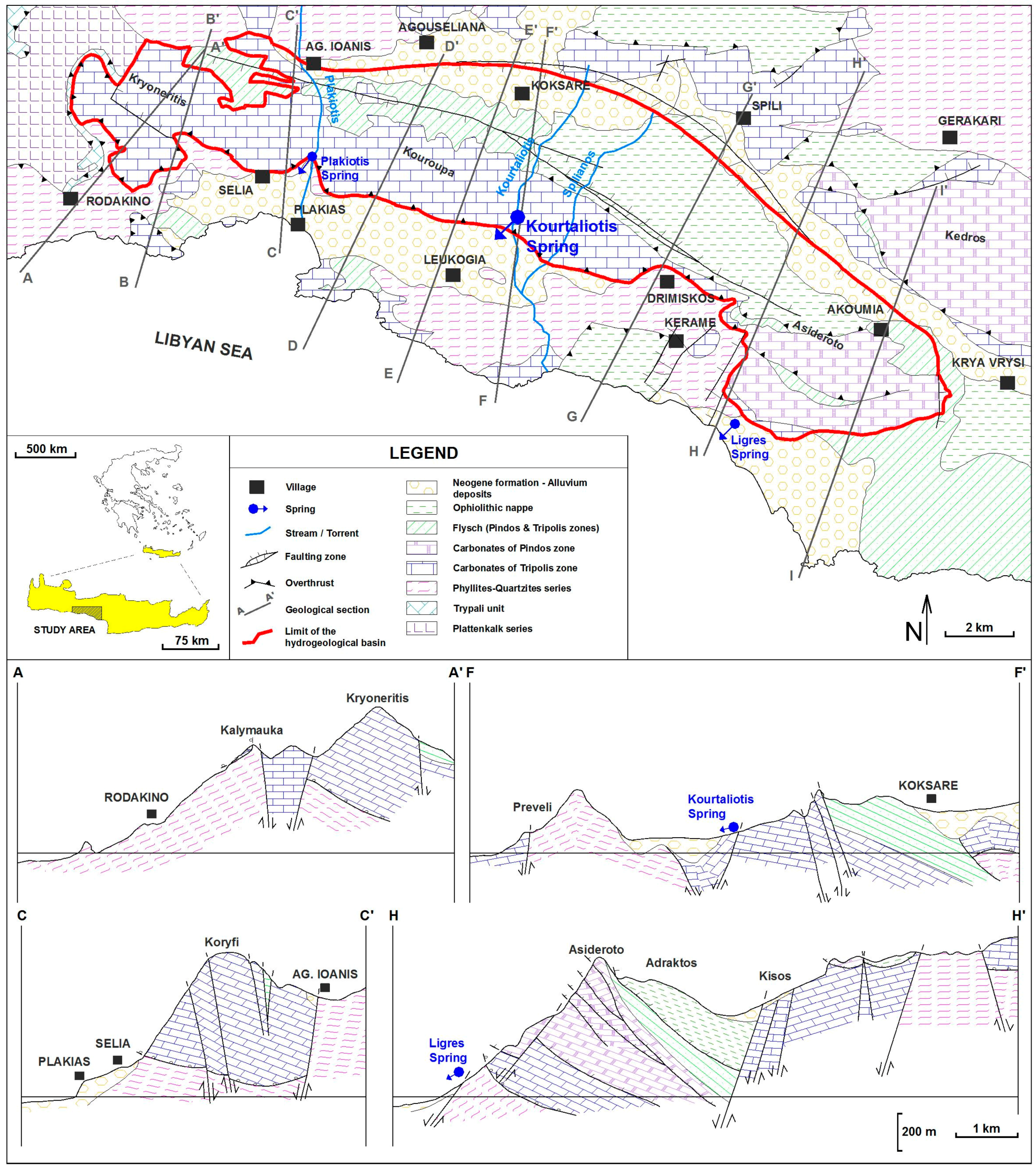
2. Geology
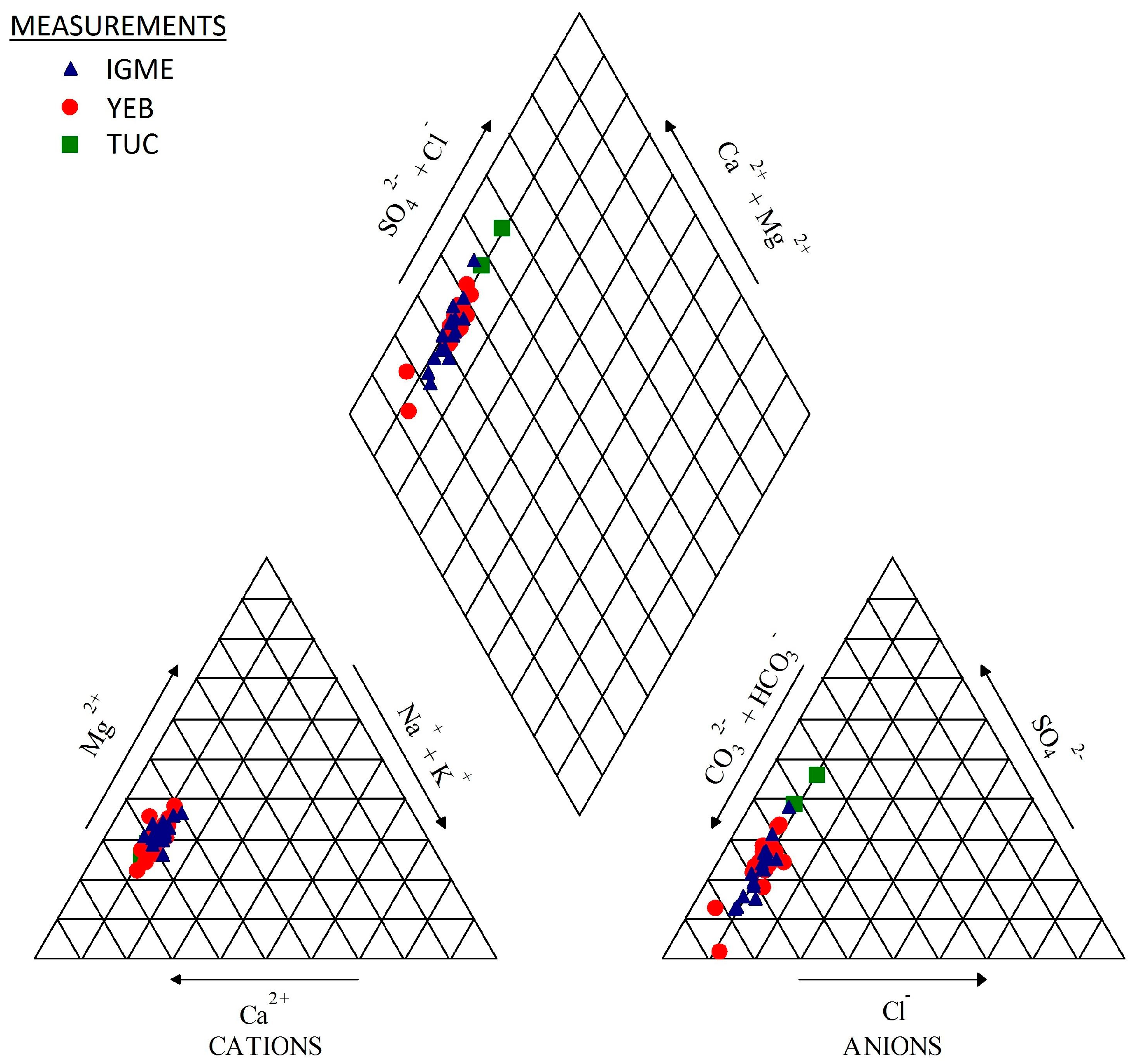
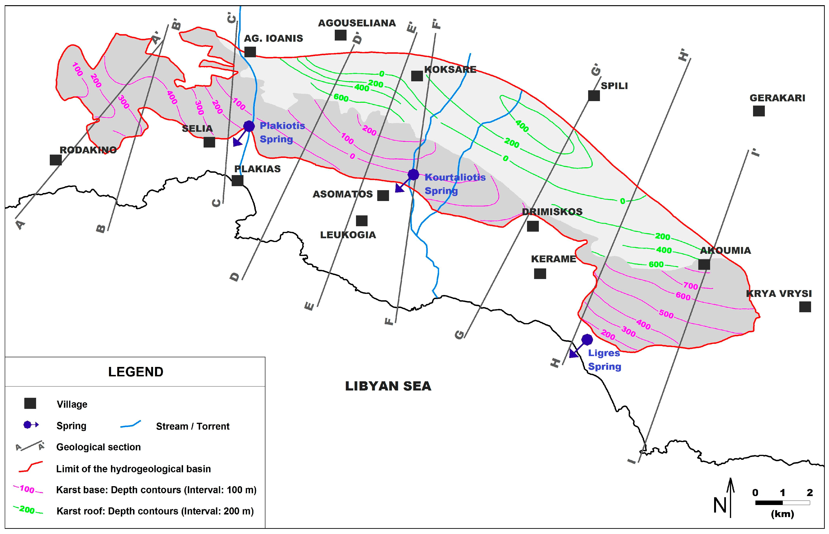
3. Hydrogeological Setting
4. Groundwater Reserves
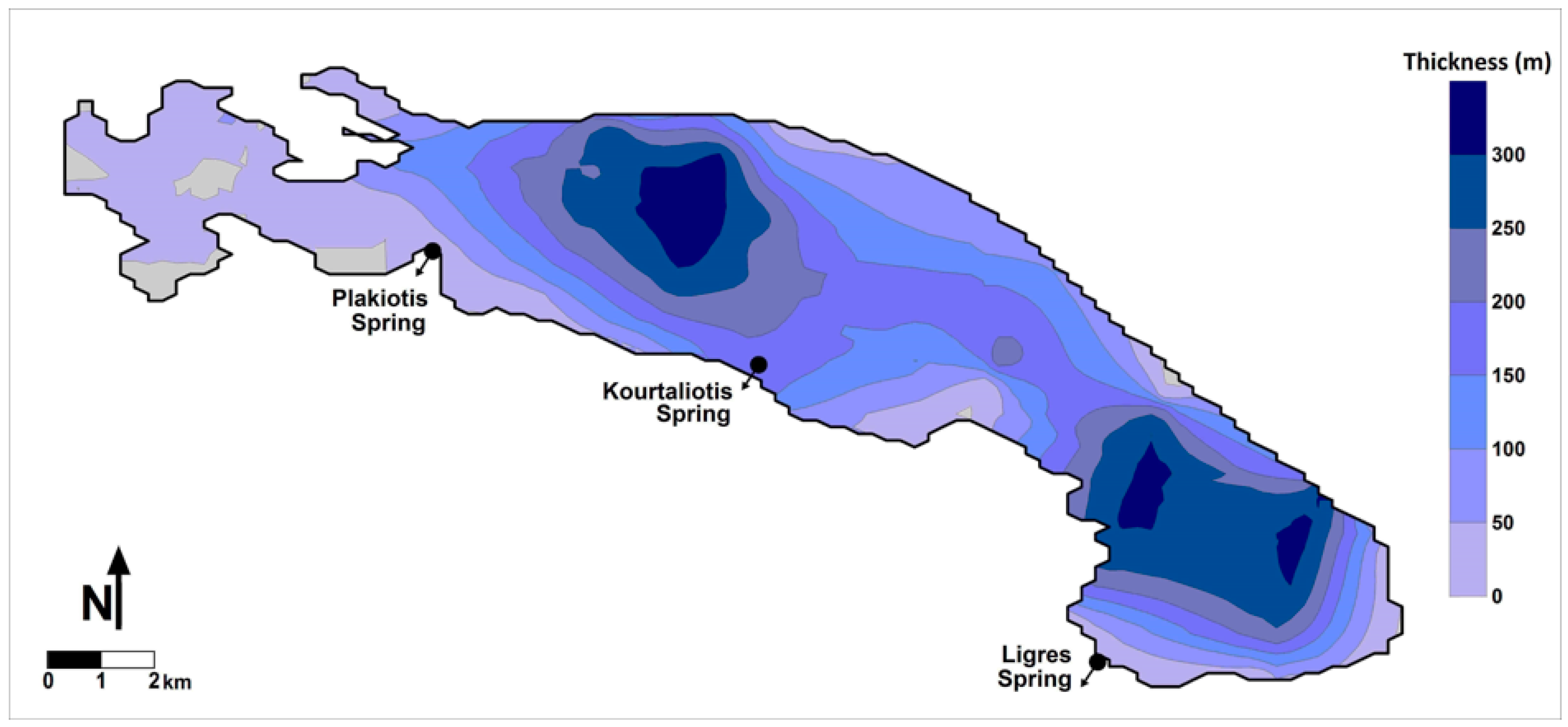
4.1. Assessment of Permanent and Dynamic Reserves Based on the Hydrogeological Framework of the Groundwater System
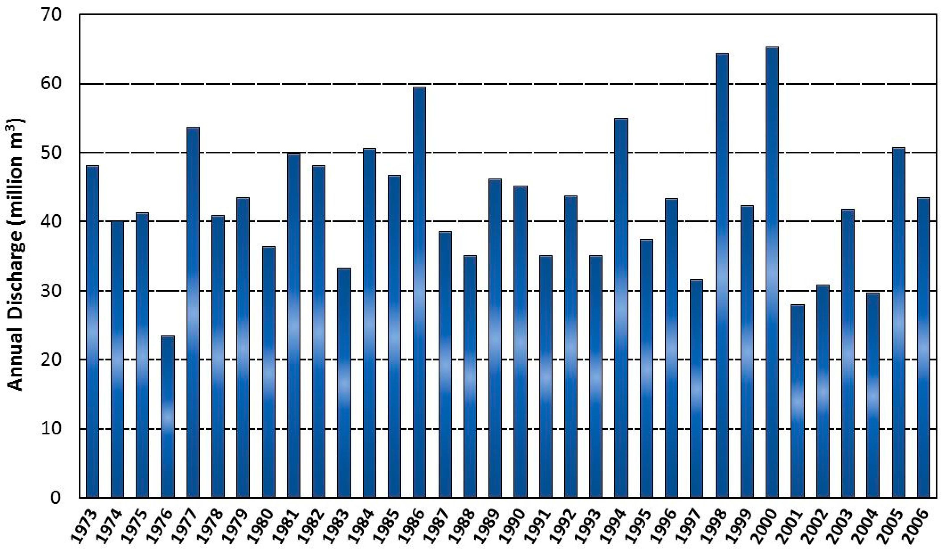
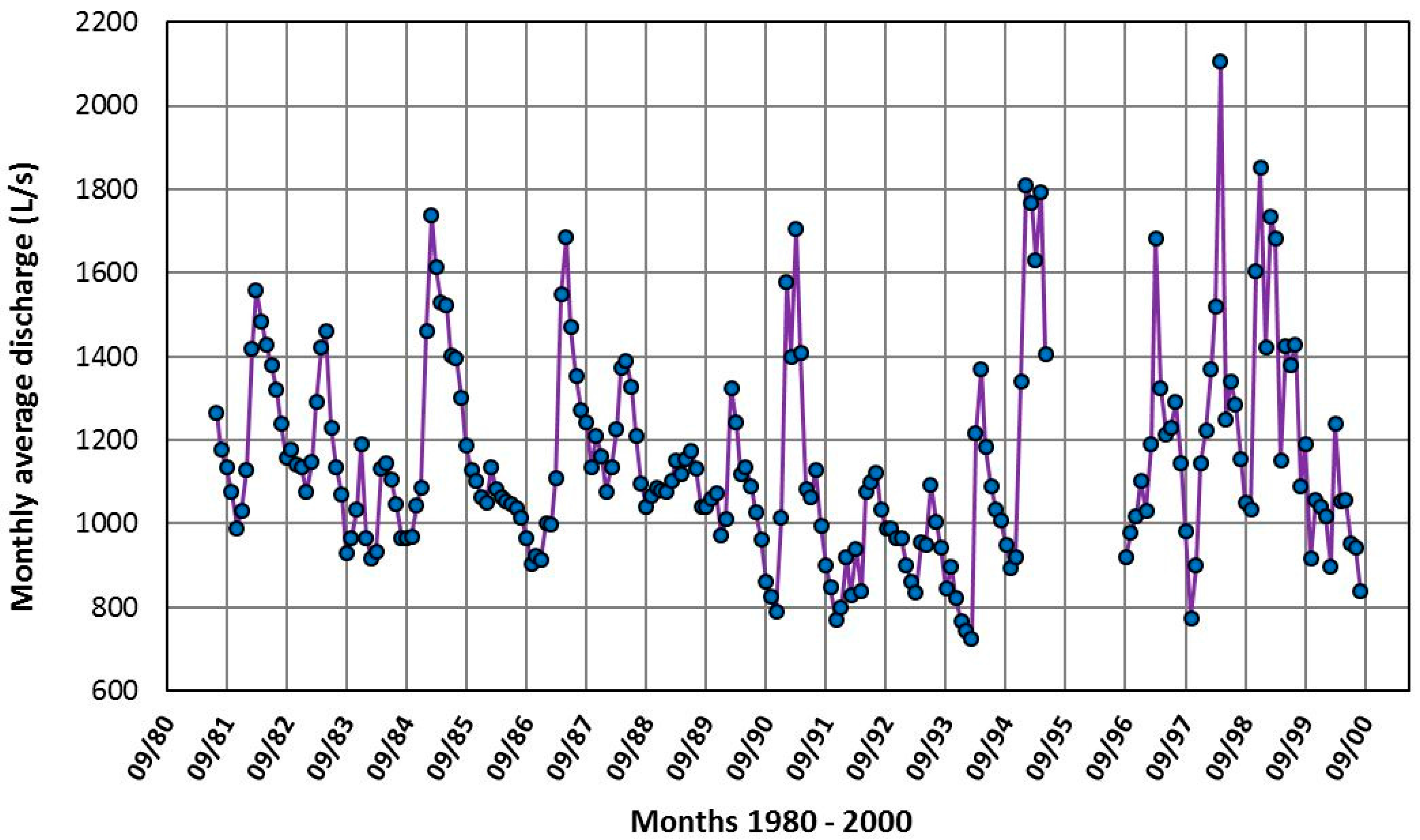
4.2. Evaluation of Aquifer Dynamic Reserves by Analyzing Recession Hydrographs
5. Discussion and Conclusions
Acknowledgments
Conflicts of Interest
References
- Jukić, D.; Denić-Jukić, V. Groundwater balance estimation in karst by using a conceptual rainfall–runoff model. J. Hydrol. 2009, 373, 302–315. [Google Scholar] [CrossRef]
- Fiorillo, F.; Vakanjac, V.R.; Jemcov, I.; Milanović, S.; Stevanović, Z. Karst groundwater availability and sustainable development. In Karst Aquifers—Characterization and Engineering; Springer: Berlin, Germany, 2015. [Google Scholar]
- Bonacci, O. Karst springs hydrographs as indicators of karst aquifers. Hydrol. Sci. J. 1993, 38, 51–62. [Google Scholar] [CrossRef]
- White, W.B. Karst hydrology: Recent developments and open questions. Eng. Geol. 2002, 65, 85–105. [Google Scholar] [CrossRef]
- Ginsberg, M.; Palmer, A. Delineation of Source water Protection Areas in Karst Aquifers of the Ridge and Valley and Appalachian Plateaus Physiographic Provinces: Rules of Thumb for Estimating the Capture Zones of Springs and Wells; U.S. Environmental Protection Agency: Washington, DC, USA, 2002.
- Ford, D.C.; Williams, P.W. Karst Hydrogeology and Geomorphology; Chapman & Hall: London, UK, 1989. [Google Scholar]
- Karakitsios, V. Geological Map of Greece: Sellia Sheet (Crete Island). Scale 1:50,000; Institute for Geology and Subsurface Research: Athens, Greece, 1982. [Google Scholar]
- Bonneau, M. Geological Map of Greece, Sheet Melampes. Scale 1:50,000; Institute for Geology and Subsurface Research: Athens, Greece, 1985. [Google Scholar]
- Krahl, J.; Kauffmann, G.; Richter, D.; Kozur, H.; Möller, I.; Förster, O.; Heinritzi, F.; Dornsiepen, U. Neue Fossilfunde in der Phyllit-Gruppe Ostkretas (Griechenland). Z. Deut. Geol. Ges. 1986, 137, 523–536. [Google Scholar]
- Pomoni-Papaioannou, F.; Karakitsios, V. Facies analysis of the Trypali carbonate unit (Upper Triassic) in central-western Crete (Greece): An evaporite formation transformed into solution-collapse breccias. Sedimentology 2002, 49, 1113–1132. [Google Scholar] [CrossRef]
- Karakitsios, V. Contribution À L’étude Géologique des Hellénides. Étude de La Région de Sellia (Crète Moyenne-occidentale, Grèce): Les Relations Lithostratigraphiques et Structurales Entre La Série des Phyllades et de la Série Carbonatée de Tripolitza. Ph.D. Thesis, University of Paris, Paris, France, 1979. [Google Scholar]
- Karakitsios, V. The lithostratigraphical, metamorphic and tectonic relations between Phyllite and Tripolis carbonate series in Middle-Western Crete. Bull. Geol. Soc. Greece 1986, 28, 31–58. [Google Scholar]
- Stampfli, G.; Champod, E.; Vandelli, A. Tectonostratigraphy and Plate Tectonics of Crete 2010. Available online: https://www.researchgate.net/publication/255964884_Tectonostratigraphy_and_plate_tectonics_of_Crete_2010 (accessed on 20 November 2017).
- Bakalowicz, M.; El Hakim, M.; El-Hajj, A. Karst groundwater resources in the countries of eastern Mediterranean: the example of Lebanon. Environ. Geol. 2008, 54, 597–604. [Google Scholar] [CrossRef]
- Bakalowicz, M.; Fleury, P.; Dörfliger, N.; Seidel, J.L. Coastal Karst Aquifers in Mediterranean Regions. A Valuable Ground Water Resource in Complex Aquifers. Available online: http://aguas.igme.es/igme/publica/tiac-01/Area%20I-15.pdf (accessed on 20 November 2017).
- Bakalowicz, M. Karst and karst groundwater resources in the Mediterranean. Environ. Earth. Sci. 2015, 74, 5–14. [Google Scholar] [CrossRef]
- Mijatović, B. The groundwater discharge in the Mediterranean karst coastal zones and freshwater tapping: Set problems and adopted solutions, case studies. Environ. Geol. 2007, 51, 737–742. [Google Scholar] [CrossRef]
- Papakis, N. Hydrogeological Study of St. George Kiveri Springs (Argolida); Institute for Geology and Subsurface Research: Athens, Greece, 1966. (In Greek) [Google Scholar]
- Monopolis, D.; Mastoris, K. Hydrogeological Study of the Karstic Brackish Spring of Almyros (Heraklion Crete); Hydrologic and Hydrogeological Researches of Institute for Geology and Subsurface Research: Athens, Greece, 1969. (In Greek) [Google Scholar]
- Mastoris, K.; Monopolis, D.; Skagias, S. Hydrogeological Survey of Corinth—Loutraki Area; Hydrologic and Hydrogeological Surveys of Institute for Geology and Subsurface Research: Athens, Greece, 1971. (In Greek) [Google Scholar]
- Meulenkamp, J.E. Field Guide to the Neogene of Crete; Department of Geology and Paleontology, University of Athens: Athens, Greece, 1979. [Google Scholar]
- Meulenkamp, J.E.; Van der Zwaan, G.J.; Van Wamel, W.A. On Late Miocene to recent vertical motions in the Cretan segment of the Hellenic arc. Tectonophysics 1994, 234, 53–72. [Google Scholar] [CrossRef]
- Peterek, A.; Schwarze, J. Architecture and Late Pliocene to recent evolution of outer-arc basins of the Hellenic subduction zone (south-central Crete, Greece). J. Geodyn. 2004, 38, 19–55. [Google Scholar] [CrossRef]
- TUC (Technical University Crete). Development of Exploitation Methods of the Underground Water in West Crete; Program for the Researchers Support Ministry of Industry, Research and Technology/General Secretariat for Research and Technology GGET: Chania, Greece, 1990. (In Greek) [Google Scholar]
- Steiakakis, E.; Monopolis, D.; Vavadakis, D.; Lambrakis, N. Effective infiltration assessment in Kourtaliotis karstic basin (S. Crete). In Proceedings of the 9th International Hydrogeological Congress, Kalavrita, Greece, 5–8 October 2011. [Google Scholar]
- Decentralized Administration of Crete. Status of Groundwater in Crete; Region of Crete, Directorate of Water, Department Monitoring and Control of Quality and Quantity of Water: Heraklion, Greek, 2013. (In Greek)
- Soulios, G. Springs (classification, function, capturing). In Proceedings of the 12th International Congress of the Geological Society of Greece, Patras, Greece, 19–22 May 2010. [Google Scholar]
- Stevanović, Z. Characterization of karst aquifer. In Karst Aquifers—Characterization and Engineering, Professional Practice in Earth Sciences; Springer: Berlin, Germany, 2015. [Google Scholar]
- Council Directive. Council Directive 98/83/EC of 3 November 1998 Relating to the Quality of Water Intended for Human Consumption; Official Journal of European Communities: Brussels, Belgium, 1988. [Google Scholar]
- ASTM D5923-96. Standard Guide for Selection of Kriging Methods in Geostatistical Site Investigations; ASTM International: West Conshohocken, PA, USA, 2004. [Google Scholar]
- Golden Software Inc. Surfer Quick Start Guide. Available online: http://downloads.goldensoftware.com/guides/SurferQSG.pdf (accessed on 20 November 2017).
- Oliveira, S.A.; Koppe, J.C.; Costa, J.F.C.L. Overburden volume estimation assisted by geostatistics in open cast coal mine. In International Journal of Rock Mechanics and Mining Sciences and Geomechanics Abstracts; Elsevier: Amsterdam, The Netherlands, 1996. [Google Scholar]
- Aronis, G.; Burdon, D.J.; Zeris, K. Development of a karst limestone spring in Greece. In Groundwater in Arid Zones; International Association of Hydrological Sciences: London, UK, 1961. [Google Scholar]
- Kessler, H. Water Balance Investigations in the Karst Regions of Hungary; Act Coll Dubrovnik, AIHS-UNESCO: Paris, France, 1967. [Google Scholar]
- Monopolis, D. Hydrogeological Study of the Karstic Carbonate Rocks in the Mt Paranssos Complex. Ph.D. Thesis, NTUA, Athens, 1971. (In Greek). [Google Scholar]
- Kounis, G.D.; Kounis, K.G. Infiltration, effective porosity, transmissibility and critical yield of water wells in the carbonate fissured aquifers of Attica—A contribution to the regional and managerial hydrogeology. Bulletin of the Geological Society of Greece. In Proceedings of the 12th International Congress of the Geological Society of Greece, Patras, Greece, 19–22 May 2010. [Google Scholar]
- Pérez, J.; Sanz, E. Hydrodynamic characteristics and sustainable use of a karst aquifer of high environmental value in the Cabrejas range (Soria, Spain). Environ. Earth. Sci. 2011, 62, 467–479. [Google Scholar] [CrossRef]
- Jukić, D.; Denić-Jukić, V. A frequency domain approach to groundwater recharge estimation in karst. J. Hydrol. 2004, 289, 95–110. [Google Scholar] [CrossRef]
- Raeisi, E. Ground-water storage calculation in karst aquifers with alluvium or no flow boundaries. J. Cave Karst Stud. 2008, 70, 62–70. [Google Scholar]
- Mijatović, B. A Method of Studying the Hydrodynamic Regime of Karst Aquifers by Analysis of the Discharge Curve and Level Fluctuation during Recession; Institute for Geological and Geophysical Research: Beograd, Serbia, 1970. [Google Scholar]
- Krešić, N. Groundwater Resources: Sustainability, Management, and Restoration; McGraw Hill Professional: New York, NY, USA, 2009. [Google Scholar]
- Dewandel, B.; Lachassagne, P.; Bakalowicz, M.; Weng, P.; Al-Malki, A. Evaluation of aquifer thickness by analysing recession hydrographs. Application to the Oman ophiolite hard-rock aquifer. J. Hydrol. 2003, 274, 248–269. [Google Scholar] [CrossRef]
- Özler, M.H. Water balance and water quality in the Çürüksu basin, western Turkey. Hydrogeol. J. 1999, 7, 405–418. [Google Scholar] [CrossRef]
- Bouloukakis, H.; Voudouris, K. Pumping test evaluation in Plattenkalk of Crete. In Proceedings of the 4th Hydrogeological Conference, Thessaloniki, Greek, 31 May–6 June 1997; pp. 324–336. [Google Scholar]
- Monopolis, D.; Sofiou, P.; Steiakakis, E.; Kadianakis, M.; Vavadakis, D.; Kleidopoulou, M. Determination of hydraulic parameters of carbonate rocks (Methodology, Statistical analysis). In Proceedings of the 5th Hellenic Hydrogeological Congress, Nicosia, Cyprus, 12–14 November 1999. (In Greek). [Google Scholar]
- Bechtel, T.; Bosch, F.; Gurk, M. Geophysical methods in karst hydrogeology. In Methods in Karst Hydrogeology; Taylor and Francis: London, UK, 2007. [Google Scholar]
- Stevanović, Z. Utilization and regulation of springs. In Groundwater Hydrology of Springs: Theory, Management, and Sustainability; Butterworth-Heinemann: Oxford, UK, 2010. [Google Scholar]
- Fleury, P.; Ladouche, B.; Conroux, Y.; Jourde, H.; Dörfliger, N. Modelling the hydrologic functions of a karst aquifer under active water management—The Lez spring. J. Hydrol. 2009, 365, 235–243. [Google Scholar] [CrossRef]
- Stevanović, Z.; Jemcov, I.; Milanović, S. Management of karst aquifers in Serbia for water supply. Environ. Geol. 2007, 51, 743–748. [Google Scholar] [CrossRef]


© 2018 by the author. Licensee MDPI, Basel, Switzerland. This article is an open access article distributed under the terms and conditions of the Creative Commons Attribution (CC BY) license (http://creativecommons.org/licenses/by/4.0/).
Share and Cite
Steiakakis, E. Evaluation of Exploitable Groundwater Reserves in Karst Terrain: A Case Study from Crete, Greece. Geosciences 2018, 8, 19. https://doi.org/10.3390/geosciences8010019
Steiakakis E. Evaluation of Exploitable Groundwater Reserves in Karst Terrain: A Case Study from Crete, Greece. Geosciences. 2018; 8(1):19. https://doi.org/10.3390/geosciences8010019
Chicago/Turabian StyleSteiakakis, Emmanouil. 2018. "Evaluation of Exploitable Groundwater Reserves in Karst Terrain: A Case Study from Crete, Greece" Geosciences 8, no. 1: 19. https://doi.org/10.3390/geosciences8010019
APA StyleSteiakakis, E. (2018). Evaluation of Exploitable Groundwater Reserves in Karst Terrain: A Case Study from Crete, Greece. Geosciences, 8(1), 19. https://doi.org/10.3390/geosciences8010019