Geospatial Analysis of Land Use and Land Cover Transitions from 1986–2014 in a Peri-Urban Ghana
Abstract
:1. Introduction
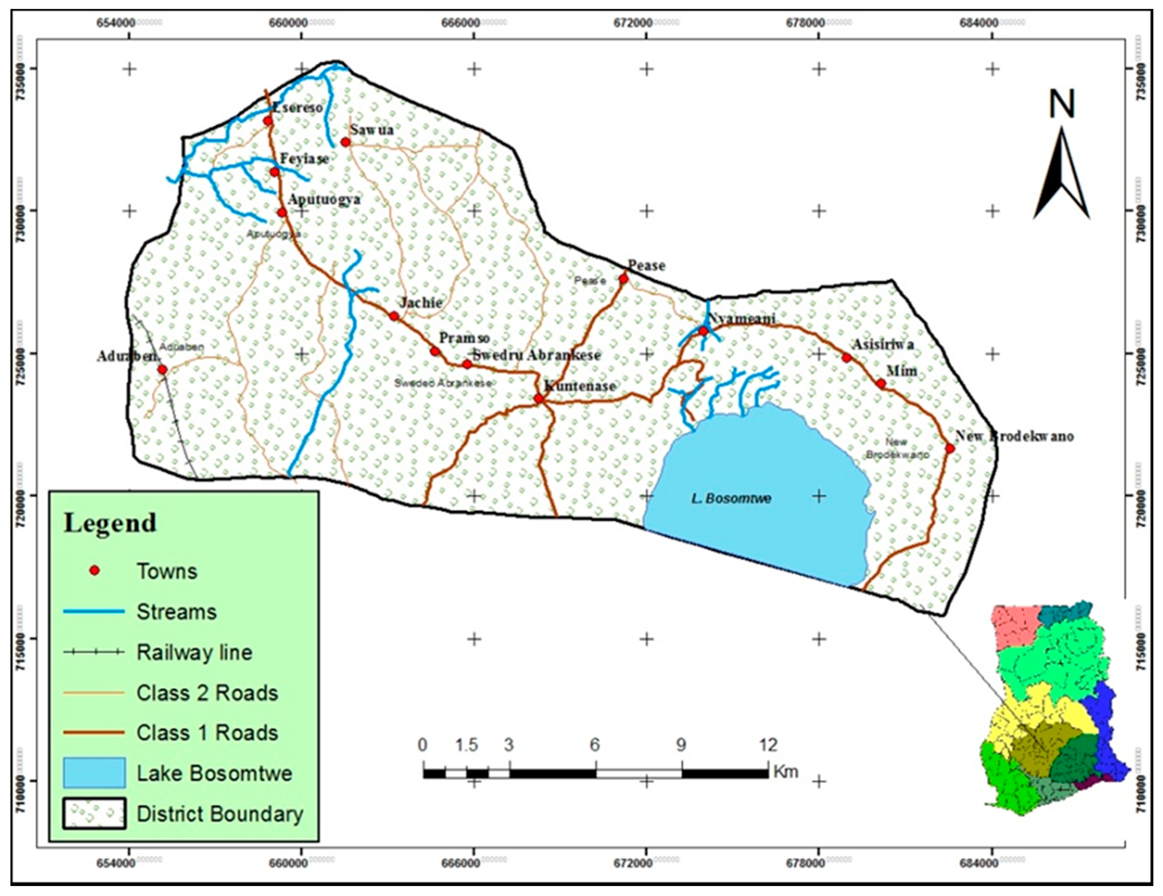
2. Description of the Study Area
3. Materials and Methods
3.1. Image Data, Classification and Change Detection
3.2. Post-Classification Accuracy Assessment
3.3. Land Use and Land Cover Dynamics
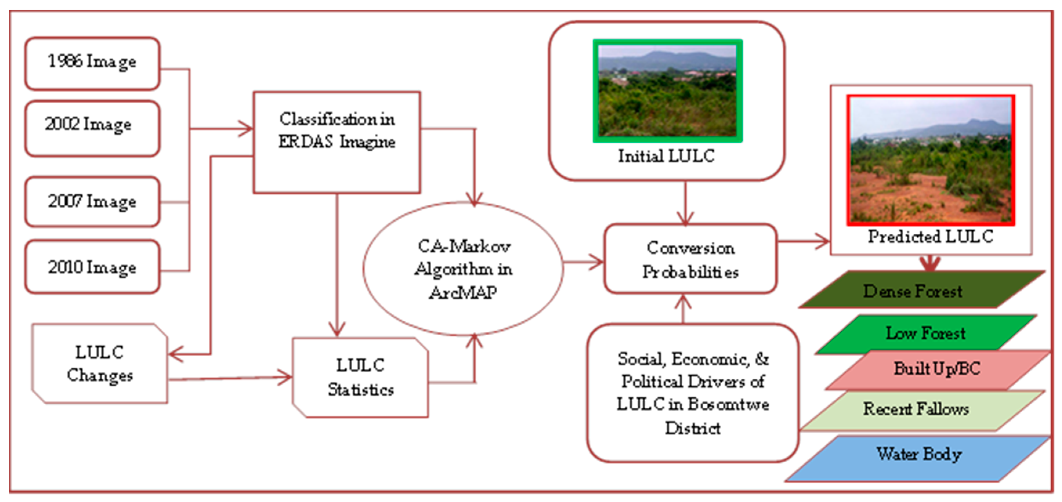
Application of the Markov Chain Analysis
- t+1LUi,j = the potential of cell i,j to change at time t + 1,
- tLUi,j = current land use type of cell i,j at time t,
- tSi,j = states of cell i,j at time t,
- tPx,y,i,j = probability of cell i,j to change from state x to state y at time t + 1.
4. Results and Discussions
4.1. Analysis and Discourse for 1986 LULC Map
4.2. Analysis and Discourse for 2002 LULC Map
4.3. Analysis and Discourse for 2007 LULC Map
4.4. Analysis and Discourse for 2010 LULC Map
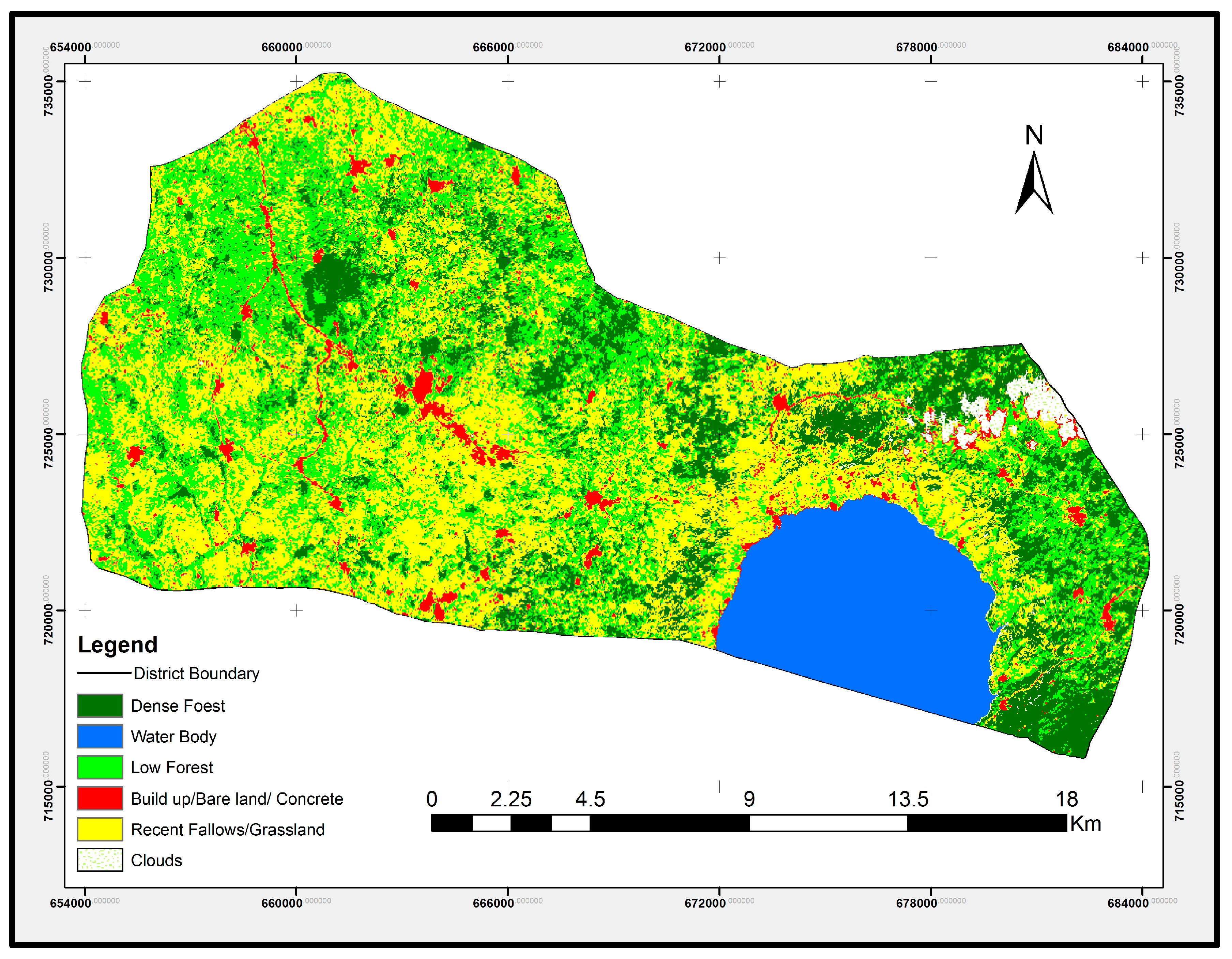
4.5. Analysis and Discourse for 2014 LULC Map
4.6. Land and Land Cover Transition Matrix from 1986 to 2002
4.7. Land Use and Land Cover Transition Matrix from 2002 to 2007
4.8. Results of Land Use Class Transition Matrix from 2007 to 2010
4.9. Land Use Class Transition Matrix from 2010 to 2014
4.10. Predicting the Land Use for the Future
Projections of LULC by 2018 and 2028
5. Conclusions
Acknowledgments
Author Contributions
Conflicts of Interest
Abbreviations
| LULC | Land use land cover |
| DF | Dense Forest |
| LF | Low Forest |
| BBC | Buildup/Bare land and Concrete |
| WB | Water Body |
| RFGL | Recent Fallows and Grasslands |
| TM | Thematic Maps |
| ETM+ | Enhanced Thematic Mapper |
| NPAs | Natural Protected Areas |
| GPS | Garmin Global Positioning System |
| GCPs | Ground Control Points |
| GIS | Geographic Information System |
| ERDAS | Earth Resource Data Analysis System |
| UNEP | United Nations Environment Program |
| USGS | United States Geological Survey |
References
- Hamin, E.M.; Gurran, N. Urban form and climate change: Balancing adaptation and mitigation in the USA and Australia. Habitat Int. 2009, 33, 238–245. [Google Scholar] [CrossRef]
- UNDESA/PD. World Population Prospects: The 2012 Revision, Highlights and Advance Tables. Available online: https://esa.un.org/unpd/wpp/publications/Files/WPP2012_HIGHLIGHTS.pdf (accessed on 20 September 2017).
- UNDESA/PD. World Urbanization Prospects: The 2014 Revision, Highlights; The 2014 Revision, Highlights (ST/ESA/SER.A/352); United Nations: New York, NY, USA, 2014. [Google Scholar]
- Cobbinah, P.B.; Erdiaw-Kwasie, M.O.; Amoateng, P. Rethinking sustainable development within the framework of poverty and urbanization in developing countries. Environ. Dev. 2015, 13, 18–32. [Google Scholar] [CrossRef]
- UN-Habitat. Prosperity of Cities. In State of the World Cities 2012/2013, 1st ed.; 2012; p. 152. Available online: https://sustainabledevelopment.un.org/content/documents/745habitat.pdf (accessed on 20 September 2017).
- Marcotullio, P.J.; Braimoh, A.K.; Onishi, T. The impact of urbanization on soils. In Land Use and Soil Resources; Braimoh, A.K., Vlek, P.L.G., Eds.; Springer: Dordrecht, The Netherlands, 2008; pp. 201–250. [Google Scholar]
- Darkwah, R.M.; Cobbinah, P.B. Stewardship of urban greenery in an era of global urbanization. Int. J. Environ. Chem. Ecol. Geol. Geophys. Eng. 2014, 8, 32–35. [Google Scholar]
- Cobbinah, P.B.; Erdiaw-Kwasie, M.O.; Amoateng, P. Africa’s urbanization: Implications for sustainable development. Cities 2015, 47, 62–72. [Google Scholar] [CrossRef]
- Ravetz, J.; Christian, F.; Nielsen, T.S. The dynamics of peri-urbanization. In Peri-Urban Futures Scenarios and Models for Land Use Change in Europe; Nilsson, K., Pauleit, S., Bell, S., Aalbers, C., Nielsen, T.S., Eds.; Springer: Heidelberg, Germany; New York, NY, USA; Dordrecht, The Netherlands; London, UK, 2013; pp. 13–44. [Google Scholar]
- Mbiba, B.; Huchzermeyer, M. Contentious development: Peri-urban studies in sub-Saharan Africa. Prog. Dev. Stud. 2002, 2, 113–131. [Google Scholar] [CrossRef]
- Simon, D.; McGregor, D.; Nsiah-Gyabaah, K. The changing urban-rural interface of African cities: Definitional issues and an application to Kumasi, Ghana. Environ. Urban. 2004, 16, 235–248. [Google Scholar] [CrossRef]
- Kombe, W.J. Land use dynamics in peri-urban areas and their implications on the urban growth and form: The case of Dar es Salaam, Tanzania. Habitat Int. 2005, 29, 113–135. [Google Scholar] [CrossRef]
- Maina, T.A.D. Community and Social Responses to Land Use Transformations in the Nairobi Rural-Urban Fringe, Kenya. Field Actions Science Reports [Online]-Urban Agriculture. 2010. Available online: http://factsreports.revues.org/435 (accessed on 25 July 2016).
- Tajbakhsh, M.; Memarian, H.; Shahrokhi, H. Analyzing and modeling urban sprawl and land use changes in a developing city using a CA-Markovian approach. Glob. J. Environ. Sci. Manag. 2016, 2, 397–410. [Google Scholar]
- Mandere, M.N.; Ness, B.; Anderberg, S. Peri-urban development, livelihood change and household income: A case study of peri-urban Nyahururu, Kenya. J. Agric. Ext. Rural Dev. 2010, 2, 73–83. [Google Scholar]
- Acheampong, R.A.; Anokye, P.A. Understanding households’ residential location choice in Kumasi’s peri-urban settlements and the implications for sustainable urban growth. Res. Humanit. Soc. Sci. 2013, 3, 60–70. [Google Scholar]
- Laquinta, D.L.; Drescher, A.W. Defining the peri-urban: Rural-urban linkages and institutional connections. Land Reform 2000, 6, 8–26. [Google Scholar]
- Akrofi, E.O.; Whittal, J. Land for peri-urban infrastructure in customary areas: A case study of Kumasi, Ghana. In Proceedings of the FIG Working Week 2011 Bridging the Gap between Cultures, Marrakech, Morocco, 18–22 May 2011. [Google Scholar]
- Amoateng, P.; Cobbinah, P.B.; Owusu-Adade, K. Managing physical development in peri-urban areas of kumasi, Ghana: A case of Abuakwa. J. Urban Environ. Eng. 2013, 7, 96–109. [Google Scholar] [CrossRef]
- McGregor, D.F.M.; Adam-Bradford, A.; Thompson, D.A.; Simon, D. Resource management and agriculture in the peri-urban interface of Kumasi, Ghana: Problems and prospects. Singap. J. Trop. Geogr. 2011, 32, 382–398. [Google Scholar] [CrossRef]
- Ghana Statistical Services. The 2010 Population and Housing Census, Summary of Final Results; Ghana Statistical Services: Accra, Ghana, 2012.
- Ghana Statistical Services. The 2010 Population & Housing Census: National Analytical Report; Ghana Statistical Services: Accra, Ghana, 2013.
- Ghana Statistical Services. The 2000 Population and Housing Census: Special Report on 20 Largest Localities; Ghana Statistical Services: Accra, Ghana, 2002; p. 115.
- Owusu, G. Indigenes and migrants’ access to land in peri-urban areas of Accra, Ghana. Int. Dev. Plan. Rev. 2008, 30, 177–198. [Google Scholar] [CrossRef]
- Cobbinah, P.B.; Amoako, C. Urban sprawl and the loss of peri-urban land in Kumasi, Ghana. Int. J. Soc. Behav. Educ. Econ. Bus. Ind. Eng. 2014, 8, 313–322. [Google Scholar]
- Appiah, D.O.; Bugri, J.T.; Forkuor, E.K.; Boateng, P.K. Determinants of peri-urbanization and land use change patterns in peri-urban Ghana. J. Sustain. Dev. 2014, 7, 95. [Google Scholar] [CrossRef]
- Appiah, D.O.; Schröder, D.; Forkuo, E.; Bugri, J. Application of geo-information techniques in land use and land cover change analysis in a peri-urban district of Ghana. Int. J. Geo-Inf. 2015, 4, 1265–1289. [Google Scholar] [CrossRef]
- Appiah, D.O.; Forkuo, E.K.; Bugri, J.T. Land Use Conversion Probabilities in a Peri-Urban District of Ghana. Chin. J. Urban Environ. Stud. 2015, 3. [Google Scholar] [CrossRef]
- Ochoa-Gaona, S.; Gonza´lez-Espinosa, M. Land use and deforestation in the highlands of Chiapas, Mexico. Appl. Geogr. 2004, 20, 17–42. [Google Scholar] [CrossRef]
- Mirkatouli, J.; Hosseini, A.; Neshat, A. Analysis of land use and land cover spatial pattern based on Markov chains modelling. City Territ. Archit. 2015, 2, 4. [Google Scholar] [CrossRef]
- Lillesand, T.M.; Kiefer, R.W.; Chipman, J.W. Remote Sensing and Image Interpretation, 5th ed.; Wiley: New York, NY, USA, 2003; Volume 4, p. 763. ISBN 0471451525. [Google Scholar]
- Kepner, W.G.; Watts, C.J.; Edmonds, C.M.; Maingi, J.K.; Marsh, S.E.; Luna, G. A landscape approach for detecting and evaluating change in a semi-arid environment. Environ. Monit. Assess. 2000, 64, 179–195. [Google Scholar] [CrossRef]
- Maingi, J.K.; Marsh, S.E.; Kepner, W.G.; Edmonds, C.M. An Accuracy Assessment of 1992 Landsat-Mss Derived Land Cover for the Upper San Pedro Watershed (USA/Mexico); EPA/600/R-02/040 (NTIS PB2002-107521); U.S. Environmental Protection Agency: Washington, DC, USA, 2002.
- Foody, G.M. Status of land cover classification accuracy assessment. Remote Sens. Environ. 2002, 80, 185–201. [Google Scholar] [CrossRef]
- Landis, J.R.; Koch, G.G. The measurement of observer agreement for categorical data. Biometrics 1977, 33, 159–174. [Google Scholar] [CrossRef] [PubMed]
- Brown, D.G.; Pijanowski, B.C.; Duh, J.D. Modeling the relationships between land use and land cover on private lands in the Upper Midwest, USA. J. Environ. Manag. 2000, 59, 247–263. [Google Scholar] [CrossRef]
- Li, X.; Yeh, A.G.-O. Neural-network-based cellular automata for simulating multiple land use changes using GIS. Int. J. Geogr. Inf. Sci. 2002, 16, 323–343. [Google Scholar] [CrossRef]
- Fang, S.; Gertner, G.; Sun, Z.; Anderson, A. The impact of interactions in spatial simulation of the dynamics of urban sprawl. Landsc. Urban Plan. 2005, 73, 294–306. [Google Scholar] [CrossRef]
- Yeh, A.; Li, X. Errors and uncertainties in urban cellular automata. Comput. Environ. Urban Syst. 2006, 30, 10–28. [Google Scholar] [CrossRef]
- Samat, N.; Hasni, R.; Elhadary, Y.A.E. Modelling Land Use Changes at the Peri-Urban Areas Using Geographic Information Systems and Cellular Automata Model. J. Sustain. Dev. 2011, 4, 72–84. [Google Scholar] [CrossRef]
- Ofori-Sarpong, E. The 1981–1983 droughts in Ghana. Singap. J. Trop. Geogr. 1986, 7, 108–127. [Google Scholar] [CrossRef]
- García-Frapolli, E.; Ayala-Orozco, B.; Bonilla-Moheno, M.; Espadas-Manrique, C.; Ramos-Fernández, G. Biodiversity conservation, traditional agriculture and ecotourism: Land cover/land use change projections for a natural protected area in the Northeastern Yucatan peninsula, Mexico. Landsc. Urban Plan. 2007, 83, 137–153. [Google Scholar] [CrossRef]
- Osei-Wusu Adjei, P.; Buor, D.; Addrah, P. Geo-Spatial Analysis of Land Use and Land Cover Changes in the Lake Bosomtwe Basin of Ghana. Available online: https://www.ajol.info/index.php/gjg/article/viewFile/111131/100899 (accessed on 20 September 2017).
- United Nations Environment Programme. Sudan Post-Conflict Environmental Assessment. Available online: https://postconflict.unep.ch/publications/UNEP_Sudan.pdf (accessed on 20 September 2017).
- Akuoko, D.A. The Preservation of Forest and Land in Connection to Our Forefathers. 2001. Available online: http://www.takingitglobal.org/express/article.html (accessed on 29 August 2016).
- Palermo, P. Whatever is happening to urban planning and urban design? Musings on the current gap between theory and practice. City Territ. Archit. 2014, 1, 7. [Google Scholar] [CrossRef]
- Hens, L.; Boon, E. Institutional, legal, and economic instruments in Ghana’s environmental policy. Environ. Manag. 1999, 24, 337–351. [Google Scholar] [CrossRef]
- Fearnside, P.M. Saving tropical forests as a global warming countermeasure: An issue that divides the environmental movement. Ecol. Econ. 2001, 39, 167–184. [Google Scholar] [CrossRef]
- Klooster, D.; Masera, O. Community forest management in Mexico: Carbon mitigation and biodiversity conservation through rural development. Glob. Environ. Chang. 2000, 10, 259–272. [Google Scholar] [CrossRef]
- Lambin, E.F.; Turner, B.L.; Geist, H.J.; Agbola, S.B.; Angelsen, A.; Bruce, J.W.; Coomes, O.T.; Dirzo, R.; Fischer, G.; Folke, C.; et al. The causes of land-use and land-cover change: Moving beyond the myths. Glob. Environ. Chang. 2001, 11, 261–269. [Google Scholar] [CrossRef]
- Masek, J.G.; Lindsay, F.E.; Goward, S.N. Dynamics of urban growth in the Washington dc metropolitan area, 1973–1996, from Landsat observations. Int. J. Remote Sens. 2000, 21, 3473–3486. [Google Scholar] [CrossRef]
- He, C.; Okada, N.; Zhang, Q.; Shi, P.; Li, J. Modelling dynamic urban expansion processes incorporating a potential model with cellular automata. Landsc. Urban Plan. 2008, 86, 79–91. [Google Scholar] [CrossRef]
- Mas, J.-F. Monitoring land-cover changes: A comparison of change detection techniques. Int. J. Remote Sens. 1999, 20, 139–152. [Google Scholar] [CrossRef]
- Repetto, R. Accounting for environmental assets. Sci. Am. 1992, 266, 94–100. [Google Scholar] [CrossRef] [PubMed]
- Vitousek, P.M.; Mooney, H.A.; Lubchenco, J.; Melillo, J.M. Human domination of earth’s ecosystems. Science 1997, 277, 494–499. [Google Scholar] [CrossRef]
- Foley, J.A.; DeFries, R.; Asner, G.P.; Barford, C.; Bonan, G.; Carpenter, S.R.; Chapin, F.S.; Coe, M.T.; Daily, G.C.; Gibbs, H.K.; et al. Global consequences of land use. Science 2005, 309, 570–574. [Google Scholar] [CrossRef] [PubMed]
- Turner, B.L., II; Lambin, E.F.; Reenberg, A. The emergence of land change science for global environmental change and sustainability. Proc. Natl. Acad. Sci. USA 2007, 104, 20666–20671. [Google Scholar] [CrossRef] [PubMed]
- Jensen, J.R. Digital change detection. In Introductory Digital Image Processing: A Remote Sensing Perspective, 3rd ed.; Prentice Hall: Upper Saddle River, NJ, USA, 2004; pp. 467–494. [Google Scholar]
- Daily, G.C.; Alexander, S.; Ehrlich, P.R.; Goulder, L.; Lubchenco, J.; Matson, P.A.; Mooney, H.A.; Postel, S.; Schneider, S.H.; Tilman, D.; et al. Ecosystem Services: Benefits Supplied to Human Societies by Natural Ecosystems. Available online: http://www.esa.org/esa/wp-content/uploads/2013/2003/issue2012.pdf (accessed on 20 September 2017).
- Costanza, R.; D’Arge, R.; De Groot, R.; Farber, S.; Grasso, M.; Hannon, B.; Limburg, K.; Naeem, S.; O’Neill, R.V.; Paruelo, J. The value of the world’s ecosystem services and natural capital. Nature 1997, 387, 253–260. [Google Scholar] [CrossRef]
- Elvidge, C.D.; Sutton, P.C.; Wagner, T.K.; Ryzner, R.; Vogelmann, J.E.; Goerz, S.J.; Smith, A.J.; Jantz, C.; Seto, K.C.; Wang, M.L.I.Y.Q.; et al. Urbanization. In Land Change Science Observing, Monitoring and Understanding Trajectories of Change on the Earth’s Surface; Gutman, G., Janetos, A.C., Justice, C.O., Moran, E.F., Mustard, J.F., Rindfuss, R.R., Skole, D., Turner, B.L., II, Cochrane, M.A., Eds.; Kluwer Academic Publishers: Dordrecht, The Netherlands; Boston, MA, USA; London, UK, 2004; Volume 6, pp. 315–329. [Google Scholar]
- Velázquez, A.; Durán, E.; Ramı́rez, I.; Mas, J.-F.; Bocco, G.; Ramı́rez, G.; Palacio, J.-L. Land use-cover change processes in highly biodiverse areas: The case of Oaxaca, Mexico. Glob. Environ. Chang. 2003, 13, 175–184. [Google Scholar] [CrossRef]
- Evely, A. Dead Planet, Living Planet. Biodiversity and Ecosystem Restoration for Sustainable Development, a Rapid Response Assessment; Nellemann, C., Corcoran, E., Eds.; Birkland Trykkeri: Birkeland, Norway, 2010; p. 78. [Google Scholar]
- Yalew, S.G.; Mul, M.L.; van Griensven, A.; Teferi, E.; Priess, J.; Schweitzer, C.; van Der Zaag, P. Land-Use Change Modelling in the Upper Blue Nile Basin. Environments 2016, 3, 21. [Google Scholar] [CrossRef]
- Reis, S. Analyzing Land Use/Land Cover Changes Using Remote Sensing and GIS in Rize, North-East Turkey. Sensors 2008, 8, 6188–6202. [Google Scholar] [CrossRef] [PubMed]
- Al-Bakri, J.T.; Duqqah, M.; Brewer, T. Application of Remote Sensing and GIS for Modeling and Assessment of Land Use/Cover Change in Amman/Jordan. J. Geogr. Inf. Syst. 2013, 5, 509–519. [Google Scholar] [CrossRef]
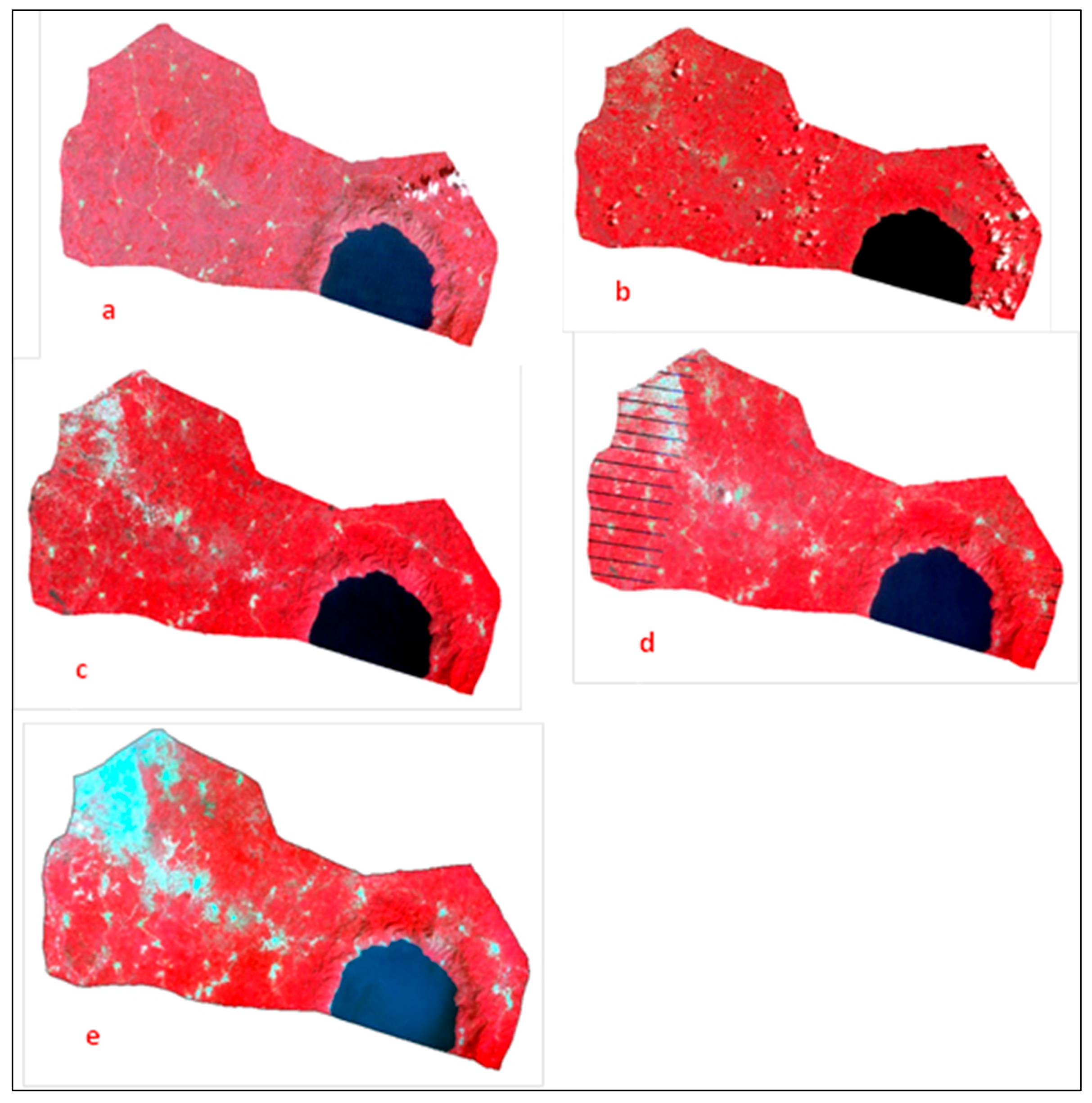
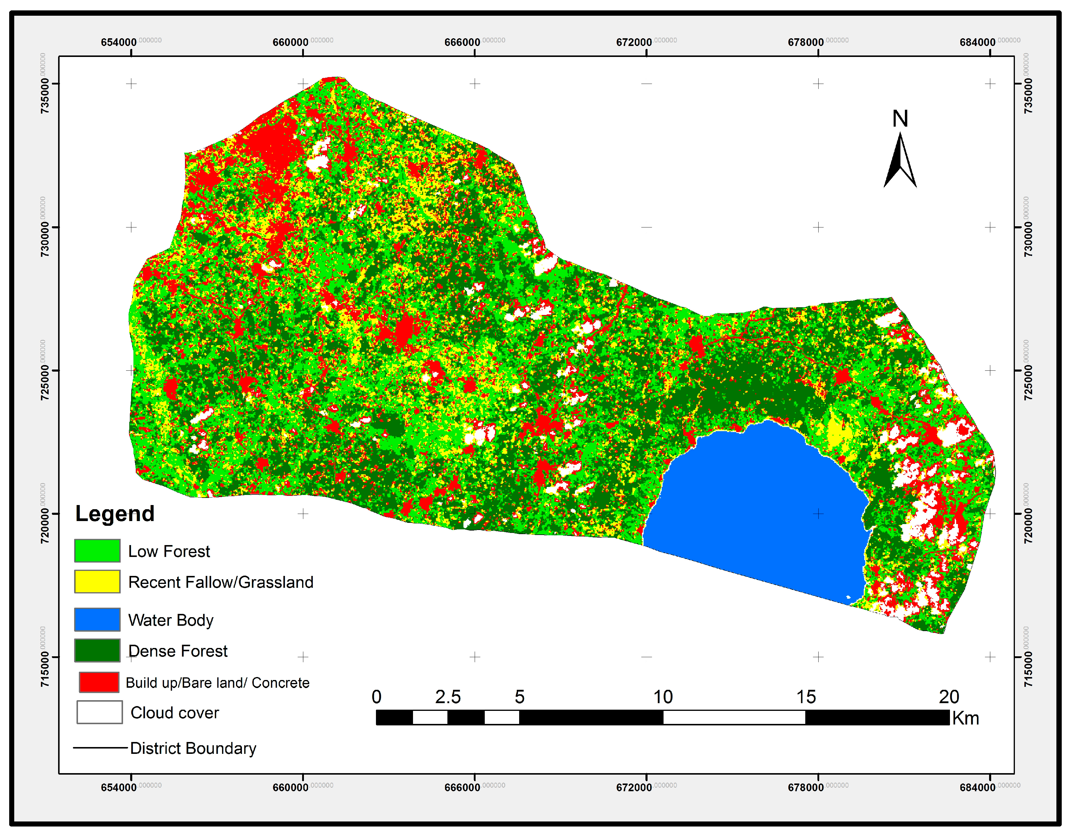

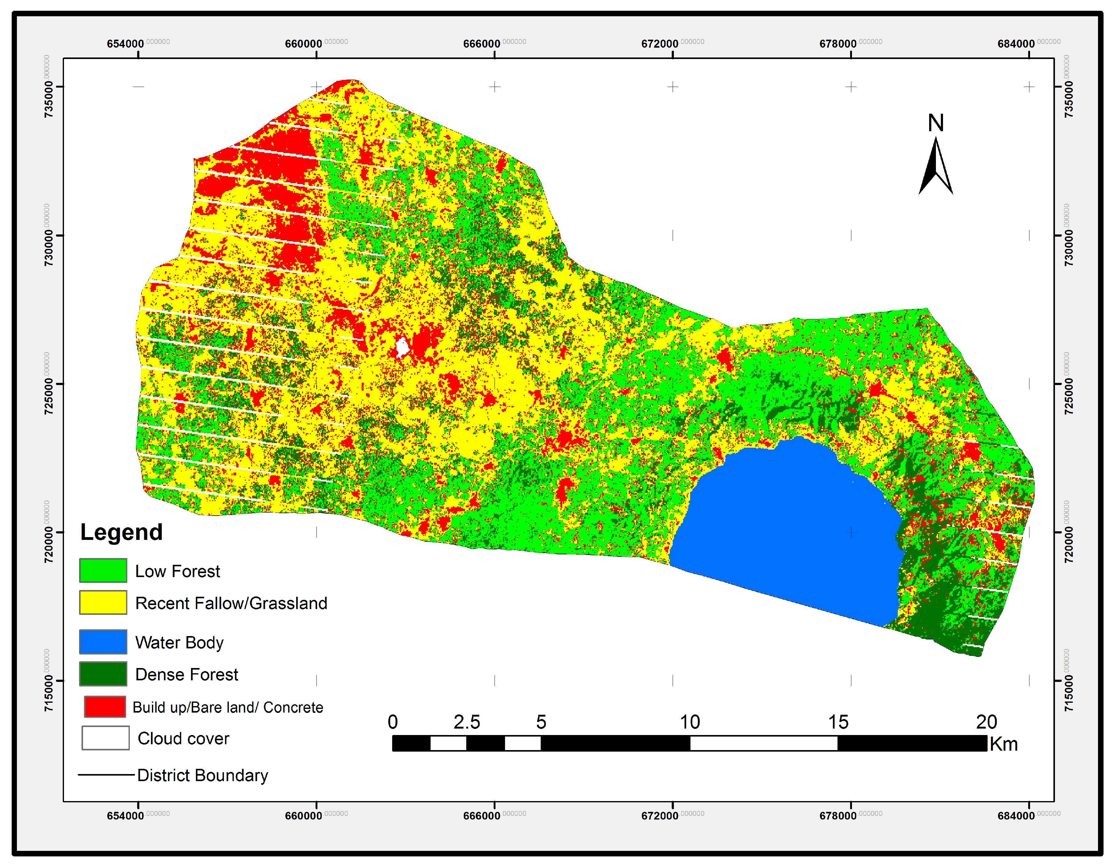
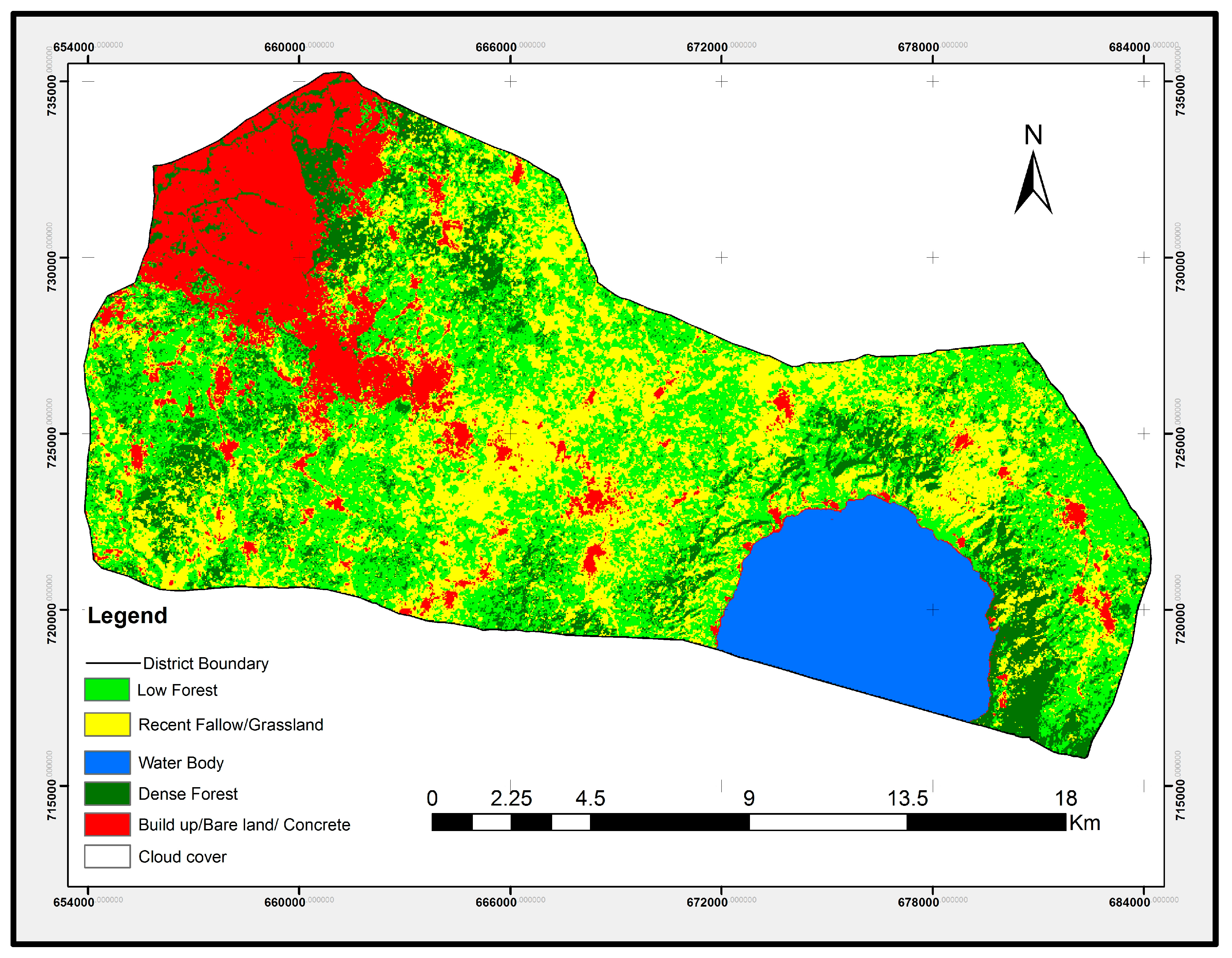
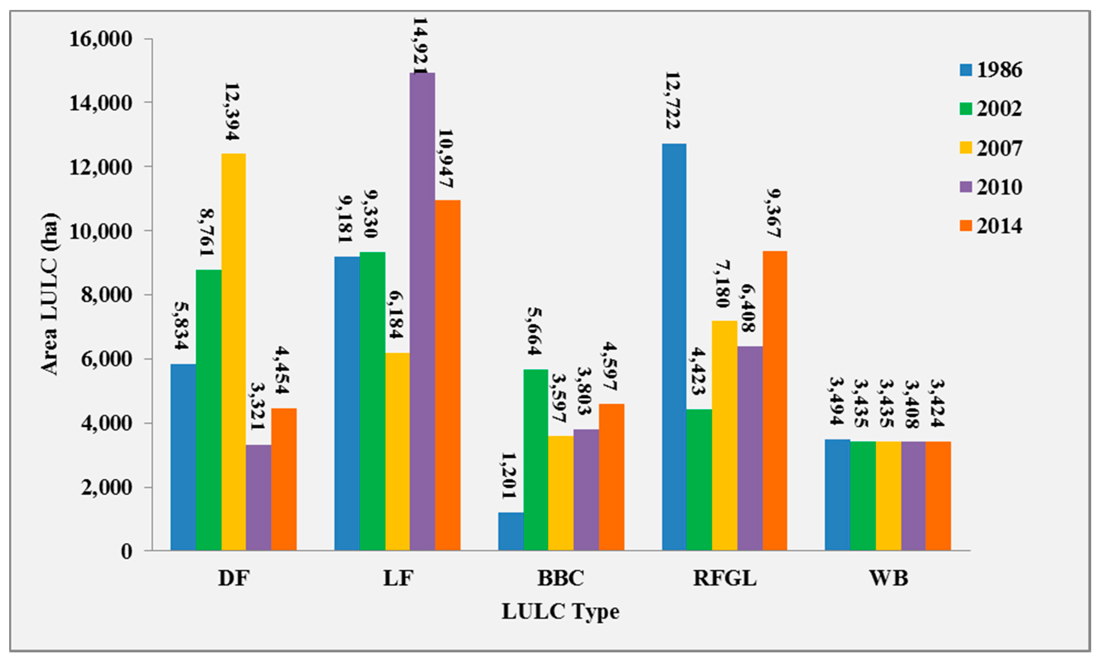

| Year | Satellite Sensor | Date Acquired | Spatial Resolution | Bands Used |
|---|---|---|---|---|
| 1986 | Landsat 5 TM | 1st of November | 30 m × 30 m | 1, 2, 3, 4, 5 & 7 |
| 2002 | Landsat 7 ETM | 7th of May | 30 m × 30 m | 1, 2, 3, 4, 5 & 7 |
| 2007 | Landsat 7 ETM+ | 3rd of February | 30 m × 30 m | 1, 2, 3, 4, 5 & 7 |
| 2010 | Landsat 7 ETM+ | 6th of February | 30 m × 30 m | 1, 2, 3, 4, 5 & 7 |
| Year | 1986 | 2002 | 2007 | 2010 | 2014 | |||||
|---|---|---|---|---|---|---|---|---|---|---|
| LULC | Area (ha) | % | Area (ha) | % | Area (ha) | % | Area (ha) | % | Area (ha) | % |
| DF | 5834.1 | 18.0 | 8760.9 | 27.7 | 12,394.0 | 37.8 | 3320.6 | 10.4 | 4454.46 | 13.6 |
| LF | 9180.6 | 28.3 | 9329.8 | 29.5 | 6183.6 | 18.9 | 14,920.9 | 46.8 | 10,947.33 | 33.4 |
| BBC | 1201.0 | 3.7 | 5664.2 | 17.9 | 3597.3 | 11.0 | 3803.1 | 11.9 | 4596.93 | 14.0 |
| RFGL | 12,722 | 39.2 | 4422.9 | 14.0 | 7179.8 | 21.9 | 6408.4 | 20.1 | 9366.75 | 28.5 |
| WB | 3494.2 | 10.8 | 3434.9 | 10.9 | 3435.0 | 10.5 | 3408.2 | 10.7 | 3424.32 | 10.5 |
| Total | 32,432 | 100.0 | 31,612.59 | 100.0 | 32,789.79 | 100.0 | 31,861.30 | 100.0 | 32,789.79 | 100.0 |
| LULC Classes | 2002 Image | ||||||
|---|---|---|---|---|---|---|---|
| DF | LF | BB/Conc. | RF/GL | WB | 1986 Total | ||
| 1986 Image | Dense Forest | 2054 | 1409 | 777 | 646 | 0 | 4886 |
| Low Forest | 2217 | 2767 | 1675 | 1264 | 0 | 7922 | |
| Build Bare/Conc. | 132 | 237 | 550 | 127 | 4 | 1050 | |
| Recent fallows and grasslands | 3386 | 3900 | 2043 | 1890 | 1 | 11,219 | |
| Water Body | 3 | 7 | 3 | 15 | 3092 | 3120 | |
| 2002 Total | 7791 | 8318 | 5048 | 3942 | 3098 | 28,197 | |
| Change (Ha) | +2905 | +396 | +3998 | −7277 | −22 | 14,662 | |
| Change (%) | +59 | +5 | +380 | −65 | −0.7 | 52 | |
| LULC Classes | 2002 Image | ||||||
|---|---|---|---|---|---|---|---|
| DF | LF | BB/Conc. | RF/GL | WB | Total | ||
| 1986 Image | Dense Forest | 0.42 | 0.29 | 0.16 | 0.13 | 0.00 | 1.00 |
| Low Forest | 0.28 | 0.35 | 0.21 | 0.16 | 0.00 | 1.00 | |
| Build up/Bare/Concrete | 0.13 | 0.23 | 0.52 | 0.12 | 0.00 | 1.00 | |
| Recent fallows/grasslands | 0.30 | 0.35 | 0.18 | 0.17 | 0.00 | 1.00 | |
| Water Body | 0.00 | 0.00 | 0.00 | 0.00 | 0.99 | 1.00 | |
| LULC Classes | 2007 Image | ||||||
|---|---|---|---|---|---|---|---|
| DF | LF | BB/Conc. | RF/GL | WB | 2002 Total | ||
| 2002 Image | Dense Forest | 4806 | 1822 | 663 | 1470 | 0 | 8761 |
| Low Forest | 2358 | 1796 | 1514 | 3661 | 0 | 9330 | |
| Build Bare/Conc. | 1338 | 702 | 2314 | 1311 | 0 | 5664 | |
| Recent fallows/grassland | 1211 | 608 | 820 | 1784 | 0 | 4423 | |
| Water Body | 0 | 0 | 4 | 24 | 3407 | 3435 | |
| 2007 Total | 9713 | 4929 | 5315 | 8250 | 3407 | 31,612 | |
| Change (ha) | +952 | −4401 | −349 | +3827 | −28 | 9557 | |
| Change (%) | +11 | −47 | −6 | +87 | −0.8 | 30 | |
| LULC Classes | 2002 Image | ||||||
|---|---|---|---|---|---|---|---|
| DF | LF | BB/Conc. | RF/GL | WB | Total | ||
| 2002 Image | Dense Forest | 0.55 | 0.21 | 0.08 | 0.17 | 0.00 | 1.00 |
| Low Forest | 0.25 | 0.19 | 0.16 | 0.39 | 0.00 | 1.00 | |
| Build up/Bare/Concrete | 0.24 | 0.12 | 0.41 | 0.23 | 0.00 | 1.00 | |
| Recent fallows/grasslands | 0.27 | 0.14 | 0.19 | 0.40 | 0.00 | 1.00 | |
| Water Body | 0.00 | 0.00 | 0.00 | 0.01 | 0.99 | 1.00 | |
| LULC Classes | 2010 Image | ||||||
|---|---|---|---|---|---|---|---|
| DF | LF | BB/Conc. | RF/GL | WB | 2007 Total | ||
| 2007 Image | Dense Forest | 2639 | 4040 | 1364 | 2100 | 0 | 10,143 |
| Low Forest | 378 | 2866 | 629 | 1225 | 0 | 5099 | |
| Build Bare/Conc. | 146 | 532 | 2333 | 2253 | 0 | 5264 | |
| Recent fallows/grasslands | 416 | 699 | 1128 | 5952 | 14 | 8209 | |
| Water Body | 2 | 0 | 0 | 1 | 3406 | 3409 | |
| 2010 Total | 3581 | 8138 | 5454 | 11,530 | 3420 | 32,123 | |
| Change (Ha) | −6562 | +3039 | +190 | +3321 | +11 | 13,123 | |
| Change (%) | −65 | +60 | +4 | +40 | +0.3 | 41 | |
| LULC Classes | 2010 Image | ||||||
|---|---|---|---|---|---|---|---|
| DF | LF | BB/Conc. | RF/GL | WB | Total | ||
| 2007 Image | Dense Forest | 0.26 | 0.40 | 0.13 | 0.21 | 0.00 | 1.00 |
| Low Forest | 0.07 | 0.56 | 0.12 | 0.24 | 0.00 | 1.00 | |
| Build up/Bare/Concrete | 0.03 | 0.10 | 0.44 | 0.43 | 0.00 | 1.00 | |
| Recent fallow/grasslands | 0.05 | 0.09 | 0.14 | 0.73 | 0.00 | 1.00 | |
| Water Body | 0.00 | 0.00 | 0.00 | 0.00 | 1.00 | 1.00 | |
| LULC Classes | 2014 Image | ||||||
|---|---|---|---|---|---|---|---|
| DF | LF | BB/Conc. | RF/GL | WB | 2010 Total | ||
| 2010 Image | Dense Forest | 1386.5 | 1,400.9 | 40.5 | 479.6 | 13.1 | 3320.6 |
| Low Forest | 2313.7 | 7621.1 | 659.9 | 4326.2 | 0.0 | 14,920.9 | |
| Build up/Bare/Concrete | 163.3 | 508.8 | 2298.4 | 832.7 | 0.0 | 3803.1 | |
| Recent fallow/Grassland | 427.1 | 1148.0 | 1273.5 | 3558.9 | 0.9 | 6408.4 | |
| Water Body | 0.0 | 0.0 | 1.6 | 0.0 | 3406.6 | 3408.2 | |
| 2014 Total | 4290.5 | 10,678.9 | 4273.9 | 9197.4 | 3420.6 | 31,861.3 | |
| Change (Ha) | +969.9 | −4242 | +470.8 | +2,789 | +12.4 | 8,484.1 | |
| Change (%) | 29.2 | −28.4 | 12.4 | 43.5 | 0.4 | 26.6 | |
| LULC Classes | 2014 Image | ||||||
|---|---|---|---|---|---|---|---|
| DF | LF | BB/Conc. | RF/GL | WB | Total | ||
| 2010 Image | Dense Forest | 0.42 | 0.42 | 0.01 | 0.14 | 0.00 | 1.00 |
| Low Forest | 0.16 | 0.51 | 0.04 | 0.29 | 0.00 | 1.00 | |
| Build up/Bare/Concrete | 0.04 | 0.13 | 0.60 | 0.22 | 0.00 | 1.00 | |
| Open Woodland/Farm Lands | 0.07 | 0.18 | 0.20 | 0.56 | 0.00 | 1.00 | |
| Water Body | 0.00 | 0.00 | 0.00 | 0.00 | 1.00 | 1.00 | |
© 2017 by the authors. Licensee MDPI, Basel, Switzerland. This article is an open access article distributed under the terms and conditions of the Creative Commons Attribution (CC BY) license (http://creativecommons.org/licenses/by/4.0/).
Share and Cite
Appiah, D.O.; Forkuo, E.K.; Bugri, J.T.; Apreku, T.O. Geospatial Analysis of Land Use and Land Cover Transitions from 1986–2014 in a Peri-Urban Ghana. Geosciences 2017, 7, 125. https://doi.org/10.3390/geosciences7040125
Appiah DO, Forkuo EK, Bugri JT, Apreku TO. Geospatial Analysis of Land Use and Land Cover Transitions from 1986–2014 in a Peri-Urban Ghana. Geosciences. 2017; 7(4):125. https://doi.org/10.3390/geosciences7040125
Chicago/Turabian StyleAppiah, Divine Odame, Eric Kwabena Forkuo, John Tiah Bugri, and Theresa Oteng Apreku. 2017. "Geospatial Analysis of Land Use and Land Cover Transitions from 1986–2014 in a Peri-Urban Ghana" Geosciences 7, no. 4: 125. https://doi.org/10.3390/geosciences7040125
APA StyleAppiah, D. O., Forkuo, E. K., Bugri, J. T., & Apreku, T. O. (2017). Geospatial Analysis of Land Use and Land Cover Transitions from 1986–2014 in a Peri-Urban Ghana. Geosciences, 7(4), 125. https://doi.org/10.3390/geosciences7040125


