Abstract
The basement of the Rattlesnake Creek terrane (RCT) in the Klamath Mountains is a mélange of metamorphosed sedimentary and igneous blocks. Recent work shows that the overlying RCT cover sequence has a North American provenance but formed after accretion to the continental margin, so it is unclear if the basement mélange formed exotic or endemic to North America. This study presents petrography and zircon geochronology from RCT metasedimentary blocks and crosscutting intrusions. The southernmost RCT preserves both Early Jurassic and Middle-Late Jurassic cover sequence deposits and records continental clasts and 33% pre-Mesozoic zircons at ~201 Ma, effectively none at ~191 Ma, and 79–90% from 168 to 163 Ma. During active magmatism 207–193 Ma, the RCT was receiving continental sediment, inconsistent with a distant intraoceanic arc. We interpret that the RCT subduction zone formed proximal to North America in the Late Triassic and that there was a sediment pathway to the RCT at ~201 Ma. During Middle to Late Jurassic rifting and subsequent Nevadan compression, the cover sequences were dismembered and incorporated into the mélange by tectonic and sedimentary processes. The age and provenance of metasedimentary deposits in the RCT is inconsistent with west-dipping subduction models in the Klamath Mountains region.
1. Introduction
The Klamath Mountains province (Figure 1) straddles the California–Oregon border and is composed of a series of thrust-bounded tectonostratigraphic terranes. It is also the largest exposure of pre-Cenozoic rocks on the western continental margin of North America [1], making it a key location to study Mesozoic terrane tectonics. W. P. Irwin introduced the term “terrane” in the Klamath Mountains, as a fault-bounded tract of rocks with similar geologic features, such as stratigraphic formations, intrusive rocks, mineral deposits, and tectonic history, which differ from adjacent tracts [1,2]. Terranes are now recognized around the world and are critical to reconstructing plate tectonic histories. Yet the ages, correlations, and tectonic settings of many of these original tectonostratigraphic terranes in the Klamath Mountains are still debated.
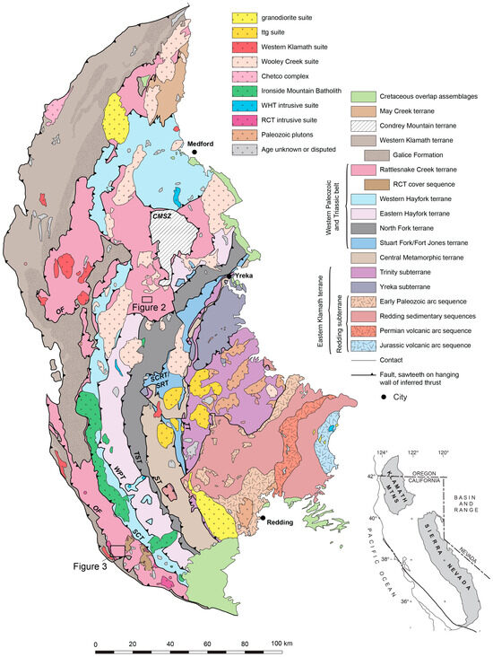
Figure 1.
Geologic map of the Klamath Mountains showing tectonostratigraphic terranes, plutons, and major faults. Modified after Irwin et al. [3] and Snoke and Barnes [1]. RCT cover sequence after Wright and Wyld [4]. Locations of Figure 2 in the Marble Mountains region and Figure 3 in the Rattlesnake Creek area are marked. CMSZ—Condrey Mountain shear zone; OF—Orleans fault; RCT—Rattlesnake Creek terrane; SCRT/SRT—Soap Creek Ridge thrust/Salmon River thrust; SCT—Salt Creek thrust; ST—Siskiyou thrust; TST—Twin Sisters thrust; TT—Trinity thrust; ttg—tonalite-trondhjemite-granodiorite; WHT—Western Hayfork terrane; WPT—Wilson Point thrust.
One of the most enigmatic terranes is the Rattlesnake Creek terrane (RCT), which has been interpreted as forming marginal to North America in the Late Triassic to Early Jurassic before Middle Jurassic accretion to the continental margin [4,5,6,7] or as an east-facing exotic archipelago which formed far from North America and accreted by the Middle Jurassic [8,9] or in the Late Jurassic [10,11]. The RCT basement is a tectonic mélange with blocks of mostly ocean plate stratigraphy [4,5,12], but the cover sequence contains arc-related lavas and terrigenous detritus linked to North America [4,7,13]. Previous work constrained the deposition of the RCT cover sequence to Late Triassic to Early Jurassic based on a ~198 Ma crosscutting intrusion and fossils from coherent and dismembered deposits interpreted as the cover sequence [4]. However, recent detrital zircon analyses of clastic rocks in the cover sequence have maximum depositional ages (MDAs) 170–161 Ma and abundant Paleozoic-Archean ages [13]. Since at least part of the cover sequence is Middle-Late Jurassic, it is now less clear if the 207–193 Ma RCT intrusive suite [4] formed as an intraoceanic or marginal arc in the Late Triassic to Early Jurassic. Here, we present new petrographic data and 1245 new detrital zircon U-Pb ages from metasedimentary rocks in the mélange and crosscutting intrusions. Our data provide additional evidence of an Early Jurassic cover sequence with continental input, indicating proximity of the RCT to North America at ~201 Ma, and document Middle-Late Jurassic cover sequence farther west than previously mapped in the southern RCT.
2. Geologic Background
Terranes in the Klamath Mountains province (Figure 1) are regionally east-dipping but locally folded and cut by high angle faults and intruded by ultramafic to silicic plutons that range from early Paleozoic to early Cretaceous [1]. Cretaceous rocks of the Hornbrook Formation and Great Valley Group as well as Tertiary volcanic rocks of the Western Cascade Group unconformably overlie the Klamath Mountains [1]. Irwin [2] defined four major lithotectonic belts: the Eastern Klamath terrane, the Central Metamorphic belt, the Western Paleozoic and Triassic belt (WPzTrB), and the Western Klamath terrane (Figure 1). These belts are generally younger from east to west, right side up, and separated by east-dipping, west-verging thrust faults [14]. The WPzTrB is the largest of the four major belts and from east to west includes the Stuart Fork/Fort Jones terrane, the North Fork terrane (NFT), the Eastern Hayfork terrane (EHT), the Western Hayfork terrane (WHT), and the Rattlesnake Creek terrane (RCT). To the east are younger rocks of the Western Jurassic belt: the Josephine ophiolite, the Rogue–Chetco complex, and the Galice Formation.
2.1. The North Fork, Eastern Hayfork, and Western Hayfork Terranes
The NFT is an assemblage of internally folded ophiolitic rocks overlain by oceanic volcanic sedimentary rocks (Figure 1) [15]. Age control data include Permian to Middle Jurassic fossils in limestone and chert [16], a conservative 310–265 Ma zircon U-Pb age from a plagiogranite [15], a ~200 Ma 40Ar/39Ar hornblende age on a gabbro cutting diabase [17], and 225–180 Ma U-Pb detrital zircon ages from argillites in the central and southern NFT [16,18]. Some argillite detrital zircon ages of the NFT are similar to the early Jurassic Eastern Klamath arc and older Klamath terranes, indicating endemic formation [14,19,20].
The EHT is a mélange and broken formation of weakly crystallized and intensely tectonized metachert with fine-grained argillite as well as tectonic blocks of greenstone, blueschist, and small amounts of marble, quartzite, and siliceous schist [14,21]. Limestone and chert fossils range from Early Pennsylvanian to Late Triassic [16]. Matrix argillites with whole-rock 40Ar/39Ar at 263 Ma [22], continental zircon ages [18,23], and detrital zircon MDAs at ~272 Ma, ~211 Ma, and ~201 Ma suggest growth by progressive subduction accretion [18]. Detrital zircon U-Pb ages in exotic metasandstone blocks are dominantly Paleoproterozoic and Archean, consistent with the North American Cordillera [21], and mica and amphibole 40Ar/39Ar ages in micaceous quartzite blocks are 360–346 Ma [22].
The WHT is a Middle Jurassic arc cover sequence, and K-Ar and 40Ar/39Ar ages of magmatic amphiboles are 177–171 Ma with on K-Ar age at 168 Ma [24,25]. At ~170 Ma, the WHT was intruded by the Ironside Mountain Batholith [24], so the youngest WHT amphibole ages may represent cooling ages rather than true depositional ages. The presence of rare quartz- and K-feldspar-rich arenite is consistent with a minor component of sediment input from the North American craton above an east-dipping subduction zone [26], and the WHT has been interpreted as originally depositional on the EHT and RCT [12,24,25].
2.2. Rattlesnake Creek Terrane
The RCT can be divided into a basement mélange ± serpentinite-matrix and peridotite massifs and a cover sequence of volcanic and sedimentary rocks [4]. Many gabbroic to quartz dioritic plutonic bodies, referred to here as the RCT intrusive suite, intrude both the basement assemblage and rocks interpreted as the cover sequence of the RCT, and the intrusions and cover sequence are locally incorporated into the basement mélange [4].
2.2.1. Basement Mélange
There are significant differences in the structure and metamorphism of the RCT basement mélange in the southern and central Klamath Mountains. The southern RCT is a block-in-matrix mélange with a serpentinite matrix and has been metamorphosed to subgreenschist grade with well-preserved protolith texture with limited recrystallization [4]. Abundant fragments of harzburgite and minor dunite increase in serpentinization into the matrix and are likely its source [4]. Blocks include felsic to ultramafic plutonic bodies, greenstone, amphibolite, pillow basalt, chert, limestone, metavolcanic, and volcaniclastic rocks [4,5].
In the central Klamath Mountains, the RCT (an area of which has been referred to as the Marble Mountain terrane after Blake et al. [27]) is metamorphosed to amphibolite and even granulite facies [12,28,29,30]. Blocks of metasedimentary, metavolcanic, and metamorphosed ultramafic rocks are juxtaposed in a block-on-block mélange with little matrix [5,12]. Metamorphic assemblages in ultramafic, pelitic, and calcareous blocks record a wide range of metamorphic conditions at 500–800 °C and 3.5–9 kbar [5,12,29,30,31,32]. Mixed conditions are consistent with high-grade blocks dismembered into the mélange followed by regional low- to medium-grade metamorphism [12]. Metabasalt blocks in the basement mélange are typically 45–55% SiO2 [4,33,34], and elemental analyses are consistent with MORB and within-plate basalt (WPB) signatures, indicating oceanic floor and seamounts [4], although the Marble Mountains also contain some minor arc-related calc-alkaline and island arc tholeiite (IAT) metabasites [5].
Fossils in the basement mélange have been mostly identified as Triassic to latest Middle Jurassic with a few Carboniferous and Permian fossil sites [16], and ammonites originally interpreted as Devonian [35] are now interpreted as Late Triassic [36]. Based on Nd isotopes in argillaceous blocks, the RCT basement mélange incorporates Precambrian sediment that may have been transported by wind, but the depositional age of the blocks and the timing of their incorporation into the mélange is unknown [7]. Zircon U-Pb analyses from a para-amphibolite block in the RCT near the Wooley Creek batholith yielded few ages 212–154 Ma [23].
2.2.2. Cover Sequence
The cover sequence was defined by Wright and Wyld [4] in the southern RCT (Figure 1) and divided into the Salt Creek assemblage and the Dubakella Mountain assemblage, but other metavolcanic and metasedimentary sequences farther north may be equivalent [7,13,37,38]. The Salt Creek assemblage consists of basalt, chert, argillite, and clastic sedimentary rocks, consistent with deposition in a shallow marine environment [4]. The overlying Dubakella Mountain assemblage is divided into the augite porphyry and quartz porphyry volcanic members [4]. This assemblage was deposited near an active volcanic system and has been crosscut by intrusions, one of which is a quartz diorite with a U-Pb zircon age of 198 Ma and interpreted as part of the RCT intrusive suite [4]. Interlayered chert beds and blocks that Wright and Wyld [4] interpret to be dismembered equivalents of the cover sequence yield Late Triassic to Early Jurassic radiolarians [4,39,40].
Irwin et al. [41] mapped the area of Wright and Wyld’s [4] cover sequence as mafic volcanic-dominated sections of the basement mélange, scattered clastic rocks, limestone blocks, minor amphibolite blocks, and bodies of intermediate to silicic volcanic rocks >2 km across. Many details of the mapping do not agree between Wright and Wyld [4] and Irwin et al. [41], including the extents of lithologies and interpretations of basement mélange or volcanic or sedimentary sequences. However, in the northwest corner of each map, both studies map an area of volcanic rocks which are locally cut by intrusions interpreted by both as equivalent to the RCT intrusive suite [4,41]. This is the same location as the quartz diorite dated to 198 Ma described above [4].
The RCT cover sequence has been linked to North America based on the presence of quartzose and metamorphic clasts [4], isotopic similarity of argillites to major river systems [7], and abundance of pre-Mesozoic detrital zircon ages [13]. LaMaskin et al. [13] recently documented detrital zircon U-Pb MDAs from the cover sequence at ~170, 162, and 161 Ma, much younger than the previously mapped crosscutting relationships and fossil ages suggest [4,41]. Field relationships of the cover sequence need to be reexamined to determine the extent and continuity of the cover sequence compared to volcanic rocks of oceanic origin and if there are multiple phases of cover sequence deposition.
2.2.3. Intrusive Suite
The RCT intrusive suite is composed of gabbroic to quartz dioritic intrusions, ranging from sizes of <1 km2 to sills and plutonic masses of >10 km2 [42,43] which intrude the basement mélange [4,41] and cover sequence [4]. Zircon U-Pb ages of the intrusive suite are 207–193 Ma from quartz diorite, but more mafic plutonic bodies did not yield zircon and are undated [4]. The Saddle Gulch pluton has a hornblende K-Ar age of 189 Ma [40], but no zircon has been dated. Geochemistry of the more mafic components of the RCT intrusive suite is consistent with MORB and IAT [4]. The RCT intrusive suite both cuts the mélange and is incorporated into it, indicating multiple episodes of mélange incorporation [4].
2.2.4. Previous Tectonic Interpretations for the RCT
Two models for the construction of the WPzTrB have been proposed. The first is an exotic model in the Late Triassic for the RCT which interprets a succession of terranes in the western Klamath Mountains (RCT, WHT, and Western Klamath terrane) as an exotic archipelago resulting from west-dipping, intra-oceanic subduction [8,9,10,11,44,45,46,47,48]. These models are derived from geologic relationships of the terranes of the Sierra Nevada foothills and California Coast Ranges [44,45,49,50,51,52,53] and suggest that the mechanism responsible for the Jurassic deformation in the Sierra Nevada foothills is the collision and accretion of the exotic, intra-oceanic Western Jurassic belt and Coast Range ophiolite [45,47,48,54]. This interpretation suggests a Late Jurassic-Cretaceous suture runs along the entire western margin of North America [10,11]. In contrast, endemic models suggest that most WPzTrB terranes formed proximal to the North American margin [7,13,14,21,24,28,37,55,56,57,58,59,60] and that Late Jurassic deformation was driven by re-accretion of an endemic rifted arc rather than an exotic arc [13,24,37,55,56,57,60,61,62,63,64,65,66,67]. Some authors suggest coeval models but different along-strike subduction configurations for the Klamath Mountains and Sierra Nevada foothills [13,47,48].
Wright and Wyld [4] proposed that the RCT began forming in an oceanic fracture zone outboard from the North American continent based on the serpentinization of peridotite, the abundance of oceanic blocks, the mid-ocean ridge basalt and within-plate basalt geochemistry of blocks, and the lack of a continental signature. This fracture zone was reactivated as a subduction zone, driving 207–193 Ma RCT intrusive suite magmatism with MORB and IAT geochemical signatures and deposition of the volcanic and sedimentary sequences of the RCT cover sequence [4]. The 177–168 Ma WHT is a volcanic arc cover sequence that has been interpreted as originally depositional on the RCT and Eastern Hayfork terrane and has only minor potential intrusive equivalents exposed [26]. There is an apparent ~15 m.y. gap between the end of the RCT intrusive suite and the initiation of the WHT arc, and igneous rocks 193–177 Ma are largely unknown in the Klamath Mountains, possibly due to a phase of highly oblique convergence [14]. At 170 Ma, the Ironside Mountain batholith cut the Wilson Point thrust between the WHT and EHT, and the intrusion is sheared along the Salt Creek thrust where the WHT is thrust over the RCT, indicating some slip occurred after intrusion [68]. Folds, faults, and penetrative foliation in both the basement and cover sequence of the southern RCT indicate that a phase of regional northeast-southwest shortening likely occurred in the Middle Jurassic [4]. At least part of the cover sequence is 170–161 Ma and was sourced from Klamath terranes farther east as well as other sources in North America [13]. Magmatism moved farther north into the Wooley Creek suite which was active 167–156 Ma [69].
Dike complexes in the Preston Peak complex [64], China Peak complex [64], Onion Camp complex [59], outer Condrey Mountain schist [70] document extension as early as ca. 173–170 Ma. Intra-arc extension formed the 164–162 Ma Josephine ophiolite and rifted apart the RCT [57,58,59,71]. The 163–157 Ma Rogue–Chetco arc complex [67,72] developed on the western edge of the rift basin, and the 160–150 Ma Galice Formation was deposited in the basin during Josephine ophiolite formation and later compression [13,66,67]. During the Nevadan orogeny, the basin collapsed, and the RCT was thrust westward over the Western Jurassic belt along the Orleans fault at 153–151 Ma, causing low-grade regional metamorphism and partial melting of amphibolite in the RCT basement [37,56,57,73,74].
As detailed above, all WPzTrB terranes incorporate sediment from North America, supporting endemic formation models, except the RCT basement mélange which contains argillite blocks with eolian continental sediment which could have been far-traveled [7]. There is a clear correlation between the continent and the RCT cover sequence, but recent detrital zircon ages suggest this may be post accretion of the RCT to the continental margin, and there is no constraint on the timing of any continental input to the basement mélange.
3. Geology of the Study Area
We studied two areas of the RCT: the Marble Mountain area in the central Klamath Mountains (Figure 2) and the Rattlesnake Creek area in the southern RCT (Figure 3). Both areas are dominated by the RCT basement mélange and peridotite massifs. Almost all blocks are on the order of 10 s to 100 s of m in both areas. Field photos from the Marble Mountains area are shown in Figure 4A–E and photos from the Rattlesnake Creek area are shown in Figure 4F–I. Sample information is presented in Table 1.
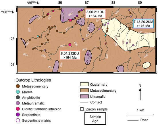
Figure 2.
Geologic map of the Marble Mountain region. After Wagner and Saucedo [75], Donato [5], and our own field observations. Topographic contours and roads from the United States Geological Survey Marble Mountain quadrangle map. Circles represent lithologies at specific outcrops, and larger squares denote thin section and detrital zircon samples. A circle with a different color in each half represents two lithologies in contact with each other. Outline colors around outcrop markers are black where no matrix was observed and purple where serpentinite matrix is found in outcrop or on the edges of blocks in float.
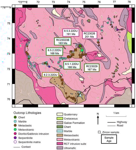
Figure 3.
Geologic map of the Rattlesnake Creek area. After Irwin et al. [42], Fraticelli et al. [76], and our own field observations. Topographic contours and roads from the United States Geological Survey Naufus Creek quadrangle map. Circles represent lithologies at specific outcrops, and larger squares denote thin section and detrital zircon samples. A circle with a different color in each half represents two lithologies in contact with each other. Outline colors around outcrop markers are black where no matrix was observed and purple where serpentinite matrix is found in outcrop or on the edges of blocks in float.
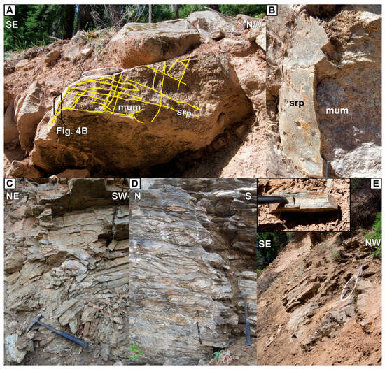
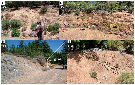
Figure 4.
Outcrop photos in the RCT. (A–E) are from the Marble Mountain area, and (F–I) are from the Rattlesnake Creek area. (A) Metaultramafic block with crosscutting veins of serpentinite. Pen circled for scale and location of (B) marked. (B) Serpentinite rind on metaultramafic block. (C) Folded gneissic metasedimentary rocks. (D) Marble block with sheared ribbon chert. (E) Outcrop of finely banded gneiss where sample 7.13.20.2KM was collected. Inset shows mineral banding. Rock hammer circled for scale. (F) Folded interbedded chert and shale. (G) Blocks mixed in a shale matrix. Colors and labels correspond to lithology: cht—chert, mv; metavolcanic; sh—shale; ss—sandstone ± shale. Sample RC23023B was collected from a sandstone block out of frame to the east. Rock hammer circled for scale. (H) Outcrop of serpentinite matrix between siliciclastic blocks. Location of (I) marked. (I) Dismembered sandstone layers in a shale matrix. Rock hammer circled for scale. cht—chert; mum—metaultramafic; srp—serpentinite.

Table 1.
Sample locations, contexts, and ages.
3.1. Marble Mountain Area
The Marble Mountain area in the north (Figure 2) has high-grade metamorphic blocks with little matrix. Block lithologies include ultramafic to metaultramafic, amphibolite, and metasedimentary. Rare block boundary exposures commonly have a mm- to cm-scale layer of serpentinite, but outcrops dominated by serpentinite are rare. The mélange is cut by gabbroic and dioritic intrusions with irregular boundaries. Foliation is weak or absent in most intrusive rocks, but they are locally lineated. Gabbro dike sample 8.06.211DU is primarily composed of anorthite with ~15% amphiboles, and lineated diorite dike sample 8.04.212DU is ~50% amphibole and ~50% anorthite and albite.
Ultramafic and metaultramafic outcrops are blocky and nonfoliated, and serpentinite veins crosscut some blocks in a mesh texture (Figure 4A,B). Olivine and orthopyroxene alteration ranges from thin crosscutting veins of serpentine mesh to almost complete replacement by serpentine and talc ± anthophyllite with associated magnetite. Previous work in the area has interpreted that anthophyllite represents a high-T metamorphic event before mélange dismemberment [12].
Metasedimentary and amphibolite blocks are strongly foliated and even gneissic with cm- to mm-scale banding. Amphibolite blocks are composed of amphibole and altered plagioclase. Clinopyroxene is locally present, and quartz is rare or absent, and these blocks are interpreted as metabasites. Metasedimentary blocks include schist, phyllite, slate, and minor quartzite and marble. Schist blocks are dominated by recrystallized quartz and banded with variously plagioclase, amphibole, biotite, chlorite, muscovite, epidote minerals, and minor calcite, titanite, garnet, and potassium feldspar (Figure 4C). Plagioclase and amphibole are abundant in some samples and scarce in others, and amphiboles are often dark green in outcrop. Minor marble is foliated with dismembered quartz ribbons with minor muscovite and may represent interlayered limestone and chert protoliths (Figure 4D). Sample 7.13.20.2KM is a gneiss block with banded light layers with abundant quartz and plagioclase, dark layers with abundant hornblende and biotite, and muscovite and epidote group minerals throughout (Figure 4E). Given the prevalence of gneissic quartz-rich metasedimentary blocks, we tentatively interpret this sample as metasedimentary.
3.2. Rattlesnake Creek Area
The Rattlesnake Creek area in the south (Figure 1 and Figure 3) is composed of subgreenschist facies blocks in a serpentinite matrix and sections of deformed stratigraphy. Block lithologies include metaultramafic rocks, metabasite, metachert, sandstone, phyllite, and marble. The 193 Ma Bear Wallow pluton [43] cuts the basement mélange on the west side of the Rattlesnake Creek area, and the 159–150 Ma Galice Formation of the Western Jurassic belt [13,66] is exposed in the southwestern and southeastern corners (Figure 3). The serpentinite matrix is often poorly exposed but is commonly found on the edges of blocks in float. Deformation fabrics and calcite veins crosscutting the serpentinite matrix rarely have a preferred orientation.
Metavolcanic blocks are dominantly weakly foliated to massive metabasite in serpentinite matrix. Metabasite blocks are composed of a plagioclase lath groundmass with amphibole, pervasive chlorite alteration, and opaque minerals. Some blocks have calcite amygdules, and secondary epidote minerals are associated with fractures. Metachert blocks are mostly gray but sometimes red and are exposed in serpentinite matrix or as larger blocks with no matrix contacts exposed. In the northeast of the Rattlesnake Creek area, a depositional relationship between chert and marble is exposed.
In the southern part of the Rattlesnake Creek area, a large body of metasedimentary rocks lacks outcrops of serpentinite. Most of the outcrop in this area is slate or phyllite with minor interlayered metasandstone and metachert. Marble is in apparent relict depositional contact with quartzite, and both have interlayered phyllite. Micaceous quartzite sample 8.2.3.22DU is dominantly quartz with minor chlorite, detrital muscovite, and feldspar (Figure 5A). Quartz grains are roughly equal proportions of mono- and polycrystalline quartz. Although the outcrops are strongly foliated and often folded (Figure 4F), there are no clear block and matrix relationships, suggesting this may be a large olistostromal block or part of a depositional cover sequence.
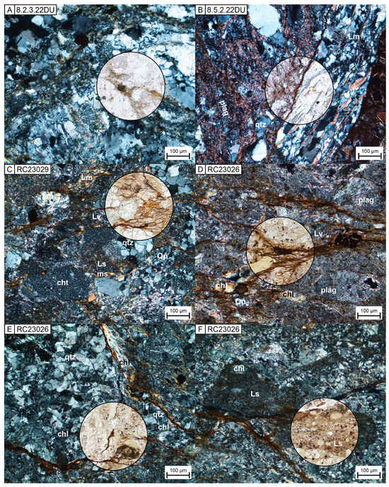
Figure 5.
Thin section photomicrographs of RCT samples from metaclastic rocks in the Rattlesnake Creek area. Images are in cross-polarized light except in each circle which shows an area in plane-polarized light. (A) Micaceous quartzite sample 8.2.3.22DU with recrystallized quartz. (B) Clast of quartz-mica schist in pebbly sandstone sample 8.5.2.22DU. (C) Wide range of clast compositions in sandstone sample RC23029. (D–F) are from volcaniclastic sample RC23026. (D) Lithic volcanic and polycrystalline quartz clasts and large plagioclase clasts. Most chlorite is fine-grained and radiating, but some coarse fragments are likely detrital. (E) Metamorphosed quartz-rich clast with radiating chlorite. Quartz grains show undulose extinction. (F) Sedimentary lithics with rounded clasts altered to chlorite. chl—chlorite; cht —chert; Lm—metamorphic lithic; Ls—sedimentary lithic; Lv—volcanic lithic; ms—muscovite; plag—plagioclase; Qp—polycrystalline quartz; qtz—quartz.
In the central part of the Rattlesnake Creek area, there is another concentration of metaclastic, metachert, and metavolcanic rocks. As in the metaclastic body in the southern part, this body is dominated by shale/slate interlayered with dismembered metasandstone and metachert. Samples RC23023B and 8.5.3.22DU (Figure 3) were collected from a block-in-matrix mélange where blocks of chert, shale, sandstone +/− shale, and metavolcanics are in a shale matrix (Figure 4G). Chert blocks have bedding or relict bedding, but one in the shale matrix mélange near sample RC23023B is brecciated chert with local metavolcanic lithics and chlorite in fractures. Samples 8.5.1.22DU, 8.5.2.22DU, RC23023B, and RC23029 were collected from pebbly and coarse sandstone beds and blocks with angular to subrounded clasts of quartz, plagioclase, and rock fragments including chert, volcanic clasts of various textures, mudstone, siltstone, and a range of schists including muscovite, chlorite, and/or epidote group minerals (Figure 5B,C). Sample RC23026 is from an outcrop of coarse-grained, massive, chloritized, volcaniclastic rock. Lithic clasts include volcanic clasts, metavolcanic clasts, and minor chert, quartzite, and mudstone (Figure 5D–F). It is in close proximity to a dioritic/gabbroic intrusion and more fine-grained sandstone and shale, although contacts between the lithologies are not exposed and no serpentinite was observed at this outcrop.
Most contacts between the metaclastic rocks and serpentinite of the basement mélange are covered (Figure 4H), but they are mostly not parallel to the metaclastic layering, more consistent with a tectonic contact than a depositional one. This is further supported by strong deformation and boudinage in some outcrops of the metcalstic rocks (Figure 4I) and more minor folding in others (Figure 4F). In the northeastern corner of the central metaclastic body, dark shale interbedded with fine-grained sandstone contains a layer of serpentinite ~2 m thick with a strong preferred orientation roughly parallel to the surrounding bedding and cut by calcite veins. This relationship suggests a tectonic shear zone where the metaclastic section was being dismembered along a bedding plane.
4. Methods
4.1. Point Counting
Modal abundances were determined for all six clastic and volcaniclastic samples that yielded zircon. Gneiss sample 7.13.20.2KM is interpreted as metasedimentary but too deformed for sedimentary point counting. We counted 450 grains in thin section from each sample using the Gazzi-Dickinson point counting method [77,78,79]. Recalculated abundances are presented in Table S1 in the Supplementary Material, and results are plotted on a ternary diagram with the tectonic fields of Dickinson et al. [80] in Figure 6.
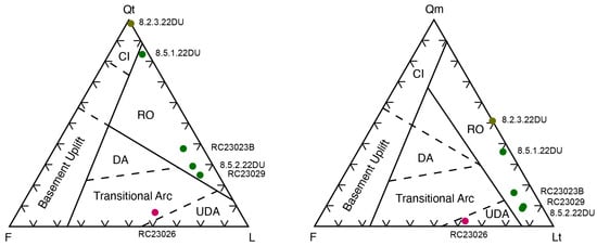
Figure 6.
Sandstone and volcaniclastic petrography ternary plots of RCT clastic and volcaniclastic samples. Provenance fields after Dickinson et al. [80]. Symbol colors are as in Figure 2 and Figure 3. CI—continental interior; DA—dissected arc; F—feldspar; L—lithics; Lt—total lithics; Qm—monocrystalline quartz; Qt—total quartz; RO—recycled orogen; UDA—undissected arc. Recalculated petrographic data are presented in Table S1.
4.2. Zircon U-Pb Geochronology
Zircons were separated by standard methods at the Arizona LaserChron Center at the University of Arizona. Ten samples yielded sufficient zircon for analysis. Backscattered electron imaging (BSE) was used to avoid inclusions in the zircons. Data were collected by laser ablation multi-collector inductively coupled plasma mass spectrometry (LA-MC-ICP-MS) [81] and reduced using the Matlab tool AgeCalc (v. 73a) [82].
The U-Pb data were filtered in two steps. First, commonly used filters were applied to data at 2σ error including both internal and external uncertainty, with discordance representing the mismatch between the 238U/206Pb and 206Pb/207Pb ages. The 204Pb limit was 600 counts per second, the 238U/206Pb and 206Pb/207Pb age uncertainty limit was 10%, the 206Pb/238U over-dispersion factor cutoff 0.6, and the 206Pb/207Pb OD factor was cutoff at 1. For analyses with 238U/206Pb age >700 Ma, the discordance limit was 20% and the reverse discordance limit was 5%. Discordance filters were not applied to younger 238U/206Pb ages because 206Pb/207Pb age errors increase with younger ages. Analyses rejected using the criteria from this first step are shown in black on concordia diagrams in Figure 7.
Some discordant analyses rejected in the first step of filtering fall along linear trends below concordia, indicating Pb loss, but 238U/206Pb and 206Pb/207Pb concordance is not useful for Phanerozoic ages because of the large error and low accuracy of 206Pb/207Pb ages. To create a second filter that would apply to all ages, we calculated non-iterative probability (NIPr) ages, minimum segmented discordance, and concordance classes [83]. This method uses all three sets of ratios (206Pb/238U, 207Pb/235U, 206Pb/207Pb) to evaluate concordance over the whole range of ages. In the second filter, analyses with concordance class 5 or higher were rejected and are shown in red in Figure 7, and the remaining accepted analyses that pass both filtering steps are shown in blue. Although there can still be hidden Pb loss [84], clearly perturbed analyses are removed for the whole range of ages with the combination of filtering steps. Full geochronology results are presented in Table S1 in the Supplementary Material. All concordia diagrams were made with IsoplotR (v. 6.8) [85].
MDAs were calculated for the Rattlesnake Creek area samples and gneiss sample 7.13.20.2KM from the Marble Mountains area which may be a paragneiss. Table 2 presents the youngest single grain (YSG), the weighted mean of the youngest cluster of three or more grains overlapping in 2σ error (YGC3+ (2σ)), the youngest statistical population (YSP) [86], and the maximum likelihood age (MLA) [87]. Weighted mean (WM) ages were calculated for igneous samples 8.06.211DU and 8.04.211DU (Table 2). All sample ages were calculated using IsoplotR (v. 6.8) [85], and plots are presented in Figure S1 in the Supplementary Material.
Samples were visually examined using cumulative distribution plots (CDPs), probability density plots (PDPs), kernel density estimates (KDEs), and histograms made in detritalPy (v. 1.4) [88]. Additionally, multi-dimensional scaling (MDS) analysis provides a visual representation of the similarity of samples with each other and potential sources or correlatives. We use the Kolmogorov–Smirnow (K-S) Test D distance as the similarity between KDEs. Using three dimensions, the metric stress value of 0.070336 from the Shepard plot represents a fair to good fit [89]. MDS plots were made in DZmds (v. 1.11) [90].


Figure 7.
Wetherill concordia diagrams with 2σ ellipses for zircon samples from the RCT. Black ellipses were rejected by the standard filtering described in the Methods section. Red ellipses were rejected by concordance class 5–7. Blue ellipses are the remaining data with concordance class 1–4. Plots were made with IsoplotR [85].


Table 2.
Maximum depositional ages, weighted mean ages, and zircon age abundances.
Table 2.
Maximum depositional ages, weighted mean ages, and zircon age abundances.
| Sample Name | YSG | YGC3+ (2σ) | YSP | MLA | n | % | ||||||||
| Age ± 2σ (Ma) | Age ± 2σ (Ma) | MSWD | n | Age ± 2σ (Ma) | MSWD | n | Age ± 2σ (Ma) | Mz | Pz | PtZ | A | pre-Mz | ||
| 7.13.20.2KM | 156.0 ± 12.6 | 175.2 ± 1.3 | 0.86 | 41 | 175.8 ± 1.2 | 1.1 | 44 | 176.0 ± 1.6 | 79 | 97.5 | 0.0 | 2.5 | 0.0 | 2.5 |
| RC23026 | 184.7 ± 17.0 | 200.9 ± 4.2 | 1.4 | 12 | 199.8 ± 4.3 | 1.3 | 10 | 201.1 ± 4.6 | 18 | 66.7 | 5.6 | 27.8 | 0.0 | 33.3 |
| 8.5.3.22DU | 179.5 ± 7.5 | 189.27 ± 0.71 | 0.62 | 97 | 191.01 ± 0.61 | 1 | 133 | 191.61 ± 0.67 | 185 | 99.5 | 0.0 | 0.5 | 0.0 | 0.5 |
| 8.5.1.22DU | 163.9 ± 4.3 | 168.6 ± 1.7 | 1.4 | 9 | 167.7 ± 1.9 | 1.1 | 7 | 168.6 ± 3.2 | 193 | 15.0 | 19.2 | 56.5 | 9.3 | 85.0 |
| 8.5.2.22DU | 164.9 ± 5.1 | 168.7 ± 1.8 | 1.5 | 9 | 168.1 ± 1.8 | 1.1 | 8 | 168 ± 3 | 189 | 12.7 | 29.6 | 49.2 | 8.5 | 87.3 |
| RC23029 | 164.7 ± 4.1 | 167.7 ± 0.8 | 2.1 | 9 | 166.6 ± 1.1 | 1.2 | 6 | 167.4 ± 1.5 | 204 | 9.8 | 17.2 | 67.2 | 5.9 | 90.2 |
| RC23023B | 160.6 ± 4.6 | 164.4 ± 1.4 | 1.4 | 9 | 162.3 ± 1.9 | 1.1 | 5 | 164.1 ± 2.3 | 135 | 21.5 | 23.0 | 55.6 | 0.0 | 78.5 |
| 8.2.3.22DU | 467.4 ± 17.9 | - | - | - | - | - | - | - | 158 | 1.3 | 0.6 | 89.2 | 8.9 | 98.7 |
| Sample Name | Weighted mean | n | % | |||||||||||
| Age ± 2σ (Ma) | MSWD | n | Mz | Pz | PtZ | A | pre-Mz | |||||||
| 8.06.211DU | 164.09 ± 0.64 | 4.4 | 60 | 61 | 100.0 | 0.0 | 0.0 | 0.0 | 0.0 | |||||
| 8.04.212DU | 164.3 ± 1.0 | 6.6 | 20 | 23 | 91.3 | 0.0 | 8.7 | 0.0 | 8.7 | |||||
A—Archean; MLA: maximum likelihood age [87]; MSWD—mean square of weighted deviates; Mz—Mesozoic; n—number of analyses; PtZ—Proterozoic; Pz—Paleozoic; YGC3+ (2σ)—youngest grain cluster of three or more ages overlapping within 2σ; YSG—youngest single grain; YSP—youngest statistical population [86].
5. Results
Three samples from the Marble Mountain area and seven from the Rattlesnake Creek area yielded sufficient zircon for analysis (Figure 1 and Figure 3), producing 1245 new ages from the RCT. Here, we report and discuss weighted means ages for igneous samples and both MLA and YSP MDAs for detrital samples. All errors are reported at 2σ.
5.1. Marble Mountain Area
Three samples from the Marble Mountain area in the north yielded zircon (Figure 1 and Figure 8). Sample 7.13.20.2KM (YSP: 175.8 ± 1.2 Ma, MLA: 176.0 ± 1.6 Ma) is a gneiss with a shoulder peak at 194 Ma and only two grains (582 Ma and 1180 Ma) >250 Ma. Sample 8.06.211DU (WM: 164.09 ± 0.64 Ma) is a gabbro dike, and all but one outlier grain are included in the 164 Ma weighted mean age. Sample 8.04.212DU (WM: 164.3 ± 1.0 Ma) is a lineated diorite dike with four older ages at 199, 247, 1293, and 1315 Ma.
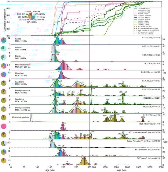
Figure 8.
Zircon data for all RCT samples in this study and literature data from the RCT cover sequence and nearby terranes. Note the change in the horizontal axis scale at 300 Ma. Solid lines are from this study, and dashed lines are from the literature. Cumulative distribution functions (CDFs), kernel density estimates (KDEs), probability density plots (PDPs), histograms, and pie charts of age ranges. KDEs with an optimized variable bandwidth are shown in colored lines, and PDPs are shown as filled curves. Pie charts and PDPs are colored by age. Counts for histograms are on the left side of the plot for ages <300 Ma and on the right side for ages >300 Ma. Plots were made in detritalPy [88]. 1 Wright and Wyld [4]; 2 LaMaskin et al. [13]; 3 Surpless et al. [67]; 4 Scherer and Ernst [20]; 5 Ernst et al. [18]; N—number of samples in compilation; n—number of analyses <300 Ma/total number of analyses.
5.2. Rattlesnake Creek Area
In the Rattlesnake Creek area of the southernmost RCT, seven sedimentary, metasedimentary, and metavolcaniclastic samples yielded zircon (Figure 1, Figure 3 and Figure 8). The oldest sample is metavolcaniclastic sample RC23026 (YSP: 199.8 ± 4.3 Ma, MLA: 201.1 ± 4.6 Ma) from the southern RCT which yielded 18 grain ages. The main peak at ~201 Ma comprises 67% of the ages, but 33% are pre-Mesozoic and as old as 1874 Ma. Sample 8.5.3.22DU (YSP: 191.01 ± 0.61 Ma, MLA: 191.61 ± 0.67 Ma) is a metachert in the southern RCT with only one outlier grain at 1836 Ma.
Sample 8.5.1.22DU (YSP: 167.7 ± 1.9 Ma, MLA: 168.6 ± 3.2 Ma) is a sandstone with a main peak at 174 Ma, a shoulder peak at 188 Ma, and older peaks at 251, ~1075, ~1400, and ~1775 Ma. Ages are 15% Mesozoic, 19% Paleozoic, 57% Proterozoic, and 9% Archean. Sample 8.5.2.22DU (YSP: 168.1 ± 1.8 Ma, MLA: 168 ± 3 Ma) is a pebbly sandstone with a main peak at 168 Ma with a tail to 200 Ma and older peaks at 379 and ~1850 Ma. Ages are 12% Mesozoic, 29% Paleozoic, 51% Proterozoic, and 8% Archean. Sample RC23029 (YSP: 166.6 ± 1.1 Ma, MLA: 167.4 ± 1.5 Ma) is a sandstone with a main peak at 169 Ma and older peaks at 255, 361, and 1760 Ma. Ages are 10% Mesozoic, 17% Paleozoic, 67% Proterozoic, and 6% Archean. Sample RC23023B (YSP: 162.3 ± 1.9 Ma, MLA: 164.1 ± 2.3 Ma) is a sandstone with a main peak at 167 Ma and an older peak at 253 Ma. Ages are 21% Mesozoic, 23% Paleozoic, 56% Proterozoic, and 0% Archean.
Finally, sample 8.2.3.22DU is a micaceous quartzite with age peaks at 1096, 1050, 1235, 1300, 1440, 1733, 1746, and 2674 Ma. There are four scattered young ages at 76, 78, 467, and 655 Ma. The Cretaceous ages are younger than tectonic events in the WPzTrB and are likely a result of contamination during mineral separation. Excluding these two young ages, ages are 0% Mesozoic, <1% Paleozoic, 91% Proterozoic, and 8% Archean. The lack of a consistent young population and the large proportion of Proterozoic and Archean zircons indicates that an MDA calculation would not reflect the age of incorporation into the RCT.
6. Discussion
6.1. RCT Age and Provenance
Detrital zircon ages from the RCT indicate that there are significant differences in time and space. All but one sedimentary and metasedimentary samples collected from the RCT which yielded sufficient zircon are from the southernmost RCT. Metavolcaniclastic sample RC23026 has the oldest MDA at ~201 Ma (Table 2), coeval with the quartz diorites (207–193 Ma) in the RCT intrusive suite [4]. Since this sample is volcaniclastic and the RCT intrusive suite arc magmatism was active as young as 193 Ma, we interpret that it deposited during active volcanism and that the MDA is close to the true depositional age. Although this sample only yielded 18 ages, six of them (33%) are scattered between 250 and 1874 Ma, consistent with a continental source, but there are not enough ages to positively link with any particular continent or region. A continental source component is further supported by the presence of sedimentary and quartz-rich metamorphic clasts (Figure 6). Because contacts with other lithologies are not exposed, it is unclear if sample RC23026 is a block in the serpentinite matrix or part of the central metaclastic body in the Rattlesnake Creek area. The abundance of volcanic lithic clasts and the 201 Ma MDA suggest deposition of an Early Jurassic cover sequence on the RCT basement mélange proximal to the RCT intrusive suite. Pre-Mesozoic zircon ages are interpreted to signify a sediment pathway from a continental source to the RCT at the time of active RCT magmatism. Metachert sample 8.5.3.22DU has an MDA of ~191 Ma (Table 2), younger than documented ages in the RCT suite. Only one of the 185 ages is older than this age peak, so a continental source is not required. Zircon grains in chert are more likely to be sourced from volcanic airfall, so the MDA is likely close to the true depositional age. The metachert is a block from an interpreted olistostromal deposit with minor shale matrix, so the original depositional context is unclear. Samples RC23026 and 8.5.3.22DU both plot on the left side of the MDS plot with the RCT intrusive suite (Figure 9).

Figure 9.
Multi-dimensional scaling analysis of all RCT samples in this study and literature data from the RCT cover sequence and nearby terranes. Pie charts are the same as in Figure 8. Solid black arrows represent closest similarity and dashed gray arrows represent second most similar. Arrows are not visible where pie charts overlap. The Shepard plot and stress value are shown in the upper left. Plots were made in DZmds [90] with metric stress and Kolmogorov–Smirnow (K-S) Test D distance as the similarity between KDEs.
Gneiss sample 7.13.20.2KM in the Marble Mountain area (Figure 2) has an MDA of ~176 Ma (Table 2), similar to the oldest hornblende ages in the WHT [24,25], and a shoulder peak at ~194 Ma, consistent with the youngest ages of the RCT intrusive suite [4]. This gneiss is interpreted as metasedimentary based on the abundance of quartz in gneissic blocks, but more work is needed to distinguish between an orthogneiss and a paragneiss. One possible interpretation of the ages for sample 7.13.20.2KM is that the gneiss protolith was deposited on the RCT, incorporating zircon from the active WHT arc and the eroding RCT intrusive suite. However, the concordia plots (Figure 7) show that ages are spread for all three samples from the Marble Mountain area, potentially indicating Pb loss during one or more later phase of metamorphism [29]. In this case, the shoulder peak at 194 Ma may better represent the age of the protolith which may have been part of an Early Jurassic RCT cover sequence. Also in the Marble Mountain area, gabbro dike sample 8.06.211DU and lineated diorite dike sample 8.04.212DU have weighted mean ages of ~164 Ma, overlapping with the extensive 167–156 Ma Wooley Creek intrusive suite [69]. However, the MSWD values (4.4 and 6.6) indicate the zircons in our dike samples may also be affected by Pb loss to an extent, so the true intrusion age may be >164 Ma. All three samples from the Marble Mountains area plot in the lower center of the MDS plot, although gneiss sample 7.13.20.2KM plots closer to the RCT intrusive suite (Figure 9).
In the Rattlesnake Creek area to the south (Figure 3), sandstone samples 8.5.1.22DU, 8.5.2.22DU, RC23029, and RC23023B have MDAs 168–163 Ma and 79–90% pre-Mesozoic grains consistent with a North American provenance (Table 2). Because magmatism was active throughout the Middle Jurassic and volcanic lithic clasts are abundant in the sandstones, we interpret that the MDAs closely approximate the true depositional ages. These samples had good zircon yield (n = 135–204) and were deposited shortly after WHT and Ironside Mountain batholith magmatism and thus after accretion of the RCT to North America. Sample RC23023B (MDA~163 Ma) is a pebbly sandstone block in a shale matrix that is not strongly tectonized (Figure 4F), more consistent with sedimentary mélange formation by mass wasting than tectonic incorporation. Detrital zircon ages agree with those LaMaskin et al. [13] documented in the cover sequence ~15 km to the east (Figure 1 and Figure 8) and plot closely together on the right side of the MDS plot (Figure 9). We interpret that our Middle Jurassic sandstone samples represent a dismembered western extent of the Middle to earliest Late Jurassic cover sequence.
Micaceous quartzite sample 8.2.3.22DU has 99% pre-Mesozoic detrital zircon ages (Table 2). Notably absent is the 360–380 Ma age peak present in most of the young southern samples and the RCT cover sequence (Figure 8). Older age peaks match well with those in the four Middle-Late Jurassic cover sequence samples and the RCT cover sequence [13] (Figure 7 and Figure 8). Sample 8.2.3.22DU is likely an olistostromal block, but its ages are inconsistent with the large olistostromal blocks in the EHT mélange which are dominated by ages >1500 Ma [21] and must represent a different North American source. Fossil ages from limestone and marble blocks in the area are interpreted as Permian or early Mesozoic, Late Triassic or Early Jurassic, and undetermined [16] (localities 59 and 60). Since the depositional age of sample 8.2.3.22DU is undetermined, it is unclear if there are significant age outliers within the southern zone of siliciclastic material (Figure 3). Although the lithologies are similar to the Middle Jurassic central metaclastic body in the Rattlesnake Creek area, the southern metaclastic body is more metamorphosed, permissibly Early Jurassic, and could be further evidence of the early proximity of the RCT to North America. More age constraints are necessary to date the southern metaclastic body and its incorporation into the RCT.
Overall, siliciclastic rocks are a minor but informative component of the RCT. The distribution of metaclastic zircon ages could be an artifact of limited sampling, but data from this study and LaMaskin et al. [13] suggest that the RCT incorporated 33% continental zircon at ~201 Ma, effectively none at ~191 Ma, and 79–93% from 170 to 161 Ma. North Fork terrane sandstones and Eastern Hayfork terrane matrix sandstones to the east have similar age peaks to the Middle Jurassic cover sequence (Figure 8), although all samples have low zircon yield (n = 15–67) [18,20], making it challenging to correlate them. RCT formation overlaps with 225–180 Ma deposition in the North Fork terrane [14,20] and begins approximately coeval with the end of Eastern Hayfork terrane subduction accretion in the Late Triassic [16,18]. Interestingly, the Galice Formation is at the center of all MDS groups (Figure 9), consistent with the interpretation that the WPzTrB was one of the sources of Galice Formation zircon [13,66,67].
6.2. Subduction Vergence
Many tectonic models for the Early Jurassic margin of western North America include the Mezcalera plate subducting to the east beneath North America and to the west beneath an intraoceanic arc [8,10,11,45]. However, this does not seem to be consistent with the EHT and RCT subduction complexes. We might expect opposite vergence deformation fabrics or a zone of mixing as the two terranes came into contact. However, after ~200 Ma, there are no similarities in age or composition of blocks in the mélanges, and both terranes have generally east-dipping fabrics. The southern EHT in particular is characterized by large quartz-rich blocks with detrital zircon ages >1500 Ma [21], a pattern not documented anywhere in the RCT. We might also expect to see a larger proportion of material accreted into subduction complexes as the narrowing ocean filled with sediment shed from two approaching terranes, but the age of collision between the EHT and RCT is not well documented by siliciclastic or volcanic blocks in either mélange. If the RCT formed distal to North America, subduction accretion in the EHT would have continued well after initiation of the RCT intrusive suite as the ocean between the trenches closed. Instead, the minimal overlap in ages of accreted blocks and presence of continental input to the RCT at ~201 Ma is more consistent with the initiation of east-dipping subduction beneath the RCT marginal to North America. As a result, the Sigloch and Mihalynuk [10,11] Late Jurassic-Cretaceous suture model is not supported by the geology in the Klamath Mountains and further challenges the validity of this model along strike to the north and south along the Cordilleran margin [13,66,67].
6.3. The RCT Cover Sequence
In the Rattlesnake Creek area, we propose that there is evidence for two phases of cover sequence deposition, one in the Early Jurassic and one in the Middle Jurassic to earliest Late Jurassic. Volcanic and volcaniclastic rocks are only a small component of the Rattlesnake Creek area cover sequence in contrast with the mostly volcanic Salt Creek and Dubakella Mountain assemblages of the cover sequence defined by Wright and Wyld [4] ~15 km to the east. Volcaniclastic sample RC23026 has an MDA of ~201 Ma, consistent with Early Jurassic cover sequence deposition during RCT intrusive suite magmatism and the crosscutting relationships documented farther east [4,41]. Our four youngest samples agree well with the 170–161 Ma MDAs and older ages found by LaMaskin et al. [13] to the east. The age peaks at ca. 1.1, 1.4, and 1.75 Ga in the RCT cover sequence are a strong indicator of southwestern Laurentia provenance [91,92,93,94,95], and LaMaskin et al. [13] determined that the provenance of the RCT cover sequence is most consistent with a mixture of sediment from older Klamath and Sierra Nevada terranes, transcontinental sources, and southwestern US sources. Outcrop lithologies and our geochronology suggest that the cover sequence in the Rattlesnake Creek area is dominantly Middle-Late Jurassic with limited exposure of the Early Jurassic sequence.
Poorly exposed relationships between the basement mélange and sedimentary rocks in the Rattlesnake Creek area are generally not parallel to layering and appear to be tectonic rather than depositional. Samples 8.5.3.22DU, RC23023B, and 8.2.3.22DU are also interpreted as olistostromes. We propose that most original contacts between the cover sequences and the basement mélange have been disrupted by tectonic and sedimentary processes which we discuss more in Section 6.4 below. Because of this disruption, there is a possibility that the cover sequences were originally deposited elsewhere and later incorporated into the RCT mélange. However, sample RC23026 was likely deposited proximal to the RCT intrusive suite as discussed in Section 6.1 above, and there are no known correlatives to the Middle-Late Jurassic cover sequence deposits associated with any another Klamath terrane. We interpret that all cover sequence deposits were originally depositional on the RCT.
In the Marble Mountain area, metasedimentary blocks are abundant. Although these include marble and metachert which may represent blocks of ocean plate stratigraphy, there also blocks of schist and gneiss. Gneiss sample 7.13.20.2KM is the only basement block which yielded zircon, but it was likely affected by Pb loss during metamorphism as discussed in Section 6.1 above. If the protolith age is represented by the 194 Ma age peak, this may be evidence for Early Jurassic cover sequence in the central RCT. Other rocks such as the Lake Mountain metasediments of Barrows [38] may also be equivalent to the cover sequence, but more work is needed to better understand the ages and protoliths of metasedimentary blocks in the central RCT.
6.4. Mélange Formation in the RCT
The RCT has undergone multiple phases of mélange formation and dismemberment, but how blocks younger than the RCT intrusive suite (<193 Ma) were incorporated is unclear. Significant mélange dismemberment and mixing predates the RCT intrusive suite which crosscuts the basement mélange, and most mélange blocks are dismembered ocean plate stratigraphy. Initial mélange formation has been interpreted to have originated in an oceanic fracture zone which was reactivated as a subduction zone, forming the RCT intrusive suite [4]. These relationships require that the initial RCT mélange was in an upper plate position above a subduction zone in the Late Triassic to Early Jurassic. Blocks of the intrusive suite are also found within the basement mélange, so mélange formation must have continued after arc magmatism [4] perhaps as late as earliest Late Jurassic based on fossils [16] and zircon ages of the Middle-Late Jurassic cover sequence ([13] and this study).
6.4.1. Subduction Accretion
Suprasubduction mélanges often form by subduction accretion at the trench. In this setting, classic subduction zone high-pressure, low-temperature metamorphism might be expected, but blueschist has not been documented in any portion of the RCT. However, the EHT, which is often interpreted as a subduction complex [17,21,22,96,97], contains little blueschist, and there are only a few documented locations with high-temperature, low-pressure metamorphism in the subduction complex in the Yarlung suture zone between India and Asia [98,99,100]. Blueschist facies metamorphism is diagnostic of subduction accretion, but its absence does not necessarily preclude subduction accretion. That being said, convergence may have been oblique at times [14,56], and the magmatic gap between the RCT intrusive suite and Western Hayfork terrane magmatism may indicate a period of transpression. Oceanic blocks could have accreted with only minor underthrusting and/or strain could have been accommodated in the weak basement mélange, disrupting Early Jurassic intrusive and stratigraphic relationships in the RCT. While there is no concrete evidence for subduction accretion in the RCT, we caution against rejecting this mechanism of mélange formation based on metamorphic conditions alone, especially since much of the central RCT has experienced multiple episodes of metamorphism [12,28,29,60].
6.4.2. Siskiyou Thrusting
The Salt Creek thrust placed the WHT over the RCT before being intruded by the ~170 Ma Ironside Mountain Batholith [68] (Figure 1). This episode of thrusting could have contributed to dismemberment of the existing basement mélange, but it is unlikely that new blocks were incorporated during this phase of deformation. With the possible exception of gneiss sample 7.13.20.2KM in the Marble Mountain, no documented blocks in the RCT are consistent with incorporation of the WHT, and the Middle-Late Jurassic cover sequence postdates the Salt Creek thrust. However, Siskiyou thrusting also structurally buried much of the RCT, making it challenging to deposit and/or incorporate new material without significant exhumation.
6.4.3. Jurassic Rifting
Extension in the RCT began as early as ca. 173–170 Ma [59,64,70], and intra-arc extension formed the 164–162 Ma Josephine ophiolite [57,58,71]. The Onion Camp complex within the Western Jurassic belt has been interpreted as a rifted portion of the RCT and is associated with the Late Jurassic Fiddler Mountain olistostrome [59]. Rifting could have exhumed the basement mélange and created steep topographic slopes that promoted mass wasting. Olistostromal deposits in the Rattlesnake Creek area are older and more continental than the Fiddler Mountain olistostrome [59], consistent with the Rattlesnake Creek area being on the eastern edge of the rift basin, more proximal to the continent. We agree with the interpretation of LaMaskin et al. [13] of an extensional rift setting for deposition of the Middle-Late Jurassic cover sequence. However, the lack of clear depositional relationships between the cover sequence and the basement mélange and evidence of mixing m-scale blocks by sedimentary processes may indicate that much of the cover sequence and blocks with Middle Jurassic fossils were dismembered by rifting and mass wasting. Subsequent closure of the Josephine ophiolite basin and thrusting of the Nevadan orogeny may have further disrupted the Middle-Late Jurassic cover sequence.
6.5. Proposed Tectonic Model
The RCT basement mélange may have begun as an oceanic transform system which was reactivated as a subduction zone (Figure 10A), driving the 207–193 Ma RCT intrusive suite magmatism which crosscuts the basement mélange and a section interpreted as the RCT cover sequence [4]. At ~201 Ma, volcaniclastic sample RC23026 with metamorphic clasts and 33% continental detrital zircon ages was deposited in the southern RCT (Figure 1 and Figure 3), indicating a sediment pathway from North America while final subduction accretion was occurring in the EHT mélange (Figure 10B). This sample is consistent with an initial Early Jurassic phase of cover sequence deposition [4]. A ~191 Ma metachert incorporated into the southern RCT contains no evidence of continental input, potentially indicating disruption of the sediment pathway to the RCT after RCT intrusive suite magmatism (Figure 10B). A metasedimentary gneiss in the northern study area has an MDA of 176 Ma and a shoulder peak at ~194 Ma. This represents either incorporation of Western Hayfork terrane and RCT intrusive suite zircon or a block of the Early Jurassic cover sequence that experienced Pb loss during Middle-Late Jurassic metamorphism. Regardless, there are only two pre-Mesozoic ages, so a continental source is not required. Magmatic quiescence between the 207–193 Ma RCT intrusive suite and Western Hayfork magmatism may indicate a period of transpression in the Early Jurassic.
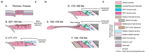
Figure 10.
Tectonic model for the development of the RCT in the Rattlesnake Creek area (Figure 1). After Wright and Wyld [4] and LaMaskin et al. [13]. (A) Permian-Triassic: The RCT basement mélange develops in an oceanic fracture zone. Subduction initiates sometime in the Late Triassic. (B) 207–193 Ma: Quartz-diorite of the RCT intrusive suite cuts the basement mélange and an Early Jurassic volcanic cover sequence. A volcaniclastic block records minor continental sediment input at ~201 Ma. A change in plate motions may have led to a period of oblique subduction and the end of RCT intrusive suite magmatism. (C) 177–171 Ma: WHT magmatism begins on the amalgamated RCT and EHT. The SCT initiates along the interpreted original depositional contact between the WHT and RCT, and the WPT thrusts the EHT over the WHT. Rifting begins as early as 173 Ma, and the Middle-Late Jurassic RCT cover sequence begins depositing sediment with significant continental input. (D) 170–166 Ma: The Ironside Mountain batholith cuts the WPT and is sheared along the SCT. WHT magmatism likely ends before intrusion of the 170 Ma Ironside Mountain Batholith, Wooley Creek suite magmatism begins farther north, and RCT cover sequence deposition continues throughout. (E) 164–155 Ma: Extension rifts the RCT, forming the Josephine ophiolite and the Rogue–Chetco arc. The Wooley Creek intrusive suite continues intruding the WPzTrB. Rifting may dismember older RCT cover sequence deposits and create accommodation space for deposition to continue until at least 161 Ma. The Galice Formation deposits in the rift basin. (F) 155–150 Ma: The rift basin closes during the Nevadan orogeny, although the Galice Formation continues depositing, and the RCT is thrust over the Galice Formation along the OF. Renewed compression further deforms the RCT cover sequence. OF—Orleans Fault; SCT—Salt Creek trhust; TST—Twin Sisters thrust; WPT—Wilson Point thrust.
After accretion of the RCT to the continental margin, the 177–168 Ma WHT arc is interpreted to have formed on the amalgamated RCT and EHT [26], and the hinterland was uplifted along west-verging thrust faults during the Siskiyou contractional event, likely indicating the resumption of eastward subduction beneath the RCT along the western margin of North America (Figure 10C). The crosscutting 170 Ma Ironside Mountain batholith places a minimum constraint on the timing of slip along the Wilson Point thrust which thrust the EHT over the WHT and the Salt Creek thrust which thrust the WHT over the RCT [68] (Figure 10D). Rifting began as early as 173 Ma (Figure 10C) and culminated with the formation of the Josephine ophiolite at 164–162 Ma (Figure 10E). At 170–161 Ma, the Middle-Late Jurassic RCT cover sequence was deposited on top of the southern RCT basement mélange, potentially on basement exposed by rifting (Figure 10D,E). The nearby EHT and NFT likely contributed some sediment to the cover sequence (Figure 9), but significant Proterozoic and Archean ages (Table 2; Figure 8) suggest additional transcontinental and southwest US sources [13]. In the cover sequence ~15 km east of the Rattlesnake Creek area (Figure 1), Wright and Wyld [4] interpreted deposition in rift basins that were later inverted. More detailed mapping is needed to determine whether the rifting occurred during the Early Jurassic or Middle-Late Jurassic phase of the cover sequence deposition and how much the cover sequence was disrupted by later deformation. Dikes in the central RCT crosscut the basement mélange prior to 164 Ma.
At 164–162 Ma, the RCT rifted apart, forming the Josephine ophiolite [57,58,71] and dismembering the RCT cover sequence by mass wasting. Micaceous quartzite sample 8.2.3.22DU with 99% pre-Mesozoic ages is likely an olistostromal block, and the timing of incorporation into the RCT is unknown, but sample RC23023B from a sedimentary mélange indicates sedimentary mixing after 163 Ma. The Galice Formation was also deposited in this rift basin (Figure 10E) and as compression resumed during the Nevadan orogeny (Figure 10F). The RCT cover sequence may have been further deformed and dismembered during basin inversion during the Nevadan orogeny. Both generations of RCT cover sequence are now exposed as dismembered blocks in the southern RCT.
7. Conclusions
Blocks in the RCT basement mélange record continental input at ~201 Ma (33%) and effectively none at ~191 Ma. These data are inconsistent with models including the RCT as part of a large, continuous, west-dipping subduction zone or the western margin of a subducting Mezcalera plate. Instead, our preferred interpretation is that the RCT developed marginal to North America above an east-dipping subduction zone. In the southern RCT, we interpret a ~201 Ma volcaniclastic block with metamorphic clasts and pre-Mesozoic grains as part of Early Jurassic RCT cover sequence and a larger extent of dismembered clastic and metaclastic rocks equivalent to the Middle-Late Jurassic RCT cover sequence. Blocks <193 Ma were likely dismembered and incorporated into the basement mélange by tectonic and sedimentary processes during rifting of the 164–162 Ma Josephine ophiolite and later Nevadan compression. More work is needed to understand the multiple phases of deposition recorded in the RCT cover sequence and how the RCT may correlate along strike beyond the Klamath Mountains.
Supplementary Materials
The following supporting information can be downloaded at https://www.mdpi.com/article/10.3390/geosciences16010030/s1, Table S1: Sample locations, petrography, and geochronology; Figure S1: Plots of MDAs and igneous ages.
Author Contributions
Conceptualization, D.U. and K.M.; Data curation, D.U., K.M. and J.D.; Formal analysis, D.U., K.M. and J.D.; Funding acquisition, D.U. and K.M.; Investigation, D.U., K.M. and J.D.; Methodology, D.U. and K.M.; Project administration, K.M.; Resources, K.M.; Supervision, K.M.; Validation, D.U. and K.M.; Visualization, D.U. and K.M.; Writing—original draft, D.U. and J.D.; Writing—review and editing, D.U. and K.M. All authors have read and agreed to the published version of the manuscript.
Funding
This research was funded by a GSA Graduate Student Research Grant awarded to D.U. and California State University Fullerton funding awarded to K.M. Analyses were conducted at the Arizona LaserChron Center, which is supported by NSF EAR-1338583.
Data Availability Statement
The original contributions presented in this study are included in the article/Supplementary Material. Further inquiries can be directed to the corresponding author(s).
Acknowledgments
We thank Calvin Barnes and Derek Beal for helpful discussions on Klamath geology and Joana Camargo Ramirez for assistance in the field. We also thank Klamath and Shasta-Trinity National Forests for field support and the Arizona LaserChron Center staff for their assistance in geochronology data collection and reduction. Constructive reviews by four anonymous reviewers significantly improved the manuscript.
Conflicts of Interest
The authors declare no conflicts of interest. The funders had no role in the design of the study; in the collection, analyses, or interpretation of data; in the writing of the manuscript; or in the decision to publish the results.
Abbreviations
The following abbreviations are used in this manuscript:
| A | Archean |
| BSE | Backscattered electron |
| CDP | Cumulative distribution plot |
| chl | Chlorite |
| CI | Continental interior |
| CMZ | Condrey Mountain shear zone |
| DA | Dissected arc |
| EHT | Eastern Hayfork terrane |
| F | Feldspar |
| IAT | Island arc tholeiite |
| KDE | Kernel density estimation |
| LA-MC-ICP-MS | Laser ablation multi-collector inductively coupled plasma mass spectrometry |
| L | Lithics |
| Lm | Metamorphic lithic |
| Ls | Sedimentary lithic |
| Lt | Total lithics |
| Lv | Volcanic lithic |
| MDA | Maximum depositional age |
| MDS | Multi-dimensional scaling |
| MLA | Maximum likelihood age |
| MORB | Mid-ocean ridge basalt |
| ms | Muscovite |
| MSWD | Mean square of weighted deviates |
| Mz | Mesozoic |
| N | Number of samples in a compilation |
| n | Number of analyses |
| NFT | North Fork terrane |
| NIPr | Non-iterative probability |
| OF | Orleans fault |
| OIB | Ocean island basalt |
| PDP | Probability distribution plot |
| plag | Plagioclase |
| PtZ | Proterozoic |
| Pz | Paleozoic |
| Qm | Monocrystalline quartz |
| Qp | Polycrystalline quartz |
| Qt | Total quartz |
| qtz | quartz |
| RCT | Rattlesnake Cree terrane |
| RO | Recycled orogen |
| SCRT/SRT | Soap Creek Ridge thrust/Salmon River thrust |
| SCT | Salt Creek thrust |
| SFT | Stuart Fork terrane |
| ST | Siskiyou thrust |
| TST | Twin Sisters thrust |
| TT | Trinity thrust |
| ttg | tonalite-trondhjemite-granodiorite |
| UDA | Undissected arc |
| WHT | Western Hayfork terrane |
| WPB | Within plate basalt |
| WPT | Wilson Point thrust |
| WPzTrB | Western Paleozoic and Triassic belt |
| YGC3+ (2σ) | Youngest grain cluster of three or more grains overlapping in 2σ error |
| YSG | Youngest single grain |
| YSP | Youngest statistical population |
References
- Snoke, A.W.; Barnes, C.G. The Development of Tectonic Concepts for the Klamath Mountains Province, California and Oregon. In Geological Studies in the Klamath Mountains Province, California and Oregon: A Volume in Honor of William P. Irwin; Geological Society of America: Boulder, CO, USA, 2006; ISBN 978-0-8137-2410-2. [Google Scholar]
- Irwin, W.P. Terranes of the Western Paleozoic and Triassic Belt in the Southern Klamath Mountains, California. In Geological Survey Research 1972; U.S. Geological Survey: Reston, VA, USA, 1972; pp. C103–C111. [Google Scholar]
- Irwin, W.P. Correlation of the Klamath Mountains and Sierra Nevada; Open-File Report; U.S. Geological Survey: Reston, VA, USA, 2003; Report 2002–490.
- Wright, J.E.; Wyld, S.J. The Rattlesnake Creek Terrane, Klamath Mountains, California: An Early Mesozoic Volcanic Arc and Its Basement of Tectonically Disrupted Oceanic Crust. GSA Bull. 1994, 106, 1033–1056. [Google Scholar] [CrossRef]
- Donato, M.M. Evolution of an Ophiolitic Tectonic Mélange, Marble Mountains, Northern California Klamath Mountains. GSA Bull. 1987, 98, 448–464. [Google Scholar] [CrossRef]
- Miller, D.E.; Ernst, W.G. Deformation and Metamorphism of the Marble Mountain and Pony Camp Areas, Western Triassic and Paleozoic Belt, Central Klamath Mountains, Northwestern California. Int. Geol. Rev. 1998, 40, 411–451. [Google Scholar] [CrossRef]
- Frost, C.D.; Barnes, C.G.; Snoke, A.W. Nd and Sr Isotopic Data from Argillaceous Rocks of the Galice Formation and Rattlesnake Creek Terrane, Klamath Mountains: Evidence for the Input of Precambrian Sources. In Geological Studies in the Klamath Mountains Province, California and Oregon: A Volume in Honor of William P. Irwin; Geological Society of America: Boulder, CO, USA, 2006; ISBN 978-0-8137-2410-2. [Google Scholar]
- Dickinson, W.R. Accretionary Mesozoic–Cenozoic Expansion of the Cordilleran Continental Margin in California and Adjacent Oregon. Geosphere 2008, 4, 329–353. [Google Scholar] [CrossRef]
- Dickinson, W.R. Phanerozoic Palinspastic Reconstructions of Great Basin Geotectonics (Nevada-Utah, USA). Geosphere 2013, 9, 1384–1396. [Google Scholar] [CrossRef]
- Sigloch, K.; Mihalynuk, M.G. Intra-Oceanic Subduction Shaped the Assembly of Cordilleran North America. Nature 2013, 496, 50–56. [Google Scholar] [CrossRef] [PubMed]
- Sigloch, K.; Mihalynuk, M.G. Mantle and Geological Evidence for a Late Jurassic–Cretaceous Suture Spanning North America. GSA Bull. 2017, 129, 1489–1520. [Google Scholar] [CrossRef]
- Donato, M.M. Metamorphism of an Ophiolitic Tectonic Mélange, Northern California Klamath Mountains, USA. J. Metamorph. Geol. 1989, 7, 515–528. [Google Scholar] [CrossRef]
- LaMaskin, T.A.; Rivas, J.A.; Barbeau, D.L.; Schwartz, J.J.; Russell, J.A.; Chapman, A.D. A Crucial Geologic Test of Late Jurassic Exotic Collision versus Endemic Re-Accretion in the Klamath Mountains Province, Western United States, with Implications for the Assembly of Western North America. GSA Bull. 2022, 134, 965–988. [Google Scholar] [CrossRef]
- Ernst, W.G.; Snow, C.A.; Scherer, H.H. Contrasting Early and Late Mesozoic Petrotectonic Evolution of Northern California. GSA Bull. 2008, 120, 179–194. [Google Scholar] [CrossRef]
- Ando, C.J.; Irwin, W.P.; Jones, D.L.; Saleeby, J.B. The Ophiolitic North Fork Terrane in the Salmon River Region, Central Klamath Mountains, California. GSA Bull. 1983, 94, 236–252. [Google Scholar] [CrossRef]
- Irwin, W.P.; Blome, C.D. Fossil Localities of the Rattlesnake Creek, Western and Eastern Hayfork, and North Fork Terranes of the Klamath Mountains; U.S. Geological Survey: Reston, VA, USA, 2004; p. 50.
- Hacker, B.R.; Ernst, W.G.; McWilliams, M.O. Genesis and Evolution of a Permian-Jurassic Magmatic Arc/Accretionary Wedge, and Reevaluation of Terranes in the Central Klamath Mountains. Tectonics 1993, 12, 387–409. [Google Scholar] [CrossRef]
- Ernst, W.G.; Wu, C.; Lai, M.; Zhang, X. U-Pb Ages and Sedimentary Provenance of Detrital Zircons from Eastern Hayfork Meta-Argillites, Sawyers Bar Area, Northwestern California. J. Geol. 2017, 125, 33–44. [Google Scholar] [CrossRef]
- Scherer, H.H.; Snow, C.A.; Ernst, W.G. Geologic-Petrochemical Comparison of Early Mesozoic Mafic Arc Terranes: Western Paleozoic and Triassic Belt, Klamath Mountains, and Jura–Triassic Arc Belt, Sierran Foothills. In Geological Studies in the Klamath Mountains Province, California and Oregon: A Volume in Honor of William P. Irwin; Geological Society of America: Boulder, CO, USA, 2006; ISBN 978-0-8137-2410-2. [Google Scholar]
- Scherer, H.H.; Ernst, W.G. North Fork Terrane, Klamath Mountains, California: Geologic, Geochemical, and Geochronologic Evidence for an Early Mesozoic Forearc. In Special Paper 438: Ophiolites, Arcs, and Batholiths: A Tribute to Cliff Hopson; Geological Society of America: Boulder, CO, USA, 2008; Volume 438, pp. 289–309. ISBN 978-0-8137-2438-6. [Google Scholar]
- Scherer, H.H.; Ernst, W.G.; Wooden, J.L. Regional Detrital Zircon Provenance of Exotic Metasandstone Blocks, Eastern Hayfork Terrane, Western Paleozoic and Triassic Belt, Klamath Mountains, California. J. Geol. 2010, 118, 641–653. [Google Scholar] [CrossRef]
- Goodge, J.W.; Renne, P.R. Mid-Paleozoic Olistoliths in Eastern Hayfork Terrane Mélange, Klamath Mountains: Implications for Late Paleozoic-Early Mesozoic Cordilleran Forearc Development. Tectonics 1993, 12, 279–289. [Google Scholar] [CrossRef]
- Barnes, C.G.; Coint, N.; Barnes, M.A.; Chamberlain, K.R.; Cottle, J.M.; Rämö, O.T.; Strickland, A.; Valley, J.W. Open-System Evolution of a Crustal-Scale Magma Column, Klamath Mountains, California. J. Petrol. 2021, 62, egab065. [Google Scholar] [CrossRef]
- Wright, J.E.; Fahan, M.R. An Expanded View of Jurassic Orogenesis in the Western United States Cordillera: Middle Jurassic (Pre-Nevadan) Regional Metamorphism and Thrust Faulting within an Active Arc Environment, Klamath Mountains, California. GSA Bull. 1988, 100, 859–876. [Google Scholar] [CrossRef]
- Donato, M.M.; Barnes, C.G.; Tomlinson, S.L. The Enigmatic Applegate Group of Southwestern Oregon: Age, Correlation, and Tectonic Affinity. Or. Geol. 1996, 58, 14. [Google Scholar]
- Barnes, C.G.; Barnes, M.A. The Western Hayfork Terrane: Remnants of the Middle Jurassic Arc in the Klamath Mountain Province, California and Oregon. Geosphere 2020, 16, 1769–1792. [Google Scholar] [CrossRef]
- Blake, M.C.; Howell, D.G.; Jones, D.L. Preliminary Tectonostratigraphic Terrane Map of California; U.S. Government Printing Office: Washington, DC, USA, 1982.
- Hacker, B.R.; Donato, M.M.; Barnes, C.G.; McWilliams, M.O.; Ernst, W.G. Timescales of Orogeny: Jurassic Construction of the Klamath Mountains. Tectonics 1995, 14, 677–703. [Google Scholar] [CrossRef]
- Garlick, S.R.; Medaris, L.G.; Snoke, A.W.; Schwartz, J.J.; Swapp, S.M. Granulite- to Amphibolite-Facies Metamorphism and Penetrative Deformation in a Disrupted Ophiolite, Klamath Mountains, California: A Deep View into the Basement of an Accreted Oceanic Arc. In Crustal Cross Sections from the Western North American Cordillera and Elsewhere: Implications for Tectonic and Petrologic Processes; Geological Society of America: Boulder, CO, USA, 2009; ISBN 978-0-8137-2456-0. [Google Scholar]
- Lieberman, J.E.; Rice, J.M. Petrology of Marble and Peridotite in the Seiad Ultramafic Complex, Northern California, USA. J. Metamorph. Geol. 1986, 4, 179–199. [Google Scholar] [CrossRef]
- Burton, W.C. Geology of the Scott Bar Mountains, Northern California. Master’s Thesis, University of Oregon, Eugene, OR, USA, 1982. [Google Scholar]
- Donato, M.M. Metamorphic and Structural Evolution of an Ophiolitic Tectonic Mélange, Marble Mountains, Northern California. Ph.D. Thesis, Stanford University, Palo Alto, CA, USA, 1985. [Google Scholar]
- Tomlinson, S.L. Tectonostratigraphy of the Bolan Lake Area, Klamath Mountains, Oregon. Master’s Thesis, Texas Tech University, Lubbock, TX, USA, 1993. [Google Scholar]
- Barnes, C.G.; Donato, M.M.; Barnes, M.A.; Yule, J.D.; Hacker, B.R.; Helper, M.A. Geochemical Compositions of Metavolcanic and Metasedimentary Rocks, Western Jurassic and Western Paleozoic and Triassic Belts, Klamath Mountains, Oregon and California; U.S. Geological Survey: Reston, VA, USA, 1995.
- Diller, J.S. Klamath Mountains Section, California. Am. J. Sci. 1903, 15, 342–362. [Google Scholar] [CrossRef]
- Silberling, N.J.; Irwin, W.P. Triassic Fossils from the Southern Klamath Mountains, California; Short papers in geology, hydrology, and topography; Articles 1–59; U.S. Geological Survey: Reston, VA, USA, 1962; pp. 60–61.
- Snoke, A.W. A Thrust Plate of Ophiolitic Rocks in the Preston Peak Area, Klamath Mountains, California. GSA Bull. 1977, 88, 1641–1659. [Google Scholar] [CrossRef]
- Barrows, A.G., Jr. Geology of the Hamburg-McGuffy Creek Area, Siskiyou County, California, and Petrology of the Tom Martin Ultramafic Complex. Ph.D. Thesis, University of Los Angeles, Los Angeles, CA, USA, 1969. [Google Scholar]
- Irwin, W.P.; Jones, D.L.; Blome, C.D. Map Showing Sampled Radiolarian Localities in the Western Paleozoic and Triassic Belt, Klamath Mountains, California; Miscellaneous Field Studies Map; U.S. Geological Survey: Reston, VA, USA, 1982; Volume 1399.
- Irwin, W.P. Age and Tectonics of Plutonic Belts in Accreted Terranes of the Klamath Mountains, California and Oregon; AAPG: Tulsa, OK, USA, 1985. [Google Scholar]
- Irwin, W.P.; Yule, J.D.; Court, B.L.; Snoke, A.W.; Stern, L.A.; Copeland, W.B. Reconnaissance Geologic Map of the Dubakella Mountain 15’ Quadrangle, Trinity County, California; U.S. Geological Survey: Reston, VA, USA, 2011.
- Irwin, W.P.; Blake, M.C., Jr.; Cunningham, C.G. Geologic Map of the Pickett Peak Quadrangle, Trinity County, California; Geologic Quadrangle; U.S. Government Printing Office: Washington, DC, USA, 1974.
- Wright, J.E. Geology and U-Pb Geochronology of the Western Paleozoic and Triassic Subprovince, Klamath Mountains, Northern California. Ph.D. Thesis, University of California, Santa Barbara, CA, USA, 1981. [Google Scholar]
- Moores, E. Ultramafics and Orogeny, with Models of the US Cordillera and the Tethys. Nature 1970, 228, 837–842. [Google Scholar] [CrossRef]
- Schweickert, R.A. Jurassic Evolution of the Western Sierra Nevada Metamorphic Province. In Late Jurassic Margin of Laurasia—A Record of Faulting Accommodating Plate Rotation; Anderson, T.H., Didenko, A.N., Johnson, Khanchuk, A.I., MacDonald, J.H., Jr., Eds.; Geological Society of America: Boulder, CO, USA, 2015; Volume 513, pp. 299–358. ISBN 978-0-8137-2513-0. [Google Scholar]
- Clennett, E.J.; Sigloch, K.; Mihalynuk, M.G.; Seton, M.; Henderson, M.A.; Hosseini, K.; Mohammadzaheri, A.; Johnston, S.T.; Müller, R.D. A Quantitative Tomotectonic Plate Reconstruction of Western North America and the Eastern Pacific Basin. Geochem. Geophys. Geosystems 2020, 21, e2020GC009117. [Google Scholar] [CrossRef]
- Godfrey, N.J.; Dilek, Y. Mesozoic Assimilation of Oceanic Crust and Island Arc into the North American Continental Margin in California and Nevada: Insights from Geophysical Data. In Ophiolites and Oceanic Crust: New Insights from Field Studies and the Ocean Drilling Program; Geological Society of America: Boulder, CO, USA, 2000; ISBN 978-0-8137-2349-5. [Google Scholar]
- Ingersoll, R.V.; Schweickert, R.A. A Plate-Tectonic Model for Late Jurassic Ophiolite Genesis, Nevadan Orogeny and Forearc Initiation, Northern California. Tectonics 1986, 5, 901–912. [Google Scholar] [CrossRef]
- Moores, E.M. Ophiolites, the Sierra Nevada, “Cordilleria,” and Orogeny along the Pacific and Caribbean Margins of North and South America. Int. Geol. Rev. 1998, 40, 40–54. [Google Scholar] [CrossRef]
- Schweickert, R.A.; Cowan, D.S. Early Mesozoic Tectonic Evolution of the Western Sierra Nevada, California. GSA Bull. 1975, 86, 1329–1336. [Google Scholar] [CrossRef]
- Schweickert, R.A.; Bogen, N.L.; Girty, G.H.; Hanson, R.; Merguerian, C. Timing and Structural Expression of the Nevadan Orogeny, Sierra Nevada, California. GSA Bull. 1984, 95, 967–979. [Google Scholar] [CrossRef]
- Dickinson, W.R.; Hopson, C.A.; Saleeby, J.B. Alternate Origins of the Coast Range Ophiolite (California): Introduction and Implications. GSA Today 1996, 6, 1–10. [Google Scholar]
- Moores, E.M.; Day, H.W. Overthrust Model for the Sierra Nevada. Geology 1984, 12, 416–419. [Google Scholar] [CrossRef]
- Moores, E.M.; Wakabayashi, J.; Unruh, J.R. Crustal-Scale Cross-Section of the U.S. Cordillera, California and Beyond, Its Tectonic Significance, and Speculations on the Andean Orogeny. Int. Geol. Rev. 2002, 44, 479–500. [Google Scholar] [CrossRef]
- Harper, G.D. The Josephine Ophiolite—Remains of a Late Jurassic Marginal Basin in Northwestern California. Geology 1980, 8, 333–337. [Google Scholar] [CrossRef]
- Saleeby, J.B.; Harper, G.D.; Snoke, A.W.; Sharp, W.D. Time Relations and Structural-Stratigraphic Patterns in Ophiolite Accretion, West Central Klamath Mountains, California. J. Geophys. Res. Solid Earth 1982, 87, 3831–3848. [Google Scholar] [CrossRef]
- Harper, G.D.; Wright, J.E. Middle to Late Jurassic Tectonic Evolution of the Klamath Mountains, California-Oregon. Tectonics 1984, 3, 759–772. [Google Scholar] [CrossRef]
- Harper, G.D.; Saleeby, J.B.; Heizler, M. Formation and Emplacement of the Josephine Ophiolite and the Nevadan Orogeny in the Klamath Mountains, California-Oregon: U/Pb Zircon and 40Ar/39Ar Geochronology. J. Geophys. Res. Solid Earth 1994, 99, 4293–4321. [Google Scholar] [CrossRef]
- Yule, J.D.; Saleeby, J.B.; Barnes, C.G. A Rift-Edge Facies of the Late Jurassic Rogue–Chetco Arc and Josephine Ophiolite, Klamath Mountains, Oregon. In Geological Studies in the Klamath Mountains Province, California and Oregon: A Volume in Honor of William P. Irwin; Geological Society of America: Boulder, CO, USA, 2006; ISBN 978-0-8137-2410-2. [Google Scholar]
- Hacker, B.R.; Ernst, W.G. Jurassic Orogeny in the Klamath Mountains: A Geochronological Analysis; AAPG: Tulsa, OK, USA, 1993; pp. 37–59. [Google Scholar]
- Saleeby, J. Ocean Floor Accretion and Volcanoplutonic Arc Evolution of the Mesozoic Sierra Nevada. In The Geotectonic Development of California; Prentice Hall: Englewood Cliffs, NJ, USA, 1981; pp. 132–181. [Google Scholar]
- Saleeby, J.B. Accretionary Tectonics of the North American Cordillera. Annu. Rev. Earth Planet. Sci. 1983, 11, 45–73. [Google Scholar] [CrossRef]
- Saleeby, J.B. Petrotectonic and Paleogeographic Settings of U.S. Cordilleran Ophiolites; Geological Society of America, Inc.: Boulder, CO, USA, 1992. [Google Scholar] [CrossRef]
- Saleeby, J.B.; Harper, G.D. Tectonic Relations Between the Galice Formation and the Condrey Mountain Schist, Klamath Mountains, Northern California. In Mesozoic Paleogeography of the Western United States—II; Dunne, G.C., McDougall, K.A., Eds.; SEPM (Society for Sedimentary Geology): Claremore, OK, USA, 1993; pp. 61–80. [Google Scholar]
- Saleeby, J.B.; Busby-Spera, C.; Oldow, J.S.; Dunne, G.C.; Wright, J.E.; Cowan, D.S.; Walker, N.W.; Allmendinger, R.W. Early Mesozoic Tectonic Evolution of the Western U.S. Cordillera. In The Cordilleran Orogen; Burchfiel, B.C., Lipman, P.W., Zoback, M.L., Eds.; Geological Society of America: Boulder, CO, USA, 1992; pp. 107–168. ISBN 978-0-8137-5455-0. [Google Scholar]
- Surpless, K.D.; Barnes, C.; Yoshinobu, A. Record of the Late Jurassic Cordilleran Margin from Detrital Zircon Analysis of the Galice and Mariposa Formations, California and Oregon. In Jurassic–Paleogene Tectonic Evolution of the North American Cordillera; Gordon, S.M., Miller, R.B., Rusmore, M.E., Tikoff, B., Eds.; Geological Society of America: Boulder, CO, USA, 2025; pp. 1–40. ISBN 978-0-8137-2565-9. [Google Scholar]
- Surpless, K.D.; Alford, R.W.; Barnes, C.; Yoshinobu, A.; Weis, N.E. Late Jurassic Paleogeography of the U.S. Cordillera from Detrital Zircon Age and Hafnium Analysis of the Galice Formation, Klamath Mountains, Oregon and California, USA. GSA Bull. 2024, 136, 1488–1510. [Google Scholar] [CrossRef]
- Barnes, C.G.; Mars, E.V.; Swapp, S.; Frost, C.D. Petrology and Geochemistry of the Middle Jurassic Ironside Mountain Batholith: Evolution of Potassic Magmas in a Primitive Arc Setting. In Geological Studies in the Klamath Mountains Province, California and Oregon: A Volume in Honor of William P. Irwin; Geological Society of America: Boulder, CO, USA, 2006; ISBN 978-0-8137-2410-2. [Google Scholar]
- Allen, C.M.; Barnes, C.G. Ages and Some Cryptic Sources of Mesozoic Plutonic Rocks in the Klamath Mountains, California and Oregon. In Geological Studies in the Klamath Mountains Province, California and Oregon: A Volume in Honor of William P. Irwin; Geological Society of America: Boulder, CO, USA, 2006; ISBN 978-0-8137-2410-2. [Google Scholar]
- Chapman, A.D.; Grischuk, J.; Klapper, M.; Schmidt, W.; LaMaskin, T. Middle Jurassic to Early Cretaceous Orogenesis in the Klamath Mountains Province (Northern California–Southern Oregon, USA) Occurred by Tectonic Switching: Insights from Detrital Zircon U-Pb Geochronology of the Condrey Mountain Schist. Geosphere 2024, 20, 749–777. [Google Scholar] [CrossRef]
- Wright, J.E.; Wyld, S.J. Significance of Xenocrystic Precambrian Zircon Contained within the Southern Continuation of the Josephine Ophiolite: Devils Elbow Ophiolite Remnant, Klamath Mountains, Northern California. Geology 1986, 14, 671–674. [Google Scholar] [CrossRef]
- Yule, J.D. Geologic and Tectonic Evolution of Jurassic Marginal Ocean Basin Lithosphere, Klamath Mountains, Oregon—ProQuest. Ph.D. Thesis, California Institute of Technology, Pasadena, CA, USA, 1996. [Google Scholar]
- MacDonald, J.H.; Harper, G.D.; Zhu, B. Petrology, Geochemistry, and Provenance of the Galice Formation, Klamath Mountains, Oregon and California. In Geological Studies in the Klamath Mountains Province, California and Oregon: A volume in honor of William P. Irwin; Geological Society of America: Boulder, CO, USA, 2006; ISBN 978-0-8137-2410-2. [Google Scholar]
- Dailey, S.R.; Barnes, C.G. Timing of Partial Melting of Rattlesnake Creek Amphibolite—Initiation of the Nevadan Orogeny? GSA: Boulder, CO, USA, 2020.
- Wagner, D.L.; Saucedo, G.J. Geologic Map of the Weed Quadrangle, California; California Division of Mines and Geology: Sacramento, CA, USA, 1987.
- Fraticelli, L.A.; Albers, J.P.; Irwin, W.P.; Blake, M.C., Jr.; Wentworth, C.M. Digital Geologic Map of the Redding 1° × 2° Quadrangle, Shasta, Tehama, Humboldt, and Trinity Counties, California; U.S. Geological Survey: Reston, VA, USA, 2012.
- Gazzi, P. Le Arenarie Del Flysche Sopracretaceo Dell’Appennino Modenese: Correlazioni Con Flysch Di Monghidoro. Mineral. Petrogr. Acta 1966, 12, 69–97. [Google Scholar]
- Dickinson, W.R. Interpreting Detrital Modes of Graywacke and Arkose. J. Sediment. Res. 1970, 40, 695–707. [Google Scholar] [CrossRef]
- Ingersoll, R.V.; Bullard, T.F.; Ford, R.L.; Grimm, J.P.; Pickle, J.D.; Sares, S.W. The Effect of Grain Size on Detrital Modes: A Test of the Gazzi-Dickinson Point-Counting Method. J. Sediment. Res. 1984, 54, 103–116. [Google Scholar] [CrossRef]
- Dickinson, W.R.; Beard, L.S.; Brakenridge, G.R.; Erjavec, J.L.; Gerguson, R.C.; Innman, K.F.; Knepp, R.A.; Lindberg, F.A.; Ryberg, P.T. Provenance of North American Phanerozoic Sandstones in Relation to Tectonic Setting. Geol. Soc. Am. Bull. 1983, 94, 222–235. [Google Scholar] [CrossRef]
- Pullen, A.; Ibáñez-Mejia, M.; Gehrels, G.E.; Giesler, D.; Pecha, M. Optimization of a Laser Ablation-Single Collector-Inductively Coupled Plasma-Mass Spectrometer (Thermo Element 2) for Accurate, Precise, and Efficient Zircon U-Th-Pb Geochronology. Geochem. Geophys. Geosystems 2018, 19, 3689–3705. [Google Scholar] [CrossRef]
- Sundell, K.E.; Gehrels, G.E.; Pecha, M.E. Rapid U-Pb Geochronology by Laser Ablation Multi-Collector ICP-MS. Geostand. Geoanalytical Res. 2021, 45, 37–57. [Google Scholar] [CrossRef]
- Puetz, S.J.; Spencer, C.J.; Ganade, C.E. Analyses from a Validated Global UPb Detrital Zircon Database: Enhanced Methods for Filtering Discordant UPb Zircon Analyses and Optimizing Crystallization Age Estimates. Earth-Sci. Rev. 2021, 220, 103745. [Google Scholar] [CrossRef]
- Andersen, T.; Elburg, M.A.; Magwaza, B.N. Sources of Bias in Detrital Zircon Geochronology: Discordance, Concealed Lead Loss and Common Lead Correction. Earth-Sci. Rev. 2019, 197, 102899. [Google Scholar] [CrossRef]
- Vermeesch, P. IsoplotR: A Free and Open Toolbox for Geochronology. Geosci. Front. 2018, 9, 1479–1493. [Google Scholar] [CrossRef]
- Coutts, D.S.; Matthews, W.A.; Hubbard, S.M. Assessment of Widely Used Methods to Derive Depositional Ages from Detrital Zircon Populations. Geosci. Front. 2019, 10, 1421–1435. [Google Scholar] [CrossRef]
- Vermeesch, P. Maximum Depositional Age Estimation Revisited. Geosci. Front. 2021, 12, 843–850. [Google Scholar] [CrossRef]
- Sharman, G.R.; Sharman, J.P.; Sylvester, Z. detritalPy: A Python-Based Toolset for Visualizing and Analysing Detrital Geo-Thermochronologic Data. Depos. Rec. 2018, 4, 202–215. [Google Scholar] [CrossRef]
- Vermeesch, P. Multi-Sample Comparison of Detrital Age Distributions. Chem. Geol. 2013, 341, 140–146. [Google Scholar] [CrossRef]
- Saylor, J.E.; Jordan, J.C.; Sundell, K.E.; Wang, X.; Wang, S.; Deng, T. Topographic Growth of the Jishi Shan and Its Impact on Basin and Hydrology Evolution, NE Tibetan Plateau. Basin Res. 2018, 30, 544–563. [Google Scholar] [CrossRef]
- Memeti, V.; Gehrels, G.E.; Paterson, S.R.; Thompson, J.M.; Mueller, R.M.; Pignotta, G.S. Evaluating the Mojave–Snow Lake Fault Hypothesis and Origins of Central Sierran Metasedimentary Pendant Strata Using Detrital Zircon Provenance Analyses. Lithosphere 2010, 2, 341–360. [Google Scholar] [CrossRef]
- Gehrels, G.; Pecha, M. Detrital Zircon U-Pb Geochronology and Hf Isotope Geochemistry of Paleozoic and Triassic Passive Margin Strata of Western North America. Geosphere 2014, 10, 49–65. [Google Scholar] [CrossRef]
- Mahon, R.C.; Dehler, C.M.; Link, P.K.; Karlstrom, K.E.; Gehrels, G.E. Geochronologic and Stratigraphic Constraints on the Mesoproterozoic and Neoproterozoic Pahrump Group, Death Valley, California: A Record of the Assembly, Stability, and Breakup of Rodinia. GSA Bull. 2014, 126, 652–664. [Google Scholar] [CrossRef]
- Yonkee, W.A.; Dehler, C.D.; Link, P.K.; Balgord, E.A.; Keeley, J.A.; Hayes, D.S.; Wells, M.L.; Fanning, C.M.; Johnston, S.M. Tectono-Stratigraphic Framework of Neoproterozoic to Cambrian Strata, West-Central U.S.: Protracted Rifting, Glaciation, and Evolution of the North American Cordilleran Margin. Earth-Sci. Rev. 2014, 136, 59–95. [Google Scholar] [CrossRef]
- Chapman, A.D.; Ernst, W.G.; Gottlieb, E.; Powerman, V.; Metzger, E.P. Detrital Zircon Geochronology of Neoproterozoic–Lower Cambrian Passive-Margin Strata of the White-Inyo Range, East-Central California: Implications for the Mojave–Snow Lake Fault Hypothesis. GSA Bull. 2015, 127, 926–944. [Google Scholar] [CrossRef]
- Wright, J.E. Permo-Triassic Accretionary Subduction Complex, Southwestern Klamath Mountains, Northern California. J. Geophys. Res. Solid Earth 1982, 87, 3805–3818. [Google Scholar] [CrossRef]
- Goodge, J.W. Pre-Middle Jurassic Accretionary Metamorphism in the Southern Klamath Mountains of Northern California, USA. J. Metamorph. Geol. 1995, 13, 93–110. [Google Scholar] [CrossRef]
- Wang, H.; Ding, L.; Cai, F.; Xu, Q.; Li, S.; Fu, J.; Lai, Q.; Yue, Y.; Li, X. Early Tertiary Deformation of the Zhongba-Gyangze Thrust in Central Southern Tibet. Gondwana Res. 2017, 41, 235–248. [Google Scholar] [CrossRef]
- Li, W.; Yin, C.; Yakymchuk, C.; Ding, L.; Li, S.; Qian, J.; Gao, P.; Zhang, Y. High-Pressure, Low-Temperature Metamorphism Preserved in the Indus-Yarlung Suture Zone of the Eastern Himalaya: Overprinting at Amphibolite Facies and Comparison with Occurrences in the Western Himalaya. GSA Bull. 2024, 137, 116–136. [Google Scholar] [CrossRef]
- Sun, G.; Li, X.-P.; Duan, W.; Chen, S.; Wang, Z.; Zhao, L.; Feng, Q. Metamorphic Characteristics and Tectonic Implications of the Kadui Blueschist in the Central Yarlung Zangbo Suture Zone, Southern Tibet. J. Earth Sci. 2018, 29, 1026–1039. [Google Scholar] [CrossRef]


Disclaimer/Publisher’s Note: The statements, opinions and data contained in all publications are solely those of the individual author(s) and contributor(s) and not of MDPI and/or the editor(s). MDPI and/or the editor(s) disclaim responsibility for any injury to people or property resulting from any ideas, methods, instructions or products referred to in the content. |
© 2026 by the authors. Licensee MDPI, Basel, Switzerland. This article is an open access article distributed under the terms and conditions of the Creative Commons Attribution (CC BY) license.