
Changes in Land Use and Land Cover Patterns in Two Desert Basins Using Remote Sensing Data


Abstract
1. Introduction
2. Study Area
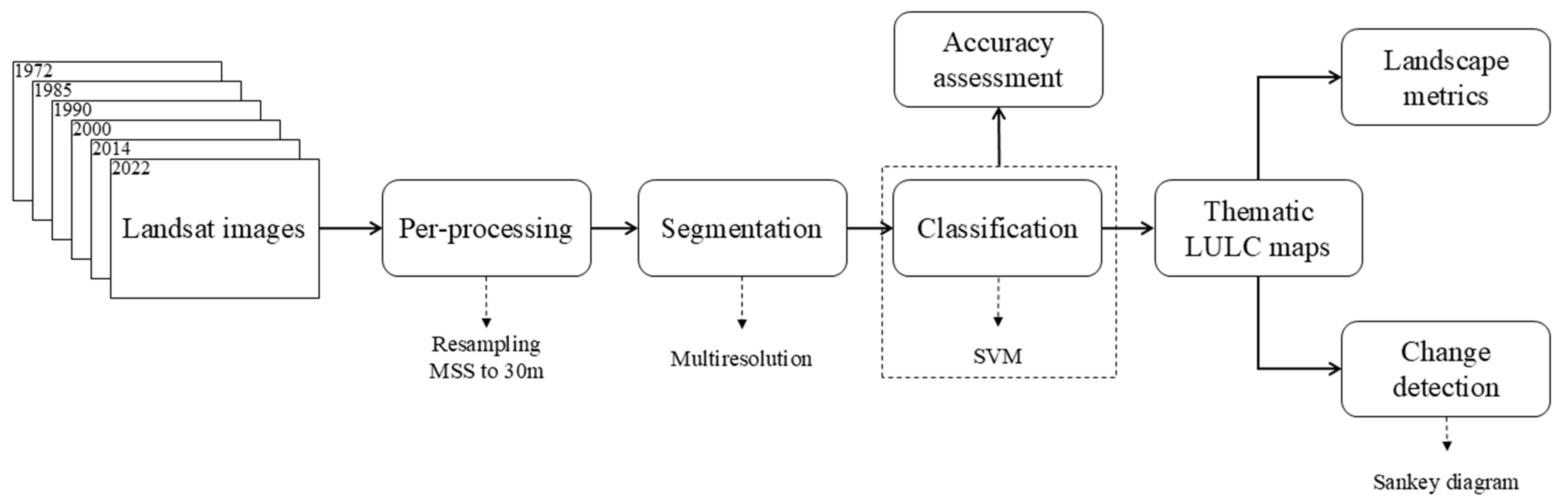
3. Materials and Methods
3.1. Data and Pre-Processing
3.2. Segmentation and Classification
3.3. Accuracy Assessment Analysis
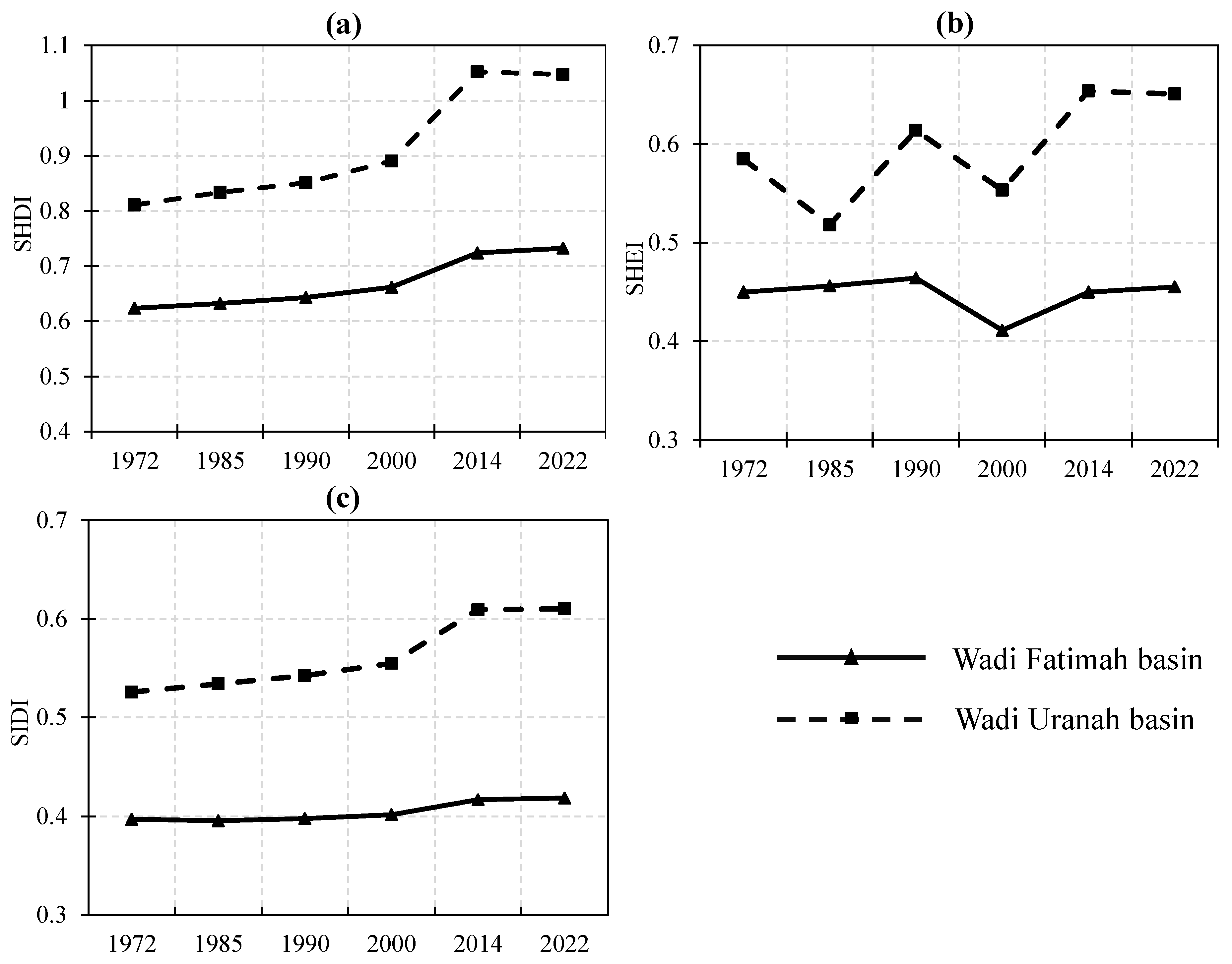
3.4. Landscape Metrics
4. Results
4.1. Accuracy Assessment
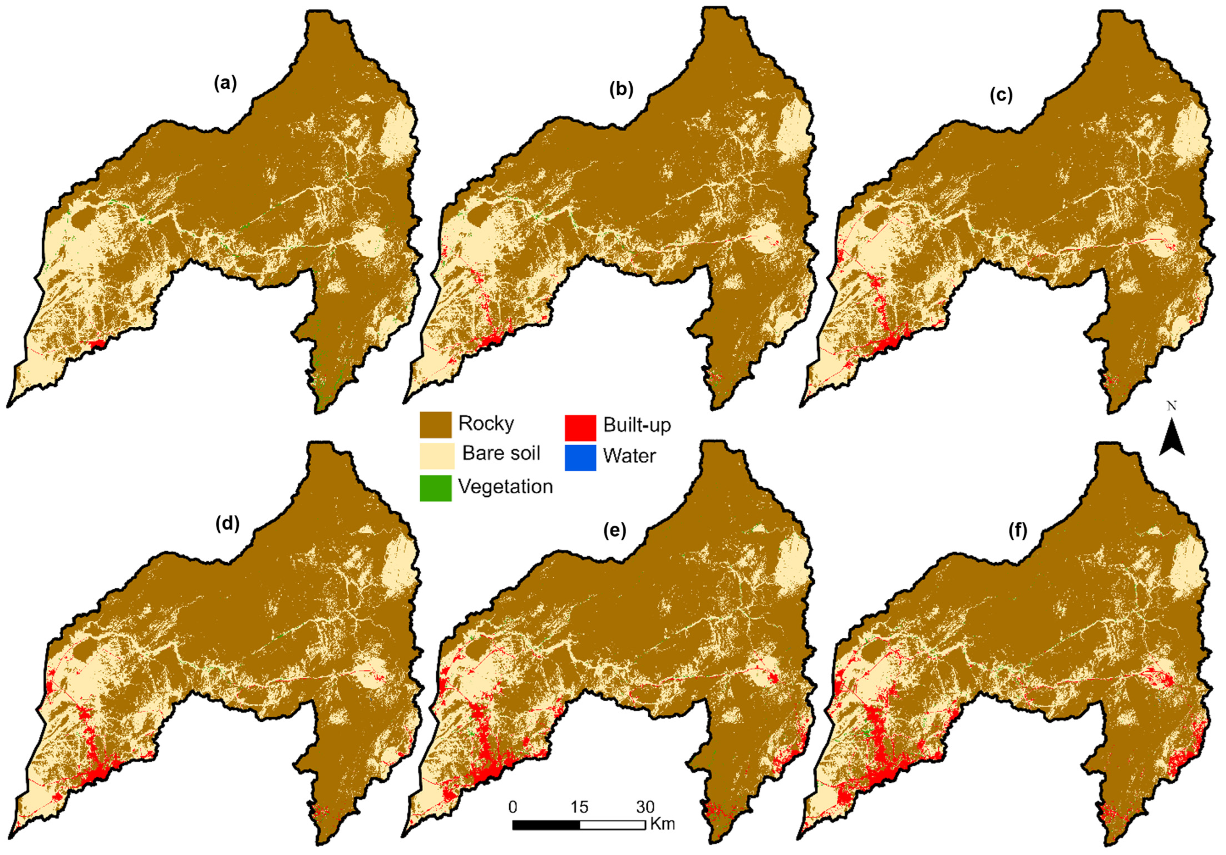
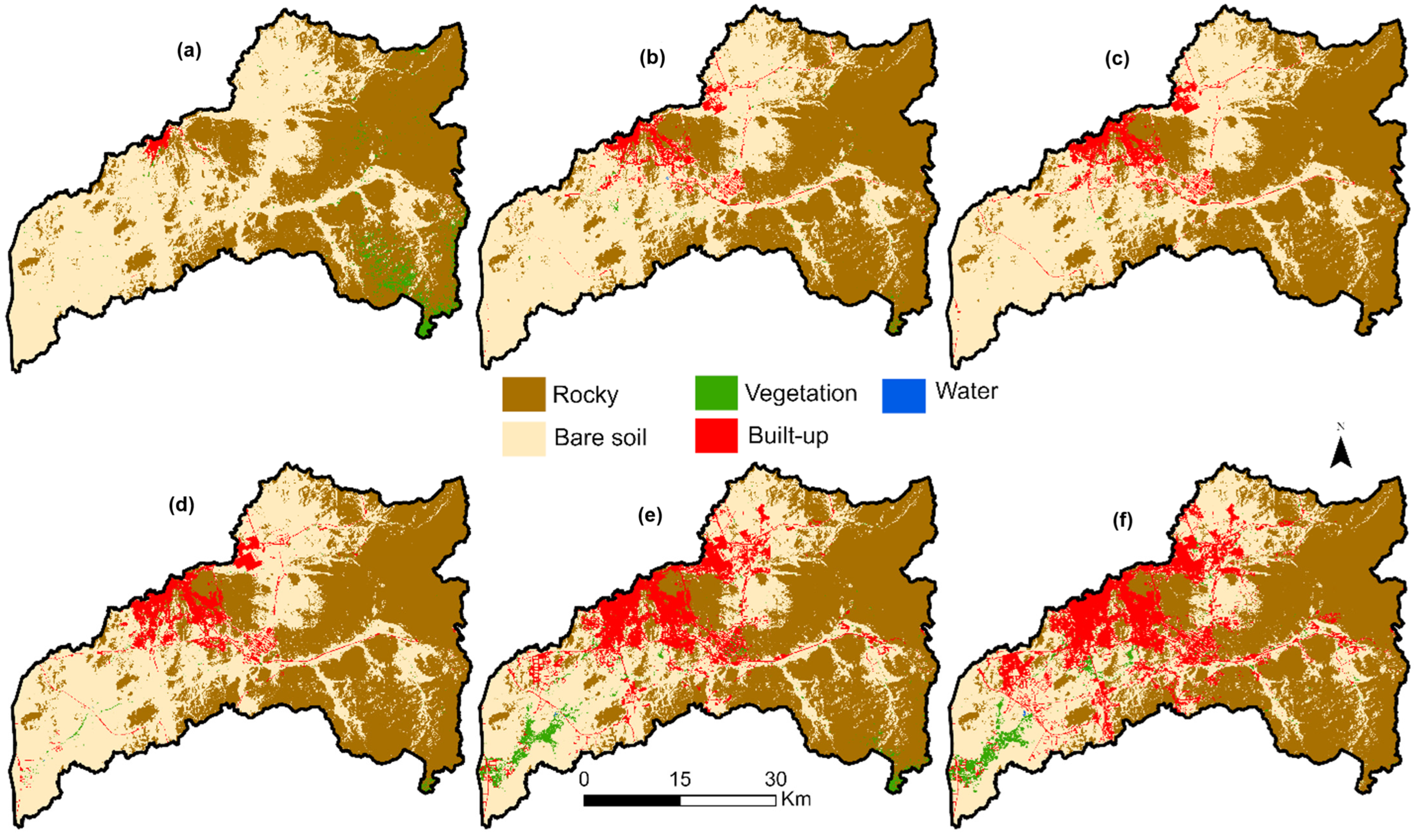
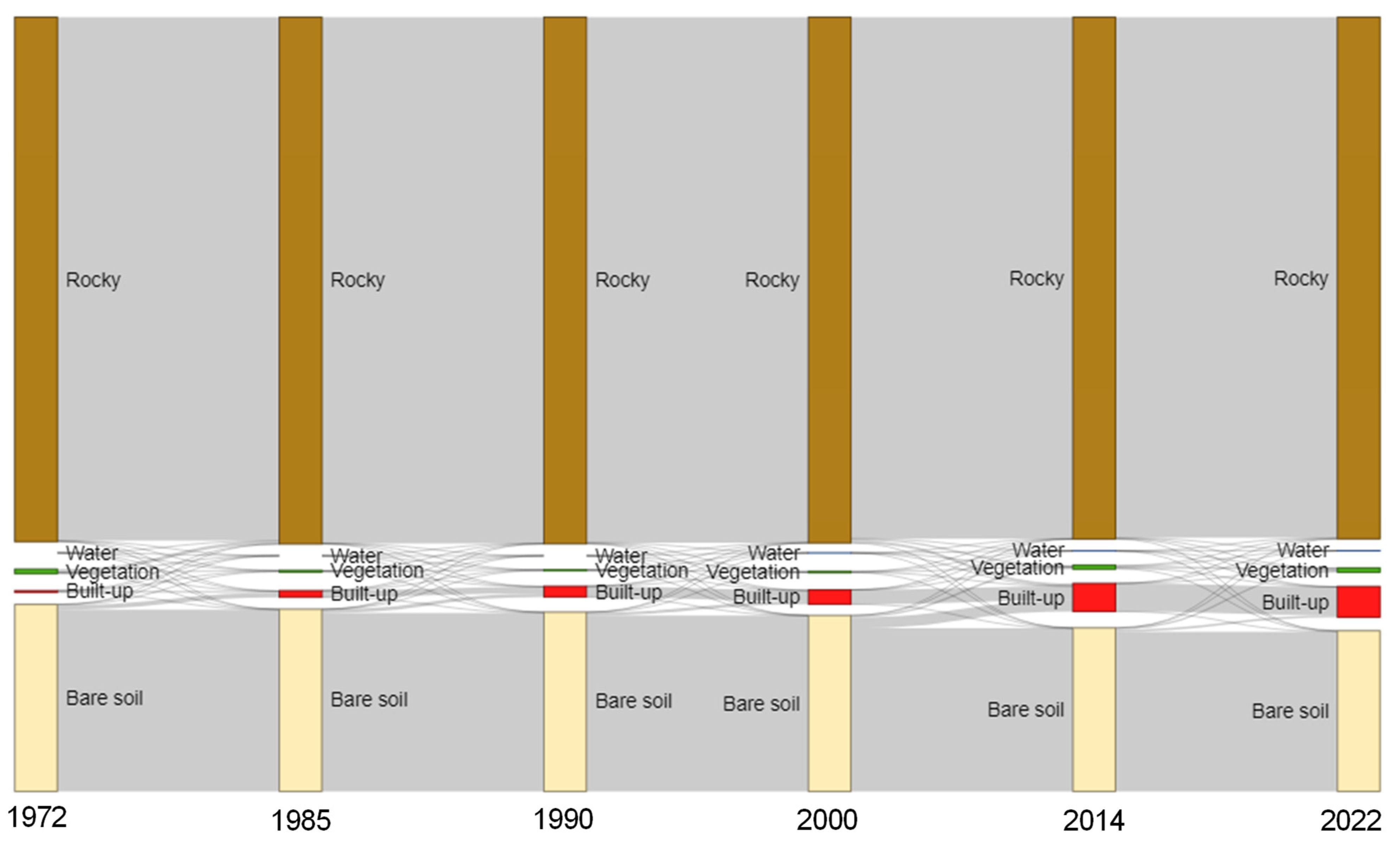
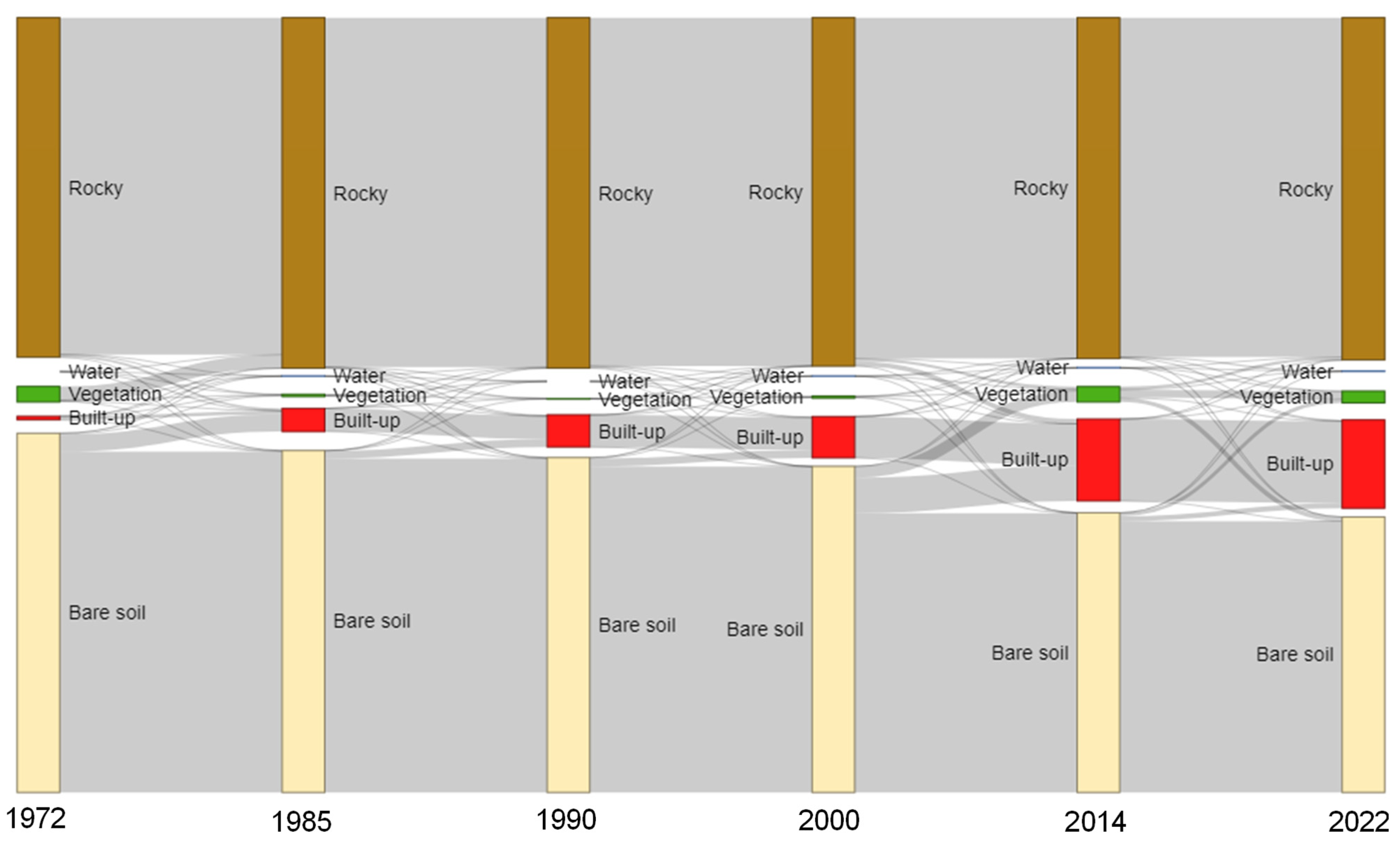
4.2. LULC Changes (1972–2022)
4.3. LULC Change Patterns (1972–2022)
4.4. Change Detection
5. Discussion
5.1. Urban Expansion (1972–2022)
5.2. LULC Patterns
5.3. LULC Changes Implications
5.4. Ecological Planning Implementations
5.5. Image Classification and Validation
5.6. Advantages and Limitations
6. Conclusions
Author Contributions
Funding
Data Availability Statement
Conflicts of Interest
References
- Gounaridis, D.; Chorianopoulos, I.; Symeonakis, E.; Koukoulas, S. A Random Forest-Cellular Automata modelling approach to explore future land use/cover change in Attica (Greece), under different socio-economic realities and scales. Sci. Total Environ. 2019, 646, 320–335. [Google Scholar] [CrossRef] [PubMed]
- Zeng, L.; Yang, L.; Su, L.; Hu, H.; Feng, C. The impact of policies on land use and land cover changes in the Beijing–Tianjin–Hebei region in China. Environ. Impact Assess. Rev. 2025, 110, 107676. [Google Scholar] [CrossRef]
- Keck, F.; Peller, T.; Alther, R.; Barouillet, C.; Blackman, R.; Capo, E.; Chonova, T.; Couton, M.; Fehlinger, L.; Kirschner, D.; et al. The global human impact on biodiversity. Nature 2025, 641, 395–400. [Google Scholar] [CrossRef]
- Guan, D.; Li, H.; Inohae, T.; Su, W.; Nagaie, T.; Hokao, K. Modeling urban land use change by the integration of cellular automaton and Markov model. Ecol. Model. 2011, 222, 3761–3772. [Google Scholar] [CrossRef]
- Lohwasser, J.; Bolognesi, T.; Schaffer, A. Impacts of population, affluence and urbanization on local air pollution and land transformation—A regional STIRPAT analysis for German districts. Ecol. Econ. 2025, 227, 108416. [Google Scholar] [CrossRef]
- Kamwi, J.M.; Cho, M.A.; Kaetsch, C.; Manda, S.O.; Graz, F.P.; Chirwa, P.W. Assessing the spatial drivers of land use and land cover change in the protected and communal areas of the Zambezi Region, Namibia. Land 2018, 7, 131. [Google Scholar] [CrossRef]
- Xu, G.; Chen, B. Generating a series of land covers by assimilating the existing land cover maps. ISPRS J. Photogramm. Remote Sens. 2019, 147, 206–214. [Google Scholar] [CrossRef]
- Gómez, C.; White, J.C.; Wulder, M.A. Optical remotely sensed time series data for land cover classification: A review. ISPRS J. Photogramm. Remote Sens. 2016, 116, 55–72. [Google Scholar] [CrossRef]
- Li, Y.; Chen, J.; Rao, Y. A practical sampling method for assessing accuracy of detected land cover/land use change: Theoretical analysis and simulation experiments. ISPRS J. Photogramm. Remote Sens. 2018, 144, 379–389. [Google Scholar] [CrossRef]
- Zhang, C.; Sargent, I.; Pan, X.; Li, H.; Gardiner, A.; Hare, J.; Atkinson, P.M. Joint Deep Learning for land cover and land use classification. Remote Sens. Environ. 2019, 221, 173–187. [Google Scholar] [CrossRef]
- Denize, J.; Hubert-Moy, L.; Betbeder, J.; Corgne, S.; Baudry, J.; Pottier, E. Evaluation of using sentinel-1 and-2 time-series to identify winter land use in agricultural landscapes. Remote Sens. 2018, 11, 37. [Google Scholar] [CrossRef]
- Shih, H.; Stow, D.A.; Tsai, Y.H. Guidance on and comparison of machine learning classifiers for Landsat-based land cover and land use mapping. Int. J. Remote Sens. 2019, 40, 1248–1274. [Google Scholar] [CrossRef]
- Alqurashi, A.F.; Kumar, L.; Sinha, P. Urban Land Cover Change Modelling Using Time-Series Satellite Images: A Case Study of Urban Growth in Five Cities of Saudi Arabia. Remote Sens. 2016, 8, 838. [Google Scholar] [CrossRef]
- Ye, Z.; Yang, K.; Lin, Y.; Guo, S.; Sun, Y.; Chen, X.; Lai, R.; Zhang, H. A comparison between Pixel-based deep learning and Object-based image analysis (OBIA) for individual detection of cabbage plants based on UAV Visible-light images. Comput. Electron. Agric. 2023, 209, 107822. [Google Scholar] [CrossRef]
- Bayazit, M.; Dönmez, C.; Berberoglu, S. Assessing the efficiency of pixel-based and object-based image classification using deep learning in an agricultural Mediterranean plain. Environ. Monit. Assess. 2025, 197, 155. [Google Scholar] [CrossRef]
- Šímová, P.; Gdulová, K. Landscape indices behavior: A review of scale effects. Appl. Geogr. 2012, 34, 385–394. [Google Scholar] [CrossRef]
- Zylshal; Sulma, S.; Yulianto, F.; Nugroho, J.; Sofan, P. A support vector machine object based image analysis approach on urban green space extraction using Pleiades-1A imagery. Model. Earth Syst. Environ. 2016, 2, 54. [Google Scholar] [CrossRef]
- Tzotsos, A.; Argialas, D. Support vector machine classification for object-based image analysis. In Object-Based Image Analysis; Springer: Berlin/Heidelberg, Germany, 2008; pp. 663–677. [Google Scholar]
- Liu, H.; Weng, Q. Landscape metrics for analysing urbanization-induced land use and land cover changes. Geocarto Int. 2013, 28, 582–593. [Google Scholar] [CrossRef]
- Liu, T.; Yang, X. Monitoring land changes in an urban area using satellite imagery, GIS and landscape metrics. Appl. Geogr. 2015, 56, 42–54. [Google Scholar] [CrossRef]
- O’Neill, R.V.; Krummel, J.R.; Gardner, R.H.; Sugihara, G.; Jackson, B.; DeAngelis, D.L.; Milne, B.T.; Turner, M.G.; Zygmunt, B.; Christensen, S.W.; et al. Indices of landscape pattern. Landsc. Ecol. 1988, 1, 153–162. [Google Scholar] [CrossRef]
- McGarigal, K.; Romme, W.H.; Crist, M.; Roworth, E. Cumulative effects of roads and logging on landscape structure in the San Juan Mountains, Colorado (USA). Landsc. Ecol. 2001, 16, 327–349. [Google Scholar] [CrossRef]
- McGarigal, K.; Marks, B.J. Spatial Pattern Analysis Program for Quantifying Landscape Structure; General Technical Report PNW-GTR-351; US Department of Agriculture, Forest Service, Pacific Northwest Research Station: Portland, OR, USA, 1995; pp. 1–122. [Google Scholar]
- Sinha, P.; Kumar, L.; Reid, N. Rank-based methods for selection of landscape metrics for land cover pattern change detection. Remote Sens. 2016, 8, 107. [Google Scholar] [CrossRef]
- Vincent, P. Saudi Arabia: An Environmental Overview; CRC Press: Boca Raton, FL, USA, 2008. [Google Scholar]
- Alqurashi, A.F.; Kumar, L. Land Use and Land Cover Change Detection in the Saudi Arabian Desert Cities of Makkah and Al-Taif Using Satellite Data. Adv. Remote Sens. 2014, 3, 106–119. [Google Scholar] [CrossRef]
- Rahman, M.T.; Aldosary, A.S.; Mortoja, M.G. Modeling Future Land Cover Changes and Their Effects on the Land Surface Temperatures in the Saudi Arabian Eastern Coastal City of Dammam. Land 2017, 6, 36. [Google Scholar] [CrossRef]
- Alqurashi, A.F.; Kumar, L. Spatiotemporal patterns of urban change and associated environmental impacts in five Saudi Arabian cities: A case study using remote sensing data. Habitat Int. 2016, 58, 75–88. [Google Scholar] [CrossRef]
- Anisurrahman, M.; Alshuwaikhat, H.M. Determining Sustainability Assessment Indicators for the Holy City of Makkah, Saudi Arabia. Arab. J. Sci. Eng. 2019, 44, 5165–5178. [Google Scholar] [CrossRef]
- Ascoura, I.E. Impact of pilgrimage (Hajj) on the urban growth of the Mecca. J. Educ. Soc. Res. 2013, 3, 255–263. [Google Scholar] [CrossRef]
- Alqurashi, A.F.; Kumar, L. An assessment of the impact of urbanization and land use changes in the fast-growing cities of Saudi Arabia. Geocarto Int. 2017, 34, 78–97. [Google Scholar] [CrossRef]
- Jelil Niang, A.; Hermas, E.; Alharbi, O.; Al-Shaery, A. Monitoring landscape changes and spatial urban expansion using multi-source remote sensing imagery in Al-Aziziyah Valley, Makkah, KSA. Egypt. J. Remote Sens. Space Sci. 2020, 23, 89–96. [Google Scholar] [CrossRef]
- Alqurashi, A.F. Quantification of Urban Patterns and Processes through Space and Time Using Remote Sensing Data: A Comparative Study between Three Saudi Arabian Cities. Sustainability 2021, 13, 12615. [Google Scholar] [CrossRef]
- Subyani, A.M. Hydrologic behavior and flood probability for selected arid basins in Makkah area, western Saudi Arabia. Arab. J. Geosci. 2011, 4, 817–824. [Google Scholar] [CrossRef]
- Al-Hathloul, S.; Mughal, M.A. Urban growth management-the Saudi experience. Habitat Int. 2004, 28, 609–623. [Google Scholar] [CrossRef]
- Alqurashi, A.F.; Kumar, L.; Al-Ghamdi, K.A. Spatiotemporal Modeling of Urban Growth Predictions Based on Driving Force Factors in Five Saudi Arabian Cities. ISPRS Int. J. Geo-Inf. 2016, 5, 139. [Google Scholar] [CrossRef]
- Appiah-Twum, M.; Xu, W.; Sunkari, E. Mapping Lithology with Hybrid Attention Mechanism–Long Short-Term Memory: A Hybrid Neural Network Approach Using Remote Sensing and Geophysical Data. Remote Sens. 2024, 16, 4613. [Google Scholar] [CrossRef]
- Benz, U.C.; Hofmann, P.; Willhauck, G.; Lingenfelder, I.; Heynen, M. Multi-resolution, object-oriented fuzzy analysis of remote sensing data for GIS-ready information. ISPRS J. Photogramm. Remote Sens. 2004, 58, 239–258. [Google Scholar] [CrossRef]
- Drǎguţ, L.; Tiede, D.; Levick, S.R. ESP: A tool to estimate scale parameter for multiresolution image segmentation of remotely sensed data. Int. J. Geogr. Inf. Sci. 2010, 24, 859–871. [Google Scholar] [CrossRef]
- Li, Q.; Wang, C.; Zhang, B.; Lu, L. Object-based crop classification with Landsat-MODIS enhanced time-series data. Remote Sens. 2015, 7, 16091–16107. [Google Scholar] [CrossRef]
- Gleason, C.J.; Im, J. Forest biomass estimation from airborne LiDAR data using machine learning approaches. Remote Sens. Environ. 2012, 125, 80–91. [Google Scholar] [CrossRef]
- Xu, L.; Li, J.; Brenning, A. A comparative study of different classification techniques for marine oil spill identification using RADARSAT-1 imagery. Remote Sens. Environ. 2014, 141, 14–23. [Google Scholar] [CrossRef]
- Thanh Noi, P.; Kappas, M. Comparison of random forest, k-nearest neighbor, and support vector machine classifiers for land cover classification using Sentinel-2 imagery. Sensors 2017, 18, 18. [Google Scholar] [CrossRef]
- Mountrakis, G.; Im, J.; Ogole, C. Support vector machines in remote sensing: A review. ISPRS J. Photogramm. Remote Sens. 2011, 66, 247–259. [Google Scholar] [CrossRef]
- Ishida, H.; Oishi, Y.; Morita, K.; Moriwaki, K.; Nakajima, T.Y. Development of a support vector machine based cloud detection method for MODIS with the adjustability to various conditions. Remote Sens. Environ. 2018, 205, 390–407. [Google Scholar] [CrossRef]
- Jung, M. LecoS-A QGIS Plugin for Automated Landscape Ecology Analysis. PeerJ Prepr. 2013, 1, e116v2. [Google Scholar]
- Sertel, E.; Topaloğlu, R.H.; Şallı, B.; Yay Algan, I.; Aksu, G.A. Comparison of Landscape Metrics for Three Different Level Land Cover/Land Use Maps. ISPRS Int. J. Geo-Inf. 2018, 7, 408. [Google Scholar] [CrossRef]
- Seto, K.C.; Fragkias, M. Quantifying Spatiotemporal Patterns of Urban Land-use Change in Four Cities of China with Time Series Landscape Metrics. Landsc. Ecol. 2005, 20, 871–888. [Google Scholar] [CrossRef]
- Dietzel, C.; Herold, M.; Hemphill, J.J.; Clarke, K.C. Spatio-temporal dynamics in California’s Central Valley: Empirical links to urban theory. Int. J. Geogr. Inf. Sci. 2005, 19, 175–195. [Google Scholar] [CrossRef]
- Nolasco, M.; Balzarini, M. Assessment of temporal aggregation of Sentinel-2 images on seasonal land cover mapping and its impact on landscape metrics. Environ. Monit. Assess. 2025, 197, 142. [Google Scholar] [CrossRef]
- McGarigal, K.; Cushman, S.A.; Neel, M.; Ene, E. FRAGSTATS: Spatial Pattern Analysis Program for Categorical Maps. Computer Software Program Produced by the Authors at the University of Massachusetts, Amherst. 2002. Available online: https://www.fragstats.org (accessed on 13 November 2024).
- Zhao, Y.; Tomita, M.; Hara, K.; Fujihara, M.; Yang, Y.; Da, L. Effects of topography on status and changes in land-cover patterns, Chongqing City, China. Landsc. Ecol. Eng. 2014, 10, 125–135. [Google Scholar] [CrossRef]
- Li, X.; Zhou, W.; Ouyang, Z. Forty years of urban expansion in Beijing: What is the relative importance of physical, socioeconomic, and neighborhood factors? Appl. Geogr. 2013, 38, 1–10. [Google Scholar] [CrossRef]
- Bindajam, A.A.; Mallick, J. Impact of the Spatial Configuration of Streets Networks on Urban Growth: A Case Study of Abha City, Saudi Arabia. Sustainability 2020, 12, 1856. [Google Scholar] [CrossRef]
- Al-Huqail, A.A.; Al-Harbi, H.F.; Alowaifeer, A.M.; El-Sheikh, M.A.; Assaeed, A.M.; Alsaleem, T.S.; Kassem, H.S.; Azab, O.M.; Dar, B.A.; Malik, J.A.; et al. Correlation between aboveground vegetation composition and soil seed bank of Raudhat desert habitat: A case study of Raudhat Alkhafs, Saudi Arabia. BMC Plant Biol. 2025, 25, 136. [Google Scholar] [CrossRef]
- Liu, W.; Wu, J.; Xu, F.; Mu, D.; Zhang, P. Modeling the effects of land use/land cover changes on river runoff using SWAT models: A case study of the Danjiang River source area, China. Environ. Res. 2024, 242, 117810. [Google Scholar] [CrossRef]
- Banjara, M.; Bhusal, A.; Ghimire, A.B.; Kalra, A. Impact of Land Use and Land Cover Change on Hydrological Processes in Urban Watersheds: Analysis and Forecasting for Flood Risk Management. Geosciences 2024, 14, 40. [Google Scholar] [CrossRef]
- Wang, N.; Chen, X.; Zhang, Y.; Pang, J.; Long, Z.; Chen, Y.; Zhang, Z. Integrated effects of land use and land cover change on carbon metabolism: Based on ecological network analysis. Environ. Impact Assess. Rev. 2024, 104, 107320. [Google Scholar] [CrossRef]
- Hussain, S.; Karuppannan, S. Land use/land cover changes and their impact on land surface temperature using remote sensing technique in district Khanewal, Punjab Pakistan. Geol. Ecol. Landsc. 2023, 7, 46–58. [Google Scholar] [CrossRef]
- Pande, C.B.; Diwate, P.; Orimoloye, I.R.; Sidek, L.M.; Pratap, M.A.; Moharir, K.N.; Pal, S.C.; Alshehri, F.; Tolche, A.D. Impact of land use/land cover changes on evapotranspiration and model accuracy using Google Earth engine and classification and regression tree modeling. Geomat. Nat. Hazards Risk 2024, 15, 2290350. [Google Scholar] [CrossRef]
- Ahmadi, H.; Popalzai, A.; Bekbotayeva, A.; Omarova, G.; Assubayeva, S.; Arshamov, Y.; Pekkan, E. Assessing the Impacts of Landuse-Landcover (LULC) Dynamics on Groundwater Depletion in Kabul, Afghanistan’s Capital (2000–2022): A Geospatial Technology-Driven Investigation. Geosciences 2024, 14, 132. [Google Scholar] [CrossRef]
- Soltani, A.; Azizi, P.; Javadpoor, M.; Allan, A.; Bagheri, B. Determining and Quantifying Urban Sprawl Drivers: A Delphi-DANP Approach. Land 2025, 14, 311. [Google Scholar] [CrossRef]
- Green, R.E.; Cornell, S.J.; Scharlemann, J.P.W.; Balmford, A. Farming and the Fate of Wild Nature. Science 2005, 307, 550–555. [Google Scholar] [CrossRef] [PubMed]
- Fischer, J.; Abson, D.J.; Butsic, V.; Chappell, M.J.; Ekroos, J.; Hanspach, J.; Kuemmerle, T.; Smith, H.G.; von Wehrden, H. Land Sparing Versus Land Sharing: Moving Forward. Conserv. Lett. 2014, 7, 149–157. [Google Scholar] [CrossRef]
- Soga, M.; Yamaura, Y.; Koike, S.; Gaston, K.J. Land sharing vs. land sparing: Does the compact city reconcile urban development and biodiversity conservation? J. Appl. Ecol. 2014, 51, 1378–1386. [Google Scholar] [CrossRef]
- Ibáñez-Álamo, J.D.; Morelli, F.; Benedetti, Y.; Rubio, E.; Jokimäki, J.; Pérez-Contreras, T.; Sprau, P.; Suhonen, J.; Tryjanowski, P.; Kaisanlahti-Jokimäki, M.; et al. Biodiversity within the city: Effects of land sharing and land sparing urban development on avian diversity. Sci. Total Environ. 2020, 707, 135477. [Google Scholar] [CrossRef]
- Chandra, M.A.; Bedi, S.S. Survey on SVM and their application in imageclassification. Int. J. Inf. Technol. 2021, 13, 1–11. [Google Scholar] [CrossRef]
- Dabija, A.; Kluczek, M.; Zagajewski, B.; Raczko, E.; Kycko, M.; Al-Sulttani, A.H.; Tardà, A.; Pineda, L.; Corbera, J. Comparison of Support Vector Machines and Random Forests for Corine Land Cover Mapping. Remote Sens. 2021, 13, 777. [Google Scholar] [CrossRef]
- Xie, G.; Niculescu, S. Mapping and Monitoring of Land Cover/Land Use (LCLU) Changes in the Crozon Peninsula (Brittany, France) from 2007 to 2018 by Machine Learning Algorithms (Support Vector Machine, Random Forest, and Convolutional Neural Network) and by Post-classification Comparison (PCC). Remote Sens. 2021, 13, 3899. [Google Scholar]
- Congalton, R.G.; Green, K. Assessing the Accuracy of Remotely Sensed Data: Principles and Practices, 3rd ed.; CRC Press: Boca Raton, FL, USA, 2019. [Google Scholar]
- Zhao, Y.; Gong, P.; Yu, L.; Hu, L.; Li, X.; Li, C.; Zhang, H.; Zheng, Y.; Wang, J.; Zhao, Y.; et al. Towards a common validation sample set for global land-cover mapping. Int. J. Remote Sens. 2014, 35, 4795–4814. [Google Scholar] [CrossRef]
- Li, C.; Wang, J.; Wang, L.; Hu, L.; Gong, P. Comparison of Classification Algorithms and Training Sample Sizes in Urban Land Classification with Landsat Thematic Mapper Imagery. Remote Sens. 2014, 6, 964–983. [Google Scholar] [CrossRef]


| No. | Sensor | Path/Row | Date | Grid Cell Size (m) | No. of Bands 1 |
|---|---|---|---|---|---|
| 1 | MSS | 182/45 | 10 September 1972 | 60 | 4 |
| 2 | TM | 169/45 | 30 March 1985 | 30 | 6 |
| 3 | TM | 169/45 | 27 August 1990 | 30 | 6 |
| 4 | ETM+ | 169/45 | 6 August 2000 | 30 | 6 |
| 5 | OLI | 169/45 | 5 August 2014 | 30 | 7 |
| 6 | OLI | 169/45 | 15 July 2022 | 30 | 7 |
| Name and Level | Type | Equation | Description * |
|---|---|---|---|
| Number of patches (NP) (class) | Area | Quantifies the NPs for each individual class | |
| Patch density (PD) (class) | Aggregation | A is the total area (m2) | Describes the landscape fragmentation |
| Landscape proportion (LP) (class) | Area | is the class area | Represents the class size of the total land cover classes (cells) |
| Class area (CA) (class) | Area | Measures the landscape composition of a particular patch type | |
| Largest patch index (LPI) (class) | Area | is the area of the patch | Quantifies the percentage of total landscape area comprised by the largest patch |
| Shannon’s diversity index (SHDI; landscape) | Heterogeneity | is the class proportion | Based on information theory and representing the amount of information per patch |
| Shannon’s evenness index (SHEI; landscape) | Heterogeneity | m is the number of classes | Measures the distribution of area among patch types |
| Simpson’s diversity index (SIDI; landscape) | Heterogeneity | The probability that any two patches drawn at random will represent different patch types |
| Wadi Fatimah basin | ||||||||||||
| 1972 | 1985 | 1990 | 2000 | 2014 | 2022 | |||||||
| Class | PA | UA | PA | UA | PA | UA | PA | UA | PA | UA | PA | UA |
| Rocky | 96.4 | 98 | 96.9 | 99.7 | 98.5 | 99.2 | 96.4 | 99.5 | 98 | 99.6 | 100 | 100 |
| Bare soil | 93.5 | 88.9 | 99.1 | 89.9 | 96.7 | 95.2 | 97.7 | 88.3 | 98.4 | 93.3 | 100 | 95 |
| Vegetation | 100 | 100 | 100 | 100 | 100 | 100 | 100 | 100 | 100 | 100 | 100 | 100 |
| Built-up | 100 | 100 | 93.3 | 100 | 100 | 95.2 | 83.3 | 96.1 | 100 | 100 | 100 | 100 |
| Water | 0 | 0 | 0 | 0 | 0 | 0 | 100 | 62.5 | 100 | 100 | 100 | 100 |
| OA | 95.8 | 97.3 | 98.1 | 96.1 | 98.2 | 98.7 | ||||||
| Kappa | 0.89 | 0.94 | 0.95 | 0.91 | 0.95 | 0.97 | ||||||
| Wadi Uranah basin | ||||||||||||
| 1972 | 1985 | 1990 | 2000 | 2014 | 2022 | |||||||
| Class | PA | UA | PA | UA | PA | UA | PA | UA | PA | UA | PA | UA |
| Rocky | 100 | 93.5 | 98.2 | 98.2 | 95.7 | 98.5 | 94.5 | 93.8 | 93.3 | 93.3 | 95.1 | 94.1 |
| Bare soil | 94.7 | 98.9 | 99.1 | 94.1 | 98.5 | 96.3 | 93 | 92.3 | 90.5 | 82.5 | 93.2 | 95 |
| Vegetation | 100 | 100 | 100 | 100 | 100 | 100 | 80 | 80 | 100 | 100 | 94.1 | 100 |
| Built-up | 87.5 | 100 | 95 | 100 | 100 | 39.3 | 100 | 95.4 | 96.6 | 91.8 | 97 | 95.5 |
| Water | 0 | 0 | 72.2 | 100 | 0 | 0 | 66.7 | 100 | 100 | 100 | 100 | 93.3 |
| OA | 96.7 | 96.6 | 97.2 | 93.2 | 93.05 | 94.8 | ||||||
| Kappa | 0.94 | 0.95 | 0.95 | 0.89 | 0.89 | 0.92 | ||||||
| Wadi Fatimah basin | ||||||
| Class | 1972 | 1985 | 1990 | 2000 | 2014 | 2022 |
| Bare soil | 108,025.38 | 105,259.95 | 103,562.91 | 101,680.29 | 94,440.42 | 91,405.71 |
| Rocky | 303,099.02 | 302,481.06 | 302,385.12 | 304,877.25 | 302,565.15 | 302,085.23 |
| Built-up | 881.73 | 3865.77 | 6163.65 | 8272.17 | 16,245.27 | 21,111.03 |
| Vegetation | 2607.57 | 1006.92 | 502.11 | 777.96 | 2362.05 | 2397.06 |
| Water | 0 | 0 | 0 | 6.21 | 1.35 | 14.22 |
| Wadi Uranah basin | ||||||
| Class | 1972 | 1985 | 1990 | 2000 | 2014 | 2022 |
| Bare soil | 108,523.44 | 103,290.57 | 101,169.36 | 98,544.42 | 84,494.25 | 77,826.96 |
| Rocky | 106,691.8 | 106,007.67 | 105,953.22 | 105,375.06 | 103,081.14 | 101,846.79 |
| Built-up | 1104.03 | 7014.15 | 9737.82 | 12,503.52 | 24,775.56 | 33,131.25 |
| Vegetation | 4718.61 | 712.98 | 177.48 | 612.54 | 4669.2 | 4165.83 |
| Water | 0 | 12.51 | 0 | 2.52 | 18 | 30.6 |
Disclaimer/Publisher’s Note: The statements, opinions and data contained in all publications are solely those of the individual author(s) and contributor(s) and not of MDPI and/or the editor(s). MDPI and/or the editor(s) disclaim responsibility for any injury to people or property resulting from any ideas, methods, instructions or products referred to in the content. |
© 2025 by the authors. Licensee MDPI, Basel, Switzerland. This article is an open access article distributed under the terms and conditions of the Creative Commons Attribution (CC BY) license (https://creativecommons.org/licenses/by/4.0/).
Share and Cite
Alqurashi, A.F.; Alharbi, O.A. Changes in Land Use and Land Cover Patterns in Two Desert Basins Using Remote Sensing Data. Geosciences 2025, 15, 178. https://doi.org/10.3390/geosciences15050178
Alqurashi AF, Alharbi OA. Changes in Land Use and Land Cover Patterns in Two Desert Basins Using Remote Sensing Data. Geosciences. 2025; 15(5):178. https://doi.org/10.3390/geosciences15050178
Chicago/Turabian StyleAlqurashi, Abdullah F., and Omar A. Alharbi. 2025. "Changes in Land Use and Land Cover Patterns in Two Desert Basins Using Remote Sensing Data" Geosciences 15, no. 5: 178. https://doi.org/10.3390/geosciences15050178
APA StyleAlqurashi, A. F., & Alharbi, O. A. (2025). Changes in Land Use and Land Cover Patterns in Two Desert Basins Using Remote Sensing Data. Geosciences, 15(5), 178. https://doi.org/10.3390/geosciences15050178