Abstract
Fossil plant localities are potential geosites, but related information is limited for some paleofloristic domains. Four geosites representing Visean (Mississippian, Carboniferous) plant-bearing deposits are reported from two areas of the Moscow Basin (central eastern Laurussia). These are the Mountainous Msta area in the northwestern segment of this basin and the Tula Region in its southern segment. The localities were examined in the field and characterized with criteria related to geoheritage properties (e.g., geoheritage types, physical view, accessibility, vulnerability, and research importance). One of these localities has already been established as a geosite (official status of protected area) and three other localities are proposed as geosites in this work (two of them are situated in the planned protected area). It is established that all considered geosites represent notable assemblages of Visean plants, with some exhibiting unique preservation and interesting sedimentary features, such as the “Tula pipes”. Essentially, the localities are small natural outcrops and abandoned quarries with perfect accessibility. They have potential for future research projects, as well as for geological education and tourism. Presently, their vulnerability is only potential, but it can increase due to touristic exploitation in the nearest future; thus, this property requires special attention. More generally, these geosites are important sources of the knowledge of the Early Carboniferous equatorial vegetation in eastern Laurussia.
1. Introduction
Fossil plant localities have been proposed as geosites in many regions [1,2,3,4,5,6,7]. Many of them are linked to Carboniferous deposits [8,9,10,11,12]. Particularly, the Visean Stage lasted 16.4 Ma (from 346.7 Ma to 330.3 Ma) [13,14], and it was characterized by a rather high diversity of plants [15] and their long-distance dispersal [16]. Some Visean plant localities are known internationally [17]. However, the knowledge of geosites representing Visean floras remains restricted in some paleofloristic domains.
The Moscow Basin (also known as the Moscow Coal Basin) is a large structure in the central part of the Russian Platform [18,19]. The latter is a core of Baltica, which was a large terrane or small lithospheric plate [20,21] and then part of Laurussia and Pangea [22,23]. Now, this is a part of Eurasia [24]. Carboniferous deposits are widely distributed in the Moscow Basin [25,26,27], particularly Visean strata with abundant fossil plant crops [28,29]. Indeed, some localities of Visean plants can be considered as geosites. The reexamination of the earlier established geosites and the proposal of some new geosites can enhance geoheritage research in the Moscow Basin, which has already been started [30,31].
The objective of the present work is to report several geosites related to Visean fossil plant localities of the Moscow Basin. Field work carried out in this basin permitted us to characterize four notable localities in two areas. Importantly, this study focuses on geoheritage features, and it does not intend to report new paleobotanical material. This means that attention is paid to fossil plant localities as either already established geosites with official status or potential geosites needing proposals. Any comprehensive territorial inventory of geoheritage would be too ambitious of a task; thus, a thematic study of geosites was carried out.
2. Geological Setting
The territory considered in the present study corresponds to a central part of the Russian Platform, which is a Baltic core of Eurasia (Figure 1a) that stabilized in the Precambrian [24]. A huge tectonic structure of the Moscow Syneclise exists there and looks like a giant, rounded synclinal fold with very gentle limbs. Coal-bearing deposits of Carboniferous age crops are located in the western and southern peripheries of the syneclise, which are known as the Moscow Basin [32] (Figure 1b).
The regional stratigraphy of Carboniferous and particularly Visean deposits of the Moscow Basin was developed with paleontological information (particularly, miospores and foraminifers) [27,33,34,35,36,37]. In the northwestern segment of the basin, four formations of Visean age are dominated by mixed carbonate and siliciclastic packages (Figure 1c). The Visean succession of the southern segment includes a lower part dominated by siliciclastics (two formations) and an upper part dominated by carbonates (three formations) (Figure 1c). Alekseeva et al. [28], Makhlina [27], and Mosseichik and Ruban [29] characterized depositional environments. Accumulation took place on an alluvial plain (including delta and swamps) and in periodically ingressed seas. Lateral shoreline shifts were frequent and spanned a long distance.
This study deals with the Mountainous Msta area and the Tula Region; these areas represent the northwestern and southern segments of the Moscow Basin, respectively (Figure 1b). The Mountainous Msta area is located near Borovichi town, and it has remained one of the classical Russian areas for Carboniferous studies for about a century [38]. The second area is located near Tula city in the center of the Tula Region, where the local geoheritage potential has already been revealed [31]. Visean deposits of these areas are typical to the related segments of the Moscow Basin (Figure 1c).

Figure 1.
General location of the considered territory (a) and the study areas (b) and correlation of the composite stratigraphical columns of the considered segments (c). Limits of the Moscow Syneclise after Makhlina et al. [33], limits of the Moscow Basin after Yablokov [32], chronostratigraphy and unit colors after Gradstein et al. [13], and regional stratigraphy after Osipova et al. [35], updated by [35,36,37].
3. Materials and Methods
Two important fossil plant localities are considered for each of the study areas, i.e., Putlino and Yogla in the Mountainous Msta area (Figure 2a,b) and Georgievo and Schyokino in the Tula Region (Figure 2c,d). These localities exhibit Visean deposits with multiple plant remains and some other notable features (see descriptions below). Field observations have provided insight, enabling us to characterize these localities regarding their geoheritage significance. Importantly, Georgievo has already received an official status, i.e., it is an established geosite [31]. Three other localities are proposed as geosites in this work, and two of them (Putlino and Yogla) are located within an officially planned protected area.
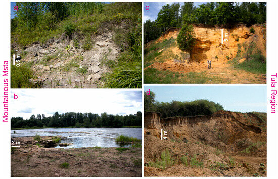
Figure 2.
General views of four considered geosites: (a)—Putlino, (b)—Yogla, (c)—Georgievo, and (d)—Schyokino.
Various approaches have been proposed to analyze geosites [39,40,41,42,43,44,45,46]. However, the successful application of these approaches depends on local conditions and particular research purposes. Moreover, the semi-quantitative assessment of geosites has often been preferred, although there are geosite properties (e.g., geometry or color) which cannot be quantified. The present study focuses on geosite descriptions; thus, all properties are important to consider for all localities (Table 1). Special attention is paid to the geological content of geosites, and their abridged geological descriptions and elementary paleobotanical information are provided. This study is not a pure paleobotanical work; thus, plant fossils are not described and illustrated only generally. Taxonomic descriptions and related illustrations can be found in the paleobotanical synthesis by Mosseichik [47].

Table 1.
Geosite properties considered in the present study (partly based on the previous lists of properties [39,41]).
The properties of geosites are established with standardized grades (sensu [41]), i.e., each property is expressed as a set of simple characteristics (Table 1). The collected information about each geosite permits attributing it to a particular grade of each property. For instance, if previous field works documented a locality stretching for several hundreds of meters along a river, this geosite is attributed to the linear grade of the geometry property. It should be stressed that the importance of each geosite is determined, first of all, by its geological (also paleontological) content and related interpretations, and the other properties are supplementary. For instance, landscape scenery influences touristic importance, but its absence cannot be an argument against a geosite proposal. Moreover, the need for a geosite proposal does not depend on the rarity of features, and geosites should not be only globally representative. For instance, any regionally rare feature has importance for a particular territory or geological domain, and the related geosite can be established.
The present study is fully analytical because it is based on the pre-established geosite properties and the related grades (Table 1). Each property of each considered geosite is checked, and the outcomes present a novel vision of all geosites. The related procedures make possible a comparison of the established and proposed geosites by the full set of their properties.
4. Results
4.1. Geological and Paleobotanical Features
4.1.1. Mountainous Msta
Putlino
This locality is situated southeast of Borovichi town (Figure 1b). Putlino village occupies a hill composed of thick Quaternary boulder-bearing silts, which overlay Carboniferous deposits. The latter crop out at the toes of this hill on the right bank of the Msta River (Figure 2a). These deposits are grey clays and yellow sands and sandstones with pyrite concretions (visible thickness is ~3 m) (Figure 3a). They belong to the Mstinskaya and Putlinskaya formations (undivided locally) of Visean age (Figure 1c) and presumably accumulated in deltaic environments [38]. A scientifically important object related to this locality is a detached block (~2 m in diameter) of sandstones found near the river’s bank (Figure 3b). Imprints of seed ferns are visible on its surface, and they are attributed to Dictyastrum pentagonum Mosseichik 2014.
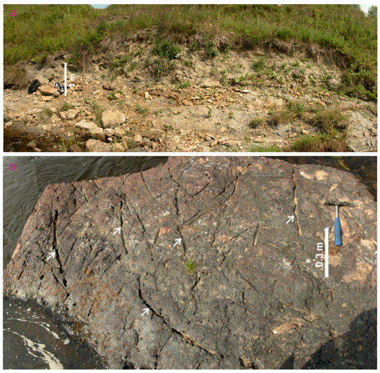
Figure 3.
Putlino fossil plant locality: (a)—panoramic view of the principal outcrop, (b)—sandstone block with multiple plant imprints indicated by arrows. Image (b) is republished from [50]; the rights belong to Y.V.M., and permission for republication is not required.
A rich assemblage of fossil plants was found in the above-mentioned siliciclastic beds (Figure 4a–d). This assemblage includes Bergeria puchkoviorum (Mosseichik 2017) Mosseichik 2023, Ogneuporia seleznevae Mosseichik 2004, Flemingites russiensis Mosseichik 2003, Stigmaria ficoides (Sternberg 1820) Ad. Brongniart 1822, Sphenophyllum cf. tenerrimum Ettingshausen 1874, Archaeocalamites spp., Mesocalamites rhombicus Mosseichik 2014, Archaeocalamitina weissii Mosseichik 2014, Dictyastrum pentagonum Mosseichik 2014, Grandeurites lyginopteroides Mosseichik 2011, Rynchogonium sp., Dadoxylon sp., Sphenopteris spp., and Sphenopteridium sp. [47].
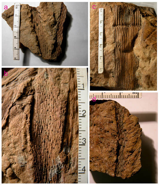
Figure 4.
Selected fossil plants from Putlino (scales are all in cm): (a)—Bergeria puchkoviorum (Mosseichik 2017) Mosseichik 2023, (b)—Dictyastrum pentagonum Mosseichik 2014, (c)—Mesocalamites rhombicus Mosseichik 2014, (d)—Ogneuporia seleznevae Mosseichik 2004. These images are republished from [47,50,51]; the rights belong to Y.V.M., and permission for republication is not required.
Yogla
This locality is situated close to Borovichi town, ~1.5 km southeast of the Putlino locality (Figure 1b). The outcrop is found near Yogla village, on the right bank of the Msta River. The Upper Yogla cataract was formed by the noted river crossing a hard limestone layer (Figure 5a) of the Putlino Formation and is of Visean age (Figure 1c). This cavernous detrital limestone is grey with violet spots, and in some places it is rose; its thickness is ~2.5 m. When the water level is low, the surface of this limestone layer is well exposed (Figure 2b), and one can see arborescent lycopod rhizopores Stigmaria ficoides (Sternberg 1820) Ad. Brongniart 1822 with in situ preservation (Figure 5b). These rhizophores reach 1 m in length and 10 cm in width.
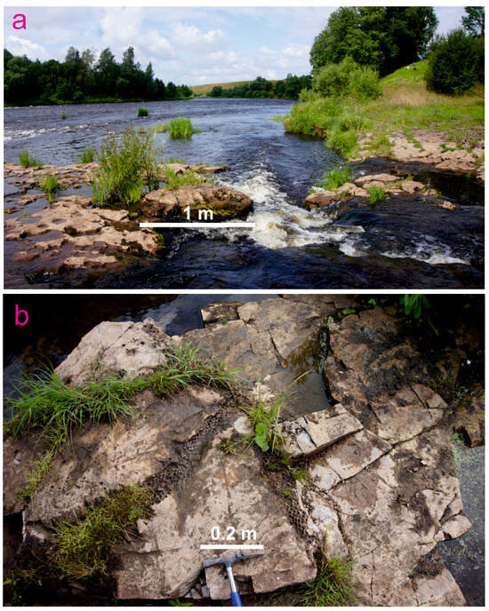
Figure 5.
Yogla fossil plant locality: (a)—representative outcrop, (b)—close view of fossiliferous rocks with imprints of Stigmaria ficoides (Sternberg 1820) Ad. Brongniart 1822 (stigmarian limestones).
Stigmarian limestones are a unique type of fossil plant preservation, which is typical to the Mississippian of the Moscow Basin. It is supposed that plants grew near a shoreline on soft calcareous silts that were exposed during sea regressions; even low-scale sea-level falls resulted in the exposure of these spaces that were quickly colonized by plants from a nearby land [29]. This is somewhat unusual evidence, because Stigmaria was commonly preserved in continental facies. This is why the information from the Yogla locality is important for the general understanding of the taphonomy and paleoecology of lycopods with Stigmaria rhizophores, which are in the focus of the contemporary paleobotanical research [52,53].
4.1.2. Tula Region
Georgievo
This locality is situated ~10 km west of Tula city (Figure 1b). This is a recently abandoned sand quarry near Georgievo village (Figure 2c). It has already received the official status of a protected area [31]. The exposed rocks are poorly lithified, cross-bedded, yellow and reddish-yellow quartz sands and sandstones with a visible thickness of 12 m (Figure 6a). They are attributed to the Tulskaya Formation of Visean age (Figure 1c). These deposits formed on an alluvial plain. The Visean package is overlain by thin Quaternary deposits.
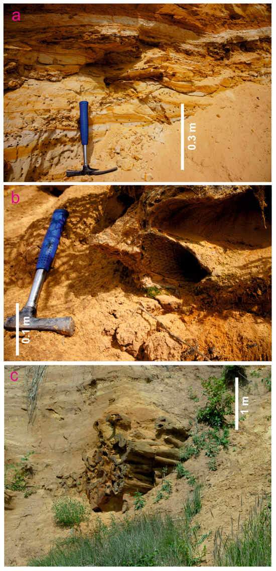
Figure 6.
Georgievo fossil plant locality: (a)—typical rocks, (b)—preservation of fossil plants, and (c)—“Tula pipes” (megaconcretions—see text for explanations).
Two features determine a high heritage value of this locality. The first of them is imprints and casts of fossil plants (Figure 6b and Figure 7a–c). Particularly, these include Lepidodendron veltheimioides Mosseichik 2009, Bergeria shvetzovii (Mosseichik 2003) Mosseichik 2023, B. puchkoviorum (Mosseichik 2017) Mosseichik 2023, Stigmaria ficoides (Sternberg 1820) Ad. Brongniart 1822, Mesocalamites sp., and Grandeurites sp.
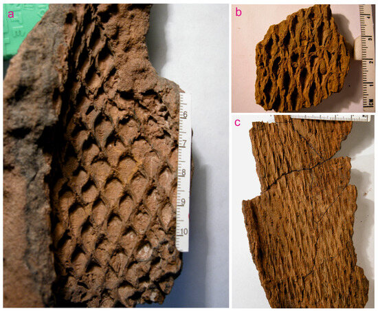
Figure 7.
Selected fossil plants from Georgievo (scales are everywhere in cm): (a)—Bergeria puchkoviorum (Mosseichik 2017) Mosseichik 2023, (b)—Bergeria shvetzovii (Mosseichik 2003) Mosseichik 2023, and (c)—Lepidodendron veltheimioides Mosseichik 2009. These images are republished from [31,47,54]; the rights belong to Y.V.M., and permission for republication is not required.
The second notable feature is the so-called “Tula pipes”, which are pipe-like, iron-rich megaconcretions (Figure 6c). These “pipes” are often oriented almost parallel to layering in Visean strata. Their visible length reaches 2 m. Their cross-sections differ, and they can be rounded, oval, or asymmetrical, with a diameter of up to 1 m. The “pipes” consist of sand particles and iron oxides, and the material inside them is commonly softer than on their margins. The width of their “walls” ranges from a few millimeters to a few centimeters. It is common when several “pipes” form compact sets. Such features associate with irregular, iron-rich surfaces in sandstones. The origin of the “Tula pipes” is related to post-depositional processes, circulation of groundwater, and presence of geochemical barriers in Visean deposits [31]. In other words, these objects are megaconcretions. It cannot be excluded that they inherit bioturbation developed in post-Carboniferous times (even in the Pleistocene when the study area was located close to a glacial zone). At a first glance, the “Tula pipes” may be erroneously misidentified as plant remains. However, their close examination excludes their relation to stems or other parts of fossil plants. Moreover, the latter did not reach a very impressive size in the Visean areas. Nonetheless, the “Tula pipes” remain rather enigmatic objects because post-depositional processes responsible for their formation are not yet known exactly. Any cultural interpretation of them was not registered (probably due to their exposure in a quarry and not in any natural outcrops known to local public).
Schyokino
This locality is situated 3 km west–southwest of Schyokino town, near the northern periphery of Krutovka village (Figure 1b). This is also a recently abandoned sand quarry, where poorly lithified, cross-bedded, yellow and reddish-yellow quartz sands and sandstones (~10 m) are exposed (Figure 2d and Figure 8a,b). These deposits are attributed to the Tulskaya Formation of Visean age (Figure 1c). They were accumulated on an alluvial plain. Thin Quaternary sediments cap the local sedimentary succession.
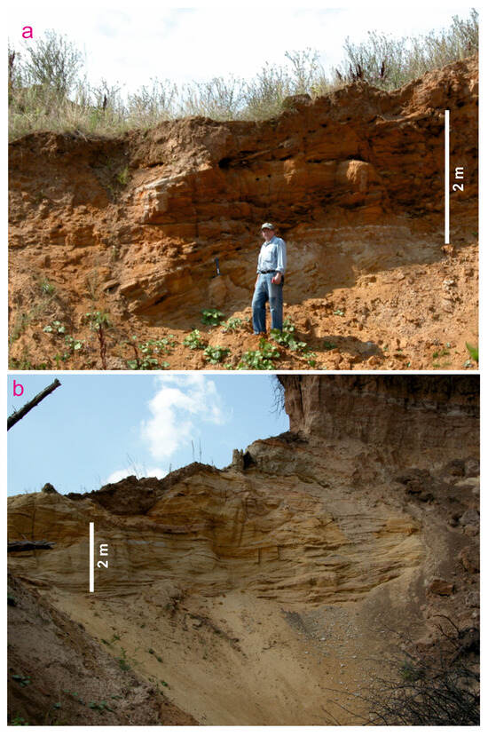
Figure 8.
Schyokino fossil plant locality: (a)—variegated rock exposure in quarry’s wall, (b)—another fragment of the locality with visible cross-bedding.
Sandstones bear numerous lepidophyte stems. The identified taxa include Lepidodendron veltheimioides Mosseichik 2009 and Ulodendron cf. moskovense (Zalessky 1944) Mosseichik 2017. Although the Schyokino locality resembles the Georgievo locality (see above), they are mutually important to comprehend Visean fossil plant assemblages of this segment of the Moscow Basin. Moreover, variegated rocks (Figure 8a) add visual value to the Schyokino quarry. It is possible that the package of variegated rocks includes paleosols, the horizons of which are common in this part of the Moscow Basin, and indicative of not only subaerial exposure, but also the paleoclimate [28].
4.2. Properties and Comparison of Geosites
The four localities of fossil plants of the Moscow Basin considered in this paper are important for the understanding of Visean floras of Baltica, i.e., a large eastern part of Laurussia. Although the localities are relatively small-sized, a significant number of fossils have been collected from there. Several taxa found at these localities are endemic to the Moscow Basin; these are Ogneuporia seleznevae Mosseichik 2004, Flemingites russiensis Mosseichik 2003, Mesocalamites rhombicus Mosseichik 2014, Archaeocalamitina weissii Mosseichik 2014, Dictyastrum pentagonum Mosseichik 2014, Grandeurites lyginopteroides Mosseichik 2011, Lepidodendron veltheimioides Mosseichik 2009, Bergeria shvetzovii (Mosseichik 2003) Mosseichik 2023, and B. puchkoviorum (Mosseichik 2017) Mosseichik 2023. Moreover, Archaeocalamitina weissii Mosseichik 2014 and Dictyastrum pentagonum Mosseichik 2014 were found in only Putlino. One should note that despite the large size of the Moscow Basin, the latter corresponds to a vast plain where outcrops are rare and small. This is why the considered localities have contributed substantially to the understanding of the Visean flora of the Moscow Basin [47]. No locality is principally better than the others because of some differences in their fossil plant assemblages and the preservation modes. The associated geological features also differ.
Taking into account the geological (especially paleobotanical) content and the considerations given above, these localities can be considered geosites. One of them (Georgievo) has already been designated officially [31], and three others are proposed as geosites in this work. The present study permits us to establish the properties of the four geosites (Table 2).
Table 2.
Properties of the considered geosites (see Table 1 for additional explanations; the geological content is not included in this table because it is explained in the descriptions provided above).
The properties of the geosites listed in Table 2 are explained below. First of all, geoheritage types are addressed (Table 2). The considered geosites are chiefly of paleontological (paleobotanical) interest. They also represent sedimentary features (e.g., “Tula pipes”), and they are important for paleoenvironmental interpretations. Two abandoned quarries show extractive activities of the nearest past. Moreover, both exemplify anthropogenic activities that disturb the geological environment on a global scale and are essential to contemporary civilization [55,56,57].
All considered geosites are located in the Russian countryside, i.e., both study areas of the Moscow Basin are rural (Table 2). Putlino and Yogla belong to the Mountainous Msta area, which is a geologically rich area with many outcrops and geological features exposed close to one another [30,38]. The noted geosites are members of a large entity of potential geosites, the inventory and description of which are a task for further investigations. In contrast, Georgievo and Schyokino are isolated geosites in the Tula Region. The Putlino geosite is complex and consists of several outcrops of Carboniferous rocks and Quaternary features scattered in the vicinity of Putlino village; the other geosites are singular (Table 2). The geosites look like small points, but it should be stressed that the small size does not limit their paleobotanical importance. Although all of them are static, the relation of Putlino and Yogla to the Msta River, with its erosive power, adds a dynamic component (Table 2). Notably, all geosites are distinguished by bright colors (Table 2, Figure 2). This contributes to their aesthetics and also facilitates rock visibility.
The geosites differ by their rarity (Table 2). Yogla seems to be globally rare due to the in situ preservation of Stigmaria in marine carbonate rocks. The “Tula pipes” make Georgievo rare on a national scale. Two other geosites (Putlino and Schyokino) exhibit important information, but they are rare on the only level of the regions where they are situated (Novgorod and Tula regions, respectively). It is very important that all geosites are accessible (Table 2), and one can reach them with cars or public transport. Walking within these geosites is easy, although the high water level of the Msta River may seasonally limit the internal accessibility of Putlino and especially Yogla.
Indeed, the erosive power of the noted river and landslide risks make Putlino and Yogla potentially vulnerable, and risks for Georgievo and Shyokino are higher (Table 2). If these quarries remain inactive, slope collapses and the expansion of vegetation cover will affect exposures of fossiliferous rocks. If sand extraction restarts, damage to geoheritage features will be large. Nonetheless, these are only potential dangers. It is worth noting that all these localities have been visited by experts and, presumably, amateurs for years (even decades in the case of Mountainous Msta), and these activities have not led to their damage or depletion. Moreover, the official status and the related protection measures considered below should help to minimize these risks.
All considered geosites exhibit geological features, which are difficult to understand without professional geological knowledge (Table 2). At least, the age of fossil plants needs careful explanation, and such features as the “Tula pipes” can easily be misinterpreted, even by some professionals.
Importantly, all these geosites have already been used for the purposes high-class stratigraphical and paleogeographical research, with rather numerous and important outcomes [38,47], and they can be employed in subsequent, advanced investigations (Table 2). First of all, these localities can be used for further paleobotanical studies. Moreover, there can be research projects addressing, for instance, the highly complex and yet to be fully understood Carboniferous stratigraphy of the Mountainous Msta area and the origin of the “Tula pipes”. Special attention should be paid to paleosols and their paleoclimatic interpretations, following the earlier developments by Alekseeva et al. [28]. Geological features of two geosites of the Tula Region are suitable for the basic geological learning of schoolchildren and undergraduate students, and two geosites of the Mountainous Msta area can be used in advanced geological learning for graduate and post-graduate students (Table 2). In all cases, it is supposed that geoeducation will be conducted under the guidance of experts, because these geosites cannot be understood without professional knowledge (see above). Regarding the potential touristic significance, it is clear that three sites will primarily attract professionals, while the “Tula pipes” may appeal to a wider audience of geotourists due to their unique features (Table 2). Finally, the geosites of the Mountainous Msta area demonstrate significant natural scenery linked to the turbulent flow and cataracts of the Msta River (Figure 9a,b) and typical hilly landscape of the Russian Plain, which inspires by its grandeur (Figure 9c). Georgievo and Shyokino bear aesthetically notable geological features linked to rock colors and structural peculiarities (Figure 2c and Figure 8a), but the general natural scenery in their vicinity is quite ordinary (Table 2). Nonetheless, this observation cannot be used as an argument against geosites.
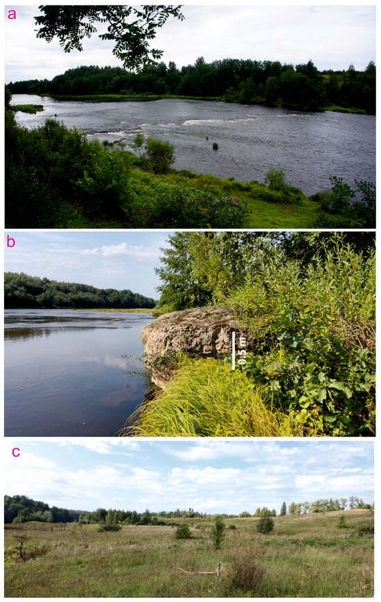
Figure 9.
Natural scenery of Mountainous Msta area: (a,b)—picturesque landscapes along the Msta River (a also depicts the Yogla cataract), (c)—hilly landscapes of the adjacent parts of the Russian Plain.
The status of the considered geosites differs (Table 2). Georgievo in the Tula Region is the only geosite already proposed as such. Joint efforts of scientists, local nature amateurs, and administrative authorities led to the designation of Georgievo as a monument of nature [31]. A monument of nature is a kind of protected area that is established officially in Russia. This status involves inclusion in lists of protected areas and creates a legal basis for conservation measures. One should also note that such a status requires significant limitations, including those for fossil collecting. The regular monitoring of the locality and local infrastructural developments (e.g., installing fences) are also possible and desirable with this status under the leading role of the regional administration. Indeed, this official designation should minimize the above-mentioned risks for this geosite. The situation with the three other geosites differs. On the one hand, none of them has an official status, and they are proposed as geosites in the present work. On the other hand, Putlino and Yogla are situated in the Mountainous Msta area, which has already attracted the attention of the regional administration. The first step was the creation of the local ecological trail, which serves tourists and also lays a foundation for further nature protection efforts. The second step was an official inclusion of the Putlino and Yogla areas into a natural park. The latter has been planned and will be created in the nearest future (expectedly, before the end of the 2020s). This natural park will also be a kind of protected area with a special regime and maintenance. If so, it is unnecessary to establish any official status for Putlino and Yogla geosites, because their location in the natural park will make them protected adequately. Finally, Schyokino is proposed as a geosite in the present work. It appears reasonable to designate it as a monument of nature, which can be accomplished by analogy with Georgievo. This is a task for further practical geoconservation developments in the Tula Region.
5. Discussion and Conclusions
The present examination of the four fossil plant localities from the northwestern and southern segments of the Moscow Basin reveals their peculiarities as geosites. Realizing their full geological importance and research potential requires their consideration in a broader perspective. In the Visean, a large supercontinent, Pangea, existed, and it was divided by huge orogenic belts [58,59,60]. Laurussia, i.e., Laurentia merged with Baltica, was a northern part of this supercontinent. The Moscow Basin represents central Baltica, i.e., an eastern part of the Laurussian landmass. According to Scotese [56], this territory was located in the northern hemisphere and very close to the equator. A sea occupied about a half of the Baltic counterpart of Laurussia, and it persisted in its eastern part (in modern coordinates, this is a southeastern part) [19,59,61]. Global sea-level fluctuations facilitated multiple transgressions and regressions, when shallow-marine conditions interrupted by the development of broad alluvial plains (Figure 10). Although glaciations took place in the Visean [62] and the climate of this stage was colder than in some other time slices of the Carboniferous period [63], temperatures were not too low in low latitudes, and they were more or less comparable to those of the late Cenozoic era [64]. Therefore, a true equatorial paleoenvironment can be assumed for the Moscow Basin. Taking into account this paleogeographical situation, the considered geosites represent equatorial vegetated landscapes developed in a zone of interplay between alluvial plains and shallow seas.
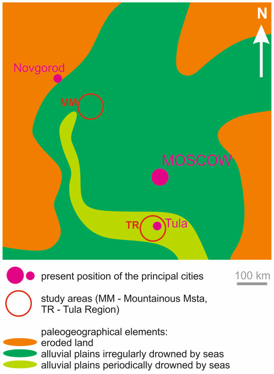
Figure 10.
Paleogeographical location of the study areas (strongly simplified from [58]).
The potential vulnerability of all geosites (Table 2) makes urgent the development of recommendations for their adequate geoconservation. Three activities can be proposed as follows. First, a periodicity of their monitoring should be established and strictly followed. This is necessary to effectively mitigate any increased risk or to stop any negative influence. Moreover, monitoring will indicate the possible need for slope stabilization and cleaning. Second, signs warning against uncontrolled fossil collecting have to be installed. Although it is unlikely that amateurs may overcollect fossils in the considered geosites, protecting fences can be constructed in the case of such risks. Third, it is necessary to realize the existence of paleobotanical material that can be damaged by running water or slope processes for its subsequent extraction and preservation in museums (the latter are available in all study areas—see below). The official status of protected areas means that regional administrations and other authorities are responsible for their sustainable management. In the Mountainous Msta area, the exploitation of the existing ecological trail and the creation of a natural park in the nearest future (Table 2) can change the anthropogenic pressure in the future. On the one hand, these establishments can contribute to better geoconservation. On the other hand, they will attract more visitors and require some infrastructure development. If so, the vulnerability of Putlino and Yogla may increase, and this property will require additional examination. In the Tula Region, the active development of tourism may also trigger higher risks; thus, the vulnerability of Georgievo and Schyokino will also need special monitoring in the future.
The relative complexity of the geological information from the geosites (Table 2 and see above) challenges their importance to tourism development. Apparently, these sites would be interesting chiefly to academic geotourists, i.e., professional geologists and paleontologists (also accompanied by students) wishing to extend their knowledge. Specially organized pre- and post-conference excursions seem to be a prospective form of geotourism. Nonetheless, one should note the significant tourism potential and its active exploitation in the Novgorod and Tula regions, where the study areas are located [65,66]. The growth of tourism and, particularly ecological and rural tourism, requires diversification of the related activities, experiences, and impressions via the extension of programs and tours. Attention to the international experience in geotourism development in rural areas [67,68] and local creative solutions [69] will help to exploit the considered geosites for the purposes of the local tourism industry. Moreover, well-organized museums with a natural history focus are already available in Borovichi town (Mountainous Msta) and Tula city (Tula Region), and these can become centers for the professional management of the considered geosites and responsible coordination of geoconservation and geotouristic activities.
Conclusively, four geosites can be specified to represent Visean plant localities from the Moscow Basin, and particularly its northwestern and southern segments. Their geological and paleontological content and geoheritage properties differ, but all of them are important to provide information about the mid-Early Carboniferous equatorial landscapes of Baltica. Two geosites are globally or nationally rare, and all geosites have already contributed to the growth of paleobotanical knowledge, and they retain potential for future research. The vulnerability of these geosites and its possible changes in the future constitute an important topic for further geoconservation research in the considered areas. More generally, the outcomes of the present work indicate the high potential for geoheritage studies in the Moscow Basin, with its Carboniferous rocks and fossils. Indeed, no single study can embrace all geoheritage features of this basin due to its huge territory. This ambitious task can be solved step-by-step, and the present work should be followed by reports of both similar and distinct geosites from the other areas and segments of this important domain. This study also reveals the presence of geoheritage features in two regions of Russia, namely the Novgorod Region and the Tula Region. Indeed, some other interesting localities (geological and paleontological) can be found there; thus, regional geoheritage inventories are on the agenda.
Author Contributions
Conceptualization, Y.V.M., N.N.Y. and D.A.R.; methodology, Y.V.M. and D.A.R.; investigation, Y.V.M., I.A.I., N.N.Y. and D.A.R.; writing—original draft preparation, Y.V.M., I.A.I., N.N.Y. and D.A.R. All authors have read and agreed to the published version of the manuscript.
Funding
The research of Y.V.M. and I.A.I. was supported by the Russian State program of the Geological Institute of Russian Academy of Sciences. The contribution by D.A.R. was funded by the subsidy allocated to Kazan Federal University for the state assignment project no. FZSM-2023-0023 in the sphere of scientific activities. The contribution of N.N.Y. received no external funding.
Data Availability Statement
Data are contained within the article.
Acknowledgments
Y.V.M. and I.A.I. thank A.F. Lakomov (Tula Region Local History Museum, Tula, Russia) and L.V. Nikolaeva, V.A. Nikolaev, and V.Y. Artemiev (Mountainous Msta travel agency, Borovichi, Russia) for their help in the field and general support. Y.V.M. and D.A.R. thank A.J. van Loon (Spain/China) for preliminary discussions of the “Tula pipes”. N.N.Y. thanks her family members for field assistance.
Conflicts of Interest
The authors declare no conflicts of interest. The funders had no role in the design of the study; in the collection, analyses, or interpretation of data; in the writing of the manuscript; or in the decision to publish the results. The rights to the republished images belong to Y.V.M., and special permission for their republication is not required.
References
- Burke, P.J.C.; Mayer, P.S.; McCoy, V.E. Mazon Creek fossils brought to you by coal, concretions and collectors. Geol. Soc. Spec. Publ. 2024, 543, 179–192. [Google Scholar] [CrossRef]
- Dinis, J.L.; Oliveira, F.P.; Rey, J.; Duarte, I.L. Finding Geological Heritage: Legal Issues on Private Property and Fieldwork. The Case of Outstanding Early Angiosperms (Barremian to Albian, Portugal). Geoheritage 2010, 2, 77–90. [Google Scholar] [CrossRef]
- Leipner, A.; Fischer, T.; Chellouche, P. The Piesberg: A NW-German site of international importance for the Pennsylvanian (Late Carboniferous). Geoconserv. Res. 2021, 4, 218–234. [Google Scholar]
- Martinetto, E.; Caleca, R. Overview of Pliocene plant macrofossil localities of the Piemonte region (NW Italy) with a partial analysis of palaeobotanical and geoconservation interest. Acta Palaeobot. 2024, 64, 75–108. [Google Scholar] [CrossRef]
- Meakin, S. Geodiversity of the lightning ridge area and implications for geotourism. Proc. Linn. Soc. N. S. W. 2011, 132, 71–82. [Google Scholar]
- Mencl, V.; Mikuláš, R.; Nedvědická, B. Late Paleozoic Petrified Trees of the Bohemian Paradise—An Insight into the Tropical Forest in Central Europe. Geoconserv. Res. 2021, 4, 235–244. [Google Scholar]
- Strullu-Derrien, C.; Spencer, A.R.T.; Cleal, C.J.; Leshyk, V.O. The 330–320 Million-Year-Old Tranchée des Malécots (Chaudefonds-sur-Layon, South of the Armorican Massif, France): A Rare Geoheritage Site Containing In Situ Palaeobotanical Remains. Geoheritage 2022, 14, 42. [Google Scholar] [CrossRef]
- Edwards, D. Climate signals in Palaeozoic land plants. Philos. Trans. R. Soc. B Biol. Sci. 1998, 353, 141–157. [Google Scholar] [CrossRef]
- Opluštil, S.; Cleal, C.J.; Wang, J.; Wan, M. Carboniferous macrofloral biostratigraphy: An overview. Geol. Soc. Spec. Publ. 2022, 512, 813–863. [Google Scholar] [CrossRef]
- Roberts, R. Brymbo Fossil Forest: A Sustainable Management of Natural Resources (SMNR) Approach to Geoconservation and Geotourism. Geoheritage 2019, 11, 1325–1334. [Google Scholar] [CrossRef]
- Thomas, B.A. A Carboniferous Fossil Forest in North Wales: Problems and Potentials Associated with Developing and Conserving a ‘Soft-Rock’ Site. Geoheritage 2016, 8, 401–406. [Google Scholar] [CrossRef][Green Version]
- Wilson, J.P.; Montañez, I.P.; White, J.D.; DiMichele, W.A.; McElwain, J.C.; Poulsen, C.J.; Hren, M.T. Dynamic Carboniferous tropical forests: New views of plant function and potential for physiological forcing of climate. New Phytol. 2017, 215, 1333–1353. [Google Scholar] [CrossRef] [PubMed]
- Gradstein, F.M.; Ogg, J.G.; Schmitz, M.D.; Ogg, G.M. (Eds.) Geologic Time Scale 2020; Elsevier: Amsterdam, The Netherlands, 2020. [Google Scholar]
- International Commission on Stratigraphy. Available online: https://stratigraphy.org/ (accessed on 5 March 2025).
- Cascales-Miñana, B. Apparent changes in the Ordovician-Mississippian plant diversity. Rev. Palaeobot. Palynol. 2016, 227, 19–27. [Google Scholar] [CrossRef]
- Pfefferkorn, H.W.; Alleman, V.; Iannuzzi, R. A greenhouse interval between icehouse times: Climate change, long-distance plant dispersal, and plate motion in the Mississippian (late Visean-earliest Serpukhovian) of Gondwana. Gondwana Res. 2014, 25, 1338–1347. [Google Scholar] [CrossRef]
- Scott, A.C. The anatomically preserved Early Carboniferous flora of Pettycur, Fife, Scotland. Proc. Geol. Assoc. 2024, 135, 389–415. [Google Scholar] [CrossRef]
- Kolodyazhny, S.Y.; Poleshchuk, A.V.; Zykov, D.S. Latent Tectonics of the Central Russian Deformation Belt of the East European Platform. Geotectonics 2021, 55, 473–501. [Google Scholar] [CrossRef]
- Nikishin, A.M.; Ziegler, P.A.; Stephenson, R.A.; Cloetingh, S.A.P.L.; Furne, A.V.; Fokin, P.A.; Ershov, A.V.; Bolotov, S.N.; Korotaev, M.N.; Alekseev, A.S.; et al. Late Precambrian to Triassic history of the East European Craton: Dynamics of sedimentary basin evolution. Tectonophysics 1996, 268, 23–63. [Google Scholar] [CrossRef]
- Cocks, L.R.M.; Torsvik, T.H. Baltica from the late Precambrian to mid-Palaeozoic times: The gain and loss of a terrane’s identity. Earth-Sci. Rev. 2005, 72, 39–66. [Google Scholar] [CrossRef]
- Golonka, J.; Porębski, S.J.; Barmuta, J.; Papiernik, B.; Bebenek, S.; Barmuta, M.; Botor, D.; Pietsch, K.; Słomka, T. Palaeozoic palaeogeography of the East European Craton (Poland) in the framework of global plate tectonics. Ann. Soc. Geol. Pol. 2019, 89, 381–403. [Google Scholar] [CrossRef]
- Kalvoda, J.; Bábek, O. The Margins of Laurussia in Central and Southeast Europe and Southwest Asia. Gondwana Res. 2010, 17, 526–545. [Google Scholar] [CrossRef]
- Vai, G.B. Development of the palaeogeography of Pangaea from Late Carboniferous to Early Permian. Palaeogeogr. Palaeoclimatol. Palaeoecol. 2003, 196, 125–155. [Google Scholar] [CrossRef]
- Hasterok, D.; Halpin, J.A.; Collins, A.S.; Hand, M.; Kreemer, C.; Gard, M.G.; Glorie, S. New Maps of Global Geological Provinces and Tectonic Plates. Earth-Sci. Rev. 2022, 231, 104069. [Google Scholar] [CrossRef]
- Alekseev, A.S.; Kononova, L.I.; Nikishin, A.M. The Devonian and Carboniferous of the Moscow Syneclise (Russian Platform): Stratigraphy and sea-level changes. Tectonophysics 1996, 268, 149–168. [Google Scholar] [CrossRef]
- Iosifidi, A.G.; Mikhailova, V.A.; Popov, V.V.; Sergienko, E.S.; Danilova, A.V.; Otmas, N.M. The Carboniferous of the Moscow syneclise: Paleomagnetic data. Izv. Phys. Solid Earth 2018, 54, 163–177. [Google Scholar] [CrossRef]
- Makhlina, M.K. Cyclic stratigraphy, facies and fauna of the Lower Carboniferous (Dinantian) of the Moscow Syneclise and Voronezh Anteclise. Geol. Soc. Spec. Publ. 1997, 107, 359–364. [Google Scholar] [CrossRef]
- Alekseeva, T.V.; Alekseev, A.O.; Gubin, S.V.; Kabanov, P.B.; Alekseeva, V.A. Palaeoenvironments of the Middle-Late Mississippian Moscow Basin (Russia) from multiproxy study of palaeosols and palaeokarsts. Palaeogeogr. Palaeoclimatol. Palaeoecol. 2016, 450, 1–16. [Google Scholar] [CrossRef]
- Mosseichik, Y.V.; Ruban, D.A. Viséan flora from the Moscow Coal Basin (Baltic Plate; European Russia): Local evolution in the context of global tendencies. Palaeogeogr. Palaeoclimatol. Palaeoecol. 2010, 292, 168–183. [Google Scholar] [CrossRef]
- Karpunin, A.M.; Mamonov, S.V.; Mironenko, O.A.; Sokolov, A.R. Geological Monuments of Nature of Russia; Lorien: Moscow, Russia, 1998; 200p. (In Russian) [Google Scholar]
- Mosseichik, Y.V.; Privalova, M.V.; Ignatiev, I.A.; Kuralenko, N.P.; Smirnova, E.V.; Muchnik, E.E.; Evsyunin, A.A.; Lakomov, A.F. A unique geological-paleobotanical monument of nature in the Tula Region (Russia). Lethaea Ross. 2024, 27, 1–13. (In Russian) [Google Scholar]
- Yablokov, V.S. A History of Studies of Carboniferous Deposits and Coals of the Moscow Basin (1722–1966); Nauka: Moscow, Russia, 1967; 260p. (In Russian) [Google Scholar]
- Makhlina, M.K.; Vdovenko, M.V.; Alekseev, A.S.; Byvsheva, T.V.; Donakova, L.M.; Zhulitova, V.E.; Kononova, L.I.; Umnova, N.I.; Shik, E.M. Lower Carboniferous of the Moscow Syneclise and the Voronezh Anteclise; Nauka: Moscow, Russia, 1993; 222p. (In Russian) [Google Scholar]
- Osipova, A.I.; Bel’skaya, T.N.; Gekker, R.F. A study of ecology and development of the main groups of benthos in Carboniferous seas of the Russian Platform. Treatise Paleontol. Inst. Acad. Sci. USSR 1983, 194, 98–119. [Google Scholar]
- Aleksseev, A.S.; Nikolaeva, S.V.; Goreva, N.V.; Donova, N.B.; Kossovaya, O.L.; Kulagina, E.I.; Kucheva, N.A.; Kurilenko, A.V.; Kutygin, R.V.; Popeko, L.I.; et al. Russian regional Carboniferous stratigraphy. Geol. Soc. Lond. Spec. Publ. 2022, 512, 49–117. [Google Scholar] [CrossRef]
- Decision of the Interdepartmental Regional Stratigraphical Meeting on the Middle and Upper Paleozoic of the Russian Platform; Leningrad, Russia, 1990; 95p. (In Russian)
- Stratigraphical Dictionary of USSR. New Stratigraphical Subdivisions of the Paleozoic of USSR; Nedra: Leningrad, Russia, 1991; 555p. (In Russian) [Google Scholar]
- Porshnyakov, S.N.; Porshnyakov, G.S. Geological Excursion in the Vicinity of Borovichi Town (a Guide to Excursion Guiders); GEOS: Moscow, Russia, 2021; 128p. (In Russian) [Google Scholar]
- Brilha, J. Inventory and Quantitative Assessment of Geosites and Geodiversity Sites: A Review. Geoheritage 2016, 8, 119–134. [Google Scholar] [CrossRef]
- Carrión-Mero, P.; Arcentales-Rosado, M.; Jaya-Montalvo, M.; Briones-Bitar, J.; Duenas-Tovar, J.; Espinel, R.L.; Mata-Perelló, J.; Morante-Carballo, F. Assessment of geosites and geotouristic routes proposal for geoheritage promotion on volcanic islands. Geomorphology 2025, 472, 109606. [Google Scholar] [CrossRef]
- Gutak, J.M.; Ruban, D.A. Neverovsky Palaeoreef and Associated Deep-Marine Facies: High-Value Late Devonian Geoheritage from the Rudny Altai. Heritage 2024, 7, 2385–2398. [Google Scholar] [CrossRef]
- Kubalíková, L. Risk assessment on dynamic geomorphosites: A case study of selected abandoned pits in South-Moravian Region (Czech Republic). Geomorphology 2024, 458, 109249. [Google Scholar] [CrossRef]
- Kudla, M.; Javorská, M.; Vašková, J.; Čech, V.; Tometzová, D. Inventory and Evaluation of Geosites: Case Studies of the Slovak Karst as a Potential Geopark in Slovakia. Sustainability 2024, 16, 7783. [Google Scholar] [CrossRef]
- Pasquaré Mariotto, F.; Drymoni, K.; Bonali, F.L.; Tibaldi, A.; Corti, N.; Oppizzi, P. Geosite Assessment and Communication: A Review. Resources 2023, 12, 29. [Google Scholar] [CrossRef]
- Szepesi, J.; Ésik, Z.; Soós, I.; Novak, T.; Suto, L.; Rozsa, P.; Lukács, R.; Harangi, S. Methodological review of geosite inventory and assessment work in the light of protection, sustainability and the development of geotourism. Foldt. Kozlony 2018, 148, 143–160. [Google Scholar]
- Yaseen, M.; Ahmad, J.; Anjum, M.N.; Naseem, A.A.; Shah, S.T. Characterization and Quantification of Outcrops Exposed Along the Karakoram Highway (KKH) and Part of Central Karakoram National Park (CKNP), North Pakistan; Implications for Geoheritage Assessments and Geosite Recognition. Geoheritage 2024, 16, 107. [Google Scholar] [CrossRef]
- Mosseichik, Y.V. Early Carboniferous Flora of the Moscow Basin; GEOS: Moscow, Russia, 2009, 2014; Volume 1,2. [Google Scholar]
- Kirillova, K. A review of aesthetics research in tourism: Launching the Annals of Tourism Research Curated Collection on beauty and aesthetics in tourism. Ann. Tour. Res. 2023, 100, 103553. [Google Scholar] [CrossRef]
- Kirillova, K.; Fu, X.; Lehto, X.; Cai, L. What makes a destination beautiful? Dimensions of tourist aesthetic judgment. Tour. Manag. 2014, 42, 282–293. [Google Scholar] [CrossRef]
- Mosseichik, Y.V.; Gomankov, A.V.; Ignatiev, I.A. A Paleobotanical Excursion Guide to Lower Carboniferous Sections of the Northwestern Wing of the Moscow Basin (Vicinities of Borovichi Town, Novgorod Region); GEOS: Moscow, Russia, 2021; 38p. (In Russian) [Google Scholar]
- Mosseichik, Y.V. New data on lepidodendroid lycopods from the Lower Carboniferous of the Moscow Basin. Lethaea Ross. 2023, 26, 1–17. (In Russian) [Google Scholar]
- D’Antonio, M.P.; Breasley, C.M.; Pfefferkorn, H.W.; Wang, J.; Boyce, C.K. Stigmaria: On the substrate before in the substrate. Palaeoworld 2024, 33, 925–936. [Google Scholar] [CrossRef]
- Dimichele, W.A.; Bateman, R.M.; Rothwell, G.W.; Duijnstee, I.A.P.; Elrick, S.D.; Looy, C.V. Stigmaria: A review of the anatomy, development, and functional morphology of the rootstock of the arboreous lycopsids. Int. J. Plant Sci. 2022, 183, 493–534. [Google Scholar] [CrossRef]
- Mosseichik, Y.V.; Ignatiev, I.A. Visean lycopods from the Moscow Basin: New species and suprageneric affinity. Lethaea Ross. 2017, 15, 1–19. [Google Scholar]
- Ioannidou, D.; Sonnemann, G.; Suh, S. Do we have enough natural sand for low-carbon infrastructure? J. Ind. Ecol. 2020, 24, 1004–1015. [Google Scholar] [CrossRef]
- Lamb, V. Constructing the global sand crisis: Four reasons to interrogate crisis and scarcity in narrating extraction. Extr. Ind. Soc. 2023, 15, 101282. [Google Scholar] [CrossRef]
- Torres, A.; Simoni, M.U.; Keiding, J.K.; Muller, D.B.; zu Ermgassen, S.O.S.E.; Liu, J.; Jaeger, J.A.G.; Winter, M.; Lambin, E.F. Sustainability of the global sand system in the Anthropocene. One Earth 2021, 4, 639–650. [Google Scholar] [CrossRef]
- González, F.; Moreno, C.; Playford, G. The Gondwana-Laurussia convergence process: Evidence from the Middle Mississippian (Viséan) palynostratigraphic record. Geol. Mag. 2011, 148, 317–328. [Google Scholar] [CrossRef]
- Scotese, C.R. An Atlas of Phanerozoic Paleogeographic Maps: The Seas Come In and the Seas Go Out. Annu. Rev. Earth Planet. Sci. 2021, 49, 679–728. [Google Scholar] [CrossRef]
- Xu, Y.; Han, B.-F.; Liao, W.; Li, A. The Serpukhovian–Bashkirian Amalgamation of Laurussia and the Siberian Continent and Implications for Assembly of Pangea. Tectonics 2022, 41, e2022TC007218. [Google Scholar] [CrossRef]
- Frank, T.D.; Birgenheier, L.P.; Montañez, L.P.; Fielding, C.R.; Rygel, M.C. Late Paleozoic climate dynamics revealed by comparison of ice-proximal stratigraphic and ice-distal isotopic records. Spec. Pap. Geol. Soc. Am. 2008, 441, 331–342. [Google Scholar]
- Powell, M.G.; Schöne, B.R.; Jacob, D.E. Tropical marine climate during the late Paleozoic ice age using trace element analyses of brachiopods. Palaeogeogr. Palaeoclimatol. Palaeoecol. 2009, 280, 143–149. [Google Scholar] [CrossRef]
- Grossman, E.L.; Joachimski, M.M. Ocean temperatures through the Phanerozoic reassessed. Sci. Rep. 2022, 12, 8938. [Google Scholar] [CrossRef]
- Vinogradov, A.P. (Ed.) Atlas of lithological-palaeogeographical maps of the Russian Platform and its geosynclinals vicinity. In Scale 1:5000000. Part 1. Late Precambrian and Paleozoic; MinGeo SSSR: Moscow, Russia, 1961. (In Russian) [Google Scholar]
- Stepanova, A.A.; Dmitruk, N.G. The current state of tourist and recreational activities in rural areas of the Novgorod region. IOP Conf. Ser. Earth Environ. Sci. 2020, 613, 012145. [Google Scholar] [CrossRef]
- Tankieva, T.A.; Ponomareva, M.V. A study of consumers and the development problems of industrial tourism in the old industrial region (on the example of the Tula region). J. New Econ. Assoc. 2021, 49, 165–183. [Google Scholar] [CrossRef]
- Cengiz, C.; Şahin, Ş.; Cengiz, B.; Başkır, M.B.; Dağlı, P.K. Evaluation of the visitor understanding of coastal geotourism and geoheritage potential based on sustainable regional development in western black sea region, Turkey. Sustainability 2021, 13, 11812. [Google Scholar] [CrossRef]
- Mastika, I.K.; Harsono, S.S.; Khristianto, W.; Oktawirani, P.; Hutama, P.S. Creative strategies of local resources in managing geotourism in the Ijen Geopark Bondowoso, East Java, Indonesia. Int. J. Geoherit. Parks 2023, 11, 149–168. [Google Scholar] [CrossRef]
- Górska-Zabielska, M. New Geoeducational Facilities in Central Mazovia (Poland) Disseminate Knowledge about Local Geoheritage. Sustainability 2023, 15, 16115. [Google Scholar] [CrossRef]
Disclaimer/Publisher’s Note: The statements, opinions and data contained in all publications are solely those of the individual author(s) and contributor(s) and not of MDPI and/or the editor(s). MDPI and/or the editor(s) disclaim responsibility for any injury to people or property resulting from any ideas, methods, instructions or products referred to in the content. |
© 2025 by the authors. Licensee MDPI, Basel, Switzerland. This article is an open access article distributed under the terms and conditions of the Creative Commons Attribution (CC BY) license (https://creativecommons.org/licenses/by/4.0/).