3.1. Triassic Period
During the Triassic, land dominated over the sea in the territory of central Eurasia. Large marine basins were located consistently in the east of the area, connecting the basins and the Boreal and Pacific Oceans. A narrow marine strip to the south, which comprised the marginal seas of Tethys, stretched in the south of the country from the Crimea and the Caucasus and into Central Asia. In the Norian Age, the marine basins regressed from the territory of the southern part of the Caspian. The marine basin penetrated from the west into the area far to the north of the modern Barents Sea. The Ural Mountains, cut across by rivers in many parts right up to the Trans-Urals, probably remained during the Triassic as a belt of island mountains at the end of the Permian, and these mountains were quite high in the extreme south to the east of Orenburg to Aqtobe areas.
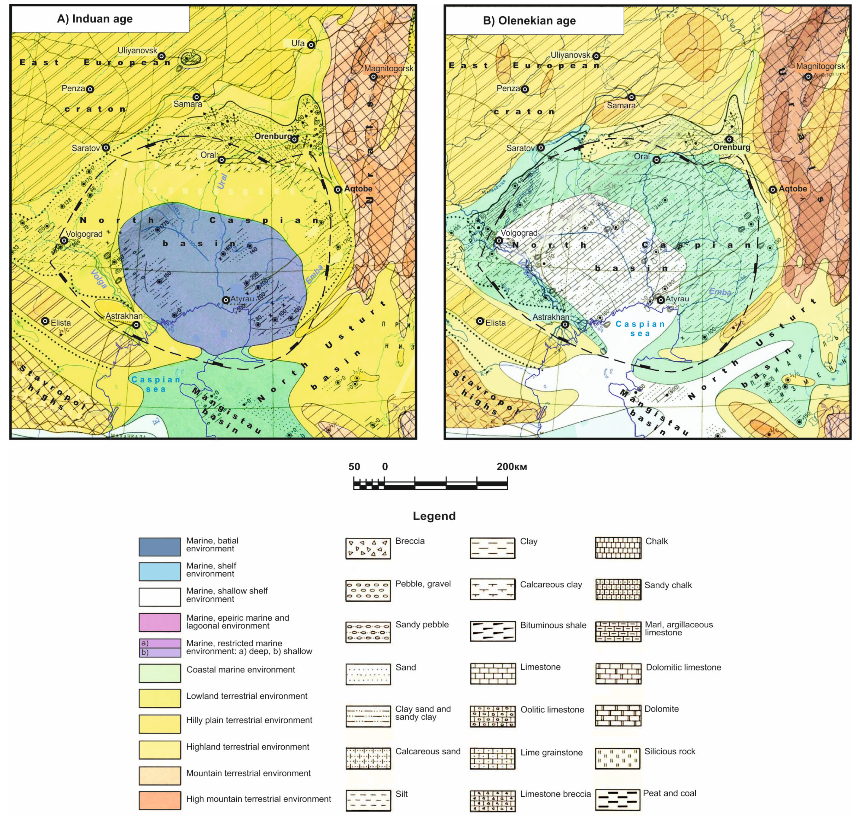
Early Triassic Induan Age: At the end of the Permian, there was a short-term uplift of the East European craton, which began somewhat earlier in the northern regions. At the beginning of the Induan Age (
Figure 4A), subsidence began again, but over a much smaller area than in the Late Permian. As a result, the vast area of sediment accumulation that existed at the end of the Permian broke up into isolated areas of continental sedimentation, with erosion bases located in the north and south. A relatively large freshwater basin in the Induan Age sometimes existed only in the southern part of the Caspian lowland and, apparently, covered the northern part of the Caspian region. During other periods, a number of large reservoirs with constantly changing contours were probably located here. Desiccation cracks confirm the repeated replacement of subaqueous conditions by subaerial ones in certain areas. Numerous ripple marks and cross-bedding phenomenon indicate their shallow waters. For certain periods, it is assumed that the North Caspian Basin had a connection with the west Caucasus Sea through the Mangistau and Tuarkyr regions to the south.
The Caspian Lowland is adjacent to the basin from the north and borders the east, with the southern part of the Ural Mountain region bordering this area and, in the west, their borders. Numerous rivers flowed into it from the Urals, dumping pebble and sand materials in the Magnitogorst and Orenburg Uralian regions. In the lowland area, the hydrographic network was apparently well developed, as can be observed via the local increase in the thickness of sandy sediments and by the multi-tiered horizons of sand with distinct cross-bedding phenomenon.
From the northwest, the Caspian Lowland was connected with the western areas (Dnieper–Donets Lowland). In the Caspian Lowland, which bordered the desalinated basin from the northwest and northeast—the contours of which apparently changed and the basin greatly contracted at times—sediments accumulated in river valleys, fresh lakes, and deltas.
The latter were especially developed in the northeast of the lowland, where the rivers flowing down from the Ural Mountains unloaded. The desalinated basin, located in the south near the modern Caspian Sea, was apparently connected with the Caucasus Sea through Mangistau. In the North Usturt region south of the Urals, during the Early Triassic, it is assumed that there was a vast freshwater basin, which at times was dissected with the formation of an accumulative alluvial–lacustrine plain. Clayey red beds and silt and sandy polymictic sediments were deposited under these conditions. The south of the Urals was also a source of erosion. No traces of marine organisms were found in the resulting deposits, but glauconite grains were found in individual layers. Thus, at times, the hydrochemical regime of the reservoir may have been a normal marine regime due to the penetration of seawater from the Caucasian Sea. The enlargement of fragments and the increased role of sandstones from the west to the east—established in the Karatau Mountains on Mangistau—are also observed in the surrounding areas and indicate the proximity of the erosion areas. Thus, in Mangistau and Buzachi, the sandstones are usually fine-grained; in North Ustyurt (Terenkuduk well), they are medium-grained; in the east (Kulanda well), they are coarse-grained.
Olenekian Age: In the second half of the Olenekian Age, significant changes in the paleogeographic environment occurred due to transgression in the west, Mangistau, and the North Caspian Depression (
Figure 4B). It is assumed that sediment accumulation occurred in two separate depressions: in the eastern depression, it was mainly sandy material that accumulated, which was brought from the Urals; meanwhile, in the western depression, mainly siltstones and clays were introduced. Sediment accumulation occurred in river valleys and lakes. In the Caspian Lowland, this did not substantially change at the beginning of the Olenekian Age. Later, the submergence of individual parts of this region began.
In the central part of the North Caspian Depression, marine sediments accumulated all the time. In other parts, the marine regime existed only in certain periods of time, and layers of limestone, marl, or calcareous clay were then deposited. In the northeast of the lowland area, adjacent to the Urals and in connection with territory in the southwest, sediments accumulated in continental conditions. In the Olenekian, the sea occupied only the central part of the North Caspian Depression, while the rest of it was a coastal lowland, within which red-colored clayey and silty silts were deposited. Ostracodes, phyllolodes, and charophytes lived in the basins, the salinity of which somewhat increased. In the Late Olenekian, the sea from the Tethys region penetrated into the central part of the North Caspian Depression. Traces of this intrusion are observed in the accumulation of clayey and thin carbonate silts, with abundant remains of bivalves and, less often, ammonoids.
A large number of limestone interlayers and numerous remains of ammonoids and marine pelecypods found in the Olenekian deposits on Mangistau and further to the south (Tuarkyr area) indicate the existence of a shallow open marine area with normal salinity. In the Olenekian Age, the climate in the Caspian Lowland was warm and humid (gray-colored carbonate–siliciclastic formation), but it had separate dry periods that contributed to the formation of variegated sediments.
In low-lying areas, a decrease in the carbonate content of rocks indicates the significant humidity of the climate. A comparison of the formation conditions of sediments results in the conclusion that the climate gradually changed from arid to humid.
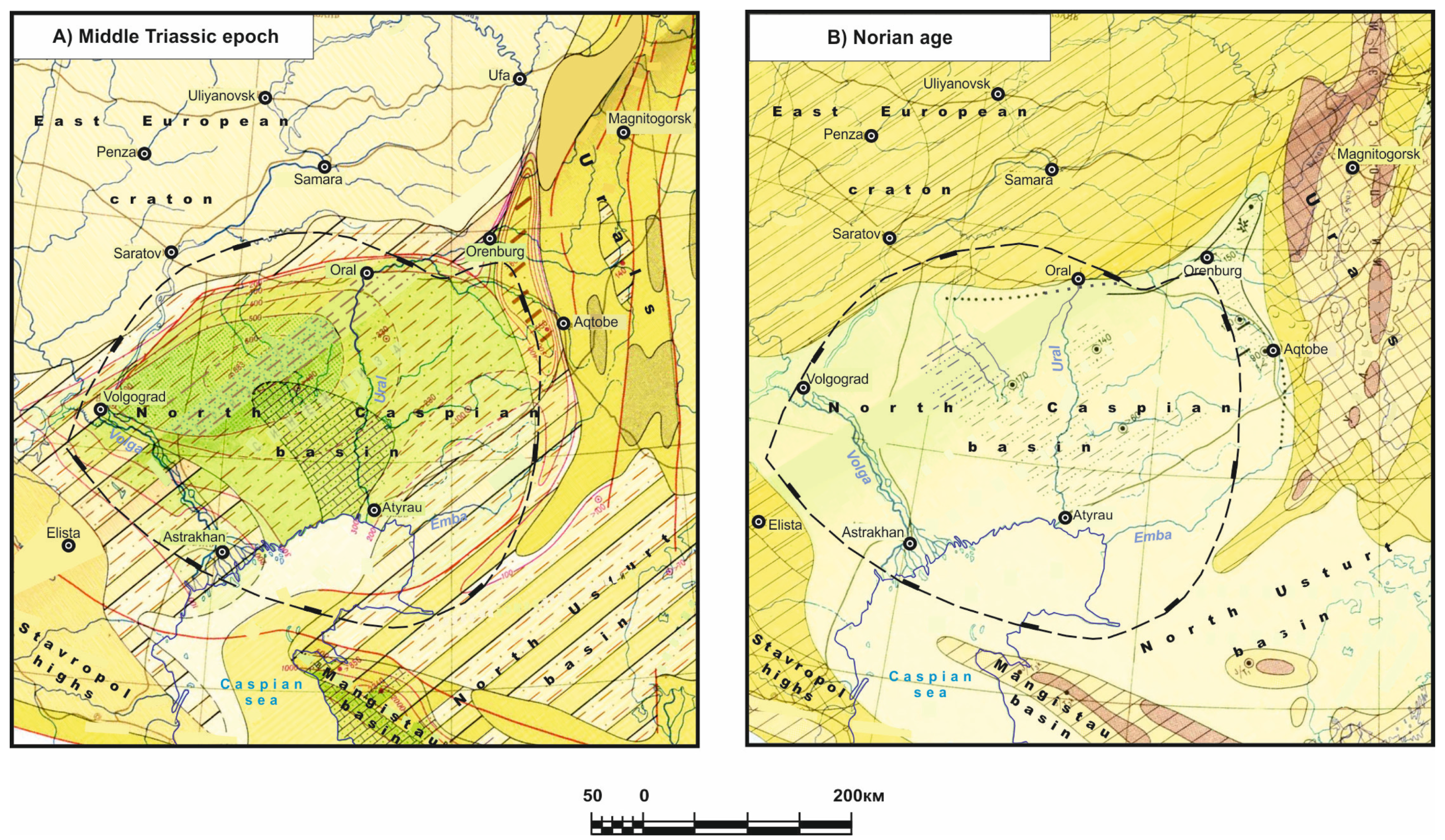
Middle Triassic epoch: In the Middle Triassic (
Figure 5A), as a result of the general uplift of the central and southwestern parts of the East European craton, a vast hilly plain was formed, and it was framed in the north by the Baltic and Timan uplifts and the Ural ridge of low mountains. In the south and southeast, it adjoined in the southwest with the coast of the Caucasus Sea, and in the north, it had a small outlet to the northern sea basin located within the Barents Sea.
In the lowlands, the accumulation of silts and clays predominated; however, during periods of swamping, masses of plant material from which coal deposits are formed predominated. River flows are often marked by banded cross-bedded sediments. In areas where marine water penetrated, pure quartz sediments were also formed. Middle Triassic deposits have not yet been identified in a number of places; therefore, the spatial position of the basins on the map is insufficiently accurate.
In the Middle Triassic, there was a regional uplift, as a result of which—at least by the Ladinian Age—the entire North Caspian Basin was elevated, and the accumulated sediments were washed away. The central part of the basin was apparently less elevated (and at the beginning of the era, it was even submerged), which resulted in the Lower Triassic and partially Middle Triassic marine sediments being most completely preserved within it. The Middle Triassic Sea in the North Caspian Basin was much wider, and carbonate silts accumulated within the region. The luxuriantly developing bivalves, ostracods, and charophytes resulted in the accumulation of thick shell limestones. The successive changes upwards along the section of coarse-grained, cross-bedded sands with charred plant remains and the remains of marine bivalves and clayey and clayey–calcareous silts testify to the gradual development of transgressions and the deepening of the basin from the beginning of the Anisian Age. However, the exclusively skeletal character of the limestones—interlayers of pelecypod shells and ostracod limestones—indicates that, during this time, the basin was not deep.
Late Triassic epoch—Carnian Age: The northern and central parts of the East European craton, as in the Middle Triassic, comprised a hilly plain. In the east, it merged with the vast Caspian lowland, which formed at the site of the sea that had retreated beyond the North Caspian Sea. The northern boundary of this sea in the Carnian age apparently did not extend beyond the Mangistau area.
Lake, alluvial, and deltaic formations with plant remains accumulated in the Caspian lowland. In the area of the North Caspian eastern border (Southern Emba high) at the beginning of the century, medium- and fine-grained sands—often clayey, with abundant, well-rounded, and angular-rounded small-sized and medium-sized pebbles comprising quartz, quartzite, other metamorphic rocks and quartz porphyry and siliceous rocks—accumulated, and they were carried away by river flows from the Southern Urals. In certain locations (on Makat and Kul-Sary), limestone pebbles were also deposited, and this was possibly due to the erosion of underlying Triassic deposits. Clays were deposited at times. Fish, ostracods, and bivalves lived in the basins. Horsetails grew along the banks of the reservoirs, and conifers grew on the adjacent slopes of the Ural Uplands. In the second half of the century, due to a decrease in relief in the areas of demolition and, apparently, a wider development of lakes, variegated clayey silts mainly accumulated, and sand and silts were only occasionally present.
The subsidence of the sea floor in the Mangistau region was obviously very intense. As a result, sedimentary and partly volcanic formations with a thickness of up to 1800 m accumulated. The intensification of the dolomitization process observed in the Carnian stage cross-section in the Mangistau region indicates the continual tendency of the basin to dry out. During the Carnian Age, on the eastern slope of the Urals, in connection with the renewal of block uplifts, low mountains appeared, as evidenced by the powerful basal strata of sandstones and conglomerates, and they were dissected by erosional–tectonic depressions.
Along the western sides of the basins, the sandy material of the alluvial–proluvial sand–conglomerate deposits exhibits a polymictic composition, indicating the erosion of a complex of Paleozoic rocks. The great thickness of these deposits indicates the increased dissection of the relief in the Carnian Age and the increased difference in the elevation marks of mountain structures and basins.
At the beginning of the Carnian Age, the formations of the Middle Triassic weathering crust were also washed away. As a result, a layer of variegated, poorly sorted sandy–clayey formations accumulated, the presence of which is characteristic of the Lower Carnian stage in the basins. Their gradual replacement upwards along the section by sandstones and conglomerates indicates an increase in tectonic movements and the involvement of the bedrock underlying the weathering crust in the sphere of erosion. In the marginal areas of intermontane basins, alluvial–proluvial sandy–conglomerate deposits usually form the entire subsequent part of the Carnian strata. In the central parts of the basins, where river valleys were gradually developed, fine-grained sediments were deposited. Small bodies of water inhabited by freshwater bivalves became swamped, and peatlands formed at the end of the century as tectonic movements weakened. The accumulated deposits, the thickness of which reached 450 m in some valleys, are characterized by the presence of layers of sideritized argillites and coal.
Norian Age: Within the East European craton and adjacent areas, the relief remained unchanged at the beginning of the Carnian Age. The accumulation of continental sediments also continued in the North Caspian lowlands. The deposition of sandy sediments with pebbles at the beginning of the Norian indicates a general uplift of the southwest of the East European craton at the beginning of the century. Significantly more intense positive movements were manifested at the end of the century; they caused a large regression in the southwest in Caucasian and in the south in Kopetdag and in the adjacent areas of Mangistau and Tuarkyr. As a result, the marine basin completely retreated from the areas of Mangistau, the southern part of the Caspian Sea, and possibly closed within the Greater Caucasus basin. It can be assumed that sedimentation occurred in Mangistau at the beginning of the century, although within a comparatively smaller area than before; moreover, repeated changes in geographical conditions possibly took place here.
In the North Usturt and Caspian lowlands (
Figure 5B), there was a coastal lake–alluvial plain and shallow marine water with abnormal salinity, within which variegated and gray-colored sandy–clayey deposits with layers of marl and dolomitic limestone accumulated. The East European craton retained the same features as the surface structure as in the Norian Age. It was an eroding and somewhat elevated plain. Only the Caspian were areas of sediment accumulation.
3.2. Jurassic Period
A new phase of development of the territory began in the Jurassic period. In comparison with the Triassic period, the land configuration changed significantly, and its relief became more contrasting. Transgressions and regressions occurred more often, and the sea areas increased. Movement in the folding areas became more intense. Areas with an accumulation of coal-bearing strata were formed, characteristic of the Jurassic period. In general, the Jurassic period is characterized by the acceleration of geological development processes—areas of land rose vigorously and faster than in the Triassic, a change in the environment occurred, and often, new large spaces became accumulation areas in a short period of time. The intensification of subsidence processes is confirmed by the significant thickness of accumulated sediments. Simultaneously, a tendency towards inheritance in the development of large regions is clearly evident; the main structures of the Triassic continued to develop in the Jurassic period.
A small sea bay jutted out in the southwest (Kuma–Manych trough). In the Hettangian age, a 20 m thick layer of dark gray layered clays formed here, and in the Sinemurian period, clayey sediments with sandy layers accumulated. The North Caspian Basin was occupied by a vast intercontinental accumulative Caspian lowland, where clayey sands with layers of pebbles, silts, and brown coals were deposited; the thicknesses ranged from 15 to 30 m. They were repeatedly washed away, and, as a result, were completely or partially destroyed in some locations. The maximum thickness of the Hettangian–Sinemurian sandy–pebble deposits in the South Emba region is about 30 m.
In the northwestern North Usturt region, the deposition of continental sediments that had begun during the Triassic period continued (but the rate of deposition had significantly decreased). In the Early Jurassic, there were no more than 500 m; in the rest of the Caspian Lowland, no more than 50–90 m was present. In the Gettangian and Sinemurian ages, in the southeast of the lowland areas, gray-colored, predominantly thin clay–silt—and less frequently sandy sediments up to 100 m thick—accumulated in shallow lakes and on alluvial plains.
Pliensbachian Age: In the Pliensbachian, the East European craton comprised gently rolling lowlands. The accumulation of terrigenous sediments continued only in the extreme south. Sandy–clayey material came from the surrounding uplands and was moved to the southeastern part of the territory. At the end of the century, the sea penetrated into the south depression. In the Kuma–Manych Depression, marine and coastal–marine sandy–silty sediments (50–80 m) apparently accumulated, with thin layers of coal and silty clays at the top. In the Caspian lowland, 15–30 m thick sandy–silty sediments with pebble–sandy bridges were deposited in swamps, lakes, and river valleys up to 90 m in the southeast. In some lakes, fine silts formed via the destruction of the weathering crust were probably deposited. In wide and gentle river valleys, sandy sediments with thin layers and lenses of coal accumulated in certain locations.
Toarcian Age: In the Toarcian, the paleogeographic situation on the East European craton did not undergo significant changes. Most of the platform was a low hilly plain subject to denudation, and in the south, sediments continued to accumulate. At the beginning of the century, the sea penetrated the southeastern part of the territory. Clayey–sandy sediments were deposited in the resulting shallow bay.
In the North Caspian Basin, the accumulation of lacustrine–marsh and alluvial sediments of sandy–silty compositions with thicknesses of up to 30 m continued over a vast territory. The North Caspian Basin in the Toarcian was a low-lying denudation plain, and in the east of it, in closed and semi-closed depressions, lakes and swamps were located. Clayey–sandy sediments of the upper part of the Chushkakul suite (90–130 m) were deposited here, and they were partially washed away at the end of the century. The area of erosion, as before, was the uplands of the Southern Urals.
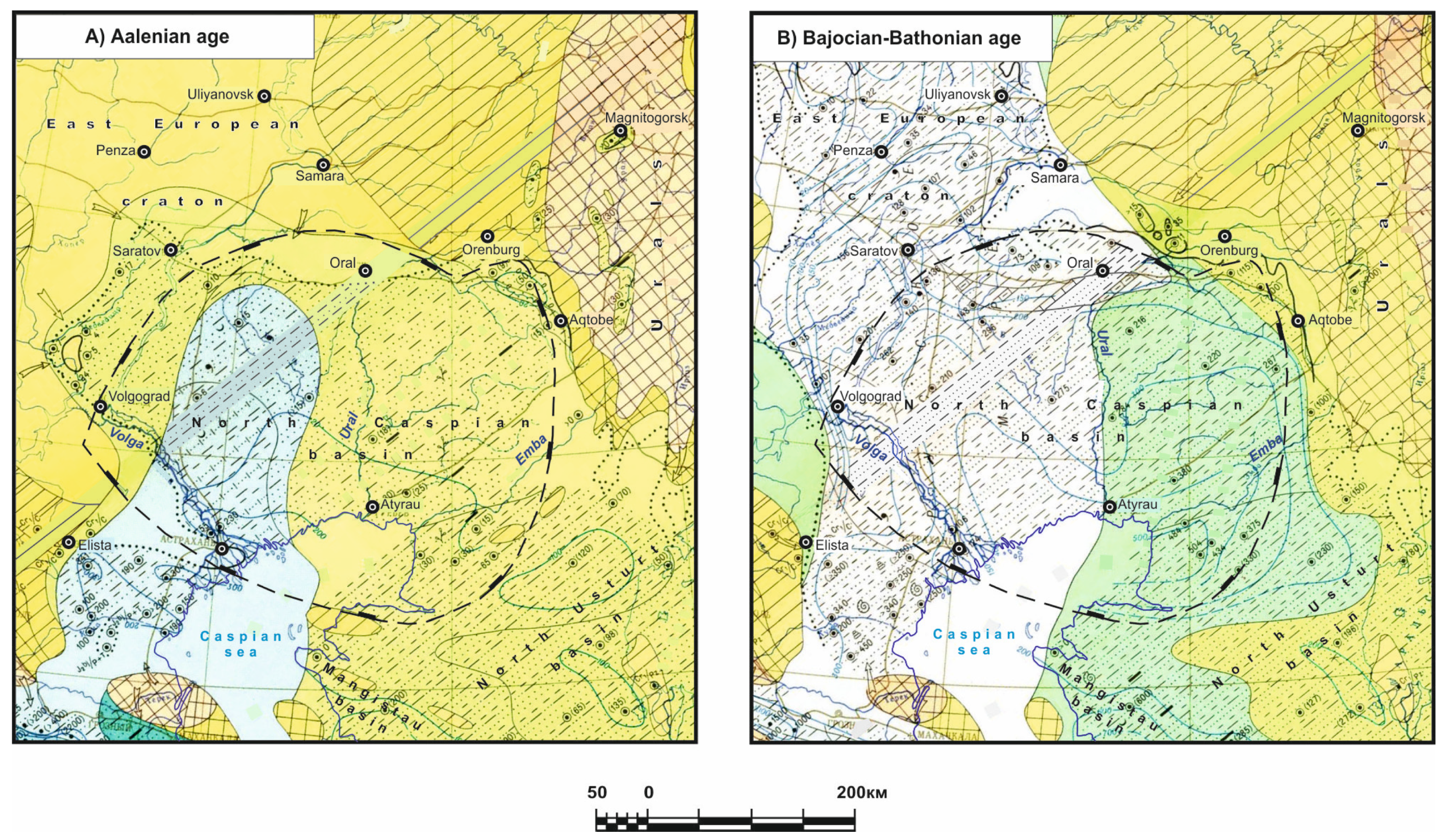
Middle Jurassic—Aalenian Age: In the Aalenian, the accumulation areas at the East European craton expanded somewhat, although most of the platform still represented a hilly denudation plain. The southwestern territories were separated from the North Caspian Basin via the Voronezh–Stavropol lowland denudation plain; in certain locations, it was hilly, and numerous rivers carried terrigenous material into adjacent basins (
Figure 6A).
The subsidence of the North Caspian Basin increased significantly, which resulted in transgression from the Pre-Caucasia region. The sea spread to the north. Silty clays with thin layers of sand and plant remains (more than 200 m) accumulated in the west of the Caspian Basin. The increase in the content of coarse-grained and medium-grained sand in sediments from the east to the west may indicate the influx of materials from Voronezh–Stavropol in the west. In the east, the sea was adjacent to a plain with a large number of freshwater lakes, swamps, and temporary streams, which periodically introduced sandy–silty material from the Ural Mountains and the islands of the South Emba Uplift. The total thickness of the sediments formed here reached 15–30 m. In the southeast of the Caspian lowland, in the environment of swampy lakes and alluvial plains, gray-colored sediments up to 120 m thick (lower parts of the Uzuntal suite) accumulated—carbonaceous clays and silts with sand interlayers and rare coal layers. Terrigenous materials mainly came from the low elevations of the Southern Urals.
In the territory of the Turan plate, the accumulation of alluvial, partially lacustrine silts, sands, and clays continued, and in swampy areas, coals and carbonaceous clays accumulated. The rhythmic alternation of the composition of rocks in the Tuarkyr cross-section indicates periodic erosion changes with respect to the general, gradual lowering of the base. River valleys at this time expanded, and watersheds decreased and leveled out.
In Mangistau, the angular Jurassic unconformity layer lies on top of the Triassic layer. The lower section includes the Kokaly FM of variegated clays and sandstones (40–100 m), with interlayers of carbonaceous shales and occasionally coal. The overlying Karadyirmen FM (up to 400 m) consists of alternating siltstones, siltstones, clays, sandstones, and coal beds. This suite corresponds to the Aalenian–Lower Bajocian. Sandstones with interlayers of clays and siltstones of the Bazarly FM (50–100 m) were present. Based on the remains of marine bivalves and ammonites, Parkinsonia parkinsoni Sow belongs to the Upper Bajocian–Lower Bathonian. The overlying Sarydyirmen FM is represented by alternating siltstones, clays, and sandstones with coal interlayers. The thickness of the suite varies greatly due to pre-Callovian erosion.
The Callovian includes sandy limestones, clays, and marls with ammonite shells, reaching a thickness of 112 m in South Mangistau. Oxfordian units are represented by marls and limestones, and they are only fully exposed in boreholes (thickness up to 110 m). Kimmeridgian is established only in boreholes in South Mangistau, where it is represented by siltstones, sandstones, marls, and limestones with a total thickness of up to 53 m. The Jurassic cross-section ends with a pack of marls and clays (10 m).
Bajocian and Bathonian Ages: On the East European craton, in the Late Bajocian and Bathonian ages, significant changes occurred. In the east of the Caspian region, marine deposits gradually passed into alluvial formations of the lowland plain (lower coal-bearing suite of the Southern Emba). In the southeast of the Caspian region and in the northwestern North Usturt region, lacustrine–bog and alluvial predominantly clayey sediments (100–230 m) were deposited, and they were carried down from the low hills of the Southern Urals.
In the Southern Urals and far to the east (Turgay plateau), the situation changed little in the Bajocian and Bathonian. Lake basins in depressions were often subject to swamping, which resulted in the formation of brown coal beds. The depressions were flooded with sediments up to 200–700 m thick.
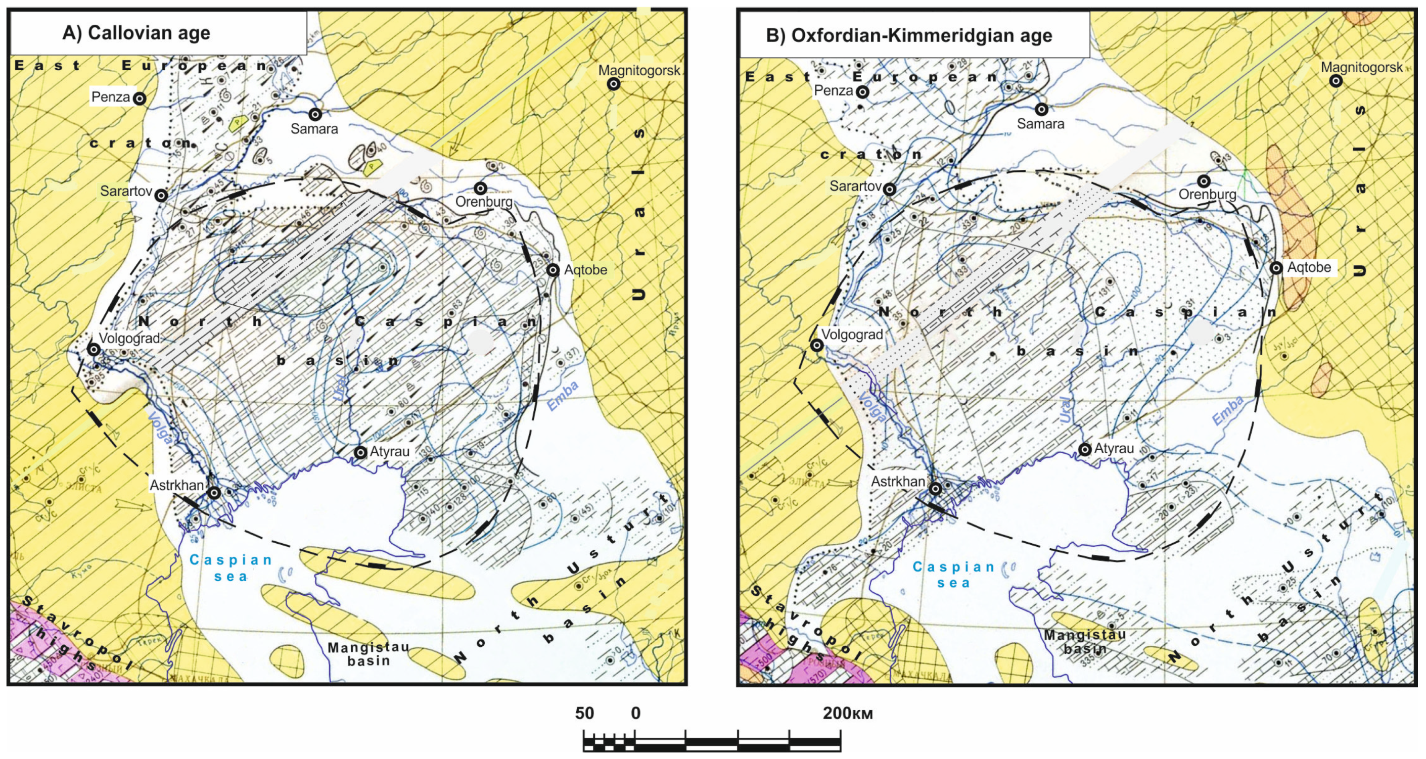
Callovian Age: At the beginning of the Callovian, the East European craton experienced a general subsidence. The Russian Sea expanded significantly; in the west and the east, it was framed by gentle elevations and plains.
Callovian sediments were transgressively present, and with erosion, they were also present in the Middle Jurassic and older formations; moreover, the sea captured a larger area. In the northwest of the North Caspian Basin, clays with an admixture of silt material were deposited in the sea (
Figure 7A). The carbonate content was noticeably reduced, and the composition of the biocenosis changed. Here, the depths were greater. The Turan plateau was flooded by a shallow sea in which terrigenous–carbonate sediments accumulated, and in the southeast, a layer of pure calcareous silts was formed from the Middle Callovian. The abundance and diversity of fauna indicate a favorable environment for its development—normal salinity and a gas regime of water, as well as the warmth of the basin.
Late Jurassic—Oxfordian and Kimmeridgian Ages: The paleogeographic situation on the East European craton changed little in the Oxfordian–Kimmeridgian: A large part of the platform was occupied by the shallow Russian Sea and framed in the west, south, and east by denuded hilly plains and elevations. However, in the Early Oxfordian, the sea somewhat expanded, reaching its maximum extent for the Jurassic, and beginning in the Late Oxfordian, especially in the Kimmeridgian, it began to shrink in size. In the Oxfordian, in the central regions of the Russian Sea, weakly calcareous and sometimes silty clays with rare nodules of phosphorite and glauconite with a total thickness of up to 10–12 m were deposited. In the coastal areas of the sea, thin-layered bituminous clays and clayey marls of thinner thicknesses accumulated.
In the Caspian region (
Figure 7B), the sea area decreased due to the increase in the Voronezh–Stavropol land to the east. In the coastal areas of the sea in the Middle Volga and Orenburg CisUrals areas, thin sandy and clayey limestones with glauconite and numerous faunas accumulated. The deepest part of the basin was located in the central segment of the Caspian Sea. Here, calcareous clayey–silty deposits of thin thicknesses were formed. In the southern part of the Caspian Sea, there was a shallow area where calcareous and silty glymns accumulated. In the southwest, the North Caspian Basin, through the Manych Strait, connected with the Caucasus Sea. In the Oxfordian and Kimmeridgian, in the southeast of the Caspian Sea, there was a shallow sea bay with flat islands. The bay accumulated clay, silt, and sand in locations with clayey limestones (10–20 m) and shell rock deposits, and it was inhabited by foraminifera and bivalves.
Carbonate sedimentation in the shallow sea of the Turan Plateau is characteristic of the Oxfordian Age. From the land adjacent to the east, as well as from a few islands, among which the largest was Karabogaz, very little terrigenous material entered the basin, which indicates significant peneplopization of the land. Simultaneously, the composition of the marine fauna indicates a wide connection of the Turan Basin with the Russian Sea and Tethys.
Islands appeared within the Karatau Mountain (Mangistasu area), and the Tuarkyr region apparently dried up. Lagoons formed in shallow areas of the sea. A particularly large lagoon basin arose in the southeast of the Turan Plate; direct connection with the open sea ceased, and any connection with it occurred through the shallow, temporarily saline eastern part of the Kopetdag Sea.
Titonian Age: In the Titonian Age, the marine environments in the East European craton further contracted. The sea area did not decrease only at the center of the Caspian Lowland. Here, marls, sandy silts, and silty limestones were deposited in the sea; ammonites, belemnites, rhynchonella, etc., lived in this area. In the southern and southeastern parts of the sea, in the area of the South Emba Uplift, red-colored deposits accumulated, alternating with normal marine deposits. In the North Usturt region (Aral Sea area), there was also a shallow sea in which clays and silts up to 45 m thick were deposited. Terrigenous material came from the Southern Urals and Central Asia. During the Late Titonian, the Russian Sea shrank even more. Siltstones, limestones, and silty sandstones accumulated in the northwestern and western parts of the Caspian Sea at the same time.
Changes took place far in the south (Kopetdag Sea). In the east and along the northern edge of the sea, the zone of lagoon basins expanded, and the formation of red continental sediments began. Even in the inland areas of the sea, such as in Central Kopetdag, layers of gypsum and anhydrite appeared among the limestones of the upper part of the Jurassic, indicating a sporadic uplift of areas with increased salinity. In the Titonian, almost the entire Turan plateau turned into dry land as a result of the continued uplift. Here, low-lying, weakly eroded plains were present, and sedimentation did not occur in any noticeable quantities. The latter took place only in the southeast and in the north but under different conditions. In the Titonian, the previous situation was preserved in the Southern Urals and to the east in Turgai. In rare lakes among vast plains, variegated clay-silt sediments of insignificant thicknesses accumulated.
3.3. Cretaceous Period
Berriasian and Valanginian Ages: At the end of the Jurassic, the Russian Sea sharply contracted and became shallower, and its connections with the Boreal Arctic Sea basins were apparently interrupted, but in the most depressed areas of the platform, no significant changes occurred. One regression was short-lived and was soon replaced by a transgression. The Caucasian Sea spread far to the north, again capturing the abrasion plains. As a result, Berriasian deposits were present on various Jurassic, Carboniferous, and Devonian horizons, and in the Voronezh anteclise, they were present on the Precambrian horizon. In the southeast, the Russian Sea adjoined the Ural Upland, where the greatest depths were and where it connected with the Caucasian and Kopetdag Seas. From here, far to the north and into the Russian Sea, representatives of the fauna of the southern seas were present in the area: trigonids and some species of ammonoids. In the east, the sea bordered the Ural Upland and the Ural Lowland, and in the west, it bordered the Baltic Highlands. In short periods of time, through narrow straits, the Russian Sea was connected with the seas of Western Europe.
In the central part of the Russian Sea, in the Berriasian, glauconite sands with phosphorite concretions accumulated, and this is possibly due to the washing of Jurassic phosphorites. Then, shell rock formed from broken shells of buchias, also with phosphorite. In the Late Valanginian, regression took place, and the connections of the Russian Sea with the northern and southern seas were repeatedly interrupted. However, in the central part, as before, marine shallow-water glauconite sands with phosphorite and numerous phosphatized shells of ammonites accumulated.
In the southeast of the Russian Sea (in the Caspian region), clays with sand interlayers, pebbles, and oolites of brown ironstone initially accumulated; then (in the Sol-Iletsk region), valleys with phosphatized concretions formed. In the east, sand was predominantly deposited. In the south, in the distribution area of salt domes, which were local zones of uplifts, the concretions of phosphorites were concentrated. Near the modern Orenburg Cis-Urals, coastal cross-bedded sands accumulated over a wide area. The abundance of buchia and ammonite shells indicates the rich organic life of the sea at that time and, accordingly, its normal salinity and the good aeration of the water. Although representatives of the fauna of the southern seas were present in the north, the difference in the mollusks inhabiting the sea in the north and south is very significant, which indicates their different biogeographical region origins.
To the east of the Russian Sea, there was a large, meridionally elongated, slightly elevated plain dividing the Russian and West Siberian seas in the east. Based on the sediments accumulated in the neighboring seas and the continental deposits preserved from erosion, it can be judged that in the axial part of the plain, there were relatively low hills from which rivers and streams flowed with wide floodplain valleys abundant with lakes. Here, weathering crusts were formed, and in the depressions, lacustrine–alluvial sands and clay accumulated. In the Turgai Lowland, these deposits reached a thickness of 10–15 m. The sands were mainly polymictic, and the clays comprised montmorillonite, hydromica, and kaolinite; the spores of moisture-loving and heat-loving ferns and ginkgo plants were found in them. The vast epicontinental West Siberian Sea was located to the east of the Urals.
To the south was the Kopetdag Sea with adjoining accumulative continental plains and lagoons to the north. To the east was a lowland plain and a mountainous region dissected by narrow accumulative alluvial valleys. The significant aridization of the climate compared to the Jurassic period caused the accumulation of not only red continental and lagoon deposits in the east of Central Asia but also primary dolomites and gypsum in the Kopetdag Sea. The development of transgression in the Berriasian and Valanginian was replaced by regression at the end of the Valanginian and at the beginning of the Hauterivian. In the extreme east, as a result of short-term but significant uplifts in isolated depressions, relatively thick packs of coarse clastic continental sediments were formed.
Hauterivian Age: On the East European craton, despite the general regression at the end of the Valanginian Age, the size of the marine environments only decreased slightly, and in some places, the sea captured new adjacent lowland spaces. In a number of areas, the sea became deeper, and the subsidence of the bottom accelerated, compensated by accumulating sediments. In the central parts of the sea, the rate of sedimentation was obviously greater than in the Valanginian as a much thicker layer accumulated in a shorter time period. The lowlands adjacent to the Russian Sea comprised far in the west, and the Ural in the east changed little, but in the southwest, and its northern and southern margins turned from denudation into continental accumulative plains. As was the case previously, the margin of the Russian Sea was located in the southeast of the platform. Its eastern shore at certain periods of time approached the region of the modern eastern edge of the Caspian Sea, but sometime again, it moved to the east, right up to the North Usturt region.
In the Early Hauterivian, the size of the Russian Sea decreased. In the area of the modern Middle and Upper Volga region, quartz–glauconite sands and silty clays with concretions of sandy phosphorite, in which ammonite shells were buried, accumulated. In the second half of the Hauterivian, the sea advanced from the southeast through the Caspian regions (
Figure 8A).
In many places, Valanginian deposits were washed away, and on the outskirts of the sea, Late Jurassic deposits were present. In the area of the Mangistau trough, near the western coast, fine-grained sands accumulated as a result of the action of sea currents, and clayey–silty particles were carried beyond this zone. In other places, clays were deposited over most of the Russian Sea. In the southeast of the North Caspian depression, there was an open deep-sea basin. It was widely connected with the southern and northern seas. At the beginning of the century, silty and calcareous sands with layers of clays containing glauconite accumulated here, and later, clays with layers of silt and sand also accumulated. In the area of Southern Emba, marine clay sediments were mainly deposited. At the end of the century, the composition of the sediments did not change, but the desalination of the basin apparently took place. The total thickness of the sediments here exceeded 100 m. Terrigenous material entered this basin from the Aqtobe and the Orenburg Urals. Far in the west, freshwater continental sediments accumulated on a vast lowland plain. By the end of the Cretaceous, the sea had shrunk, paleogeographic conditions had changed dramatically, and the mass extinction of ammonites had occurred, but other representatives of the fauna that had existed in a normally salty marine environment had also settled.
Barremian Age: At the boundary of the Hauterivian and Barremian, no significant changes occurred in the location and outlines of the land and sea at the East European craton, as there are no visible signs of a break in sedimentation. However, the paleogeographic environment has undergone a significant evolution. The mineralogical characteristics of the terrigenous part of the sediments change sharply, which indicates changes in the areas of denudation and in the composition of the marine fauna: Many genera and species of ammonites disappeared and, to the contrary, belemnites, scaphopods, pelecypods—inhabitants of the sea basin with a normal salt and gas regime—experienced lush development. The Ural Upland, especially in the north, somewhat decreased, and the central part of the Russian Sea became even shallower, although the hydrochemical regime here did not change. The rate of subsidence at the bottom of the Russian Sea decreased, the thickness of the sediments became even thinner, and the composition of the sediments became coarser.
In the southeast of the platform in the Caspian region, the sea shrank and freshwater sediments accumulated in the vacated areas, but at times, the sea flooded the coastal lowland. A layer (up to 386 m) of variegated clays, silts, sand, and marl formed here. In the south (South Emba), sand particles up to 30 m thick lie under the variegated layer, and they erode over more ancient formations. Conglomerates lie above the variegated layer in some places, and then alternating packs of sand, silt, and clay with interlayers of limestone and marl were present. In the west of the North Caspian Basin, there was a sea in which clay materials with interlayers of sand were deposited.
In the Early Barremian, the Kopetdag Sea continued to widen and deepen in the Kopetdag and Bolshoy Balkhan region (south area). In the south, in the Kopetdag region, carbonate sediments were deposited, and at the end of the Barremian, marls were deposited as well. The subsidence of these areas was significant. Simultaneously, about 100 m of clays and silts had accumulated here.
The adjacent areas of the southeast of the Ural Upland also underwent significant evolution. Here, separate small hilly uplands were formed, which were divided by wide lowlands. The significantly expanded coastal lowlands in the southeast, within which continental sediments accumulated, almost merged with the accumulation area of the Turgai Lowland to the east from the Urals.
Aptian Age: Physical and geographical conditions changed significantly in the Aptian over most of the East European craton, but the changes occurred gradually (
Figure 8B). As was the case everywhere, Aptian deposits lie conformably and without interruption on Barremian deposits. The difference in the mineral composition of the sediments indicates a change in the conditions of the denudation areas. At the beginning of the Aptian, the sea somewhat expanded. In the southeast, the Russian Sea merged with the Kopetdag and Caucasian seas.
Further south, in a vast, calm, well-warmed epicontinental sea with depths that hardly exceeded 100 m, planktonic organisms, as well as bottom fauna and flora, widely developed. Mainly fine terrigenous material entered the sedimentation basin. As a result, over vast areas in the west to the modern Volga in the east and the south and from the latitude of modern Saratov and the north of the Caspian Sea—a thick layer of bituminous shales and clay sediments with interlayers of siltstones and numerous remains of ammonites and pelecypods accumulated. Later, thin (1.5–2.0 m) characteristic limestones and marls (Aptian plate) were deposited over the entire area of the Russian Sea.
In the Late Aptian, the Russian Sea retreated to the south, and apparently, its coastal line was located near modern Ulyanovsk. Simultaneously, clays with lenses and interlayers of siltstone with concretions of calcareous sandstone (about 40 m thick) and the remains of ammonites and aucellines accumulated here. In the southeast of the East European craton, at the beginning of the Aptian, marine sands and clays were deposited in the north of the North Caspian depression (
Figure 9B).
These deposits apparently formed in the surf zone and intense waves, and they formed a strip up to 70 km wide. To the south of it, silty and bituminous clays, as well as limestones and marls, accumulated; to the south, clays with interlayers of siltstone and marl accumulated. In the area of South Emba, conglomerates, sand, silt, and clay up to 30 m thick initially accumulated, and later, black clay with numerous ammonite remains was present. The thickness of the Lower Aptian deposits in South Emba is up to 70 m. In the Late Aptian, clayey silt and sand with clay interlayers (up to 107 m thick) and the remains of ammonites, aucellinae, and foraminifers were deposited here. In the southwest, in the area of the Kuma–Manych, similar sediments with numerous ammonites and serpulids shells were formed. By the end of the Aptian, a significant part of the platform was raised, and the sea retreated to the southeast. At this time, the northern and western parts of the platform became a gently rolling denudation plain.
In the Aptian, the transgression was even more widespread. The Kopetdag and Russian seas merged, and by the end of the century, the sea moved far to the east far into the regions of southeastern Turkmenistan. At the beginning of the century, carbonate and clay–carbonate sediments continued to accumulate in the south, and clastic deposits were present in the western region. Later, but still in the Early Aptian, the predominant type of sediments was sand, silt, and mud. In the east of Central Asia, as in the Barremian, there was a vast lagoon within which gypsum, red sand, and clay were deposited. Red continental sediments were deposited in the coastal areas in the east of Central Asia. Judging by the numerous remains of ammonites, the Kopetdag Sea was connected to warm seas and was part of the Mediterranean biogeographic region. In a number of places, in the Aptian deposits, numerous thick-walled oyster shells, as well as shells of large foraminifers, were found, indicating the comparative shallowness of the sea.
During the Aptian, further leveling and merging with the Kazylkum Lowland and the lowland of the southeast of the East European craton, as well as an expansion of the lowland in the north, took place in the Turgai plateau. Simultaneously, a single large accumulative plain was formed, within which lake, swamp, and river sediments were deposited. On the eastern edge of the lowland, river sand, and pebble sediments were deposited, which apparently formed in connection with small uplifts and elevations. The rate of subsidence of the accumulation surface in the Turgai Lowland was insignificant since the thickness of the Aptian deposits only reached 50–75 m in some locations.
Albian Age: During the Albian, significant changes in the geographic conditions occurred. By the middle of the century, the sea had captured large areas in the central and southern parts of the platform, but in the north, the transgression extended only north of the modern Arctic coast. Separately, and likely for short-term periods of time, a connection was established between the southern and northern seas through the strait connecting the Russian Sea. The Ural Uplands became even more leveled, comprising elevated hills separated by denudation plains only in certain locations. The vast western lowland was flooded by the Russian Sea, which was connected with the European seas. In the south of the platform, the connections between the Russian and Caucasian seas became even wider; in the southeast, the Russian Sea connected with the Kopetdag Sea, which formed a large shallow water area. At the beginning of the Albian, in the area of South Emba and to the northwest, marine sand (up to 10–15 m) with phosphorite nodules and a conglomerate of sedimentary and igneous pebbles accumulated; then, calcareous clays also accumulated.
The maximum thickness of the deposits is about 90 m. In the area of the Mangistau trough, quartz and feldspar sands with glauconite up to 100 m thick were deposited. Such deposits accumulated further north, as far as Saratov and possibly even further north, but they were later washed away. To the southwest of the North Caspian Basin, in the areas of the Kuma–Manych trough, glauconite sand particles up to 164 m thick were deposited. A significant expansion of the sea areas began in the Middle Albian. At this time, the sea spread north of Saratov. Sands and clays accumulated within the Russian Sea, and in the coastal areas, phosphatized siltstones with a P2O5 content of up to 8% and with ferruginous oolites were present.
In the southeast of the platform, within the North Caspian depression, the sea depths were comparatively large in the Middle Albian. In the Mangistsau trough, sand particles with clayey–silty interlayers that were partly phosphatized, with a thickness of more than 100 m, were deposited. In the north of this part of the sea basin, clays with thin interlayers of silt and sand (up to 45 m thick) and the remains of ammonites, inoceramus, and aucellinae accumulated in shallow water conditions. In the Late Albian, deep-water clays with interlayers of sand and silt with remains of foraminifera (with a total thickness of up to 105 m) accumulated in the Mangistsau trough. Simultaneously, to the west, within the Scythian platform, there was a deep strait connecting the Russian and Caucasian seas. In the strait, clays with interlayers of sand and siltstones with a thickness of 14 to 105 m were deposited and later partially washed away.
The coastline of the sea was located in South Emba, to the east of which there was a coastal plain where continental sediments accumulated, and this area was sometimes flooded by the sea. To the east, in the Late Albian, there was a vast alluvial plain. In the sediments that accumulated here, the leaves of plane trees and other plants were found, indicating a warm and humid climate. To the east and southeast of Aqtobe, these deposits lie on Paleozoic formations; they comprise cross-bedded sand with clay interlayers and, in certain locations, conglomerates. At the very end of the Albian, the northern and southeastern parts of the platform apparently experienced a general uplift, and the connection between the northern and southern seas temporarily ceased.
In the Albian, the outlines of the Jurassic basin in Central Asia changed little, but at times, the sea penetrated even further to the southeast and flooded the coastal alluvial plains. The predominant type of marine sediments comprised terrigenous deposits with only a small admixture of carbonates. Similarly to previous time periods, the sedimentation basin experienced the greatest subsidence in the south in the Kopetdag region. However, in the north, in the Mangistau region, very thick sandy–silty sediment strata were also formed. At the beginning of the Albian, clays mainly accumulated; later, sands and silts began to play a significant role. Shelly detrital limestones and shell rocks were formed in the Middle and Late Albian, especially in the east of the Kopetdag Sea. The deepening and widening of the sea determined the wide distribution of ammonites here, and oysters and other bivalves were only present in shallow waters.
Late Cretaceous—Cenomanian Age: The general wave of subsidence, which began at the end of the Albian, entailed a transgression of the sea from the south (
Figure 9A).
The sea covered a huge area of the platform, but mostly, it was shallow with rapidly changing currents with respect to strength and direction. In the south, there were large islands from which detrital material was supplied. Likewise, from the north and central parts of the platform, which was a vast lowland area, detrital material was supplied to the sea in abundance. At this time, various sands were deposited, and they often included glauconite, with phosphorite concretions and pebbles. In the area of the Voronezh anteclise, Lower Carboniferous rocks predominate in the composition of pebbles. In the southeast of the platform and along the periphery of the Ukrainian Shield, continental sands and clays with plant remains accumulated in small areas. In the Cenomanian, the Russian Sea was widely connected to the Caucasus in the south, to the Kopetdag in the east, and to the seas of Western Europe in the west. In this area, as was the case previously, in the Cenomanian, there was a large sea basin—the Caucasus Sea—which was part of the deep-water basin region. This sea had wide connections with the Russian and Kopetdag seas, as well as with other seas of the Mediterranean belt (Tethys). In the north of the Caucasus and in the transitional area from the platform to the geosyncline, mainly sandy clay sediments and, in smaller quantities, terrigenous–carbonate deposits were deposited in the Cenomanian. By the beginning of the Late Cretaceous, within the limits of the greater part of Central Asia, there was a vast sea basin—the Kopetdag Sea. Along the margins of the Kopetdag Sea—of which the sediments were sometimes flooded by this sea—terrigenous and coarse-grained deposits were deposited, sometimes at a very significant distance from the shore.
Turonian Age: In the Turonian, especially in its second half, there was a further expansion of the Russian Sea. In the Ulyanovsk region, where the Cenomanian is absent, the occurrence of Upper Turonian white coarse chalk on the ancient Mesozoic has been established. In a number of places, a break in the deposits between the Cenomanian and Turonian is clearly established: for example, in the Caspian region (
Figure 9B), in the north of the Black Sea basin, and so on.
Over most of the sea, white coarse chalk and chalk-like marls were deposited, and they were often sandy with a large number of inoceram shell fragments. These sediments accumulated in shallow waters where the action of waves and currents was felt, as a result of which horizons of ferruginous and compacted limestones and chalk were formed. Limestones and chalk were deposited at great depths, and sands and clays were deposited in the coastal zones. Opoka and tripoli were formed in the northeast. The presence of bentonite layers among the sediments indicates the introduction of volcanic ash into the sea.
In the Turonian, the situation changes significantly. The Kopetdag Sea covers wider areas in the east than in the Cenomanian. The sizes and heights of the continental massifs are reduced. The areas of lowlands and plains—within which alluvial and foothill formations had previously accumulated—and sometimes lagoonal areas are also reduced. In the west of the Kopetdag Sea, calcareous and calcareous–clayey sediments begin to accumulate; however, over most of the seabed, essentially clayey sediments continue to form, and in the coastal zone, sandy sediments continue to form. In the east of the Kopetdag Sea, clayey and carbonate sediments were deposited in the Early Turonian, and terrigenous fine-grained sediments were deposited in the Late Turonian.
In the Turonian, the sea bays in the south and especially in the north of Turgai expanded; at times, they likely turned into straits connecting the West Siberian and Kopatdag seas. Sandy–clayey sediments accumulated in the bays. Thick and extensive deposits of oolite iron ores formed in the lagoons and in the valleys of the rivers flowing into them. Humus clays interbedded with glauconite–quartz sands accumulated in a number of lagoons. The high content of pyrite, unoxidized humus in the sediments of the central parts of the lagoons indicates that there was a disturbance in the gas regime of the waters here.
Coniacian Age: On the East European craton, the environment in the Coniacian Age was close to the environment of the Turonian period, but the size of the basin somewhat decreased, especially with respect to the margins of syneclises and anteclises.
In the Coniacian Age, no significant changes occurred within the Caucasian Sea and adjacent areas compared to the Turonian Age. In Central Asia, in the Coniacian Age, the paleogeographic environment changed only slightly compared to the Turonian Age. The Kopetdag Sea expanded somewhat to the northeast and east. Within its boundaries, in the west, over an even larger area than before, carbonate sediments accumulated, and in the central part, calcareous clays accumulated. In the Coniacian Age, the sea expanded in the north of Turgay. In the south, the sea apparently penetrated far into the north of the Turgay trough only in isolated periods of time. In the middle part of the trough, freshwater and continental sandy–clayey sediments accumulated. Sandy–clayey sediments were also deposited on the seabed. Deciduous subtropical forests mainly grew along the seashores.
Santonian Age: The beginning of the Santonian is characterized by some expansion of the Russian Sea. In the Caspian region, the Santonian “sponge” layer transgressively overlaps various horizons of the Upper Cretaceous. The comparatively rapid and significant subsidence of the eastern edge of the platform confirms the spread of the sea to the east. In the west of the Southern Cis-Urals, the base of the Santonian, composed of conglomerates, lies not on Coniacian deposits but on Paleozoic deposits. In the Santonian, in the west of the North Caspian depression, siliceous sediments formed, consisting of the skeletons of diatoms and radiolarians. This is probably associated with cold currents that penetrated far into the south. These can also explain the penetration of the northern representatives of the marine fauna to the south. In the central and western parts of the Russian Sea, carbonate and clay–carbonate deposits mainly accumulated in the Santonian. In the Santonian, the water area of the Kopetdag Sea decreased. The coastline moved significantly to the west. More terrigenous material began to flow into the sea. At this time, marls and clayey limestones accumulated in the west of the Kopetdag Sea, and in the east, as was the case previously, sandy and clayey sediments accumulated only in the south of Turkmenistan. In the Santonian, the paleogeographic situation in Turgai changed little compared to the previous period.
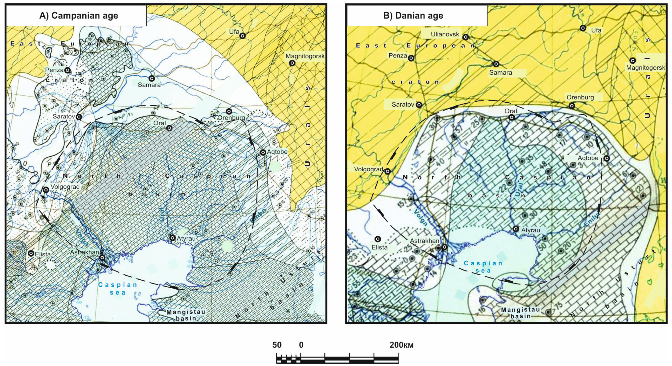
Campanian Age: In the Campanian period, the Russian Sea noticeably shrunk. This is clearly observed in the northern area and in the east of the platform, where the direct connection of the boreal and southern seas probably ceased. However, in other parts, the situation remained the same. Only in the east of the Voronezh anteclise, judging by the nature of the sediments (accumulation of sandy material), did the sea further become shallow (
Figure 10A). In the Campanian, Central Asia changed again. The Kopetdag Sea transgressed to the east; in the south, existing lagoons experienced a wider connection with the open sea. The distribution area of terrigenous material somewhat decreased. In Mangistau and the southeast, purer carbonate sediments accumulated, but in the southwest and northwest, as was the case previously, mainly marls and clayey limestones were formed. In the east, in Southern Turkmenistan, purely carbonate sediments were deposited over a large area; in the Kyzylkum, as was the case previously, sandy and, to a lesser extent, clayey sediments were present. In the Campanian period, the sea bays in the Turgai trough expanded significantly, and by the end of the century, apparently, a connection between the northern and southern seas was formed. At this time, sandy–clayey sediments accumulated in the south and marls in the north as well.
Maastrichtian Age: In the first half of the Maastrichtian, the Russian Sea experienced some expansion, and similarly to previous periods, carbonate rocks mainly accumulated—white chalk and also clay–carbonate deposits to the east of the Voronezh Shield. However, the size of the sea area was gradually reduced; the single basin began to disintegrate into a multitude of basins that connected with the Caucasus Sea in the west and with the Kopetdag Sea in the east. In the second half of the century, the role of terrigenous sediments—sandy chalk and sand—became greater. At the beginning of the Late Maastrichtian, the sea left the Dnieper–Donets syneclise. In the Maastrichtian, the Kopetdag Sea expanded even more. In its significant western part, carbonate sediments mainly accumulated. In the central and southeast parts, carbonate and terrigenous sediments were formed.


 ,
, 


