


Inventory and Quantitative Assessment of Coastal Geoheritage: Contribution to the Proposal of an Active Geomorphosite


Abstract
1. Introduction
- Geosites (i.e., only sites established pursuant to I.D. 87/2012);
- Sites of geological interest (i.e., sites of recognized scientific interest that would be progressively established);
- Sites of attention (sites whose information, rarity, and representativeness needed to be confirmed by scientific investigation so that they could be subsequently included among the sites of geological interest).
2. Materials and Methods
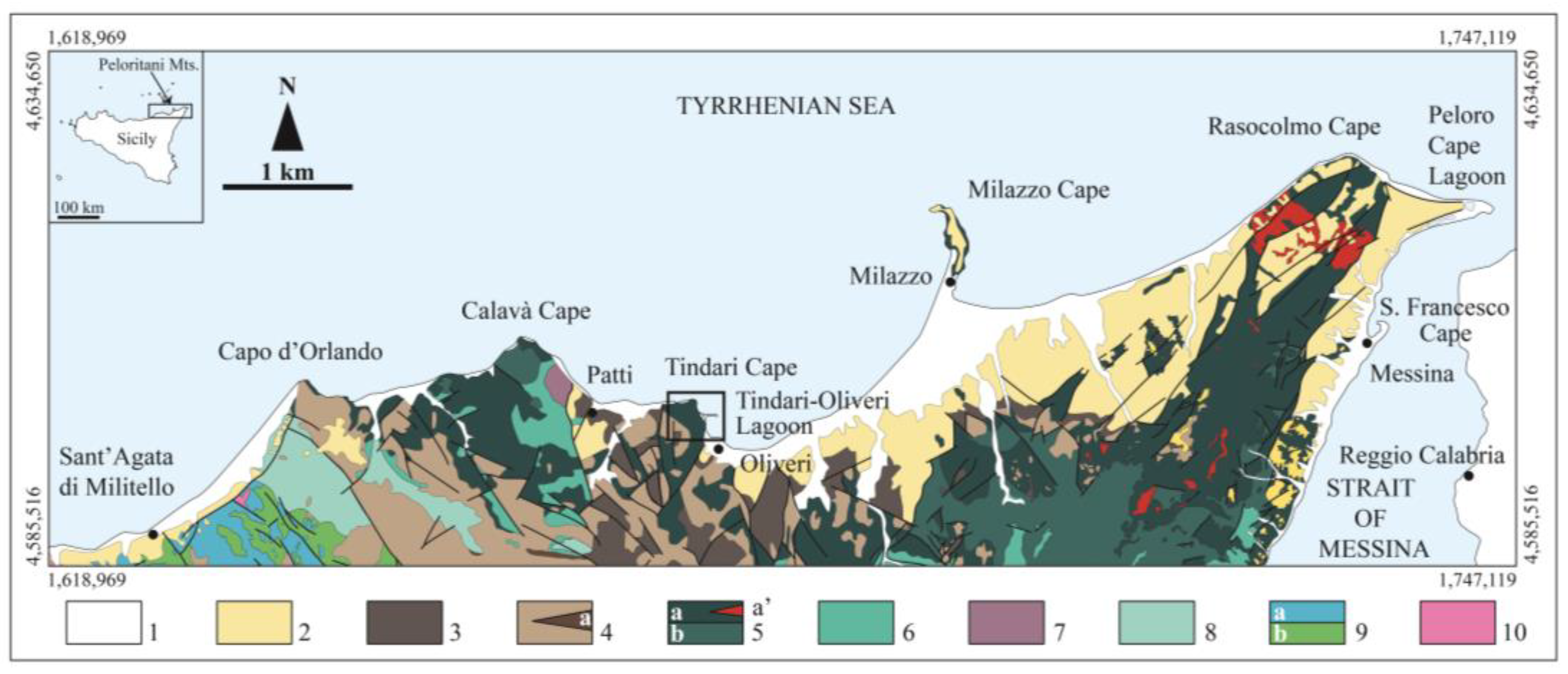
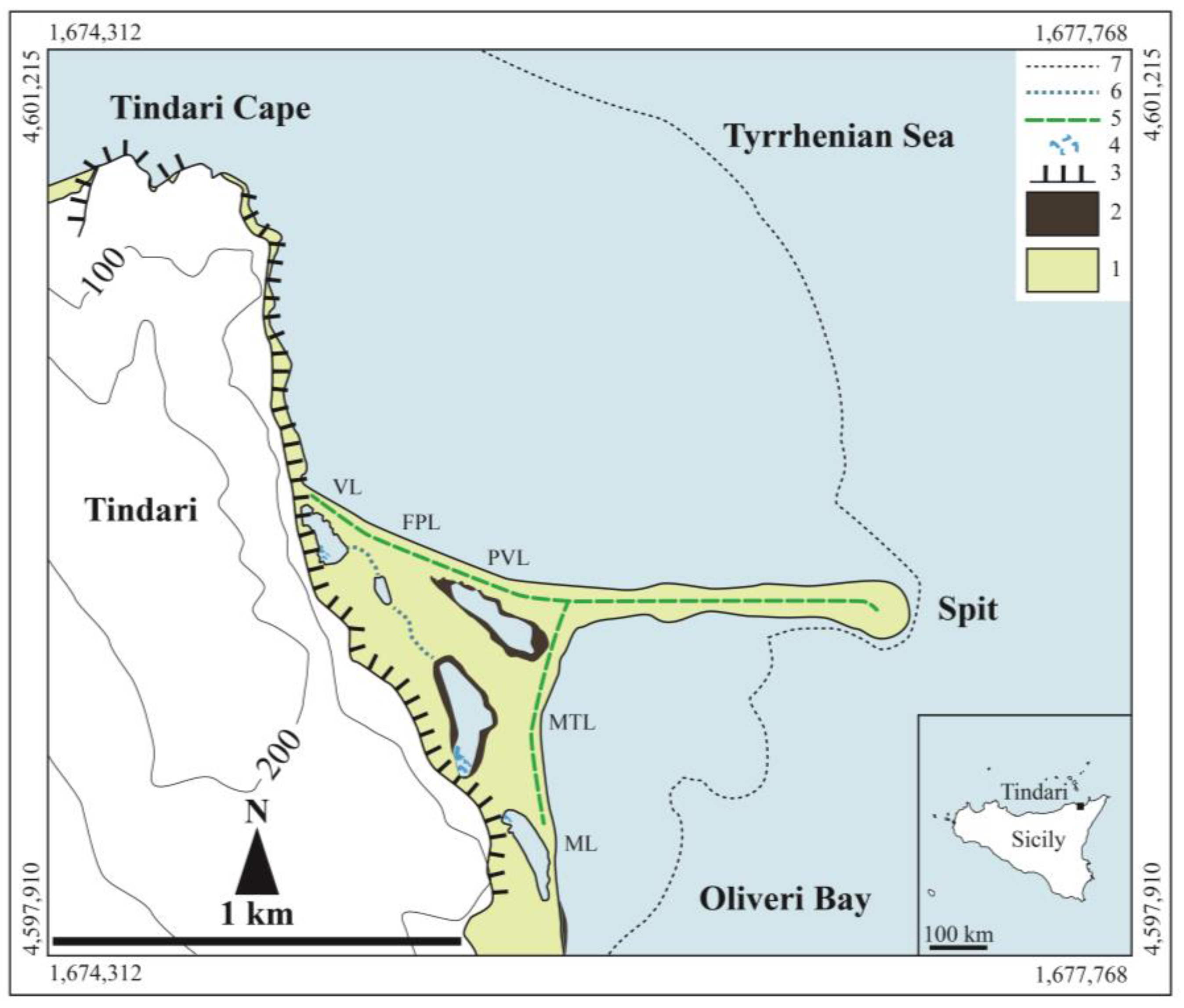
2.1. Study Area and Geological Background
2.2. Particle Size Analysis and Textural Parameters
2.3. Petrographic Analysis
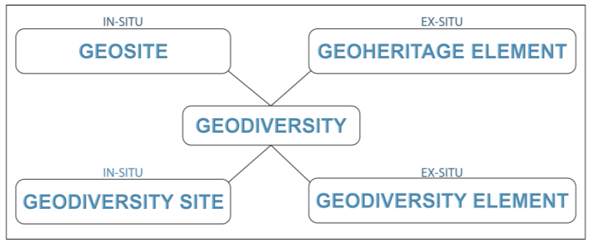
2.4. Brilha Method for the Inventorying and Quantitative Assessment of Geodiversity
3. Results
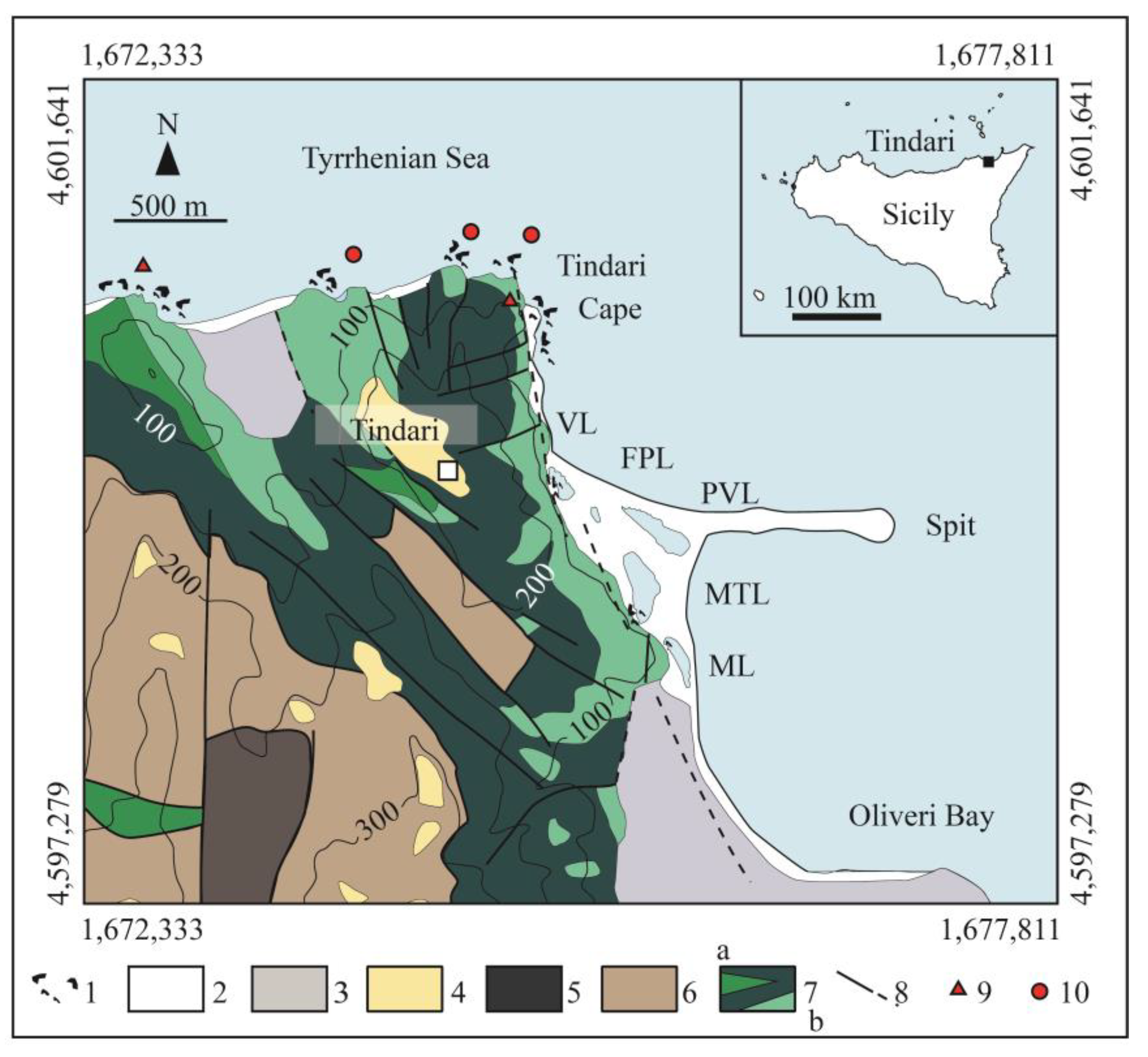
3.1. The Geoheritage of the Oliveri–Tindari Lagoon and Spit
- Verde Lake (VL, areal extension: 7039 m2);
- Porto Vecchio Lake (PVL, areal extension: 23,490 m2);
- Mergolo della Tonnara Lake (MTL, areal extension: 26,645 m2);
- Marinello Lake (ML, areal extension: 26,780 m2).
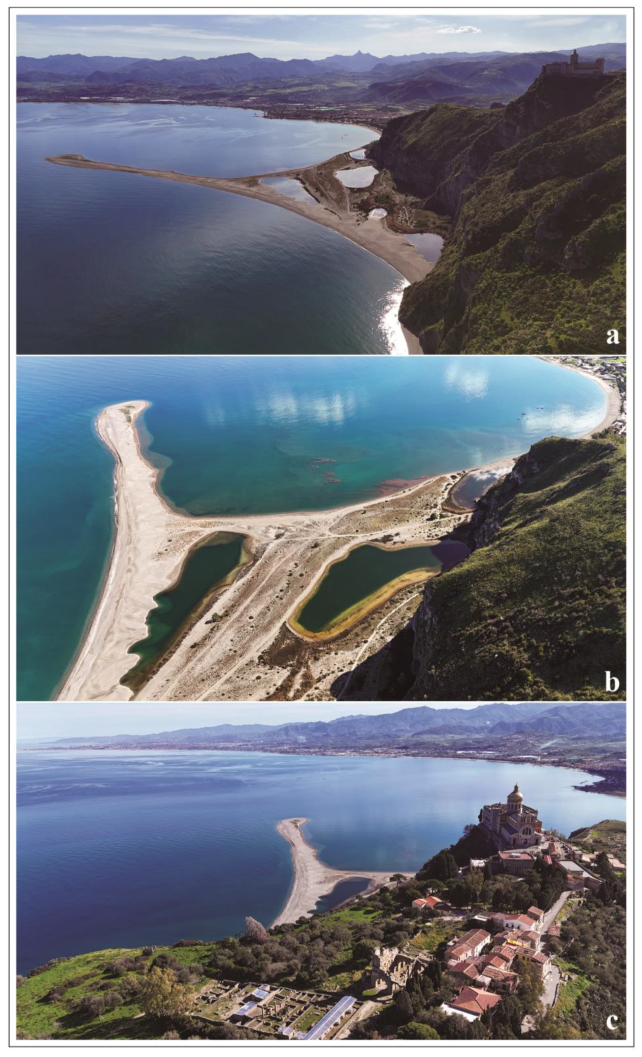
3.1.1. Origin and Evolution of the Oliveri–Tindari Lagoon and Spit
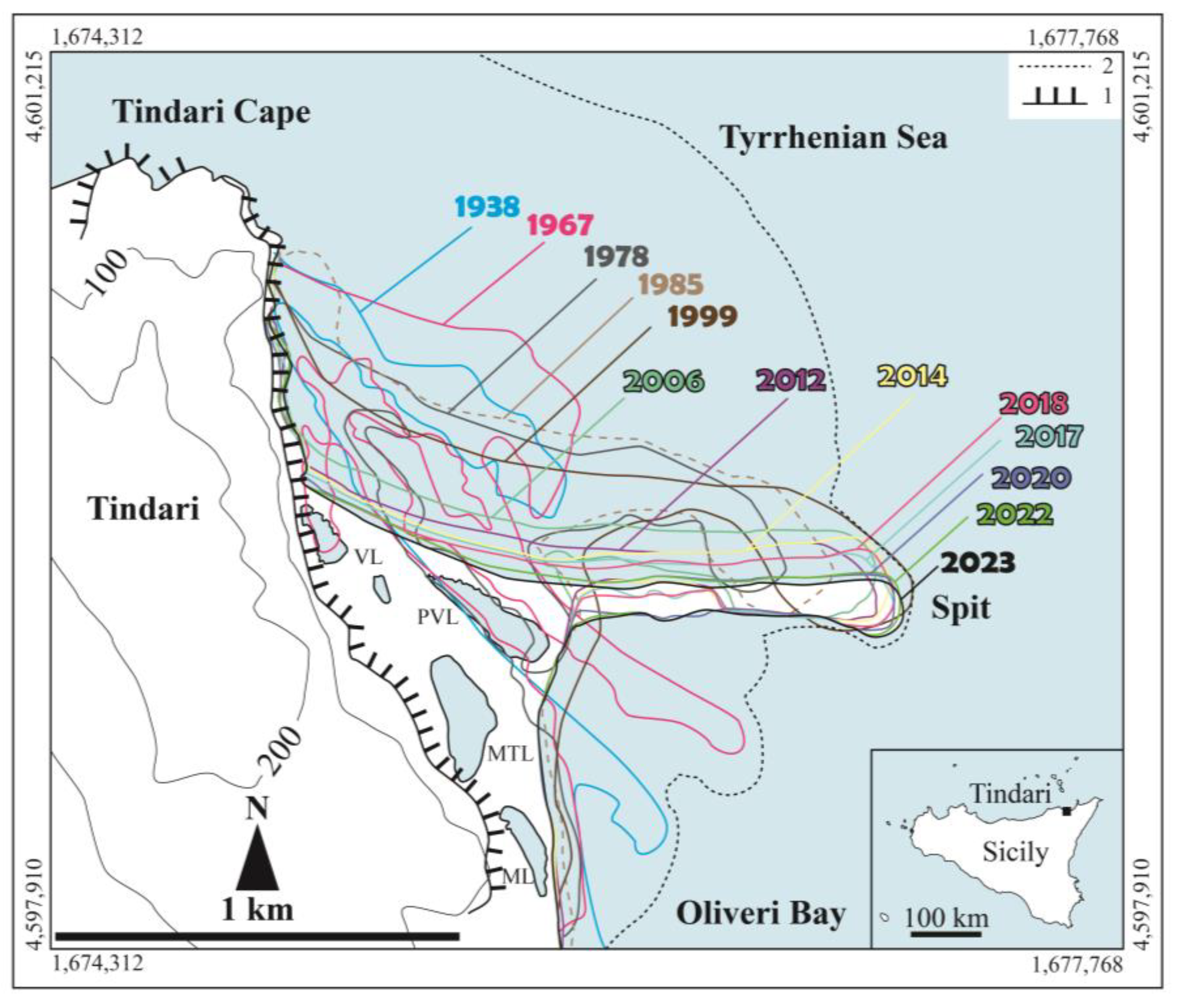
3.1.2. Spatiotemporal Evolution of the Oliveri–Tindari Shoreline
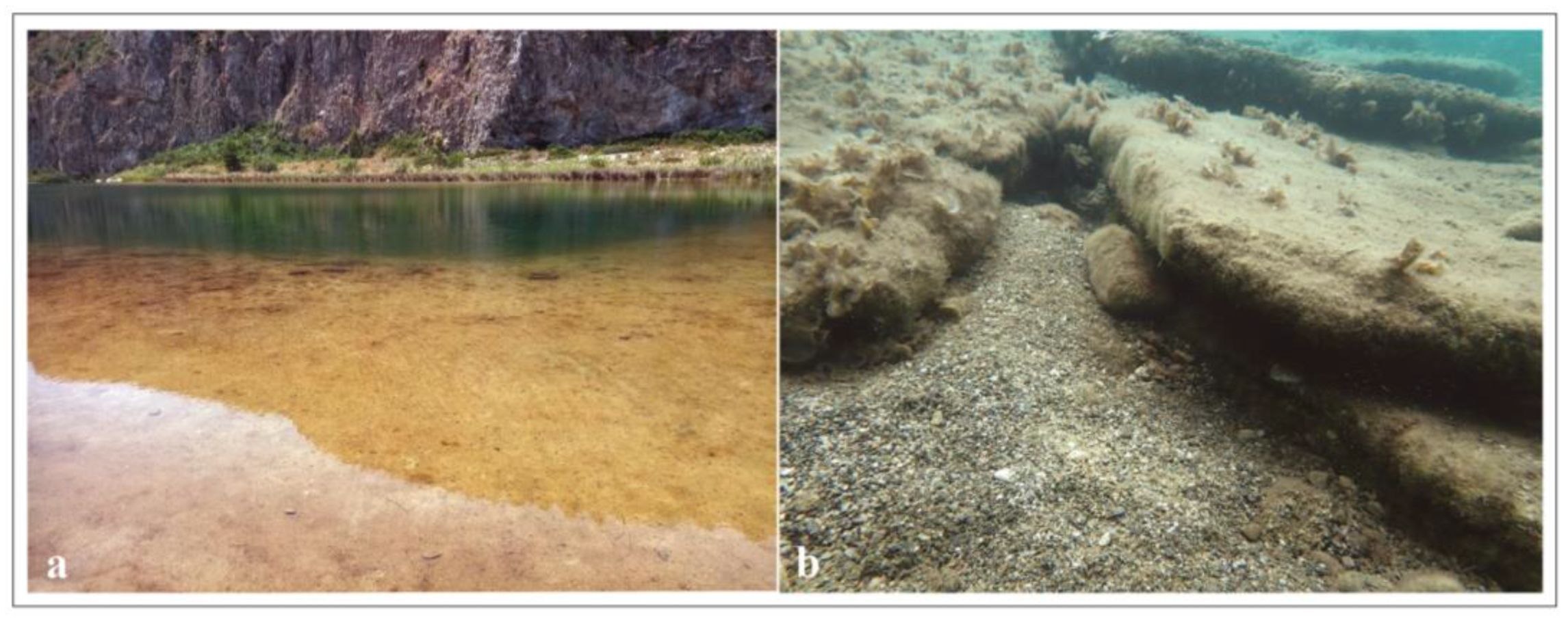
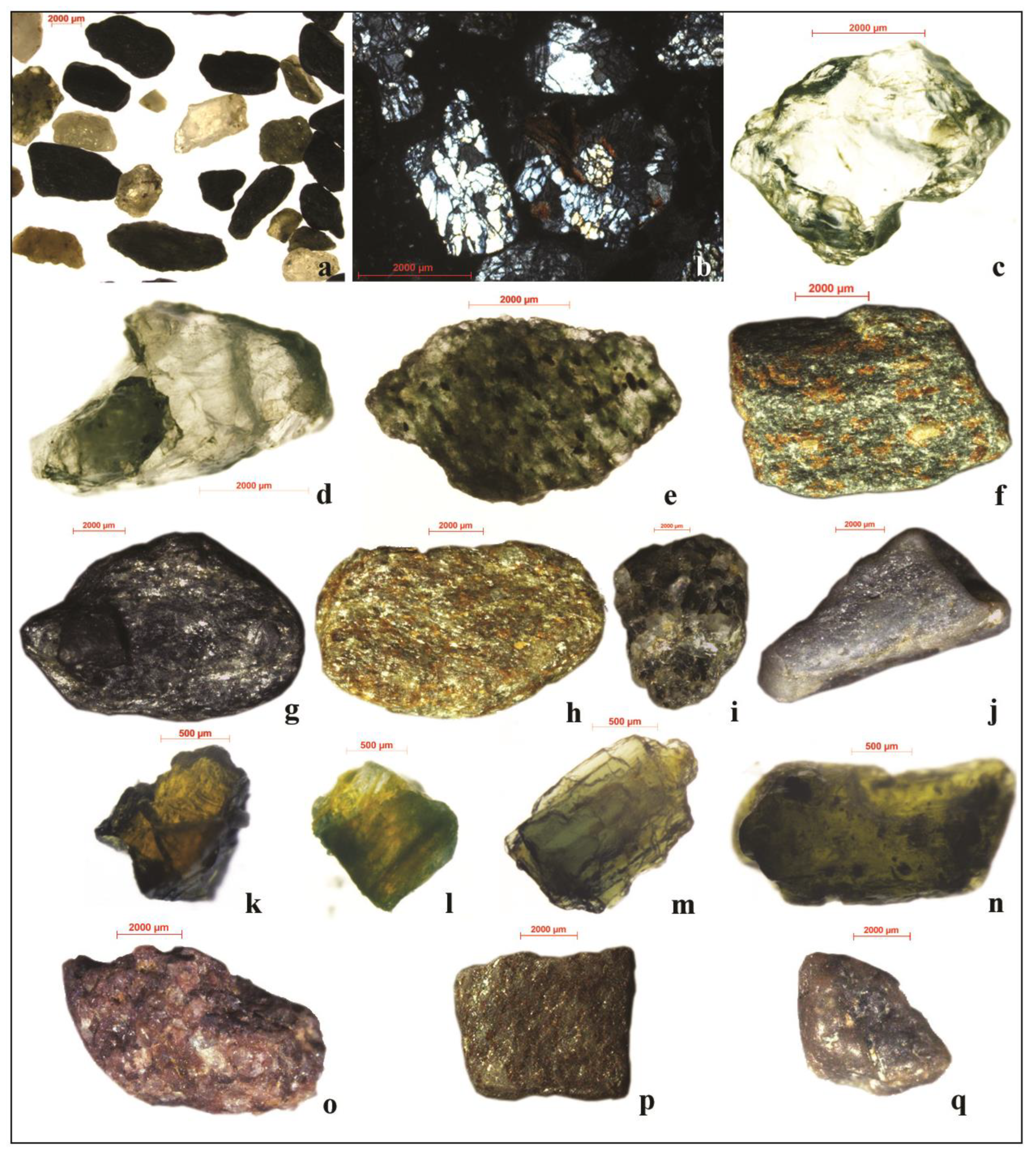
3.1.3. Textural and Mineralogical Observations
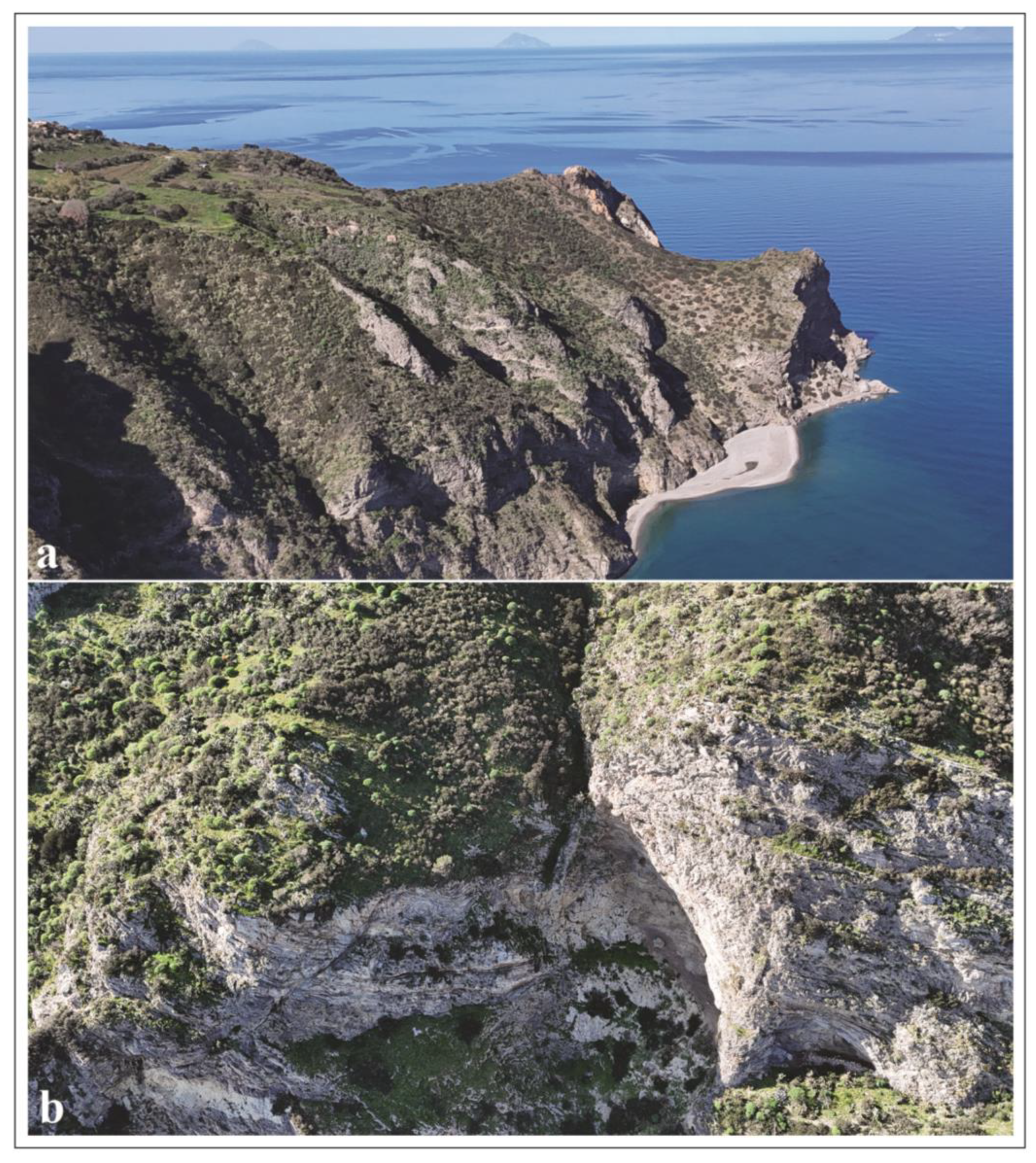
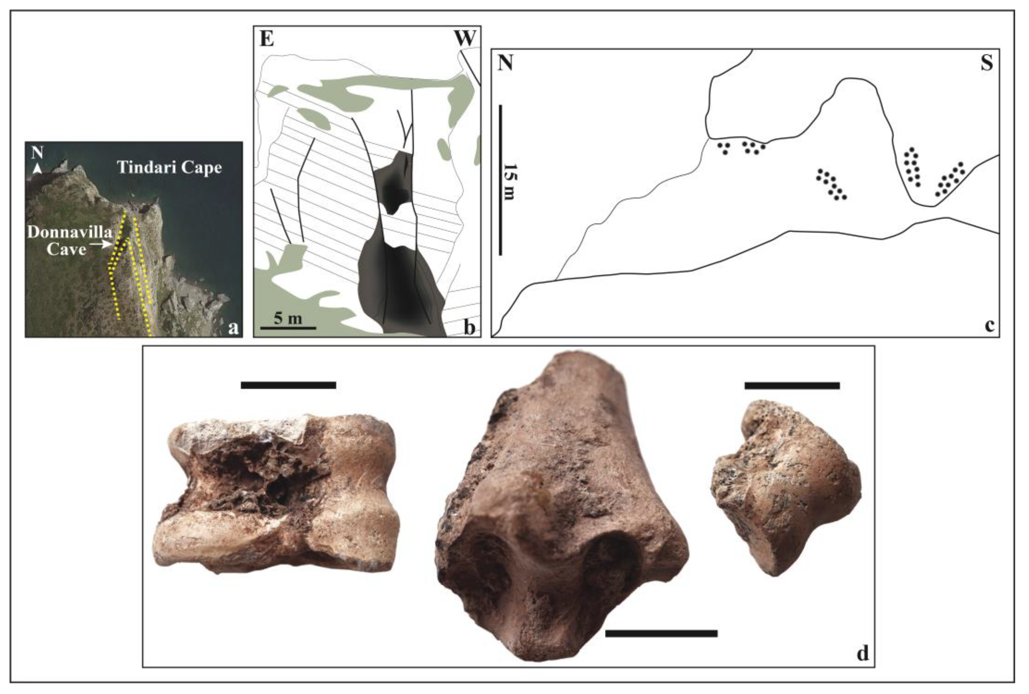
3.2. The Geoheritage of the Tindari Cape Promontory
3.3. Quantitative Assessment of Geodiversity
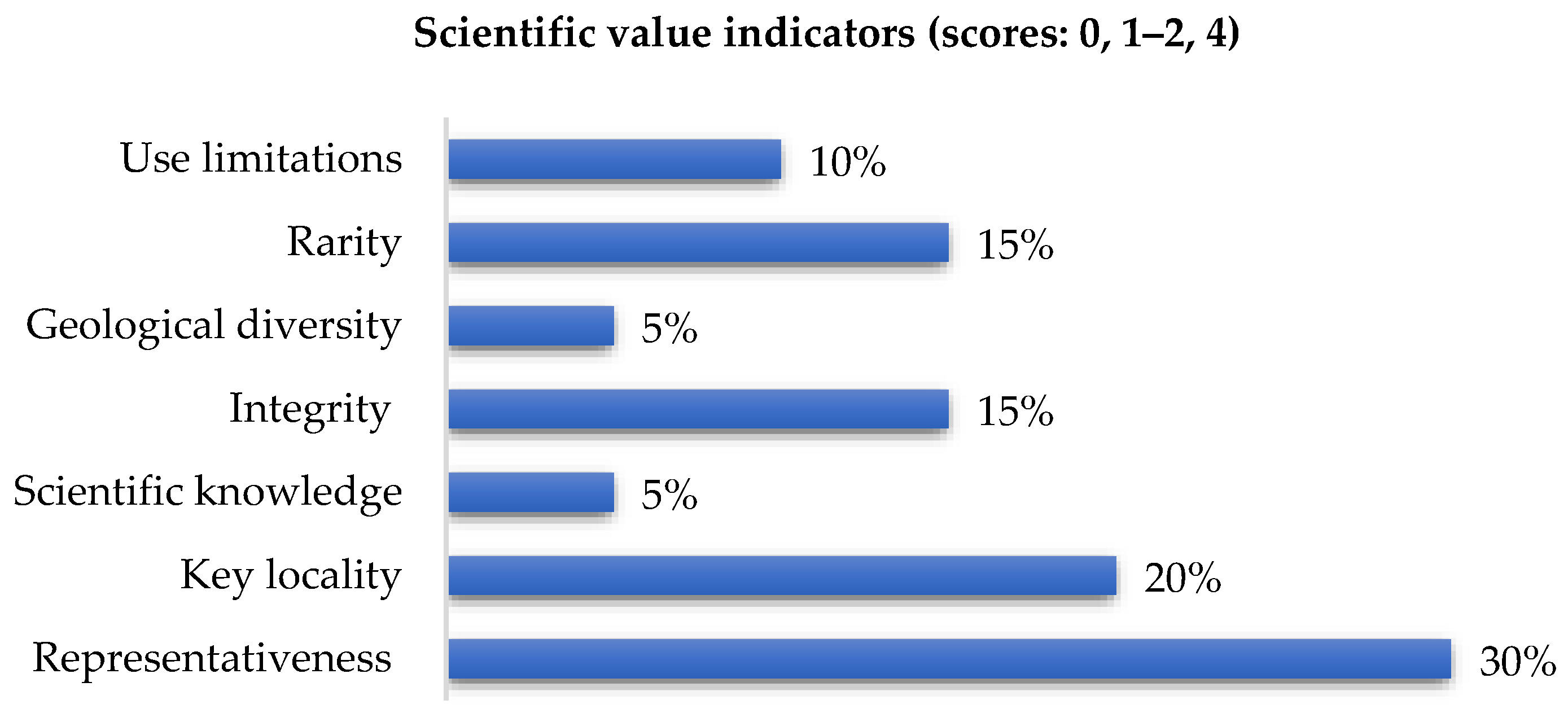
3.3.1. Scientific Value
3.3.2. Potential Educational Use
3.3.3. Potential Touristic Use
3.3.4. Degradation Risk
4. Discussion
4.1. Inventory of the Tindari Cape and Marinello Lakes Interim Geosite (Higher Institute for Environmental Protection and Research Procedure)
4.2. Quantitative Assessment of the Tindari Cape and Marinello Lakes Interim Geosite (Brilha Method)
4.3. Factors Regarding the Risk of Degradation in the Tindari Cape and Marinello Lakes Interim Geosite
5. Concluding Remarks
Author Contributions
Funding
Data Availability Statement
Acknowledgments
Conflicts of Interest
References
- Herrera-Franco, G.; Mata-Perelló, J.; Caicedo-Potosí, J.; Carrión-Mero, P. Vulnerability in geosites: A systematic literature review. In Sustainability in Practice. World Sustainability Series; Leal Filho, W., Frankenberger, F., Tortato, U., Eds.; Springer: Cham, Switzerland, 2023; pp. 395–407. [Google Scholar] [CrossRef]
- Wimbledon, W.A.P. GEOSITES—An International Union of Geological Sciences initiative to conserve our geological heritage. Pol. Geol. Inst. Spec. Pap. 1999, 2, 5–8. [Google Scholar]
- Wimbledon, W.A.P.; Smith-Meyer, S. Geoheritage in Europe and its conservation. Episodes 2013, 36, 68. [Google Scholar]
- Migoń, P. Geosites and Climate Change—A Review and Conceptual Framework. Geosciences 2024, 14, 153. [Google Scholar] [CrossRef]
- Brilha, J.B. Inventory and Quantitative Assessment of Geosites and Geodiversity Sites: A Review. Geoheritage 2016, 8, 119–134. [Google Scholar] [CrossRef]
- Zafeiropoulos, G.; Drinia, H. Comparative Analysis of Two Assessment Methods for the Geoeducational Values of Geosites: A Case Study from the Volcanic Island of Nisyros, SE Aegean Sea, Greece. Geosciences 2022, 12, 82. [Google Scholar] [CrossRef]
- Herrera-Franco, G.A.; Carrión-Mero, P.C.; Mora-Frank, C.V.; Caicedo-Potosí, J.K. Comparative analysis of methodologies for the evaluation of geosites in the context of the Santa Elena-Ancón geopark project. Int. J. Des. Nat. Ecodynamics 2020, 15, 183–188. [Google Scholar] [CrossRef]
- Zorlu, K.; Polat, S.; Yılmaz, A.; Dede, V. An integrated fuzzy-rough multi-criteria group decision-making model for quantitative assessment of geoheritage resources. Resour. Policy 2024, 90, 104773. [Google Scholar] [CrossRef]
- Zakharovskyi, V.; Németh, K.; Gravis, I.; Twemlow, C. Geosite Recognition Based on Qualitative-Quantitative Assessment in the Light of Core Geological Features of a Mio-Pliocene Volcanic Arc Setting of the Coromandel Peninsula, New Zealand. Geoheritage 2024, 16, 19. [Google Scholar] [CrossRef]
- National Inventory of Geosites (ISPRA). Available online: https://www.isprambiente.gov.it/it/progetti/cartella-progetti-in-corso/suolo-e-territorio-1/tutela-del-patrimonio-geologico-parchi-geominerari-geoparchi-e-geositi/il-censimento-nazionale-dei-geositi/inventario-nazionale-dei-geositi (accessed on 24 November 2024).
- Istituto Superiore per la Protezione E la Ricerca Ambientale (ISPRA). Available online: https://www.isprambiente.gov.it/it (accessed on 24 November 2024).
- Ministero Dell’Ambiente E Della Sicurezza Energetica (MASE). Available online: https://www.mase.gov.it/ (accessed on 26 February 2025).
- Regione Sicilia. Geositi Della Sicilia. Available online: https://www.regione.sicilia.it/istituzioni/regione/strutture-regionali/assessorato-territorio-ambiente/dipartimento-ambiente/geositi-sicilia (accessed on 24 November 2024).
- Bonardi, G.; Colonna, V.; Dietrich, D.; Giunta, G.; Liguori, V.; Lorenzoni, S.; Perrone, V.; Paglionico, A.; Piccarreta, G.; Russo, M.; et al. L’Arco Calabro-Peloritano Nell’Orogene Appenninico-Maghrebide; Guida all’escursione del 68° Congresso della S.G.I., Società Geologica Italiana, Tip.; Giannini: Napoli, Italy, 1976; pp. 1–36. [Google Scholar]
- Ghisetti, F. Evoluzione neotettonica dei principali sistemi di faglie della Calabria centrale. Boll. Soc. Geol. Ital. 1979, 98, 387–430. [Google Scholar]
- Lentini, F.; Carbone, S.; Grasso, M. Carta Geologica Della Provincia di Messina (Sicilia Nord-Orientale); Selca: Firenze, Italy, 2000. [Google Scholar]
- Messina, A.; Somma, R.; Macaione, E.; Carbone, G.; Careri, G. Peloritani continental crust composition (southern Italy): Geological and petrochemical evidence. Ital. J. Geosci. 2004, 123, 405–441. [Google Scholar]
- Cirrincione, R.; Pezzino, A. Caratteri strutturali dell’evento alpino nella serie mesozoica di Alì e nell’unità metamorfica di Mandanici (Peloritani orientali). Mem. Soc. Geol. Ital. 1991, 47, 263–272. [Google Scholar]
- Atzori, P.; Cirrincione, R.; Del Moro, A.; Pezzino, A. Structural, metamorphic and geochronologic features of the Alpine event in south-eastern sector of the Peloritani Mountains (Sicily). Period. Mineral. 1994, 63, 113–125. [Google Scholar]
- Bonardi, G.; Compagnoni, R.; Del Moro, A.; Macaione, E.; Messina, A.; Perrone, V. Rb-Sr age constraints on the Alpine metamorphic overprint in the Aspromonte nappe (Calabria-Peloritani composite terrane, southern Italy). Boll. Soc. Geol. Ital. 2008, 127, 173–190. [Google Scholar]
- Somma, R.; Martin Rojas, I.; Perrone, V. The stratigraphic record of the Alì-Montagnareale Unit (Peloritani Mountains, NE Sicily). Rend. Online Soc. Geol. Ital. 2013, 25, 106–115. [Google Scholar] [CrossRef]
- Manganaro, C. Relazione sul cosiddetto Porto del Tindaro, 1906. In Monografia Storica Dei Porti Dell’Antichità Nell’Italia Insulare; Officina poligrafica Italiana: Roma, Italy, 1808; pp. 355–357. [Google Scholar]
- Abbruzzese, D.; Aricò, F. Osservazioni geomorfologiche e fisico-chimiche sui laghi di Oliveri-Tindari. Boll. Pesca Piscic. Idrobiol. 1955, 10, 1–23. [Google Scholar]
- Faranda, F.; Gangemi, G.; Guglielmo, L. Nuove condizioni dell’arenile di Oliveri e dei laghetti salmastri Mergolo della Tonnara e Verde (Prime osservazioni). Atti Soc. Peloritana 1975, 21, 15–31. [Google Scholar]
- Giacobbe, S.; Giordano, R. Prime osservazioni sugli insediamenti bentonici della zona lagunare di Oliveri-Tindari (Messina). Atti Soc. Peloritana 1975, 21, 169–182. [Google Scholar]
- Giacobbe, S.; Giordano, R. Considerazioni sul rinvenimento di specie di Mactridae nell’Area lagunare di Oliveri-Tindari (Messina). Atti Soc. Peloritana 1976, 22, 135–147. [Google Scholar]
- Crisafi, E.; Giacobbe, S.; Leonardi, M. Nuove ricerche idrobiologiche nell’area lagunare di Oliveri-Tindari (Messina). Morfologia dei bacini e caratteristiche fisico-chimiche delle acque e dei sedimenti. Mem. Biol. Mar. Oceanogr. 1981, 4, 139–186. [Google Scholar]
- Giacobbe, S.; Leonardi, M. L’area lagunare di Oliveri-Tindari: Sue variazioni morfologiche recenti ed evoluzioni dei popolamenti a molluschi. In Proceeding of the VII Congresso Associazione Italiana DI Oceanologia E Limnologia, Trieste, Italy, 11–14 June 1986. [Google Scholar]
- Amore, C.; Giuffrida, E.; Zanini, A. Evoluzione temporale e dinamica litorale dell’area lagunare di Oliveri-Tindari (Messina). Boll. Acc. Gioenia Sc. Nat. 1991, 24, 117–131. [Google Scholar]
- Di Natale, R.; La Loggia, G. Analisi dell’evoluzione della costa prospiciente Capo Tindari ai fini della conservazione dei laghetti di Marinello. In Proceedings of the Del Convegno Problemi Ambientali E Tecnologie Avanzate, Palermo, Italy, 21–23 February 1991. [Google Scholar]
- Giacobbe, M.G.; Maimone, G.; Azzaro, F. Distribuzione del fitoplancton in un’area salmastra della Sicilia nord-orientale. Plant Biosyst. 1992, 126, 531–547. [Google Scholar] [CrossRef]
- Leonardi, M.; Giacobbe, S. The Oliveri-Tindari lagoon (Messina, Italy): Evolution of the trophic-sedimentary environment and mollusc communities in the last twenty years. In Mediterranean Ecosystems; Faranda, F.M., Guglielmo, L., Spezie, G., Eds.; Springer: Milano, Italy, 2001; pp. 305–310. [Google Scholar] [CrossRef]
- Randazzo, G.; Geremia, F.; Lanza, S. Temporal evolution of Tindari headland spit and Marinello coastal wetland system (NE Sicily). In Proceedings of the Del Convegno Lagoons and Coastal Wetlands in the Global Change Context: Impacts and Management Issues, Venezia, Italy, 26–28 April 2004. [Google Scholar]
- Spigo, U. Tindari. L’Area Archeologica E L’Antiquarium; Rebus Edizioni: Milazzo, Italy, 2005; pp. 1–54. [Google Scholar]
- Billi, A.; Barberi, G.; Faccenna, C.; Neri, G.; Pepe, F.; Sulli, A. Tectonics and seismicity of the Tindari Fault System, southern Italy: Crustal deformations at the transition between ongoing contractional and extensional domains located above the edge of a subducting slab. Tectonics 2006, 25, 1–20. [Google Scholar] [CrossRef]
- Privitera, S.; Torre, S. Le lagune di Oliveri-Tindari: Un caso di interazione tra azione antropica ed evoluzione ambientale. In Annali Della Facoltà DI Scienze Della Formazione; Università degli Studi di Catania: Catania, Italy, 2007; Volume 6, pp. 111–157. [Google Scholar]
- Leone, R.; Spigo, U. Tyndaris 1. Ricerche Nel Settore Occidentale: Campagne DI Scavo 1993–2004; Regione Siciliana: Palermo, Italy, 2008; pp. 1–345. ISBN 9788861640870. [Google Scholar]
- Bottari, C.; d’Amico, M.; Maugeri, M.; d’Addezio, G.; Urbini, S.; Marchetti, M.; Privitera, B. On the tracks of the ancient harbour of Tindari (NE Sicily). Méditerranée. Rev. Géographique Des Pays Méditerranéens/J. Mediterr. Geogr. 2009, 112, 69–74. [Google Scholar] [CrossRef]
- Bonfiglio, L.; Mangano, G.; Pino, P. The contribution of mammal-bearing deposits to timing Late Pleistocene tectonics of Cape Tindari (North Eastern Sicily). Riv. It. Pal. Strat. 2010, 116, 103–118. [Google Scholar] [CrossRef]
- Leonardi, M.; Azzaro, F.; Bergamasco, A.; Lanza, S. L’ecosistema litorale di Marinello (Messina): Dinamica geomorfologica e sedimentaria degli ultimi cinquant’anni. In Proceedings of the Del Quarto Simposio Internazionale—IL Monitoraggio Costiero Mediterraneo: Problematiche E Tecniche DI Misura, Livorno, Italy, 12–14 June 2012. [Google Scholar]
- Fasolo, M. Tyndaris E IL Suo Territorio. Volume I: Introduzione Alla Carta Archeologica Del Territorio DI Tindari; MediaGeo: Ciampino, Italy, 2013; pp. 1–184. ISBN -13: 978-8890875519. [Google Scholar]
- Cooper, J.A.G.; Jackson, D.W.T.; Randazzo, G. Introduction at sand and Gravel spits. In Sand and Gravel Spits (Coastal Research Library); Randazzo, G., Jackson, D., Cooper, J., Eds.; Springer International Publishing: New York, NY, USA, 2015; Volume 12, pp. 1–2. [Google Scholar] [CrossRef]
- Crisà, A.; Lanza, S.; Radazzo, G. The Historical Evolution of the Tindari-Marinello Spit (Patti, Messina, Italy). In Sand and Gravel Spits (Coastal Research Library); Randazzo, G., Jackson, D., Cooper, J., Eds.; Springer International Publishing: New York, NY, USA, 2015; Volume 12, pp. 103–121. [Google Scholar] [CrossRef]
- Antonioli, F.; Anzidei, M.; Lo Presti, V.; Scicchitano, G.; Spampinato, C.R.; Trainito, E.; Furlani, S. Anomolous multi-origin marine notch sites: Three case studies in the central Mediterranean Sea. Quat. Int. 2017, 439 Pt A, 4–16. [Google Scholar] [CrossRef]
- Cultrera, F.; Barreca, G.; Ferranti, L.; Monaco, C.; Pepe, F.; Passaro, S.; Barberi, G.; Bruno, V.; Burrato, P.; Mattia, M.; et al. Structural architecture and active deformation pattern in the northern sector of the Aeolian-Tindari-Letojanni fault system (SE Tyrrhenian Sea-NE Sicily) from integrated analysis of field, marine geophysical, seismological and geodetic data. Ital. J. Geosci. 2017, 136, 399–417. [Google Scholar] [CrossRef]
- Fleres, A.; Ronci, M.; Vagge, I. La Riserva Naturale Orientata “Laghetti di Marinello”. Ri-Vista. Ric. Per La Progett. Del Paesaggio 2017, 2, 162–178. [Google Scholar]
- Pappalardo, G.; Mineo, S.; Calcaterra, D. Geomechanical analysis of unstable rock wedges by means of geostructural and infrared thermography surveys. Ital. J. Eng. Geol. Environ. 2017, 1, 93–101. [Google Scholar] [CrossRef]
- Leonardi, M.; Bergamasco, A.; Giacobbe, S.; Azzaro, F.; Cosentino, A.; Crupi, A.; Crisafi, E. A four decades multiparametric investigation in a Mediterranean dynamic ecosystem: Mollusc assemblages answer to the environmental changes. Estuar. Coast. Shelf Sci. 2020, 234, 106625. [Google Scholar] [CrossRef]
- Caliò, D.; Mineo, S.; Pappalardo, G. Aerial photogrammetry used as a quick procedure for rock mass stability analysis in a nature reserve. Ital. J. Eng. Geol. Environ. 2023, 11–20. [Google Scholar] [CrossRef]
- Wentworth, C.K. A scale of Grade and class terms for clastic sediments. J. Geol. 1922, 30, 377–392. [Google Scholar] [CrossRef]
- Folk, R.L.; Ward, W.C. Brazos River bar (Texas). A study in the significance of grain size parameters. J. Sediment. Res. 1957, 27, 3–26. [Google Scholar] [CrossRef]
- Black, G.P.; Gonggrijp, G.P. Fundamental thoughts on Earth–science conservation. Jb. Geol. B-A 1990, 133, 655–657. [Google Scholar]
- ProGEO. A first attempt at a geosites framework for Europe—An IUGS initiative to support recognition of World heritage and European geodiversity. Geol. Balc. 1998, 28, 5–32. [Google Scholar]
- Brilha, J.B. Geoconservation and protected areas. Environ. Conserv. J. 2002, 29, 273–276. [Google Scholar] [CrossRef]
- Santangelo, N.; Santo, A.; Guida, D.; Lanzara, R.; Siervo, V. The geosites of the Cilento–Vallo di Diano national park (Campania region, southern Italy). Il Quat. 2005, 18, 103–114. [Google Scholar]
- Erikstad, L. History of geoconservation in Europe. In The History of Geoconservation; Burek, C.V., Prosser, C.D., Eds.; Geological Society Special Publication: London, UK, 2008; pp. 249–256. [Google Scholar] [CrossRef]
- Gray, J.M. Geodiversity: Developing the paradigma. Proc. Geol. Assoc. 2008, 119, 287–298. [Google Scholar] [CrossRef]
- Joyce, E.B. Australia’s Geoheritage: History of Study, A New Inventory of Geosites and Applications to Geotourism and Geoparks. Geoheritage 2010, 2, 39–56. [Google Scholar] [CrossRef]
- Lima, F.F.; Brilha, J.B.; Salamuni, E. Inventorying geological heritage in large territories: A methodological proposal applied to Brazil. Geoheritage 2010, 2, 91–99. [Google Scholar] [CrossRef]
- Prosser, C.D.; Burek, C.V.; Evans, D.H.; Gordon, J.E.; Kirkbride, V.B.; Rennie, A.F.; Walmsley, C.A. Conserving geodiversity sites in a changing climate: Management challenges and responses. Geoheritage 2010, 2, 123–136. [Google Scholar] [CrossRef]
- Ruban, D.A. Quantification of geodiversity and its loss. Proc. Geol. Assoc. 2010, 121, 326–333. [Google Scholar] [CrossRef]
- Henriques, M.H.; Pena dos Reis, R.; Brilha, J.; Mota, T.S. Geoconservation as an emerging geoscience. Geoheritage 2011, 3, 117–128. [Google Scholar] [CrossRef]
- Fassoulas, C.; Mouriki, D.; Dimitriou-Nikolakis, P.; Iliopoulos, G. Quantitative assessment of geotopes as an effective tool for geoheritage management. Geoheritage 2012, 4, 177–193. [Google Scholar] [CrossRef]
- Browne, M.A.E. Geodiversity and the role of the planning system in Scotland. Scott. Geogr. J. 2012, 128, 266–277. [Google Scholar] [CrossRef]
- Bollati, I.; Smiraglia, C.; Pelfini, M. Assessment and selection of geomorphosites and trails in the Miage Glacier Area (Western Italian Alps). Environ. Manag. 2013, 51, 951–967. [Google Scholar] [CrossRef]
- Gray, J.M. Geodiversity: Valuing and Conserving Abiotic Nature, 2nd ed.; Wiley-Blackwell: Chichester, UK, 2013; pp. 1–512. ISBN 978-0-470-74215-0. [Google Scholar]
- Pereira, D.I.; Pereira, P.; Brilha, J.; Santos, L. Geodiversity assessment of Paraná State (Brazil): An innovative approach. Environ. Manag. 2013, 52, 541–552. [Google Scholar] [CrossRef]
- Prosser, C.D. Our rich and varied geoconservation portfolio: The foundation for the future. Proc. Geol. Assoc. 2013, 124, 568–580. [Google Scholar]
- Tomić, N.; Božić, S. A modified geosite assessment model (M-GAM) and its application on the Lazar Canyon area (Serbia). Int. J. Environ. Res. 2014, 8, 1041–1052. [Google Scholar]
- Lagally, U.; Loth, R.; Schindelmann, C. The “day of Geosites” in Germany—A successful promotion tool for earth sciences. Geoheritage 2015, 7, 195–204. [Google Scholar] [CrossRef]
- Wang, L.; Tian, M.; Wang, L. Geodiversity, geoconservation and geotourism in Hong Kong Global Geopark of China. Proc. Geol. Assoc. 2015, 126, 426–437. [Google Scholar] [CrossRef]
- Bollati, I.; Reynard, E.; Palmieri, E.L.; Pelfini, M. Runoff impact on active geomorphosites in unconsolidated substrate. A comparison between landforms in glacial and marine clay sediments: Two case studies from the Swiss Alps and the Italian Apennines. Geoheritage 2016, 8, 61–75. [Google Scholar]
- Kelley, D.; Salazar, R. Geosites in the Galápagos Islands used for geology education programs. Geoheritage 2017, 9, 351–358. [Google Scholar] [CrossRef]
- Barasoain, D.; Azanza, B. Geoheritage and education: A practical example from the Rhinoceros of Toril 3 (Calatayud–Daroca Basin, Spain). Geoheritage 2018, 10, 363–374. [Google Scholar] [CrossRef]
- Brilha, J. Chapter 4—Geoheritage: Inventories and evaluation. In Geoheritage, Assessment, Protection, and Management; Elsevier Inc.: Maryland Heights, MO, USA, 2018; pp. 69–85. [Google Scholar] [CrossRef]
- Brilha, J. Chapter 18—Geoheritage and Geoparks. In Geoheritage, Assessment, Protection, and Management; Elsevier Inc.: Maryland Heights, MO, USA, 2018; pp. 323–335. [Google Scholar] [CrossRef]
- Gordon, J.E. Geoconservation principles and protected area management. Int. J. Geoherit. Parks 2019, 7, 199–210. [Google Scholar] [CrossRef]
- Albani, R.A.; Mansur, K.L.; Carvalho, I.S.; Santos, W.F.S. Quantitative evaluation of the geosites and geodiversity sites of João Dourado municipality (Bahia—Brazil). Geoheritage 2020, 12, 63–74. [Google Scholar] [CrossRef]
- Bollati, I.M.; Crosa Lenz, B.; Caironi, V. A multidisciplinary approach for physical landscape analysis: Scientific value and risk of degradation of outstanding landforms in the glacial plateau of the Loana Valley (Central-Western Italian Alps). Ital. J. Geosci. 2020, 139, 233–251. [Google Scholar] [CrossRef]
- Bollati, I.M.; Viani, C.; Masseroli, A.; Mortara, G.; Testa, B.; Tronti, G.; Pelfini, M. Emmanuel Reynard, Geodiversity of proglacial areas and implications for geosystem services: A review. Geomorphology 2023, 421, 108517. [Google Scholar] [CrossRef]
- Ansori, C.; Setiawan, N.I.; Warmada, I.W.; Yogaswara, H. Identification of geodiversity and evaluation of geosites to determine geopark themes of the Karangsambung-Karangbolong National Geopark, Kebumen, Indonesia. Int. J. Geoherit. Parks 2022, 10, 1–15. [Google Scholar] [CrossRef]
- Da Glória Garcia, M.; Queiroz, D.S.; Mucivuna, V.C. Geological diversity fostering actions in geoconservation: An overview of Brazil. Int. J. Geoherit. Parks 2022, 10, 507–522. [Google Scholar] [CrossRef]
- Najwer, A.; Jankowski, P.; Niesterowicz, J.; Zwoliński, Z. Geodiversity assessment with global and local spatial multicriteria analysis. Int. J. Appl. Earth Obs. Geoinf. 2022, 107, 102665. [Google Scholar] [CrossRef]
- Pardo-Igúzquiza, E.J.; Durán-Valsero, J.A.; Dowd, P.; Luque-Espinar, J.A.; Heredia, J.; Robledo-Ardila, P.A. Geodiversity of closed depressions in a high relief karst: Geoeducation asset and geotourism resource in the “Sierra de las Nieves” National Park (Málaga Province, Southern Spain). Int. J. Geoherit. Parks 2022, 10, 196–217. [Google Scholar] [CrossRef]
- Somma, R. The Inventory and Quantitative Assessment of Geodiversity as Strategic Tools for Promoting Sustainable Geoconservation and Geo-Education in the Peloritani Mountains (Italy). Educ. Sci. 2022, 12, 580. [Google Scholar] [CrossRef]
- Samodra, H.; Permanadewi, S.; Irzon, R.; Yunianto, B.; Ansori, C.; Junursyah, G.M.L.P.; Patriani, E.Y.; Maryanto, S. The geodiversity site of Sentono Gentong in Pacitan, Indonesia: Geological characteristics and quantitative assessment. Int. J. Geoherit. Parks 2024, 12, 196–208. [Google Scholar] [CrossRef]
- Somma, R.; Spoto, S.E.; Giacobbe, S. Geological and Structural Framework, Inventory, and Quantitative Assessment of Geodiversity: The Case Study of the Lake Faro and Lake Ganzirri Global Geosites (Italy). Geosciences 2024, 14, 236. [Google Scholar] [CrossRef]
- Somma, R.; Giuffrè, E.; Amonullozoda, S.; Spoto, S.E.; Giacobbe, A.; Giacobbe, S. Geological and Ecological Insights on the Lake Faro Global Geosite Within the Messina Strait Framework (Italy). Geosciences 2024, 14, 319. [Google Scholar] [CrossRef]
- Barnes, R.S.K. Coastal Lagoons; Cambridge University Press: New York, NY, USA, 1980; pp. 1–120. [Google Scholar]
- Badcock, R.M.; Barnes, R.S.K. Coastal lagoons. The natural history of a neglected habitat. J. Ecol. 1981, 69, 1061. [Google Scholar] [CrossRef]
- Istituto Superiore per la Protezione e la Ricerca Ambientale (ISPRA). ITaly HAzards from CApable Faulting. Available online: https://www.isprambiente.gov.it/en/projects/soil-and-territory/italy-hazards-from-capable-faulting (accessed on 8 February 2025).


| Scientific Value Total Weighted Score Interval | Category |
|---|---|
| 0–200 (Low) | Geodiversity site |
| 201–300 (Moderate) | Geodiversity site |
| 301–400 (High) | Geosite |
| Scientific Value (4–2–1) | Weight (%) | Score | Weighted Score |
|---|---|---|---|
| A. Representativeness | 30 | 4 | 1.2 |
| B. Key locality | 20 | 1 | 0.2 |
| C. Scientific knowledge | 5 | 4 | 0.2 |
| D. Integrity | 15 | 4 | 0.6 |
| E. Geological diversity | 5 | 4 | 0.2 |
| F. Rarity | 15 | 4 | 0.6 |
| G. Use limitations | 10 | 2 | 0.2 |
| Potential Educational Use (4–3–2–1) | Weight | Score | Weighted Score |
|---|---|---|---|
| A. Vulnerability | 10 | 4 | 0.4 |
| B. Accessibility | 10 | 1 | 0.1 |
| C. Use limitations | 5 | 2 | 0.1 |
| D. Safety | 10 | 2 | 0.2 |
| E. Logistics | 5 | 4 | 0.2 |
| F. Density population | 5 | 3 | 0.15 |
| G. Association with other values | 5 | 4 | 0.2 |
| H. Scenery | 5 | 3 | 0.15 |
| I. Uniqueness | 5 | 4 | 0.2 |
| J. Observation conditions | 10 | 2 | 0.2 |
| K. Didactic potential | 20 | 1 | 0.2 |
| L. Geological diversity | 10 | 4 | 0.4 |
| Potential Touristic Use (4–3–2–1) | Weight | Score | Weighted Score |
|---|---|---|---|
| A. Vulnerability | 10 | 4 | 0.4 |
| B. Accessibility | 10 | 1 | 0.1 |
| C. Use limitations | 5 | 2 | 0.1 |
| D. Safety | 10 | 2 | 0.2 |
| E. Logistics | 5 | 4 | 0.2 |
| F. Density population | 5 | 3 | 0.15 |
| G. Association with other values | 5 | 4 | 0.2 |
| H. Scenery | 15 | 3 | 0.45 |
| I. Uniqueness | 10 | 4 | 0.4 |
| J. Observation conditions | 5 | 2 | 0.1 |
| K. Interpretative potential | 10 | 3 | 0.3 |
| L. Economic level | 5 | 2 | 0.1 |
| M. Proximity of recreational areas | 5 | 4 | 0.2 |
| Degradation Risk (4–3–2–1) | Weight | Score | Weighted Score |
|---|---|---|---|
| A. Deterioration of geological elements | 35 | 4 | 1.4 |
| B. Proximity to areas/activities with potential to cause degradation | 20 | 4 | 0.8 |
| C. Legal protection | 20 | 1 | 0.2 |
| D. Accessibility | 15 | 1 | 0.15 |
| E. Density of population | 10 | 3 | 0.3 |
| Information | Description |
|---|---|
| Tindari Cape and Marinello Lakes |
| Yes |
| University of Messina. Email address: rsomma@unime.it |
| Field survey and literature review |
| 30 September 2024 |
| Tindari Cape (Tindari) and Oliveri (Marinello) (Messina, Italy) Geographic coordinates: 1675650, 4599375 (WGS 84/Pseudo Mercator) |
| Lagoon: Primary and preeminent geomorphological scientific interest related to active geomorphosites (with secondary geological/sedimentological value). Lagoonal system with elements of rarity (at regional, national, and international scale), representativeness (the “best” examples of an active geomorphosite at a regional, national, and international scale), and exemplarity (active geomorphosite that can be used to describe its evolution and genetic process). Contextual interest, characterized by secondary-type naturalistic interest, due to significative fauna and vegetation. Tindari Cape: Secondary geomorphological, structural, and palaeontological interest. |
| Global |
| Lagoon: Coastal transitional system with five small-sized brackish ponds and a spit. Tindari Cape: Marble cliffs with a cave (Donnavilla Cave with Quaternary mammal bone continental deposits) and emerged notches and Lithophaga lithophaga holes that underwent uplift. |
| Figure 1, Figure 2, Figure 3, Figure 4, Figure 5, Figure 6, Figure 7, Figure 8, Figure 9, Figure 10, Figure 11, Figure 12, Figure 13, Figure 14 and Figure 15, Table 2, Table 3, Table 4, Table 5 and Table 6 in present research |
| Lagoon: Sandy, very fine gravels, moderately sorted and with mesokurtic and symmetrical grain size distributions, composed of metamorphic origin lithoclasts (prevailing sericite-bearing phyllites, quartz, feldspars, minor graphite-bearing phyllites, gneiss, marbles, traces of garnet, staurolite, pyroxene; see Figure 12a,n), with a minor contribution of sedimentary origin grains (chert and Verrucano-type metasandstones and metapelite; see Figure 12o,p). Tindari Cape: Two mica marbles (Figure 14) with intercalation of layers of gneiss and micaschist, intruded by aplo-pegmatitic rocks, affected by Variscan metamorphism. |
| Lagoon: Holocene EpochTindari Cape: Paleozoic Era |
| Lagoon: 1880 (or since 1805 according to oral witnesses) Tindari Cape: Mammal vertebrate deposit (Upper Pleistocene), uplift (6.5 and 5 ka cal BP) |
| Global |
| It is due to natural factors (coastal dynamics). |
| Lagoon: It is located on a low-relief coastal plain. Tindari Cape: It is located on a promontory with steep cliffs facing the sea. |
| Lagoon: Access is possible along several dirt paths (no direct access by paved road). Access is interdicted under steep cliffs due to block collapse. Tindari Cape: Access to reach the additional geological elements (cave) is very difficult on foot, lacking any safety measures along the very narrow dirt paths. Direct access to the submerged notch is achieved by swimming, whereas the uplifted notches may be observed by boat. |
| Protected area (ONR Oliveri–Tindari Lakes) |
| Yes (managing body and public owner: Metropolitan City of Messina) |
| Site with fragility and vulnerability. Risk of degradation due to natural climate and anthropogenic factors. |
| Unnecessary (being ONR) |
| Criterion | Total Weighted Score |
|---|---|
| Scientific Value | 320 |
| Potential Education Use | 250 |
| Potential Touristic Use | 290 |
| Degradation Risk | 285 |
Disclaimer/Publisher’s Note: The statements, opinions and data contained in all publications are solely those of the individual author(s) and contributor(s) and not of MDPI and/or the editor(s). MDPI and/or the editor(s) disclaim responsibility for any injury to people or property resulting from any ideas, methods, instructions or products referred to in the content. |
© 2025 by the authors. Licensee MDPI, Basel, Switzerland. This article is an open access article distributed under the terms and conditions of the Creative Commons Attribution (CC BY) license (https://creativecommons.org/licenses/by/4.0/).
Share and Cite
Somma, R.; Gatì, I.A.; Giacobbe, S. Inventory and Quantitative Assessment of Coastal Geoheritage: Contribution to the Proposal of an Active Geomorphosite. Geosciences 2025, 15, 125. https://doi.org/10.3390/geosciences15040125
Somma R, Gatì IA, Giacobbe S. Inventory and Quantitative Assessment of Coastal Geoheritage: Contribution to the Proposal of an Active Geomorphosite. Geosciences. 2025; 15(4):125. https://doi.org/10.3390/geosciences15040125
Chicago/Turabian StyleSomma, Roberta, Ivan Angelo Gatì, and Salvatore Giacobbe. 2025. "Inventory and Quantitative Assessment of Coastal Geoheritage: Contribution to the Proposal of an Active Geomorphosite" Geosciences 15, no. 4: 125. https://doi.org/10.3390/geosciences15040125
APA StyleSomma, R., Gatì, I. A., & Giacobbe, S. (2025). Inventory and Quantitative Assessment of Coastal Geoheritage: Contribution to the Proposal of an Active Geomorphosite. Geosciences, 15(4), 125. https://doi.org/10.3390/geosciences15040125