Article

Medieval Overexploitation of Peat Triggered Large-Scale Drowning and Permanent Land Loss in Coastal North Frisia (Wadden Sea Region, Germany)

1
Institute of Geography, Johannes Gutenberg University Mainz, 55099 Mainz, Germany
2
Institute of Geosciences, Kiel University, 24118 Kiel, Germany
3
Leibniz-Zentrum für Archäologie (LEIZA) Mainz, Centre for Baltic and Scandinavian Archaeology (ZBSA), 24837 Schleswig, Germany
4
State Archaeology Department Schleswig-Holstein, 24837 Schleswig, Germany
*
Author to whom correspondence should be addressed.
Geosciences 2025, 15(1), 1; https://doi.org/10.3390/geosciences15010001
Submission received: 13 November 2024 / Revised: 15 December 2024 / Accepted: 17 December 2024 / Published: 24 December 2024
(This article belongs to the Section Natural Hazards)

Abstract

:
Along the southern North Sea coast from the Netherlands to Denmark, human cultivation efforts have created a unique cultural landscape. Since the Middle Ages, these interactions between humans and natural forces have induced major coastal changes. In North Frisia (Germany), storm floods in 1362 AD and 1634 AD turned wide areas of embanked cultural land into tidal flats. Systematic geoarchaeological investigations between Nordstrand and Hallig Südfall comprise coring, trenching, sedimentary, geochemical and microfaunal palaeoenvironmental parameter analyses and radiocarbon dating. Together with geophysical prospection results and archaeological surveys, they give insights into the landscape’s development and causes for land losses. Results reveal that fens and bogs dominated from c. 800 BC to 1000 AD but are mostly missing in the stratigraphy. Instead, we found 12th to 14th cent. AD settlement remains directly on top of a pre-800 BC fossil marsh. This hiatus of c. 2000 years combined with local ‘Hufen’ settlements implies an extensive removal of peat during cultivation eventually resulting in the use of underlying marshland for agricultural purposes. Fifteenth cent. AD tidal flat deposits on top of the cultivated marsh prove that human impact lowered the ground surface below the mean high water of that time, clearly increasing the coastal vulnerability. We consider these intensive human–environment interactions as a decisive trigger for the massive loss of land and establishment of the tidal flats in North Frisia that are currently part of the UNESCO World Heritage “Wadden Sea”.

1. Introduction

Reaching from the Netherlands to Denmark, an extensive amphibious zone of tidal flats, salt marshes and fenlands developed along the southern North Sea coast during the Holocene sea-level rise [1]. In the Netherlands, major changes to the natural environment already followed human impact in the (pre-) Roman Iron Age [2,3]. But it is mostly since medieval times that the entire highly dynamic landscape experienced extensive major (geomorphological) transformations. Today’s Wadden Sea region—the tidal flat UNESCO World Heritage site of globally unique ecological value and adjacent coastal marsh areas [4]—is in fact the result of intensive interaction between humans and natural forces. It is as such considered a cultural landscape of exceptional historical value (e.g., [5,6]).
For more than 1500 years, humans inhabited the nearly unprotected salt marshes along the shores of the southern North Sea, successfully adapting to the regularly flooded (semi-)aquatic marine environment [7,8,9]. Large-scale land reclamation only started around the 11th cent. AD [10]. Dike construction, intensified drainage of marshland and peat extraction for melioration, fuel or salt production created a distinct cultural landscape pattern all across the Wadden Sea region [5,11,12].
Medieval dike construction drastically limited the salt marshes’ water storage capacities and reduced sediment supply along the Wadden Sea coast, thus marking a decisive turning point from living with to living against the sea [7,9]. This meant dealing with intensified extreme flood events.
Mostly caused by extratropical cyclones [13], but rarely also short-term weather anomalies (‘meteotsunamis’ [14,15]), the long history of flood events is well documented by both historical records (e.g., [16,17]) and geoscientific evidence (e.g., [18,19,20,21]).
Well-known historic events include, e.g., the St. Juliana’s flood in AD 1164, Lucia’s flood in AD 1287, the 2nd Marcellus’ flood in AD 1362 (the so-called 1st Grote Mandränke), Burchardi flood in AD 1634 (the so-called 2nd Grote Mandränke), Christmas flood in AD 1717 and February flood in AD 1825 [13,16,17,22,23,24]. Besides vast devastation and numerous casualties, some storm surges caused immense land loss and thus massive changes in the Wadden Sea region’s coastal morphology (e.g., Zuyderzee, NL [25]; Dollart and Jade Bay, D [17,26]; Skalligen peninsula, DK [18]). In some areas, drowned land could be regained, but in others, it was permanently lost [17,27].
Storm surge-related coastal destruction and changes culminated in high to late medieval and early modern times. Possible causes are as follows.
  • Storm frequency and intensity. Palaeoclimate reconstructions for NW Europe imply an increased storminess during the Medieval Warm Period/Medieval Climate Anomaly (MWP, beginning c. 950–1350 AD, e.g., [21,28,29,30,31,32]) and point to less frequent but more intense storms at the transition to and beginning of the Little Ice Age (LIA, c. 1400–1850 AD, e.g., [16,29,32]).
  • Geological setting. Natural processes like compaction in the Holocene sedimentary sequence and subsurface structures like Pleistocene valleys may increase a region’s vulnerability to flooding, as they cause local land subsidence and provide pathways for floods (e.g., [33,34,35]).
  • Sea-level evolution. Reconstructions of medieval sea level evolution in the Wadden Sea region remain vague (e.g., [36]), but archaeological evidence point to an at least locally increasing influence of the North Sea from c. 1100 AD onwards (e.g., [37]).
  • Coastal protection. The human-made reduction in flooding space caused by large-scale dike building significantly increased water levels during high tide and storm surges [8,11]. At the same time, early dikes were still low and their maintenance often insufficient due to socio-political conflicts or epidemics [38,39,40,41,42], all together considerably increasing the risk of dike breaches and catastrophic effects of storm surges.
  • Land reclamation. Draining of marsh- and fenlands initiated a self-enhancing downward spiral of sediment compaction and/or oxidation of peat, subsidence, and thus lowering of the already low-lying ground surface [8,9,41,43]. Large-scale peat extraction for melioration, heating and salt production further enhanced this process [44,45,46].
Both natural processes and medieval to early modern human–environment interactions created a cultural landscape highly vulnerable and extremely prone to flooding, making the dike an indispensable feature of the Wadden Sea region [5,7,8,9,11].
Along the German North Sea coast, greatest land loss is associated with the 1362 AD flood [47,48], which especially hit North Frisia (Figure 1A), where large-scale colonisation and systematic reclamation had only started around 1100 AD [49,50]. Here, amphibious conditions and extensive peat formation long prevented permanent human occupation [1,51]. Likely driven by the Danish Kingdom [52], recruited West Frisian settlers accomplished the transformation towards a cultural landscape within just two centuries [49,50,53]. In 1362 AD, though, these cultivated areas became permanently inundated in the order of hundreds of square kilometres and—unlike in other Wadden Sea areas—could not be reclaimed but irreversibly turned from fertile marshland to tidal flats [20].
As this major storm event caused a gap in both the stratigraphy and the historical records of North Frisia, the actual causes for the extensive and lasting loss of land are still a matter of debate. Reliable written sources are rare, and in modern social perception, it is mostly the historically grown myth about the destruction and drowning of the well-known medieval trading centre Rungholt (Hallig Südfall area, Figure 1B,C) by the 1362 AD event that stands out [54,55,56,57].
Figure 1. (A) The Wadden Sea of North Frisia extends from the Eiderstedt Peninsula to the island of Sylt. Major coastal changes occurred during the AD 1362 (coastline unknown) and AD 1634 (orange line) storm floods that led to the present-day shape of the coastline and tidal flats (modified after [27]). (B) Long known medieval cultural remains between the Nordstrand peninsula and Hallig Südfall (e.g., [58]) are now investigated along different transects (T1–3). Geophysical, geoarchaeological and archaeological methods [20,59] enable the localisation and extrapolation of settlement structures for a reconstruction of the drowned landscape. Medieval settlement patterns vary from (C) rows of terps with elongated parcels and dense network of drainage ditches (modified after [60]) to (D) single terps with irregular parcels and partly natural drainage (modified after [35]). On western Nordstrand, cultivated medieval marshland is still preserved in its original form.
Geosciences 15 00001 g001
Today, North Frisia stands as a symbol for the devastating effects of storm floods [61] and the Rungholt study area acts as a model region for the investigation and reconstruction of drowned medieval landscapes in the whole Wadden Sea region [60]. The tidal flats offer a unique conservation situation and represent a high-resolution archive for medieval human activities and changing environments. Sporadically exposed by wind and waves, medieval traces allow valuable insights into the rise and failure of this drowned cultural landscape [59,60,62,63].
Recent results point to a thriving society strongly involved in transregional maritime trade and able to establish major coastal infrastructure, but also imply intense exploitation of natural resources [20,46,60]. This study therefore seeks to do the following:
  • Reconstruct the coastal landscape development of North Frisia prior to land reclamation based on sedimentological and geomorphological data and identify natural conditions and resources met by medieval Frisian settlers;
  • Decipher medieval human impact in terms of cultivation measures and use of resources;
  • Evaluate the effects and consequences of medieval human–environment interactions with respect to coastal vulnerability and the major/drastic coastal changes induced by the 1362 AD storm event.

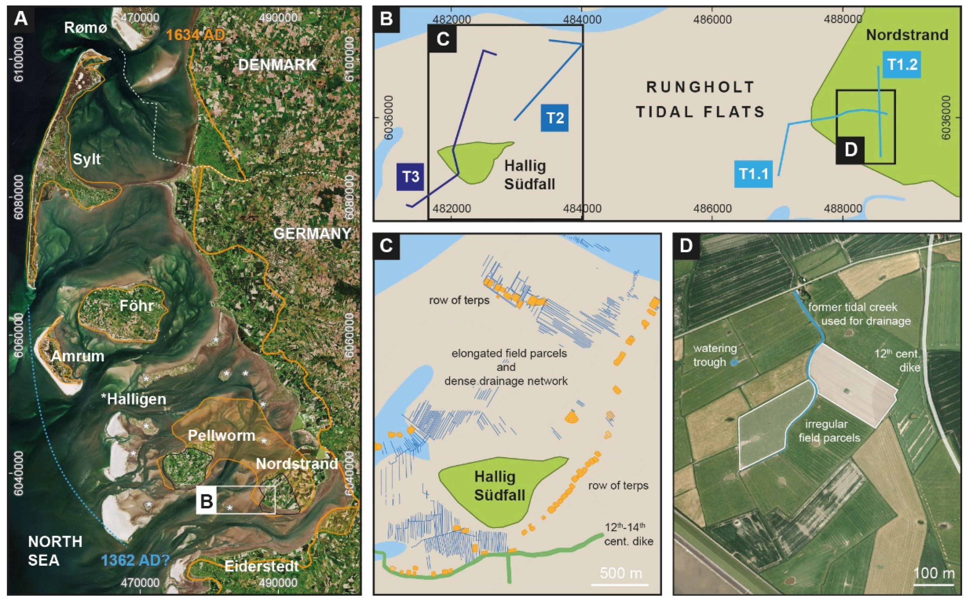
2. ‘Type Case’ Approach

Until recently, our understanding of the drowned cultural landscape preserved in North Frisia’s tidal flats was mostly based on regular (archaeological) surveys, a few previous research projects (e.g., [64]) and a long local tradition of citizen science (e.g., [58,65,66]). But the sheer size (>1500 km2), prevailing natural conditions (tides, weather and accessibility) and recent sediments covering most remains so far prevented a systematic prospection of the tidal flats, calling for a novel approach.
To overcome the challenges of tidal flat research, we established the interdisciplinary, so-called ‘type case’ approach, which combines state-of-the-art geophysical, geoarchaeological and archaeological methods (Figure 2 [20,35,59,60,67]). It particularly allows us to decipher the role of human impact and potential causes for the large-scale drowning and permanent loss of land in North Frisia. The latter is quite unique to the Wadden Sea region and still characterises the shape of the coast to this day. Independent of random finds and specifically adapted to the tidal flats and coastal marshlands, it gives a powerful tool that, for the first time, allows for a diachronic large-scale investigation and reconstruction of drowned (cultural) landscapes, including entire settlements.
This study focusses on the geoarchaeological dataset. Since 2016, we have recovered c. 150 sediment cores from the tidal flats and adjacent (salt) marshes of Hallig Südfall and the Nordstrand peninsula based on geophysical prospection results. Here, we present new stratigraphic data from 28 cores (Table S1) and also integrate previously published data [20,35,59,60,67,68] to create a comprehensive large-scale palaeogeographic reconstruction of the Rungholt study area (cf. Figure 1B).

3. Materials and Methods

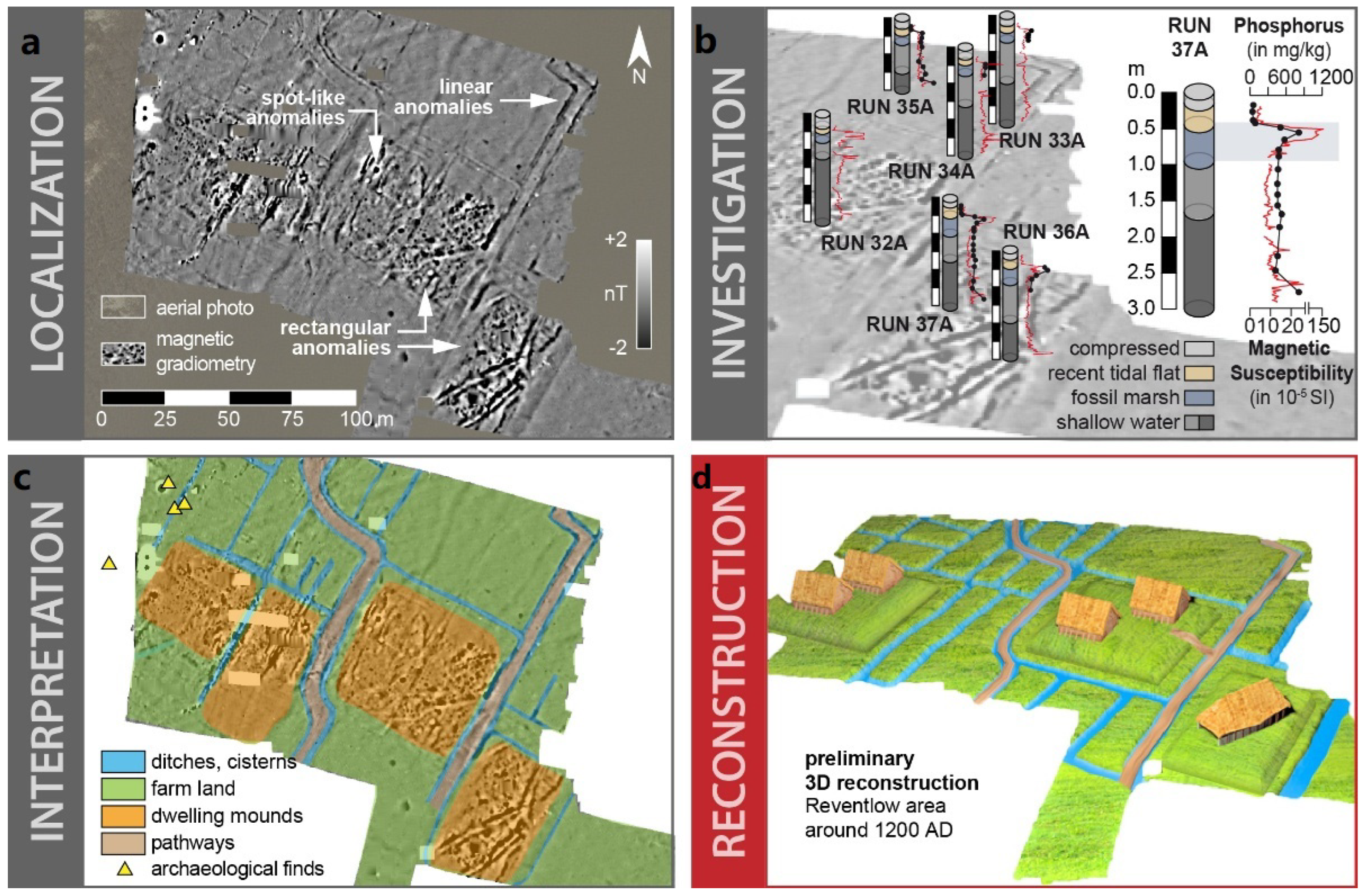
3.1. Geophysical and Archaeological Prospection

Magnetic gradiometry, seismics and electromagnetic induction see [59,60,67] for further details on the methodology and results combined with the evaluation of aerial image time series, archaeological survey and interpretation of prospection results provide maps of medieval settlement sites and the basis for the selection of coring sites.

3.2. Coring and Trenching

Coring, trenching and palaeoenvironmental parameter (PEP) analyses allow for a detailed reconstruction of the natural palaeolandscape development and identification of human impact. This study uses coring and trenching, palaeoenvironmental parameter (PEP) analyses of sediment samples and radiocarbon dating to decipher the local sedimentary record and reconstruct the natural coastal landscape development, human impact and effects of storm floods.
Cores were drilled with an engine-driven coring device (Atlas Copco Cobra PROi) using closed steel augers with plastic liners of 5 cm in diameter. Cores were opened, cleaned, photographed, described and sampled in the laboratory. Trenches were excavated using a 1 × 1 m2 metal frame, specially developed for and adapted to the requirements of tidal flat environments (Wilken & Hadler et al. 2024). Descriptions of stratigraphic units followed the standard procedure given by [69,70] and comprised criteria like grain-size, sediment colour, carbonate content, macrofossil content, archaeological artefacts, etc. Results are compared to previously published stratigraphic data [20,35,60,67,68,71] (Table S1).

3.3. Sedimentary, Geochemical and Microfaunal Palaeoenvironmental Parameter (PEP) Analyses

To characterise the palaeoenvironmental conditions of each stratigraphic unit and identify different sedimentary facies, sediment cores underwent a broad multi-proxy analysis [20,35,71].
Grain-size analyses were accomplished for bulk samples using the sieving and pipette method [72], including a pre-treatment with H2O2 and HCl to remove organic and carbonate components [73]. Further grain-size parameters were calculated with GRADISTAT [74].
To estimate organic matter, sediments were heated for 2.5 h at 550 °C for loss on ignition (LOI). Obtained LOI values were corrected for structural water loss by subtracting 0.1% of LOI per 1% of clay [73,75,76].
Magnetic susceptibilities (MS) were measured in situ with a vertical resolution of 1 cm using a Bartington MS2 instrument and a MS2K surface sensor (Bartington Instruments Ltd., Witney, UK). Soil formation can cause a magnetic enhancement of sediments by the formation of magnetite [77,78,79,80]. In sulphate-rich brackish and marine environments as well as waterlogged gleyic soils, the ferrimagnetic iron sulphide greigite (Fe3S4) may also induce a relative magnetic enhancement [81,82,83,84,85]. For the study area, we found MS values to be a reliable proxy for fossil soils and the pioneer zone [20,35,60,71].
Concentrations of up to 30 elements were measured by X-ray fluorescence analyses (XRF) at an average interval of 2 cm, using a portable Niton XL3t 900S GOLDD instrument (calibration mode SOIL; Thermo Fisher Scientific, Waltham, MA, USA). Geochemical analyses by portable XRF are considered semi-quantitative [86,87,88] but are approved in palaeoenvironmental research [89].
Microfaunal analyses of foraminifera and ostracod assemblages were conducted for key coring sites (Table S1). We sieved 15 mL of sediment into three fractions (≥400 µm, 400 to >200 µm, 200 to >125 µm, see also [90]) and where possible counted wet for total species amounts using a stereo microscope (Type Nikon SMZ 745T). Samples with very high numbers of individuals were split [91]. Species identification is based on taxonomic descriptions and illustrations [92,93]. Ecological spectra were assessed using [94,95,96], as well as local studies of recent assemblages [97,98,99,100]. Ostracod species and their ecological spectra were identified using the descriptions in [101,102]. Different species of Leptocythere are summarised as Leptocythere spp., due to difficulties in distinguishing juvenile individuals. Macrofossil remains were determined according to [103].

3.4. Dating Approach

The study area’s chronostratigraphy is based on 14C AMS dating of organic material and biogenic carbonate. In case of bivalves, we only used articulated individuals, as they are either preserved in living position or, if reworked, deposited close to their die-off. All data were calibrated using the software Calib 8.2 with calibration curves IntCal20 and Marine20 using a local reservoir correction of Delta R −85 ± 17 reported in the Marine Reservoir Correction Database (http://calib.org/marine/) for the German Wadden Sea area [104]. New dating results are supplemented by recalibrated radiocarbon dendrochronological ages from [63,71]. We used dendrochronology and archaeological age estimations of finds from the tidal flats for cross-checking radiometric ages [62]. All dating results are summarised in Tables S3 and S4.

4. Results

Using sedimentary, geochemical and microfaunal palaeoenvironmental parameters, we analysed sediment samples from key coring sites (Table S1, cf. [18,35,59,60]) and defined 14 main stratigraphic units (A to J, Figure 3, Table S2) and seven schematic facies patterns (I–V, Figure 3).
Figure 3. (A,B) Schematic stratigraphy for the Rungholt study area (not to scale). Facies identification follows the methodological approach by [20] and can be applied to the entire study area. A basal gradual sequence from unit A to C and D (facies patterns Ia and Ib) is typical for nearly the entire study area, although unit D is just locally preserved (facies pattern Ib). Facies pattern II only occurs in archaeological contexts (e.g., ditches, pits and cisterns), where the natural stratigraphy was removed by digging and replaced by unit E, locally incorporating archaeological artefacts. The thickness and erosive lower boundary of uppermost unit H are highly variable. In some places, unit H directly overlies unit A or B with a thickness of up to two metres, revealing intense erosion by tidal creeks (facies pattern III, cf. [59,67]). In facies pattern IV, unit C2 overlies unit D with an erosive contact. Facies pattern V differs from the previous one in that unit D1 occurs only locally (Vb), and instead, a gradual transition from unit C1 to unit C2 can be observed (Va). Facies patterns IV and V were only found in the Nordstrand area, where unit C2 reaches a local thickness of up to 2 metres. Facies pattern VI only occurs in the Südfall area. Here, unit F directly overlies unit C1 with a clear erosive contact. Units C3 and C4 follow in a rather gradual transition, only locally intersected by unit G.
Geosciences 15 00001 g003

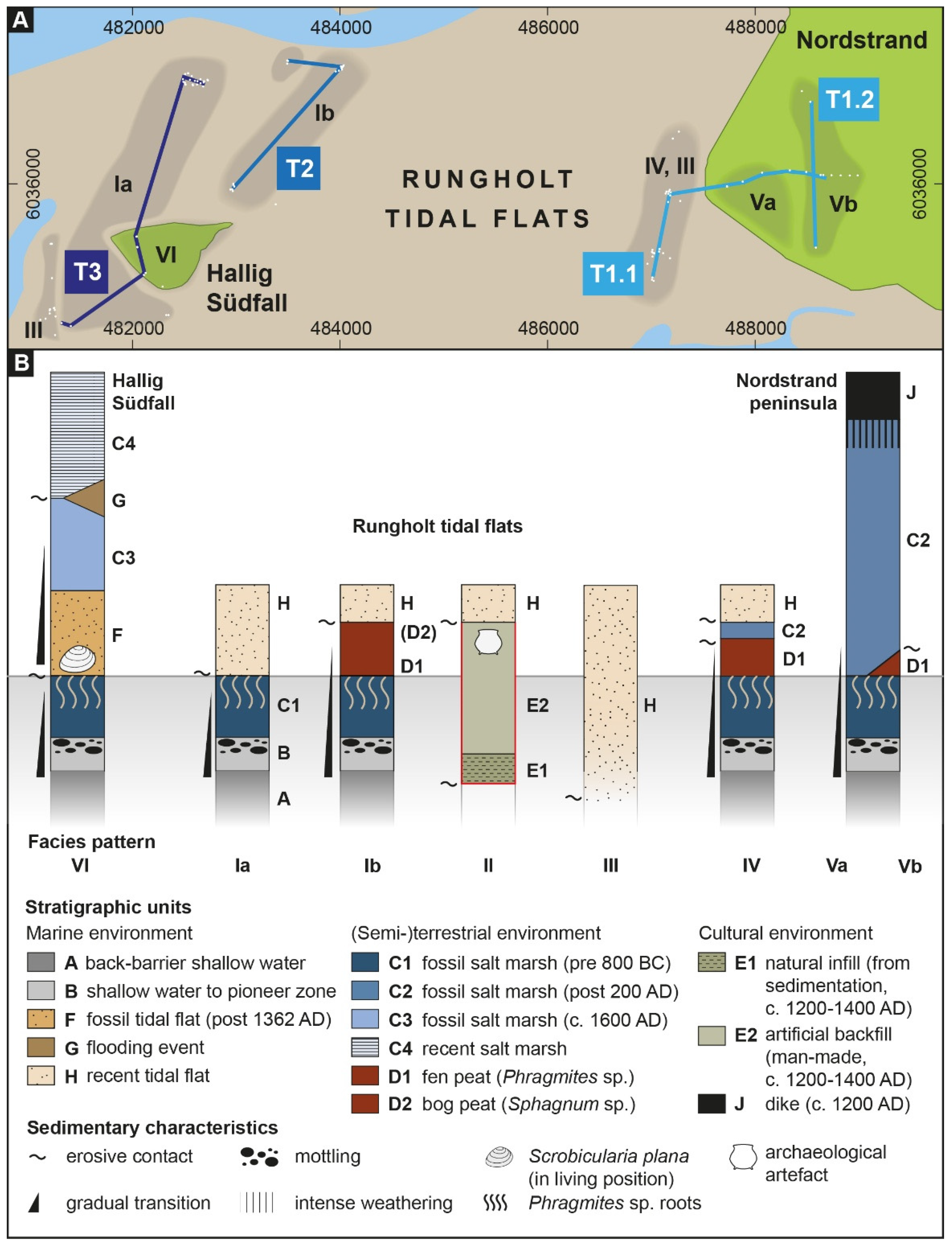
4.1. From Natural Coastal Dynamics

Sediment cores are arranged in three transects (Figure 1B, Figure 4, T1–3). Despite a maximum distance of 8 km (E–W) and 3 km (N–S) between some coring sites, all cores show an identical lower section indicating uniform environmental conditions (Figure 3, units A–C1): Across the entire study area (Figure 4, T1–T3), we found a shallow water lagoon-like back barrier environment (unit A) that dominated the coastal landscape. Constant siltation then gradually formed a pioneer zone (unit B) and subsequent salt marsh environment (unit C1), marked by a typical microfaunal assemblage, including Entzia macrescens and/or Trochammina sp. [20,60,68]. Around 800 BC (Figure 4, Table S3), the gradual development of reed swamps marks the onset of extensive fenland formation (unit D1) across most of the study area. Today, reed peat (unit D1) and (even rarer) bog peat (unit D2) is only locally preserved (Figure 3, facies patterns Ib, IV and Vb), mostly as ‘footprints’ below artificial structures like terps or dikes and with a maximum thickness of 1 m (e.g., Figure 4, T2, RUN 59A/62A or RUN 71A/95A, cf. [60]). More often, evidence of extensive peat formation is found in the form of numerous Phragmites sp. roots that still run vertically through the underlying salt marsh (unit C1) and thus prove a former superimposed fenland (e.g., Figure 3, facies pattern Ia, Figure 4, T3, RUN 37A or RUN 55A, cf. [18]). It is only along T1 that peat formation is partly limited to a local depression (Figure 3, facies pattern Vb, Figure 4, T1.2) or totally missing (Figure 3, facies pattern Va, Figure 4, T1.1, TRE 25A, 26A, 37A, 38A).
Our results show that the facies patterns become more differentiated from the 1st millennium AD onwards. Along T2 in the western study area, we find evidence for a shift from fen (unit D1) to bog (unit D2) formation around 500 AD, with the latter continuing at least until 1000 AD (Table S3, Figure 4, T2, RUN 95A). Along T1 in the eastern study area, we observe the development of salt marshes (unit C2) from c. 200 AD onwards (Figure 4, T1.1, e.g., TRE 16A, 33A, Table S3, cf. [67,68]), overlying eroded peat (unit D1), the upper boundary of which dates to c. 350–100 BC. At sites without any evidence of peat formation (Figure 4, T1.1, TRE 25A, 26A, 37A, 38A), we observe (salt) marsh conditions that prevailed from at least 800 BC until the embankment around c. 1200 AD (Figure 4, T1.1, TRE 2A, cf. [20,67]).
Figure 4. Stratigraphic cross sections of the Nordstrand peninsula ((T1.1,T1.2), cores TRE) and Rungholt tidal flats ((T2,T3), cores RUN) with archaeological context provided by previous research [35,60,67] following the ‘type case’ approach (cf. Figure 2). Dating results are arranged by context, depending on what natural (black) or cultural (blue) landscape elements they date (inverse ages excluded from interpretation are marked grey; see Table S3 for a detailed overview of dating results, * local reservoir correction [104], ** [62]).
Geosciences 15 00001 g004

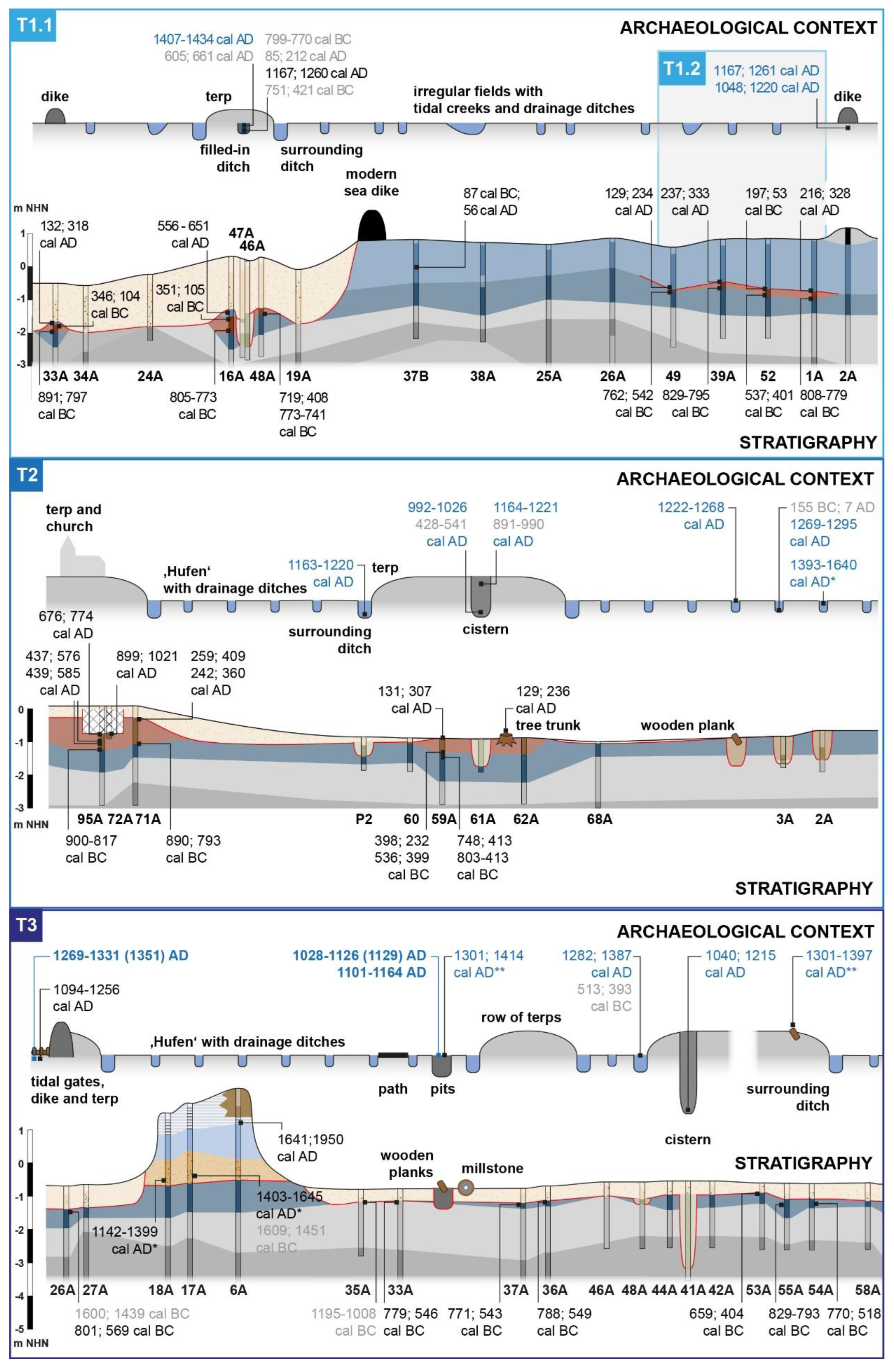
4.2. Towards a Cultural Landscape

Sedimentary evidence of cultivation and settlement is mostly preserved as natural infill (residual deposits, unit E1) or artificial backfill (waste deposits, unit E2) of human-made sediment traps, like drainage ditches, ponds used for watering livestock (‘Fething’ [47]), pits or sod cisterns (e.g., Figure 4, T1.1, TRE 46A, T2, RUN 61A or T3, RUN 41A). Radiocarbon dating of fillings (Figure 4, T1–3, Table S3), dendrochronological ages from timber (Figure 4, T3, Table S4) and archaeological finds (cf. [56,62]) date all investigated elements of the cultural landscape consistently to the period from the 12th to 14th cent. AD.
Moreover, remains of a building foundation associated with the church of Rungholt were found (Figure 4, T2, RUN 95A, brick-like slags and shell debris, cf. [60]). However, medieval coastal infrastructure (e.g., terps, dikes) can only be traced as ‘footprints’ in the local stratigraphy, i.e., inelastic deformations and compaction of underlying strata caused by the superimposed load of dikes and terps (Figure 4, T2, cf. [56,59]). We also observed that the occurrence and abundance of (in situ) archaeological finds along the transects (e.g., pottery, wood or metal objects, bones and bricks) is closely linked to stratigraphy. Along T1, finds are known (cf. [62]) but are recently covered by up to 2 m of sediment (Figure 4, T1, unit H, TRE 19A, 24A). Further finds have either been eroded or are not accessible from the present ground surface. At a former terp site along T2 (Figure 4, RUN 59A, 62A), we found pre-medieval 200–300 AD reed peat (unit D1) with in situ tree trunks. Apart from this, the area is mostly void of find material. At the former terp sites along T3, in contrast, exposed pre-800 BC marsh deposits (Figure 4, RUN 36A, 37A, unit C1) hold a great number of artefacts preserved in pits and ditches but also embedded in the fossil marsh (unit C1).

4.3. Storm Surges and the Formation of Tidal Flats

Sedimentary evidence from the early modern period subsequent to the 1362 AD flood event is rarely preserved across the study area. Along T3, we found 15th cent. AD fossil tidal flat deposits (unit F) with individuals of Scrobicularia plana and Cerastoderma edule in living position preserved below Hallig Südfall (Figure 3, facies pattern VI). Directly overlying the pre-800 BC fossil marsh (unit C1), this contact marks a distinct hiatus in the local stratigraphy (Figure 4, T3, e.g., RUN 17A, 18A). Younger phases of salt marsh formation (units C3 and C4) complete the sequence to the top. Along T1, we found early modern sediments as artificial backfill in a ditch surrounding a medieval terp (Figure 3, facies pattern II, Figure 4, T1.1, TRE 46, 47, cf. [67]). Recent tidal flat deposits (unit H) with significant local variations in thickness (Figure 3, facies pattern III) mark the top in most of the study area’s stratigraphy.

5. Discussion

Within the Wadden Sea region, extensive land reclamation in North Frisia began rather late (e.g., [6,52]), because unfavourable natural conditions in the coastal lowlands seem to have prevented permanent settlements [49,50,51]. Our comprehensive stratigraphic dataset, for the first time, provides a robust spatio-temporal reconstruction of the coastal landscape in the Rungholt area at the threshold of medieval land reclamation and socio-economic rise (Figure 4 and Figure 5, cf. Auge 2016).
Archaeological and geoscientific evidence from this study consistently date the onset of large-scale cultivation in the Nordstrand and Südfall area c. to the 12th cent. AD (Ref. [62]; Figure 4, Table S3). Compared to other Wadden Sea regions (cf. [5,7]), first settlers faced rather unfavourable natural conditions. In the western study area, continuous bog formation until at least c. 1000 AD (Figure 4, T2, RUN 72A, 95A) excluded any marine influence and thus the formation of marshland, but instead implied extensive, hardly accessible wetlands (Figure 5A). While these fens and bogs seemed to also extend west and north (i.e., Pellworm and Nordstrandischmoor), we expect a broad transition zone from fens to lower marshes towards Nordstrand. There, the (natural) local absence of peat between the fossil pre-800 BC marsh (unit C1) and the younger post-200 AD salt marsh (unit C2, Figure 4, T1.1 [35,67]) suggests that at the onset of 800 BC fen formation, the salt marshes in the western Nordstrand area had already silted up slightly above the surroundings. The proximity of large tidal channels confirmed for the central Nordstrand area [35] then likely favoured the local formation of marshes (unit C2) throughout the 1st mill. AD. For the study area, there is so far no distinct knowledge on mean high water in medieval times [105], but the medieval ground surface is today still preserved around c. 0.75 m NN (Figure 6). So, the western Nordstrand marshes were likely one of the few areas with both fertile soils and natural protection from at least regular flooding in the otherwise peat-dominated medieval landscape and thus suitable for early embankment.
Across the entire Wadden Sea region, we frequently find mutual dependencies between the natural landscape (e.g., presence of salt marsh ridges or fens/bogs), specific cultivation measures and equally specific patterns of settlements and parcelling [5,6,50,106,107]. Hence, reconstructing local patterns in a cultural landscape can be a suitable proxy for human–environment interactions. Even in (early) modern times, natural conditions often determine the distribution and type of settlement (e.g., cultivation of bogs along Geest fringes in 19th century, ‘Fehnkolonisation’ [106]).
Across the Rungholt study area, our results reveal distinct relations between settlements and cultivation measures. Comparing reconstructed natural conditions and medieval settlement patterns (Figure 1C,D and Figure 4 [35,59,60,67]), we found the westernmost Nordstrand marshes—embanked around 1200 AD (Figure 4 and Figure 5B, T1 [35])—to be dominated by single terps and irregular field parcels (‘puzzle structure’), typical for high marshes (Figure 1D [106]). In contrast, different rows of terps with elongated parcels (‘Hufen’) and a dense drainage network dominate the fen and bog landscape around Hallig Südfall (Figure 1C). These settlements typically occur in wetlands, like lower marshes (‘Sietland’) or fens and bogs [106], where cultivation required great effort and massive interventions, i.e., by intense drainage and/or peat removal. Results for the Rungholt area thus fit well with the typical medieval way of coastal marsh- and fenland colonisation in the Wadden Sea region (cf., [6] for an overview).
In the Rungholt area, stratigraphic differences between the ‘Hufen’ settlement sites provide convincing evidence that human impact significantly increased as cultivation moved in a western, i.e., seaward, direction.
Along the SW-NE orientated, c. 3 km long row of, so far, 29 terps (Figure 1C, cf. [60]), both fen and bog peat (units D1 and D2) are preserved beneath several terp sites. This proves that they were built on top of the peat prior to or during cultivation (Figure 3, facies pattern Ib, Figure 4, T2, Figure 5C). So far, we have not found any evidence of these terps being aligned along a dike. Compared to (early) modern settlement patterns from similar environmental contexts, we expect the terp’s orientation to reflect the direction of fen and bog colonisation (cf. [106,107]).
Along the W-E orientated row of 9 terps (Figure 1B,C), evidence of peat is only preserved by remains of Phragmites sp. roots (Figure 3, facies pattern Ia, Figure 4, T3). Instead, we found abundant evidence of 12th–14th cent. AD occupation (cf. [60]) directly on top of the pre-800 BC fossil marshland (unit C1, Figure 5C). Similar results are also known for the Südfall area, e.g., in the form of ploughing traces directly on top of this fossil marsh.
With the peat (unit D1/2) missing (Figure 3, facies pattern Ia), the 12th–14th cent. AD row of terps and distinct traces of land use directly on top of the pre-800 BC fossil marsh (unit C1) mark a major stratigraphic gap of c. 2200 years. This striking hiatus not only proves medieval land reclamation to be accompanied by extensive peat extraction. Results also imply that cultivation at least locally led to an obviously complete removal of peat prior to terp construction (Figure 4 and Figure 5C, T1, T2).
In view of the natural conditions at the onset of cultivation (Figure 5A), the different settlement patterns (Figure 1C,D) and the westward increasing human impact by cultivation (Figure 5C), we assume that the (naturally) higher western Nordstrand marsh was the nucleus of medieval land reclamation in the Rungholt area. It is from here that the rows of terps and associated ‘Hufen’ cultivation extended westward into the fens and bogs around present-day Hallig Südfall. The chronological consistency of the oldest settlement remains all across the study area (Figure 4, Table S3) further suggests that the transformation from a natural to a cultural landscape took place quite fast, probably within the course of only a century.
The consequences of the devastating 1362 AD storm flood in North Frisia are well known from historical sources [48] and archaeological [50] and geoscientific evidence [20]. It seems without doubt that even in a period of increased storminess and probably also increased transgressive tendencies of the North Sea (cf. Section 1), the 1362 AD flood was an exceptional event for the entire Wadden Sea region. Despite some advanced coastal protection measures in the Rungholt area [58,59,71], dike failures and large-scale flooding were to be expected. It is rather the extensive drowning and permanent loss of land that is unique to North Frisia.
Previous studies (e.g., [33]) explain the massive inland reach of the 1362 AD storm surge to North Frisia’s geological setting, i.e., the event-related reactivation of Pleistocene channels after compaction of the Holocene sedimentary sequence. The influence of the palaeorelief on the advance of the North Sea into low-lying marshes is also evident for the Rungholt area [35] and adjacent regions (e.g., [34]). Yet, our present results underline the role of massive overexploitation of peat resources and the resulting significant lowering of the ground surface for the devastating effects of the AD 1362 storm flood (Figure 5).
Historical evidence already emphasises the low relief and amphibious conditions as a challenging aspect of daily life in North Frisia, even (or especially) after cultivation [108]. A low ground surface, likely in the range of MHW, and resulting problems of drainage are also inferred from archaeological evidence [65]. As both North Frisia and the medieval period still lack reliable sea level data [36,105], it is quite problematic to directly relate the cultivated medieval ground surface to the local mean sea level. Yet, our data allow an approximate estimate of the effects of the massive cultivation measures and especially the extraction of peat on the coastal vulnerability.
The most complete sequence of (compacted) fen and bog peat is c. 1 m thick and preserved below the recently discovered church of Rungholt (Figure 4, T2, RUN 78A, 95A, units D1 and D2). The upper (eroded) boundary lies at c. −0.5 m NHN. Further north, we found a c. 0.5 m thick peat sequence preserved below a terp (Figure 4, T2, RUN 59A, unit D1), with an upper (eroded) boundary exposed at the present ground surface at c. −0.9 m NHN. Considering these sequences as absolute minimum values for the thickness of the peat cover, and without considering the inevitable effects of peat compaction from the onload of the former building, we assume that medieval efforts of cultivation down to the fossil marshes (unit C1) below the fen- and bog-level (unit D) required the removal of peat in the range of at least 0.5 to 1 m (Figure 6). Due to the advanced state of erosion, reconstructing the pre-medieval wetland relief is almost impossible. Yet, Sphagnum sp. mosses (unit D2) provide an upper limiting point and imply that the original ground surface locally lay above the local ground water table and (in a coastal region) above the mean sea level.
Even without reconstructing the local relief prior to cultivation, our results prove that the ground surface of the study area was lowered below the MHW of 1362 AD by human overexploitation (Figure 6): The fossil marsh (unit C1) and, thus, the cultivated medieval ground surface is best preserved below Südfall at c. −0.6 m NHN (without considering some subsidence by compaction since the formation and thus load of the Hallig). Here, marine sediments with abundant specimens of Scrobicularia plana and also Cerastoderma edule in living position were found directly on top of the drowned fossil marshland (Figure 4, T3, unit F, cf. [35,109]). Dating to c. 1400 AD (Figure 4, T3, Table S3), these intertidal species prove that tidal flats developed almost immediately after the event.
Conclusively, the ground surface of the cultivated marshes in the Rungholt area must have already been below the MHW level at the time of the devastating 1362 AD flood. As renewed marsh formation began at c. 0.00 to 0.25 m NHN (Figure 4, T3, unit C3, Table S3) within the two following centuries, we expect this height to be the upper range for the mean high water in 1362 AD. Radiocarbon dating (Figure 4, T3, RUN 6A, cf. [20]) and historical reports on c. 1600 AD re-embankment plans for the Rungholt tidal flats [110] provide a time span of about 200 years for the prevalence of post-1362 AD tidal flat conditions in the Rungholt area and a natural return to a salt marsh environment. Only the elevated marshes of western Nordstrand survive the 1362 AD event. Here, we found artificial backfill in drainage ditches as evidence of post-1362 AD terp enlargement and thus ongoing settlement activity [67]. The AD 1634 Burchardi flood then interrupted the renewed marsh formation in most of the study area and finally established today’s tidal flats.

Supplementary Materials

The following supporting information can be downloaded at: https://www.mdpi.com/article/10.3390/geosciences15010001/s1, Table S1: Core background data; Table S2: Stratigraphic units of the Rungholt study area; Table S3: Radiocarbon dating results; Table S4: Dendrochronological dating results [111].

Author Contributions

Conceptualisation, H.H. and A.V.; data curation, H.H., A.R. and T.W., formal analysis, H.H. and A.R., methodology, H.H., D.W., R.B. and B.M.; investigation, H.H., T.W., A.R., D.W., R.B., B.M. and S.K.; resources, A.V. and H.H.; data curation, H.H.; writing—original draft preparation, H.H.; writing—review and editing, A.R., A.V., D.W. and T.W.; visualisation, H.H.; supervision, H.H.; project administration, H.H.; funding acquisition, H.H., A.V., D.W., U.I. and R.B. All authors have read and agreed to the published version of the manuscript.

Funding

This research was funded by the Deutsche Forschungsgemeinschaft (German Research Foundation) (grant numbers CA 146/22-1, HA 7647/1-1 and 3-1, IC 85/3-1, VO 938/21-1 and 31-1, WI 4074/7-1; project numbers 275401547 and 442822276).

Data Availability Statement

The data presented in this study are available on request from the corresponding author due to cultural heritage reasons.

Acknowledgments

Working permits were kindly issued by the Schleswig-Holstein State Office for Coastal Protection, National Park and Marine Protection (Landesbetrieb für Küstenschutz, Nationalpark und Meeresschutz, Schleswig-Holstein) and the State Archaeology Department Schleswig-Holstein (Archäologisches Landesamt Schleswig-Holstein). The authors are greatly indebted to Gunda and Gonne Erichsen, Hallig Südfall, for transportation and logistic support during fieldwork, the Nordstrand farmers for their support and permission to work on their arable land and Yvonne and Martin Thormählen for their always open hospitality.

Conflicts of Interest

The authors declare no conflicts of interest.

References

  1. Behre, K.-E. New Holocene sea-level curve for the southern North Sea. Boreas 2007, 36, 82–102. [Google Scholar] [CrossRef]
  2. Bakker, M. The nature and dynamics of pre-Roman Iron Age and Roman Iron Age reclamation settlements in the (former) peat and clay-on-peat area of Friesland (The Netherlands). J. Wetl. Archaeol. 2022, 22, 7–29. [Google Scholar] [CrossRef]
  3. Bakker, M.; de Langen, G. Peat reclamations of the pre-Roman Iron Age and Roman Iron Age: Drainage ditch systems and settlement patterns in the province of Friesland, the Netherlands. Palaeohistoria 2023, 63, 57–145. [Google Scholar] [CrossRef]
  4. UNESCO (United Nations Educational, Scientific and Cultural Organisation) 33 COM 8B.4—Decision. Available online: https://whc.unesco.org/en/decisions/1946/ (accessed on 5 November 2024).
  5. Bazelmans, J.; Meier, D.; Nieuwhof, A.; Spek, T.; Vos, P. Understanding the cultural historical value of the Wadden Sea region. The co-evolution of environment and society in the Wadden Sea area in the Holocene up until early modern times (11,700 BC–1800 AD): An outline. Ocean. Coast. Manag. 2012, 68, 114–126. [Google Scholar] [CrossRef]
  6. Vollmer, M.; Guldberg, M.; Maluck, M.; van Marrewijk, D.; Schlicksbier, G. Landscape and Cultural Heritage in the Wadden Sea Region—Project Report. In Wadden Sea Ecosystem No. 12; Common Wadden Sea Secretariat: Wilhelmshaven, Germany, 2001; p. 336. [Google Scholar]
  7. Nieuwhof, A.; Jöns, H.; de Langen, G.; Nicolay, J.; Siegmüller, A. Leben mit dem Meer: Terpen, Wierden und Wurten/Leven met de zee: Terpen, wierden en wurten. In Land der Entdeckungen. Die Archäologie des Friesischen Küstenraums/Land van Ontdekkingen. de Archeologie van het Friese Kustgebied; Nieuwhof, A., Nowak-Klimscha, K., Reimann, H., Eds.; Ostfriesische Landschaftliche Verlags- und Vertriebsgesellschaft mbH: Aurich, Germany, 2013; pp. 146–155. ISBN 978-3-940601-16-2. [Google Scholar]
  8. Nieuwhof, A.; Bakker, M.; Knol, E.; de Langen, G.J.; Nicolay, J.A.W.; Postma, D.; Schepers, M.; Varwijk, T.W.; Vos, P.C. Adapting to the sea: Human habitation in the coastal area of the northern Netherlands before medieval dike building. Ocean. Coast. Manag. 2019, 173, 77–89. [Google Scholar] [CrossRef]
  9. Pierik, H.J. Landscape changes and human–landscape interaction during the first millennium AD in The Netherlands. Neth. J. Geosci. 2021, 100, e11. [Google Scholar] [CrossRef]
  10. Kühn, H.J.; Panten, A. Der Frühe Deichbau in Nordfriesland: Archäologisch-Historische Untersuchungen, 2nd ed.; Nordfriisk Inst: Bräist/Bredstedt, Germany, 1995; ISBN 978-3-88007-158-2. [Google Scholar]
  11. Behre, K.-E. Landscape development and occupation history along the southern North Sea coast. In Climate Development and History of the North Atlantic Realm: With 16 Tables; Wefer, G., Berger, W.H., Behre, K.-E., Jansen, E., Eds.; Springer: Berlin/Heidelberg, Germany, 2002; pp. 299–312. ISBN 978-3-540-43201-2. [Google Scholar]
  12. Knottnerus, O.S. History of human settlement, cultural change and interference with the marine environment. Helgol. Mar. Res. 2005, 59, 2–8. [Google Scholar] [CrossRef]
  13. Jensen, J.; Müller-Navarra, S.H. Storm surges on the German coast. Küste-Arch. Forsch. Tech. Nord. Ostsee 2008, 74, 92–124. [Google Scholar]
  14. Newig, J.; Kelletat, D. The North Sea Tsunami of 5 June 1858. J. Coast. Res. 2011, 276, 931–941. [Google Scholar] [CrossRef]
  15. Newig, J. Historische „Seebären“/Meteotsunamis an den deutschen Küsten—Mit einem Schwerpunkt Sylt. In Aktuelle Küstenforschung an der Nordsee; Tillmann, T., Ed.; Coastline Reports EUCC: Wilhelmshaven, Germany, 2015; Volume 25, pp. 87–103. ISBN 978-3-939206-18-7. [Google Scholar]
  16. Lamb, H.H. Historic Storms of the North Sea, British Isles, and Northwest Europe; Cambridge University Press: Cambridge, UK, 1991; p. 204. ISBN 978-0-521-37522-1. [Google Scholar]
  17. Behre, K.-E. Landschaftsgeschichte Norddeutschlands: Umwelt und Siedlung von der Steinzeit bis zur Gegenwart; Wachholtz: Neumünster, Germany, 2008; p. 308. ISBN 978-3-529-02499-3. [Google Scholar]
  18. Fruergaard, M.; Andersen, T.J.; Johannessen, P.N.; Nielsen, L.H.; Pejrup, M. Major coastal impact induced by a 1000-year storm event. Sci. Rep. 2013, 3, 1051. [Google Scholar] [CrossRef]
  19. Stewart, H.; Bradwell, T.; Bullard, J.; Davies, S.J.; Golledge, N.; McCulloch, R.D. 8000 years of North Atlantic storminess reconstructed from a Scottish peat record: Implications for Holocene atmospheric circulation patterns in Western Europe. J. Quat. Sci. 2017, 32, 1075–1084. [Google Scholar] [CrossRef]
  20. Hadler, H.; Vött, A.; Willershäuser, T.; Wilken, D.; Blankenfeldt, R.; Carnap–Bornheim, C.; Emde, K.; Fischer, P.; Ickerodt, U.; Klooß, S.; et al. Automated facies identification by Direct Push–based sensing methods (CPT, HPT) and multivariate linear discriminant analysis to decipher geomorphological changes and storm surge impact on a medieval coastal landscape. Earth Surf. Process. Landf. 2021, 46, 3228–3251. [Google Scholar] [CrossRef]
  21. Hess, K.; Engel, M.; Patel, T.; Vakhrameeva, P.; Koutsodendris, A.; Klemt, E.; Hansteen, T.H.; Kempf, P.; Dawson, S.; Schön, I.; et al. A 1500-year record of North Atlantic storm flooding from lacustrine sediments, Shetland Islands (UK). J. Quat. Sci. 2024, 39, 37–53. [Google Scholar] [CrossRef]
  22. Petersen, M.; Rohde, H. Sturmflut. Die Großen Fluten an den Küsten Schleswig-Holsteins und in der Elbe, 3rd ed.; Wachholtz Verlag: Neumünster, Germany, 1977; p. 148. ISBN 3-529-06163-8. [Google Scholar]
  23. Ehlers, J. Die Nordsee: Vom Wattenmeer zum Nordatlantik; Wissenschaftliche Buchgesellschaft: Darmstadt, Germany, 2008; p. 176. ISBN 978-3-89678-638-8. [Google Scholar]
  24. FWU—Forschungsinstitut Wasser und Umwelt, Universität Siegen Kleine Dokumentation Historischer Sturmfluten. 2019. Available online: https://www.bau.uni-siegen.de/fwu/wb/publikationen/sturmflutarchiv/ (accessed on 6 November 2024).
  25. van Popta, Y.T.; Cohen, K.M.; Vos, P.C.; Spek, T.H. Reconstructing medieval eroded landscapes of the North-Eastern Zuyder Zee (the Netherlands): A refined palaeogeographical time series of the Noordoostpolder between a.d. 1100 and 1400. Landsc. Hist. 2020, 41, 27–56. [Google Scholar] [CrossRef]
  26. Streif, H. Sedimentary record of Pleistocene and Holocene marine inundations along the North Sea coast of Lower Saxony, Germany. Quat. Int. 2004, 112, 3–28. [Google Scholar] [CrossRef]
  27. Newig, J. Nordfrieslands Küste zwischen Landgewinn und Landverlust. Geogr. Rundsch. 2014, 66, 4–13. [Google Scholar]
  28. Trouet, V.; Esper, J.; Graham, N.E.; Baker, A.; Scourse, J.D.; Frank, D.C. Persistent Positive North Atlantic Oscillation Mode Dominated the Medieval Climate Anomaly. Science 2009, 324, 78–80. [Google Scholar] [CrossRef]
  29. Trouet, V.; Scourse, J.D.; Raible, C.C. North Atlantic storminess and Atlantic Meridional Overturning Circulation during the last Millennium: Reconciling contradictory proxy records of NAO variability. Glob. Planet. Chang. 2012, 84, 48–55. [Google Scholar] [CrossRef]
  30. Baker, A.; Hellstrom, J.C.; Kelly, B.F.J.; Mariethoz, G.; Trouet, V.A. Composite annual-resolution stalagmite record of North Atlantic climate over the last three millennia. Sci. Rep. 2015, 5, 10307. [Google Scholar] [CrossRef]
  31. Orme, L.C.; Reinhardt, L.; Jones, R.T.; Charman, D.J.; Barkwith, A.; Ellis, M.A. Aeolian sediment reconstructions from the Scottish Outer Hebrides: Late Holocene storminess and the role of the North Atlantic Oscillation. Quat. Sci. Rev. 2016, 132, 15–25. [Google Scholar] [CrossRef]
  32. Meeker, L.D.; Mayewski, P.A. A 1400-year high-resolution record of atmospheric circulation over the North Atlantic and Asia. Holocene 2002, 12, 257–266. [Google Scholar] [CrossRef]
  33. Hoffmann, D. Das Küstenholozän im Einzugsbereich der Norderhever, Nordfriesland. In Das Norderhever-Projekt 1. Landschaftsentwicklung und Besiedlungsgeschichte im Einzugsgebiet der Norderhever; Müller-Wille, M., Higelke, B., Hoffmann, D., Menke, B., Brande, A., Bokelmann, K., Saggau, H.E., Kühn, H.J., Eds.; Karl Wachholtz Verlag: Neumünster, Germany, 1988; pp. 51–115. [Google Scholar]
  34. Karle, M.; Bungenstock, F.; Wehrmann, A. Holocene coastal landscape development in response to rising sea level in the Central Wadden Sea Coastal Region. Neth. J. Geosci. 2021, 100, e12. [Google Scholar] [CrossRef]
  35. Hadler, H.; Wilken, D.; Bäumler, S.; Fischer, P.; Rabbel, W.; Willershäuser, T.; Wunderlich, T.; Vött, A. The Trendermarsch polder (North Frisia, Germany)—Geophysical and geoarchaeological investigations of an anthropogenic medieval coastal landscape and its vulnerability against natural hazards. Geomorphology 2022, 418, 108461. [Google Scholar] [CrossRef]
  36. Scheder, J.; Bungenstock, F.; Haynert, K.; Pint, A.; Schlütz, F.; Frenzel, P.; Wehrmann, A.; Brückner, H.; Engel, M. Insights into Holocene relative sea-level changes in the southern North Sea using an improved microfauna-based transfer function. J. Quat. Sci. 2022, 37, 71–85. [Google Scholar] [CrossRef]
  37. Hoffmann, D. Landschafts- und Siedlungsgeschichte im Bereich der heutigen Marscheninseln und Watten Nordfrieslands. A. Geologische Untersuchungen. In Siedlungsforschung. Archäologie-Geschichte-Geographie Band 2; Fehn, K., Brandt, K., Denecke, D., Irsigler, F., Janssen, W., Krings, W., Lüning, J., Müller-Wille, M., Nitz, H.-J., Oberbeck, G., et al., Eds.; Verlag Siedlungsforschung: Bonn, Germany, 1984; pp. 165–172. [Google Scholar]
  38. Soens, T. Threatened by the Sea, Condemned by Man? Flood Risk and Environmental Inequalities along the North Sea Coast, 1200-1800. In Environmental and Social Justice in the City: Historical Perspectives; Massard-Guilbaud, G., Rodger, R., Eds.; The White Horse Press: Cheshire, UK, 2011; pp. 91–111. ISBN 978-1-912186-33-4. [Google Scholar]
  39. Soens, T. The origins of the Western Scheldt. Environmental transformation, storm surges and human agency in the Flemish coastal plain (1250–1600). In Landscapes or Seascapes? The History of the Coastal Environment in the North Sea Area Reconsidered; Thoen, E., Borger, G.J., De Kraker, A.M.J., Soens, T., Tys, D., Vervaet, L., Weerts, H.J.T., Eds.; Brepols Publishers: Turnhout, Belgium, 2013; pp. 287–312. ISBN 978-2-503-54695-7. [Google Scholar]
  40. Knottnerus, O.S. Reclamations and submerged lands in the Ems River estuary (900–1500). In Landscape or Seascape? The History of the Coastal Environment in the North Sea Area Reconsidered; Thoen, E., Borger, G.J., De Kraker, A.M.J., Soens, T., Tys, D., Vervaet, L., Weerts, H.J.T., Eds.; Brepols Publishers: Turnhout, Belgium, 2013; Volume 13, pp. 241–266. ISBN 978-2-503-54058-0. [Google Scholar]
  41. de Langen, G. De gang naar een ander landschap. De ontginning van de (klei-op-)veengebieden in Fryslân gedurende de late ijzertijd, Romeinse tijd en middeleeuwen (van ca. 200 v. Chr. tot ca. 1200 na Chr.). In Gevormd en Omgevormd Landschap. Van Prehistorie tot Middeleeuwen; Niekus, M.J.L.T.H., van der Zee, S., Looijenga, T., Kiestra, F., Eds.; Drents Prehistorische Vereniging: Assen, The Netherlands, 2011; pp. 70–97. [Google Scholar]
  42. Vos, P.C.; Knol, E. Holocene landscape reconstruction of the Wadden Sea area between Marsdiep and Weser: Explanation of the coastal evolution and visualisation of the landscape development of the northern Netherlands and Niedersachsen in five palaeogeographical maps from 500 BC to present. Neth. J. Geosci. 2015, 94, 157–183. [Google Scholar] [CrossRef]
  43. Knol, E.; Vos, P.C. Lauwerzee. In Fragmenten uit de Rijke Wereld van de Archeologie: Opgedragen aan Ernst Taayke Bij Zijn Afscheid als Beheerder van het Noordelijk Archeologisch Depot in Nuis; Nieuwhof, A., Knol, E., Schokker, J., Arnoldussen, S., Van den Broeke, P.W., Burie-Gotink, A., Taayke, E., Eds.; Jaarverslagen van de Vereniging voor Terpenonderzoek: Groningen, The Netherlands, 2018; pp. 157–168. ISBN 978-90-811714-9-6. [Google Scholar]
  44. Marschallek, K.H. Die Salzgewinnung an der friesischen Nordseeküste. In Probleme der Küstenforschung im Südlichen Nordseegebiet; Isensee Verlag: Oldenburg, Germany, 1974; Volume 10, pp. 127–146. [Google Scholar]
  45. Siegmüller, A.; Bungenstock, F. Salztorfabbau im Jadebusengebiet. Prospektion von anthropogenen Landabsenkungen und ihren Folgen. Nachrichten Aus Niedersachs. Urgesch. 2010, 79, 201–220. [Google Scholar] [CrossRef]
  46. Majchczack, B.S.; Blankenfeldt, R.; Bienen-Scholt, D.; Hadler, H.; Jürgens, F.; Klooß, S.; Reiß, A.; Wilken, D.; von Carnap-Bornheim, C.; Rabbel, W.; et al. Living on the Halligen tidal islands of North Frisia. Land-use and exploitation of a unique salt marsh landscape in the Middle Ages. In Making Places, Making Lives. Landscape and Settlement in Coastal Wetlands, Proceedings of the 72th Sachsensymposion, Alkmaar, The Netherlands, 9–12 October 2021; Nieuwhof, A., Knol, E., van der Velde, H., Eds.; Uwe Krebs: Wendeburg, Germany, 2024; p. 2024. [Google Scholar]
  47. Rieken, B. Nordsee ist Mordsee. Sturmfluten und ihre Bedeutung für die Mentalitätsgeschichte der Friesen; Waxmann: Münster, Germany, 2005; p. 456. ISBN 978-3-8309-1499-0. [Google Scholar]
  48. Fouquet, G.; Zeilinger, G. Katastrophen im Spätmittelalter; von Zabern, P., Ed.; Von Zabern Verlag: Darmstadt, Germany, 2011; p. 172. ISBN 978-3-8053-4362-6. [Google Scholar]
  49. Bantelmann, A. Die Landschaftsentwicklung im nordfriesischen Küstengebiet. Eine Funktionschronik durch fünf Jahrtausende. Die Küste 1967, 14, 5–99. [Google Scholar]
  50. Kühn, H.J. Jenseits der Deiche. Archäologie im nordfriesischen Wattenmeer. In Es War Einmal Ein Schiff; von Carnap-Bornheim, C., Radtke, C., Eds.; Marebuchverlag: Hamburg, Germany, 2007; pp. 251–284. ISBN 978-3-86648-053-7. [Google Scholar]
  51. Hoffmann, D. Holocene landscape development in the marshes of the West Coast of Schleswig-Holstein, Germany. Quat. Int. 2004, 112, 29–36. [Google Scholar] [CrossRef]
  52. Auge, O. Die Nordfriesischen Utlande und König Waldemar II. der Sieger (Sejr) von Dänemark. In Rungholt. Rätselhaft und Widersprüchlich; Newig, J., Haupenthal, U., Eds.; Husum Druck- und Verlagsgesellschaft: Husum, Germany, 2016; pp. 37–40. ISBN 978-3-89876-824-5. [Google Scholar]
  53. Meier, D. Man and environment in the marsh area of Schleswig–Holstein from Roman until late Medieval Times. Quat. Int. 2004, 112, 55–69. [Google Scholar] [CrossRef]
  54. Eversberg, G. Die Rungholtsage. Nord. Kunst-Und Kult. Gesch. Schleswig-Holst. 2005, 74, 113–143. [Google Scholar]
  55. Ickerodt, U. Was ist Kryptoarchäologie? Von Rungholt und anderen Lost Worlds. In Archäologische Nachrichten aus Schleswig-Holstein; Archäologisches Landesamt Schleswig-Holstein (ALSH), Ed.; Wachholtz Verlag: Kiel, Germany, 2016; Volume 22, pp. 142–149. ISBN 978-3-529-01438-3. [Google Scholar]
  56. Majchczack, B.S.; Klooß, S.; Hadler, H.; Wilken, D.; Blankenfeldt, R. Mehr als Rungholt. Spurensuche im nordfriesischen Wattenmeer. In Zeitreise unter Wasser. Spektakuläre Entdeckungen zwischen Ostsee und Bodensee; Huber, F., Ed.; Theiss in Herder: Hamburg, Germany, 2021; pp. 116–129. ISBN 978-3-8062-4350-5. [Google Scholar]
  57. Blankenfeldt, R.; Klooß, S.; Hadler, H.; Majchczack, B.S.; Wilken, D.; Bienen-Scholt, D. Versunkene Landschaften im Nordfriesischen Watt—Das aktuelle RUNGHOLT-Projekt zur Erforschung von Kulturspuren. In Arkæologi i Slesvig Symposium Christianslyst 17.-18.6.2022; Klooß, S., Kruse, P., Lütjens, I., Eds.; Wachholtz Verlag: Haderslev, Danmark, 2023; Volume 19, pp. 59–74. ISBN 978-87-87584-39-5. [Google Scholar]
  58. Busch, A. Die Entdeckung der letzten Spuren Rungholts. Jahrb. Nord. Für Heimatkunde Heimatliebe 1923, 10, 1–32. [Google Scholar]
  59. Wilken, D.; Hadler, H.; Wunderlich, T.; Majchczack, B.S.; Schwardt, M.; Fediuk, A.; Fischer, P.; Willershäuser, T.; Klooß, S.; Vött, A.; et al. Lost in the North Sea-Geophysical and geoarchaeological prospection of the Rungholt medieval dyke system (North Frisia, Germany). PLoS ONE 2022, 17, e0265463. [Google Scholar] [CrossRef] [PubMed]
  60. Wilken, D.; Hadler, H.; Majchczack, B.S.; Blankenfeldt, R.; Auge, O.; Bäumler, S.; Bienen-Scholt, D.; Ickerodt, U.; Klooß, S.; Reiß, A.; et al. The discovery of the church of Rungholt, a landmark for the drowned medieval landscapes of the Wadden Sea World Heritage. Sci. Rep. 2024, 14, 15576. [Google Scholar] [CrossRef]
  61. Hadler, H.; Vött, A. Der Handelsplatz Rungholt und seine Zerstörung durch die 1. Grote Mandrenke im Jahr 1362. Geogr. Rundsch. 2017, 69, 20–25. [Google Scholar]
  62. Kühn, H.J. Die archäologischen Funde aus dem Rungholt-Watt. In Rungholt. Rätselhaft und Widersprüchlich; Newig, J., Haupenthal, U., Eds.; Husum Druck- und Verlagsgesellschaft: Husum, Germany, 2016; pp. 125–166. ISBN 978-3-89876-824-5. [Google Scholar]
  63. Hadler, H.; Wilken, D.; Wunderlich, T.; Fediuk, A.; Fischer, P.; Schwardt, M.; Willershäuser, T.; Rabbel, W.; Vött, A. Drowned by the Grote Mandrenke in 1362: New geo-archaeological research on the late medieval trading centre of Rungholt (North Frisia). In Waddenland Outstanding: History, Landscape and Cultural Heritage of the Wadden Sea Region; Egberts, L., Schroor, M., Eds.; Amsterdam University Press: Amsterdam, The Netherlands, 2018; pp. 239–251. ISBN 978-90-485-3788-4. [Google Scholar]
  64. Higelke, B. Das Norderhever-Projekt. Beiträge zur Landschafts- und Siedlungsgeschichte der nordfriesischen Marschen und Watten. Besiedlungs- und jüngere Landschaftsgeschichte. Geographische Untersuchungen. Offa—Berichte Mitteilungen Urgesch. Frühgeschichte Mittelalt. 1982, 39, 261–270. [Google Scholar]
  65. Busch, A. Zur Rekonstruktion der Rungholter Schleusen. Die Heim. 1963, 70, 163–168. [Google Scholar]
  66. Newig, J.; Haupenthal, U. (Eds.) Rungholt. Rätselhaft und Widersprüchlich; Husum Druck- und Verlagsgesellschaft: Husum, Germany, 2016; p. 174. ISBN 978-3-89876-824-5. [Google Scholar]
  67. Reiß, A.; Hadler, H.; Wilken, D.; Majchczack, B.S.; Blankenfeldt, R.; Bäumler, S.; Ickerodt, U.; Klooß, S.; Willershäuser, T.; Rabbel, W.; et al. The Trendermarsch sunken in the Wadden Sea (North Frisia, Germany)—Reconstructing a drowned medieval cultural landscape by geoarchaeological and geophysical investigations. EG Quat. Sci. J. 2024. [Google Scholar]
  68. Reiß, A.; Hadler, H.; Wilken, D.; Majchczack, B.; Blankenfeldt, R.; Ickerodt, U.; Klooß, S.; Rabbel, W.; Willershäuser, T.; Vött, A. Geoarchaeological and geophysical investigations in the tidal flats of the Trendermarsch, Nordstrand (North Frisia, Germany). ZfG-Z. Geomorphol. 2024, epub ahead of printing. [Google Scholar] [CrossRef]
  69. Ad-hoc. In AG Boden Bodenkundliche Kartieranleitung, 5th ed.; Schweizerbart sciences publisher: Hannover, Germany, 2005; p. 438.
  70. Schrott, L. Gelände-Arbeitsmethoden in der Geomorphologie. In Einführung in die Geomorphologie; Ahnert, F., Ed.; UTB: Stuttgart, Germany, 2015; pp. 396–413. ISBN 978-3-8383-8627-4. [Google Scholar]
  71. Hadler, H.; Vött, A.; Newig, J.; Emde, K.; Finkler, C.; Fischer, P.; Willershäuser, T. Geoarchaeological evidence of marshland destruction in the area of Rungholt, present-day Wadden Sea around Hallig Südfall (North Frisia, Germany), by the Grote Mandrenke in 1362 AD. Quat. Int. 2018, 473, 37–54. [Google Scholar] [CrossRef]
  72. Köhn, M. Korngrößenanalyse vermittels Pipettanalyse. Tonind.-Ztg. 1929, 53, 729–731. [Google Scholar]
  73. Blume, H.-P.; Stahr, K.; Leinweber, P. Bodenkundliches Praktikum: Eine Einführung in Pedologisches Arbeiten für Ökologen, Land- und Forstwirte, Geo- und Umweltwissenschaftler, 3rd ed.; Spektrum Akademischer Verlag: Heidelberg, Germany, 2011; p. 255. ISBN 978-3-8274-1553-0. [Google Scholar]
  74. Blott, S.J.; Pye, K. GRADISTAT: A grain size distribution and statistics package for the analysis of unconsolidated sediments. Earth Surf Process. Landf 2001, 26, 1237–1248. [Google Scholar] [CrossRef]
  75. Schmidt, W.; Scheibner, H. Zur Bestimmung des Gehaltes an organischer Substanz von Torfen und Mudden. Arch. Acker Pflanzenbau Bodenkd. 1988, 32, 423–433. [Google Scholar]
  76. Barsch, H. Geoökologische Bewertung der Befunde. In Arbeitsmethoden in Physiogeographie und Geoökologie; Barsch, H., Billwitz, K., Bork, H.-R., Eds.; Klett-Perthes: Gotha, Germany, 2000; pp. 451–496. ISBN 978-3-623-00848-6. [Google Scholar]
  77. Dearing, J.; Hay, K.L.; Baban, S.M.J.; Huddleston, A.S.; Wellington, E.M.H.; Loveland, P.J. Magnetic susceptibility of soil: An evolution of conflicting theories using a national data set. Geophys. J. Int. 1996, 127, 728–734. [Google Scholar] [CrossRef]
  78. Evans, M.E.; Heller, F. Environmental Magnetism—Principles and Applications of Enviromagnetics; Academic Press: San Diego, CA, USA, 2003; p. 299. ISBN 0-12-243851-5. [Google Scholar]
  79. Hanesch, M.; Scholger, R. The influence of soil type on the magnetic susceptibility measured throughout soil profiles. Geophys. J. Int. 2005, 161, 50–56. [Google Scholar] [CrossRef]
  80. Goldberg, P.; Macphail, R.I. Practical and Theoretical Geoarchaeology; Wiley-Blackwell: Hoboken, NJ, USA, 2006; p. 463. ISBN 9781118688182. [Google Scholar]
  81. Mann, S.; Sparks, N.H.C.; Frankel, R.B.; Bazylinski, D.A.; Jannasch, H.W. Biomineralization of ferrimagnetic greigite (Fe3S4) and iron pyrite (FeS2) in a magnetotactic bacterium. Nature 1990, 343, 258–261. [Google Scholar] [CrossRef]
  82. Heywood, B.R.; Bazylinski, D.A.; Garratt-Reed, A.; Mann, S.; Frankel, R.B. Controlled biosynthesis of greigite (Fe3S4) in magnetotactic bacteria. Naturwissenschaften 1990, 77, 536–538. [Google Scholar] [CrossRef]
  83. Hilton, J. Greigite and the magnetic properties of sediments. Limnol. Oceanogr. 1990, 35, 509–520. [Google Scholar] [CrossRef]
  84. Stanjek, H.; Fassbinder, J.W.E.; Vali, H.; Wägele, H.; Graf, W. Evidence of biogenic greigite (ferrimagnetic Fe3S4) in soil. Eur. J. Soil Sci. 1994, 45, 97–103. [Google Scholar] [CrossRef]
  85. Wheeler, A.J.; Oldfield, F.; Orford, J.D. Depositional and Post–Depositional controls on magnetic signals from saltmarshes on the north–west coast of Ireland. Sedimentology 1999, 46, 545–558. [Google Scholar] [CrossRef]
  86. EPA—United States Environmental Protection Agency. Field Portable X-Ray Fluorescence Spectrometry for the Determination of Elemental Concentrations in Soil and Sediment. Available online: https://www.epa.gov/sites/default/files/2015-12/documents/6200.pdf (accessed on 11 November 2024).
  87. Chagué-Goff, C.; Goff, J.; Wong, H.K.Y.; Cisternas, M. Insights from geochemistry and diatoms to characterise a tsunami’s deposit and maximum inundation limit. Mar. Geol. 2015, 359, 22–34. [Google Scholar] [CrossRef]
  88. Chagué-Goff, C.; Szczuciński, W.; Shinozaki, T. Applications of geochemistry in tsunami research: A review. Earth-Sci. Rev. 2017, 165, 203–244. [Google Scholar] [CrossRef]
  89. Judd, K.; Chagué-Goff, C.; Goff, J.; Gadd, P.; Zawadzki, A.; Fierro, D. Multi-proxy evidence for small historical tsunamis leaving little or no sedimentary record. Mar. Geol. 2017, 385, 204–215. [Google Scholar] [CrossRef]
  90. Finkler, C.; Fischer, P.; Baika, K.; Rigakou, D.; Metallinou, G.; Hadler, H.; Vött, A. Tracing the Alkinoos Harbor of Ancient Kerkyra, Greece, and reconstructing its paleotsunami history. Geoarchaeology 2018, 33, 24–42. [Google Scholar] [CrossRef]
  91. Scott, D.B.; Hermelin, J.O.R. A Device for Precision Splitting of Micropaleontological Samples in Liquid Suspension. J. Paleontol. 1993, 67, 151–154. [Google Scholar] [CrossRef]
  92. Murray, J.W. An Atlas of British Recent Foraminiferids; Heinemann Educational Books: London, UK, 1971; ISBN 0-435-62430-X. [Google Scholar]
  93. Horton, B.P.; Edwards, R.J. Quantifying Holocene Sea Level Change Using Intertidal Foraminifera: Lessons from the British Isles. Dep. Pap. (EES) 2006, 40, 1–97. [Google Scholar] [CrossRef]
  94. Sen Gupta, B.K. Modern Foraminifera; Kluwer Academic Publishers: Dordrecht, The Netherlands, 1999; p. 371. ISBN 978-1-4020-0598-5. [Google Scholar]
  95. Scott, D.B.; Medioli, F.S.; Schafer, C.T. Monitoring in Coastal Environments Using Foraminifera and Thecamoebian Indicators; Cambridge University Press: Cambridge, UK, 2001; p. 177. ISBN 978-0-521-56173-0. [Google Scholar]
  96. Murray, J.W. Ecology and Applications of Benthic Foraminifera; Cambridge University Press: Cambridge, UK, 2006; p. 426. ISBN 978-0-511-53552-9. [Google Scholar]
  97. Lehmann, G. Vorkommen, Populationsentwicklung, Ursache fleckenhafter Besiedlung und Fortpflanzungsbiologie von Foraminiferen in Salzwiesen und Flachwasser der Nord- und Ostseeküste Schleswig—Holsteins. Ph.D. Thesis, MACAU Christian-Albrechts-Universität zu Kiel, Kiel, Germany, 2000. [Google Scholar]
  98. Müller-Navarra, K.; Milker, Y.; Schmiedl, G. Natural and anthropogenic influence on the distribution of salt marsh foraminifera in the Bay of Tümlau, German North Sea. J. Foraminifer. Res. 2016, 46, 61–74. [Google Scholar] [CrossRef]
  99. Müller-Navarra, K.; Milker, Y.; Bunzel, D.; Lindhorst, S.; Friedrich, J.; Arz, H.; Schmiedl, G. Evolution of a salt marsh in the southeastern North Sea region—Anthropogenic and natural Forcing. Estuar. Coast. Shelf Sci. 2019, 218, 268–277. [Google Scholar] [CrossRef]
  100. Müller-Navarra, K.; Milker, Y.; Schmiedl, G. Applicability of transfer functions for relative sea-level reconstructions in the southern North Sea coastal region based on salt-marsh foraminifera. Mar. Micropaleontol. 2017, 135, 15–31. [Google Scholar] [CrossRef]
  101. Athersuch, J.; Horne, D.J.; Whittaker, J.E. Marine and Brackish Water Ostracods (Superfamilies Cypridacea and Cytheracea). Keys and Notes for the Identification of the Species. In Synopses of the British Fauna (New Series); E.J. Brill Publishing Company: Leiden, The Netherlands, 1989; p. 359. ISBN 90-04-09079-7. [Google Scholar]
  102. Frenzel, P.; Keyser, D.; Viehberg, F. An illustrated key and (palaeo)ecological primer for Postglacial to Recent Ostracoda (Crustacea) of the Baltic Sea. Boreas 2010, 39, 567–575. [Google Scholar] [CrossRef]
  103. Willmann, R. Muscheln und Schnecken der Nord- und Ostsee; Neumann-Neudamm JNN-Naturführer: Melsungen, Germany, 1989; p. 310. ISBN 978-3-7888-0555-5. [Google Scholar]
  104. Enters, D.; Haynert, K.; Wehrmann, A.; Freund, H.; Schlütz, F. A new ΔR value for the southern North Sea and its application in coastal research. Neth. J. Geosci. 2021, 100, e1. [Google Scholar] [CrossRef]
  105. Bungenstock, F.; Weerts, H.J.T. The high-resolution Holocene sea-level curve for Northwest Germany: Global Signals, local effects or data-artefacts? Int. J. Earth Sci. 2010, 99, 1687–1706. [Google Scholar] [CrossRef]
  106. Nitz, H.-J. Die mittelalterliche und frühneuzeitliche Besiedlung von Marsch und Moor zwischen Ems und Weser. In Siedlungsforschung. Archäologie-Geschichte-Geographie, Band 2; Fehn, K., Brandt, K., Denecke, D., Irsigler, F., Janssen, W., Krings, W., Lüning, J., Müller-Wille, M., Nitz, H.-J., Oberbeck, G., et al., Eds.; Siedlungsforschung: Bonn, Germany, 1984; pp. 43–76. [Google Scholar]
  107. Müller-Wille, M. Mittelalterliche und frühneuzeitliche Siedlungsentwicklung in Moor- und Marschengebieten. In Siedlungsforschung. Archäologie-Geschichte-Geographie, Band 2; Fehn, K., Brandt, K., Denecke, D., Irsigler, F., Janssen, W., Krings, W., Lüning, J., Müller-Wille, M., Nitz, H.-J., Oberbeck, G., et al., Eds.; Siedlungsforschung: Bonn, Germany, 1984; pp. 7–42. [Google Scholar]
  108. Panten, A. Der Reichtum der Rungholter: Sage oder Wirklichkeit? In Rungholt. Rätselhaft & Widersprüchlich; Newig, J., Haupenthal, U., Eds.; Husum Druck- und Verlagsgesellschaft: Husum, Germany, 2016; pp. 41–45. ISBN 978-3-89876-824-5. [Google Scholar]
  109. Wegener, T.H. Vorläufige Mitteilung über Studien im nordfriesischen Wattgebiet. Cent. Mineral. Geol. Paläontologie 1931, 58, 193–201. [Google Scholar]
  110. Müller, F.; Fischer, O. Das Wasserwesen an der Schleswig-Holsteinischen Nordseeküste, Teil II: Die Inseln: Folge 2: Alt-Nordstrand; Verlag Dietrich Reimer: Berlin, Germany, 1936; p. 224. [Google Scholar]
  111. Hadler, H.; Vött, A. Das Rungholt-Watt im Fokus aktueller geoarchäologischer Forschungen. In Rungholt. Rätselhaft und Widersprüchlich; Newig, J., Haupenthal, U., Eds.; Husum Druck- und Verlagsgesellschaft: Husum, Germany, 2016; pp. 118–120. ISBN 978-3-89876-824-5. [Google Scholar]
Figure 2. The ‘type case’ approach to reconstruct drowned landscapes in tidal flat environments is based on joint interdisciplinary fieldwork and stepwise integration of different datasets. (a) Geophysical prospection localises both natural and anthropogenic subsurface structures in lateral and vertical direction. (b) Geoarchaeological investigations and palaeoenvironmental parameter analyses of sediment cores provide calibration for geophysical prospection results. They are also the basis for palaeolandscape reconstruction and identification of human intervention and storm flood impact. (c) Archaeological survey, small-scale excavations and aerial image time series enable an evaluation of geophysical and geoarchaeological data in a historical context. (d) In a final step, all datasets are combined into a synopsis that results in a landscape reconstruction for different time slices, e.g., before and after land reclamation or the 1362 AD storm event.
Geosciences 15 00001 g002
Figure 5. Schematic steps of landscape development in the Rungholt area (not to scale). Cultivation of the natural coastal landscape (A) likely started in the flood-protected fertile marshes of western Nordstrand (B) and subsequently moved westward into the fens and bogs (C), thereby increasing the human impact in several ways (e.g., by embankment and peat extraction for cultivation). During the 1362 AD storm flood the low level of the colonised areas favoured the large-scale drowning and permanent establishment of tidal flats in the Rungholt area (D).
Geosciences 15 00001 g005
Figure 6. Approximate elevations in the Rungholt area before and after medieval cultivation.
Geosciences 15 00001 g006
Disclaimer/Publisher’s Note: The statements, opinions and data contained in all publications are solely those of the individual author(s) and contributor(s) and not of MDPI and/or the editor(s). MDPI and/or the editor(s) disclaim responsibility for any injury to people or property resulting from any ideas, methods, instructions or products referred to in the content.

