

A Multidisciplinary Approach for the Characterization of Artificial Cavities of Historical and Cultural Interest: The Case Study of the Cloister of Sant’Agostino—Caserta, Italy

 ,
,  , ,
, ,  , and
, and 
Abstract
1. Introduction
2. Study Area

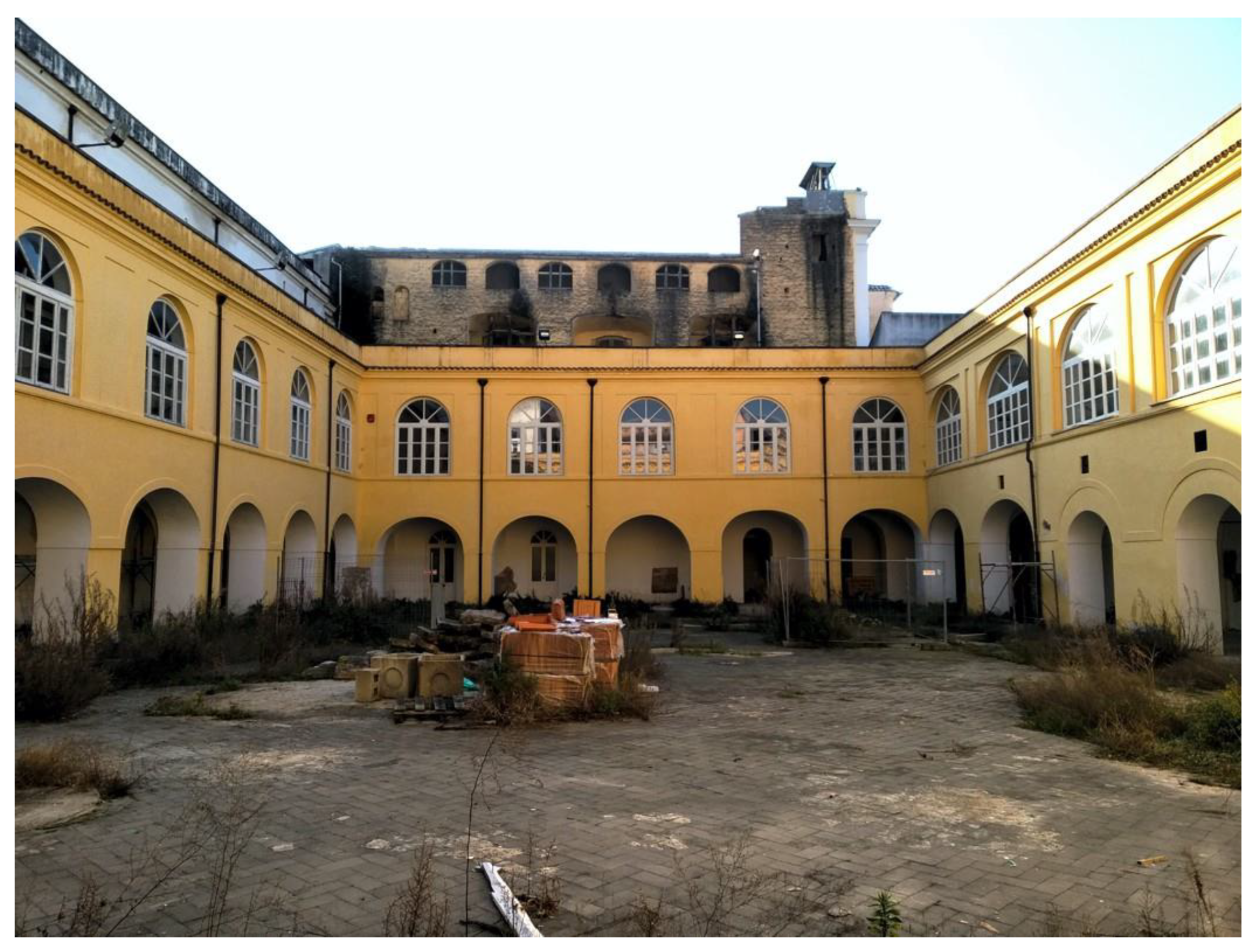
The Cloister of Sant’Agostino
3. Methods
3.1. Geological and Geotechnical Characterization
3.2. Electrical Resistivity Tomography
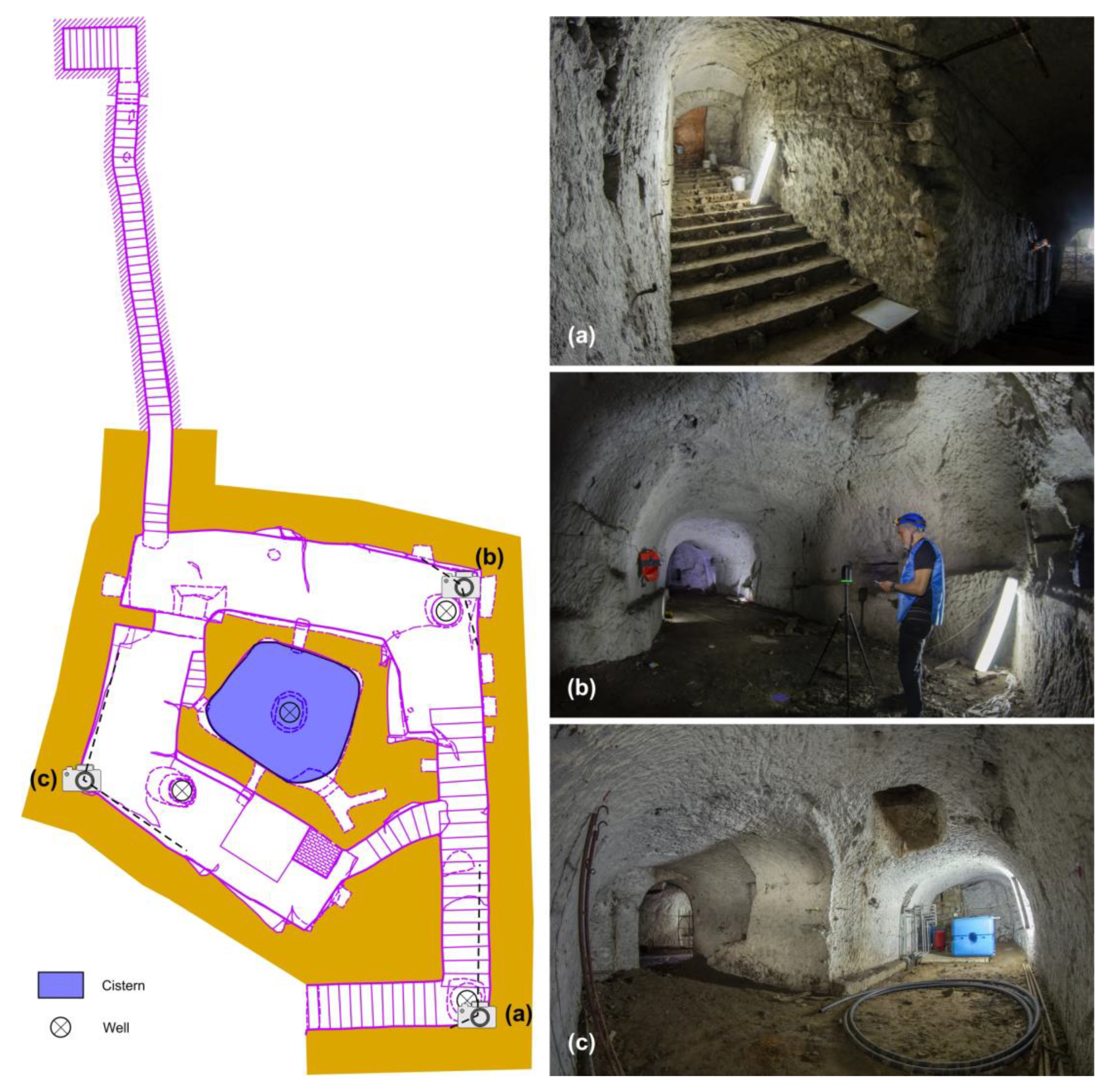
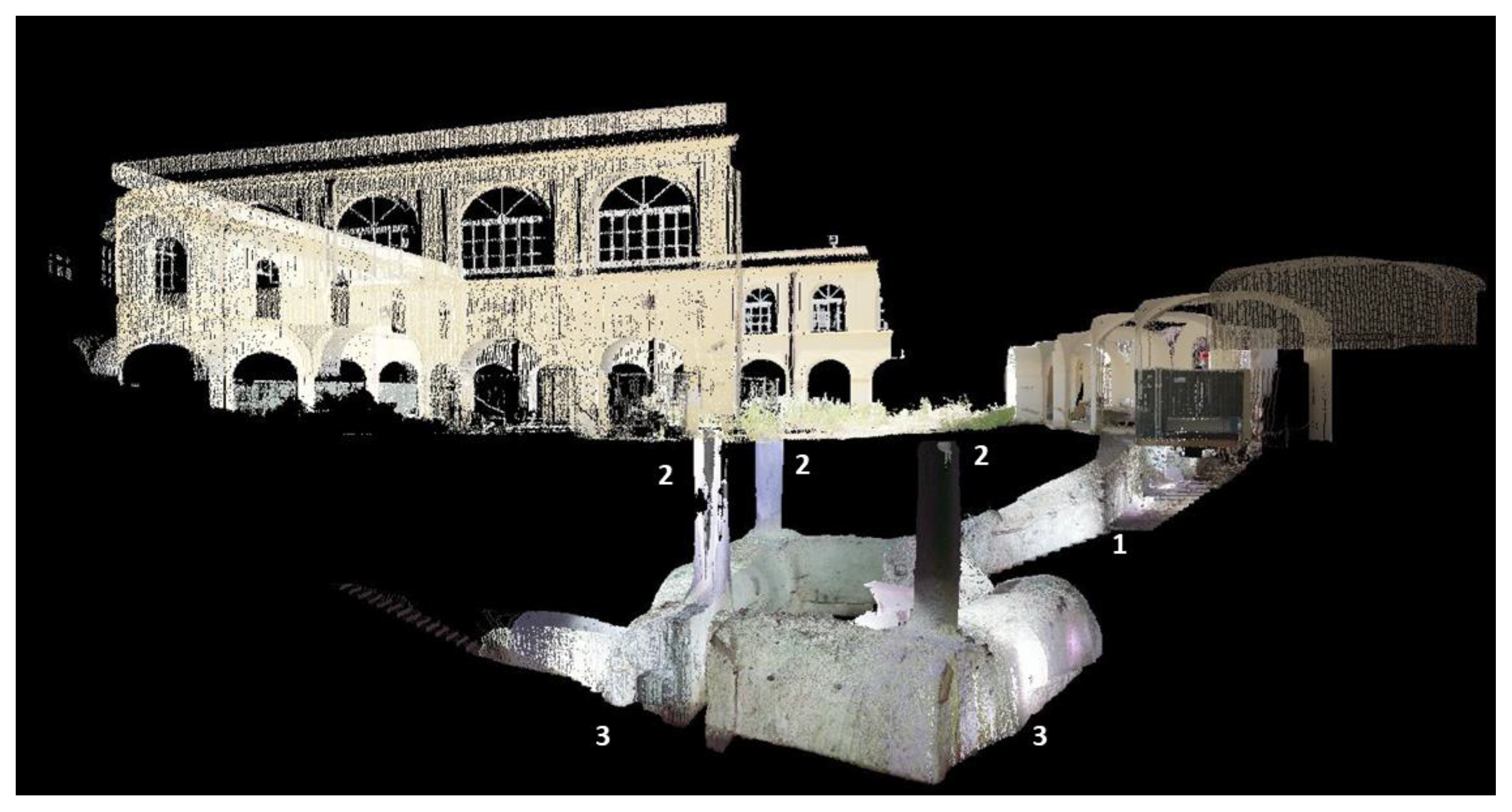
3.3. Laser Scanner
4. Results and Discussion
4.1. The Cloister of Sant’Agostino Architecture
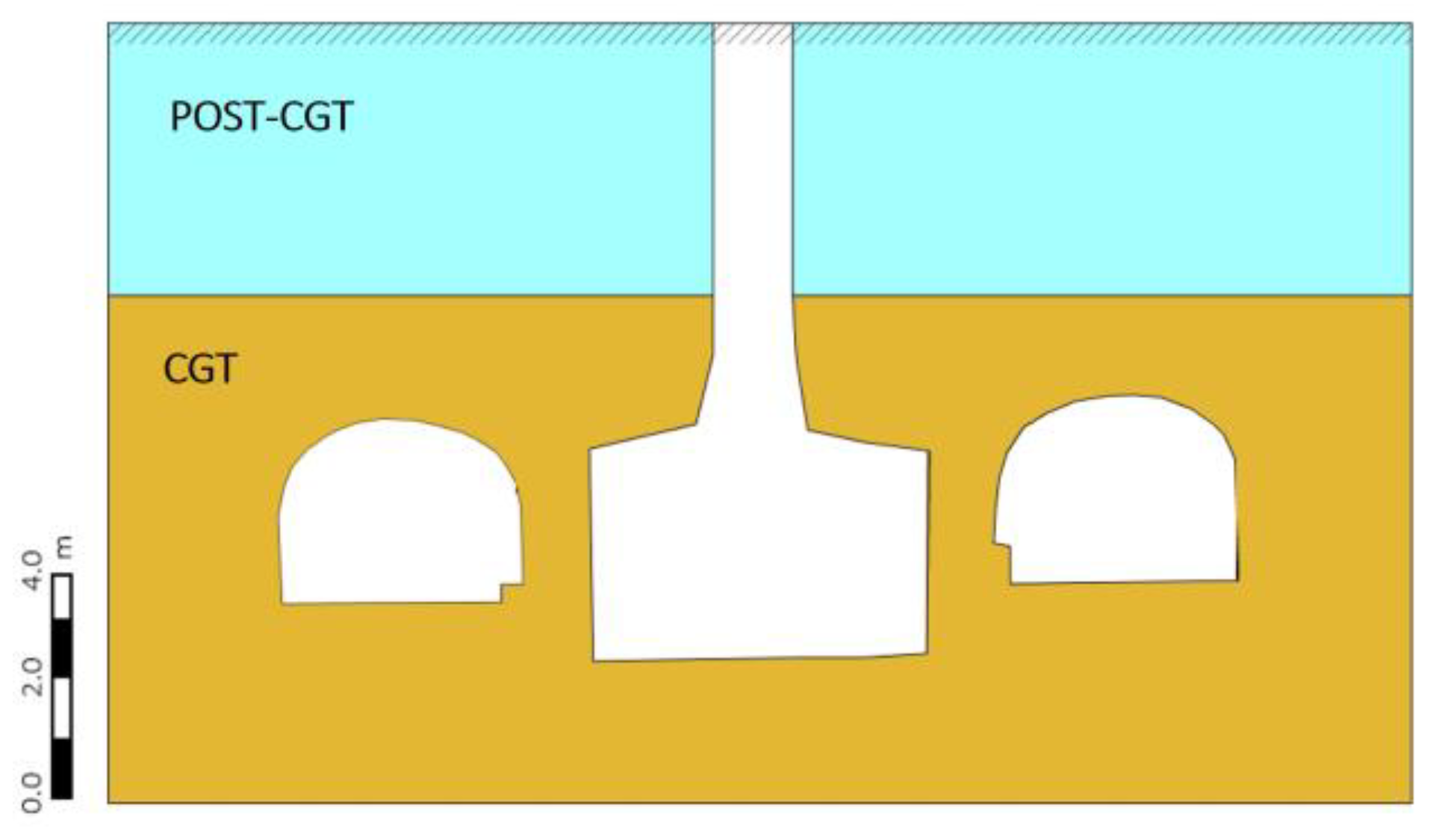
4.2. Geological and Geotechnical Characterization
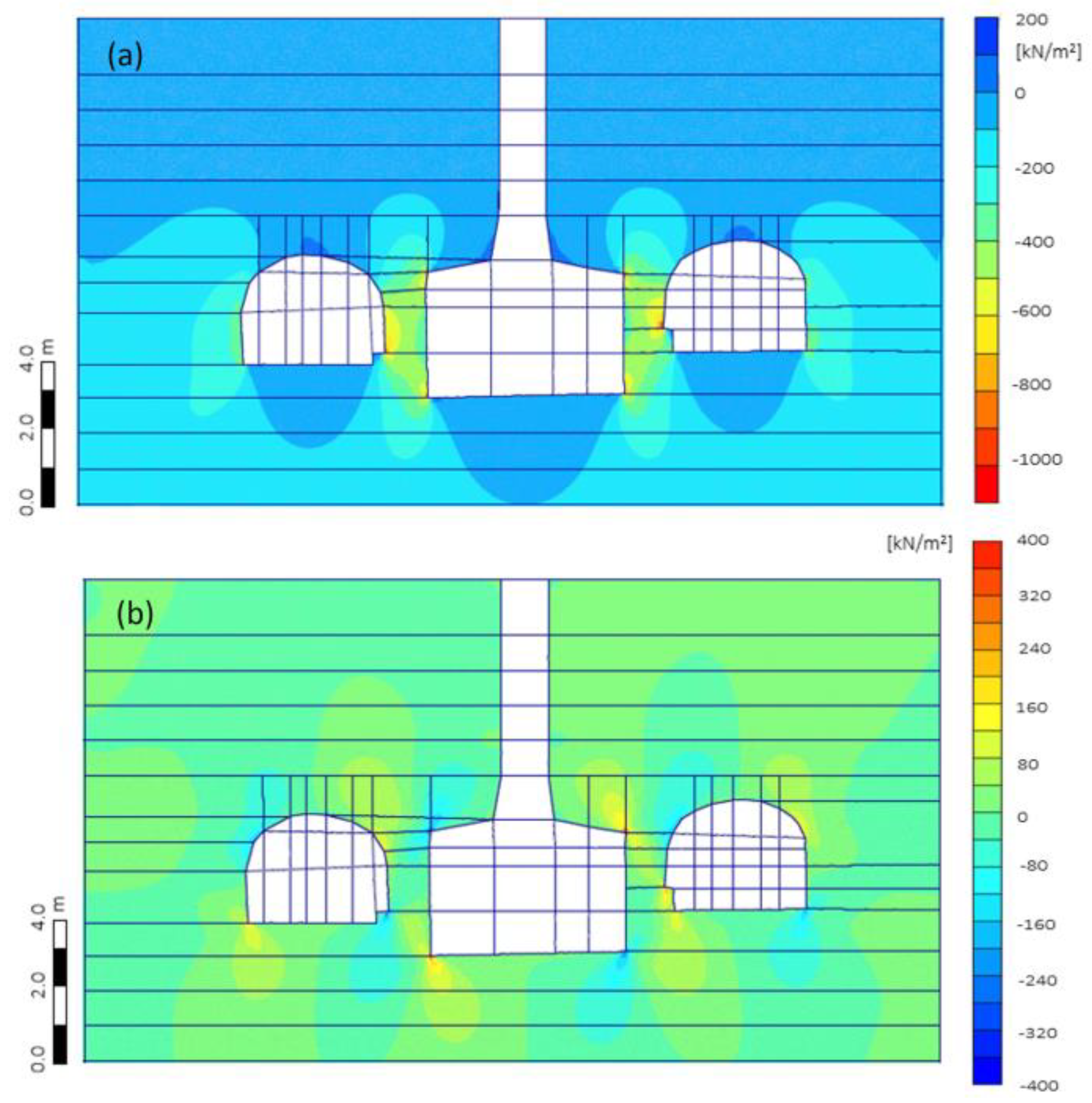
4.3. Stability
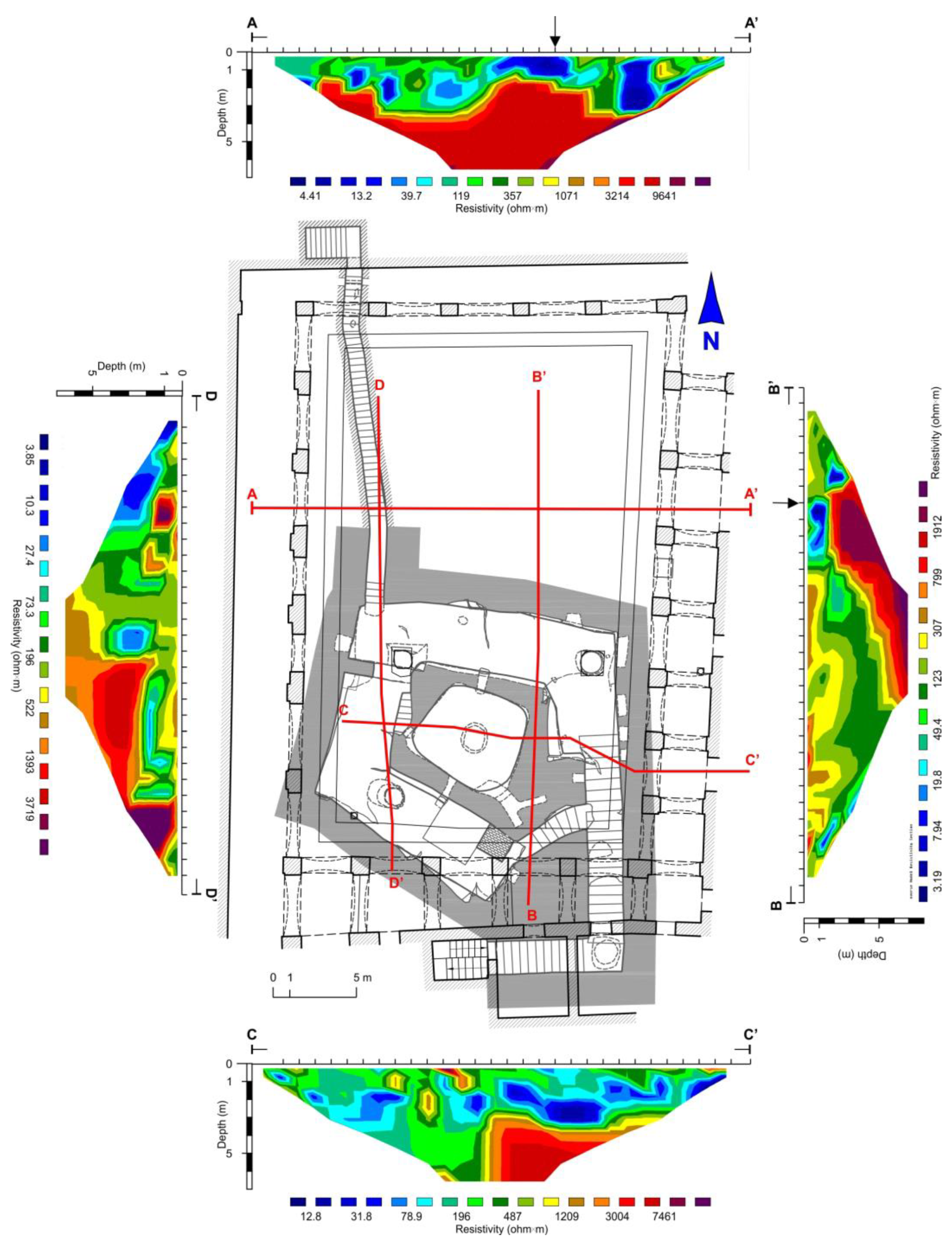
4.4. ERT
- Blue electrical resistivity between 3.19 and 7.94 ohm.m, associated with the presence of infiltration water;
- Light blue electrical resistivity between 7.94 and 19.8 ohm.m, associated with humidified pyroclastics, often humified (pedogenized), with slightly compacted silty grain size distribution;
- Electrical resistivity between 19.8 and 123 ohm.m of light green and dark green colors, associated with medium compacted reworked sandy pyroclastics;
- Electrical resistivity between 123 and 766 ohm.m of yellow, ocher-yellow, orange, red and dark red color, associated with dense sandy pyroclastics; they correspond to reworked materials in the more superficial layers;
- Bordeaux red electrical resistivities higher than 766 ohm.m could be associated with very compact gray tuff or voids due to cavities.
4.5. Discussion
5. Conclusions
Author Contributions
Funding
Data Availability Statement
Acknowledgments
Conflicts of Interest
References
- Brockx, M.; Semeniuk, V. Geoheritage and geoconservation—History, definition, scope and scale. J. R. Soc. West. Aust. 2007, 90, 53–87. [Google Scholar]
- Pijet-Migon, E.; Migon, P. Geoheritage and Cultural Heritage—A Review of Recurrent and Interlinked Themes. Geosciences 2022, 12, 98. [Google Scholar] [CrossRef]
- Reynard, E.; Giusti, C. The landscape and the cultural value of geoheritage. In Geoheritage. Assessment, Protection, and Management; Reynard, E., Brilha, J., Eds.; Elsevier: Amsterdam, The Netherlands, 2018; pp. 147–166. [Google Scholar]
- De Wever, P.; Baudin, F.; Pereira, D.; Cornée, A.; Egoroff, G.; Page, K. The importance of geosites and heritage stones in cities—A review. Geoheritage 2017, 9, 561–575. [Google Scholar] [CrossRef]
- Del Lama, E.A. Potential for urban geotourism: Churches and cemeteries. Geoheritage 2019, 11, 717–728. [Google Scholar] [CrossRef]
- Pereira, L.S.; do Nascimento, M.A.L.; Mantesso-Neto, V. Geotouristic trail in the Senhor da Boa Sentença Cemetery, João Pessoa, State of Paraíba (PB), Northeastern Brazil. Geoheritage 2019, 11, 1133–1149. [Google Scholar] [CrossRef]
- Galeazzi, C. The Typological Tree of Artificial Cavities: A Contribution by the Commission of the Italian Speleological Society. Opera Ipogea-J. Speleol. Artif. Cavities 2013, 1, 9–18. [Google Scholar]
- Parise, M.; Galeazzi, C.; Bixio, R.; Dixon, M. Classification of Artificial Cavities: A First Contribution by the UIS Commission. In Proceedings of the 16th International Congress of Speleology, Brno, Czech Republic, 21–28 July 2013; Filippi, M., Lollino, P., Eds.; pp. 230–235. [Google Scholar]
- Varriale, R. Underground Built Heritage: A Theoretical Approach for the Definition of an International Class. Heritage 2021, 4, 1092–1118. [Google Scholar] [CrossRef]
- Ebanista, C. L’utilizzo Cultuale Delle Grotte Campane nel Medioevo, in Campania Speleologica; I Convegno Regionale di Speleologia: Oliveto Citra, Italy, 2007. [Google Scholar]
- Ebanista, C. Abitati e luoghi di culto rupestri in Campania e Molise. In Le Aree Rupestri Dell’italia Centro·Meridionale, Nell’ambito Delle Civiltà italiche: Conoscenza, Salvaguardia, Tutela. IV Convegno Internazionale Sulla Civiltà Rupestre, Savelletri di Fasano, Italy, 17 November 2011; Menesto, E., Ed.; Cisam: Spoleto, Italy, 2011. [Google Scholar]
- Palmer, A. Cave Geology; Cave Books: Dayton, OH, USA, 2007; pp. 1–456. [Google Scholar]
- Parise, M. Il Progetto “La Carta degli Antichi Acquedotti Italiani”. Opera Ipogea 2007, 1, 3–16. [Google Scholar]
- Parise, M. Distribution and characteristics of ancient underground aqueducts in Italy. In Proceedings of the IWA Specialty Conference, 2nd International Symposium “Water and Wastewater Technologies in Ancient Civilizations”, Bari, Italy, 28 May 2009. [Google Scholar]
- Parise, M. Lo sviluppo degli insediamenti rupestri in funzione delle caratteristiche fisiografiche del territorio. In Proceedings of the Seminario Internazionale CRHIMA “Rupestrian Settlements in the Mediterranean Region”, Massafra, Italy, 28 April 2011. [Google Scholar]
- Varriale, R.; Parise, M.; Genovese, L.; Leo, M.; Valese, S. Underground Built Heritage in Naples: From Knowledge to Monitoring and Enhancement. In Handbook of Cultural Heritage Analysis; D’Amico, S., Venuti, V., Eds.; Springer: Cham, The Netherland, 2022. [Google Scholar] [CrossRef]
- Del Prete, S.; Parise, M. An overview of the geological and morphological constraints in the excavation of artificial cavities. In Proceedings of the 16th International Congress of Speleology, Brno, Czech Republic, 21–28 July 2013. [Google Scholar]
- Prosser, C.D. Geoconservation, quarrying and mining: Opportunities and challenges illustrated through working in partnership with the mineral extraction industry in England. Geoheritage 2018, 10, 259–270. [Google Scholar] [CrossRef]
- Scotto di Santolo, A.; de Silva, F.; Calcaterra, D.; Silvestri, F. Site effects due to the presence of cavity near the cliffs. In Proceedings of the 6th International Conference on Earthquake Geotechnical Engineering, Christchurch, New Zealand, 1–4 November 2015. [Google Scholar]
- Del Prete, S.; Galeazzi, C.; Germani, C.; Martimucci, V.; Parise, M. Geohydrological Problems Related to Underground Artificial Cavities. In Proceedings of the Convegni Lincei “Frane e Dissesto Idrogeologico: Consuntivo”; Accademia dei Lincei: Rome, Italy, 2010. [Google Scholar]
- Parise, M.; Lollino, P. A Preliminary Analysis of Failure Mechanisms in Karst and Man-Made Underground Caves in Southern Italy. Geomorphology 2011, 134, 132–143. [Google Scholar] [CrossRef]
- Parise, M. A present risk from past activities: Sinkhole occurrence above underground quarries. Carbonates Evaporites 2012, 27, 109–118. [Google Scholar] [CrossRef]
- Parise, M. Engineering-geological studies in artificial cavities, aimed at evaluating the possibility of failures in underground settings. In Proceedings of the Congress in Artificial Cavities “Hypogea 2017”, Cappadocia, Turkey, 6 March 2017. [Google Scholar]
- Vennari, C.; Parise, M. A Chronological Database about Natural and Anthropogenic Sinkholes in Italy. Geosciences 2022, 12, 200. [Google Scholar] [CrossRef]
- Dobereiner, L.; De Freitas, M.H. Geotechnical properties of weak sandstones. Géotechnique 1986, 36, 79–94. [Google Scholar] [CrossRef]
- Castellanza, R.; Lollino, P.; Ciantia, M. A methodological approach to assess the hazard of underground cavities subjected to environmental weathering. Tunn. Undergr. Space Technol. 2018, 82, 278–292. [Google Scholar] [CrossRef]
- Parise, M. Sinkholes, Subsidence and Related Mass Movements. In Treatise on Geomorphology; Shroder, J.J.F., Ed.; Elsevier Academic Press: Cambridge, MA, USA, 2022; Volume 5, pp. 200–220. ISBN 9780128182345. [Google Scholar]
- Ippolito, F.; Ortolani, F.; Russo, M. Struttura marginale tirrenica dell’Appennino campano: Reinterpretazioni di dati di antiche ricerche di idrocarburi. Mem. Soc. Geol. Ital. 1973, 12, 227–250. [Google Scholar]
- Cinque, A.; Alinaghi, H.H.; Laureti, L.; Russo, F. Osservazioni preliminari sull’evoluzione geomorfologica della Piana del Sarno (Campania, Appennino meridionale). Geogr. Fis. Dinam. Quat. 1987, 10, 161–174. [Google Scholar]
- Cinque, A.; Ascione, A.; Caiazzo, C. Distribuzione spaziotemporale e caratterizzazione della fagliazione quaternaria in Appennino meridionale. In Le ricerche del GNDT nel Campo Della Pericolosità Sismica (1996–1999); Galadini, F., Meletti, C., Melez, A., Eds.; CNR-GNDT Special Publication: Roma, Italy, 2000; pp. 203–218. [Google Scholar]
- Milia, A.; Torrente, M.M.; Russo, M.; Zuppetta, A. Tectonics and Crustal Structure of the Campania Continental Margin: Relationships with Volcanism. Mineral. Petrol. 2003, 79, 33–47. [Google Scholar] [CrossRef]
- Ruberti, D.; Sacchi, M.; Pepe, F.; Vigliotti, M. LGM Incised Valley in a volcanic setting. The Northern Campania Plain (Southern Italy). Alp. Mediterr. Quat. 2018, 31, 35–38. [Google Scholar]
- Vitale, S.; Ciarcia, S. Tectono-stratigraphic setting of the Campania region (southern Italy). J. Maps. 2018, 14, 9–21. [Google Scholar] [CrossRef]
- Buffardi, C.; Barbato, R.; Vigliotti, M.; Mandolini, A.; Ruberti, D. The Holocene Evolution of the Volturno Coastal Plain (Northern Campania, Southern Italy): Implications for the Understanding of Subsidence Patterns. Water 2021, 13, 2692. [Google Scholar] [CrossRef]
- De Vivo, B.; Rolandi, G.; Gans, P.B.; Calvert, A.; Bohrson, W.A.; Spera, F.J.; Belkin, H.E. New constraints on the pyroclastic eruptive history of the Campanian volcanic Plain (Italy). Mineral. Petrol. 2001, 73, 47–65. [Google Scholar] [CrossRef]
- Deino, A.L.; Orsi, G.; de Vita, S.; Piochi, M. The age of the Neapolitan Yellow Tuff caldera-forming eruption (Campi Flegrei caldera-Italy) assessed by 40Ar/39Ar dating method. J. Volcanol. Geotherm. Res. 2004, 133, 157–170. [Google Scholar] [CrossRef]
- Ruberti, D.; Vigliotti, M.; Rolandi, R.; Di Lascio, M. Effect of paleomorphology on facies distribution of the campania ignimbrite in the northern campania plain, southern Italy. In Vesuvius, Campi Flegrei, and Campanian Volcanism; De Vivo, B., Belkin, H.E., Rolandi, G., Eds.; Elsevier: Amsterdam, The Netherlands, 2020; pp. 207–229. [Google Scholar] [CrossRef]
- Di Girolamo, P. Petrografia Dei Tufi Campani: Il Processo Dipipernizzazione (Tufo → Tufo Pipernoide → Piperno). Rend. Ac-cad. Sci. Fis. Mat. 1968, 35, 329–394. [Google Scholar]
- Cappelletti, P.; Cerri, G.; Colella, A.; De Gennaro, M.; Langella, A.; Perrotta, A.; Scarpati, C. Post-Eruptive Processes in the Campanian Ignimbrite. Mineral. Petrol. 2003, 79, 79–97. [Google Scholar] [CrossRef]
- Morra, V.; Calcaterra, D.; Cappelletti, P.; Colella, A.; Fedele, L.; de Gennaro, R.; Langella, A.; Mercurio, M.; de Gennaro, M. Urban Geology: Relationships between Geological Setting and Architectural Heritage of the Neapolitan Area. J. Virtual Explor. 2010, 36, 27. [Google Scholar] [CrossRef]
- Ruberti, D.; Vigliotti, M.; Marzaioli, R.; Pacifico, A.; Ermice, A. Stratigraphic Architecture and Anthropic Impacts on Subsoil to Assess the Intrinsic Potential Vulnerability of Groundwater: The Northeastern Campania Plain Case Study, Southern Italy. Environ. Earth Sci. 2014, 71, 319–339. [Google Scholar] [CrossRef]
- Vigliotti, M.; Fabozzi, M.A.; Buffardi, C.; Ruberti, D. Artificial Cavities in the Northern Campania Plain: Architectural Variability and Cataloging Challenge. Heritage 2023, 6, 5500–5515. [Google Scholar] [CrossRef]
- Skempton, A.W. Standard Penetration Tests Procedures & the Effects in Sands of Overburden Pressure, Relative Density, Particle Size, Ageing and Overconsolidation. Géotechnique 1986, 36, 425–447. [Google Scholar]
- Hatanaka, M.; Uchida, A. Empirical Correlation Between Penetration Resistance and Internal Friction Angle of Sandy Soils. Soils Found. 1996, 36, 1–9. [Google Scholar] [CrossRef]
- Picarelli, L.; Evangelista, A.; Rolandi, G.; Paone, A.; Nicotera, N.V.; Livares, O.; di Santolo, A.S.; Lampitiello, S.; Rolandi, M. Mechanical properties of pyroclastic soils in Campania Region. In Proceedings of the 2nd International Workshop on Characterization and Engineering Properties of Natural Soils, Singapore, 5–7 December 2006; Volume 4, pp. 2331–2384. [Google Scholar]
- Olivares, L.; Damiano, E.; Netti, N.; de Cristofaro, M. Geotechnical Properties of Two Pyroclastic Deposits Involved in Catastrophic Flowslides for Implementation in Early Warning Systems. Geosciences 2019, 9, 24. [Google Scholar] [CrossRef]
- Damiano, E.; de Cristofaro, M.; Brunzo, A.; Carrieri, G.; Iavazzo, L.; Netti, N.; Olivares, L. The Mechanical Characterization of Pyroclastic Deposits for Landslide Early Warning Systems. Geosciences 2023, 13, 291. [Google Scholar] [CrossRef]
- Aversa, S.; Evangelista, A. Mechanical behaviour of a volcanic tuff: Yield, strength and “destructuration” effects. Rock Mech. Rock Eng. 1998, 31, 25–42. [Google Scholar] [CrossRef]
- Ceroni, F.; Pece, M.; Manfredi, G.; Marcari, G.; Voto, S. Analisi e caratterizzazione meccanica di murature di tufo. In Proceedings of the 15° Congresso C.T.E, Bari, Italy, 4 November 2004. [Google Scholar]
- Langella, A.; Bish, D.L.; Calcaterra, D.; Cappelletti, P.; Cerri, G.; Colella, A.; Graziano, S.F.; Papa, L.; Perrotta, A.; Scarpati, C.; et al. L’Ignimbrite Campana (IC). In Le Pietre Storiche della Campania Dall’oblio Alla Riscoperta; M. De Gennaro, D. Calcaterra, A. Langella Eds., 2013, 155–178; ISBN 9788860261823.
- de Silva, F.; Ramondini, M.; Flora, A. Reliability-based evaluation of the stability of underground cavities in Naples. In Geotechnical Engineering in the Digital and Technological Innovation Era; CNRIGFerrari, A., Rosone, M., Ziccarelli, M., Gottardi, G., Eds.; Springer: Cham, The Nertherland, 2023. [Google Scholar] [CrossRef]
- Carrara, E.; Rapolla, A.; Roberti, N. Le indagini Geofisiche per lo Studio del Sottosuolo: Metodi Geoelettrici e Sismici; Liguori: Napoli, Italy, 1992; ISBN 8820720868. [Google Scholar]
- Evangelista, L.; de Silva, F.; d’Onofrio, A.; Di Fiore, V.; Silvestri, F.; Scotto di Santolo, A.; Cavuoto, G.; Punzo, M.; Tarallo, D. Application of ERT and GPR geophysical testing to the subsoil characterization of cultural heritage sites in Napoli (Italy). Measurement 2017, 104, 326–335. [Google Scholar] [CrossRef]
- Singh, S.K.; Banerjee, B.P.; Raval, S. A review of laser scanning for geological and geotechnical applications in underground mining. Int. J. Min. Sci. Technol. 2023, 33, 133–154. [Google Scholar] [CrossRef]
- Dewez, T.J.B.; Yart, S.; Thuon, Y.; Pannet, P.; Plat, E. Towards cavity-collapse hazard maps with Zeb-Revo handheld laser scanner point clouds. Photogram Rec. 2017, 32, 354–376. [Google Scholar] [CrossRef]
- Cardarelli, E.; Di Filippo, G.; Tuccinardi, E. Electrical resistivity tomography to detect buried cavities in Rome: A case study. Near Surf. Geophys. 2006, 4, 387–392. [Google Scholar] [CrossRef]
- Ungureanu, C.; Priceputu, A.; Bugea, A.L.; Chirică, A. Use of electric resistivity tomography (ERT) for detecting underground voids on highly anthropized urban construction sites. Procedia Eng. 2017, 209, 202–209. [Google Scholar] [CrossRef]
- COST. CA18110—Underground Built Heritage as Catalyser for Community Valorisation (Underground4value). Available online: https://www.cost.eu/ (accessed on 1 October 2023).
- Lollino, P.; Parise, M.; Vattano, M. Some Considerations on 3-D and 2-D Numerical Models for the Assessment of the Stability of Underground Caves. In Engineering Geology for Society and Territory; Volume 5—Urban Geology, Sustainable Planning and Landscape Exploitation; Lollino, G., Manconi, A., Guzzetti, F., Culshaw, M., Bobrowsky, P., Luino, F., Eds.; Springer: Heidelberg, Germany, 2014; pp. 585–588. [Google Scholar]
- Parise, M. A procedure for evaluating the susceptibility to natural and anthropogenic sinkholes. Georisk Assess. Manag. Risk Eng. Syst. Geohazards 2015, 9, 272–285. [Google Scholar] [CrossRef]
- Ducut, J.D.; Alipio, M.; Go, P.J.; Concepcion II, R.; Vicerra, R.R.; Bandala, A.; Dadios, E. A Review of Electrical Resistivity Tomography Applications in Underground Imaging and Object Detection. Displays 2022, 73, 102208. [Google Scholar] [CrossRef]


| Depth (m) | Soil | γ (kN/m3) | ν | c’ (kPa) | φ’ (°) | σc (MPa) | E (MPa) |
|---|---|---|---|---|---|---|---|
| 0–4.50 | Post-CGT | 15 | 0.30 | 15 | 35° | - | 170 |
| >4.50 | CGT | 14 | 0.30 | 270 | 35° | 1.07 | 620 |
Disclaimer/Publisher’s Note: The statements, opinions and data contained in all publications are solely those of the individual author(s) and contributor(s) and not of MDPI and/or the editor(s). MDPI and/or the editor(s) disclaim responsibility for any injury to people or property resulting from any ideas, methods, instructions or products referred to in the content. |
© 2024 by the authors. Licensee MDPI, Basel, Switzerland. This article is an open access article distributed under the terms and conditions of the Creative Commons Attribution (CC BY) license (https://creativecommons.org/licenses/by/4.0/).
Share and Cite
Damiano, E.; Fabozzi, M.A.; Guarino, P.M.; Molitierno, E.; Olivares, L.; Pratelli, R.; Vigliotti, M.; Ruberti, D. A Multidisciplinary Approach for the Characterization of Artificial Cavities of Historical and Cultural Interest: The Case Study of the Cloister of Sant’Agostino—Caserta, Italy. Geosciences 2024, 14, 42. https://doi.org/10.3390/geosciences14020042
Damiano E, Fabozzi MA, Guarino PM, Molitierno E, Olivares L, Pratelli R, Vigliotti M, Ruberti D. A Multidisciplinary Approach for the Characterization of Artificial Cavities of Historical and Cultural Interest: The Case Study of the Cloister of Sant’Agostino—Caserta, Italy. Geosciences. 2024; 14(2):42. https://doi.org/10.3390/geosciences14020042
Chicago/Turabian StyleDamiano, Emilia, Maria Assunta Fabozzi, Paolo Maria Guarino, Erika Molitierno, Lucio Olivares, Roberto Pratelli, Marco Vigliotti, and Daniela Ruberti. 2024. "A Multidisciplinary Approach for the Characterization of Artificial Cavities of Historical and Cultural Interest: The Case Study of the Cloister of Sant’Agostino—Caserta, Italy" Geosciences 14, no. 2: 42. https://doi.org/10.3390/geosciences14020042
APA StyleDamiano, E., Fabozzi, M. A., Guarino, P. M., Molitierno, E., Olivares, L., Pratelli, R., Vigliotti, M., & Ruberti, D. (2024). A Multidisciplinary Approach for the Characterization of Artificial Cavities of Historical and Cultural Interest: The Case Study of the Cloister of Sant’Agostino—Caserta, Italy. Geosciences, 14(2), 42. https://doi.org/10.3390/geosciences14020042