


Subduction of Submarine Arc Volcanoes Beneath the Solomon Islands Arc

Abstract
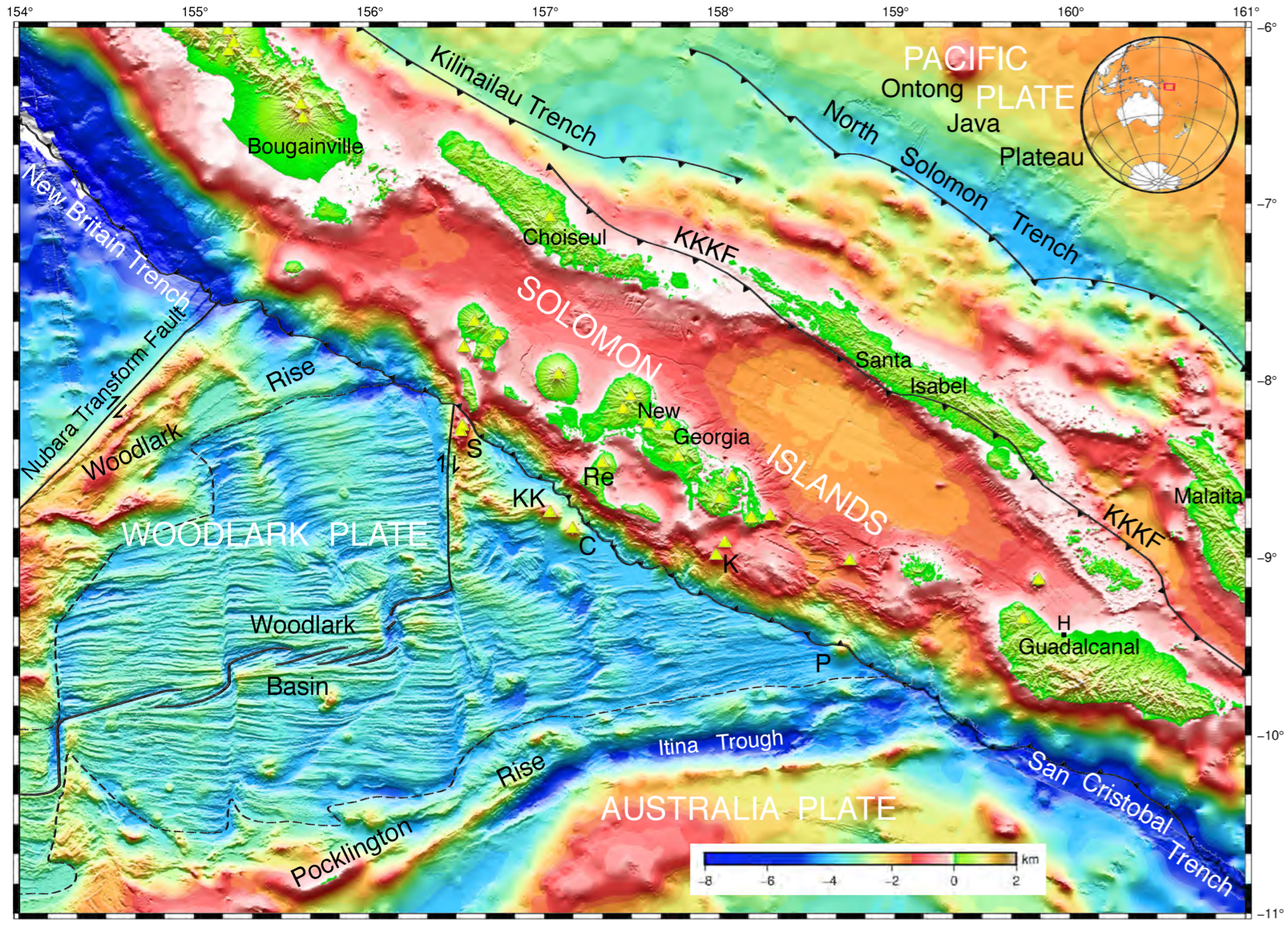
1. Introduction

2. Methods
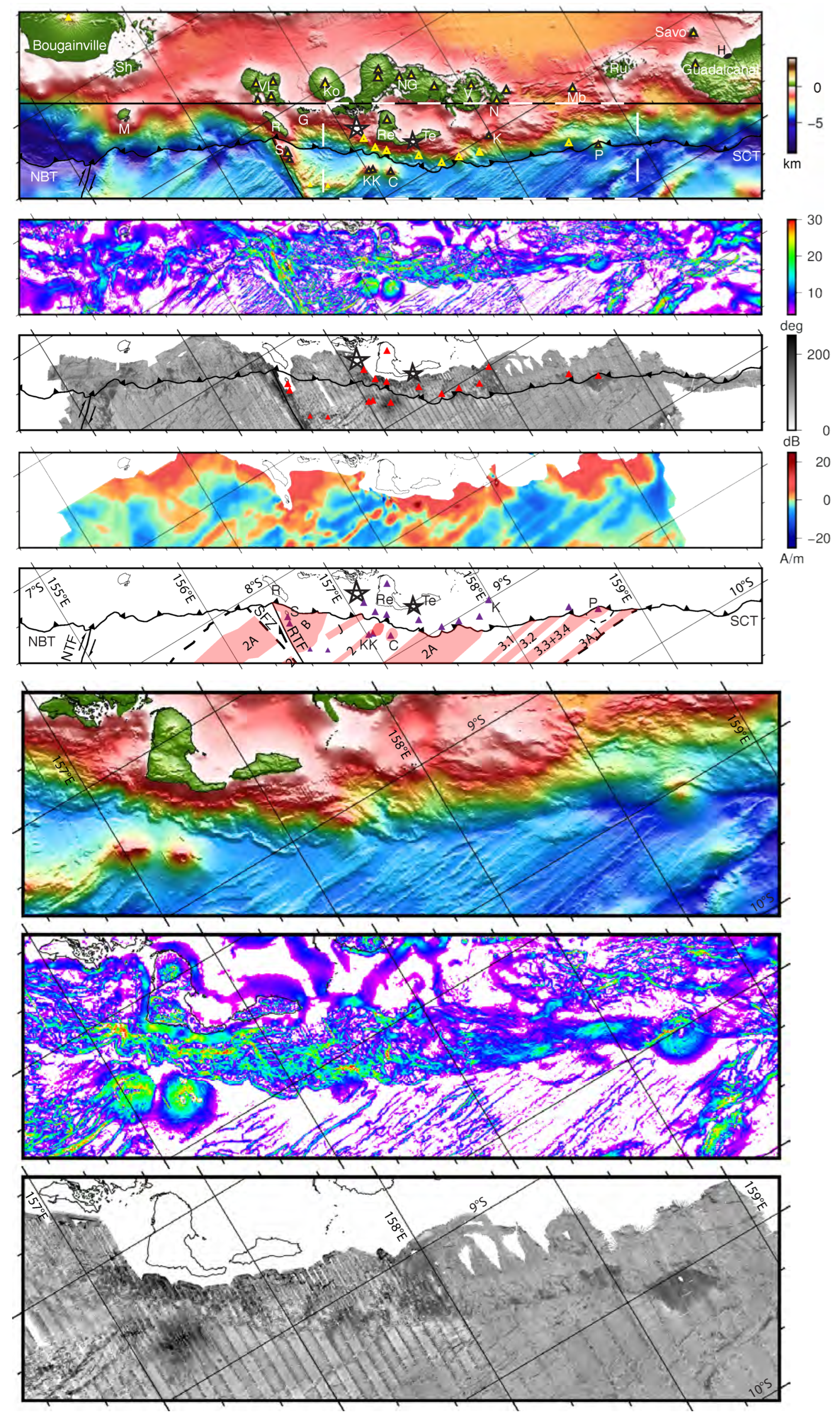
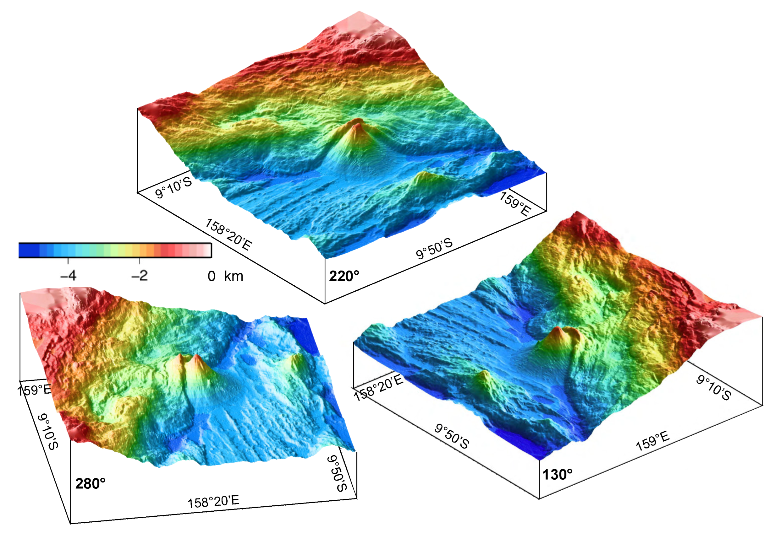
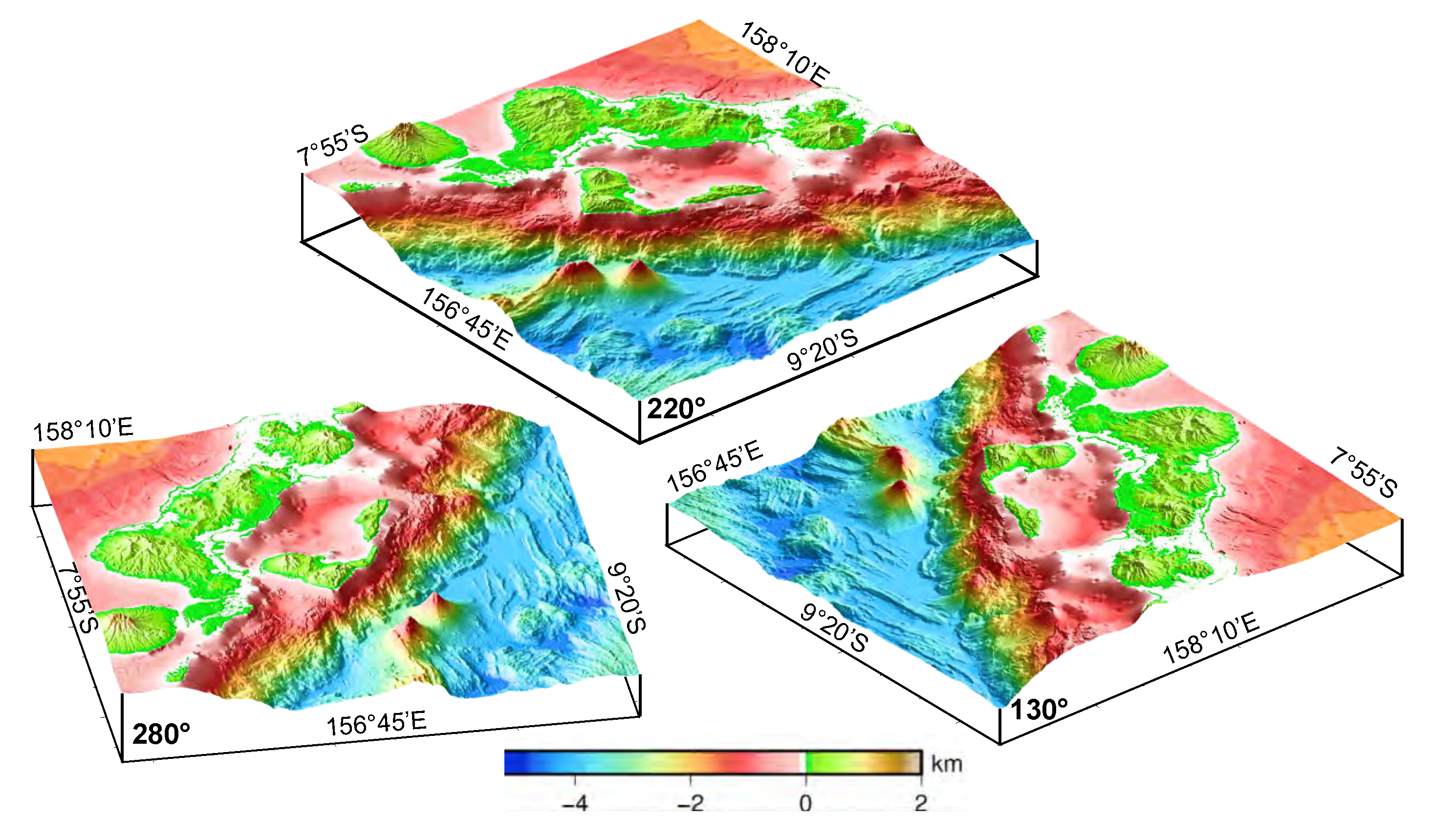
3. Results
4. Discussion
5. Conclusions
Author Contributions
Funding
Data Availability Statement
Acknowledgments
Conflicts of Interest
References
- Gill, J.B. Orogenic Andesites and Plate Tectonics; Springer: Berlin/Heidelberg, Germany, 1981; 390p. [Google Scholar]
- Weissel, J.K.; Taylor, B.; Karner, G.D. The opening of the Woodlark Basin, subduction of the Woodlark spreading system, and the evolution of northern Melanesia since mid-Pliocene time. Tectonophysics 1982, 87, 253–277. [Google Scholar] [CrossRef]
- Cooper, P.; Taylor, B. Polarity reversal in the Solomon Islands arc. Nature 1985, 314, 428–430. [Google Scholar] [CrossRef]
- Taylor, B.; Exon, N.F. An investigation of ridge subduction in the Woodlark-Solomons region: Introduction and overview. In Marine Geology, Geophysics, and Geochemistry of the Woodlark Basin—Solomon Islands; Taylor, B., Exon, N.F., Eds.; Earth Science Series; Circum-Pacific Council for Energy and Mineral Resources: Houston, TX, USA, 1987; Volume 7, pp. 1–24. [Google Scholar]
- Mann, P.; Taira, A. Global tectonic significance of the Solomon Islands and Ontong Java Plateau convergent zone. Tectonophysics 2004, 389, 137–190. [Google Scholar] [CrossRef]
- Martinez, F.; Taylor, B.; Goodliffe, A. Contrasting styles of seafloor spreading in the Woodlark Basin: Indications of rift-induced secondary mantle convection. J. Geophys. Res. 1999, 104, 12909–12926. [Google Scholar] [CrossRef]
- Cooper, P.; Taylor, B. The spatial distribution of earthquakes, focal mechanisms and subducted lithosphere in the Solomon Islands. In Marine Geology, Geophysics, and Geochemistry of the Woodlark Basin—Solomon Islands; Taylor, B., Exon, N.F., Eds.; Earth Science Series; Circum-Pacific Council for Energy and Mineral Resources: Houston, TX, USA, 1987; Volume 7, pp. 67–88. [Google Scholar]
- Taylor, B.; Benyshek, E.K. Oceanic plateau and spreading ridge subduction accompanying arc reversal in the Solomon Islands. J. Geophys. Res. 2023. in review. [Google Scholar]
- Johnson, R.W.; Langmuir, C.H.; Perfit, M.R.; Staudigel, H.; Dunkley, P.N.; Chappell, B.W.; Taylor, S.R.; Baekisapa, M. Ridge subduction and forearc volcanism: Petrology and geochemistry of rocks dredged from the western Solomon Arc and Woodlark Basin. In Marine Geology, Geophysics, and Geochemistry of the Woodlark Basin—Solomon Islands; Taylor, B., Exon, N.F., Eds.; Earth Science Series; Circum-Pacific Council for Energy and Mineral Resources: Houston, TX, USA, 1987; Volume 7, pp. 155–226. [Google Scholar]
- Perfit, M.R.; Langmuir, C.H.; Backisapa, M.; Chappell, B.; Johnson, R.W.; Staudigel, H.; Taylor, S.R. Geochemistry and petrology of volcanic rocks from the Woodlark Basin: Addressing questions of ridge subduction. In Marine Geology, Geophysics and Geochemistry of the Woodlark Basin–Solomon Islands; Taylor, B., Exon, N., Eds.; Earth Science Series; Circum-Pacific Council for Energy and Mineral Resources: Houston, TX, USA, 1987; Volume 7, pp. 113–154. [Google Scholar]
- König, S.; Schuth, S.; Münker, C.; Qopoto, C. The role of slab melting in the petrogenesis of high-Mg andesites: Evidence from Simbo Volcano, Solomon Islands. Contrib. Mineral. Petrol. 2007, 153, 85–103. [Google Scholar] [CrossRef]
- Chadwick, J.; Perfit, M.; McInnes, B.; Kamenov, G.; Plank, T.; Jonasson, I.; Chadwick, C. Arc lavas on both sides of a trench: Slab window effects at the Solomon Islands triple junction, SW Pacific. Earth Planet. Sci. Lett. 2009, 279, 293–302. [Google Scholar] [CrossRef]
- Schuth, S.; Münker, C.; König, S.; Qopoto, C.; Basi, S.; Grabe-Schönberg, D.; Ballhaus, C. Petrogenesis of lavas along the Solomon Island Arc, SW Pacific: Coupling of compositional variations and subduction zone geometry. J. Petrol. 2009, 50, 781–811. [Google Scholar] [CrossRef]
- Schuth, S.; König, S.; Münker, C. Subduction zone dynamics in SW Pacific plate boundary region constrained from high-precision Pb isotope data. Earth Planet. Sci. Lett. 2011, 311, 328–338. [Google Scholar] [CrossRef]
- Global Volcanism Program; Venzke, E. Volcanoes of the World, v. 4.8.5; Smithsonian Institution: Washington, DC, USA, 2013. [Google Scholar]
- Crook, K.A.W.; Taylor, B. Structure and quaternary tectonic history of the Woodlark triple junction region, Solomon Islands. Mar. Geophys. Res. 1994, 16, 65–89. [Google Scholar] [CrossRef]
- Altamimi, Z.; Metivier, L.; Rebischung, P.; Rouby, H.; Collilieux, X. ITRF2014 plate motion model. Geophys. J. Int. 2017, 209, 1906–1912. [Google Scholar] [CrossRef]
- Tregoning, P.; Tan, F.; Gilliland, J.; McQueen, H.; Lambeck, K. Present-day crustal motion in the Solomon Islands from GPS observations. Geophys. Res. Lett. 1998, 25, 3627–3630. [Google Scholar] [CrossRef]
- Philipps, D.A. Crustal Motion Studies in the Southwest Pacific: Geodetic Measurements of Plate Convergence in Tonga, Vanuatu and the Solomon Islands. Ph.D. Thesis, University of Hawaii, Honolulu, HI, USA, 2003; 135p. [Google Scholar]
- Bruns, T.R.; Vedder, J.G.; Culotta, R.C. Structure and tectonics along the Kilinailau Trench, Bougainville-Buka island region, Papua New Guinea. In Geology and Offshore Resources of Pacific Island Arcs—Solomon Islands and Bougainville, Papua New Guinea Regions; Vedder, J.G., Bruns, T.R., Eds.; Earth Science Series; Circum-Pacific Council for Energy and Mineral Resources: Houston, TX, USA, 1989; Volume 12, pp. 93–123. [Google Scholar]
- SONEL. Solomon Islands (Honiara) Continuous GPS. 2023. Available online: https://www.sonel.org/spip.php?page=gps&idStation=2054 (accessed on 1 April 2023).
- Taylor, B.; Goodliffe, A.M.; Martinez, F. How continents break up: Insights from Papua New Guinea. J. Geophys. Res. 1999, 104, 7497–7512. [Google Scholar] [CrossRef]
- Goodliffe, A.M.; Taylor, B.; Martinez, F.; Hey, R.; Maeda, K.; Ohno, K. Synchronous reorientation of the Woodlark Basin spreading center. Earth Planet. Sci. Lett. 1997, 146, 233–242. [Google Scholar] [CrossRef]
- Benyshek, E.K.; Taylor, B. Tectonics of the Papua-Woodlark Region. Geochem. Geophys. Geosyst. 2021, 22, e2020GC009209. [Google Scholar] [CrossRef]
- Taylor, B. Itina Trough and other SW Pacific examples of rifting across former subduction/collision zones. Geophys. Res. Lett. 2021, 48, e2020GL092286. [Google Scholar] [CrossRef]
- Taylor, B. A geophysical survey of the Woodlark-Solomons region. In Marine Geology Geophysics, and Geochemistry of the Woodlark Basin—Solomon Islands; Taylor, B., Exon, N.F., Eds.; Earth Science Series; Circum-Pacific Council for Energy and Mineral Resources: Houston, TX, USA, 1987; Volume 7, pp. 25–48. [Google Scholar]
- Mann, P.; Taylor, F.W.; Lagoe, M.B.; Quarles, A.; Burr, G. Accelerating late Quaternary uplift of the New Georgia Island Group (Solomon island arc) in response to subduction of the recently active Woodlark spreading center and Coleman seamount. Tectonophysics 1998, 295, 259–306. [Google Scholar] [CrossRef]
- Taylor, F.W.; Mann, P.; Bevis, M.G.; Edwards, R.L.; Cheng, H.; Cutler, K.B.; Gray, S.C.; Burr, G.S.; Beck, J.W.; Phillips, D.A.; et al. Rapid forearc uplift and subsidence caused by impinging bathymetric features: Examples from the New Hebrides and Solomon arcs. Tectonics 2005, 24, TC6005. [Google Scholar] [CrossRef]
- Taylor, F.; Briggs, R.W.; Frolich, C.; Brown, A.; Hornbach, M.; Papabatu, A.K.; Meltzner, A.J.; Billy, D. Rupture across arc segment and plate boundaries in the 1 April 2007 Solomons earthquake. Nat. Geosci. 2008, 1, 253–257. [Google Scholar] [CrossRef]
- Thirumalai, K.; Taylor, F.W.; Shen, C.-C.; Lavier, L.L.; Frohlich, C.; Wallace, L.M.; Wu, C.-C.; Sun, H.; Papabatu, A.K. Variable Holocene deformation above a shallow subduction zone extremely close to the trench. Nat. Commun. 2015, 6, 7607. [Google Scholar] [CrossRef]
- Fisher, M.A.; Geist, E.L.; Sliter, R.W.; Wong, F.L.; Reiss, C.; Mann, D. Preliminary analysis of the earthquake (Mw 8.1) and tsunami of 1 April 2007, in the Solomon Islands, southwestern Pacific Ocean. Sci. Tsunami Hazards 2007, 26, 3. [Google Scholar]
- Furlong, K.P.; Lay, T.; Ammon, C. A great earthquake across a rapidly evolving three-plate boundary. Science 2009, 324, 226–229. [Google Scholar] [CrossRef] [PubMed]
- Chen, T.; Newman, A.V.; Feng, L.; Fritz, H.M. Slip distribution from the 1 April 2007 Solomon Islands earthquake: A unique image of near-trench rupture. Geophys. Res. Lett. 2009, 36, 1–6. [Google Scholar] [CrossRef]
- Chen, M.-C.; Frohlich, C.; Taylor, F.W.; Burr, G.; van Ufford, A.Q. Arc segmentation and seismicity in the Solomon Islands arc, SW Pacific. Tectonophysics 2011, 507, 47–69. [Google Scholar] [CrossRef]
- Newman, A.V.; Feng, L.; Fritz, H.M.; Lifton, Z.M.; Kalligeris, N.; Wei, Y. The energetic 2010 Mw 7.1 Solomon Islands tsunami earthquake. Geophys. J. Int. 2011, 186, 775–781. [Google Scholar] [CrossRef]
- Parker, R.L.; Huestis, S.P. The inversion of magnetic anomalies in the presence of topography. J. Geophys. Res. 1974, 79, 1587–1593. [Google Scholar] [CrossRef]
- von Huene, R.; Ranero, C.R.; Weinrebe, W.; Hinz, K. Quaternary convergent margin tectonics of Costa Rica, segmentation of the Cocos Plate, and Central American volcanism. Tectonics 2000, 19, 314–334. [Google Scholar] [CrossRef]
- Dominguez, S.; Lallemand, S.E.; Malavieille, J.; von Huene, R. Upper plate deformation associated with seamount subduction. Tectonophysics 1998, 293, 207–224. [Google Scholar] [CrossRef]
- Dominguez, S.; Malavieille, J.; Lallemand, S.E. Deformation of accretionary wedges in response to seamount subduction: Insights from sandbox experiments. Tectonics 2000, 19, 182–196. [Google Scholar] [CrossRef]
- Ruh, J.B.; Sallarès, V.; Ranero, C.R.; Gerya, T. Crustal deformation dynamics and stress evolution during seamount subduction: High-resolution 3-D numerical modeling. J. Geophys. Res. 2016, 121, 6880–6902. [Google Scholar] [CrossRef]
- Oakley, A.J.; Taylor, B.; Moore, G.F. Pacific Plate subduction beneath the central Mariana and Izu-Bonin fore arcs: New insights from an old margin. Geochem. Geophys. Geosyst. 2008, 9, Q06003. [Google Scholar] [CrossRef]
- Watts, A.B.; Koppers, A.A.P.; Robinson, S.P. Seamount subduction and earthquakes. Oceanography 2010, 23, 166–173. [Google Scholar] [CrossRef]
- Wang, K.; Bilek, S.L. Do subducting seamounts generate or stop large earthquakes? Geology 2011, 39, 819–822. [Google Scholar] [CrossRef]
- Sun, T.; Saffer, D.; Ellis, S. Mechanical and hydrological effects of seamount subduction on megathrust stress and slip. Nat. Geosci. 2020, 13, 249–255. [Google Scholar] [CrossRef]
- Engdahl, E.R.; Di Giacomo, D.; Sakarya, B.; Gkarlaouni, C.G.; Harris, J.; Storchak, D.A. ISC-EHB 1964-2016, an improved data set for studies of Earth structure and global seismicity. Earth Space Sci. 2020, 7, e2019EA000897. [Google Scholar] [CrossRef]
- Wessel, P.; Luis, J.F.; Uieda, L.; Scharroo, R.; Wobbe, F.; Smith, W.H.F.; Tian, D. The Generic Mapping Tools version 6. Geochem. Geophys. Geosyst. 2019, 20, 5556–5564. [Google Scholar] [CrossRef]


Disclaimer/Publisher’s Note: The statements, opinions and data contained in all publications are solely those of the individual author(s) and contributor(s) and not of MDPI and/or the editor(s). MDPI and/or the editor(s) disclaim responsibility for any injury to people or property resulting from any ideas, methods, instructions or products referred to in the content. |
© 2023 by the authors. Licensee MDPI, Basel, Switzerland. This article is an open access article distributed under the terms and conditions of the Creative Commons Attribution (CC BY) license (https://creativecommons.org/licenses/by/4.0/).
Share and Cite
Taylor, B.; Benyshek, E.K.; Goodliffe, A.M. Subduction of Submarine Arc Volcanoes Beneath the Solomon Islands Arc. Geosciences 2023, 13, 236. https://doi.org/10.3390/geosciences13080236
Taylor B, Benyshek EK, Goodliffe AM. Subduction of Submarine Arc Volcanoes Beneath the Solomon Islands Arc. Geosciences. 2023; 13(8):236. https://doi.org/10.3390/geosciences13080236
Chicago/Turabian StyleTaylor, Brian, Elizabeth K. Benyshek, and Andrew M. Goodliffe. 2023. "Subduction of Submarine Arc Volcanoes Beneath the Solomon Islands Arc" Geosciences 13, no. 8: 236. https://doi.org/10.3390/geosciences13080236
APA StyleTaylor, B., Benyshek, E. K., & Goodliffe, A. M. (2023). Subduction of Submarine Arc Volcanoes Beneath the Solomon Islands Arc. Geosciences, 13(8), 236. https://doi.org/10.3390/geosciences13080236