Abstract
The Tuscan Archipelago lies between the Ligurian Sea to the north and the Tyrrhenian Sea to the south and between Corsica to the west and the Tuscan coast to the east. It is made up of seven major islands, Elba, Giglio, Capraia, Montecristo, Pianosa, Giannutri and Gorgona (in order of size), and several smaller ones. Geologically, these islands are very different from each other. Elba combines all the characteristics of the northern Apennines with a large granodioritic pluton and a sequence of tectonic units with sedimentary successions of the Ligurian and Tuscan type. Giglio is a granitic pluton with a small patch of sedimentary cover. Capraia is an entirely volcanic island. Montecristo is a granitic pluton. Pianosa consists exclusively of Mio-Pliocene carbonate rocks. Giannutri consists of Mesozoic Cavernous Limestone, and Gorgona consists of calcschists, serpentinites and metabasites. This article examines the mortars used in the historical architecture of Capraia, Gorgona and Giglio, islands where limestones are almost absent, trying to investigate the provenance of the carbonate stones used to produce the lime through mineralogy–petrographic analyses. Mineralogical and petrographic analyses proved useful in identifying the raw materials used for the production of lime, also contextualising them in the historical and administrative vicissitudes of the islands. In particular, a magnesian lime of Ligurian origin was used in Capraia during the period when the island was under the rule of the Republic of Genoa. On Gorgona in the Middle Ages, the few outcrops of carbonate rock on the island, consisting of saccaroid marble, were exploited for the local production of lime, while in later times lime was sourced from the mainland. In Giglio, the small outcrops of dolostone and marbles on the western side of the island were exploited. This work has broadened knowledge in the use of materials and highlighted man’s knowledge of the area and its resources to such an extent that even small outcrops suitable for lime production were exploited. Attention is also drawn to the fact that, although sophisticated techniques provide excellent information, in many cases only a careful petrographic investigation allows the most useful information to be obtained in a cheap and easy way.
1. Introduction
Lime is the basic material for making mortars and the raw material for its production are carbonate rocks. These rocks are not homogenously spread and in some territories are completely absent; however, in the historical architecture of some of these territories, mortars were equally used and the problem of the origin of the raw materials used arises. This topic in the Mediterranean area has rarely been investigated; one case we can take as an example is that of Pantelleria island [1]. The case is different on volcanic islands in tropical areas where the coral from the coral reefs is burnt to produce lime [2].
This research examines the mortars of historical constructions on some islands of the Tuscan Archipelago where carbonate rocks for lime production are completely absent or present in very small outcrops [3,4].
The Tuscan Archipelago lies between the Ligurian Sea to the north and the Tyrrhenian Sea to the south and between Corsica to the west and the Tuscan coast to the east. It is made up of seven major islands, Elba, Giglio, Capraia, Montecristo, Pianosa, Giannutri and Gorgona (in order of size), and several smaller ones (Figure 1).
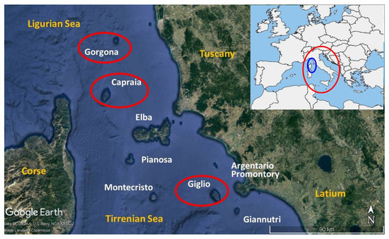
Figure 1.
The Tuscan Archipelago is made up of seven major islands, Elba, Giglio, Capraia, Montecristo, Pianosa, Giannutri and Gorgona. The red circle is the position of Italy in Europe and the blue circle is the position of the Tuscan Archipelago (from Google Earth (10 August 2019), 43°39′45″ N, 8°20′21″ E, Eye alt. 557 Km, Landsat, Copernicus, SIO, NOAA, U.S. Navy, NGA, GEBCO 2023, [5], modified).
All the islands are protected within one of the largest marine parks in the world, the Tuscan Archipelago National Park, established in 1980. Geologically, they are very different from each other as will be later explained.
Indeed, this article examines the lime used in the historical architecture of the Capraia, Gorgona and Giglio islands where carbonate rocks are almost absent. This research arises from the curiosity to know how in the past the inhabitants of these islands were able to produce lime for the construction of even imposing buildings such as towers and fortresses that, due to local construction techniques, required the use of a binder. The information thus obtained can have historical and technological implications. Furthermore, these data are useful in restoration works that may be necessary, making it possible to develop compatible restoration mortars, but also to conserve materials (such as mortars) that are sometimes real historical documents. This research was conducted through the application of petrographic mineralogical scientific analyses, but one must also remember the importance of historical and toponymic information to support and validate the scientific investigation.
2. Geological Setting of Tuscan Archipelago
The Tuscan Archipelago is part of the Apennine chain: it belongs to its Inner Zone and to the west of it lies the southern boundary between the Alpine structures, present in Corsica, and those of the Apennines [6]. The genesis of the Apennines is considered the product of the convergence and collision of the European and African plates [7]. In particular, the oldest manifestation of the collision of the Corsican–Sardinian microcontinent (Europe) with the continental margin of the Adria microplate (Africa) coincides with the area of the archipelago [8]. The area, however, is also the result of an evolution linked to the late emergence of a plutonism of a predominantly acidic nature and its interaction with sedimentary series [9].
The archipelago presents a great lithological variety with considerable differences from island to island. Elba combines all the characteristics of the northern Apennines with a large granodioritic pluton and a sequence of tectonic units with sedimentary successions of the Ligurian and Tuscan type. Giglio is a granitic pluton with a small patch of sedimentary cover. Capraia is an entirely volcanic island; Montecristo is a granitic pluton; Pianosa consists exclusively of Mio-Pliocene carbonate rocks. Giannutri consists of Mesozoic Cavernous Limestone (calcitic/dolomitic limestone related to the epidiagenetic evolution of the Triassic evaporitic–dolomitic succession known as Burano Anhydrite Formation) [10]. Gorgona consists of calcschists, serpentinites and metabasites. From a structural point of view, the Corsica–Archipelago–Tuscany area is characterised by east-verging thrusts affecting the pre-Neogene sedimentary and metamorphic prism, which developed in three main subduction and collision phases (Cretaceous–Palaeocene; Upper Eocene–Lower Oligocene; Upper Oligocene) that allowed the closure of the Ligurian–Piedmontese Ocean, the structuring of the Apennine chain and its exhumation [11]. Starting from the Miocene, the overall deformation of the orogen propagated from west to east as far as the Adriatic, but at the same time, in the inner part of the chain, the compressive structures were interested by distensive tectonics whose intensity increased from north to south. At the latitude of the archipelago, the most significant distensive deformation is the Miocene with direct faults that have segmented the emerged or emerging territory into a series of NW-SE aligned horsts and graben, associated with intrusive magmatism and volcanism that characterises some of the islands [12]. It is interesting to note that in Corsica, the beginning of Tyrrhenian–Apennine crustal spreading dates to 13.5–15.5 Ma (Langhian), the age of the Sisco lamproites [13].
3. How to Identify the Carbonate Rock Used in the Production of Lime?
Of course, historical sources when present are the most accurate data regarding the supply of lime; nevertheless, when these are lacking or absent, the observation of mortars in thin sections under a polarising optical microscope (petrographic study) makes it possible to know the type of carbonate rock used in the production of lime and thus to have an indication of its provenance. Particularly, in the petrographic study it is necessary to examine both the lime inclusions, fragments that macroscopically show a whitish appearance, sometimes inconsistent, generically defined as “lumps” (Figure 2a) [14,15,16], and the texture of the binder.
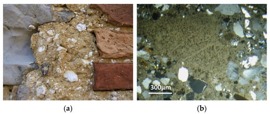
Figure 2.
(a) Lime inclusions, that macroscopically show a whitish appearance, sometimes inconsistent, generically defined as “lumps”, in a mortar from Monte Cetona (Tuscany, Italy); (b) Under-burnt lime fragment referred to a micritic marly limestone (image at the optical microscope in thin section, crossed polarized light).
Concerning the lumps, their presence reveals that the lime was produced with traditional technologies consisting of both putting the quick lime clods in contact with abundant water, followed by aging of the lime putty or according to the hot-mixed (“dry-slaked”) technology where quicklime is mixed directly with wet sand and is not aged as a putty prior to mortar manufacture.
The observation in thin sections allows for recognising the nature of the lumps, referring them to the following types [17]:
- lumps of binder not mixed in the paste;
- under-burnt fragments (relict of under-burnt carbonate rock);
- over-burnt carbonate rock fragments;
- hydrated and carbonated over-burnt fragments after the setting reaction of the mortar;
- lime putty carbonated prior to use (i.e., lime crust above the aging pit).
According to this classification, the study of the under-burnt fragments allows for recognising the type of carbonate rock burnt in the kiln, as reported by several authors (Figure 2b) [16,18,19].
An example is given by the under-burnt fragments of marly limestone (Pietra Alberese) present in the ancient Florentine mortars (see Figure 2b), showing that such binder is slight hydraulic (due to the presence of a small percentage of clay minerals < 10%).
Other examples are given by the under-burnt fragments of metamorphic limestone (marble) typical of the mortars of Val d’Aosta, the under-burnt fragments of the siliceous limestone from Umbria, etc. [20,21].
As mentioned above, the presence of lumps can always be referred to traditional technologies to produce lime. Their surplus, however, indicates a poor production technology or the hot lime technology.
In particular, the type of lumps shows what stage of the production cycle was not cured. Lumps of “under-burnt” indicate a strong inhomogeneity in the distribution of the temperature in the kiln, a lack of adequate sieving of the lime after slaking and a difficulty in the calcination of the stone because of its composition (e.g., too marly). Lumps of “over-burnt” also indicate, in this case, an inhomogeneity of temperature in the kiln and scarce attention in the slaking process (lack of adequate sieving of the lime putty after slaking, not adequate aging, hot lime technology).
Lumps of binder not mixed in the paste may indicate, as previously mentioned, an early carbonation of the lime putty but also heterogeneity present within the limestone with different hydration times. Nevertheless, information about the original carbonate rock as a raw material for the lime can also be obtained by the observation of the binder texture.
Indeed, the presence of rounded radial structures and hydromagnesite recrystallisations inside the porosity indicate the use of dolomitic rocks for the production of lime [20] while the presence of newly formed phases in the form of small dark inclusions and remnants of clinker [22] are instead characteristic both of natural hydraulic limes and of modern hydraulic binders. For each case study, 10 samples of bedding mortars and renderings were examined.
Sampling was carried out with the aid of a small chisel that allowed the extraction of samples of approximately 2 cm3. Care was taken to select areas that had not undergone restoration work through a careful stratigraphic reading of the masonry. For each sample, a part was used to make a thin section on which to carry out the petrographic study. The remaining part was ground in an agate mortar for X-ray diffraction analysis. The thin sections were made by a private laboratory specialized in this type of work.
Only a mineralogical–petrographic study was carried out because, although sophisticated techniques provide excellent information, only a careful petrographic investigation, in many cases, allows the most useful information to be obtained in an economical and simple manner. The following instrumentation was used:
- -
- the mineralogical composition was determined using a PANalytical X’PertPRO diffractometer with CuK1 = 1545 Å radiation, operating at 40 KV, 30 mA, investigated range 2θ = 3–70°, equipped with an X’ Celerator multidetector and High Score data acquisition and interpretation software.
- -
- the petrographic study was carried out on thin sections (30 microns thick) observed under a transmitted polarised light optical microscope (ZEISS Axioscope. A1 equipped with a camera [5-megapixel resolution].
4. Case Studies
4.1. The Island of Capraia
Capraia, the westernmost island of the archipelago, with a surface of 19 km2, was formed as a result of two distinct eruptive periods. In fact, the main part of the island consists of a complex of domes fed by calk-alkaline magmas high in potassium put in place during the Miocene (7.7–7.5 Ma) in four distinct eruptive phases. A small part of the island, the Zenòbito area, was characterised by an eruption of shoshonitic lavas during the Pliocene (4.7 Ma) (Figure 3) [23].
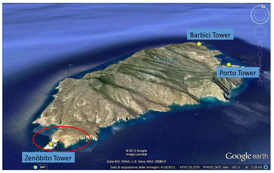
Figure 3.
The Capraia island with the localisation of the three towers studied. The red circle indicates the Zenòbito shoshonitic volcanic event dating to the Pliocene (4.7 Ma) (from Google Earth (4 October 2013), 43°01′25.23″ N, 9°49′01.56″ E, Eye alt. 2.28 Km, Landsat, SIO, NOAA, U.S. Navy, NGA, GEBCO 2013, [5], modified).
The island belonged to the Republic of Genoa from the 14th century to the end of the 18th century. During that period, after the destruction perpetrated by the Ottoman corsair Dragut in 1540, the Banco di San Giorgio supported the renovation and expansion of the fortress built by the Pisans (St. George fortress) and the construction of the towers of Porto (1541) to defend the bay and prevent the landing of enemy ships (Figure 4), and of Zenòbito (1545) in the southern tip of the island.
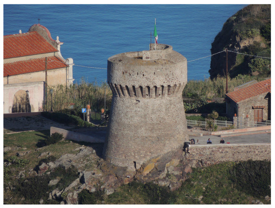
Figure 4.
The Porto Tower, near Capraia village, recently restored.
Later, the tower of Barbìci was built in the northern tip (1699) with the function to watch over the sea toward the Tuscan coast. The island was in fact a strategic point on the route of Corsica–Genoa.
The petrographic observation of the mortars (bedding mortars and rendering) of these three towers points out the presence in the binder of rounded radial structures together with recrystallisations inside the porosity, both to be referred to hydromagnesite (Figure 5a) as confirmed by the mineralogical analysis through X-ray diffraction.
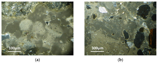
Figure 5.
(a) Rounded radial structures of hydromagnesite indicating the magnesian nature of the binder (image at the optical microscope in thin sections, crossed polarised light); (b) Under-burnt fragments of a dolomitic rock (image at the optical microscope in thin section, crossed polarised light).
This indicates that we are in the presence of a magnesian binder obtained from the burning of dolomite/magnesian limestones. Indeed, this is confirmed by the presence of under-burnt fragments of dolomitic rocks (Figure 5b) [24].
This high number of lumps (Figure 6), the excellent mechanical characteristics and good adhesion to the masonry elements may indicate that for the realisation of the mortar, the technique of the hot lime was adopted [25,26,27].
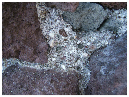
Figure 6.
The high number of lumps in the bedding mortars of the Zenòbito Tower may indicate the technique of the hot lime in the realisation of mortars.
Actually, in Liguria, from the 13th century a highly specialised lime production system developed [28] due to the presence of dolomite rock outcrops near the coast (Sestri Ponente, Cogoleto, Vado Ligure) and to the consequent possibility of carrying the lime by sea, cost-effective even in distant sites.
The clods of quicklime obtained by burning were stored in wooden barrels and transported by mule to the beach, where they were loaded into boats conducted by sailors at the service of the lime producers. It was therefore reasonable to assume that the lime for the construction of the fortifications of Capraia and of many coastal towers of Corsica (an island relatively poor of carbonate outcrops, in Genovese possession at the time,) arrived from Liguria [29].
Confirmation of the provenance of lime from Liguria is also the presence in the mortar of sporadic fragments of calcschists, quartzites and phyllites, characteristic of the regional metamorphism of HP-LT conditions, similar to that of the Ligurian–Piedmontese metamorphic units (Schistes Lustrés), of which the closest outcrops are in north-eastern Corsica and in Gorgona island, but which widely crop out further away to the west of Genoa, nearby the outcrops of the dolomite rocks [30,31,32].
Sandy debris of these rocks could have been transported on board unintentionally during loading from the beach.
4.2. The Island of Gorgona
The island of Gorgona is the northernmost island of the archipelago and the smallest, with a surface of 2.24 km2. To the northeast, the geological structure of the island consists of a complex of metabasites and metagabbros derived from an oceanic crust and to the south-west of metasedimentary formations covering the oceanic crust (calcschists and prasinites) (Figure 7) [32,33,34].
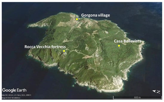
Figure 7.
The Gorgona island with the localisation of Rocca Vecchia (from Google Earth (10 August 2019), 43°28′04″ N, 9°54′59″ E, Eye alt. 3.27 Km, TerraMetrics, SIO, NOAA, U.S. Navy, NGA, GEBCO 2023, [5], modified).
In particular, the calcschists cover most of the island. From a geological point of view, the island is considered the easternmost buttress of the Alps, just west of the first Apennine outcrops on the Tuscan coast, although radiometric dating of the HP-LT metamorphism indicates an age of about 25 Ma; therefore, it is referable to the Apennine orogeny rather than the Alpine orogeny which has a terminal age of about 35 Ma [35].
The island Gorgona was frequented in Etruscan times and inhabited in Roman times; in fact, at the Piano dei Morti locality the ruins of a building from the late Republican period are visible. In the 5th century AD, hermit monks founded the monastery of St. Maria and St Gorgonio.
The island was then inhabited intermittently in the 12th–13th centuries and subjected to frequent barbarian invasions. Monks and small military garrisons resisted, guarding the island until the 17th century. After a period of abandonment in 1869, an agricultural penal colony was established, still active today.
The mortars that were exanimated (bedding mortars and plasters) come from the Rocca Vecchia Fortress, dominating the island from a rocky spur constituted by the local calcschists on the western side, at about 200 metres a.s.l., and currently in a state of ruin (Figure 8).
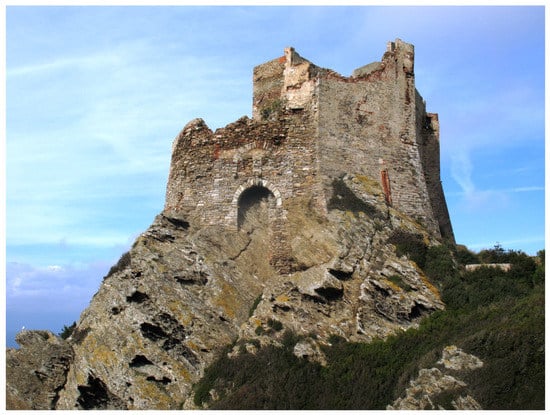
Figure 8.
The Rocca Vecchia fortress dominating Gorgona from a rocky spur on the western side of the island.
It was built by the Republic of Pisa and dates to the 13th century, but it seems that the settlement was originally represented by a single tower dating back to the 11th century. Around this structure, still identifiable in the current structure, other parts were added up to give it a polygonal and asymmetrical plan, with three quarters of the perimeter exposed on a cliff overlooking the sea. The fortress played an important role in protecting the borders of the Pisan Republic. In fact, its strategic position made it possible to control a large part of the Corsica Channel. The fortress also carried out its defensive functions during the period of Florentine rule until it became part of the agricultural penal colony in 1800.
The petrographic observation of the mortars belonging to the first construction phase of the fortress evidenced the presence of under-burned marble fragments (Figure 9a).
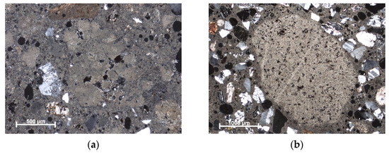
Figure 9.
(a) Bedding mortar with an under-burnt fragment of marble in the centre of the image (local origin) (image at the optical microscope in thin section, crossed polarised light); (b) Bedding mortar with an under-burnt fragment of micritic limestone (image at the optical microscope in thin section, crossed polarised light).
This made it possible to confirm what was reported in the historical sources regarding a local supply for the production of lime. Indeed, a local supply to produce lime was not so easy because on the island there are only limited outcrops of suitable carbonate rocks. This has been evidenced by the most recent geological study of the island [32] revealing the presence of sporadic outcrops of marbles, such as a layer 5 metres thick, of massive to listed, locally saccharoidal marble body, whitish to dark grey in colour, intercalated within the calcschists near to Casa Bellavista where the remains of an ancient kiln are reported.
Being able to produce lime directly on the island denotes the remarkable skill in the search for a local supply of raw materials rather than having to bring them from the mainland, probably also dictated by the difficulty of communication with the mainland.
Concerning the mortars of the more recent construction phases, the presence of under-burnt micritic marly limestone fragments was highlighted (Figure 9b), indicating the origin of the lime from the Tuscan coast. The use of this lime is justified by the greater ease of communication with the mainland under the Florentine rule.
4.3. The Island of Giglio
Giglio island, with a surface of 21 km2, is sited in the southern part of the archipelago, in the stretch of sea facing the Argentario promontory. In total, 90% of its extension is made of a monzogranite intrusion dated 5 Ma [36].
The only part of the island not made up of plutonites is that of the Franco promontory, in the western side of the island (8.5% of the island territory) (Figure 10).
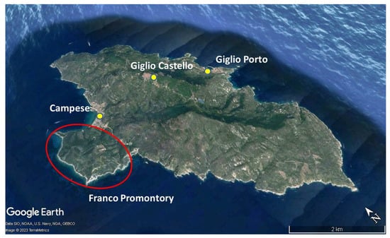
Figure 10.
The Giglio island with the localisation of Franco Promontory (red circle), the part of the island made up of sedimentary rocks and ophiolites (from Google Earth (August 10, 2019), 42°39′09″ N, 10°54′48″ E, Eye alt 13.96 Km, TerraMetrics, SIO, NOAA, U.S. Navy, NGA, GEBCO 2023, [5], modified).
In this area, metamorphic and sedimentary Mesozoic rocks crop out, referable to two distinct tectonic units. The upper unit, consisting of metagabbros, schists with glaucophane, prasinites and chloritic-schists [37,38] and the lower unit consisting of marbles that are light grey to whitish with medium to thick beds, dolostone, cavernous limestone (a grey to dark grey, vacuolar calcareous and calcareous dolomitic breccias with local karst structures), quartz conglomerates and quartzites of the Verrucano formation [38,39,40]. This succession is similar to that constituting the structure of the nearby Monte Argentario.
The island was inhabited since the Iron Age. Under the Roman rule was a fairly important base in the Tyrrhenian Sea and residence of the noble Domizi Enobarbi family (one of their villas is at Giglio Porto, slightly below sea level). Moreover, the Romans exploited the island for granite extraction [41]. In the Middle Ages, it came under the rule of the Aldobrandeschi family, then entered the domain of Pisa (from 1264 to 1406) and later passed to the Medici of Florence, who, after the pillage and deportation perpetrated by the Ottoman corsair Khayr al-Din Barbarossa, repopulated the island with people from the Sienese lands. In the 12th century, the Aldobrandeschi built the village of Giglio Castello on the heights of the island, at an altitude of 405 metres a.s.l., incorporating the pre-existing Rocca and surrounding it with walls interspersed with towers, which were further fortified during Pisan rule (Figure 11).
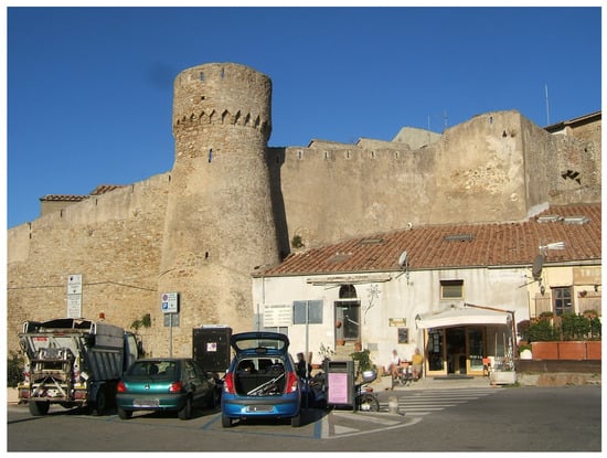
Figure 11.
Giglio Castello: the walls of the 16th century, built with granite ashlars.
During the Renaissance period, the Medici had to carry out major restoration work on this defensive structure following various pirate raids.
In this research, it was not possible to take samples from the bedding mortars of the Rocca Aldobrandesca or from the defensive walls, representative of the original materials, due to the many restorations undergone.
Nevertheless, it was possible to take samples (bedding mortars and renders) from the “palmenti”, masonry structures of modest dimensions built in the 1500s–1700s for the pressing of grapes (Figure 12a).
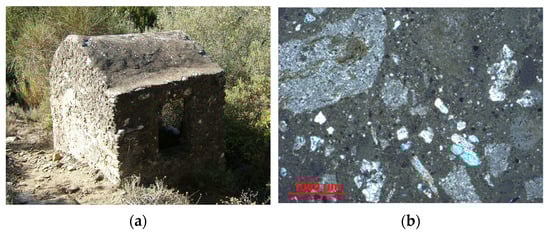
Figure 12.
(a) “Palmento”, masonry structures of modest dimensions for the pressing of grapes, from where mortar samples were taken. (b) Bedding mortar of a “palmento” with dolostone and marble fragments in the aggregate (image at the optical microscope in thin section, crossed polarised light).
Inside and outside of them, there are one or more vats, sometimes carved directly into the granite. In the first, the grapes were pressed with the feet; in the second, located lower down and connected by a hole, the must was collected. Through a second hole, placed at the lowest point of the second vat, the must was collected in goatskin and carried by donkey to the cellars of the village.
The petrographic observation of the mortars points out both the use of dolostone and marbles to produce the lime (Figure 12b).
The use of dolostone and marble for the production of lime is testified in some samples by the presence of under-burnt fragments and of rounded radial structures and recrystallisations inside the porosity to be referred to hydromagnesite. These carbonate rocks are present in the Franco Promontory.
Indeed, a local production of the lime is attested by a document from 1808 in which the Prefect of the department of Ombrone asks the chancellor of Giglio G. Baiocchi about land taxes. The chancellor replies that in the Community of Giglio, unlike other territories of Tuscany, the people are not taxed for many commercial activities (mills, slaughterhouse, taverns, etc.) but are taxed for the income from the lime kilns. Moreover, in the Campese locality, near the Franco Promontory, there is the toponym “La Fornace” (The Kiln) [42].
5. Conclusions
The study addressed the problem of lime supply on three islands of the Tuscan archipelago, Capraia, Gorgona and Giglio, where carbonate rocks are absent or present in very limited outcrops. Mineralogical–petrographic analytical methodologies were used for this purpose.
Interesting is the case of Capraia where the use of a magnesian lime from Liguria has been verified as evidenced by the particular texture of this kind of binder and by the presence of hydromagnesite. This use can be referred to the period when the island was a possession of the Republic of Genoa (until the end of the 18th century).
For Gorgona, in the Middle Ages the monks living on the island had calcined carbonate material from thin marble outcrops, as evidenced petrographically by the presence of under-burnt marble fragments inside the mortars. Later, however, lime arrived from the nearby Tuscan coast, obtained by burning marly limestone.
Regarding Giglio, the petrographic observation points out both the use of dolostone and marbles as a raw material to produce lime. These rocks are present in small outcrops in the western side of the island and local production is attested by documents and toponym. Then, just as each island has its own geological peculiarity, the lime also differs and contributes to making each island unique in a world that tends to a complete homologation, thereby losing the material culture of each territory.
Furthermore, the study highlighted the importance of historical and toponymic information in supporting and validating the scientific investigation. Indeed, it made it possible to contextualise the use of raw materials within the historical and administrative events of the places. This work showed the inhabitants’ profound knowledge of their territory and their ability to adapt and exploit its resources.
Moreover, the study wanted to show how a simple and inexpensive technique, such as the mineralogical–petrographic survey, can provide most of the useful information for the purposes of this research.
Author Contributions
All authors, namely S.R., F.F. and D.P., are to be considered principal authors because they contributed to the conceptualisation, writing, original draft, revision and editing. All authors have read and agreed to the published version of the manuscript.
Funding
This research received no external funding.
Institutional Review Board Statement
Not applicable.
Informed Consent Statement
Not applicable.
Data Availability Statement
The data presented in this study are available in the References reported at the end of this paper.
Conflicts of Interest
The authors declare no conflict of interest.
References
- Montana, G.; Randazzo, L.; Ventura Bordenca, C.; Giarrusso, R.; Baldassari, R.; Polito, M. The production cycle of lime-based plasters in the Late Roman settlement of Scauri, on the island of Pantelleria, Italy. Geoarchaeology 2018, 34, 631–647. [Google Scholar] [CrossRef]
- Walker, H.J. Coral and the Lime Industry of Mauritius. Geogr. Rev. 1962, 52, 325–336. [Google Scholar] [CrossRef]
- Rosenbaum, G.; Lister, G.S. Neogene and quaternary rollback evolution of the Tyrrhenian Sea, the Apennines, and the Sicilian maghrebides. Tectonics 2004, 23. [Google Scholar] [CrossRef]
- Peccerillo, A. Cenozoic volcanism in the Tyrrhenian Sea Region. In Advances in Volcanology, 2nd ed.; Nemeth, K., Ed.; Springer International Publishing: Cham, Switzerland, 2017. [Google Scholar] [CrossRef]
- Available online: https://earth.google.com (accessed on 5 May 2023).
- Carmignani, L.; Conti, P.; Cornamusini, G.; Meccheri, M. The internal Northern Apennines, the Northern Tyrrhenian Sea and the Sardinia-Corsica Block. In Geology of Italy; Crescenti, U., D’Offizi, S., Merlino, S., Sacchi, L., Eds.; Società Geologica Italiana: Bologna, Italy, 2004; pp. 59–77. [Google Scholar]
- Mantovani, E.; Babbucci, D.; Tamburelli, C.; Viti, M. A review on the driving mechanism of the Tyrrhenian–Apennines system: Implications for the present seismotectonic setting in the Central-Northern Apennines. Tectonophysics 2009, 476, 22–40. [Google Scholar] [CrossRef]
- Aringoli, D.; Coltorti, M.; D’Orefice, M.; Dramis, F.; Federici, P.R.; Foresi, L.M.; Graciotti, R.; Iotti, A.; Molin, P.; Moretti, S.; et al. Geomorphological Map of the Tuscan Archipelago. Mem. Descrittive. Carta Geol. D’italia 2009, 86, 7–107. [Google Scholar]
- Dini, A.; Gianelli, G.; Puxeddu, M.; Ruggieri, G. Origin and evolution of Pliocene–Pleistocene granites from the Larderello geothermal field (Tuscan Magmatic Province, Italy). Lithos 2005, 81, 1–31. [Google Scholar] [CrossRef]
- Gandin, A.; Giamello, M.; Guasparri, G.; Mugnaini, S.; Sabatini, G. The Calcare cavernoso of the Montagnola senese (Siena, Italy): Mineralogical-petrographic and petrogenetic features. Mineral. Petrogr. Acta 2000, 43, 271–289. [Google Scholar]
- Moeller, S.; Grevemeyer, I.; Ranero, C.R.; Berndt, C.; Klaeschen, D.; Sallares, V.; Zitellini, N.; de Franco, R. Early-stage rifting of the northern Tyrrhenian Sea Basin: Results from a combined wide-angle and multichannel seismic study. Geochem. Geophys. Geosyst. 2013, 14, 3032–3052. [Google Scholar] [CrossRef]
- Torfstein, A.; Steinberg, J. The Oligo-Miocene closure of the Tethys Ocean and evolution of the proto-Mediterranean Sea. Sci. Rep. 2020, 10, 13817. [Google Scholar] [CrossRef]
- Decandia, F.A.; Lazzarotto, A.; Liotta, D. Structural features of Southern Tuscany, Italy. Ofioliti 2001, 26, 287–300. [Google Scholar]
- Bugini, R.; Toniolo, L. La presenza di grumi bianchi nelle malte antiche: Ipotesi sull’origine. Arkos Sci. Restauro 1990, 12, 4–8. [Google Scholar]
- Hughes, J.J.; Cuthbert, S.J. The petrography and microstructure of medieval lime mortars from the west of Scotland: Implications for formulation of repair and replacement mortars. Mater. Struct. 2000, 33, 594–600. [Google Scholar] [CrossRef]
- Hughes, J.J.; Leslie, A.B.; Callebaut, K. The petrography of lime inclusions in historic lime-based mortars. Ann. Geol. Pays Hell. 2001, 39, 359–364. [Google Scholar]
- Pecchioni, E.; Fratini, F.; Cantisani, E. Atlas of the Ancient Mortars in Thin Section under Optical Microscope; Quaderni di Kermes Nardini Editore: Florence, Italy, 2014. [Google Scholar]
- Fratini, F.; Pecchioni, E.; Cantisani, C. The petrographic study in the ancient mortar characterization. In HMC08, Historical Mortars Conference: Characterization, Diagnosis, Conservation, Repair and Compatibility; LNEC, Laboratorio General Engenharia Civil: Lisbon, Portugal, 2008. [Google Scholar]
- Pavía, S.; Caro, S. Lime mortars for masonry repair: Analytical science and laboratory testing versus practical experience. In Proceedings of the International Seminar Theory and Practice in Conservation—A Tribute to Cesare Brandi; Delgado Rodrigues, J., Mimoso, J.M., Eds.; Laboratorio Nacional de Engenharia Civil: Lisbon, Portugal, 2006; pp. 493–500. [Google Scholar]
- Milanesio, E.; Storta, E.; Gambino, F.; Appolonia, L.; Borghi, A.; Glarey, A. Petrographic characterization of historic mortar as a tool in archaeologic study: Examples from two medieval castles of Aosta Valley, Northwestern Italy. J. Archaeol. Sci. Rep. 2022, 46, 103719. [Google Scholar] [CrossRef]
- Fratini, F.; Cantisani, E.; Pecchioni, E.; Pandeli, E.; Vettori, S. Pietra Alberese: Building Material and Stone for Lime in the Florentine Territory (Tuscany, Italy). Heritage 2020, 3, 1520–1538. [Google Scholar] [CrossRef]
- Campbell, D.H. Microscopical Examination and Interpretation of Portland Cement and Clinker; Portland Cement Association: Washington, DC, USA, 1999; ISBN 08931-084-7. [Google Scholar]
- Aldighieri, B.; Groppelli, G.; Norini, G.; Testa, B. Capraia Island: Morphology and geology of a complex volcanic activity during the Miocene and Pliocene. In The Regione Toscana Project of Geological Mapping-Case Histories and Data Acquisition; Moretti, D., Bruni, P., Eds.; Regione Toscana: Florence, Italy, 2004; pp. 51–59. [Google Scholar]
- Fratini, F.; Pecchioni, E.; Pittaluga, D.; Pandeli, E. How archeometry can help history and geology: The case of the Genoese towers in Capraia Island. In Defensive Architecture of the Mediterranean XV to XVIII Centuries-FORTMED 2016; Verdiani, G., Ed.; DidaPress: Florence, Italy, 2016; Volume 4, pp. 249–254. [Google Scholar]
- Kraus, K.; Wisser, S.; Knöfel, D. Über das Löschen von Kalk in der 18 Jharunderts: Literaturswertung und Laborversuche. Arbeitsbätter Restaur. 1989, 1, 206–221. [Google Scholar]
- Foster, A. Hot lime mortars: A current perspective. J. Archit. Conserv. 2004, 10, 7–27. [Google Scholar] [CrossRef]
- Copsey, N.; Gourley, B. Hot-mixed lime mortars. In Proceedings of the 3rd Historic Mortars Conference HMC13, Glasgow, UK, 11–13 September 2013; University of the West of Scotland: Glasgow, UK, 2013. [Google Scholar]
- Vecchiattini, R. La Civiltà Della Calce: Storia, Scienza e Restauro; De Ferrari: Genova, Italy, 2009. [Google Scholar]
- Moresco, R.; Fascicolo, I. Atti della Società Ligure di Storia Patria; Moresco, R., Ed.; Società Ligure di Storia Patria: Genova, Italy, 2007; Volume 47. [Google Scholar]
- Durand Delga, M. Corse. In Guides Géologiques Régionaux; Masson Ed.: Paris, France, 1978. [Google Scholar]
- Durand Delga, M. Principaux traits de la Corse Alpine et corrélations avec les Alpes Ligures. Mem. Soc. Geol. Ital. 1984, 28, 285–329. [Google Scholar]
- Orti, L.; Morelli, M.; Pandeli, E.; Principi, G. New geological data from Gorgona Island (Northern Tyrrhenian Sea). Ofioliti 2002, 27, 133–144. [Google Scholar]
- Capponi, G.; Giammarino, S.; Mazzanti, R. Geologia e morfologia dell’Isola di Gorgona. Quad. Mus. Stor. Nat. Livorno 1990, 2, 115–137. [Google Scholar]
- Carmignani, L.; Lazzarotto, L. Carta Geologica della Toscana (Scala 1: 250.000); Litografia Artistica Cartografica: Florence, Italy, 2004. [Google Scholar]
- Rossetti, F.; Faccenna, C.; Jolivet, L.; Funiciello, F.; Goffé, B.; Tecce, F.; Brunet, C.; Monié, P.; Vidal, O. Structural signature and exumation P-T-T path of the Gorgona Blueschist sequence (Tuscan Archipelago, Italy). Ofioliti 2001, 26, 175–186. [Google Scholar]
- Westerman, D.S.; Innocenti, F.; Tonarini, S.; Ferrara, G. The Pliocene intrusion of Giglio Island. Mem. Soc. Geol. Ital. 1993, 49, 345–363. [Google Scholar]
- Biancone, M.; Tucci, P. The ophiolite rocks of Giglio Island (Tuscan Archipelago). Ofioliti 1984, 9, 321–336. [Google Scholar]
- Capponi, G.; Cortesogno, L.; Crispini, L.; Gaggero, L.; Giammarino, S. The Promontorio del Franco (island of Giglio): A blueschist element in the Tuscan archipelago. Atti Ticinesi Di Sci. Della Terra 1997, 39, 175–192. [Google Scholar]
- Lazzarotto, A.; Mazzanti, R.; Mazzoncini, F. Geology of the Argentario Promontory (Grosseto) and the Franco Promontory (Isola del Giglio-Grosseto). Boll. Soc. Geol. Ital. 1964, 83, 1–124. [Google Scholar]
- Decandia, F.A.; Lazzarotto, A. Le unità tettoniche del Monte Argentario (Toscana meridionale). Mem. Soc. Geol. Ital. 1981, 21, 385–394. [Google Scholar]
- Fratini, F.; Rescic, S.; Cuzman, O.A.; Pierattini, P. The alteration of Giglio Island Granite: Relevance to the conservation of monumental architecture. Appl. Sci. 2022, 12, 4588. [Google Scholar] [CrossRef]
- Available online: https://www.isoladelgiglio.net/giglionet/storia_famiglie.php (accessed on 5 May 2023).
Disclaimer/Publisher’s Note: The statements, opinions and data contained in all publications are solely those of the individual author(s) and contributor(s) and not of MDPI and/or the editor(s). MDPI and/or the editor(s) disclaim responsibility for any injury to people or property resulting from any ideas, methods, instructions or products referred to in the content. |
© 2023 by the authors. Licensee MDPI, Basel, Switzerland. This article is an open access article distributed under the terms and conditions of the Creative Commons Attribution (CC BY) license (https://creativecommons.org/licenses/by/4.0/).