Abstract
Bohemian Switzerland is a national park in Northern Czechia famous for its sandstone rocks, which were affected by a massive fire in 2022. Specific geomorphology of the region affected the spreading of the fire and complicated its extinguishing. The fire directly or indirectly damaged several geosites in Bohemian Switzerland. The catastrophe brought a possibility of showing the unique connection between geoheritage and present climate change and increasing awareness about the problems. The text is focused on field education of geography, striving to strengthen environmental awareness among students through educating their teachers. The research is based on desk research, field observation and didactic principles application. The causes of the fire were complex, including physical geographical (drought and bark beetle calamity within climate change) and human geographical phenomena (mass tourism and tourist misbehavior, inappropriate forestry practices). The teachers we worked with reached similar conclusions at the end of our course. Our fieldwork educational concept proved viable and was appreciated by them mainly thanks to the incorporation of research-based learning and the absence of unnatural emphasis on climate change. Climate change is a politicized topic, bringing controversies to the classrooms in the peripheral region. The approach we proposed is anchored in inquiry-based methods and touches on the issue indirectly.
1. Introduction
Geosites, sites recognized for their geological or geomorphological value, face various threats. Preserving these geosites is crucial for safeguarding geoheritage (as the group of geosites), encompassing scientific, educational, tourism, and other purposes. Geosites can provide crucial evidence of past as well as ongoing climate change [1,2,3,4]. Picture a geosite distinguished by its significant scientific value concerning regional geological changes capable of causing alterations in bedrock lithology or structures spanning millions of years (i.e., the geological time scale). When examining a shorter time frame, such as the human time scale, both exogenous factors (e.g., climate-related changes and disasters such as wildfires) and endogenous processes (e.g., volcanic eruptions or earthquakes) can also bring about sudden and abrupt modifications, impacting, among other aspects, the relief’s morphology [5].
Geosites often contain unique geological features and formations that can record changes in climate over long periods of time. For instance, ice cores from glaciers, preserved in geosites, can provide a historical record of atmospheric conditions, revealing patterns of climate change. Similarly, sediment layers in geosites can indicate changes in temperature and precipitation. In some cases, geosites are deeply affected by climate change. Rising temperatures can lead to the melting of glaciers, altering the landscape of these geosites. Changes in precipitation patterns can result in increased erosion or flooding, impacting the geological formations within these sites. Furthermore, the biodiversity within geosites can also be affected by climate change, with shifts in species distributions and populations indicating changes in climate. For example, changes in plant species in a geosite can indicate shifts in temperature and rainfall. Therefore, geosites serve as important monitors of climate change, providing tangible evidence of its impacts and raising awareness about the problem [6,7,8]. Explaining climate change can then rely on the elements of geodiversity (minerals, rocks, soils, landforms, and active geological processes). However, the very changes they record also threaten their preservation, underscoring the urgency of climate change mitigation efforts. This article is primarily devoted to the topic of the influence of climate change on the Bohemian Switzerland National Park (BSNP), which is one of the most valuable geoheritage in Czechia. The BSNP includes several valuable geosites.
The BNSP wildfire of 2022, one of the worst forest fires in the history of Czechia, was a significant catastrophe that had far-reaching implications for both the region’s unique ecosystem and the communities residing within it. This fire, which raged from 23 July to 12 August 2022 on Czech territory and until 19 August on German territory, resulted in the burning and damage of a 16 km2 area. In the largest deployment, eight helicopters, five airplanes, and a total of about 700 people extinguished it. It led to the evacuations of tens of tourists and local inhabitants. Its detailed circumstances and consequences are described in Section 2.2. BSNP, situated on the Czech-German border, is renowned for its natural beauty and ecological significance, highlighted by the existence of the national park. It is also crucial for locals as a long-term popular tourist attraction [9,10]. (Geo)tourism is an important source of income in the peripheral border area of former Sudetenland, with high unemployment and negative social phenomena still linked to the massive population change in the region after World War II [11].
Czechia is known as a state with many climate skeptics denying climate change or man’s influence on it [12]. The most famous and loud climate skeptic is former Czech president Václav Klaus [13]. The climate skeptic attitudes are supported by the geographic location in Czechia, which is unaffected by significant natural disasters. The drought that has emerged in Czechia in the years 2015–2020 is bagatelized by the skeptics. However, the weather and wildfire statistics are difficult to dispute [14,15,16,17]. Some of them indicate the connection between climate change and the increased incidence of fires. The fire endangering emblematic Pravčická Gate, the main tourist attraction in the BSNP, epitomized a wake-up call for climate skeptics in Czechia, particularly Northern Czechia. Based on socioeconomic and electoral statistics and general belonging to the territory of former Sudetenland and the disruption of the age-long relationship with the landscape [18], we suppose that the region has an above-average share of climate skeptics in terms of Czechia. The catastrophe affecting their businesses or jobs might disrupt their lack of interest in climate change. It can also be an excellent example of the visible influence of climatic change on the Czech landscape.
There is little scientific text about the fire in the BSNP because it emerged a year ago. However, the only Czech study [19] is very comprehensive and detailed. Frequent extreme weather brings natural disasters such as droughts and wildfires. We anchor our text in articles about the past decade’s drought and fires in Czechia [14,15,16,20] and texts characterizing the BSNP and regional geology [9,10,21,22,23,24]. Several articles described geological (geographical) fieldwork and its specifics [25,26] and teaching about climate change [27,28,29].
We, as geographers, strive to prepare summer outdoor educational activities indirectly focused on the impact of climatic change on the wildfire, with a particular focus on geoheritage. Fieldwork activities are primarily intended for teachers to inspire them to explain several vital processes to their pupils. The main goal is to introduce the phenomenon of climatic change to the teachers quietly (through analyzing various reasons for the wildfire) within the concept of place-based learning and related tasks. Moreover, we let teachers prepare the didactic transfer of the subtopics and evaluate our proposed activities. The secondary goal is to bring comprehensive information about the wildfire in the BSNP in 2022, specifically accenting problems of wildfire, climate change, and geoheritage. The research is based on desk research, field observation, and the application of didactic principles (for details, see Section 2.4).
The authors of the text created all listed figures and tables.
2. Materials and Methods
2.1. Region
BSNP is located in Northern Czechia in the Ústecký Region (Kraj) (see Figure 1). It is celebrated for its striking sandstone rock formations that have been sculpted by millions of years of erosion and weathering. The national park is situated within the Elbe Sandstone Mountains, which span across parts of Germany and Czechia and has existed since 2000. Germans call their sandstone area bordering Bohemian Switzerland Saxon Switzerland. Both areas create a twin national park. BSNP encompasses an area of 79.23 km2 and boasts a diverse range of rock formations, including towering cliffs, labyrinthine canyons, and natural rock arches developed on sub-horizontally stratified sandstones. Elevation in the BSNP ranges from 115 to 619 m. Massive rock towers, gates, walls, gorges, cities, and mazes were formed by the erosion of Cretaceous marine sediments that were brought to the surface during the Quaternary period due to Alpine folding. In the Upper Cretaceous period, the entire territory was covered by the sea. At its bottom, sediments up to 1 km thick gradually piled up. The existence of the sea on the BSNP territory points to significant climatic changes in the past, although not so rapid as the current one.
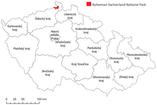
Figure 1.
Location of the Bohemian Switzerland National Park in Czechia.
The bedrock within the BSNP, specifically within the Jizera Formation, consists of robust, nearly horizontal layers of Upper Cretaceous quartz sandstone. These sandstones are predominantly medium to coarse-grained and often feature conglomerate layers with distinct or even erosive boundaries. Quartz makes up the bulk of the sandstone, accounting for 93–98% of its composition. Potassium feldspar constitutes 2–6% of the sandstone, while accessory minerals like muscovite, biotite, and tourmaline are also present. The cement holding the rock together consists of iron oxyhydroxide and clay minerals, primarily kaolinite. Typically, the rock’s surface is covered by a newly formed amorphous SiO2 crust resulting from secondary silicification [10,21,22,23,24]. The natural processes of bedrock erosion and accumulation of sediments as a continuation of the geological development are still active in the BSNP. In addition to weathering, river erosion, deposition, and transport, there are mainly geodynamic slope movements, especially rockfalls (e.g., in the town of Hřensko) [22]. The complete dominance of sandstone in the national park makes its inclusion on its geological map unnecessary.
BSNP can be considered a geoheritage consisting of various geosites. One of the most iconic geosites is the Pravčická Sandstone Gate, which is the largest natural sandstone arch in Europe. Due to its geological structure, geometry, and exposure, the gate faces threats from potential gravitational collapse, strong winds, intense solar radiation, temperature fluctuations, salt erosion, and frost damage [24]. Another gem is the Gorges of the Kamenice River (Ferdinand’s, Edmund’s, and Wild Gorge), containing various formations, overhangs, and tunnels and surrounded by rocks high between 50–150 m. Other attractive geosites include rock cities (Narrow Stairs), viewpoints (Marie’s Rock, Kamenická Viewpoint, Treppenstein, Rudolf’s Stone, and Vilemína’s Wall) and the remains of rock castles (Brtnický Castle, Falkenštejn, Šaunštejn, and Vlčí Castle). The unique geological features make the BSNP a destination for casual tourists, rock climbers, hikers, and photographers. The only geosites with a paid entrance are the Pravčická Sandstone Gate and the Gorges of the Kamenice River, which are partly accessible only by boat. Paid entrance indicates these sites’ value and overtourism threat.
According to Quitt, there are four moderately warm climatic areas and one warm area (in the Elbe Valley) in the BSNP [30]. Nevertheless, it must be emphasized that concerning the relief of the sandstone rock cities and canyon-shaped valleys, the determining factors for the BSNP are microclimatic conditions, which, especially in extreme locations, fundamentally differ from macroclimatic ones. A typical manifestation of the microclimatic conditions is a climatic inversion, which manifests itself in the vegetation of these areas in the form of the so-called reversal of vegetation degrees. Microclimatic factors also indirectly influence capillary water transport and the consequent subsurface degradation of sandstone. Sandy soils in the region are poor in nutrients and acidic [20]. The air quality in the BSNP is mainly affected by the relief when some parts are located in a predominantly deep and poorly ventilated valley with poor dispersion conditions exacerbated by the occasional penetration of emissions from the industrial Ústí nad Labem area.
BSNP is the fourth and latest declared national park in Czechia. It was found to protect unique sandstone geomorphology and diverse ecosystems. It is segmented into three conservation zones (primarily the core, followed by the second and third zones). These zones are determined based on the allowable extent and nature of human activities within them. The most well-preserved geosites of the park, such as Pravčická Gate or Gorges of the Kamenice River, are encompassed within the core zone, where human presence theoretically faces the most stringent restrictions—for instance, individuals are only permitted to walk along designated tourist trails. The initial zone encompasses approximately 25% of the park’s total area. Over 70% of the park falls within the second zone, characterized by areas often planted with artificial monocultures of coniferous trees (spruces and pines). The third zone comprises the least-preserved areas, significantly altered by human activities, particularly human settlements and their immediate surroundings, as well as other developed zones. It is important to note that the park lacks a buffer zone. Instead, this role is anticipated to be fulfilled by two lower-level protected landscape areas. The park has 166.4 km of marked tourist trails, including 101.5 km for hiking and 64.9 km for cycling. It is worth mentioning that these trails primarily follow forest roads, many of which are covered with asphalt, making their presence within the protected area relatively prominent [9]. Approximately 8000 inhabitants live in the municipalities in the BSNP. Settlement is uneven, especially in towns (Krásná Lípa, Chřibská) and villages along the national park’s borders.
2.2. Connection of the Fire and Climate Change
It is challenging to prove the direct impact of climate change on the wildfire that the arsonist set. However, the partial findings below indicate a connection. Forest fires have emerged as one of the most devastating natural disasters, with a consistent upward trend in their occurrence over the past century and into the current one [31]. For example, in 2021, Europe witnessed over 44,000 forest fires, collectively ravaging nearly 5000 km2 [16]. In 2022, forest fires across Europe impacted around 8600 km2 [20]. Central Europe belonged to relatively safe regions, but the situation has changed in the last decade [32,33]. Specifically in Germany, during the summer of 2022, approximately 10 km2 of coniferous forests were ablaze in a military zone near Nuremberg. The forest fire in the BSNP aligns with the broader European situation for that year and does not represent an anomaly. Moreover, paleoecologic analysis showed that wildfires have emerged in the region since the paleolite, mainly due to the presence of humans in sandstone rock cities. Fire events are more frequent in forests with a predominance of coniferous tree species (pines and spruces), and the fewest fires were when deciduous forests (beeches) dominated [20].
Rising annual temperatures and prolonged droughts, especially in 2015–2020 [34], have exacerbated the circumstances, making Czechia more susceptible to forest fires [15]. The most pronounced warming and a slight reduction in the amount of precipitation emerge in the summer months. There are more frequent periods of rain-free periods and the occurrence of extreme meteorological phenomena such as floods, torrential rains, droughts with subsequent fires, etc. [35]. According to data from the Statistical Yearbook of the National Fire Rescue Service, in the recent four-year period spanning from 2018 to 2021, Czechia experienced 7594 forest fires, which is nearly equivalent to the total number recorded during the entire decade from 2001 to 2010 [36].
Climate change brings several risks to the BNSP (which can contribute to the occurrence of wildfires) [37]:
- The instability of rocks predisposed by the regional geological structure and morphological conditions in the region and increased erosion (temperature has been demonstrated to be the primary factor influencing the reversible deformation of rock blocks through volumetric changes). This effect can potentially obscure the understanding of the inherent dynamics of slope movement and might even be a contributing factor to the dynamic forces involved in the intrinsic dynamics of slope failure systems [38];
- The shift of vegetation belts, better conditions for spreading pests (especially in spruce monocultures), higher demands for forest restoration, the withering of forest stands in unsuitable habitats, and unsuitable conditions for growing spruce;
- Drought and reduced water supply in the soil, drought stress, river flow reduction, and water resource levels drop;
- Increase in average annual water temperature, faster course of most unwanted chemical reactions and bacterial processes, a decrease of water quality, the influence of oxygen conditions, and changes in communities in watercourses;
- Increased incidence of windstorms endangering especially spruce forests;
- Deterioration of snow conditions.
The wildfire from 2022 (23 July–12 August 2022 on the Czech territory, 19 August on the German territory; see Figure 2 and Figure 3) we are focusing on was the first large fire in the modern history of Czechia, burning and damaging an area of 16 km2. Hruška et al. [19] bring a detailed spatiotemporal description of the fire. In 2023, Czech police caught the arsonist behind the fire, the former voluntary national park ranger. Nevertheless, drought, bark beetle calamity, and meteorological conditions during the fire played a non-negligible negative role. It was the largest but not the first more significant fire in the BSNP. Let us mention fires in 2000, 2003, 2006, and 2012. Small fires emerge every year.
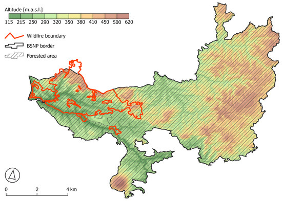
Figure 2.
Map of the Bohemian Switzerland National Park and the territory damaged by the wildfire.
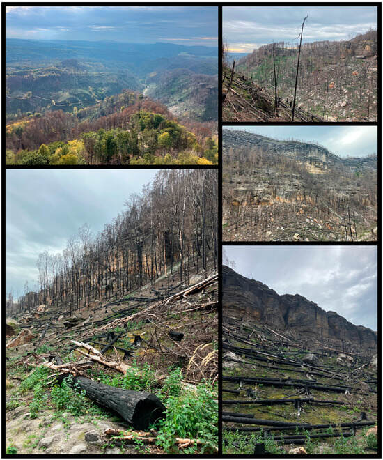
Figure 3.
Photo documentation of the consequences of the forest fire in 2022 (state in the summer of 2023, previously the area was closed to the public).
In the Usti and Labem District, the summer of 2022 experienced temperatures 2.7 °C higher than the long-term average from 1961 to 2000. Nationally, the summer of 2022 ranked the sixth warmest since 1961, with an average temperature of 26.6 °C [19]. The BSNP region has been experiencing an uninterrupted drought since 2018. Additionally, the FAPAR (Fraction of Absorbed Photosynthetically Active Radiation) satellite observations of vegetation conditions confirmed the harmful impact of the drought. The long-lasting drought during the second decade of the 21st century played a significant role in a notably extensive bark beetle outbreak throughout Czechia, including the BNSP area (since the arid year 2015). Between 2018 and 2022, the beetle affected approximately 95% of all spruce trees in the BSNP, affecting roughly 55% of the park’s forested area. Spruce forests in part of the territory have been attacked by bark beetles (since the arid year 2015) and harvested only in places in danger of falling trees (e.g., near roads and hiking trails) and the so-called buffer zone adjacent to other forest owners. The different areas were left for spontaneous development. Bark beetle calamity was seen as a chance to establish and support new, varied, and more stable forests that will better withstand the changing climate, concrete wind disasters, and long-term drought. The fire occurred in an area within the BSNP that an infestation of bark beetle had significantly impacted. Consequently, the majority of the burned region consisted of dead spruce trees.
The BNSP fire distinguished itself from previous fires by substantially deploying firefighting resources. Furthermore, the unconventional and intricate terrain hindered access to heavy firefighting machinery, introducing challenges to the extinguishing efforts. Firefighters first evacuated dozens of tourists and residents of the settlement of Mezná, part of Hřensko. Firefighting teams and helicopters from countries including Poland, Slovakia, Sweden, and Germany also joined the response efforts. Special airplanes, helicopters, drones, and climbing equipment for firefighters were used because of the complicated terrain in the BSNP.
Even in places with the highest fire severity, where the burning temperature was very high for a long time, a significant part of the ecosystem always remained untouched by fire. It was typically about overlying humus horizons, local terrain depressions, massive rock formations, etc. The rocky terrain prevented firefighters’ access and prolonged firefighting. It contained the fire’s spread in the areas of rock walls but boosted the fire in gorges with a specific airflow where the chimney effect could emerge.
High temperature, strong wind, and low humidity combined during the fire episode. The extended period of drought, the widespread presence of bark beetle infestations, and the subsequent buildup of fuel, along with dry fuel conditions, wind speed and direction, and the weather conditions on the day of the fire, all played a role in the rapid spread of the fire. The fire broke out in the challenging-to-reach terrain of the Malinový Gorge, close to Hřensko in the Western part of the park. Its dynamics were evident, with the fire covering a distance of 10 km within four days. The fire outbreaks were sporadic, with instances where the fire rapidly advanced through the air over hundreds of meters [39].
It was found impossible to prevent the wildfire despite narratives among people in the region or Czech media [19], which blamed the national park administration for not removing dry trees. However, research showed that dry trees burn similarly to grass vegetation and the surface of the rake. The fire went through all the vegetation and vegetation types present, but the least damaged were beech forests.
BSNP is a region of extremely drying sandy soils, where the soil surface temperature rises to 60 °C in the summer on the south-exposed clearings and exposed rocks. Intensive firefighting led to soil erosion, denudation, and material deposition resulting from ignition, extinguishing, and associated actions. Soils in the BSNP are acidic, with a small amount of nutrients and a large amount of sand because of constant sandstone erosion [40]. Particularly beneath the rocky outcrops, one can often observe grey-white sand. In some instances, this grey-white sand signifies erosion or the combustion of the upper humus layer due to the fire, its extinguishing, and the exposure of the underlying mineral horizons. Conversely, it frequently represents a porous accumulation of material from adjacent rocky outcrops. Underneath this accumulated material, one can discern the burnt upper and lower humus layers that remained unaffected by the fire.
Burning and extinguishing also impacted the natural disruption of soils by the biomechanical effects of trees, e.g., uprooting. Upheavals are a standard part of the dynamics of temperate natural forests. This is a minor yet significant form of tree mortality in the sandstone area. From the field trip around the fire scene, very few trees were uprooted directly by the fire. The vast majority were uprooted shortly before the fire. Typical for these cases is burning uprooted trunks only up to the edge of the mineral soil, which partially covers it. In any case, the extensive fire deviated from the disturbance regime of the soils and the evolutionary trajectory of their development [19]. The impact on the soils was significant and also affected the geological base. During a fire, relatively high temperatures occur, and if it gets close to rock formations, physical and chemical changes take place in them. The fire, smoke, and extinguishing of the fire also damaged rock outcrops. Burned rocks became discolored or even cracked [41]. The blackening of rocks disappears in exposed locations quickly, but under the overhang, it can remain for a long time. Sandstones are made from multiple minerals that may heat at different rates and may contain defects on the inside, both of which can cause cracks or even explosions. Also, their porous structure with water held inside contributes to explosions. Several rocks in the BSNP were damaged, but fortunately, the geosites mentioned in Section 2.1 were not affected.
Pravčická Gate was in danger. However, there are no trees near it. The problem could have been if the water used in extinguishing got on the rock and increased thermal stress, possibly leading to the fall-off of some less stable parts. Fortunately, Pravčická Gate survived in its original form. Sandstone boulders, mostly smaller, weighing tens to hundreds of kilos, rolled into the valley from where the fires were extinguished. They were apparently washed away by water during the extinguishing process. Because the vegetation on the slopes was burned, they will be more vulnerable. Sandstones can become a little brittle so that they can crumble more, and there can be an increased incidence of rockfalls. On the other hand, because the sandstone is more fragile, such large blocks will not reach the valley because they will break up earlier on the slope.
Damaged environments and rocks are less attractive for mass tourism than before the wildfire (see Figure 4). Moreover, many tourist paths are still closed because of the consequences of the wildfire and the threat of falling trees and rock parts. Specialists check the stability of rocks using sensors, laser measurements, photographs, and direct inspections. Damaged sensors and protective meshes should be replaced.
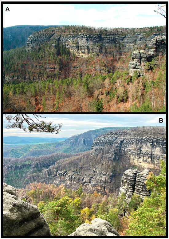
Figure 4.
Photo documentation of the consequences of the forest fire in 2022 at the Dlouhý Gorge rock formation: (A) condition before the fire, (B) state after the fire.
2.3. Geographic Fieldwork Fundamentals
The concept of fieldwork encompasses a multifaceted educational approach that incorporates a diverse array of methods, including experimentation, laboratory activities, observation, project-based learning, cooperative methods, and experiential pedagogy. It also encompasses various organizational structures for teaching, such as field excursions, exercises, walking tours, and thematic school trips or expeditions, all with a primary emphasis on learning outside of the traditional classroom setting [25,26]. Fieldwork engages students in observing natural and social processes, their distribution, and how they manifest within the landscape within a specific curricular content [42]. Furthermore, field education highlights the development of a wide range of essential skills and underscores the educational potential, mainly when focusing on the students’ local surroundings. It complements the facts conveyed through verbal communication in the classroom. In contemporary education, field education is integrated into project days, considered one of the most comprehensive teaching methods. It aims to foster activities that require student participation, information acquisition, critical evaluation, and the presentation of findings.
Field teaching is adaptable to a broad spectrum of geographical topics spanning physical geography, cartography, geoinformatics, and human geography. It can seamlessly bridge connections across various school subjects such as geography, biology, and civic education.
We can distinguish fieldwork [43]:
- In terms of time—short-term (several hours), medium-term, (one-day), and long-term (multi-day) education;Based on the landscape in which the teaching takes place—natural landscape, rural landscape, and urban landscape;
- From the point of view of teaching—teaching is conducted either by pupils, the teacher, or pupils in cooperation with the teacher (similarly, it is also possible to vary the question of teaching evaluation);
- From the point of view of the teaching schedule—teacher preparation in the field and research, the preparatory phase of pupils associated with motivation, involvement in the organization of teaching and familiarization with the place of teaching, the implementation phase in the field and the final phase of task processing, interpretation results and teaching evaluation.
The preparation for field teaching is closely linked to the role of the educator. Typically, the educator identifies a problem or topic with spatial dimensions that pique their interest and then embarks on a field investigation. Their objective is to locate suitable sites for conducting field teaching. To ensure effective field teaching, it is imperative to establish clear, attainable goals that do not overwhelm the learners. This step is crucial for evaluating the effectiveness of the teaching process. From a broader perspective, the authors aim to align their pedagogical approach with the revised Bloom’s taxonomy [44], particularly focusing on the higher cognitive processes dimensions. These higher dimensions are associated with individual and collaborative activities involving problem identification and the development of potential solutions. One of the primary benefits for students is the practical application of geographical knowledge acquired not only within the confines of the traditional classroom setting. Field teaching poses greater challenges for educators regarding time commitment, financial resources, and safety considerations than classroom teaching. However, the authors firmly believe that the aforementioned advantages outweigh these drawbacks. Notably, fieldwork is an integral component of the Framework Educational Program for Basic Education [45] and Framework Educational Program for Grammar Schools [46], pivotal documents within the Czech curriculum, and The 2016 International Charter on Geographical Education [47] created by the International Geographic Union, highlighting sustainability and human responsibility for the natural environment. Nevertheless, the everyday reality of Czech schools might differ, and field teaching rarely emerges in some of them for the abovementioned reasons.
Our approach towards fieldwork is connected to place-based learning (PBL) or place-based education. PBL encompasses educational methods that prioritize hands-on, community-oriented, and context-based education to foster stronger connections to local settings, cultures, environments, and ethics [48,49]. PBL primarily emphasizes active learning approaches that encourage students to become proactive explorers of the various dimensions of their learning and living environments, encompassing culture, ecology, society, politics, and economics. Consequently, PBL is an overarching term for educational methods driven by local, community-based, or ecological principles. This often involves a strong environmental focus, framing PBL as a means to cultivate “environmental citizens” [50]. Knowing a place involves being sensitive to its intricacies and understanding the distinctions and commonalities between that place and others. The concept of place encompasses the narratives of political and economic decisions that affect local areas and shape human life [47]. It highlights the connections between local contexts and broader global trends and offers politically, socially, and ethically engaged perspectives on teaching and learning. The abovementioned aspects are reflected in the four dimensions of PBL [51,52]:
- Biophysical, which pertains to the fundamental physical context of a place;
- Psychological, which concerns an individual’s unique experience within that physical place;
- Socio-cultural, which views a person as an integral part of a specific society and culture with ties to that place;
- Political-economic, which considers the political and economic processes that shape both place and people’s perspectives on it.
Czech curricular documents [45,46] do not mention place-based learning or education. They make only vague references to the local region and its knowledge. That is also why we bring innovative outdoor courses for geography teachers who can apply and spread our approach.
2.4. Methods
The research used several methods, combining field observations, analysis of teacher feedback, and interviews with teachers. Generally, we can state that it encompassed all four dimensions of PBL. The research design took advantage of the fact that five one-week courses for teachers of geography and science and students of teaching (from Bohemian Switzerland and Ústí nad Labem and Liberec Regions) were held in the area of Bohemian Switzerland and its surroundings between May and July 2023 to collect relevant data in an experimental manner. These courses (named summer schools) were attended by a total of 176 respondents. They included additional teacher training in modern teaching methods, the use of digital technologies, research-based teaching, place-based learning, etc.
Within these summer schools, a one-day program was implemented, where the participants had to design research activities analyzing the individual components of the surrounding nature (geology, geomorphology, hydrology, climate, soils, biota) and human management in the area (forestry, agriculture, tourism). The participants were divided into groups of 2–4 people (according to the number of participants at individual summer schools), and in these groups, the day before, they drew one of the offered topics, for which they created a research activity the next day. They had at their disposal various sources, tools, and materials (specialist books and studies, educational brochures, geological hammers, soil probes, a portable weather station, instruments for water analysis, binoculars, durable tablets, sieves for hunting small animals, etc.) that they could use for their activities.
The next day, they had about two hours to prepare the program, after which they presented their activities to the other participants. At the end of the day, there was a two-hour reflection session in which the authors of each activity had to present the message they wanted to convey to the other participants through their research activity—these messages were then written on a flip chart. At the end of the reflection, participants were encouraged to use the information they had gathered to explain why the national park fire was so large and severe and what might have influenced it.
During the activities described above, data was collected by observing what activities the participants suggested to explain the assigned topic and the activity’s key insight. These data were used to assess whether the participants were able to capture the main phenomena characteristic of the sandstone cliffs area and whether they were able to communicate this knowledge in a comprehensible way (e.g., to pupils at school). As part of the reflection, some critical comments were recorded, capturing participants’ impressions of the day’s program. These comments were often related to linking the results of the different activities, with participants becoming aware of the connections between the various components of nature and human activities in the area and then applying these results to the case of the recent fire. The final type of data was a short evaluation questionnaire that participants completed at the end of each day of the summer school, which included the following three open-ended questions:
- What did you like best about today?
- What surprised you the most?
- What could have been better?
Participants did not have to answer all the questions (they could leave the answer blank). They could write any answer they wanted, and the questionnaire was completed anonymously. Most of the responses were to the first question, and less than 30% of the participants answered the other two. The processing of the answers was a form of qualitative research, when the answers were evaluated by content analysis and then grouped into several groups according to the topic. The quantitative side played a minor role in our research.
From the point of view of the ethical assurance of the research, it should be noted that the research was in accordance with the Code of Ethics of the Technical University of Liberec, which is based on the standards expected in this type of research anywhere in the world. The authors of the research are also members of the Czech Geographical Society, which ensures compliance with ethical standards in research. All participants agreed to be included in the research when signing up for the event. Participation in the summer schools was not connected to the consent to participate in the study, yet all participants agreed.
The decision that the forest fire of 2022 will not be one of the selected topics was made in order to maintain objectivity in individual topics. Each of the participants knew about the fire from the media, as it was one of the biggest natural disasters in Czechia in recent decades. At the time of the summer schools, the emotions associated with this event were still fresh, and some participants came directly from the affected region, so we did not want to abuse the topic in the first place to connect it only with climate change.
3. Results
3.1. Didactic Transfer of Assigned Topics
In the first phase of the research, the summer school participants were asked to create an activity that used elements of inquiry-based learning and place-based learning where possible and to explain the assigned topic to the other participants. In creating these activities, participants had access to the Internet and scholarly publications on the given subject, so the goal was to translate the scholarly information into an activity applicable to field-based learning in primary and secondary schools. From all the knowledge on the assigned topic, the participants were asked to select one of the most important messages and write it on paper. These messages were recorded for the purpose of further research.
The results of this first phase of the research are recorded in Table 1, which lists the different topics assigned, examples of activities that participants came up with, and summarized key insights that participants came up with. Figure 5 then shows illustrative photographs of the participants during these activities.

Table 1.
Overview of key insights and examples of proposed activities for assigned topics.
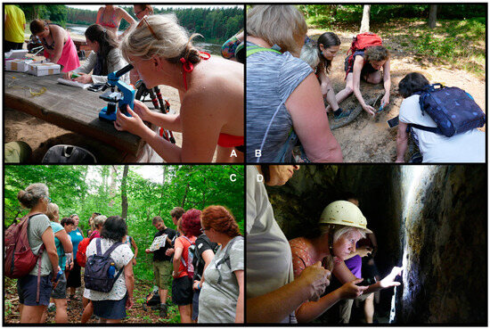
Figure 5.
Photo documentation from the implementation of the described research activities: (A) determination of small animals, (B) using a mobile application to identify plants, (C) explanation of geological inquiry-based activity, (D) determination of rocks in underground spaces.
3.2. Evaluation of Feedback from Participants
The second phase of the research used participants’ follow-up reflections after the above activities had taken place. In this reflection, participants evaluated the individual activity designs, commented on their implementation and other technical issues (which were not the focus of the research), and also commented on how the individual themes interrelated and what conclusions were drawn from this (which was information we subsequently processed). During the reflections, some participants’ statements were recorded, which expressed their feelings about the program that took place. Other analyzed information was then provided by short questionnaires, which the participants voluntarily filled out at the end of the day. We have sorted the responses from the two sources mentioned above by topic, and the most relevant ones are listed below. The number of responses in individual categories is shown in Figure 6, and the interrelationships between the responses are shown in Table 2.
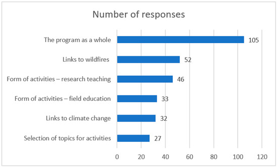
Figure 6.
Number of responses in each category.
Table 2.
Interrelationships between answers—the number of answers in each category that also mentioned another monitored topic.
3.2.1. Form of Activities—Research Teaching
“I really like research tasks in teaching. Although it is more difficult to invent them, their effect is much higher than in traditional frontal teaching. Pupils remember better what they have tried out themselves than what someone has dictated to them”.
“I enjoyed going from one activity to the next and gradually discovering the links between the topics. In this way, we naturally kept gaining more information until the result was a pretty good overview of the interconnections between the topics”.
“The biggest advantage of research-based learning is that the pupils discover the facts themselves and do not feel that someone is imposing their opinion on them. They discover how a phenomenon manifests itself and what it may influence. The results obtained this way are then more respected and not questioned”.
“I am delighted that I was able to learn about different research activities suggested by other participants in this course. I find it challenging to come up with research activities. Because of this, they are not so often included in the classroom”.
“With research activities, it matters a lot how well they are thought out so that they are scientific enough but, on the other hand, fun. I was surprised by how many exciting activities we could come up with in a relatively short time. I will try to use some of them in my teaching”.
3.2.2. Form of Activities—Field Education
“Outdoor education is great, fun and good for your health, but unfortunately, there is little time for it during the school year”.
“Students love field education, but teachers are terrified of what students will do during field education. Fortunately, many of the activities that were on display today can be done in the schoolyard where the students are relatively safe”.
“The field is where dry theory only discussed in class becomes an interesting reality. I try to do several blocks of field education during the year so that the students can relate the information in class to reality”.
“When students learn about nature, they should ideally be in nature. It is a pity that field education is given little space in the Czech curriculum”.
“Although being in the field gives more authenticity to the teaching, due to the limited space for field teaching in the real classroom, various research tasks can be done in the school building or on the surrounding grounds. Rocks can be brought into the classroom, soil experiments can be done in an aquarium, etc. However, only in the field is it possible to see everything around you simultaneously and in context”.
3.2.3. Selection of Topics for Activities
“I personally missed the topic of fires because that is something that has been happening more and more often here lately. The fire last year (2022) was huge, it was talked about a lot in the media, and it is a big threat for the local people as well, because the region is very much dependent on tourism”. Authors’ note: the topic of fires was not included intentionally.
“I found the topic of agriculture a bit redundant because it is clear from previous activities that the conditions are not suitable for agriculture here”.
“Climate is a difficult topic because it is something that does not lend itself very well to one-off research. Yes, I can measure the actual weather in the field, but I cannot record the climate and its change in the field. It can only be seen from the maps we have. But the maps are already a downloaded source, so students may not have confidence in it”.
“Perhaps the topic of tourism deserves more space because it is something that currently has a significant impact on the natural environment and is the main economic activity in the region. Tourism has both positive and negative impacts on the region, and I would probably focus more on this topic in my teaching so that pupils are aware of the connections”.
3.2.4. The Program as a Whole
“I think we have succeeded in creating a set of activities that creates a comprehensive physical-geographical and human-geographical characterization of the area”.
“I like the fact that, on the basis of the individual activities, we can gradually realize how closely interconnected the different components are and, to put it bluntly, that everything is related to everything”.
“Comprehensive geography characteristics are something that I require my students to be able to create in high school (ages 15–19). However, for them, it is mostly a task where they just take in data and don’t think about it. Research assignments are an alternative that gets them much more actively involved in the process”.
“I liked the diversity of the activities—while in geology, we were pounding rocks with a geological hammer, in biota, we were trying to identify plant species using a mobile app”.
3.2.5. Links to Wildfires
“I do not know about others, but when I put together the findings from all the activities together, it seems to me that the national park is an area that is increasingly threatened by fires, so we may experience something similar to last year (2022) more often”.
“I was almost frightened by the results of today’s program. As someone who lives in this area, it means that the wildfire nightmare of last year (2022) is definitely not the last because we are unable to change the local geology and physical geography”.
“One other fact that struck me about the fires is that careless tourists cause the vast majority of them. At a time when we have seen the number of tourists coming here multiply several times over the last ten or fifteen years, that is worrying”.
“From my point of view, the main culprit of the current fire risks is the forestry industry because it has cleared native forests and replaced them with spruce monocultures, which are extremely vulnerable to droughts. When a forest that is supposed to hold water is dry and dead because of a bark beetle calamity, it is probably very vulnerable to fire damage”.
“I would also mention that fires are a natural part of many ecosystems and, in reality, an opportunity to replace non-native tree species with an ecosystem close to nature. The only ones who are bothered by fires are the local people who may have their houses burned down or lose their jobs because not many people want to look at a burn site during their vacation”.
3.2.6. Links to Climate Change
“In my opinion, it was very clever that none of the topics given were climate change because some participants might take it as you trying to impose your opinion on them. That way, after all the activities, one can say to oneself that something is probably changing in the local nature and derive the explanation oneself”.
“I think the research activities are a great way of teaching about climate change. In the school where I teach, there are many pupils from socially disadvantaged families who, for ideological reasons, deny the existence of climate change because it makes things more expensive for them in practice—they have more expensive electricity because of the switch to renewables, they hate electric cars because they are too expensive for them, etc. On the other hand, their perspective may change when they realize that their environment is also threatened by climate change, including their homes and their parents’ jobs”.
“Our region is one of the poorer ones in Czechia, so people are solving their own problems rather than the world’s problems. That is why when you start discussing climate change with someone, they tell you to leave them alone because they don’t care. However, thanks to the fire last year (2022), this topic has also started to be more discussed among people because they are starting to realize that it is not just about melting glaciers or changing sea streams somewhere far away but also about droughts and fires here and now”.
“Climate change is a difficult topic—it can be seen that even here in the group, we do not all have the same opinion as to how much the forest fires in recent years are caused by climate change and how much the increasing number of visitors in the national park and their carelessness or recklessness have an effect on them. It seems to me that today’s program did not try to impose its opinion on anyone, but that we only tried to present certain facts, while their interpretation is up to each of us”.
“I think it is an important message that due to the local geology, this region is more vulnerable to climate change than other regions in Czechia. Therefore, local people should think about how to adapt to these changes and mitigate their adverse consequences”.
4. Discussion
The results presented in the previous chapter capture the most critical elements of the implemented activities and the feedback to them. Although the participants of the summer schools had the opportunity to invent any research activities on the given topics, their key messages did not differ much from each other. The implementation of the activities and the tools used varied depending on the topic (e.g., for the topic “geology”, the activities were very similar for all groups, while for issues such as “forestry” or “tourism”, they were quite different). The success and popularity of individual activities often depended on how much experience the participants had with conducting research activities in the past. Overall, most participants were able to complete the assignment.
If we focus on the results more closely, the first thing that needs to be commented on is the procedure where the participants were first encouraged to identify the key insight in the given topic—i.e., to reduce the entire complex issue to certain information that the other participants would have, thanks to their activity, remember. The participants mainly focused on the specifics of this area, which is why their messages were very similar (Table 1 shows one key insight for each topic, but the others differed from it only in detail). The advantage of this procedure, called generalization in education, is that it can focus the attention of the authors of educational activities on the essential elements and put aside less important details. As proven by various studies [53,54,55], pupils and students remember the content of the course better because they are not overwhelmed by an unnecessarily large amount of details.
The second thing that deserves comment is that the research activities were arranged in order to form a comprehensive geological-geographical characteristic of the territory. However, the main topic, which was the connection between the devastating fire of 2022 and climate change, was not the content of any of the activities, although the participants were able to connect the information shared and implement the knowledge on this topic as well. Thanks to this, they did not feel that this opinion was imposed on them and were able to accept it better. This insight correlates with other research, where older students, in particular, prefer when they can form their own opinions based on working with data or their own analysis [54,55,56]. Such activities nonviolently develop geoethics, an important social role of geosciences aiming to foster a critical examination of the utilization of natural resources, advocate for accurate dissemination of information about natural hazards, encourage the advancement of eco-friendly technologies, and protection of geosites [57,58,59].
The evaluation of the set of research activities in the subsequent reflection or the evaluation questionnaires was very positive. However, it is necessary to perceive that the participants in the summer schools were voluntary. They knew what their content would be, so they were people who were interested in these educational methods and wanted to improve them. What we consider necessary, however, is that the participants described this education model as very suitable for situations where the given topic is highly politicized in Czechia. Authors suppose that climate change skepticism is frequent, particularly in the peripheral border regions, expecting causal relations of the attitudes towards climatic change to education, unemployment, election results, and general discontent with mainstream narratives. It can cause the class collective to hold radically opposing views. Climate change is such a topic, and in the relatively poorer Czech borderland with a troublesome history [18], there are a large number of people who believe various fake news and deny its existence. Instead of thinking about climate change and the fight against it, they live their daily lives. The presented set of activities does not lead to a single correct interpretation (in the end, both the participants themselves and expert sources indicate that not only climate change but also inappropriate forestry practices [19] and damage to nature by mass tourism [19,60] are the causes of the less than ideal state of the national park and its geosites. Everyone can determine the degree of influence of climate change on the fire.
5. Conclusions
The summer school participants conducted research activities on various topics, and the success of these activities often depended on the participants’ prior experience with research-based education. The participants were encouraged to identify the key insight in their topic, focusing on the specifics of the area. This method, known as generalization, helps focus on essential elements and ignore less important details, improving content retention and comprehensibility for pupils. The research activities were designed to provide a geological-geographical characteristic of the territory, with the main topic being the connection between the 2022 fire and climate change. The participants were able to connect the information shared and implement knowledge on this topic. The evaluation of the research activities was positive, with participants describing the education model as suitable for politicized topics in Czechia, particularly in peripheral regions. The model allows for multiple interpretations, accommodating differing views on topics such as climate change. However, it is important to note that the participants were volunteers who were interested in these educational methods. The activities do not lead to a single correct interpretation, allowing for a more nuanced understanding of complex issues.
In conclusion, it must be said that although the topics of climate change and fire were not selected as categories for the teaching activities, these topics emerged spontaneously among the participants in the study as key themes for understanding the territory. The authors evaluate it very positively, as this was their initial intention to link the wildfire mainly to climate change. The model teaching at these summer schools used the environment of sandstone rocks in the BSNP and its surroundings, including several attractive geosites. Nevertheless, similar activities can be organized practically anywhere. Inquiry-based learning community portals have recently been developing in Czechia. At the same time, the participants of our summer schools were also inspired by some well-known projects when creating their own activities [61,62,63]. Therefore, we can only wish that by involving them more often in teaching, they would activate their pupils and students, not only forcing them to accept the facts but letting them form their own opinion on the problem based on the available facts and data, as in the example presented by us.
Author Contributions
Conceptualization, A.B. and E.D.; methodology, E.D.; validation, A.B. and E.D.; formal analysis, A.B.; investigation, E.D.; resources, A.B.; data curation, E.D.; writing—original draft preparation, A.B. and E.D.; writing—review and editing, A.B. and E.D.; visualization, E.D.; supervision, A.B. All authors have read and agreed to the published version of the manuscript.
Funding
This research received no external funding.
Institutional Review Board Statement
Authors declare that the study was conducted in accordance with the ethical rules that are generally accepted for questionnaire surveys in humanities research.
Informed Consent Statement
Informed consent was obtained from all subjects involved in the study.
Data Availability Statement
Data are available upon reasonable request from authors.
Conflicts of Interest
Authors declare no conflict of interest.
References
- Gordon, J.E.; Wignall, R.M.L.; Brazier, V.; Crofts, R.; Tormey, D. Planning for Climate Change Impacts on Geoheritage Interests in Protected and Conserved Areas. Geoheritage 2002, 14, 126. [Google Scholar] [CrossRef]
- Gordon, J.E. Climate Change and Geotourism: Impacts, Challenges, and Opportunities. Tour. Hosp. 2023, 4, 514–538. [Google Scholar] [CrossRef]
- Howard, A.J. Managing global heritage in the face of future climate change: The importance of understanding geological and geomorphological processes and hazards. Int. J. Herit. Stud. 2013, 197, 632–658. [Google Scholar] [CrossRef]
- Selmi, L.; Canesin, T.S.; Gauci, R.; Pereira, P.; Coratza, P. Degradation Risk Assessment: Understanding the Impacts of Climate Change on Geoheritage. Sustainability 2022, 14, 4262. [Google Scholar] [CrossRef]
- Bollati, I.M.; Rossi, D.; Viani, C. Outdoor River Activities: Relations with Geological Background and Extreme Events in the Perspective of Geoeducation. Geosciences 2023, 13, 122. [Google Scholar] [CrossRef]
- Catana, M.M.; Brilha, J.B. The Role of UNESCO Global Geoparks in Promoting Geosciences Education for Sustainability. Geoheritage 2020, 12, 1. [Google Scholar] [CrossRef]
- Giardino, M.; Justice, S.; Olsbo, R.; Balzarini, P.; Magagna, A.; Viani, C.; Selvaggio, I.; Kiuttu, M.; Kauhanen, J.; Laukkanen, M.; et al. ERASMUS+ Strategic Partnerships between UNESCO Global Geoparks, Schools, and Research Institutions: A Window of Opportunity for Geoheritage Enhancement and Geoscience Education. Heritage 2022, 5, 677–701. [Google Scholar] [CrossRef]
- Vegas, J.; Baeza, E.; Cabrera, A.; Diez-Herrero, A.; Ferrer, N.; Galindo, I.; Garrote, J.; Gonzalez-Laguna, R.; Herrera, R.; Lario, J.; et al. Impacts, vulnerability and resilience of Geoheritage to Climate Change in the four Canary Islands National Parks (Spain). In Proceedings of the 10th International Conference on Geomorphology, Coimbra, Portugal, 12–16 September 2022. ICG2022-194. [Google Scholar]
- Kołodziejczyk, K. Tourist management in national parks in the Czech-German borderland: Bohemian ‘Switzerland‘ and Saxon ‘Switzerland’. J. Mt. Sci. 2020, 17, 2853–2879. [Google Scholar] [CrossRef]
- Štěbetáková, M.; Hruška, V.; Raška, P. Bohemian Switzerland: Long-Term Spatiotemporal Transformations of Tourism Facilities in Rural Peripheries Between the Regulations and Access for All. Eur. Countrys. 2022, 14, 328–345. [Google Scholar] [CrossRef]
- Vaishar, A.; Dvořák, P.; Nosková, H.; Zapletalová, J. Present consequences of the post-war migration in the Czech borderland for regional development. Quaest. Geogr. 2017, 36, 5–15. [Google Scholar] [CrossRef][Green Version]
- Krkoška Lorencová, E.; Loučková, B.; Vačkářů, D. Perception of Climate Change Risk and Adaptation in the Czech Republic. Climate 2019, 7, 61. [Google Scholar] [CrossRef]
- Ocelík, P. Climate change scepticism in front-page Czech newspaper coverage: A one man show. In Handbook of Anti-Environmentalism; Tindall, D., Stoddart, M.C.J., Dunlap, R.E., Eds.; Edward Elgar Publishing: Cheltenham, UK, 2022; pp. 84–106. [Google Scholar] [CrossRef]
- Meitner, J.; Balek, J.; Bláhová, M.; Semerádová, D.; Hlavinka, P.; Lukas, V.; Jurečka, F.; Žalud, Z.; Klem, K.; Anderson, M.C.; et al. Estimating Drought-Induced Crop Yield Losses at the Cadastral Area Level in the Czech Republic. Agronomy 2023, 13, 1669. [Google Scholar] [CrossRef]
- Lohmander, P.; Mohammadi, Z.; Kašpar, J.; Tahri, M.; Berčák, R.; Holuša, J.; Marušák, R. Future forest fires as functions of climate change and attack time for central Bohemian region, Czech Republic. Ann. For. Res. 2022, 65, 17–30. [Google Scholar] [CrossRef]
- San-Miguel-Ayanz, J.; Durrant, T.; Boca, R.; Maianti, P.; Liberta’, G.; Artes Vivancos, T.; Jacome Felix Oom, D.; Branco, A.; de Rigo, D.; Ferrari, D.; et al. Forest Fires in Europe, Middle East and North Africa 2021; Publications Office of the European Union: Luxembourg, Luxembourg, 2022. [Google Scholar]
- Jaagus, J.; Aasa, A.; Aniskevich, S.; Boincean, B.; Bojariu, R.; Briede, A.; Danilovich, I.; Castro, F.D.; Dumitrescu, A.; Labuda, M.; et al. Long-term changes in drought indices in eastern and central Europe. Int. J. Climatol. 2022, 42, 225–249. [Google Scholar] [CrossRef]
- Korčák, M.; Netrdová, P. Historická hranice Sudet a současná sociálně-prostorová diferenciace Česka: Kvantitativní pohled na dlouhodobý dopad institucionálních změn (The historical border of the Sudetenland and the current socio-spatial differentiation of Czechia: A quantitative view of the long-term impact of institutional changes). Geografie 2022, 127, 365–390. [Google Scholar] [CrossRef]
- Hruška, J.; Balek, J.; Beranová, J.; Bláhová, M.; Bobek, P.; Ciencala, E.; Homolová, L.; Kudláčková, L.; Krajhanzl, J.; Možný, M.; et al. Jaké Faktory Ovlivnily Vznik Požáru v NP České Švýcarsko? (What Factors Influenced the Origin of the Fire in Bohemian Switzerland NP? Scientific Study for the Ministry of Environment of the Czech Republic. 2022. Available online: https://www.mzp.cz/C1257458002F0DC7/cz/news_20220106-Vedci-zmapovali-pozar-v-Ceskem-Svycarsku-Majitele-lesu-se-z-nej-musi-ponaucit-Pro-prirodu-ale-znamena-probihajici-obnova-velkou-sanci/$FILE/Studie_faktoru_pozaru_Narodni_park_Ceske_Svycarsko.pdf (accessed on 3 September 2023).
- Milanović, S.; Trailović, Z.; Milanović, S.D.; Hochbichler, E.; Kirisits, T.; Immitzer, M.; Čermák, P.; Pokorný, R.; Jankovský, L.; Jaafari, A. Country-Level Modeling of Forest Fires in Austria and the Czech Republic: Insights from Open-Source Data. Sustainability 2023, 15, 5269. [Google Scholar] [CrossRef]
- Cílek, V. Saxon-Bohemian Switzerland: Sandstone Rock Cities and Fascination in a Romantic Landscape. In Geomorphological Landscapes of the World; Migoń, P., Ed.; Springer: Berlin/Heidelberg, Germany, 2010; pp. 201–209. [Google Scholar]
- Zvelebil, J.; Vařilová, Z.; Paluš, M. Tools for Rock Fall Risk Integrated Management in Sandstone Landscape of the Bohemian Switzerland National Park, Czech Republic (M121). In Landslides: Risk Analysis and Sustainable Disaster Management; Sassa, K., Fukuoka, H., Wang, F., Wang, G., Eds.; Springer: Berlin/Heidelberg, Germany, 2005; pp. 119–126. [Google Scholar] [CrossRef]
- Bruthans, J.; Soukup, J.; Vaculikova, J.; Filippi, M.; Schweigstillova, J.; Mayo, A.L.; Masin, D.; Kletetschka, G.; Rihosek, J. Sandstone landforms shaped by negative feedback between stress and erosion. Nat. Geosci. 2014, 7, 597–601. [Google Scholar] [CrossRef]
- Vařilová, Z.; Navrátil, T.; Dobešová, I. Recent Atmospheric Deposition and its Effects on Sandstone Cliffs in Bohemian Switzerland National Park, Czech Republic. Water Air Soil Pollut. 2011, 220, 117–130. [Google Scholar] [CrossRef]
- Waldron, J.W.F.; Locock, J.; Pujadas-Botey, A. Building an Outdoor Classroom for Field Geology: The Geoscience Garden. J. Geosci. Educ. 2016, 64, 215–230. [Google Scholar] [CrossRef]
- Kent, M.; Gilbertson, D.; Hunt, C.O. Fieldwork in geography teaching: A critical review of the literature and approaches. J. Geogr. High. Educ. 1997, 21, 313–332. [Google Scholar] [CrossRef]
- Steward, K.C.; Bhattacharya, D.; Chandler, M.; Forbes, C.T. Secondary science teachers’ implementation of a curricular intervention when teaching with global climate models. J. Geosci. Educ. 2022, 70, 474–489. [Google Scholar] [CrossRef]
- Meadows, M. Geography Education for Sustainable Development. Geogr. Sustain. 2020, 1, 88–92. [Google Scholar] [CrossRef]
- Mönter, L.; Otto, K. The concept of disasters in Geography Education. J. Geogr. High. Educ. 2018, 42, 205–219. [Google Scholar] [CrossRef]
- Quitt, E. Klimatické Oblasti Československa (Climate Regions of Czechoslovakia); Academia: Prague, Czech Republic, 1971. [Google Scholar]
- Patacca, M.; Lindner, M.; Lucas-Borja, M.E.; Cordonnier, T.; Fidej, G.; Gardiner, B.; Hauf, Y.; Jasinevičius, G.; Labonne, S.; Linkevičius, E.; et al. Significant increase in natural disturbance impacts on European forests since 1950. Glob. Chang. Biol. 2023, 29, 1359–1376. [Google Scholar] [CrossRef] [PubMed]
- Možný, M.; Trnka, M.; Brázdil, R. Climate change driven changes of vegetation fires in the Czech Republic. Theor. Appl. Climatol. 2021, 143, 691–699. [Google Scholar] [CrossRef]
- Trnka, M.; Balek, J.; Možný, M.; Cienciala, E.; Čermák, P.; Semerádová, D.; Jurečka, F.; Hlavinka, P.; Štěpánek, P.; Farda, A.; et al. Observed and expected changes in wildfire-conducive weather and fire events in peri-urban zones and key nature reserves of the Czech Republic. Clim. Res. 2020, 82, 33–54. [Google Scholar] [CrossRef]
- Moravec, V.; Markonis, Y.; Rakovec, O.; Svoboda, M.; Trnka, M.; Kumar, R.; Hanel, M. Europe under multi-year droughts: How severe was the 2014-2018 drought period? Environ. Res. Lett. 2021, 16, 034062. [Google Scholar] [CrossRef]
- Změna Klimatu v ČR (Climate Change in Czechia); Czech Hydrometeorological Institute: Prague, Czech Republic, 2023; Available online: https://www.chmi.cz/files/portal/docs/meteo/ok/klimazmena/files/cc_chap10.pdf (accessed on 1 September 2023).
- Kocinová, M.; Nedělníková, H. Statistical Yearbook 2021 of the Fire Rescue Service of the Czech Republic; Fire Rescue Service of the Czech Republic: Prague, Czech Republic, 2021. [Google Scholar]
- Blahová, M.; Frélich, Z.; Karkoszková, Z.; Misiaček, R.; Trojáčková, Z. Studie Potřeb Obcí Regionu NP České Švýcarsko v Oblasti Ochrany ŽP a Udržitelného Rozvoje Obcí (Study of the Needs of Municipalities in the Bohemian Switzerland NP Region in the Area of Environmental Protection and Sustainable Development of Municipalities); RADDIT Consulting: Krmelín, Czech Republic, 2020; Available online: https://www.ceskesvycarsko.cz/sites/default/files/inline-files/Studie%20pot%C5%99eb_obc%C3%AD_NP%C4%8C%C5%A0_pro_SF%C5%BDP-formal_fin_0.pdf (accessed on 4 September 2023).
- Paluš, M.; Novotná, D.; Zvelebil, J. Fractal rock slope dynamics anticipating collapse. Phys. Rev. E 2004, 70, 36212. [Google Scholar] [CrossRef]
- Buček, A.; Lacina, J. Geobiocenologie II: Geobiocenologická Typologie Krajiny České Republiky (Geobiocenology II: Geobiocenological Typology of the Landscape of the Czech Republic); Mendelova Zemědělská a Lesnická Univerzita: Brno, Czech Republic, 1999. [Google Scholar]
- Patzelt, Z. Mimořádná Událost—Požár v Národním Parku České Švýcarsko (Extraordinary Event—Fire in the Bohemian Switzerland National Park). Ochr. Přírody 2022, 4, 45–48. [Google Scholar]
- Biró, A.; Hlavička, V.; Lublóy, E. Effect of fire-related temperatures on natural stones. Constr. Build. Mater. 2019, 212, 92–101. [Google Scholar] [CrossRef]
- Svobodová, H.; Mísařová, D.; Durna, R.; Hofmann, E. Geography Outdoor Education from the Perspective of Czech Teachers, Pupils and Parents. J. Geogr. 2020, 119, 32–41. [Google Scholar] [CrossRef]
- Svobodová, H.; Mísařová, D.; Durna, R.; Češková, T.; Hofmann, E. Koncepce Terénní Výuky pro Základní Školy (Conception of Fieldwork for Basic Schools); Masarykova Univerzita: Brno, Czech Republic, 2019. [Google Scholar]
- Krathwohl, D.R. A Revision of Bloom’s Taxonomy: An Overview. Theory Into Pract. 2002, 41, 212–218. [Google Scholar] [CrossRef]
- Rámcový Vzdělávací Program pro Základní Školy (Framework Educational Program for Basic Education); MŠMT: Praha, Czech Republic, 2023; Available online: https://www.edu.cz/rvp-ramcove-vzdelavaci-programy/ramcovy-vzdelavacici-program-pro-zakladni-vzdelavani-rvp-zv (accessed on 28 August 2023).
- Rámcový Vzdělávací Program pro Gymnázia (Framework Educational Program for Grammar Schools); MŠMT: Praha, Czech Republic, 2023; Available online: https://www.edu.cz/rvp-ramcove-vzdelavaci-programy/ramcove-vzdelavaci-programy-pro-gymnazia-rvp-g (accessed on 28 August 2023).
- The 2016 International Charter on Geographical Education; International Geographical Union: Amsterdam, The Netherlands, 2016; Available online: https://www.igu-cge.org/wp-content/uploads/2019/03/IGU_2016_eng_ver25Feb2019.pdf (accessed on 29 August 2023).
- Gruenewald, D.A. Foundations of place: A multidisciplinary framework for place-conscious education. Am. Educ. Res. J. 2003, 40, 619–654. [Google Scholar] [CrossRef]
- Triantaphyllou, M.V.; Firkasis, N.; Tsourou, T.; Vassilakis, E.; Spyrou, E.; Koukousioura, O.; Oikonomou, A.; Skentos, A. “Geo-Archaeo-Routes” on the Island of Lemnos: The “Nalture” Experience as a Holistic Geotouristic Approach within the Geoethical Perspective. Geosciences 2023, 13, 143. [Google Scholar] [CrossRef]
- Schild, R. Environmental citizenship: What can political theory contribute to environmental education practice? J. Environ. Educ. 2016, 47, 19–34. [Google Scholar] [CrossRef]
- Israel, A.L. Putting geography education into place: What geography educators can learn from Place-Based Education, and vice versa. J. Geogr. 2012, 111, 76–81. [Google Scholar] [CrossRef]
- Ardoin, N.M.; Schuh, J.S.; Gould, R.K. Exploring the dimensions of place: A confirmatory factor analysis of data from three ecoregional sites. Environ. Educ. Res. 2012, 18, 583–607. [Google Scholar] [CrossRef]
- Drápela, E. Assessing the Educational Potential of Geosites: Introducing a Method Using Inquiry-Based Learning. Resources 2022, 11, 101. [Google Scholar] [CrossRef]
- Briggs, M. Qualitative Assessment of Inquiry-Based Teaching Methods. J. Chem. Educ. 2011, 88, 1034–1040. [Google Scholar] [CrossRef]
- Karamustafaogu, S.; Havuz, A.C. Inquiry Based Learning and Its Effectiveness. Int. J. Assesment Tools Educ. 2016, 3, 40–54. [Google Scholar]
- Drápela, E. Using a Geotrail for Teaching Geography: An Example of the Virtual Educational Trail “The Story of Liberec Granite”. Land 2023, 12, 828. [Google Scholar] [CrossRef]
- Peppoloni, S.; Di Capua, G. Geoethics and geological culture: Awareness, responsibility and challenges. Ann. Geophys. 2012, 55, 335–341. [Google Scholar] [CrossRef]
- Peppoloni, S.; Di Capua, G. The Meaning of Geoethics. In Geoethics: Ethical Challenges and Case Studies in Earth Sciences; Wyss, M., Peppoloni, S., Eds.; Elsevier: Amsterdam, The Netherlands, 2015; pp. 3–14. [Google Scholar]
- Peppoloni, S.; Di Capua, G. The significance of geotourism through the lens of geoethics. In Proceedings of the EGU General Assembly 2022, Vienna, Austria, 23–28 May 2022; EGU: Vienna, Austria, 1756. [Google Scholar]
- Drápela, E. Prevention of damage to sandstone rocks in protected areas of nature in northern Bohemia. AIMS Geosci. 2021, 7, 56–73. [Google Scholar] [CrossRef]
- Učíme Badatelsky (We Teach by Research). Available online: https://www.ucimebadatelsky.cz/ (accessed on 28 August 2023).
- Badatelé (Researchers). Available online: https://badatele.cz/ (accessed on 28 August 2023).
- Program GLOBE (GLOBE Program). Available online: https://globe-czech.cz/cz (accessed on 28 August 2023).


Disclaimer/Publisher’s Note: The statements, opinions and data contained in all publications are solely those of the individual author(s) and contributor(s) and not of MDPI and/or the editor(s). MDPI and/or the editor(s) disclaim responsibility for any injury to people or property resulting from any ideas, methods, instructions or products referred to in the content. |
© 2023 by the authors. Licensee MDPI, Basel, Switzerland. This article is an open access article distributed under the terms and conditions of the Creative Commons Attribution (CC BY) license (https://creativecommons.org/licenses/by/4.0/).