Article

A Middle Permian Oasis for Vertebrate and Invertebrate Life in a High-Energy Fluvial Palaeoecosystem of Southern Gondwana (Karoo, Republic of South Africa)

by
Ausonio Ronchi
1,*,
Lorenzo Marchetti
2,
Hendrik Klein
3 and
Gideon Hendrik Groenewald
4
1
Dipartimento di Scienze della Terra e dell’Ambiente, Università degli Studi di Pavia, Via Ferrata 1, 27100 Pavia, Italy
2
Museum für Naturkunde Berlin, Leibniz-Institut für Evolutions- und Biodiversitätsforschung, Invalidenstrasse 43, 10115 Berlin, Germany
3
Saurierwelt Paläontologisches Museum, Alte Richt 7, 92318 Neumarkt, Germany
4
Evolutionary Studies Institute, Wits University, Private Bag 3, Johannesburg 2050, South Africa
*
Author to whom correspondence should be addressed.
Geosciences 2023, 13(11), 325; https://doi.org/10.3390/geosciences13110325
Submission received: 2 September 2023 / Revised: 21 October 2023 / Accepted: 23 October 2023 / Published: 25 October 2023
(This article belongs to the Section Sedimentology, Stratigraphy and Palaeontology)

Abstract

:
The Gansfontein palaeosurface (Fraserburg, Karoo, South Africa), which is correlated with the stratigraphic lowermost part of the continental Middle–Upper Permian Teekloof Formation, is revisited. This treasure trove of peculiar and exquisitely preserved sedimentary structures and invertebrate and vertebrate traces serves as a document of a set of fluvial paleoenvironments ranging from small ponds to marginal lacustrine and muddy riverine outer banks. It represents an isolated and relatively small “oasis” within the dominating sedimentary environments of the Teekloof Formation characterized by fine and medium-grained siliciclastics related to repeated higher-energy flooding events. The vertebrate traces include abundant therapsid trackways and, locally, tetrapod swimming traces. Tetrapod footprints show a very variable preservation in different areas of the palaeosurface, and it also changed based on the time of impression. Fish trails (Undichna) are relatively common. The invertebrate ichnofauna is comprised of abundant arthropod traces and horizontal burrows; however, the palaeosurface was not intersected by intense bioturbation. The occurrence of this scenario of abundant life reflects complex interaction among different tracemakers with the substrate and is evidence of a relatively quiet palaeoenvironment, which was suddenly submerged and sealed during a flooding event. Sedimentological and ichnological insights from such a palaeosurface, therefore, opens a rare window into Middle Permian ecosystems in southernmost Gondwana.

1. Introduction

Studies coupling ichnology and sedimentology of the Middle–Upper Permian continental deposits from Southern Gondwana, and particularly South Africa, are relatively rare [1,2,3,4,5]. Among the most recent papers is the first description of a Cochlichnus-dominated ichnofossil site from the Mid- to Upper Permian Middleton Formation in Eastern Cape (Karoo Supergroup) [6] and a comprehensive review of Mid- to Late Permian tetrapod footprints from South Africa [7].
In 1968, after heavy rains, some vertebrate trace fossils were originally discovered by a landowner between the towns of Fraserburg and Williston. The trace fossils were impressed on a relatively wide surface called the Gansfontein palaeosurface [8]. Ref. [3] was the first to formally study the site, and the author of [4] provided a more detailed sedimentological and ichnological analysis, also comprising other palaeosurface types from the same stratigraphic interval. According to the author of [4], palaeosurfaces represent ancient depositional landforms that are preserved with their original topography and intact surface sculpture.
In the present work, we revisit the Gansfontein palaeosurface (Figure 1A,B,D), making observations from both sedimentological and ichnological viewpoints. A very rich ichnological fossil content is exposed, displaying a combination of both vertebrate (walking and swimming traces) and invertebrate (walking and resting traces, grazing trails, and horizontal burrows) trace fossils. The preserved ecosystem represents a kind of “oasis” within a mostly high-energy fluvial palaeoenvironment. Numerous excellently preserved primary sedimentary structures help to unravel facies and sub-facies of this rare setting in the continental Middle Permian of southern Gondwana, where this biota existed and different faunal elements interacted.

2. Materials and Methods

We surveyed all of the area to identify the best representative stratigraphic section of the palaeosurface. The selected section was then measured in great detail and described for its lithostratigraphy and sedimentology through the exposures of interbedded sandstones, siltstones, and mudstones. Lithologies, color, and every single sedimentary structure were reported and described. Vertebrate and invertebrate traces have been studied first-hand and documented with digital photographs (Canon EOS 70D) in oblique light. Invertebrate traces have been evaluated in terms of invertebrate ichnofacies and invertebrate ichnodisparity, e.g., [9,10].
Three-dimensional models of the tetrapod footprints were obtained through digital photogrammetry with the software Agisoft Photoscan Professional® (v.1.4.0). Contour lines and color depth maps were obtained by employing the software Cloud Compare® (v.2.8 beta) and Paraview® (v.4.1.0). Vertebrate footprints have been evaluated in terms of morphological preservation sensu [11] in relation to the substrate conditions and associated sedimentary structures. Tetrapod trackways from the Gansfontein site were indicated with the acronym GF-TR, as in [7]. Institutional abbreviations: SAM = Iziko South African Museum, Cape Town, South Africa.

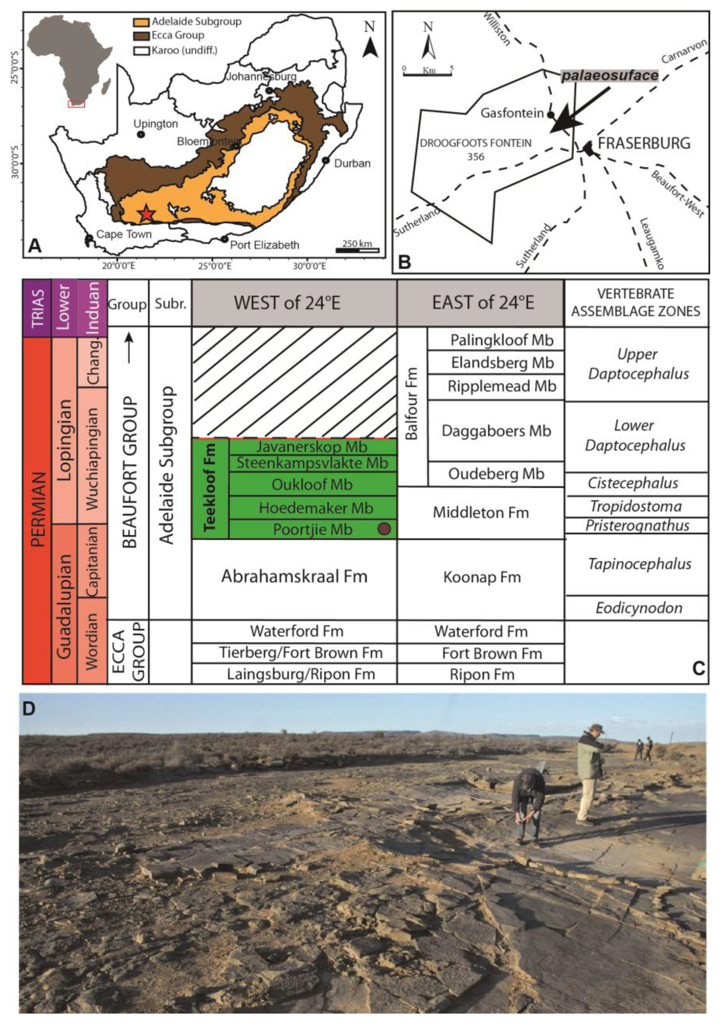
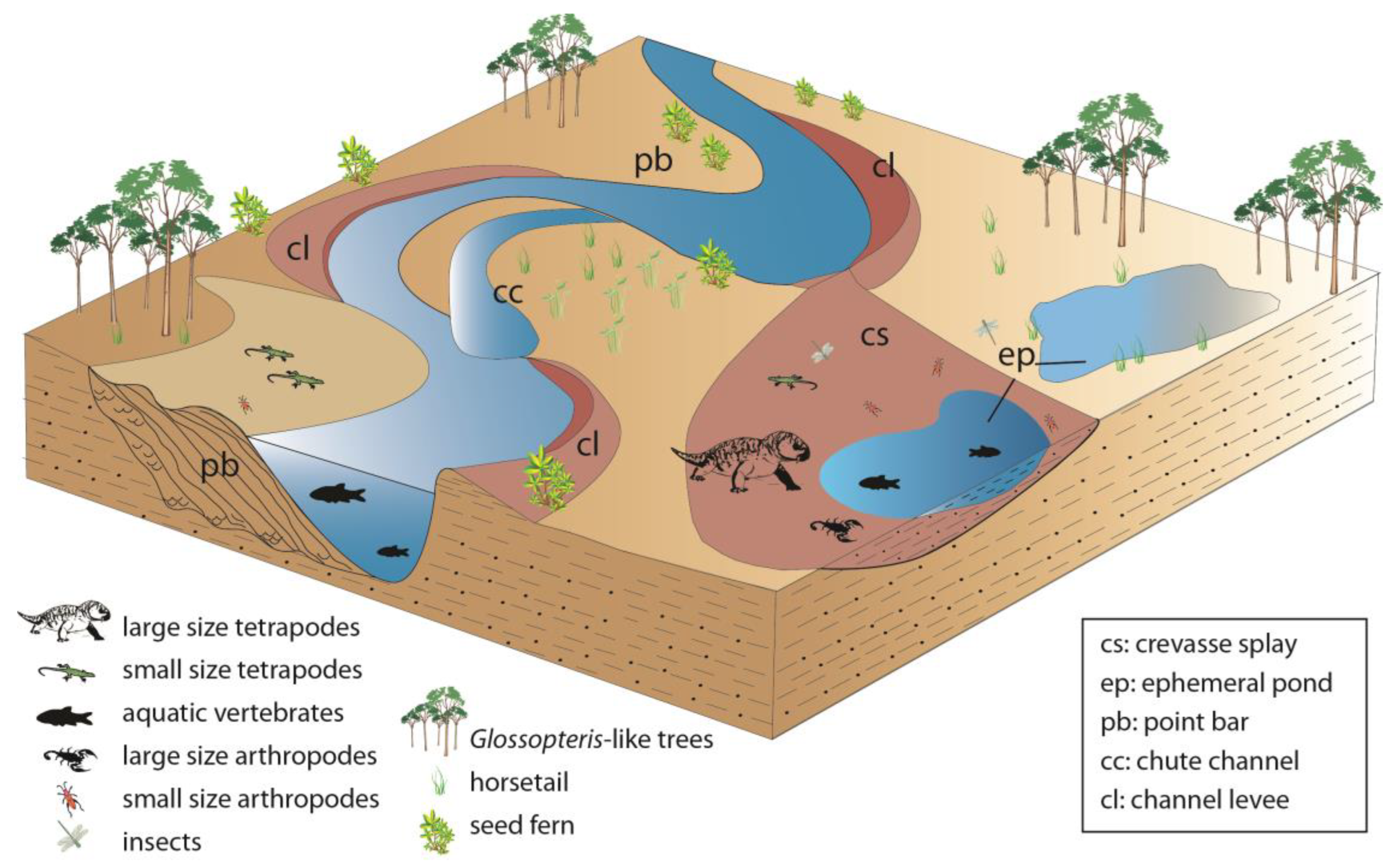
3. Geological Setting

The Middle Permian (upper Wordian) to lower Middle Triassic (Anisian) Beaufort Group (Figure 1C) is a continental succession dominated by mudstones and sandstones organized in characteristic cyclical fining-upward successions. This group is subdivided into two major units: the Permian Adelaide and Triassic Tarkastad subgroups, which are separated by a regionally mappable contact marked, among others, by a higher abundance of sandstone and red-colored mudstones in the latter unit [12,13]. Throughout the basin, the Beaufort Group conformably and diachronously overlies the Ecca Group and is separated from the overlying Stormberg Group by a major unconformity, which is the largest single stratigraphic gap (up to ~12 Ma) in the Karoo Supergroup. Age estimation of the Beaufort Group is mainly based on pollen, flora, and vertebrate assemblages, and it is believed to be one of the most complete terrestrial successions up to the Permian–Triassic boundary, e.g., [14,15]. Radiometric dating has been applied throughout the Adelaide Subgroup [16,17,18,19,20,21,22]. The stratigraphically meaningful radiometric ages were used to provide absolute dates for the tetrapod assemblage zones (AZ), which are widely employed for correlation within the Beaufort Group, e.g., [7,21,22].
The Beaufort Group sediments have been mainly interpreted as deposits of high sinuosity meandering rivers, e.g., [23,24,25] and less commonly as braided fluvial or lacustrine/delta settings [26]. Using an integrated approach based on vertebrate fossil taphonomy, ichnology, and sedimentology, Smith [4,24,25,27] was the first author to record a detailed account of the formations in the Beaufort Group and reconstruct the finer details of the fluvial habitats in the Permian and earliest Triassic. The Adelaide Subgroup (Middle Permian to earliest Triassic, Figure 1A), about 1000 m-thick, consists of blue-grey to green-grey mudstones, siltstones, and moderate to well-sorted, very fine to medium-grained lithofeldspathic sandstone beds with fining-upward cycles interpreted as overbank and channel deposits of mixed-load meandering rivers [23,24,28]. It is subdivided into the Abrahamskraal and Teekloof Formations (corresponding to Middleton and Balfour (pars) formations, east of 24° E) [29,30]. In the N and NE main Karoo Basin, the Abrahamskraal and Teekloof Formations are equivalents of the Balfour and Emakwezini Formations [30,31].
In particular, the Abrahamskraal Formation can be distinguished from the underlying arenaceous deltaic sediments of the Waterford Formation (top of the Ecca Group) by the first appearance of red/purple mudstones considered to represent the first subaerial fluvial deposition and from the overlying Teekloof Formation based on the sandstone percentage, the presence of chert beds, and the abundance of purple mudstone [32]. The Abrahamskraal Formation is well developed in the southern and southwestern parts of the main Karoo Basin and consists of predominantly grey, bluish to greenish-grey, and olive-green mudstone and siltstone with subordinate mottled, light grey, yellow-brown, greyish orange to greenish grey sandstone. Sandstones (~20–30%) are very fine- to medium-grained, arkosic, mostly massive, and rarely cross-bedded. Upward-fining cycles occur, as do slickensides, rare carbonate nodules, and relatively complete plant fossils [33,34]. The mudstones, which are interpreted as overbank deposits, include incipient calcareous palaeosols, indicating warm to hot semi-arid climatic conditions with strongly seasonal rainfall [35]. The fluvial system was mostly comprised of meandering, locally braided rivers with extensive and vegetated, moist floodplains. The Abrahamskraal Formation was subdivided into six members, named from the base: Combrinkskraal, Leeuvlei, Koornplaats, Wilgerbos, Moordenaars, and Karelskraal [36,37,38]. Later on, ref. [39] changed the name of Wilgerbos Member to Swaerskraal Member and added a seventh one in the lower half of the formation, the Grootfontein Member.
The middle–late Guadalupian age (upper Wordian to upper Capitanian) of the Abrahamskraal Formation was recently confirmed by radiometric and magnetostratigraphic studies [18,22]. According to the former authors, the presence of both normal and reversed polarity zones indicate deposition after the end of the Kiaman Superchron, the top of which is located at 269 Ma by the U–Pb zircon ages of ca. 264–268 Ma. New high-resolution U-Pb zircon ages (CA-ID-TIMS) helped in better constraining the upper two-thirds of the Abrahamskraal Formation [22]. The Abrahamskraal Formation has yielded diverse tetrapod fossils which belong to the Tapinocephalus Assemblage Zone [22,39]. The fauna comprises mostly therapsids (Dinocephalia, Dicynodontia, Therocephalia, Gorgonopsia, Biarmosuchia, basal Anomodontia) with less common reptiles (pareiasaurs and Eunotosaurus), rhinesuchid temnospondyls, and rare fish [32,37,38,40,41,42,43]. Fossil plants are also present in silicified wood fragments, stems, and leaves, some of which are preserved in a growing position [34,44].
The Abrahamskraal Fm is overlain by the mudstone-dominated Teekloof Formation, which is subdivided into the Poortjie, Hoedemaker, Oukloof, Steenkampsvlakte, and Javanerskop members, e.g., [28,45]. The units comprise an overall upward-fining megacycle showing a gradual gradient decrease of the regional palaeoslope. Mudstones are grey, blue-grey, and green-grey-colored with a few hallmark red- and maroon-colored units. Within the fines are subordinate light grey to grey, fine- to very-fine-grained, and thin (average ~1 m thick) sandstone bodies (litharenites), which are lenticular in shape. A fluvio-lacustrine palaeoenvironment is assigned to this formation. Fluvial style changes from bottom to top: short-lived, low to more permanent, high-sinuosity rivers [28].
A radiometric date from the lowermost Poortje Member provides a CA-ID-TIMS date of 260.259 ± 0.081 Ma, the latest Guadalupian [21]; the base of Poortjie is at 260.16 + 0.10/−0.15 Ma [22]. This is immediately below the Tapinocephalus– Endothiodon AZ transition in the basal part of the same member, which defines the end-Guadalupian extinction event [21,46,47,48].
Different interpretations were carried out to explain the multiple fining-upwards cycles characterizing the mostly fine-grained Abrahamskraal Formation and the overlying Teekloof Formation, even ascribing them to astronomically forced cycles [49]. Most authors agree in considering this sedimentation to be typically fluvial [32,50]. These latter authors ascribed the Abrahamskraal Formation facies associations as related to dominantly high-sinuosity channels and the Teekloof Formation facies as pertaining to floodplain deposits. In the Beaufort West area, ref. [51] identifies different flat-lying, coastal alluvial plains and their deltaic extension facies models in the Abrahamskraal Formation. Since 1977, no subsequent research has confirmed marginal marine environments.
Ref. [52] illustrated the sedimentary structures on some laterally persistent sandy interbeds, commonly interspaced throughout the argillaceous sequences of the Adelaide Subgroup (just below the “Poortjie Sandstone”), and related them to fluctuating hydrodynamic conditions in flood plain deposits. According to the author of [52], the sedimentation of these sandstones took place in a fluvial environment during ephemeral floods along the lower reaches of an arid flat. The author of [53] specified that this environment represented an interior drainage system characterized by a continuously shifting, ephemeral fluvio-lacustrine setting and subdivided the facies associations in fine-to-medium-grained sandstone channel deposits and mudstone, siltstone, and sandstone interchannel deposits. This twofold subdivision of the strata shows fining-upward cyclic sequences with scoured surfaces. On the other hand, the author of [50] subdivided the Abrahamskraal Formation into a lower part, which consists of low-sinuosity channel deposits, and an upper part with high-sinuosity channel deposits.

4. The Gansfontein Palaeosurface

The outcrop is located between the towns of Fraserburg and Williston and can be reached by turning left from Road 353 onto a tarred road to Williston and driving 2.5 km to a gate and track on the left-hand side of the road (Figure 1B). The site is currently protected, and guided tours are arranged by the Fraserburg Museum.
In the area NW of Fraserburg, the so-called Gansfontein palaeosurface (GPS coordinates 31°54′5.40″ S, 21°28′54.60″ E) is a unique site that is very rich in sedimentary structures and invertebrate and vertebrate traces (Figure 1D). The palaeosurface, exposed in a stream bed at the outlet of a dam (about 1.5 km south of the Gansfontein homestead), is about 25 m wide by 60 m long and is preserved within olive-green siltstones and sandstones. Such exceptionally preserved palaeosurfaces are rarely found in the Lower Beaufort. For this reason, the Geological Society of South Africa (GSSA) recognizes this site as a geoheritage locality [8,54].
The palaeosurface was interpreted by [3] as a distal floodplain setting. Later, it was interpreted as either a proximal crevasse splay setting or a proximal floodplain depositional environment at the base of the meanderbelt slope and between prograding crevasse splay lobes [4]. The Gansfontein palaeosurface shows a very well-preserved set of depositional environments related to an alluvial plain area, which was temporarily isolated from destructive high-energy floods and, later, covered by decantation of mud drapes. This kind of environment is rarely preserved in the geological record of the Abrahamskraal Formation, which is mostly represented by fine-grained sandstone to siltstone sheet flows with very frequent upper flow regime (flash floods) bedforms such as parting lineation structures. Moreover, the author of [4] reported other similar palaeosuface occurrences (type 1) in sedimentary sequences of this unit as well in the Teekloof Formation, which he ascribed to proximal floodplain facies.
According to references [3,4], this outcrop lies in the uppermost part of the Abrahamskraal Formation (Karelskraal Member) and about 500 m above the base of the Beaufort Group. However, this area lacks vertebrate remains and is placed north of the Great Escarpment, where the succession is very difficult to measure and correlate because of the low relief, low angle of dip, large geographic distance, and lack of continuous exposure [39] (p. 230). Moreover, from the cores, it is evident how the succession is reduced in thickness, and some units recognized in the basin epocenter south of the Great Escarpment are missing [39], so younger strata may appear lower in the succession [55]. Also, in the vicinity of Fraserburg, the Abrahamskraal Formation is attenuated and lacks the uppermost Karelskraal Member. Therefore, the Moordenaars Member of the Abrahamskraal Formation is in contact with the Poortje Member of the overlying Teekloof Formation [39], and because of the lithofacies similarity and analog depositional palaeoenvironments, this boundary lacks other elements for a correlation [4,39], and it is possible that this locality was incorrectly mapped and it is actually within the Poortje Member of the Teekloof Formation. The tetrapod ichnoassociation, recently thoroughly revised by the authors of [7], suggests the dominance of large gorgonopsian footprints (Karoopes gansfonteinensis), with the occurrence of small therocephalian footprints (cf. Capitosauroides isp.) and rare dicynodont footprints (Dolomitipes icelsi). This ichnoassociation has been assigned to the Footprint Assemblage II and is also part of the Dicynodontipus sub-biochron of the Erpetopus footprint biochron, dated as, at the latest, Capitanian to early Wuchiapingian [7,56]. This tetrapod ichnoassociation is in agreement with a post-Tapinocephalus AZ fauna, therefore supporting an attribution of the Gansfontein palaeosurface to the Poortje Member of the Teekloof Formation. The lack of large gorgonopsian forms in the Poortje Member is not a limiting factor because recent studies have evidenced how gorgonopsians reached a large size since the Guadalupian [57]. The possible occurrence of dinocephalian remains in the vicinity of Gansfontein (R.M.H. Smith comm. pers.) is also not limiting because dinocephalians have been found in the Poortje Member [58]. A small sandstone cast, with the possible shape of a vertebrate burrow, was found near the palaeosurface (see Figure 10D). Small tetrapod burrows are common in the Poortje Member of the Teekloof Formation, e.g., [59]. For the reasons explained above and because of its trace fossil content, we consider the Gansfontein palaeosurface as pertaining to the Poortje Member of the Teekloof Formation (also see [7]).

5. Results

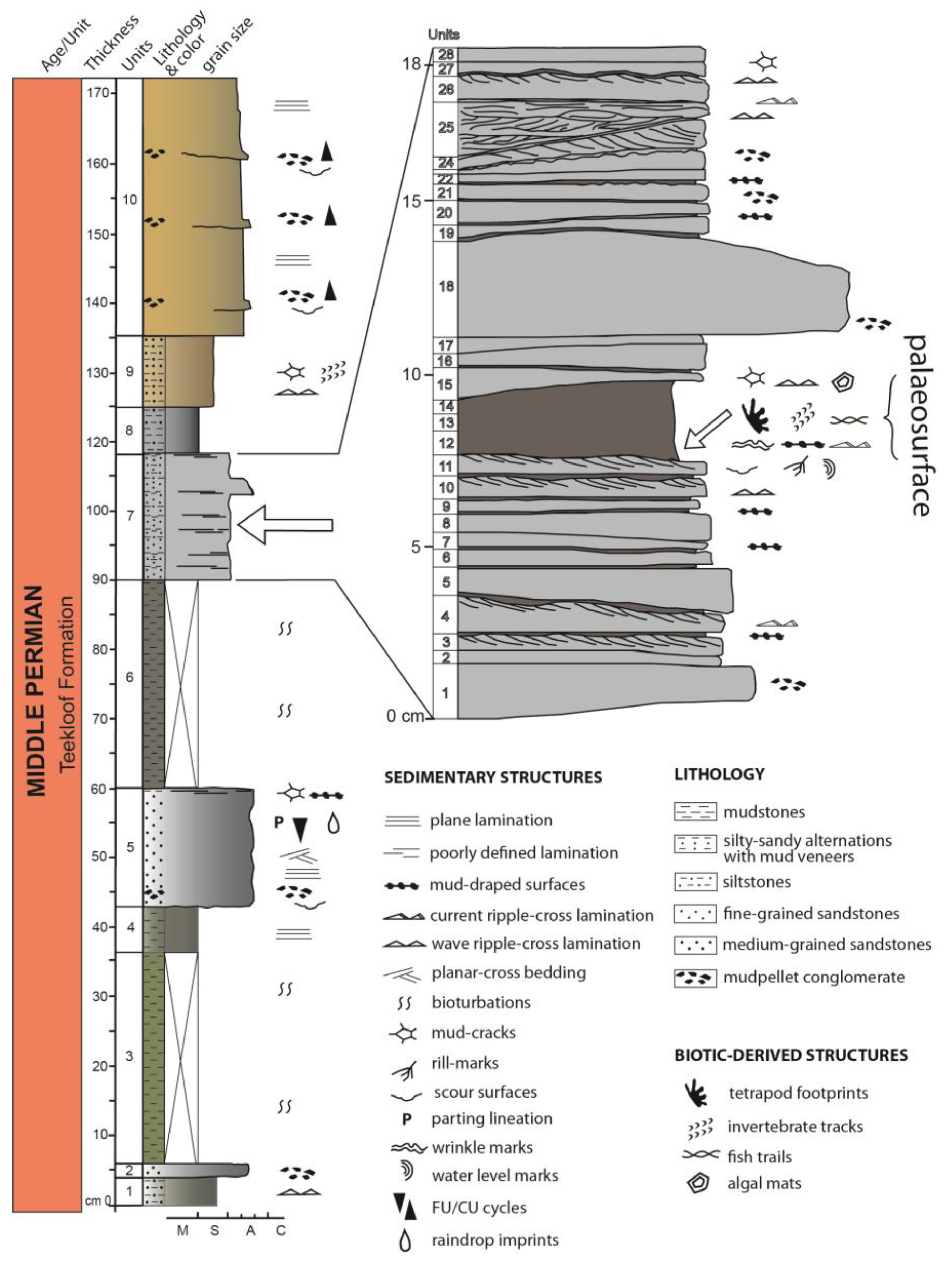
5.1. Lithostratigraphy

The Gansfontein palaeosurface is situated in a flat area that hampers a thick profile description. Reference [3] provided a 3-meter-thick stratigraphic section, probably measuring and also correlating with some outcrops in the surroundings (composite section). Here, we focus on a detailed stratigraphic section (Figure 2) of the Gansfontein site measured at the centimeter scale containing the palaeosurface horizon. The package containing the palaeosurface is analyzed at the millimeter scale (Figure 2).
The stratigraphic log measures about 1.70 m, and its description is from base to top as follows:
  • Unit 1: 4 cm thick dark grey, greenish to silver-colored, massive siltstone layer with straight to sinuous wave ripples;
  • Unit 2: 2 cm thick grey-colored, medium coarse sandstones with sparse mud pellets;
  • Unit 3: 30 cm thick dark olive-green-colored, finely laminated, sub-covered mudstones;
  • Unit 4: 7 cm thick dark gray-greenish-colored, laminated mudstones;
  • Unit 5: 17 cm thick, well-cemented, FU (fining upwards) grey-colored, medium-grained sandstones with erosive base and parallel to low angle ripple cross-lamination; mud pellet layer in the upper part and mud-cracked veneer at the top; raindrop-like imprints also recorded;
  • Unit 6: about 30 cm thick sub-covered, dark grey-greenish-colored, fissile mudstones;
  • Unit 7: about 18 cm thick, massive to finely laminated, grey-colored, very fine sandstones/siltstones with localized dark grey-colored mud veneers. In the first 7 cm from the base, a fine repetition of siltstones/mudstones occurs. Above, a thin mud veneer (about 3 cm) belonging to the middle part of this unit represents the main palaeosurface layer: it allows the preservation of vertebrate and invertebrate traces, several types of sedimentary structures like different kinds of ripples, mud-cracks, algal mats, rill marks, scour marks; in the last 9 cm thick dark gray-colored fine sandstones interspaced with fine siltstones and mm-scale mud surfaces occur again; a wave ripples layer and very large mud cracks at the top; abundant green-colored mud chips layers occur laterally;
  • Unit 8: about 6 cm thick, fissile and cracked, dark grey-colored siltstones/mudstones with mud cracks; sparse calcareous nodules;
  • Unit 9: about 10 cm thick grey to light brown-colored, massive, sandy siltstones with mud-chip conglomerate at the base, ripples, mud cracks, and invertebrate traces;
  • Unit 10: about 37 cm thick yellowish to light green-colored, medium-grained, well-cemented, and sorted feldspathic sandstones with ripple cross-lamination; repeated occurrence of shallow scour surfaces with mud chips, particularly occurring at the base of the unit under even lamination. Such channel sandstones frequently show a lag represented by a mud pellet conglomerate. These intraformational lenticular and thin conglomerates characteristically line channel bottoms on the basal scoured surfaces of cyclothems [52].

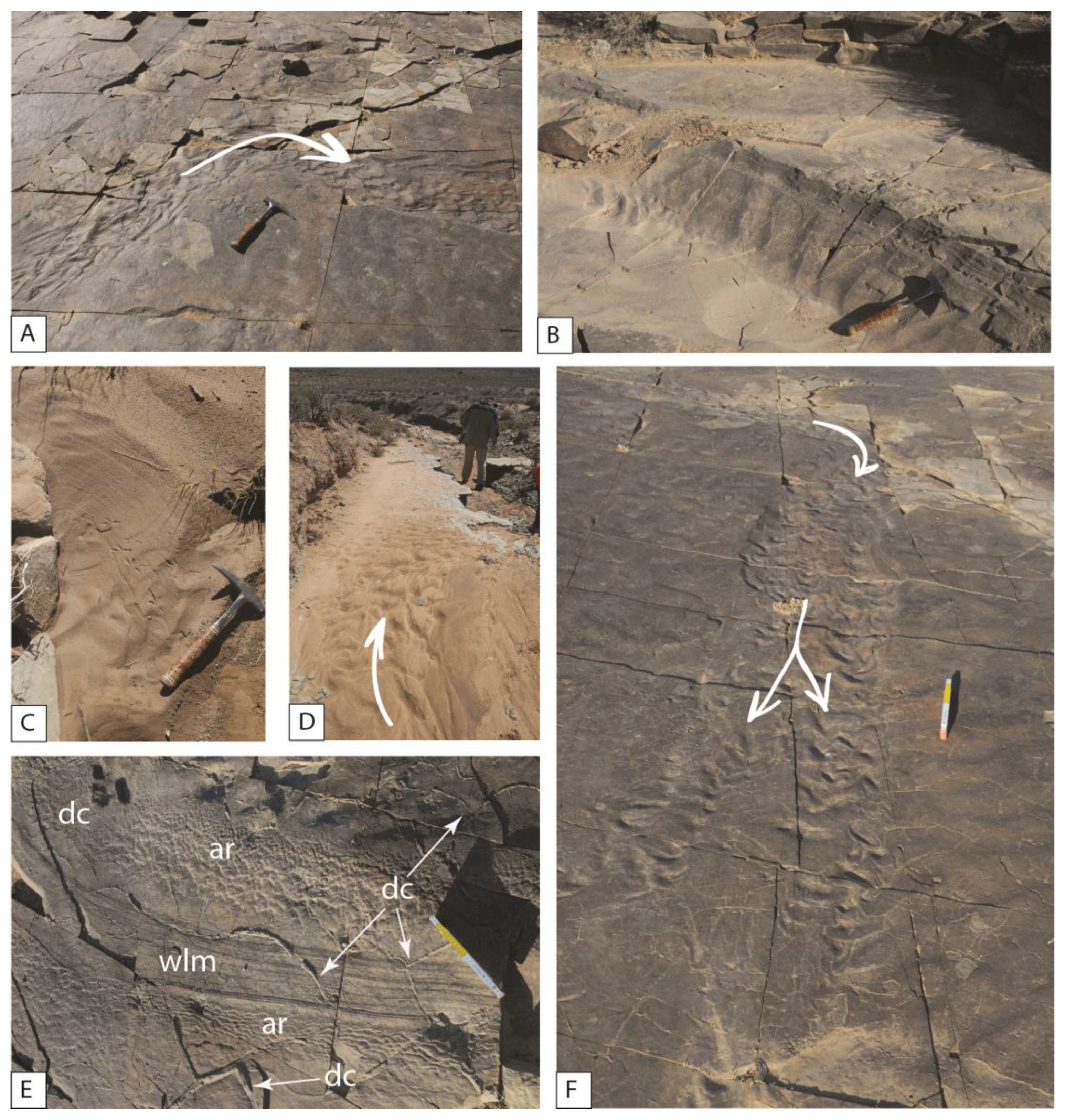
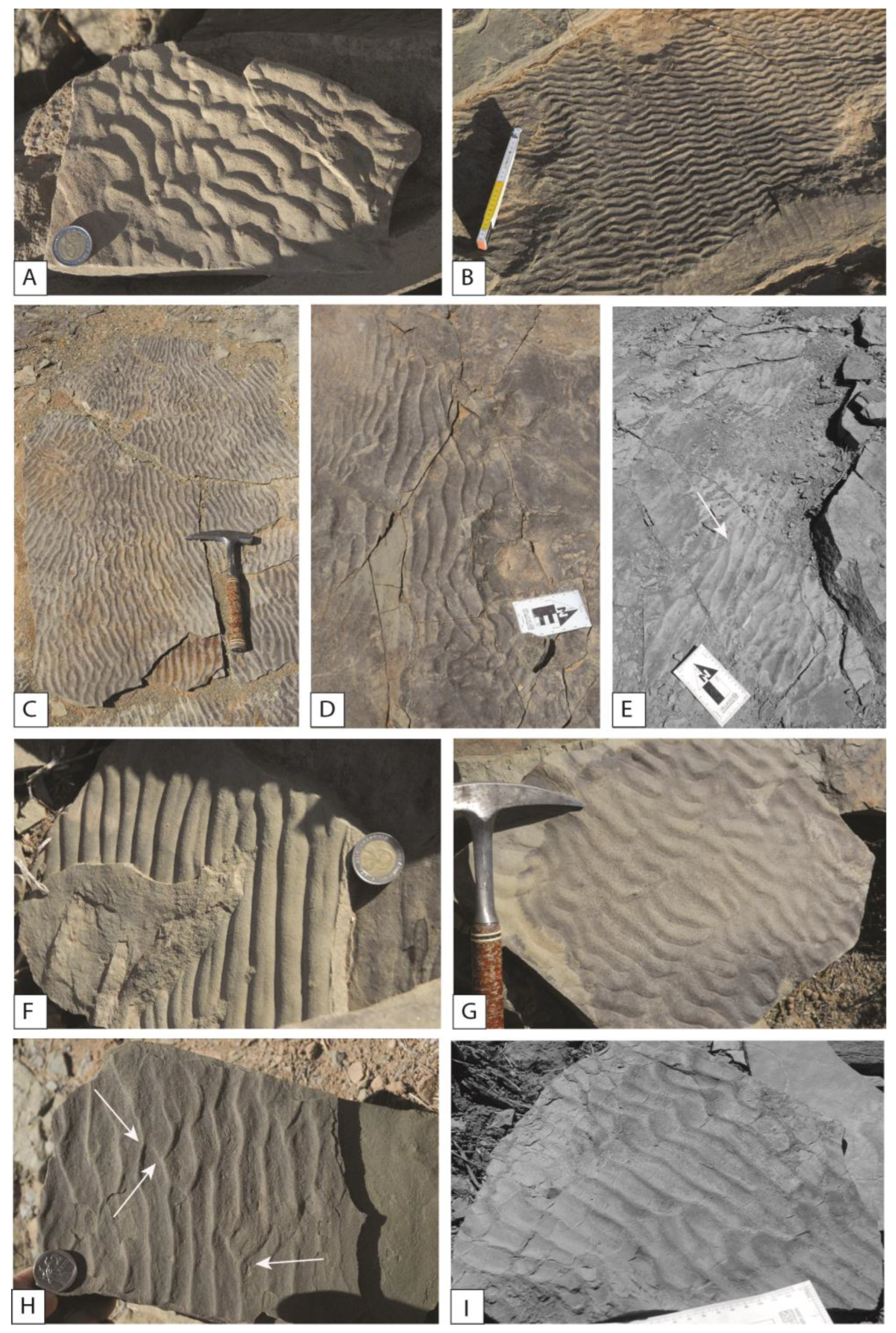
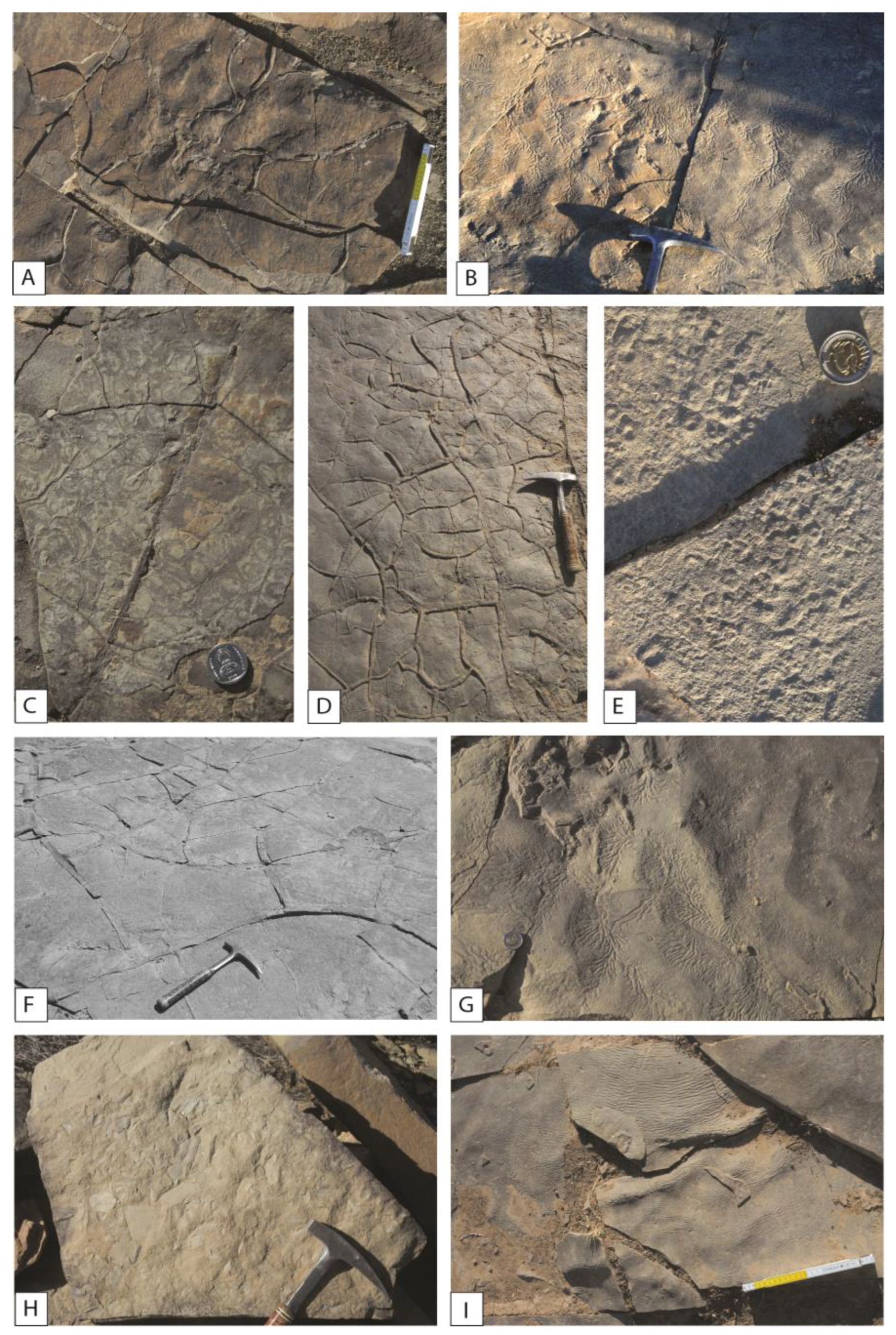
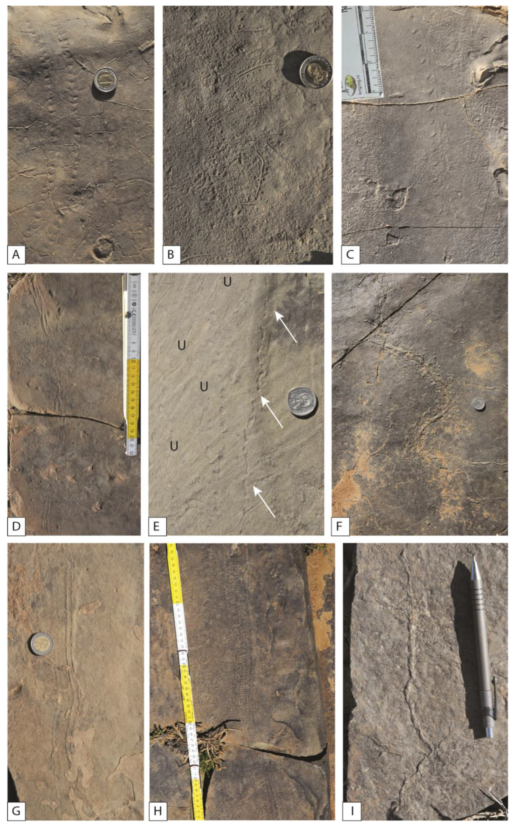
5.2. Sedimentary Structures

In most cases, the original surface topography displays a suite of sedimentary bedding planes, which are commonly overprinted with run-off and desiccation structures, as well as a variety of trace fossils. A thin mudstone veneer that is non-eroded or overprinted by subsequent deposition/sediment re-working has allowed for the preservation of many of the sedimentary structures and high-detail invertebrate and vertebrate traces. This kind of preservation is generally rare, e.g., [4]. The palaeosurface is preserved on the gently undulating upper bedding plane of sheet-like, tabular silty sandstone. The sedimentary structures on the palaeosurface record the fluxes in energy during sediment deposition, ranging from high-energy flows depositing sand to the low-energy, quiet settling of mud from suspension [3,4]. During flooding stages, a series of pools and interpool ridges formed, some of which preserve the vertebrate trackways.
The scour pools are shallow depressions (50–75 cm deep, 2–5 m wide), and their margins contain sedimentary structures denoting falling water levels [4]. Water-level marks on the sandstone bedding planes (Figure 3B,E) are indicative of falling water levels (under very shallow water conditions) and the eventual emergence of the sandy sediments with sudden changes in flow directions and current velocities [52,60]. Sedimentary features related to falling water levels range from ‘emergence’ structures on the lip of the pool margin (consisting of adhesion ripples delimiting the water’s edge (Figure 3E)) to concentric zones of adhesion ‘warts’, which decrease in size downslope and are bounded on the lower margin by run-off rills, indicating the dropping water levels in the pools [3,4,61]. The adhesion ‘warts’ suggest wind shear on the sand with interstitial water.
The pools are often linked by late-stage, narrow, low-sinuosity run-off channels, which appear to have scoured the surface secondarily due to their steep (10 cm high) walls (Figure 3A,F). Pictures of modern run-off channels and pool margins in fine-grained deposits are shown as a comparison (Figure 3C,D). The bases of the narrow run-off channels are covered in linguoid ripples or small antidunes and indicate a higher flow regime (Figure 3A,F and Figure 4A). Drying of the palaeosurface is expressly shown on the interpool ridges as sandstone-filled casts of desiccation cracks.
The bottom of the palaeo-pools preserves small symmetrical oscillation ripples (Figure 4B), while an association of various kinds of wave ripples and current ripples, interference or “ladderback” ripples, and flat-topped ripples occur widely in various sectors of the palaeosurface. Ladderback ripples have been considered diagnostic of late-stage emergence run-off in intertidal environments but are not confined to tide-dominated environments [62]. Asymmetrical wave ripple surfaces are also observed (Figure 4C–E,H): this type of ripple shows well-developed bifurcation of crests, and crests are rather regular [63]. Flat-topped ripple marks (Figure 4F) indicate beveling by wavelets approximately two inches (50 mm) or less deep in water [64].
Fine-ripple cross-lamination or micro-cross-bedding, ubiquitous in the slightly calcareous siltstones and very fine-grained sandstones, gives rise to characteristic rib-and-furrow structures on bedding planes. Desiccation cracks repeatedly occur over fine-grained layers (Figure 5A,D,F), often associated with structureless greyish mudstone. Occasionally, large desiccation cracks form low, polygonal ridges on bedding surfaces, showing algal mats preserved in the mud portions (Figure 5C). In some cases, unconsolidated mud cracks are deformed by the impression of vertebrate footprints (Figure 5C). These dark grey-green mudstones often contain invertebrate traces and sometimes display wrinkled laminae (Figure 5I), formed during subaerial exposure when the wind blew across a sandy surface covered by a thin film of water. Dendritic rill marks occur very often on the rims of the pools or on rippled surfaces (Figure 5B,G). Rarely can raindrop-like imprints (Figure 5E), poorly preserved in whitish silty deposits, be observed.

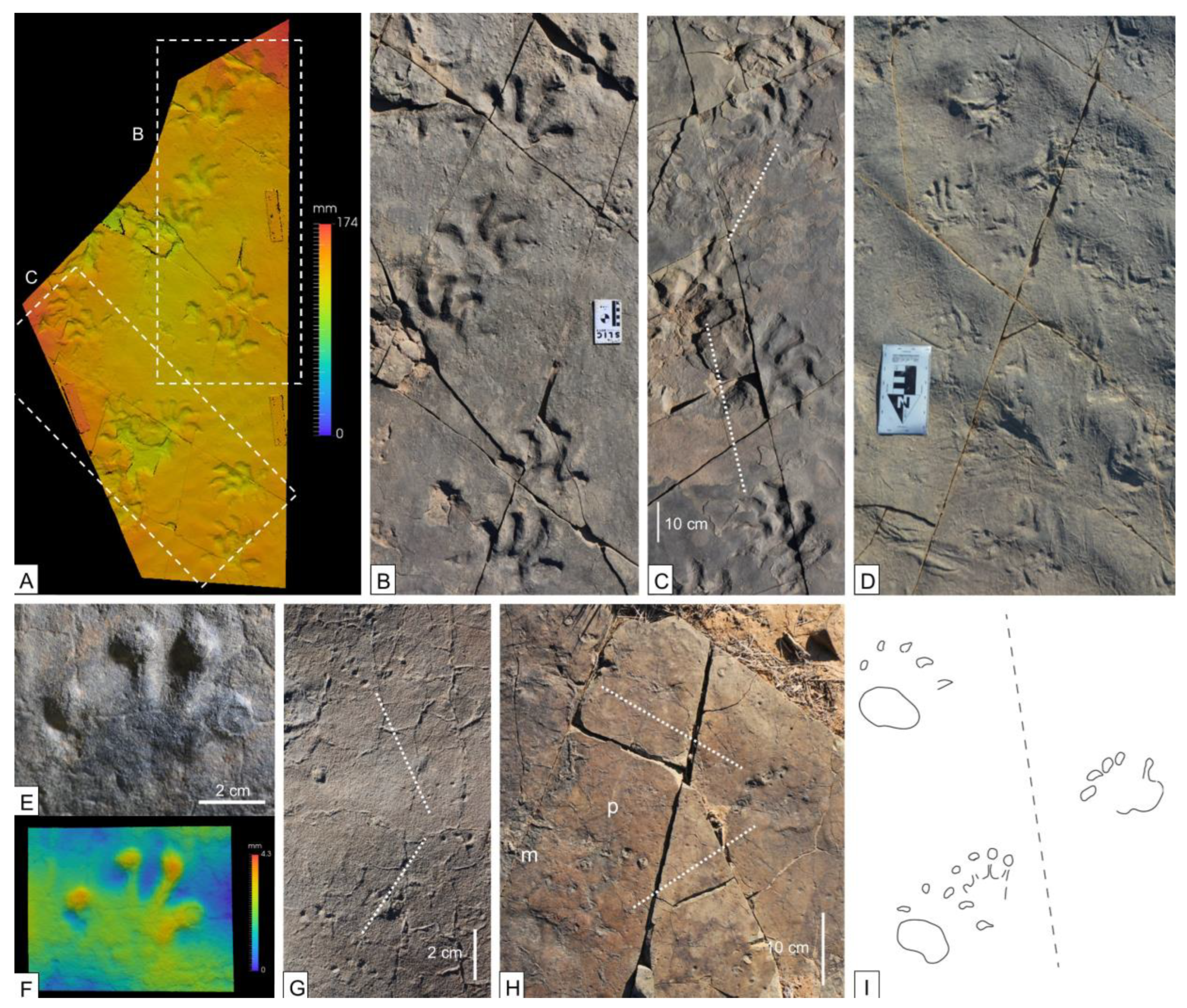
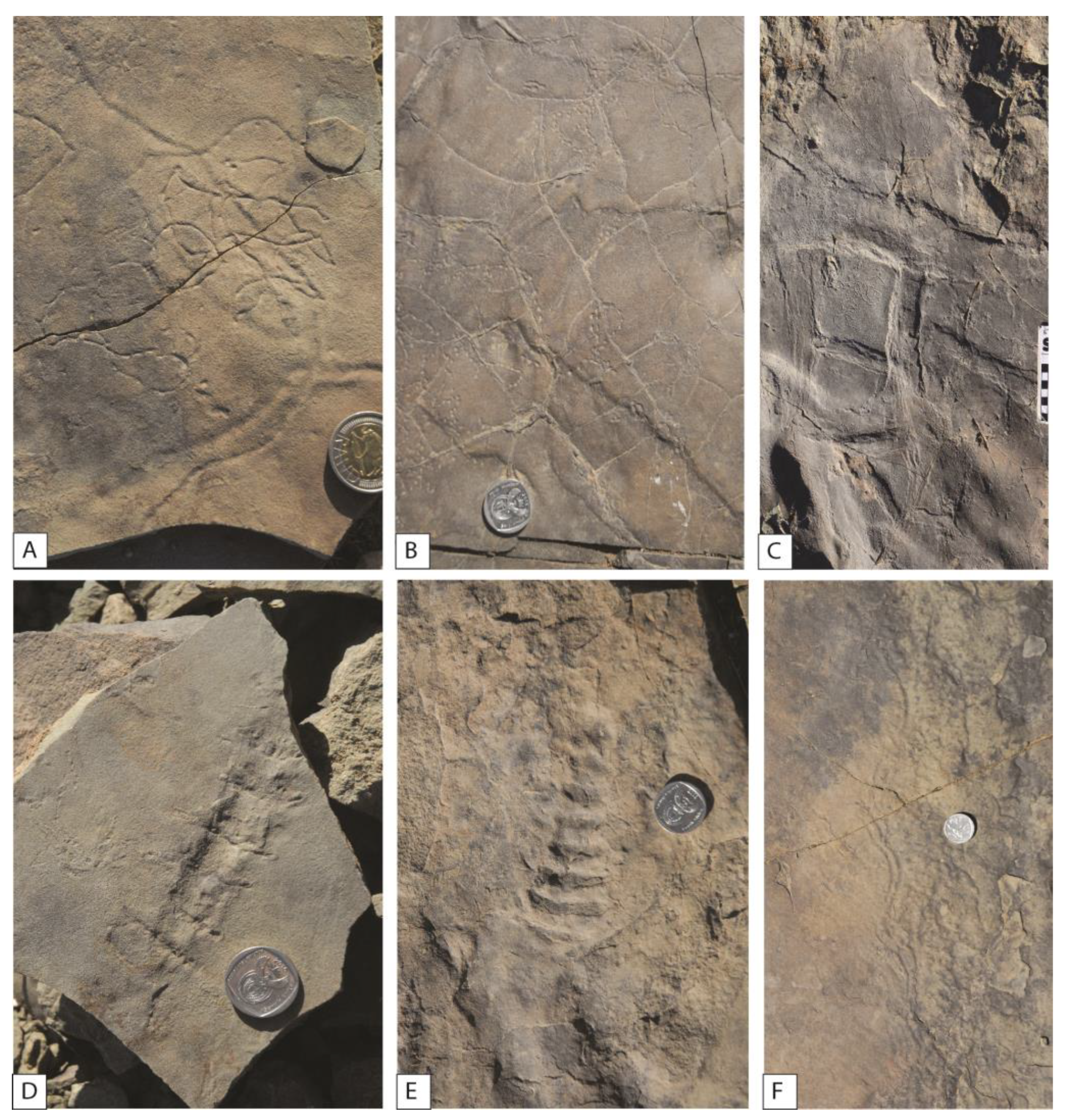
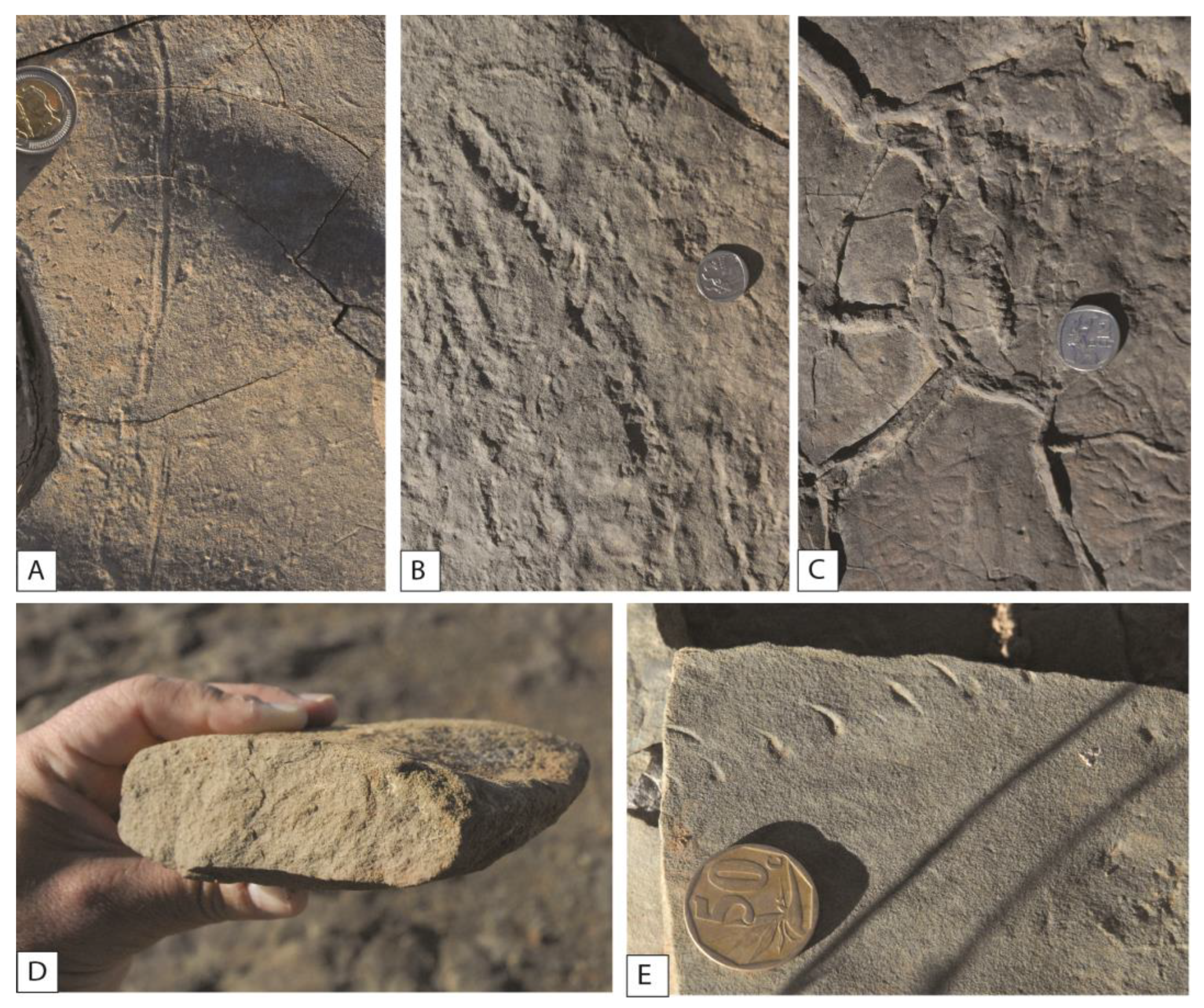
5.3. Vertebrate Trace Fossils

5.3.1. Tetrapod Footprints
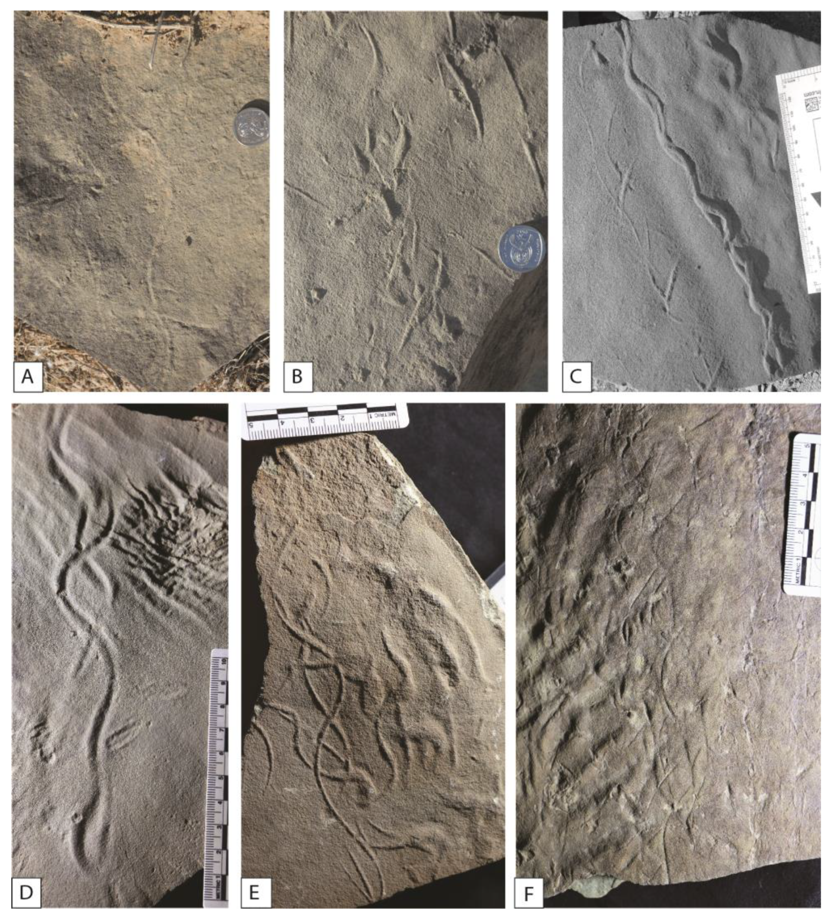
Several trackways are impressed and excellently preserved on the palaeosurface [3,4,7] (Figure 6). The total number of trackways is estimated to be around 20, and the number of tracks around 200. The degree of preservation of the trackways can be seen as largely controlled by the rheology of the substrate (degree of water saturation) and the animal’s body mass and pedal mechanism. It varies considerably, from 0 (worse preservation) to 3 (best preservation). In the first case, the footprints are simple sub-circular holes or indistinct depressions and are not assignable to any ichnotaxon/producer. In the second case, the footprints are wonderfully preserved, showing all details of digit and palm/sole impressions. This is the case of the type of material of Karoopes gansfonteinensis [7].
Modified true tracks preserved on the palaeosurface are from several therapsids, including abundant gorgonopsians, common therocephalians, and rare dicynodonts. Many tracks preferentially preserve expulsion rims due to the visco-elastic rheology of the sediment.
The most common trackway types were assigned to Karoopes gansfonteinensis by the authors of [7] and have previously been referred to as trackway 1 in [3,4]. These are trackways of large quadrupedal tetrapods with pentadactyl manus and pes impressions up to 26 cm long and with a high pace angulation (110–170°) (Figure 6A,C). The distinct gait of the trackmaker is characterized by the inward curvature of the digits towards the trackway-midline. The trackways have formerly been interpreted as being left by dinocephalian therapsids [4]. Ref. [7] comprehensively revised this material and instead attributed it to gorgonopsian therapsids.
These tracks are abundant (more than 100 footprints arranged in several trackways) and show a complete range of preservation, including indistinct broad footprints, digitigrade incomplete footprints, and completely impressed and well-preserved footprints. Often, transitions between different types of preservation are visible along the same trackway. Footprints commonly overprint ripples and rills and are instead cut by mud cracks.
The second most common trackways, assigned to cf. Capitosauroides isp. [7] are preserved adjacent and within a shallow pool and associated with swimming traces (trackway 3) in [4]. The swimming traces are constituted by three parallel elongated traces up to 4 cm long (Figure 6D). They can be attributed to digitigrade, quadrupedal animals walking on saturated sediment and show toe-drag marks. The five-toed manus and pes tracks leave distinct, small, sub-circular pad impressions (Figure 6E–G). The author of [4] attributed these tracks to the small dicynodont Diictodon. The author of [4] considered these trackways as being made subaqueously, based on the claw scrapes and the sedimentary structures, which suggest the margin of a pool. Also, swimming traces are observed, constituted by three parallel elongated traces up to 4 cm long. This material has been comprehensively revised by the authors of [7], who attributed it to therocephalian therapsid producers.
A third track type, of which only one trackway was identified at the Gansfontein site, shows relatively large paw-like impressions (Figure 6H,I). It was assigned to Dolomitipes icelsi and has been attributed to dicynodont therapsids by the authors of [7]. The large sub-circular and indistinct impressions occurring in some parts of the palaeosurface (non-digitiform footprints) of [4] may have been deformed Dolomitipes icelsi tracks; however, a clear assignment is not possible because of their poor preservation.

5.3.2. Fish Trails

The first to report detailed fish trails referred to the ichnogenus Undichna from the Early Permian of the Dwyka and Ecca Series was the author of [1]. This author classified the trails as Undichna simplicitas, U. bina, and U. insolentia.
Ref. [6] also described Undichna traces from the Middleton Formation. The traces display the characteristic morphology of Undichna britannica [65], which has been interpreted as a pair of intertwined waves of different amplitudes generated in soft sediment by the ventrally protruding fins of swimming fishes in freshwater settings [65,66,67]. Combined ichnological and sedimentological evidence suggests there was a low-energy, freshwater lacustrine depositional environment, where occasional higher energy currents brought in nutrients [6].
Undichnia quina and Undichna britannica from the Gansfontein palaeosurface has been described by the authors of [68]. Undichna quina is diagnosed by at least two pairs of intertwined out-of-phase sinusoidal waves, with one pair showing higher amplitudes [68].
Additionally, U. unisulca, the most simple Undichna trace characterized by a single sinuous trail, can be observed (Figure 7A). Undichna trails are very common in the central-western portion of the Gansfontein palaeosurface (Figure 7A–F). It is likely that the tracemakers were trapped in isolated channel bar ponds or shallow pools (precise dimensions unknown) in the waning phase of a flood.

5.3.3. Invertebrate Trace Fossils

Various invertebrate trace fossils also occur on the Gansfontain palaeosurface. Different kinds of bioturbation can be linked to the life activities of shallow infaunal and epifaunal invertebrates, possibly annelids, aquatic oligochaetes, nematodes, insect larvae, and arthropods.
Anyway, the invertebrate traces did not intensively re-work the sediment, thus allowing the preservation of the palaeosurface. In fact, few or no non-horizontal burrows are observed.
Ref. [3] (Figure 4.4) reported an arthropod trackway with a central furrow (?Umfolozia isp.), and the author of [4] (Figure 10) documented further indeterminate arthropod trackways. This material and further trackways (Figure 8A,E) with two parallel rows of evenly spaced impressions are assignable to Diplichnites gouldi (type A) sensu [69]. Further arthropod trackways include two parallel rows of comma-like closely-spaced impressions with a central furrow assignable to Dendroidichnites isp. (Figure 8C) and two parallel sinuous furrows assignable to Diplopodichnus isp. (Figure 8G and Figure 9F). Possibly, arthropod body imprints, first reported by (3, Figure 4.7), can also be found in grey-colored fine sediments on the palaeosurface or in its surroundings (Figure 9D,E).
Horizontal burrows and grazing trails are common on the Gansfontein palaeosurface. The author of [4] (Figure 8) described beaded trails arranged in loops (potentially made by insect larvae). Ref. [8] interpreted these beaded traces as belonging to Fodinichnia, the ethological category of traces that includes deposit feeders. These traces (Figure 9A–C) are assignable to Gordia isp. Further horizontal burrows include Planolites (Figure 10A), first reported from the locality by the author of [3], meniscate burrows (?Scoyenia Figure 10B), and the slightly sinusoidal grazing trace Helminthopsis (Figure 8I). Undetermined mud-loving beetle traces are also recorded (Figure 10C).

6. Discussion

In the Middle Permian, paleosurfaces preserving vertebrate and invertebrate tracks are very rare. Exceptions, but not all specifically ascribed to the Middle Permian, are those reported by the authors of [70] at the transition from the Ecca Group to the Beaufort Group, where a paleosurface preserves a non-marine aquatic setting with numerous ichnofossils, including tetrapod footprints and fish swim-trails, as well as body impressions attributed to rhinesuchid temnospondyl. The Wordian Onder Karoo lagerstatte [71] in the southwestern Karoo Basin also records a very rich lake-shore palaeoecosystem but with mainly insects and plants preserved. Other Permian sites with Undichna, invertebrate traces, and tetrapod footprints are the tidal flat units of the Early Permian Robledo Mountains Formation of New Mexico [72], the long-lived ephemeral water bodies, rich invertebrate–vertebrate tracks, of the Clear Fork Group at Castle Peak in Texas, USA [69], and the fluvial and marginal marine units of the Late Permian Val Gardena Sandstone Formation of Italy [68]. Some Middle Permian basins in Southern France, e.g., [73,74], also show tracks and trails of vertebrates and insects.
Therefore, on the basis of several sedimentological and ichnological aspects, we can hypothesize that this palaeosurface represented an extremely rare depositional setting that was preserved for a likely short time interval (possibly months) into a surrounding much more energetic hydrodynamic depositional environment. The traces were produced during such a time span of shallow water conditions in ponds, which alternated with emerging small and low reliefs. Preservation is most probably attributable to flooding of the floodplain with silt- and mud-rich water but under low energy conditions where the main channels are distant, and the water entered the floodplain lakes via crevasse splay events. The “sudden” but no-erosive covering of the palaeosurface, necessary for the preservation of the trace fossils, could be simply the result of mud settling from the sediment-laden water and subsequent subsidence in the basin, preventing erosion of the palaeosurface during the next major high water stand in the river systems. In particular, the laminated mudstones occurring in the Gansfontein section indicate the slow settling of mud-size particles from suspension.
This is different from the massive mudstones, which are common all throughout the Abrahamskraal Fm. and may be interpreted as a result of a quick deposition (mass movement) or bioturbation disrupting any primary sedimentary structures. In particular, as also stated by the author of [4], the distribution of palaeosurfaces in the Beaufort strata was ultimately controlled by flash floods, which transported sand out of the large mid-Permian meandering river channels into the floodplains. In the case of the Gansfontein palaeosurface, preservation of the vertebrate and invertebrate traces was enhanced by a silty clay veneer that accumulated on the sand surfaces during a waning flood. Also, in the case of the vertebrate footprints, it is very likely that the sandy base favored their preservation by providing stable support, and the silty clay veneer enhanced the preservation of fine details.
It was likely the rapidly fluctuating hydrodynamic regime of the topmost Abrahamskraal Formation and basal Teekloof Formation rivers [52,75] that promoted the formation and preservation of the different kinds of floodplain palaeosurfaces analyzed by Smith [4]. Anyway, the difficulty of preservation of such palaeosurfaces is probably due to both the originally limited area of sedimentary environments in which they were formed and the mechanical weathering that rapidly destroyed the fragile surfaces soon after they were exposed [4].
The tetrapod footprints are generally superimposing ripples and rill structures, suggesting a subsequent passage of the trackmaker, i.e., after the dynamic phase of the flow. The very variable preservation suggests that the rheologic conditions of the sediment varied through time (different preservation in the same spot) and area (different preservation along the same trackway). In any case, the exposure time was sufficient for the sediment to pass from completely water-saturated (indistinct footprints) to plastic (good footprint preservation) to dry (digitigrade footprints). Also, the tracks are commonly cut by mud cracks, testifying to a drying process before burial. Some tracks were clearly associated with pools because they preserved sliding and swimming traces together with locomotion traces.
According to the authors of [76], who studied the response of modern macroinvertebrate communities after river floods, over the short term, their diversity decreased when compared to pre-flood levels, whereas total macroinvertebrate density remained unchanged. Over the long term (1 and 10 years after the floods), macroinvertebrate diversity and community structure at the studied site returned to pre-flood levels without increasing reference conditions. This is consistent with the invertebrate ichnoassociation observed at the Gansfontein palaeosurface, which is not very diverse and also shows a low disparity, sensu [10], with a prevalence of surface trackways, grazing trails, and resting traces. This represents a typical depaupered Scoyenia ichnofacies, typical of floodplain depositional environments [11].
The lack of infaunal traces and the simultaneous abundance of surface traces are in agreement with a relatively short time interval of deposition and rapid burial. The occurrence of subaqueous grazing traces, as well as swimming traces of fish and tetrapods and the clear presence of pools and rills, testify to the occurrence of localized but interconnected small water bodies.
Undoubtedly, the Gansfontein palaeosurface is a true substrate, sensu [77], i.e., a preserved surface that demonstrably existed at the sediment–water or sediment–air interface at the time of deposition. These surfaces possess, e.g., [71], high value as repositories of palaeoenvironmental information, revealing fossilized snapshots of microscale topography from deep time. Again, according to the above-cited authors, “true substrates are fundamentally related to a state of stasis in ancient sedimentation systems, and distinguishable from other types of bedding surfaces that formed from a dominance of states of deposition or erosion. Stasis is shown to play a key role in both their formation and preservation, rendering them faithful and valuable archives of palaeoenvironmental and temporal information” [77] (p. 1).
On the basis of the many and different sedimentary structures and sedimentologic inferences, we can argue that the Gansfontein palaeosurface formed in a medium-to-distal crevasse splay (Figure 11), which represented a topographic “high” with respect to the alluvial plain areas, and thus could permit a longer preservation of the surface before its definitive sealing by a flood or alternatively by flooding of the entire floodplain area during the next flood cycle of the main river system.

7. Conclusions

Palaeosurfaces like the one described in this discussion are very important as repositories of palaeoenvironmental information because they reveal a kind of fossilized snapshot of micro- to mesoscale topography from deep time. They are notable for their sedimentary structures and for the numerous preserved vertebrate and invertebrate traces, providing insight into the environment of a key interval of Earth’s history. The Gansfontein “oasis” represents a unique window to a distinct animal community and habitat, permitting the acquisition of detailed data on Middle Permian life in continental areas of Southern Gondwana.

Author Contributions

Conceptualization, A.R. and L.M.; methodology, A.R., L.M. and H.K.; software, L.M.; validation, A.R., L.M., H.K. and G.H.G.; formal analysis, A.R. and L.M.; investigation, A.R., L.M., H.K. and G.H.G.; resources, A.R., L.M., H.K. and G.H.G.; data curation, A.R., L.M., H.K. and G.H.G.; writing—original draft preparation, A.R.; writing—review and editing, A.R. and L.M.; visualization, A.R., L.M., H.K. and G.H.G. All authors have read and agreed to the published version of the manuscript.

Funding

This research received no external funding.

Data Availability Statement

The presented data are available on request from the corresponding author.

Acknowledgments

We are indebted to the Fraserburg Museum guide Martinez and his son for kindly permitting access to the site. We are also grateful to Claire Browing (Iziko South African Museum) for permitting access to the ichnological collections. The authors are very grateful to Geosciences Editor, Assistant Editor and two anonymous reviewers for their thorough suggestions, which ameliorated the manuscript.

Conflicts of Interest

The authors declare no conflict of interest.

References

  1. Anderson, A.M. Fish trails from the Early Permian of South Africa. Palaeontology 1976, 19, 397–409. [Google Scholar]
  2. Anderson, A.M. The Umfolozia arthropod trackways in the Permian Dwyka and Ecca series of South Africa. J. Paleont. 1981, 55, 84–108. [Google Scholar]
  3. De Beer, C.H. Surface markings, reptilian footprints and trace fossils on a palaeosurface in the Beaufort Group near Fraserburg, C.P. Ann. Geol. Surv. S. Afr. 1986, 20, 129–140. [Google Scholar]
  4. Smith, R.M.H. Sedimentology and Ichnology of Floodplain Palaeosurfaces in the Beaufort Group (Late Permian), Karoo Sequence, South Africa. Palaios 1993, 8, 339–357. [Google Scholar] [CrossRef]
  5. de Klerk, W.J. A dicynodont trackway from the Cistecephalus assemblage zone in the Karoo, east of Graaff-Reinet, South Africa. Paleont. Afr. 2002, 38, 73–91. [Google Scholar]
  6. Bordy, E.M.; Linkermann, S.; Prevec, R. Palaeoecological aspects of some invertebrate trace fossils from the mid-to upper Permian Middleton formation (Adelaide Subgroup, Beaufort group, Karoo Supergroup), eastern Cape, South Africa. J. Afr. Earth Sci. 2011, 61, 238–244. [Google Scholar] [CrossRef]
  7. Marchetti, L.; Klein, H.; Buchwitz, M.; Ronchi, A.; Smith, R.; deKlerk, W.; Sciscio, L.; Groenwald, G. Permian-Triassic vertebrate footprints from South Africa: Ichnotaxonomy, producers and biostratigraphy through two major faunal crises. Gondw. Res. 2019, 72, 139–168. [Google Scholar] [CrossRef]
  8. Bordy, E.M. Field Guide: A guide to the ichnology and geology of the Main Karoo Basin South Africa and Lesotho. In Proceedings of the 2nd International Conference on Continental Ichnology, Western Cape Winelands, South Africa, 1–8 October 2017. [Google Scholar]
  9. Buatois, L.A.; Mángano, M.G. Ichnology: Organism-Substrate Interactions in Space and Time; Cambridge University Press: Cambridge, UK, 2011. [Google Scholar]
  10. Buatois, L.A.; Wisshak, M.; Wilson, M.A.; Mángano, M.G. Categories of architectural designs in trace fossils: A measure of ichnodisparity. Earth-Sci. Rev. 2017, 164, 102–181. [Google Scholar] [CrossRef]
  11. Marchetti, L.; Belvedere, M.; Voigt, S.; Klein, H.; Castanera, D.; Díaz-Martínez, I.; Farlow, J.O. Defining the morphological quality of fossil footprints. Problems and principles of preservation in tetrapod ichnology with examples from the Palaeozoic to the present. Earth-Sci. Rev. 2019, 193, 109–145. [Google Scholar] [CrossRef]
  12. Neveling, J. Stratigraphic and sedimentological investigation of the contact between the Lystrosaurus and the Cynognathus Assemblage Zones (Beaufort Group: Karoo Supergroup). Council Geosci. Bull. 2004, 137, 164. [Google Scholar]
  13. Rubidge, B.S. 27th Du Toit Memorial Lecture: Re-uniting lost continents—Fossil reptiles from the ancient Karoo and their wanderlust. S. Afr. J. Geol. 2005, 108, 135–172. [Google Scholar] [CrossRef]
  14. Smith, R.M.; Ward, P.D. Pattern of vertebrate extinctions across an event bed at the Permian-Triassic boundary in the Karoo Basin of South Africa. Geology 2001, 29, 1147–1150. [Google Scholar] [CrossRef]
  15. Retallack, G.J.; Metzger, C.A.; Greaver, T.; Jahren, A.H.; Smith, R.M.; Sheldon, N.D. Middle-Late Permian mass extinction on land. GSA Bull. 2006, 118, 1398–1411. [Google Scholar] [CrossRef]
  16. Coney, L.; Reimold, W.U.; Hancox, P.J.; Mader, D.; Koeberl, C.; McDonald, I.; Struck, U.; Vajda, V.; Kamo, S.L. Geochemical and mineralogical investigation of the Permian–Triassic boundary in the continental realm of the southern Karoo Basin. South Africa. Palaeoworld 2007, 16, 67–104. [Google Scholar] [CrossRef]
  17. Fildani, A.; Weislogel, A.; Drinkwater, N.J.; McHargue, T.; Tankard, A.; Wooden, J.; Hodgson, D.; Flint, S. U-Pb zircon ages from the southwestern Karoo Basin, South Africa— implications for the Permian-Triassic boundary. Geology 2009, 37, 719–722. [Google Scholar] [CrossRef]
  18. Lanci, L.; Tohver, E.; Wilson, A.; Flint, S. Upper Permian magnetic stratigraphy of the lower Beaufort group, Karoo basin. Earth Plan. Sci. Lett. 2013, 375, 123–134. [Google Scholar] [CrossRef]
  19. Rubidge, B.S.; Erwin, D.H.; Ramezani, J.; Bowring, S.A.; de Klerk, W.J. High-precision temporal calibration of Late Permian vertebrate biostratigraphy: U-Pb zircon constraints from the Karoo Supergroup, South Africa. Geology 2013, 41, 363–366. [Google Scholar] [CrossRef]
  20. Gastaldo, R.A.; Kamo, S.L.; Neveling, J.; Geissman, J.W.; Bamford, M.; Looy, C.V. Is the vertebrate-defined Permian-Triassic boundary in the Karoo Basin, South Africa, the terrestrial expression of the end-Permian marine event? Geology 2015, 43, 939–942. [Google Scholar] [CrossRef]
  21. Day, M.O.; Ramezani, J.; Bowring, S.A.; Sadler, P.M.; Erwin, D.H.; Abdala, F.; Rubidge, B.S. When and how did the terrestrial mid-Permian mass extinction occur? Evidence from the tetrapod record of the Karoo Basin, South Africa. Proc. Royal Soc. B 2015, 282, 20150834. [Google Scholar] [CrossRef]
  22. Day, M.O.; Ramezani, J.F.; Ryan, E.; Rubidge, B.S. U-Pb zircon age constraints on the vertebrate assemblages and palaeomagnetic record of the Guadalupian Abrahamskraal Formation, Karoo Basin, South Africa. J. Afr. Earth Sci. 2022, 186. [Google Scholar] [CrossRef]
  23. Turner, B.R. Uranium mineralization in the Karoo Basin, South Africa. Economic Geol. 1985, 80, 256–269. [Google Scholar] [CrossRef]
  24. Smith, R.M.H. Morphology and depositional history of exhumed Permian point-bars in the southwestern Karoo, South Africa. J. Sediment. Petrol. 1987, 57, 19–29. [Google Scholar]
  25. Smith, R.M.H. Alluvial palaeosols and pedofacies sequences in the Permian Lower Beaufort of the southwestern Karoo Basin, South Africa. J. Sediment. Petrol. 1990, 60, 258–276. [Google Scholar]
  26. Stear, W.M. Morphological characteristics of ephemeral stream channel and overbank splay sandstone bodies in the Permian Lower Beaufort Group, Karoo Basin, South Africa. In Modern and Ancient Fluvial Systems; Collinson, J.D., Lewin, J., Eds.; International Association of Sedimentologists IAS: Princeton, NJ, USA, 1983; Volume 6, pp. 405–420. [Google Scholar]
  27. Smith, R.M.H. Changing fluvial environments across the Permian-Triassic boundary in the Karoo Basin, South Africa and possible causes of tetrapod extinctions Palaeogeogr. Palaeoclimatol. Palaeoecol. 1995, 117, 81–104. [Google Scholar] [CrossRef]
  28. Smith, R.M.H. Sedimentology and Taphonomy of the Lower Beaufort Strata Near Beaufort West, Cape Province. Master’s Thesis, University of Witwatersrand, Johannesburg, South Africa, 1981; p. 126. [Google Scholar]
  29. Loock, J.C.; Brynard, H.J.; Heard, R.G.; Kitchin, J.W.; Rubidge, B.S. The stratigraphy of the Lower Beaufort Group in an area north of Laingsburg, South Africa. J. Afr. Earth Sci. 1994, 18, 185–195. [Google Scholar] [CrossRef]
  30. Johnson, M.R.; Van Vuuren, C.J.; Visser, J.N.J.; Cole, D.I.; Wickens, H.D.V.; Christie, A.D.M.; Roberts, D.L. The Foreland Karoo Basin, South Africa. In African Basins. Sedimentary Basins of the World, 3; Selly, R.C., Ed.; Elsevier Science B.V: Amsterdam, The Netherlands, 1997; pp. 269–317. [Google Scholar]
  31. Johnson, M.R.; Van Vauuren, C.J.; Visser, J.N.J.; Cole, D.I.; de Wickens, H.; Christie, A.D.M.; Roberts, D.L.; Brandl, G. Sedimentary Rocks of the Karoo Supergroup. In The Geology of South Africa; Johnson, M.R., Anhaeusser, C.R., Thomas, R.J., Eds.; Geological Society of South Africa, Johannesburg/Council for Geoscience: Pretoria, South Africa, 2006; pp. 461–501. [Google Scholar]
  32. Keyser, A.W.; Smith, R.H.M. Vertebrate biozonation of the Beaufort Group with special reference to the western Karoo basin. Ann. Geol. Surv. South Africa 1979, 12, 1–3. [Google Scholar]
  33. Mason, R.; Rubidge, B.; Hancox, J. Terrestrial vertebrate colonisation and the Ecca-Beaufort boundary in the southeastern main Karoo Basin, South Africa: Implications for Permian Basin evolution. S. Afr. J. Geol. 2015, 118, 145–156. [Google Scholar] [CrossRef]
  34. Rubidge, B.S.; Hancox, P.J.; Catuneanu, O. Sequence analysis of the Ecca-Beaufort contact in the southern Karoo of South Africa. S. Afr. J. Geol. 2000, 103, 81–96. [Google Scholar] [CrossRef]
  35. Smith, R.M.H. A review of stratigraphy and sedimentary environments of the Karoo Basin of South Africa. J. Afr. Earth Sci. 1990, 10, 117–137. [Google Scholar] [CrossRef]
  36. Le Roux, P.J. Palaeochannels and Uranium Mineralisation in the Main Karoo Basin of South Africa. Ph.D. Thesis, University of Port Elizabeth, Port Elizabeth, South Africa, 1985; p. 250. [Google Scholar]
  37. Jirah, S.; Rubidge, B.S. Refined stratigraphy of the middle Permian Abrahamskraal Formation (Beaufort Group) in the southern Karoo basin. J. Afr. Earth Sci. 2014, 100, 121–135. [Google Scholar] [CrossRef]
  38. Cole, D.I.; Johnson, M.R.; Day, M.O. Lithostratigraphy of the Abrahamskraal Formation (Karoo Supergroup), South Africa. S. Afr. J. Geol. 2016, 119, 415–424. [Google Scholar] [CrossRef]
  39. Day, M.O.; Rubidge, B.S. A brief lithostratigraphic review of the Abrahamskraal and Koonap formations of the Beaufort Group, South Africa: Towards a basin-wide stratigraphic scheme for the Middle Permian Karoo. J. Afr. Earth Sci. 2014, 100, 227–242. [Google Scholar] [CrossRef]
  40. Rubidge, B.S. Biostratigraphy of the Beaufort Group (Karoo Supergroup); Biostratigraphic Series 1; South African Commission for Stratigaphy: Pretoria, South Africa, 1995; pp. 1–45. [Google Scholar]
  41. Smith, R.M.H.; Keyser, A. Biostratigraphy of the Tapinocephalus Assemblage Zone. In Biostratigraphy of the Beaufort Group (Karoo Supergroup); South African Committee for Stratigraphy, Biostratigraphic Series; Rubidge, B.S., Ed.; Council for Geoscience: Pretoria, South Africa, 1995; Volume 1, pp. 8–12. [Google Scholar]
  42. Smith, R.M.H.; Keyser, A.W. Biostratigraphy of the Pristerognathus Assemblage Zone. In Biostratigraphy of the Beaufort Group (Karoo Supergroup); South African Committee for Stratigraphy, Biostratigraphic Series; Rubidge, B.S., Ed.; Council for Geoscience: Pretoria, South Africa, 1995; Volume 1, pp. 13–17. [Google Scholar]
  43. Smith, R.M.H. Biostratigraphy of the Cistecephalus Assemblage Zone (Beaufort Group, Karoo Supergroup), South Africa. S. Afr. J. Geol. 2020, 123, 181–190. [Google Scholar] [CrossRef]
  44. Mason, R. A Bio- and Litho- Stratigraphic Study of the Ecca-Beaufort contact in the southeastern Karoo Basin (Albany District, Eastern Cape Province). Master’s Thesis, University of the Witwatersrand, Johannesburg, South Africa, 2007; p. 147. [Google Scholar]
  45. Viglietti, P.A.; Rubidge, B.S.; Smith, R.M.H. Revised lithostratigraphy of the Upper Permian Balfour and Teekloof formations of the main Karoo Basin, South Africa. S. Afr. J. Geol. 2017, 120, 45–60. [Google Scholar] [CrossRef]
  46. Lucas, S.G. Timing andmagnitude of tetrapod extinctions across the Permo-Triassic boundary. J. Asian Earth Sci. 2009, 36, 491–502. [Google Scholar] [CrossRef]
  47. Day, M.O.; Güven, S.; Abdala, F.; Jirah, S.; Rubidge, B.; Almond, J. Youngest dinocephalian fossils extend the Tapinocephalus Zone, Karoo Basin, South Africa. S. Afr. J. Sci. 2015, 111, e2014-0309. [Google Scholar] [CrossRef]
  48. Day, M.O.; Smith, R.M.H. Biostratigraphy of the Endothiodon Assemblage Zone (Beaufort Group, Karoo Supergroup), South Africa. S. Afr. J. Geol. 2020, 123, 165–180. [Google Scholar] [CrossRef]
  49. Lanci, L.; Galeotti, S.; Ratcliffe, K.; Tohver, E.; Wilson, A.; Flint, S. Astronomically forced cycles in Middle Permian fluvial sediments from Karoo Basin (South Africa). Palaeogeogr. Palaeoclimatol, Palaeoecol. 2022, 596, 110973. [Google Scholar] [CrossRef]
  50. Turner, B.R. Sedimentary patterns of uranium mineralization the Beaufort Group of the southern Karoo (Gondwana) basin, South Africa. Can. Soc. Petrol. Geologists 1978, 5, 831–848. [Google Scholar]
  51. Pretorius, L.E. Aspects of Uranium Mineralization in the Beaufort West Karoo. Master’s Thesis, Stellenbosch University, Stellenbosch, South Africa, 1977; p. 116. [Google Scholar]
  52. Stear, W.M. Sedimentary structures related to fluctuating hydrodynamic conditions in flood plain deposits of the Beaufort Group near Beaufort West, Cape. Trans. Geol. Soc. S. Afr. 1978, 81, 393–399. [Google Scholar]
  53. Stear, W.M. The Sedimentary Environment of the Beaufort Group Uranium Province in the Vicinity of Beaufort West, South Africa. Ph.D. Thesis, University of Port Elizabeth, Port Elizabeth, South Africa, 1980; p. 188. [Google Scholar]
  54. Bordy, E.M.; Smith, R.M.H.; Choiniere, J.N.; Rubidge, B.S. Selected Karoo Geoheritage Sites of Paleontological Significance in South Africa and Lesotho; Geological Society of London: London, UK, 2024. [Google Scholar] [CrossRef]
  55. Day, M.O.; Rubidge, B.S. Biesiespoort revisited: A case study on the relationship between tetrapod assemblage zones and Beaufort lithostratigraphy south of Victoria West. Palaeont. Afr. 2019, 53, 51–65. [Google Scholar]
  56. Marchetti, L.; Logghe, A.; Mujal, E.; Barrier, P.; Montenat, C.; Nel, A.; Steyer, J.S. Vertebrate tracks from the Permian of Gonfaron (Provence, Southern France) and their implications for the late Capitanian terrestrial extinction event. Palaeogeogr. Palaeoclimatol. Palaeoecol. 2022, 599, 111043. [Google Scholar] [CrossRef]
  57. Kammerer, C.F.; Rubidge, B.S. The earliest gorgonopsians from the Karoo Basin of South Africa. J. Afr. Earth Sci. 2022, 194, 104631. [Google Scholar] [CrossRef]
  58. Day, M.O.; Rubidge, B.S. The Late Capitanian mass extinction of terrestrial vertebrates in the Karoo Basin of South Africa. Frontiers Earth Sci. 2021, 9, 631198. [Google Scholar] [CrossRef]
  59. Smith, R.M.; Angielczyk, K.D.; Benoit, J.; Fernandez, V. Neonate aggregation in the Permian dicynodont Diictodon (Therapsida, Anomodontia): Evidence for a reproductive function for burrows? Palaeogeogr. Palaeoclimatol. Palaeoecol. 2021, 569, 110311. [Google Scholar] [CrossRef]
  60. Klein, G.D. A sedimentary model for determining paleotidal range. Bull. Geol. Soc. Am. 1971, 82, 2585–2592. [Google Scholar] [CrossRef]
  61. Olsen, H.; Due, P.H.; Clemmensen, L.B. Morphology and genesis of asymmetric adhesion warts--a new adhesion surface structure. Sed. Geol. 1989, 61, 277–285. [Google Scholar] [CrossRef]
  62. Ramsay, P.J.; Cooper, J.A.G.; Wright, C.I.; Mason, T.R. The occurrence and formation of ladderback ripples in subtidal, shallow-marine sands, Zululand, South Africa. Marine Geol. 1989, 86, 229–235. [Google Scholar] [CrossRef]
  63. Reineck, H.-E.; Singh, I.B. Depositional Sedimentary Environments; Springer: Berlin/Heidelberg, Germany, 1975; p. 439. [Google Scholar]
  64. Tanner, W.F. An occurrence of Flat-Topped Ripple Marks. J. Sedim. Petrol. 1958, 28, 95–96. [Google Scholar] [CrossRef]
  65. Higgs, R. Fish trails in the Upper Carboniferous of southwest England. Palaeontology 1988, 31, 255–272. [Google Scholar]
  66. Gibert, J.M.; Buatois, L.A.; Fregenal-Martinez, M.A.; Mángano, M.G.; Ortega, F.; Poyato-Ariza, F.J.; Wenz, S. The fish trace fossil Undichna from the Cretaceous of Spain. Palaeontology 1999, 42, 409–427. [Google Scholar] [CrossRef]
  67. Trewin, N.H. The ichnogenus Undichna, with examples from the Permian of the Falkland Islands. Palaeontology 2000, 43, 979–997. [Google Scholar] [CrossRef]
  68. Ronchi, A.; Santi, G.; Marchetti, L.; Bernardi, M.; Gianolla, P. First report of swimming trace fossils of fish from the Upper Permian and Lower Triassic of the Dolomites (Italy). Ann. Soc. Geol. Poloniae 2018, 88, 111–125. [Google Scholar] [CrossRef]
  69. Minter, N.J.; Krainer, K.; Lucas, S.G.; Braddy, S.J.; Hunt, A.P. Palaeoecology of an Early Permian playa lake trace fossil assemblage from Castle Peak, Texas, USA. Palaeogeogr. Palaeoclimatol. Palaeoecol. 2007, 246, 390–423. [Google Scholar] [CrossRef]
  70. Groenewald, D.P.; Krüger, A.; Day, M.O.; Penn- Clarke, C.R.; Hancox, P.J.; Rubidge, B.S. Unique trackway on Permian Karoo shoreline provides evidence of temnospondyl locomotory behaviour. PLoS ONE 2023, 18, e0282354. [Google Scholar] [CrossRef]
  71. Prevec, R.; Nel, A.; Day, M.O.; Muir, R.A.; Matiwane, A.; Kirkaldy, A.P.; Barber-James, H.M. South African Lagerstätte reveals middle Permian Gondwanan lakeshore ecosystem in exquisite detail. Commun. Biol. 2022, 5, 1154. [Google Scholar] [CrossRef]
  72. Minter, N.J.; Braddy, S.J. Ichnology of an early Permian intertidal flat: The Robledo Mountains Formation of southern New Mexico, US. In Special Papers in Paleontology 82; The Palaeontological Association: London, UK, 2009. [Google Scholar]
  73. Garrouste, R.; Nel, A.; Gand, G. New fossil arthropods (Notostraca and Insecta: Syntonopterida) in the continental Middle Permian of Provence (Bas-Argens Basin, France). Comptes Rendus Palevol 2009, 8, 49–57. [Google Scholar] [CrossRef]
  74. Moreau, J.-D.; Michelin, A.; Fara, E.; Gand, G.; Galtier, J.; Puech, G.; Fouché, S. Ichnofossils and body fossils from the Permian of the Sorgue Valley (Saint-Affrique Basin, southern France): Palaeoenvironmental implications. Hist. Biol. 2022. [Google Scholar] [CrossRef]
  75. Stear, W.M. Comparison of the bedform distribution and dynamics of modern and ancient sandy ephemeral flood deposits in the southwestern Karoo region, South Africa. Sed. Geol. 1985, 45, 209–230. [Google Scholar] [CrossRef]
  76. Rader, R.B.; Voelz, N.J.; Ward, J.V. Post-flood recovery of a macroinvertebrate community in a regulated river: Resilience of an anthropogenically altered ecosystem. Restor. Ecol. 2008, 16, 24–33. [Google Scholar] [CrossRef]
  77. Davies, N.S.; Shillito, A.P. True substrates: The exceptional resolution and unexceptional preservation of deep time snapshots on bedding surfaces. Sedimentology 2021, 68, 3307–3356. [Google Scholar] [CrossRef]
Figure 1. (A) Location of the Gansfontein palaeosurface. (B) Position of the palaeosurface in the Fraserburg–Williston area. (C) Stratigraphic scheme showing the Guadalupian–Lopingian unit subdivision in the western Karoo (west of 24° E). (D) Panoramic view of the Gansfontein palaeosurface. Red dot indicates position of the Gansfontein palaeosurface.
Geosciences 13 00325 g001
Figure 2. Detailed stratigraphic profile of the Gasfontein succession with close-up of the palaeosurface.
Geosciences 13 00325 g002
Figure 3. Sedimentary environments. (A) small late-stage run-off channel with high-energy linguoid ripples; (B) margins of the scour pools showing sedimentary structures denoting falling water levels; (C) modern analog of a shallow silty muddy depression margin with parallel lines; (D) modern example of run-off channel; (E) detail of pool-rim structure (ar: adhesion ripples; dc: desiccation cracks; wlm: water-level margin); (F) another run-off channel which merges from two different branches. White arrows in (A,D,F) indicate direction of flow. Meter for scale in (E,F) 24 cm.
Geosciences 13 00325 g003
Figure 4. Different kinds of ripples in the Gansfontein palaeosurface. (A) Irregularly sinuous/linguoid ripples in fine-grained sand. (B) Regularly sinuous wave ripples. (C) Large surface with asymmetric wave ripples. Note bifurcation of crests. (D) Long-crested undulatory ripples in fine-grained sandstone. (E) Long-crested, slightly sinuous flat wave ripples in fine-grained sandstone (white arrow shows bifurcation of crests). (F) Smooth- crest/flat-topped parallel ripples in medium-sized sandstone; (G) “ladderback” or interference ripples in medium-grained sandstones. (H) Flat asymmetrical wave ripples (white arrows show bifurcation of crests). (I) Interference wave ripples. Coin dimension: 26 mm in (A,F) and 23 mm in (H). Meter for scale in (B): 24 cm.
Geosciences 13 00325 g004
Figure 5. Sedimentary structures on the Gansfontein palaeosurface. (A) Tetrapod footprint deforming a late desiccation crack surface. (B) Dendritic runnel marks. Note a large tetrapod footprint on top. (C) Algal mats (2 cm coin for scale). (D) Mud cracks (hammer is 32 cm long). (E) Small circular to subcircular pits or craters on fine-grained siliciclastic sediment surface likely related to rain drops (2.4 cm coin for scale). (F) Large-scale desiccation cracks preserved on an upper bedding surface (hammer for scale). (G) Dendritic rill marks in ripple troughs (coin for scale). (H) Base strata with mud pellet conglomerate (hammer for scale). (I) Wrinkle marks—note that on the lower slab, they develop on ripple crests (meter for scale). Coin dimension 26 mm in (E,G) and 23 mm in (C). Meter for scale in (A) 24 cm.
Geosciences 13 00325 g005
Figure 6. Tetrapod ichnotaxa from the Gansfontein locality, Teekloof Formation, Endothiodon AZ, South Africa, concave epirelief. (AC) Karoopes gansfonteinensis. (A) Trackways GF-TR 1 and 2, false-color depth map showing position of (B,C). (B) Trackway GF-TR 1, holotype. (C) Trackway GF-TR 2 and two consecutive pes–manus couples of GF-TR 1. (D) Dragging and swimming traces associated with tracks. (EG) cf. Capitosauroides isp. E-F) SAM-PK-K 7878a, left pes, photograph, and false color depth map, convex hyporelief. (G) GF-TR 10. Small-sized trackway, concave epirelief. m: manus; p: pes. (H,I) Dolomitipes icelsi. Trackway with partial secondary pes–manus overstep.
Geosciences 13 00325 g006
Figure 7. Fish swimming traces. (A) Undichna unisulca; (B) U. britannica.; (C) U. quina, convex hyporelief; (DF). U. britannica.; SAM-PT K 7877, convex hyporelief. Note the pairs of intertwined, out-of-phase, sinusoidal traces. Coin dimension 23 mm in (A,B).
Geosciences 13 00325 g007
Figure 8. Invertebrate traces 2. (A) Diplichnites gouldi (2.6 cm coin for scale). (B) ?Paleohelcura (2.6 cm coin for scale). (C) Dendroidichnites isp. (D) ?Undichna. (E) ?Diplichnites (white arrows) (2.3 cm coin for scale). U = Undichna isp. (F) Arthropod trace incertae sedis (2.3 cm coin for scale). (G) Diplopodichnus biformis (Brady, 1947) (2.6 cm coin for scale). (H) Sedimentary structure or trace fossil; Undichna isp. On the right, (I) mud-loving beetle track indent.
Geosciences 13 00325 g008
Figure 9. Invertebrate traces 1. (A) Gordia or “beaded” invertebrate trace Fodichnia isp. (acc. Bordy et al. 2017). (B) Gordia isp. on mud-cracked surface. (C) Gordia isp. (D,E) Problematica. (D) Plant impression (Vertebraria?). (E) Corkscrew-shaped burrow or arthropod body imprint. (F) Diplopodichnus biformis (Brady, 1947). Coin dimension 26 mm in (A) and 23 mm in (B,DF).
Geosciences 13 00325 g009
Figure 10. Plate invertebrate traces 3. (A) Diplopodichnus biformis (Brady, 1947). (B) Meniscate trace (?Scoyenia). (C) Arthropod larva imprint or conifer cone on a mud-cracked surface. (D) Sandstone cast, with the possible shape of a vertebrate burrow. (E) Arthropod track incertae sedis. Coin for scale 23 mm in (B,C), 20 mm in (E).
Geosciences 13 00325 g010
Figure 11. Hypothetical 3D reconstruction of the paleoenvironments of the Gansfontein palaeosurface.
Geosciences 13 00325 g011
Disclaimer/Publisher’s Note: The statements, opinions and data contained in all publications are solely those of the individual author(s) and contributor(s) and not of MDPI and/or the editor(s). MDPI and/or the editor(s) disclaim responsibility for any injury to people or property resulting from any ideas, methods, instructions or products referred to in the content.

